Regional Water Resources Plan: Eastern and Midlands - Strategic Environmental Assessment Scoping Report
←
→
Page content transcription
If your browser does not render page correctly, please read the page content below
Spring 2021

Regional Water Resources
Plan: Eastern and Midlands
Strategic Environmental Assessment
Scoping Report

55\
i | Irish Water | Regional Water Resources Plan: Eastern and Midlands – SEA Scoping Report
Data disclaimer: This document uses best available data at time of writing. Some sources may have
been updated in the interim period. As data relating to population forecasts and trends are based on
information gathered before the Covid-19 pandemic, monitoring and feedback will be used to capture
any updates. The National Water Resources Plan will also align to relevant updates in applicable policy.

© Copyright 2021 Jacobs Engineering Ireland Limited. The concepts and information contained in this
document are the property of Jacobs. Use or copying of this document in whole or in part without the
written permission of Jacobs constitutes an infringement of copyright.

Limitation: This report has been prepared on behalf of, and for the exclusive use of Jacobs’ Client (Irish
Water), and is subject to, and issued in accordance with, the provisions of the contract between Jacobs
and the Client. Jacobs accepts no liability or responsibility whatsoever for, or in respect of, any use of, or
reliance upon, this report by any third party.

i | Irish Water | Regional Water Resources Plan: Eastern and Midlands – SEA Scoping Report
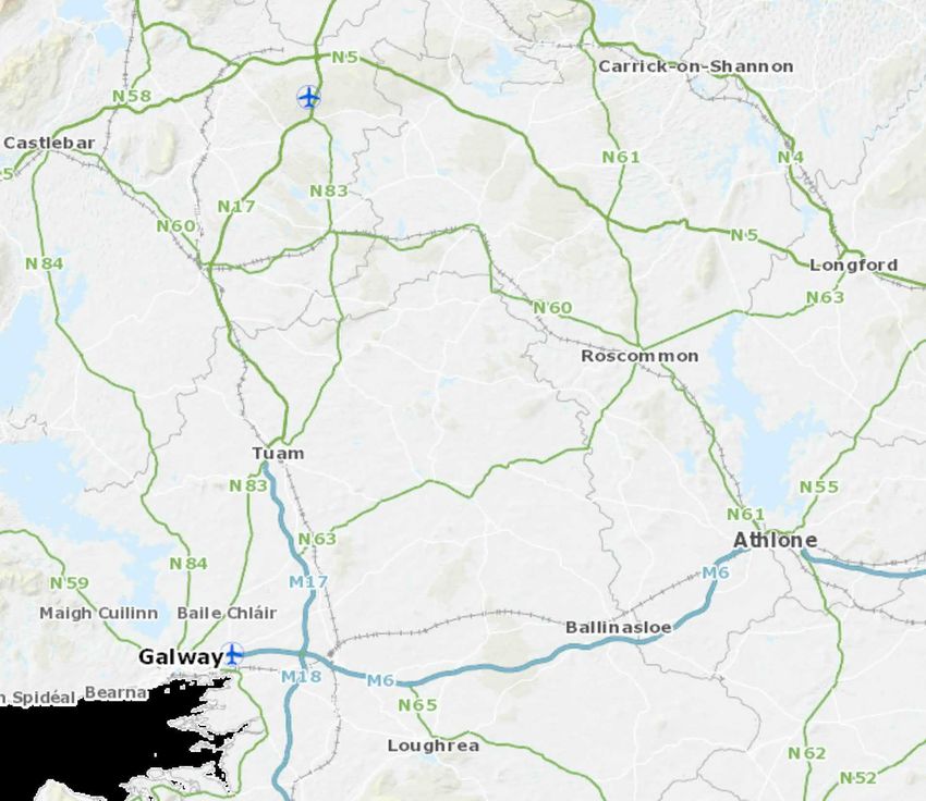
Table of Contents
1      Introduction and Background .............................................................................................................2
1.1       Introduction ....................................................................................................................................2

1.2       Background to the National Water Resources Plan (NWRP) .........................................................2
1.3       Strategic Environmental Assessment ...........................................................................................10
1.5       Consultation .................................................................................................................................15

2      Review of Relevant Plans, Policies and Programmes......................................................................18
3      Baseline Environment......................................................................................................................21
3.1       Scope of the assessment .............................................................................................................21

3.2       High level environmental trends in the EM region and across Ireland ..........................................23
3.3       Population, economy, tourism and recreation, and human health ................................................23
3.4       Water Environment ......................................................................................................................28
3.5       Biodiversity, Flora and Fauna ......................................................................................................30
3.6       Material Assets ............................................................................................................................31
3.7       Landscape and Visual Amenity ....................................................................................................32
3.8       Air Quality and Noise ...................................................................................................................32
3.9       Climate Change ...........................................................................................................................32
3.10      Cultural Heritage ..........................................................................................................................36
3.11      Geology and Soils ........................................................................................................................37
4      Proposed Scope of Assessment and Methodology ..........................................................................39
4.1       Scope of Assessment ..................................................................................................................39
4.2       Proposed SEA Objectives ............................................................................................................40
4.3       Interrelationships between SEA topics .........................................................................................43
4.4       Assessment Approach .................................................................................................................44
4.5       Structure of the Environmental Report .........................................................................................50
5      Next Steps.......................................................................................................................................52
Glossary .................................................................................................................................................53

References .............................................................................................................................................55
Appendix A             Figures ..........................................................................................................................60
Appendix B             Policy, Plan and Programme Review ......................................................................... B-64
B.1       National and regional level ....................................................................................................... B-64
B.2       Local level................................................................................................................................ B-66
Appendix C             SEA Screening Statement ......................................................................................... C-71
ii | Regional Water Resources Plan: Eastern and Midlands – SEA Scoping Report
C.1     Legislative Requirements ......................................................................................................... C-71

C.8     Conclusion ............................................................................................................................... C-74

iii | Regional Water Resources Plan: Eastern and Midlands – SEA Scoping Report
Introduction
            1                                   and
                                                Background

1 | Irish Water | Regional Water Resources Plan: Eastern and Midlands – SEA Scoping Report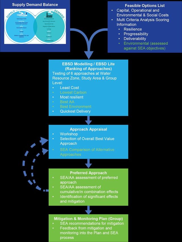
This Section includes:
            •    An introduction to the need for the National Water Resources Plan (NWRP), and the plan
                 for delivery of the NWRP
            •    An introduction to the Eastern and Midlands (EM) region that this Regional Plan covers
            •    Background to the SEA process and how it is integrated with delivery of the Regional Plan
                 and the NWRP
 Scoping question: Do you have any suggestions that you would like Irish Water to consider in the
 preparation of the Eastern and Midlands Regional Plan?

1 Introduction and Background
1.1 Introduction
On the 1st of January 2014, through the Water Services Act (No. 1) 2013, Irish Water assumed statutory
responsibility for the provision of public water services and management of water and wastewater
investment. Irish Water’s role is to provide public water and wastewater services throughout the country.
They are the custodian with the responsibility to manage the precious water resources and, with Local
Authority partners, secure it for future generations. It is their responsibility to ensure that all their
customers receive a safe and secure supply of drinking water and have their wastewater collected,
appropriately treated and returned to the environment. Irish Water support Ireland’s social and economic
growth in a sustainable manner through appropriate investment in water services and protect the
environment in all their activities.

Effective water services, including the delivery of a sustainable and reliable clean water supply and safe
disposal of wastewater, are essential for a modern country. Being able to understand and estimate how
much water is required, where it is required, and the variability of requirements over the course of the
year or over time, is essential to plan appropriately for the future of the public water supply.

1.2 Background to the National Water Resources Plan (NWRP)
1.2.1       Water Resource Planning
A Water Resources Plan is a strategic plan used to identify deficiencies and need across a water supply
and to develop plan level capital and operational solutions to address these issues.
Irish Water’s National Water Resources Plan (NWRP) will be the first resources plan for the public water
supply in the Republic of Ireland. It will allow Irish Water to integrate Government Policy, Legislation and
external factors that have the potential to impact their water supplies into the planning and operation of
their existing and future supply asset base.
The objective of the NWRP is to manage customer and communities’ needs while meeting their
requirements over the short, medium and long term by ensuring safe, secure, sustainable and reliable
water supplies. The NWRP will:
        •       Enable Irish Water to address needs across their water supplies in the most effective way over
                time through the regulated investment cycles proposed as part of the NWRP;

2 | Regional Water Resources Plan: Eastern and Midlands – SEA Scoping Report
• Ensure that there is a transparent framework to develop the most appropriate
projects/programmes to meet statutory obligations in relation to water supply; and
• Provide a framework to track outcomes, allowing interventions to be prioritised to bring the
water supply up to the required standards in the shortest possible timeframe.
Water Resources Plans are reviewed on a cyclical basis to take account of new information, data,
policies and laws and are usually updated every 5 years. Irish Water know things will change over the
next 25 years so within the NWRP they have considered a range of possible futures, some more
challenging than others. This approach is called adaptive planning, and means Irish Water are ready and
flexible whatever the future holds.
A glossary of technical terms used is included at the end of the document.
1.2.2 Delivery of the NWRP
Due to the scale of the NWRP, which covers an entire country, it will be delivered in two stages:
• Phase 1: Framework Plan: a description of the options assessment methodology Irish Water
proposes to use for water resource planning, and assessment of need across Irish Water asset
base in terms of quality, quantity, reliability and sustainability; and
• Phase 2: Regional Water Resource Plans (RWRPs) for the four regional group areas shown
in Figure 1.1 below. The Regional Plans apply the options assessment methodology presented
in the Framework Plan to the national water supply and develop a programme of preferred
short, medium- and long-term solutions and/or groups of solutions to address identified needs
for each area of the supply network.
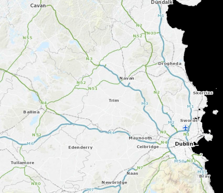
Figure 1.1: Regional Group Areas for roll-out of Phase 2 of the NWRP
3 | Regional Water Resources Plan: Eastern and Midlands – SEA Scoping Report
The RWRPs are referred to as follows:
• Regional Water Resources Plan: North West (Group Area 1);
• Regional Water Resources Plan: South West (Group Area 2);
• Regional Water Resources Plan: South East (Group Area 3); and
• Regional Water Resources Plan: Eastern and Midlands (Group Area 4).
Phase 1 of the NWRP is now complete. The Framework Plan and accompanying SEA Environmental
Report and Natura Impact Statement (NIS) were finalised in May 2021 following a period of public
consultation and update. These documents are available to view on our website at the following location:
www.water.ie/nwrp
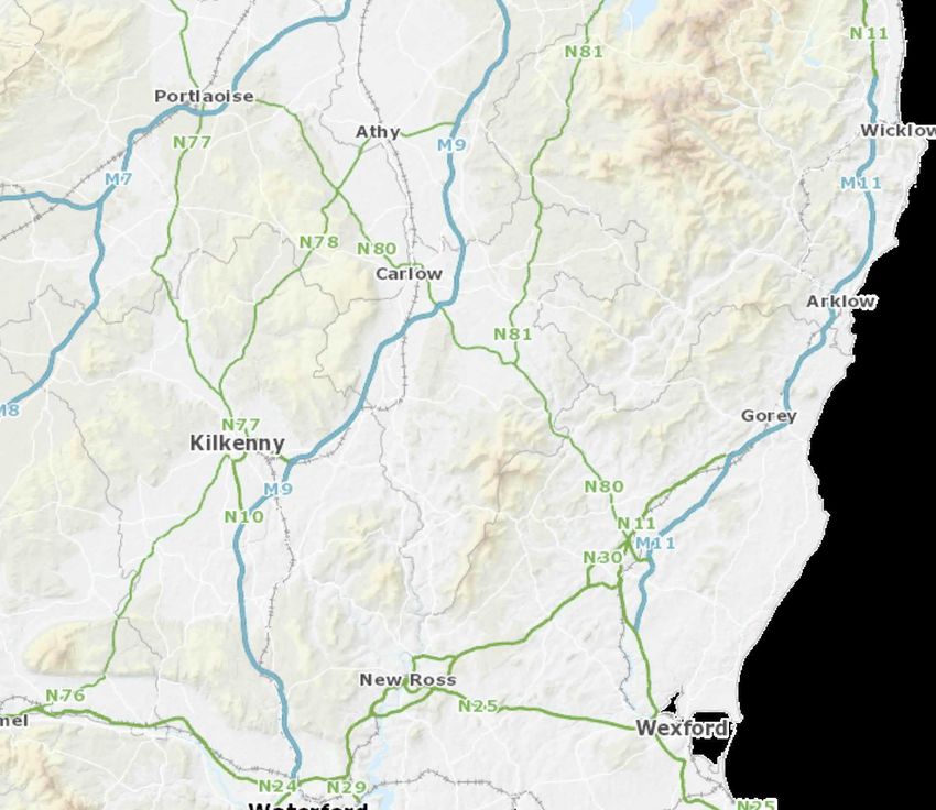
1.2.3 Regional Plan: Eastern and Midlands (RWRP-EM)
This document is the SEA Scoping Report for the Regional Water Resources Plan: Eastern and
Midlands (RWRP-EM). The EM region is further subdivided into nine Study Areas based on Water
Framework Directive (WFD) catchment and Water Resource Zone (WRZ) boundaries within the region,
as shown in Figure 1.2.
Figure 1.1: RWRP-EM Study Areas
An overview of the nine EM Study Areas is provided in Table 1.1.
4 | Regional Water Resources Plan: Eastern and Midlands – SEA Scoping Report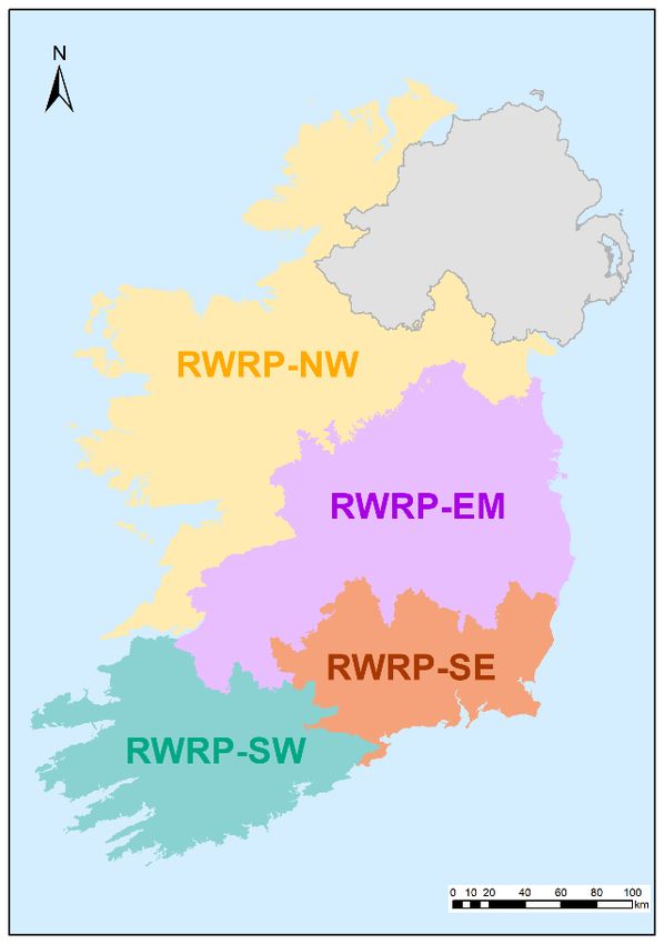
Table 1.1 Overview of RWRP-EM Study Areas

  Study Area                        Description

                                     SA1 total area is approximately 682 km2 and lies within the counties Wicklow and
   SA1 Mid Wicklow                   Wexford. The principal settlement (with a population of over 10,000) within SA1 is
                                     Arklow (CSO, 2016)

                                     SA2 total area is approximately 545 km2 and lies within the counties of Carlow,
                                     Kildare and Wicklow. There are no principal settlements (with a population of over
   SA2 West Wicklow
                                     10,000) within SA2, the largest settlement is Baltinglass, with a population of 2,137
                                     (CSO, 2016)

                                     SA3 total area is approximately 2,404 km2 and lies within the counties of Cavan,
                                     Louth, Fingal, Westmeath and Meath. The principal settlements (with a population of
   SA3 Meath South Louth
                                     over 10,000) within SA3 are Navan, Drogheda, Laytown-Bettystown-Mornington-
                                     Donacarney and Ashbourne (CSO, 2016)

                                     SA4 total area is approximately 2,637 km2 and lies within the counties of Westmeath,
   SA4 Mullingar                     Meath, Kildare, Longford, Cavan and Offaly. The principal settlement (with a
                                     population of over 10,000) within SA4 is Mullingar (CSO, 2016)

                                     SA5 total area is approximately 2,597 km2 and lies within the counties of Galway,
   SA5 Offaly Roscommon              Roscommon, Longford, Westmeath, North Tipperary, Offaly and Laois. The principal
                                     settlement (with a population of over 10,000) within SA5 is Athlone (CSO, 2016)

                                     SA6 total area is approximately 3,027 km2 and lies within the counties of Carlow,
                                     Kildare, Kilkenny, Laois, North Tipperary, Offaly, South Tipperary, Westmeath,
   SA6 Laois
                                     Wexford and Wicklow. The principal settlements (with a population of over 10,000)
                                     within SA6 are Carlow, Portlaoise and Tullamore (CSO, 2016)

                                     SA7 total area is approximately 1,455 km2 and lies within the counties of Clare,
                                     Galway, Laois, North Tipperary, and Offaly. There are no principal settlements (with
   SA7 North Tipperary
                                     a population of over 10,000) within SA7. However, the main settlements (with a
                                     population of over 5,000) are Nenagh and Roscrea (CSO, 2016)

                                     SA8 total area is approximately 4,221 km2 and lies within the counties of Clare, Cork,
                                     Galway, Limerick, Limerick City, North Tipperary and South Tipperary. The principal
   SA8 Limerick
                                     settlements (with a population of over 10,000) within SA8 are Limerick City and
                                     Suburbs, and Ennis (CSO, 2016)

                                     SA9 total area is approximately 3,113 km2 and lies within the counties of Dublin City,
                                     Dun Laoghaire-Rathdown, Fingal, Kildare, Meath, South Dublin and Wicklow. The
   SA9 Greater Dublin Area           principal settlements (with a population of over 10,000) within SA9 are Balbriggan,
   (GDA)                             Bray, Celbridge, Droichead Nua (Newbridge), Dublin City and suburbs, Greystones-
                                     Delgany, Leixlip, Malahide, Maynooth, Naas, Skerries, Swords and Wicklow (CSO,
                                     2016)

1.2.4    Scope of the Regional Plan
The aim of the RWRP–EM is to allow Irish Water to maintain a balance between supply and demand. A
supply demand balance forecast will enable the identification of any current or predicted water supply
deficits from each WRZ. Using this information, a list of potential option types to address that deficit has

5 | Regional Water Resources Plan: Eastern and Midlands – SEA Scoping Report
been developed, as detailed in Table 1.2 below. The RWRP-EM methodology will assess the WRZ and
the sources within them to identify options that could provide a sustainable, reliable source of water into
the future.

Table 1.2 Option types

   RWRP category                    RWRP sub-category                 Summary

   Lose Less

                                                                      Reducing leakage from the network is a priority for
                                                                      Irish Water. This can involve a range of measures for
                                                                      actively detecting and repairing leaks such as the
                                                                      installation of meters to better identify customer
                                                                      leakage activity and advanced monitoring tools and
                                                                      techniques to better identify leaks.
   Leakage Reduction
                                                                      Leakage reduction will focus on targeted replacement
                                                                      of ageing pipes, pressure management to minimise
                                                                      fluctuations and excessive pressures providing more
                                                                      constant pressures to Irish Water customers whilst
                                                                      reducing bursts and the application of different leak
                                                                      repair approaches to minimise cost and disruption.

   Use Less

                                                                      Environmental awareness/education campaigns and
                                                                      partnerships and distribution of educational materials
                                    Education & Awareness
                                                                      to raise awareness of water shortages and encourage
                                                                      water conservation and efficiency.

                                                                      Use of water efficient products and processes in new
                                                                      and refurbished housing developments and working
                                                                      with building standards to ensure that water efficiency
                                                                      measures are included in standards regulations as
                                                                      mandatory. Encouraging take up of water efficiency
                                                                      measures by domestic and non-domestic customers
                                    Water Efficiency                  such as more efficient appliances, repair of leaking
   Water Efficiency
                                    Measures                          toilets, use of water audits.

                                                                      Actively pursue business customers and industry for
                                                                      partnerships that involve water efficiency goals.

                                                                      Investigate how to use water within Irish Water’s
                                                                      existing assets more efficiently through improved
                                                                      treatment processes and recycling of effluent water for
                                                                      appropriate uses.

                                                                      The recycling of treated wastewater or grey water
                                                                      provides a critical supplementary water source for
                                    Recycling and Reuse
                                                                      non-potable activities therefore alleviating stress on
                                                                      primary water sources. Grey water refers to the water

6 | Regional Water Resources Plan: Eastern and Midlands – SEA Scoping Report
RWRP category RWRP sub-category Summary
used in baths, sinks, washing machines, and other
kitchen appliances. In periods of drought, when
potable water is in short supply, grey water can be a
potential alternative water source for activities such as
agricultural and landscape irrigation, industrial
process, and toilet flushing.
Domestic water metering can build a better
understanding of water use and network pressures to
improve water efficiency and therefore water security
and identify leaks.
Metering
Water meters with advanced analytics to undertake
flow balances across the network can allow Irish
Water to gain a better understanding of the whole
network from the abstraction point to the customers
Supply Smarter – resource supply options1
Increasing the abstraction at an existing river or lake
Surface Water source or developing a new river or lake source from
Surface Water
Abstraction which water can be sustainably abstracted. These
options would be subject to an abstraction licence.
Increasing the abstraction at an existing groundwater
source or developing a new groundwater source from
Groundwater Abstraction
which water can be sustainably abstracted. These
options would be subject to an abstraction licence.
Storage of treated or raw water in suitable aquifers.
During times of plentiful water supply, excess water
Groundwater withdrawn from a river, lake or another groundwater
source is injected and stored within an aquifer. This
Aquifer Storage Recovery supplementary stored water can be extracted from the
aquifer during periods of dry weather and/or increased
demand when the primary supply sources are running
low. This requires aquifers with suitable characteristics
to be available as the risks of losses can be high.
1 It is important to note that these option types are not necessarily alternatives to each other; in the majority of the WRZs a combination of
options will be selected as the preferred / recommended approach. For example, surface water and groundwater abstractions can be used in
combination, this is called conjunctive use and involves the storing of surface water in groundwater basin in wet years and withdrawing it from
the basin in dry years. Additionally, most new or increased abstractions will involve upgrades to or construction of new WTPs and new or
upgraded transfers.
7 | Regional Water Resources Plan: Eastern and Midlands – SEA Scoping ReportRWRP category RWRP sub-category Summary
Provision of storage reservoirs which can be filled with
untreated water abstracted during high flow conditions
Reservoirs Storage Reservoirs from surface waters to be drawn on during low flow
periods or to provide additional resilience during
droughts as a back-up supply source.
Activities such as agriculture, forestry, industry and
waste management all have an impact on the
retention of water in the catchment and the quality of
the water within rivers and loughs. Pollutants in the
water can lead to ecological deterioration, increased
Catchment management flood risk and can also create issues for water
Catchment
for ground or surface treatment. There may be scope for changes to land
Management
water sources management through working in partnership with
landowners, farmers and regulators to develop
agreements and share information and resources to
provide long term improvements with wide benefits
including water suitable for supply from surface of
groundwaters.
Recycling of wastewater effluent from treatment plants
can produce a new supply source from wastewater
which is otherwise discharged to rivers or the sea.
This involves treating wastewater to a sufficiently high
Effluent Reuse Effluent Reuse
standard to meet supply standards relevant for the
intended use for example for
agricultural/horticulture/industry/water supply or for
release to rivers to maintain flows.
This involves the process of removing salt and other
minerals from seawater or brackish water2 river
Desalination:
Desalination estuaries to make it suitable for human consumption
Coastal or Brackish
and/or industrial use. The level of treatment required is
related to the salt concentration of the water.
Water transfer is the physical movement of water from
one area to another usually via pipelines, although
other means such as canals or aqueducts can be
used. These generally refer to the transfer of treated
Water Transfers Transfers
water and can vary considerably in scale in terms of
size and length from local transfers from one WRZ to
another, to regional transfers and inter-utility transfers
(from Northern Ireland Water)3.
2 Brackish water is water that has more salt than freshwater, but not as much as seawater that is generally found in estuaries.
3 No inter-utility transfers have been identified for the EM region
8 | Regional Water Resources Plan: Eastern and Midlands – SEA Scoping ReportRWRP category RWRP sub-category Summary
Delivery of treated water to customers via road tanker
Tankering to alleviate temporary short-term water shortages in
certain localised situations.
Network improvement involves works such as
upgrade, replacement or operational improvements.
They are undertaken to facilitate better water
Network Improvements
distribution and avoid network limitations. Therefore,
(general)
strategic network reinforcement improving connections
between different sources and customer supply can
Network Improvements significantly improve security and resilience.
Service reservoirs store treated water. They are used
to balance out the steady supply of treated water they
Service Reservoir receive from WTPs and the fluctuating variations in
Expansion customer demand during a 24-hour period. They can
also be used to store a backup supply in low flow
events but for a limited period of time.
Expansion of existing WTPs to facilitate the treatment
of a higher volume of water. This option would be
considered in-combination with an increase of a
surface water or ground water abstraction or the
provision of a new surface water our ground water
WTP
source. Expansion of existing WTPs may be carried
Expansion/Rationalisation
out as part of a rationalisation process which involves
the merging of WTPs. Rationalisation is carried out to
reduce water supply costs, take a malfunctioning WTP
out of service or to cease abstraction from an
unsustainable source.
Water Treatment Plants
For every litre of untreated water extracted from a
source and fed through a water treatment plant to the
supply distribution network, a small fraction of the
water will be lost from the system as a result of the
treatment losses. Generally, WTPs are designed to
WTP Process Losses recover, treat and recycle as much of the waste
stream as economically feasible. However, there can
be opportunities to improve efficiency through the
upgrading and installation of more complex treatment
processes to reduce these process losses and
therefore increase the WAFU.
9 | Regional Water Resources Plan: Eastern and Midlands – SEA Scoping Report1.3 Strategic Environmental Assessment
1.3.1 Legislative Requirement
Council Directive 2001/42/EC of the European Parliament and of the Council of 27th June 2001 on the
assessment of the effects of certain plans and programmes on the environment (the SEA Directive)
established the statutory requirement for SEA as part of the development of certain plans and
programmes. The Directive is applicable to the Framework Plan and the Regional Plans of the NWRP.
The transposing Irish Regulations are the European Communities (Environmental Assessment of Certain
Plans and Programmes) Regulations 2004 (S.I. No. 435 of 2004) as amended by the European
Communities (Environmental Assessment of Certain Plans and Programmes) (Amendment) Regulations
2011 (S.I. No. 200 of 2011).
In accordance with the overall objective of the SEA Directive as set out in Article 1, a SEA is required to:
“Provide for a high level of protection to the environment and to contribute to the integration of
environmental considerations into the preparation and adoption of plans and programmes with a view to
promoting sustainable development…”
According to Article 2 of the Directive, "plans and programmes" means plans and programmes, including
those co-financed by the European Community, as well as any modifications to them:
• Which are subject to preparation and/or adoption by an authority at national, regional or local
level or which are prepared by an authority for adoption, through a legislative procedure by
Parliament or Government; and
• Which are required by legislative, regulatory or administrative provisions.
Under Article 3(2), an environmental assessment:
“…shall be carried out for all plans and programmes, (a) which are prepared for agriculture, forestry,
fisheries, energy, industry, transport, waste management, water management, telecommunications,
tourism, town and country planning or land use and which set the framework for future development
consent of projects listed in Annexes I and II to Directive 85/337/EEC4 .”
1.3.2 SEA Process
The purpose of SEA is to enable plan-making authorities such as Irish Water to incorporate
environmental considerations into decision-making at an early stage and in an integrated way throughout
the plan-making process. The SEA process is undertaken in four stages. The progress against each
stage of the SEA process for the RWRP-EM Regional Plan is summarised in Table 1.3. The SEA
process for Phase 1 of the NWRP, the Framework Plan, has already been completed.
Table 1.3 Stages of SEA
Stage Purpose and requirements Progress to date / current status
Stage 1: Screening Prior to starting the SEA process, a plan SEA Screening Statement – Irish Water
or programme undergoes “screening” to (as the responsible authority) determined
determine whether it requires SEA. that SEA was required for the NWRP
when screening was carried out in August
2017. A SEA screening statement for the
4 Replaced by 2011/92/EU as amended by 2014/52/EU
10 | Regional Water Resources Plan: Eastern and Midlands – SEA Scoping ReportStage Purpose and requirements Progress to date / current status
Regional Plan EM is provided in Appendix
C.
Stage 2: Scoping Consideration of the context and SEA Scoping Report – The SEA Scoping
objectives of the SEA provides Report sets the geographical and
information on baseline data, identifies temporal scope of the draft Regional Plan
relevant environmental issues and trends, and SEA, the baseline environment and a
and defines the parameters of the scope proposed framework of SEA objectives to
of the SEA for the purpose of inform the Stage 3 assessment.
consultation.
Stage 3: Identification, Within the context and parameters Environmental Report (SEA of the draft
Prediction, Evaluation and identified at the scoping stage. Regional Plan)
Mitigation of Potential Identification and evaluation of likely
Effects significant effects of the draft Regional
Plan is carried out, including
consideration of alternatives and
determination of measures to mitigate and
monitor potential residual effects.
Stage 4: Consultation, Consultation with statutory consultees Stage 4: Consultation, Revision and Post-
Revision and Post- and the public. This may require changes Adoption
Adoption to the draft Regional Plan and SEA
Environmental Report in light of
responses. Publication of the final
Regional Plan and SEA Statement.
Implementation of the monitoring
programme.
1.3.3 Appropriate Assessment
In addition to compliance with the SEA Directive, the preparation and implementation of the NWRP must
meet the provisions of the Habitats Directive (92/43/EEC). The Habitats Directive has been transposed
into Irish law by the Planning and Development Act, 2000 (as amended) and the European Communities
(Birds and Natural Habitats) Regulations 2011 (S.I. No. 477 of 2011). The Habitats Directive requires
that if a plan, policy or programme is likely to have a significant effect on one or more European sites
(that is, a Special Area of Conservation (SAC) or Special Protection Area (SPA), also referred to as
“Natura 2000” Network), either alone or in combination with other schemes, plans or projects, then it
must be subject to Appropriate Assessment (AA).
The NWRP therefore falls under the governing legislation of the European Communities (Birds and
Natural Habitats) Regulations 2011 (Habitats Regulations 2011); and as a “competent authority”, Irish
Water must ensure that their NWRP meets these requirements. The Stage 1 (screening) assessment
has concluded that it cannot be excluded, on the basis of objective scientific information following
screening that the draft RWRP-EM, individually or in combination with other plans or projects, will have a
11 | Regional Water Resources Plan: Eastern and Midlands – SEA Scoping Reportsignificant effect on one or more European sites. Accordingly, a full Stage 2 Appropriate Assessment will
be required in accordance with the Habitats Regulations 2011.
1.3.4 Integration between SEA (and AA) and the draft Regional Plan and the Framework Plan
The options development process which Irish Water propose to use to develop the Preferred Approach
for all Regional Plans is described within the Framework Plan and was subject to a separate SEA
process and finalised in May 2021. The options assessment methodology is outlined briefly below, with
further detail available within the Framework Plan and the SEA Statement which accompanies the
Framework Plan which can both be found at: www.water.ie/nwrp
There are eight key stages to the options assessment methodology which is applied:
1) Identifying need - based on Supply Demand Balance and/or Drinking Water Safety Plan Barrier
Assessment.
2) Scoping of the Study Area (WRZs) – understanding the Study Area and the existing conditions
of assets, supply and demand issues as well as environmental constraints and opportunities.
3) Identifying potential options for consideration relevant to the Study Area.
4) Coarse screening – assess the unconstrained options and eliminate any that will not be viable
5) Further option definition, information collection and preliminary costing.
6) Fine screening – options assessment and scoring against the key criteria with further removal of
options identified as unviable and development of feasible options for costing (including
environmental and social costs and benefits) and scoring assessment update.
7) Approach appraisal – comparison and assessment of combinations of options identified to meet
the predicted supply demand deficit at WRZ, Study Area and Regional Group area level using
Multi-Criteria Analysis (MCA) to determine the preferred approach. Approaches tested will
include:
- Least Cost;
- Best Appropriate Assessment (Best AA);
- Quickest Delivery;
- Best Environmental;
- Most Resilient; and
- Lowest Carbon.
8) Monitoring and Feedback into Plan – a feedback mechanism to ensure that the Framework Plan
continuously adapts to changes such as evolving scientific data, understanding, and policy
change in relation to the natural environment.
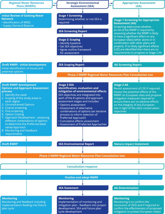
Figure 1.3 illustrates how SEA influences each stage of the options development process and options
assessment methodology outlined above, and Figure 1.4 shows how the SEA and AA reporting will align
with each other and with development of the draft RWRP-EM.
12 | Regional Water Resources Plan: Eastern and Midlands – SEA Scoping ReportFigure 1.3 SEA influence on draft RWRP-EM development 13 | Irish Water | Regional Water Resources Plan: Eastern and Midlands – SEA Scoping Report
Figure 1.4 Integration between SEA and AA processes and development of the draft RWRP-EM

14 | Irish Water | Regional Water Resources Plan: Eastern and Midlands – SEA Scoping Report
1.5 Consultation
In line with Article 9 (5) of the SEA Regulations (S.I. No. 435 of 2004), this SEA Scoping Report will be
issued to the following statutory Environmental Authorities:
      •    The Environmental Protection Agency (EPA);
      •    Department of Housing, Local Government and Heritage (DHLGH);

      •    The Department of Tourism, Culture, Arts, Gaeltacht, Sport and Media (DTACGSM);
      •    The Department of Agriculture, Food and the Marine (DAFM);
      •    Department of the Environment, Climate and Communications (DECC); and

      •    Northern Ireland Department of Agriculture, Environment and Rural Affairs (DAERA) (related to
           transboundary issues).
This SEA Scoping Report is available online at the following website:

      https://www.water.ie/nwrp
Further information requests and written submissions or observations can be sent to Irish Water by the
23rd July 2021:

  By post:                                                         By email:
  National Water Resources Plan,                                   nwrp@water.ie
  Irish Water,
  PO Box 13216,
  Glenageary,
  Co. Dublin.

The following key questions have been prepared to guide consultees and stakeholders in making a
submission on this SEA Scoping Report and are repeated under the relevant Sections throughout the
report.

Scoping questions:

     •    Do you have any suggestions that you would like Irish Water to consider in the preparation of
          the RWRP-EM?
     •    Irish Water has reviewed plans, policies and programmes relevant to the RWRP-EM in
          Chapter 2 and Appendix B. Are there any others that should be considered?
     •    Do you have any comment on the current baseline environment conditions and future trends
          set out in Chapter 3 and summarised in Section 3.11?

     •    Do you have any comment on the SEA objectives that are set out in Table 4.1?
     •    How would you like Irish Water to communicate with you as the development of the draft
          Regional Plan progresses?

15 | Regional Water Resources Plan: Eastern and Midlands – SEA Scoping Report
All submissions made on the SEA Scoping Report will be reviewed and relevant feedback incorporated into the SEA Environmental Report and draft RWRP-EM as appropriate. The issues raised, and the response will be summarised in the SEA Environmental Report. No potential for transboundary effects has been identified (see Section 4.2.1 for further detail). 16 | Regional Water Resources Plan: Eastern and Midlands – SEA Scoping Report
Review of
                                               Relevant
            2                                  Plans, Policies
                                               and
                                               Programmes

17 | Regional Water Resources Plan: Eastern and Midlands – SEA Scoping Report
2 Review of Relevant Plans, Policies and Programmes
This Section provides a summary of the plans, policies and programmes that have been identified as
potentially important in development of the baseline environment and SEA objectives for the SEA of
the draft RWRP-EM.
Scoping question: Irish Water has reviewed plans, policies and programmes relevant to the draft
RWRP-EM in Chapter 2 and Appendix B. Are there any others that should be considered?
The SEA Directive states in Article 5(1) of Annex 1 that the environmental assessment must identify “the
environmental protection objectives, established at International, European Union or national level, which
are relevant to the plan or programme, or modification to the plan or programme, and the way those
objectives and any environmental considerations have been taken into account during its preparation”.
In accordance with this requirement, the relationship with the relevant policy, plan programme and
legislative framework was explored in order to inform the scope of the SEA and to provide a focus for
identifying the baseline environment and development of the SEA objective.
A comprehensive review of relevant national and regional level policies, plans, programmes and
legislative framework of relevance to water resource planning, including related Irish Water plans and
strategies, has been undertaken and consulted upon within SEA Environmental Report for the
Framework Plan available at www.water.ie/nwrp The identified documents will also be directly relevant to
the draft RWRP-EM and are provided in Appendix B (Section B.1). Key influences identified at the
national level which also apply to the RWRP-EM include:
• EU WFD (Directive 2000/60/EC of the European Parliament and of the Council establishing a
framework for Community action in the field of water policy);
• River Basin Management Plan for Ireland 2018-2021 (due to be updated during 2021);
• General Scheme on Water Environment (Abstractions) Bill 2018;
• National Planning Framework – Project Ireland 2040;
• National Adaptation Framework Sectoral Adaptation Planning;
• Regional Spatial and Economic Strategy (RSES) for the Eastern and Midlands Region, RSES
for the Southern Region and RSES for the Northern and Western Regional Assembly; and
• Related Irish Water plans and strategies including the Water Services Strategic Plan (Tier 1
plan), National Wastewater Sludge Management Plan, Lead in Drinking Water Mitigation Plan,
Sustainable Energy Strategy - Climate Change Mitigation and Adaptation Strategy, Leakage
Reduction Programme and National Disinfection Programme.
A focussed list of additional local level plans policies and strategies relevant to RWRP- EM specifically is
provided in Section B.2 of Appendix B. Regional and local level plans likely to be key for the purposes of
the SEA for the draft RWRP-EM fall under four main groups as follows:
• County Development Plans, Local Area Plans and Town Development Plans - Planning
Authorities are legally required to make County and City Development Plans which sets an
agenda for development to make adequate provision for the scale of population growth
projected;
18 | Regional Water Resources Plan: Eastern and Midlands – SEA Scoping Report• County Heritage Plans and County Biodiversity Action Plans – these plans help ensure targets
for species and habitat conservation in the National Biodiversity and Heritage Plans are
effective at a local level;
• County Climate Change Adaptation Strategies and Climate Action Plans – these strategies and
plans establish future climate risks at a local level and propose actions to adapt to currently
observed and future climatic changes;
• County Landscape Character Assessments – these assessments classify and describe the
landscape in a county; and
• Regional Waste Management Plans.
Other relevant plans, policies and strategies considered and listed within Appendix B include
Conservation Plans, Renewable Energy Strategies, Community Biodiversity Action Plans and Noise
Action Plans.
19 | Regional Water Resources Plan: Eastern and Midlands – SEA Scoping Report3 Baseline
Environment
20 | Irish Water | Regional Water Resources Plan: Eastern and Midlands – SEA Scoping Report3 Baseline Environment
This Section sets the proposed geographical and temporal scope of the SEA for the RWRP-EM, and
provides environmental baseline information on key environmental topics including:
• Population, Economy, Tourism and Recreation, and Human Health;
• Water Environment;
• Biodiversity, Flora and Fauna;
• Material Assets;
• Landscape and Visual Amenity;
• Air Quality and Noise;
• Climate Change;
• Cultural Heritage;
• Geology and Soils.
Scoping question: Do you have any comment on the current baseline environment conditions and
future trends set out in this chapter and summarised in Sections 3.1-3.11?
3.1 Scope of the assessment
3.1.1 SEA geographical scope
As this stage of the assessment the core baseline area for the SEA of the draft RWRP-EM is the area
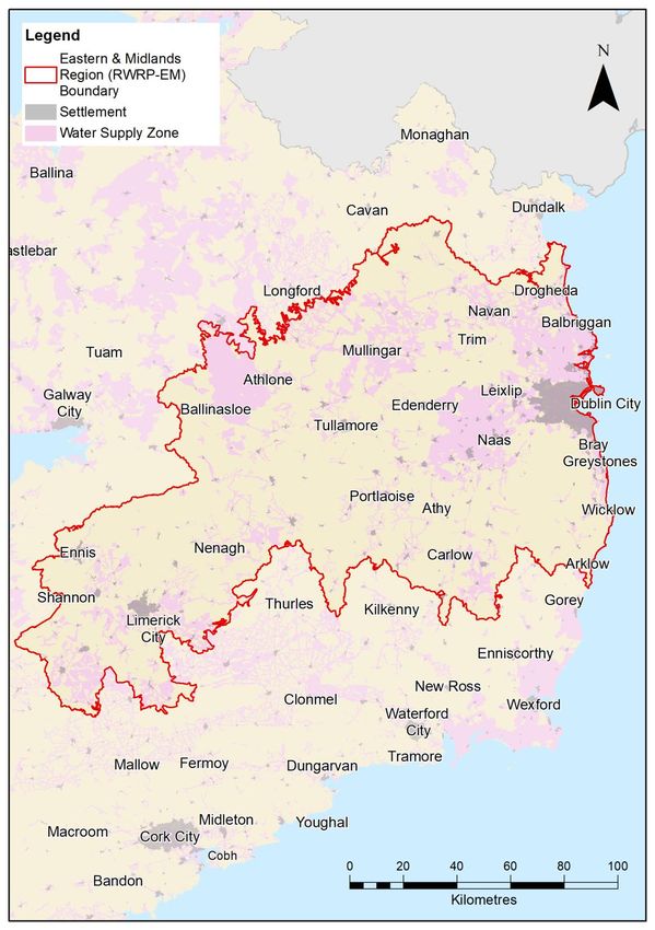
covered by the nine Study Areas which comprise the EM region (see Figure 3.1) and sites designated for
nature conservation that are hydrologically connected to waterbodies in the core baseline area (see
Section 3.5 of the RWRP-EM Screening for AA at www.water.ie/nwrp. The assessment process
undertaken for the SEA and AA (see Section 4.2) during evolution of the Plan will consider the potential
21 | Regional Water Resources Plan: Eastern and Midlands – SEA Scoping Reportfor linkages of this type, and where necessary, the geographic scope of the core baseline area will be extended accordingly. Figure 3.1 Water Supply Zones and Key Settlements in the Eastern and Midlands region 3.1.2 Transboundary Effects The RWRP–EM will solely cover Irish Water’s operational area for the Eastern and Midlands which lies approximately 20km from the boundary between the Republic of Ireland and Northern Ireland (see Figure 3.1). Transboundary effects are not predicted on the basis that the border with Northern Ireland is at the distance noted, there are no shared groundwater WFD units, and that the one shared hydrometric 22 | Regional Water Resources Plan: Eastern and Midlands – SEA Scoping Report
area (area 06 Newry, Fane, Glynde and Dee - a small area north of Drogheda) predominantly
discharges to Dundalk Bay. Transboundary policies and plans have been reviewed as listed in Appendix
B and potential for transboundary effects will be considered in the Environmental Report.

3.1.3       SEA temporal scope
The proposed temporal scope for the SEA is the 25-year period between 2021 and 2046 that is covered
by the Framework Plan and draft RWRP-EM.

3.2 High level environmental trends in the EM region and across Ireland
The EPA’s State of the Environment Report (EPA, 2020) provides:
        •    An assessment of the overall quality of Ireland’s environment;
        •    An outline of the pressures being placed on this environment; and

        •    The key actions that can address these pressures.
The following areas identified as challenges to address across Ireland within this report are particularly
pertinent to development of the EM-NWRP:

        •    Climate: high greenhouse gas (GHG) emissions continue, and the scale and pace of GHG
             reductions must accelerate to meet 2019 Climate Action Plan targets;
        •    Water: deteriorating water quality trends over the last 20 years, particularly for rivers; and

        •    Nature: deteriorating protected habitat trends, with 85% of EU protected habitats having
             unfavourable status. Trends for EU protected species are mixed, however freshwater species
             are most at risk and some freshwater species are under threat.

Waste and the circular economy and air quality are also areas where further action is needed to meet
long term objectives and targets.
Further detail regarding the baseline environment for each of these topic areas is provided in the
following sections.

3.3 Population, economy, tourism and recreation, and human health
3.3.1       Population
The EM region falls within six of the eight regional authority areas in Ireland. Table 3.1 provides an
overview of the population of Study Areas within the draft RWRP-EM region and projected increases in
population between 2019 and 2040. Each Study Area is divided into several WRZs, and the average
percentage population increase during the Plan period anticipated across WRZs within each Study Area
is also shown in Table 3.1.

Table 3.1: Overview of the population within the draft RWRP-EM Area

  Study Area                         Total population served (2019)             Population change 2019-2040 (%)

                  1                                  2,4047                                   17.6

                  2                                  6,841                                    12.9

                  3                                  87,873                                  155.5

                  4                                  72,140                                   44.2

23 | Regional Water Resources Plan: Eastern and Midlands – SEA Scoping Report
Study Area Total population served (2019) Population change 2019-2040 (%)
5 72,140 23.1
6 126,665 17.8
7 31,237 16.7
8 236,896 30.3
9 1,702,245 21.0
draft RWRP-EM Area Total 2,360,083 27.4
3.3.2 Economy and Employment
Study Areas or parts of Study Areas located within Dublin, the Mid-East and Mid-West regions had a
household disposable income per person in 2016 that was around or above the average for Ireland.
Household disposable income was below the Ireland average in those areas located in the West,
Midland and South East regions (CSO, 2020a).
Unemployment rates in 2017 were also highest in the Midland (10.1%) and Mid-West (8.7%) regions,
and lowest in Dublin and the South East (see Table 3.2). However, unemployment data for Q3 2020
shows a very different pattern, with highest rates of unemployment seen in the Dublin followed by the
South East (CSO, 2017a). Whilst the economic impact of COVID-19 has affected some employment
sectors (for example tourism, hospitality, retail) more than others, it is uncertain how this trend might play
out in the coming years.
Table 3.2: Unemployment rates in 2017 and Q3 2020
Unemployment rate 2017 (%) (CSO,
Region1 Unemployment rate Q3 2020 (%) (CSO, 2020b)
2017a)
Dublin 6.6 8.2
Mid-West 8.7 6.8
Midland 10.1 6.9
Mid-East 7.5 6.8
West 7.4 6.4
South East 6.4 7.7
1
See Figure 3.2 (Appendix A) for study area boundaries in relation to regions
Population increase and expected economic growth has meant that housing and sustainable urban
development have been made a priority for the National Development Programme; therefore, to supply
the demand there is the aim to increase housing stock. New dwelling completions for Q3 2019 and Q3
2020 are shown in Table 3.3. Whilst there was a drop in new dwelling completions of 13.6% between
2019 and 2020 across Ireland, associated at least partly with COVID-19 restrictions on the construction
industry, the regional trend in completions has not altered with highest numbers seen in Dublin and the
Mid-East in Q3 of both years. New dwelling completions in Dublin and the Mid-East represented 47.8%
of the completions in Ireland in Q3 2020.
24 | Regional Water Resources Plan: Eastern and Midlands – SEA Scoping ReportTable 3.3: New dwellings completed Q3 of 2019 and 2020
Region1 New dwellings completed in Q3 2019 New dwellings completed in Q3 2020
Dublin 1,912 1,145
Mid-West 326 347
Midlands 219 214
Mid-East 1,499 1,303
West 434 432
South East 397 441
1
See Figure 3.2 (Appendix A) for study area boundaries in relation to regions
3.3.3 Tourism and Recreation
Tourism has an important role in the core baseline area, particularly in rural locations, with the National
Planning Framework (NPF) stating that tourism is a key aspect of rural job creation now and in the future
(Government of Ireland, 2018). The core baseline area is located within Ireland’s Ancient East, Hidden
Heartlands and Wild Atlantic Way, three of Fáilte Ireland’s tourism programmes in the country. The
Ancient East is part of a tourism development strategy that covers the South, East and part of the
Midlands, emphasising the importance of historic sites in the area (National Tourism Development
Authority, 2016). Hidden Heartlands is located in the Mid-West, focussing on rural communities (Fáilte
Ireland, 2020a), and Ireland’s Wild Atlantic Way, which is Ireland’s first long-distance touring route, aims
to achieve greater visibility for the west coast of Ireland (Fáilte Ireland, 2020b).
Key tourist attractions located within the core baseline area are described below.
• The county of Wicklow (Study Areas 1 and 2) has been described as “the garden of Ireland”,
containing Ireland’s largest national park (Wicklow National Park) and emphasising outdoor
recreation as a key asset for the area (Visit Wicklow, 2020).
• Boyne Valley (Study Area 3) has been described as “Ireland’s ancient capital” and contains
Ireland’s UNESCO World Heritage Site at Brú na Bóinne (Newgrange and Knowth) as well as
Ireland’s largest Anglo-Norman castle at Trim (Meath County Council, 2020).
• The county of Westmeath (has been described as “a county… where Ireland’s Ancient East
meets Ireland’s Hidden Heartlands” (Visit Westmeath, 2020) and Offaly as “Ireland’s hidden
gem” (Visit Offaly, 2020)
• The county of Roscommon (Study Area 5) has been described as the “Land of Memories”, with
emphasis placed on the county’s cultural and historical attractions (Visit Roscommon, 2020);
the county of Galway also emphasises these aspects (Visit Galway, 2020).
• The county of Laois (Study Area 6) has been described as an “outdoor enthusiasts paradise”
with emphasis also placed on the county’s cultural and historical attractions (Laois Tourism,
2020); the county of Carlow also emphasises these aspects (Carlow Tourism, 2020).
• The county of North Tipperary (Study Area 7) has been described as the “farming heartland of
Ireland” with emphasis also placed on the county’s cultural and historical attractions (Tipperary
Tourism, 2020). Additionally, the county of Offaly (Study Area 7) highlights the importance of the
county’s natural assets, such as bog lands and mountains (Visit Offaly, 2020).
25 | Regional Water Resources Plan: Eastern and Midlands – SEA Scoping Report• The county of Limerick (Study Area 8) includes Limerick City, the first city of culture, and
emphasises the importance of sports in its touristic appeal (Limerick City and County Council,
2020). The county of Clare also emphasises the county’s natural assets, particularly the rivers
and lakes of East Clare (Visit Clare, 2020).
• The city of Dublin (Study Area 9) has been described as “a vibrant, cool and hip capital city
bursting with a variety of surprising experiences – with sea and mountains at its doorstep”. It
has also been identified as a priority segment and as one of Ireland’s best prospects for growing
tourism by the National Tourism Development Authority (2016).
Ireland’s natural heritage is also recognised as an important tourism asset by the Department of
Transport, Tourism and Sport (2019). Key natural heritage and outdoor recreation attractions within the
core baseline area include:
• Study Areas 1 and 2: Wicklow National Park (Study Area 1 only) and the Glenealo Valley
National Park and Glendalough and Vale of Clara Nature Reserves (both Study Areas);
• Study Area 3: the two main rivers in Meath, the Boyne and the Blackwater, join at Navan and is
the most historic waterway in Ireland, rich in aquatic life, and the salmon and trout are
recognised as among the finest in Ireland;
• Study Area 4: natures reserves of Raheenmore Bog and Scragh Bog, lakes of Westmeath;
• Study Area 5: Mongan Bog, Clara Bog and Redwood Bog;
• Study Area 6: Slieve Bloom Mountains, Timahoe Esker, Grantstown Wood and Grantstown
Lough, and Coolacurragh Wood;
• Study Area 8: Dromore, Cahermurphy, Pollnaknockaun Wood, Derrycrag Wood and Rosturra
Wood; and
• Study Area 9: Rogerstown Estuary, Baldoyle Estuary and North Bull Island Nature Reserves,
and the Wicklow Mountains National Park (Visit Dublin, 2020).
Rivers, loughs and coastal areas across the core baseline area also all make an important contribution
to tourism and recreational opportunities and support important fisheries.
3.3.4 Human Health
Table 3.4 provides well-being indicators for the core baseline area. Improvements in air quality, access
to good quality drinking water and participation in recreation activity can all have a positive influence on
health and well-being.
Table 3.4: Well-being indicators for the core baseline area
Participation in sports,
Air quality
fitness or recreational
Life expectancy (CSO, (Environmental
Region1 physical activities (% of
2017b) Protection Agency
persons aged 15+) (CSO,
(EPA), 2020)
2020c)
Male: 77.2 49 Good
Mid-East
Female: 81.4
Midland Male: 77.2 47 Good
26 | Regional Water Resources Plan: Eastern and Midlands – SEA Scoping ReportParticipation in sports,
Air quality
fitness or recreational
Life expectancy (CSO, (Environmental
Region1 physical activities (% of
2017b) Protection Agency
persons aged 15+) (CSO,
(EPA), 2020)
2020c)
Female: 81.5
Male: 76.3 52 Good
Mid-West
Female: 80.4
Male: 77.1 56 Good
West
Female: 82.7
Male: 76.8 44 Good
South East
Female: 81.7
Male: 76.7 61 Good
Dublin
Female: 81.2
1
See Figure 3.2 (Appendix A) for study area boundaries in relation to regions
Key issues for public health include reliable access to good quality drinking water. Regulated water
service providers have to ensure appropriate service standards of supply and be able to endure drought
conditions, peak events, and maintenance downtime on their assets. This requires reserve capacity in
supplies. At present, the supplies across the RWRP-EM region do not have the reserve capacity to meet
these levels of service at all times. Due to the limited historical monitoring of these supplies, particularly
in relation to groundwater, this will need to be studied further. Study Area 9 has a chronic capacity deficit
and Irish Water’s built assets are operating beyond their sustainable operating capacity on a daily basis
and it is often necessary to depend on treated water storage to meet short term deficits.
Currently for day to day operations, the majority of WRZs within all RWRP-EM Study Areas suggest a
SDB deficit (based on a “do minimum” approach) under present and future scenarios (see Table 3.5 for
further detail). While sufficient in normal weather conditions, several would fail in drought. During the
drought in Summer 2018, all of Irish Water’s groundwater supplies were being monitored due to falling
groundwater levels and a number of supplies were impacted in terms of quality or quantity including
Dunlavin (groundwater) and Hackettstown, Carlow (surface water) in Study Area 3, Toberdaly
(groundwater) and Lough Owel and Lough Lene (both surface water) in Study Area 4 and Pallasgreen,
Oola and Hospital in Study Area 8. Water had to be supplemented via tankered supplies for those areas
in Study Area 8 previously identified as particularly affected by the drought. Significant reductions in
surface water flows were also identified on the River Maigue and River Deel.
Poor water quality can be linked to risks to health. In addition, based on desk study Water Treatment
Plant (WTP) assessments, a significant number of supplies in every Study Area within the EM region
appear to have significant water quality treatment risks (see Table 3.5), and further work is planned to
provide more up to date and reliable assessments. As shown in Table 3.5 a number of supplies within
the core baseline area are either on the EPA Remedial Action List (RAL) or are subject to an EPA
direction, Irish Water are currently progressing corrective action in relation to many of these supplies in
advance of the Regional Plans.
27 | Regional Water Resources Plan: Eastern and Midlands – SEA Scoping ReportTable 3.5: Water quality supply risks
Number of WRZs with Number of supplies for which Number of supplies on EPA
Study
SBD deficit (total significant water quality risks have Direction or Remedial Action
Area
number WRZs) been confirmed List (RAL)
1 14 (18) 16 1
2 9 (12) 11 1
3 10 (11) 17 4
4 9 (13) 13 2
5 7(11) 14 1
6 24 (28) 40 1
7 6 (10) 18 0
8 9 (32) 48 3
9 0 (2) 11 2
3.4 Water Environment
This topic covers geomorphology, WFD, flood risk, surface water quality and groundwater receptors.
Figures 3.3 and 3.4 (Appendix A) show the baseline water environment within the core baseline area,
including the WFD catchment boundaries and WFD status of rivers, lakes, canals, transitional and
coastal waterbodies and groundwater bodies.
3.4.1 Water Framework Directive
Under the Water Framework Directive (2000/60/EC), Ireland must ensure that the waterbodies achieve
“Good Status” by 2027. In addition, under the legislation any modification to a WFD water body should
not lead to deterioration in either the overall status5 or any of the quality elements6. WFD waterbodies
within each of the catchments which intersect the core baseline area are identified in Figures 3.3 and 3.4
(Appendix A).
The General Scheme on Water Environment (Abstractions) Bill 2018 (The Bill), to introduce abstraction
licensing aligned to the WFD, was published in summer 2018. This legislation will set the amount Irish
Water can take from the water supplies they abstract the water from. This will require at least 18% of
Irish Water’s abstractions to be licensed and may limit abstraction at these sites in future. With their
current fragmented supply networks and lack of an alternative supply in many cases, this could result in
immediate impacts.
Irish Water will need time to adapt their operations and deliver the investment required to provide
replacement or auxiliary supplies and put measures in place to reduce demand, where appropriate. The
Bill acknowledges this and recognises that an adaptation period will be necessary to help Irish Water
5
The ecological status assigned for surface water bodies is determined by the status of the poorest quality
element. Overall status of groundwater bodies is assigned based on the combined chemical and quantitative
element statuses.
6 Surface water body status is assessed based on both ecological status or potential and chemical status.
Ecological status includes various quality elements including biological elements, water chemistry and the physical
condition of water bodies.
28 | Regional Water Resources Plan: Eastern and Midlands – SEA Scoping ReportYou can also read