Ballyminion Draft Regeneration Masterplan Public Consultation May 2019 - Prepared By
←
→
Page content transcription
If your browser does not render page correctly, please read the page content below
DRAFT Masterplan                                   May 2019

Ballyminion
Draft Regeneration Masterplan
Public Consultation
May 2019

                                  Prepared By

                                The Regeneration
                                     Section,

                                Longford County
                                    Council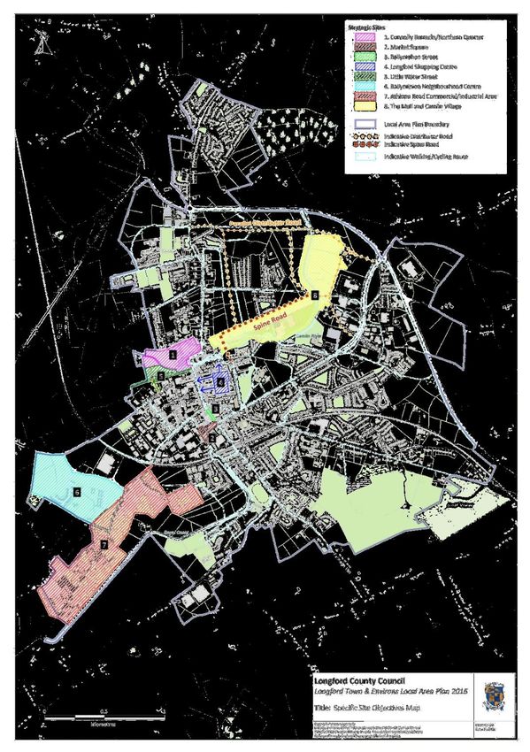
DRAFT Masterplan                                                                                                                               May 2019

Contents
1. Introduction and Terms of Reference ...................................................................................................... 8
   1.1 Context ............................................................................................................................................... 8
       1.1.1 Planning Framework .................................................................................................................... 8
       1.1.2 SEA, AA and Flood Risk Assessment ............................................................................................ 9
       1.1.3 Consultation .............................................................................................................................. 10
   1.2 Vision ................................................................................................................................................ 12
   1.3 Description of Study Area ................................................................................................................. 13
       1.3.1 Land Use Zoning ........................................................................................................................ 14
       1.3.2 Landownership .......................................................................................................................... 16
       1.3.3 Population and Socio Economic Profile ..................................................................................... 17
       1.3.4 Investment and Action to Date ................................................................................................. 20
2. Principles and Priorities .......................................................................................................................... 21
3. Indicative Land Use Options ................................................................................................................... 22
   4.1 Flood Risk.......................................................................................................................................... 22
   3.2 Residential Consolidation ................................................................................................................. 24
   3.3 Flagship Development ...................................................................................................................... 27
   3.4 Community and Amenity, sustainable and renewable uses ............................................................ 29
   3.5 Recreation, Amenity, Biodiversity and Environment. ...................................................................... 31
   3.6 Community Facilities ........................................................................................................................ 36
   3.7 Existing Commercial/Industrial and Logistics Park ........................................................................... 38
   3.8 Agricultural Land............................................................................................................................... 40
   3.9 Strategic Links ................................................................................................................................... 42
4. Implementation and Delivery ................................................................................................................. 45
   4.1 Short/ Medium-Term ....................................................................................................................... 45
   4.2 Medium to Longer Term................................................................................................................... 46
5. Monitoring and Review ......................................................................................................................... 48
Appendix 1 .................................................................................................................................................. 49
   Zoning provisions from Longford Town and Environs Local Area Plan 2016-2022 ................................ 49
Appendix 2 .................................................................................................................................................. 57
   Indicative Projects and Development Options ....................................................................................... 57
       Adaptable lifetime neighbourhood centre ......................................................................................... 58
       Renewable Energy Park and sustainable innovation and research centre ........................................ 60
       Western gateway Amenity Park and Ecological Centre ..................................................................... 64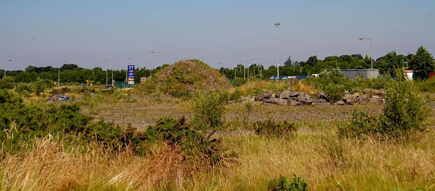
DRAFT Masterplan                                                                                                                              May 2019

Appendix 3 .................................................................................................................................................. 68
   Strategic Environmental Assessment and Appropriate Assessment ..................................................... 68
Appendix 4 .................................................................................................................................................. 71
   Extract from Camlin Flood Study integrated report 2011 (Draft) .......................................................... 71
DRAFT Masterplan                                                                          May 2019

It should be noted that this Regeneration Masterplan does not propose to alter existing
land zonings or rezone lands in the area. Current zonings are as set out in the Longford
County Development Plan 2015-2021 and reiterated by character areas defined in
Longford Town and Environs Local Area Plan 2016-2022. Potential uses referred to in
this document are indicative only and fall within the provisions of the current statutory
land-use framework.

GLOSSARY

LTELAP – Longford Town and Environs Local Area Plan, 2016 -2022

CDP – Longford County Development Plan 2015-2021

LECP – Local Economic and Community Plan

NPF – National Planning Framework, which, along with the National Development Plan (NDP) forms
Project Ireland 2040

RSES – Regional Spatial and Economic Strategy, currently in Draft form

EMRA – Eastern and Midlands Regional Assembly – Longford County is within this region

TII – Transport Infrastructure Ireland

EPA – Environmental Protection Agency

SFRA, SEA, AA – These are assessments, (Strategic Flood Risk Assessment, Strategic Environmental
Assessment, Appropriate Assessment – also Habitats Directive Assessment) carried out on plans and
programmes to identify potential impact on flood risk, the environment and NATURA 2000 sites
respectively and incorporate the relevant provisions to address same in the development of policy,
objectives and the implementation of task and actions as appropriate.

URDF, RRDF, CAF, ORIS, REDZ ,– Funding streams - Urban Regeneration and Development Fund, Rural
Regeneration and Development Fund, Climate Action Fund (these three are under Ireland 2040 for
progression of strategic outcomes), Outdoor Recreational Infrastructure Scheme, Regional Economic
Development Zone.
DRAFT Masterplan                                                                               May 2019

EXECUTIVE SUMMARY

Section 1 of the Masterplan looks at its content purpose and remit, which is essentially to start a
dialogue on the development of the Ballyminion area, why this needs to happen and the policy context
within which proposed development will take place. The processes carried out to date are outlined in
terms of consultation, engagement and assessment and how these have shaped the direction of the
document. The description of the area includes its spatial attributes, landownership and socio-economic
profile.

Following initial consultation with landowners, community representatives and the public, the following
recommendations arise, outlined hereunder, with potential next steps addressed in the sections that
follow.

•   Consolidation (housing and neighbourhood centre) required to allow area to develop in an
    organic way with minimal intervention
       The current housing area in Gleann Riada originally formed part of a larger development that
       was to contain supporting services such as crèche and neighbourhood level shopping. This was
       not completed due to the effects of the economic downturn and resulted in the construction of
       an estate on the fringe of the urban area without the necessary supporting neighbourhood level
       services to sustain it. The current zoning in the area provides for residential consolidation and is
       discussed further in the following sections. This should also be addressed in the context of the
       socio-economic profile of the area outlined above. The potential for specialised housing
       provision in the area combined with access to the necessary community and medical support
       services in the adjacent medical park could be considered as a way forward in this context.

•   Ongoing discussions with developers in the context of proposals contained within this plan,
    working within existing zoning framework
       The potential uses (within the provisions of the current statutory plan) in each area outlined in
       the following sections will be progressed with the engagement of the relevant landowners in
       line with the existing land-use zoning framework provided by the LTELAP, and, in particular, the
       flood constraint provision therein.

        These will include potential opportunities relating to the implementation of the housing action
        plan, amenity development in the context of the integrated action plan adopted for Longford
        under the URBACT scheme and possible requirements of the action plan for jobs, with specific
        potential for application in relation to a flagship proposal.

        Proposals will also address climate change mitigation and adaptation policy where possible in
        the context of the promotion of low carbon and energy efficiency initiatives, sustainable
        transport provision and potential flood risk amelioration.

        Landowners will be incentivised where possible to develop their lands, however, Longford
        County Council will exercise their powers as appropriate to prevent unauthorised dumping and
        occupation, vacancy, dereliction and issues of public health and safety.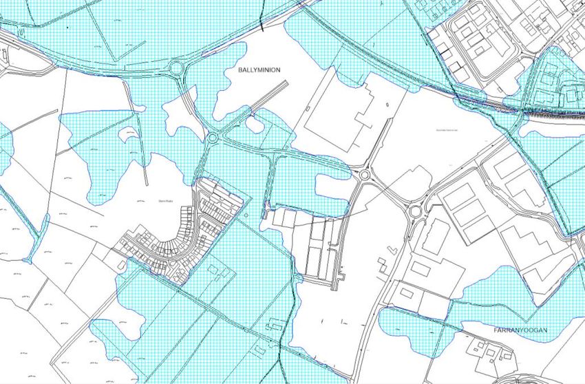
DRAFT Masterplan                                                                             May 2019

•   Flood constraint zoning, amenity requirements, visual considerations – balance of landowner
    obligations and incentives
        All of the landholdings affected by the flood constraint zoning (with the exception of the
        agricultural land) have areas where development may be appropriate subject to the required
        studies and assessment. These are highlighted on the map and will be progressed in detailed
        discussions with landowners.

        Longford County Council acknowledges the effects of the economic downturn on land
        development in the area, however, the situation where boundaries remain unsecured
        facilitating ongoing anti-social behaviour and unauthorised dumping and filling of land cannot
        continue unchecked. As such, landholdings where unauthorised dumping of waste has taken
        place will be referred to the environment section for investigation in each instance.

        It is also separately recommended that the area be considered for designation as a
        “regeneration area” which will facilitate the application of the provisions of the Urban
        Regeneration and Housing Act, 2015, which include the Vacant Sites Levy, a dedicated land
        activation mechanism. This will require a variation of the current County Development Plan.

•   Provision of Community and sporting Facilities
       Numerous proposals were made as part of the consultation process for the development of
       community and sporting facilities in the area. These included:

            •      Athletics Facilities
            •      Development of a soccer Pitch
            •      Cricket oval development
            •      Biking and walking trails
            •      Skate Park

        Potentially suitable for development within the flood risk zone, funding will be investigated in
        this regard and proposals discussed as part of negotiations with landowners in the area.

•   Amenity Development
    The extensive flood risk zone lends itself to the woodland amenity development which will be
    investigated in the context of the “neighbourwood” and other funding schemes. The potential for
    such development to improve the visual amenity of the area from the national road network, to
    create connections between uses and toward the town centre, Canal and other amenity routes and
    to play a role in the enhancement of biodiversity will also be considered.

•   Renewable Energy Proposals
    The area potentially lends itself to the research and development of community energy
    development facilities (developed further in the sections below) for which opportunities exist as
    part of the smart grid proposals under SEAI. In tandem with SEAI and GNI, LCC will develop projects
    that will work toward the implementation of the national transition objective across all target areas
    but particularly in terms of sustainable transport.
DRAFT Masterplan                                                                             May 2019

•   Potential Funding opportunities
    The recommendations contained herein will be progressed in the context of available funding
    opportunities under specific initiatives. These will include investigation under the following
    initiatives:

    •    Project Ireland 2040 funding streams – Urban and Rural Regeneration and Development
         Funds, Climate Action fund
    •    Healthy Ireland initiatives in line with Action Plan developed 2018
    •    Coordination with Leader Funding for Mastertech Business Park
    •    Leader funding for community facilities
    •    Alignment with Midlands Action Plan for Jobs initiatives
    •    SEAI funding streams – energy efficiency, low carbon alternatives, community energy
         development and renewable energy proposals
    •    Community and sporting facilities – National Lottery, Neighbourwood amenity scheme,
         Sports partnership

    The plan then sets out short, medium and long-term options for implementation, along with
    monitoring and review provisions. The appendices that follow outline in detail the current
    statutory land-use zoning provisions (Appendix 1) and indicative options with regard to potential
    development (Appendix 2).
DRAFT Regeneration Masterplan                                                              May 2019

1. Introduction and Terms of Reference
This draft introduces a new dialogue on regeneration and redevelopment in the western environs of
Longford Town. Representing a coordinated approach across economic, social and environmental
regeneration pillars, the masterplan promotes placemaking through integrated land uses, innovation
and community empowerment to achieve a long term sustainable solution to ongoing issues in the
area in line with the provisions of Project Ireland 2040.

                                           National
                                       Regeneration and
                                       development fund

                                        Climate Action
                     NDP/NPF
                                           Funding

                                                                                      Detail
                                         Infrastructural
    Detail

                                           investment

                                           Population
                     RPG/RSES             /Settlement
                                            hierarchy

                                        LongfordTown
                     CDP/LECP
                                           Priority

                                                                  Ballyminion
                                            Strategic
                      LTELAP
                                       sites/Masterplans
                                                                 Regeneration
                                                                  Masterplan

Figure 1 - Context

The plan attempts to reconcile traditional planning approaches with the regeneration concept and is
therefore laid out in terms of compatible and complementary uses within the current planning
framework for areas of the site, followed by an outline of each use and its potential application
across the regeneration pillars. Examples of potential projects are proposed and appropriate
funding streams identified in this context to further progress these opportunities as they arise
(Appendix 2).

1.1 Context
See figure 1

1.1.1 Planning Framework
Broad concepts from the national planning framework, including guidance from the draft EMRA RSES
have been used to guide the formulation of this draft in the context of the existing County
Development Plan and Longford Town and Environs LAP. In particular, the plan anticipates the
potential for rural Local Authorities to act with greater certainty and enhanced powers in the
regeneration sphere.

                                                 [8]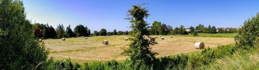
DRAFT Regeneration Masterplan                                                                                                     May 2019

The need for a masterplan for the Ballyminion/Athlone Road area is set out under the Longford
Town and Environs Local Area Plan, as adopted by Longford County Council in September 2016.
These were identified under the eight strategic sites that would, if appropriately promoted, have the
potential to positively impact on the overall development of Longford town into the future.

This draft masterplan follows the planning context as set out in the existing hierarchy, making it
relevant at a local, implementation level (see Figure 1). The future development of the site in the
context of its form and function within Longford Town, requires coordination both spatially and
cross-departmentally to address issues and develop a joint approach to site resolution, while
targeting maximum funding potential in line with the implementation provisions at Section 5 of the
Longford Town and Environs Local Area Plan (LTELAP). Effective engagement with landowners,
elected members and the community is central to the success of the regeneration project.

This draft has also considered the actions contained in the Local Economic and Community Plan and
has aligned proposals with these where relevant.

1.1.2 SEA, AA and Flood Risk Assessment
Relevant assessments of the broad planning provisions of this area have been addressed in the CDP
and the LTELAP. Statutory screening processes have been carried out under the provisions of the
relevant legislation1 and feedback from the Environmental and prescribed authorities received as
part of this process has been included in the current document. Screening documents and
conclusion statements are contained at Appendix 3.

Detailed and specific assessments will be required at an individual project level. In this regard,
objective ENV2 of the LTELAP states the following:

            “OBJ ENV 2: Longford County Council will contribute towards compliance with relevant EU
            Environmental Directives and applicable National Legislation, Policies, Plans and
            Guidelines2.”

1
   S.I. 435/2004 – European Communities (environmental assessment of certain plans and programmes) regulations 2004
Article 6(3) and 6(4) of the Council directive 92/43/EEC on the conservation of natural habitats and of wild fauna and flora, as amended by
Council Directive 97/62/EC
2 including the following and any updated/superseding documents outlined hereunder:

    • EU Directives, including the Habitats Directive (92/43/EEC, as amended)[1], the Birds Directive (2009/147/EC)[2], the Environmental
      Liability Directive (2004/35/EC)[3], the Environmental Impact Assessment Directive (85/337/EEC, as amended), the Water Framework
      Directive (2000/60/EC) and the Strategic Environmental Assessment Directive (2001/42/EC).
    • National legislation, including the Wildlife Act 1976[4], the European Communities (Environmental Impact Assessment) Regulations
      1989 (SI No. 349 of 1989) (as amended), the Wildlife (Amendment) Act 2000, the European Union (Water Policy) Regulations 2003
    • (as amended), the Planning and Development Act 2000 (as amended), the European Communities (Birds and Natural Habitats)
      Regulations 2011 (SI No. 477 of 2011) and the European Communities (Environmental Liability) Regulations 2008[5].
    • National policy guidelines (including any clarifying Circulars or superseding versions of same), including the Landscape and Landscape
      Assessment Draft Guidelines 2000, the Environmental Impact Assessment Sub-Threshold Development Guidelines 2003, Strategic
      Environmental Assessment Guidelines 2004 and the Appropriate Assessment Guidance 2010.
    • Catchment and water resource management Plans, including the relevant River Basin Management Plan.
    • Biodiversity Plans and guidelines, including Actions for Biodiversity 2011-2016: Ireland’s 2nd National Biodiversity Plan (including any
      superseding version of same).
    • Ireland’s Environment 2016 (EPA, 2016, including any superseding versions of same), and to make provision where appropriate to
      address the report’s goals and challenges.

                                                                     [9]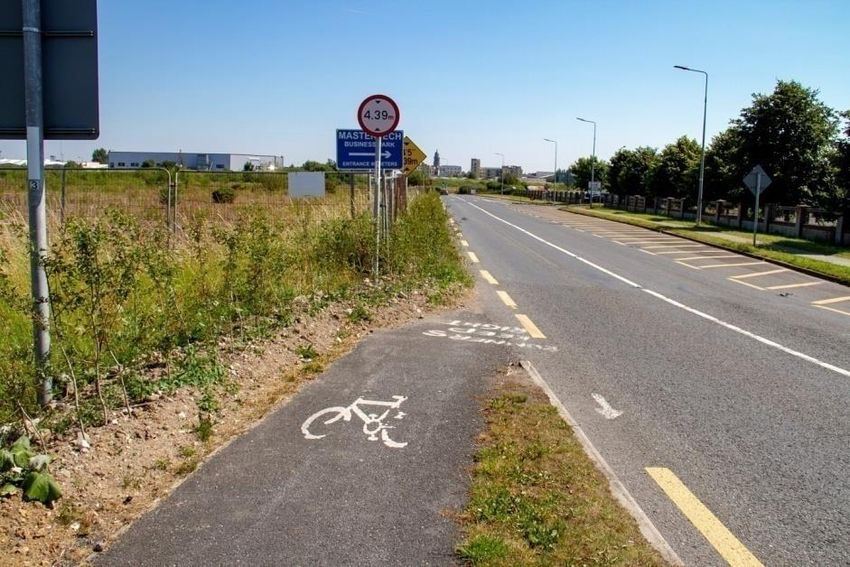
DRAFT Regeneration Masterplan                                                                                          May 2019

1.1.3 Consultation
The plan concept was presented to the Municipal district in March 2018, followed by the strategic
policy committee in May 2018. Feedback was incorporated from these groups into the issues papers
circulated for internal discussion. Other studies, reports and funding applications have also fed into
this masterplan preparation and are referenced throughout.

Working Group
An internal inter-directorate working group was established in May 2018. Feedback and comments
received have been incorporated into this document on the basis of issues papers presented.
Meetings were held in June and July 2018 in anticipation of the first consultation phase3.

Landowners
There is a complex landownership pattern in the area at present (See Fig. 6). All landowners within
were identified and contacted, resulting in some positive discussions on the future of the area,
others that have yet to engage with the process.

This approach has informed the suite of recommendations accompanying this plan. The following
are some of the main issues raised:

     •    Land Assembly
     •    Security of properties/ boundary maintenance
     •    State of repair of access roads, lighting footpaths etc. – taking in charge
     •    Flood risk
     •    Unauthorised occupation of lands
     •    Anti-social behaviour
     •    Dumping of domestic and C&D waste
     •    Housing, industrial/commercial and community facilities

Each landowner was advised in writing and at the time of meeting that discussions did not
constitute pre-planning advice and that they must engage with the Planning Section in order to
avail of the formal advice process.

3
 Working Group Members - Aoife Moore; Michael Nevin; Mairead Ni Chonghaile; Lorraine O'Connor; Louise Kiernan; Con Diffley; Eamonn
Bennett; Brian McNeela; Brian Ross; Sonia Flynn; Terry Rooney; Ciaran Murphy; Marguerite Donohoe; Declan Kilcline; Orla Maguire;
Sheila Healy; Donall Mac An Bheatha; Aileen O'Brien; Sylvia Smith

                                                              [10]
DRAFT Regeneration Masterplan May 2019
Public Consultation Day
A successful open day was held in
Longford Library on the 1st October
utilising methodology developed from a
range of best practice examples4. This
resulted in successful engagement with
a wide variety of stakeholders, resulting
in a wide range of positive and
constructive contributions.
Regeneration Seminar
A regeneration seminar was held in the Hotel Westport on 2nd
November 2018 with the elected members, Management Team,
Regeneration Unit and members of Mayo County Council who
outlined their progress in greenway development, sports tourism
and Ballina Urban regeneration. The regeneration unit outlined
progress to date on a number of projects and funding initiatives.
Work to date on the Ballyminion Masterplan, including initial
actions arising, were presented and well received with useful
feedback incorporated into the pre-draft document.
Community Stakeholders
The regeneration unit have communicated with LCRL in the
context of community stakeholders in the area who have
expressed an interest in working with the masterplan process to
engage residents in the area and pursue the potential of the
application of SICAP funding to further progress social inclusion
initiatives in Gleann Riada.
Several sporting groups were represented at the open day in October. Longford Tidy Towns have
also engaged with the process and have made a detailed submission on potential improvements and
initiatives in the Ballyminion/Athlone Road area from their perspective.
4
Participative planning methods (URBACT), Consultation principles and practice (Department of Public Expenditure and
Reform)
[11]DRAFT Masterplan May 2019
1.2 Vision
The vision for masterplan development is set by the adopted LAP, in strategic sites 6 & 7 relating to
the Ballyminion and Athlone Road Areas, the specific development objectives for which have been
distilled and summarised in Box 1
Box 1 - Vision:
“Instil a sense of pride in the residents and landowners
of Ballyminion/Athlone Road and the greater Longford
area, through core placemaking initiatives that will
promote future investment through the implementation
of appropriate, tailored and prioritised social, economic
and environmental policies and objectives”
Figure 2 – Context – Strategic Sites and Vision
[12]DRAFT Masterplan May 2019
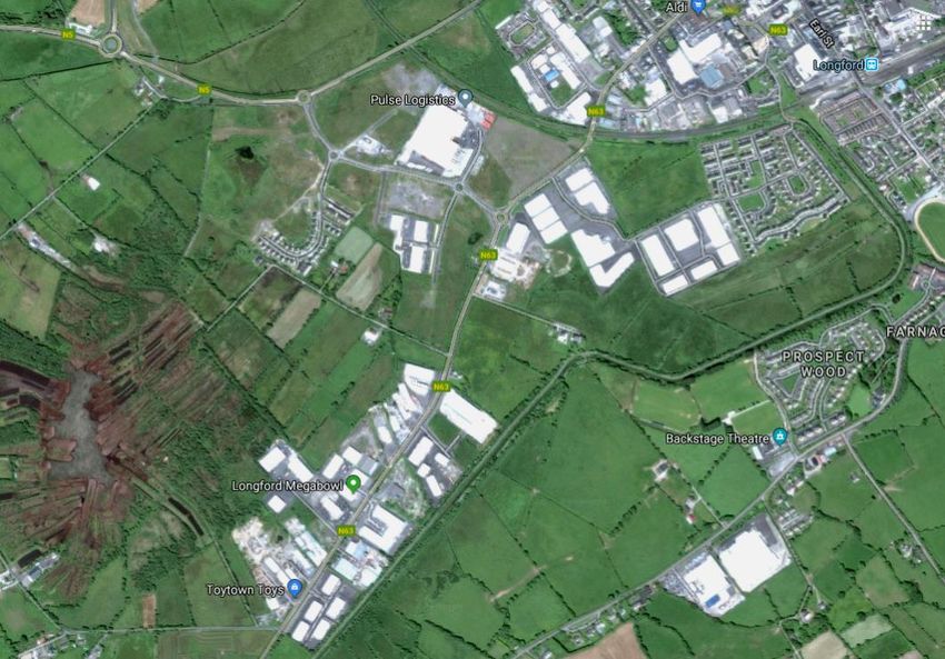
1.3 Description of Study Area
The Ballyminion area is located to the
southwest of Longford town, bounded to
the north by the N5, the N63 to the
south, railway line to the east and an
existing local lane to the west. The area is
primarily zoned for site resolution under
the current CDP and LAP for the area but
also takes in Commercial-Industrial and
industrial lands. Designated primarily as
strategic site 6 in the LAP, this plan will
also look at the surrounding areas and
the potential for synergies with strategic Figure 3 – Masterplan Location Longford Town
site 7 (Athlone Road) in particular.
There is a diversity of existing land uses on the site. The area is visually dominated by the extensive
derelict lands where construction has commenced and/or where construction waste is apparent.
The large scale structure that houses Pulse Logistics (formerly Flancare) combined with the extent of
poorly maintained open spaces, sets a visual scale that is at odds with the residential estate creating
an isolated “island” effect that is reinforced by the lack of any physical or visual connectivity with the
town or other similar scale uses.
Figure 4 – Ballyminion, Athlone Road and Environs
[13]DRAFT Masterplan May 2019
The site is bisected by a link between the two national roads that may be considered by TII at a
future date, essentially serving as the Town’s southern bypass. The strategic nature of this link in its
national and regional context and the fact that it serves as an alternative route for HGV’s that cannot
navigate under the railway bridge on the N63, combined with the position of Pulse logistics and
Corrib Oil on the eastern portion of the site, generate large volumes of heavy traffic and create an
uninviting pedestrian environment. The area has been identified in the Draft Longford Walking and
Cycling Strategy as requiring enhanced links to encourage more sustainable transport patterns.
The Athlone road (N63) adjacent contains predominantly industrial commercial land uses and
presents significant challenges in the creation of coherent and meaningful connections between
areas.
The area is subject to a significant flood risk zone (as per SFRA carried out as part of the LTELAP in
2016) which is a fundamental consideration in the assessment of future detailed land uses.
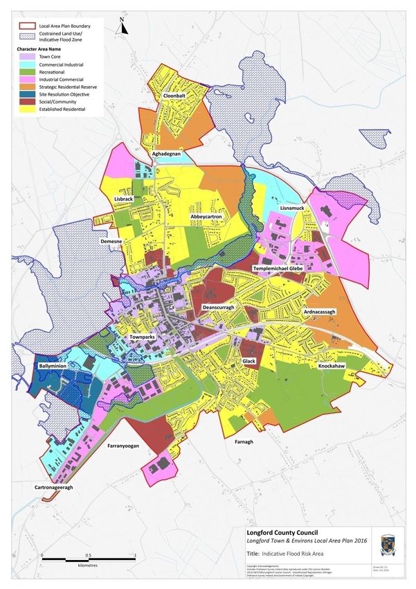
1.3.1 Land Use Zoning
Provisions for the area in the current LTELAP are outlined on the Character area map (Figure 5)
hereunder and illustrate the extent of the flood constraint zoning. In areas outside of this, the
provisions are made in the relevant areas for policies and objectives and broad use classes upon
which the recommendations within this plan have been based. Full details are included at Appendix
1.
[14]DRAFT Masterplan May 2019
Figure 5 – LTELAP Character Area Map (See Appendix 1 for current land-use zoning provisions)
[15]DRAFT Masterplan May 2019
In addition to these zoning provisions, the LTELAP contains the policies objectives specific to the site
resolution character area (see Appendix 1).
1.3.2 Landownership
Landownership in the area is complex (see Figure 6) compounded by the fallout from the economic
downturn with many sites in receivership. This has implications for implementation of proposed
projects in the context of land assembly, service provision etc, however it is anticipated these issues
can be addressed through ongoing direct consultation.
Figure 6 – Ballyminion Landownership Pattern
[16]DRAFT Masterplan May 2019
1.3.3 Population and Socio Economic Profile
The following sections build a profile of the Ballyminion Area, illustrating a snapshot of the plan
population change and composition over the 2011 and 2016 census5. The plan area is wholly
contained within one statistical unit, readily allowing for comparative analysis with the wider town
area, County and State.
Population and Demography
The chart below illustrates population change over the 2011-2016 period, indicating 10% drop in the
population over the intercensal period in the plan area, relative to increases across the Town,
County and State as a whole.
Table 1
% Population Change 2011-2016
6
4
2
0
-2 Small Area Longford County State
-4 Town
-6
-8
The charts below illustrate a much high lower age dependency rate (0-15 age group) than the town,
county and state, indicating a specific need in the area for educational, amenity, health and childcare
facilities. This ratio has grown in Ballyminion over the six year period while remaining relatively
stable over the other geographical areas, potentially indicating a longer term trend of household
formation in the area that should be accommodated as part of any future planning provisions.
Table 2A Population Age Composition 2011 Table 2B Population Age Composition 2016
100% 100%
90% 90%
80% 80%
70% 70%
60% 60%
50% 50%
40% 40%
30% 30%
20% 20%
10% 10%
0% 0%
Small Area County Town State Small Area County Town State
0-15 16-64 65+ 0-15 16-64 65+
5
All figures from CSO census of population 2011 and 2016
[17]DRAFT Masterplan May 2019
Age related dependency (over 65) is less pronounced in Ballyminion across the wider town area
relative to the county and the state. This could indicate a need for tailored facilities and services that
will allow for a more balanced population structure and facilitate sustainable lifetime
accommodation choices.
The presence of the Primary Care Centre provides a service that could be augmented with other
facilities to deliver critical mass in the area, allowing for the sustainable expansion of other supports
(such as transport and pedestrian/cycleways), creating a much needed natural focus and
neighbourhood centre, addressed in detail in later sections of this plan. Actions proposed in the
Longford Age Strategy have been considered as part of the proposals contained in this plan.
Nationality
The charts below illustrate a much greater degree of diversity in the plan area than the other
geographical areas. The area exhibits a particularly high percentage of non-national population from
outside of the UK and EU, which has implications in terms of available support services and
demographic variability due to external influences. This is also true of the potential impact of Brexit,
given the relatively high percentage of UK nationals resident in the area at the time of the last
census.
Table 3A Nationality 2011 Table 3B Nationality 2016
100% 100%
90% 90%
80% 80%
70% 70%
60% 60%
50% 50%
40% 40%
30% 30%
20% 20%
10% 10%
0% 0%
Irish UK EU ROW Irish Uk EU ROW
Small Area Longford Town County State Small Area Longford Town County State
The findings of the Longford Intercultural Strategy, currently in Draft form, and the actions proposed
on foot of these will be particularly relevant in this regard.
Census data indicates a relatively large average Household size in the Ballyminion Small Area,
reflected in the small number of one-person households, relative to the other geographical units.
[18]DRAFT Masterplan May 2019
Table 4A Average HHLD Size Table 4B % one Person HLLDs
3.50 30.00
3.00 25.00
2.50
20.00
2.00
15.00
1.50
10.00
1.00
0.50 5.00
0.00 0.00
Small Area Town County State Small Area Town County State
2011 2016 2011 2016
While these household figures reflect the predominant three-bed semi-detached household type,
they also, when combined with the previous population data, hint at restrictions that house type
homogeneity places on potential for intergenerational diversity and thus, the lack of opportunity for
the housing area to mature.
[19]DRAFT Masterplan May 2019
1.3.4 Investment and Action to Date
Longford County Council has been proactive in securing significant funding under the Town and
Village Renewal scheme, Outdoor Recreational Infrastructure Scheme (ORIS), REDZ Town and Village
Renewal, URDF and other initiatives for the development of amenities in Longford Town.
Investment has been focussed on developing links between the strategic sites identified in the LAP
and promoting footfall through the town through innovative means such as the Healthy Ireland
Initiative.
The area is subject to a large number of planning permissions since 2000, completion of which has
been piecemeal and sporadic since the economic downturn. Bonds were called in as part of the
taking in charge process and the complex landownership profile makes for slow progress in
addressing issues in detail.
The regeneration team have been active on the site developing maintenance strips at pathway
edges and also in the application of rural recreational funding for the Canal Walkway which could act
as an important link into the town from the area. A countywide strategy for walking and cycling is in
the process of development and the Ballyminion area is under consideration as part of this.
The taking in charge team addressed a range of issues in the Gleann Riada housing estate in order to
bring public areas up to standard and within the ownership of Longford County Council. Common
areas were purchased and an incomplete apartment block demolished as part of this process.
Serious subsidence issues with drainage implications were addressed in the public areas.
Longford County Council have taken in charge the link road between the N63 and Strokestown Road,
and a study has been prepared in the context of future proposed works in this area. TII road
improvements in the area include the Farranyoogan Road Improvement Scheme and N63 from
Market Square to Flancare roundabout. A previous study exists (Irish Rail in conjunction with LCC,
1990) on the potential realignment of the N63 under the railway bridge which could provide a basis
for further discussions on strategic links in the area. Three options were assessed in this regard that
would have additional implications for the future development of the site (see Strategic Links).
The Urban and Rural Regeneration funds (URDF/RRDF) were announced in July 2018 to support the
achievement of the national strategic outcomes outlined in Project Ireland 2020. Longford were
successful in securing €1m in the initial phase to develop a number of strategic sites in the urban
area for 2019 and are detailed discussion with the DHPLG in this regard. The potential exists for
future applications under this fund specific to the Ballyminion area and building on other investment
schemes such as the Outdoor Recreational Infrastructure Scheme (ORIS) for which €500,000 funding
was secured for the Royal Canal Walkway in November 2018.
Other action in relation to the site includes investigation into unauthorised Dumping of waste in a
number of areas and unauthorised occupation of others. Compliance with planning permission
granted in relation to landscaping and appearance in a prominent area also under investigation.
These issues have been passed onto the Planning and Environmental Enforcement sections as
appropriate for their review.
[20]DRAFT Masterplan May 2019
2. Principles and Priorities
This Masterplan is centred on an holistic approach to the development of the Ballyminion area and
its environs in the context of its impact on the greater Longford Area and its national and regional
connectivity.
Broad concepts contained within the National Planning Framework have been used to guide and
prioritise proposals within the current policy provisions of the LTELAP.
• Prioritise sustainable movement – pedestrian scale environment, safety and security,
cycleways, public transport
• Residential amenity – including environmental quality, access to services and amenities,
addressing 30% requirement for brownfield development in the urban area (Draft RSES)
• Promote community development, social inclusion, increase quality of life and promote a
sense of identity incorporating the provision of viable neighbourhood level services
• Promote appropriate active use of as much of the area as possible to reduce potential anti-
social behaviour and prevent unauthorised uses and fly-tipping. The flood risk constraint is
acknowledged across a wide area of the site and potential uses such active sports facilities
and associated uses could be considered in this regard.
• Address existing and projected housing list requirements, dereliction and vacancy
• Profile and visual attractiveness – “Western Gateway” - Create an environment that attracts
inward investment
• Acknowledging the strategic nature of the site, enhance relationship to town core and
Athlone road, potential for links toward canal and positive benefits for outlying areas such as
Mastertech business park as a route into Farranyoogan.
• Management of Flood risk, provide for climate change adaptation and mitigation across a
range of sectors and initiatives
The following land use considerations have been prepared on this basis and explore potential
projects across the economic, environmental and social pillars.
Figure 9 illustrates the major provisions of the proposed Masterplan. Uses within the flood risk area
will be governed by the provisions of the constrained land use zoning as defined in the CDP
[21]DRAFT Masterplan May 2019
3. Indicative Land Use Options
Land use provisions are governed by the framework of the LTELAP and CDP
and overlain by the flood constraint illustrated at Figure 8 below. The
schematic at Figure 9 illustrates potential land use provisions proposed in
support of the principles previously outlined.
4.1 Flood Risk
Figure 8 contains current data on flood risk, within which the constrained
land use objective applies (see Appendix 2). Uses in this area shall be of a
nature that does not give rise to additional flooding issues, will not obstruct
important flow paths, will not introduce additional people to flood risk or
entail the storage of hazardous substances. Any applications for proposed
development in these areas shall be accompanied by a site-specific flood risk
assessment. Development may be permitted where demonstrated that it will
have a positive effect in alleviating flooding in the area and wider environs
and in the context of future policy on Climate Change adaptation and
mitigation. In this regard, non-conforming uses may be investigated in terms
of their potential risk and required to relocate/upgrade their facilities under Figure 8 Flood Constraint Zoning (Not to Scale) – areas circled in red above may require particular
the provisions of the relevant legislation6. study as part of flood risk assessments to be carried out at development management stage.
Appendix 4 outlines draft recommendations made as part of the 2011 integrated Camlin Flood
Study.
A series of 6 Draft reports were carried out by consultants for the Camlin
drainage system over the period from 1999 to 2011 and consolidated into an integrated Flood Study by Nicholas O’Dwyer for Longford County Council in 2011.
This study currently remains in draft form and makes a number of recommendations that relate to the Ballyminion Study area (Extract from Draft report Appendix
4). Flood Risk assessment for proposed development should be cognisant of updated recommendations once available and of the Shannon CFRAM provisions7 as
part of the development management process.
6
National Planning Framework, national policy objective 57
7
www.floodinfo.ie
[22]DRAFT Masterplan May 2019
Flood Constraint
Zone
Commercial
industrial
Residential
Amenity
Social/Community
and Neighbourhood
facilities
Existing Pulse
Logistics
Flagship
Corrib Oil
Figure 9 (Not to Scale) - Flood Risk, Existing and Indicative Uses (Subject to planning permission and relevant assessments)DRAFT Masterplan May 2019
3.2 Residential Consolidation
It is considered that additional residential development may be appropriate (within the provisions of the core
strategy of the current CDP) to:
• Consolidate the existing housing estate at Gleann Riada and improve residential amenity
• Increase the feasibility of the provision of neighbourhood, community and amenity facilities, including
public open space.
• Align with LEADER and potential application of the SICAP programme to address social inclusion issues
• Align with the Housing Action Plan and address brownfield development commitments
• Address the derelict and vacant state of the adjacent lands
• Increase the feasibility of neighbourhood level service provision and sustainable transport in the area
• Support the Provision of lifetime adaptable homes that can accommodate the changing needs of a
household over time8 and facilitate the consolidation and diversification of communities
• Progress climate action policies
Design considerations of any proposed development in this area must reflect the adjacent flood risk
designations (area shaded light green below) and proposed developments will contain a risk assessment to
address same.
The Housing section of Longford County Council have outlined deficits in specific accommodation types for
sections of their housing list that could potentially be addressed as part of this development, including assisted
living, sheltered accommodation and lower density, accessible units. The potential for the establishment of a
lifetime adaptable neighbourhood should be considered (See Projects).
Figure 9A Residential Consolidation
8
National Planning Framework NPO 34
[24]DRAFT Masterplan May 2019
Consideration should also be given to the changing demography of the wider area, particularly in terms of
dependency rates, and the community services that exist and/or can be provided to address these needs. This
could include crèches, potential primary/post-primary school sites, outreach facilities, nursing homes/assisted
living and associated services (See Community Facilities).
Each of these uses will also contribute to the activity in the area and reinforce the viability and interaction with
adjacent uses such as the medical park and feasibility of ancillary service to develop a cohesive and vibrant
neighbourhood centre with close links to the step-up services available within the town core.
The implementation of this masterplan will require further engagement with the relevant landowners, approved
housing organisations and the department of housing and planning to ascertain the specifc nature of housing
need in the vicinity to tailor potential development provisions, prevent further vacancy and improve the
amenity of the existing housing area.
The yellow shaded area in Figure 9A takes the existing SFRA carried out at CDP and LTELAP level into account, in
combination with existing and potential uses adjacent. Development proposals should be designed with
reference to the provision of additional community facilities, amenity and open space, visual enhancement of
the area and sustainable connections toward the town core including the potential expansion of the local link
service (see Strategic Links) to encourage sustainable movement in line with recommendations made under the
Healthy Ireland Walking and Cycling Strategy.
View of the Gleann Riada estate from the railway bridge on the Strokestown road, with the
Corrib Oil facility and vacant/derelict land in the foreground.
Improvement of quality of life in the existing Gleann Riada estate is a significant issue that must be addressed at
estate level and for individual dwellings if the masterplan is to succeed. In this regard, future development in
the area must be designed in terms of overall environmental benefit for the residential area as a whole. This
would include appropriate layouts, boundary treatments and landscaping that enhance and protect privacy and
security of existing and proposed houses and minimise potential for anti-social behaviour. Public open space
and amenity development (not requiring built structures or impermeable surfaces) may be carried out within
the flood risk zone adjacent (subject to the relevant assessments). Such development could include the
provision of neighbourhood woods under available funding schemes in tandem with walking and biking trail
provision and other amenity facilities such as the proposed skate park, providing amenities for the residents of
[25]DRAFT Masterplan May 2019
the area and the town itself, while addressing visual considerations from the major road accesses and creating a
buffer between the residential area and commercial uses to the northern side of the site and the rail line.
Longford County Council continue to consult with existing owners, tenants and with the SEAI on the potential
for energy efficiency upgrades and community energy schemes (see Sustainable and Renewable Energy Park) in
tandem with a potential progamme for behavioural change to fulfil obligations in relation to climate change, to
combat fuel poverty and promote residential amenity at an individual level. Discussions are underway with the
relevant agencies investigating the provision of a development worker for the area in this regard. This grass
roots improvement in the quality of the residential environment is essential if future investment is to be
secured, cohesive communities promoted and the requirements of the national transition objective achieved.
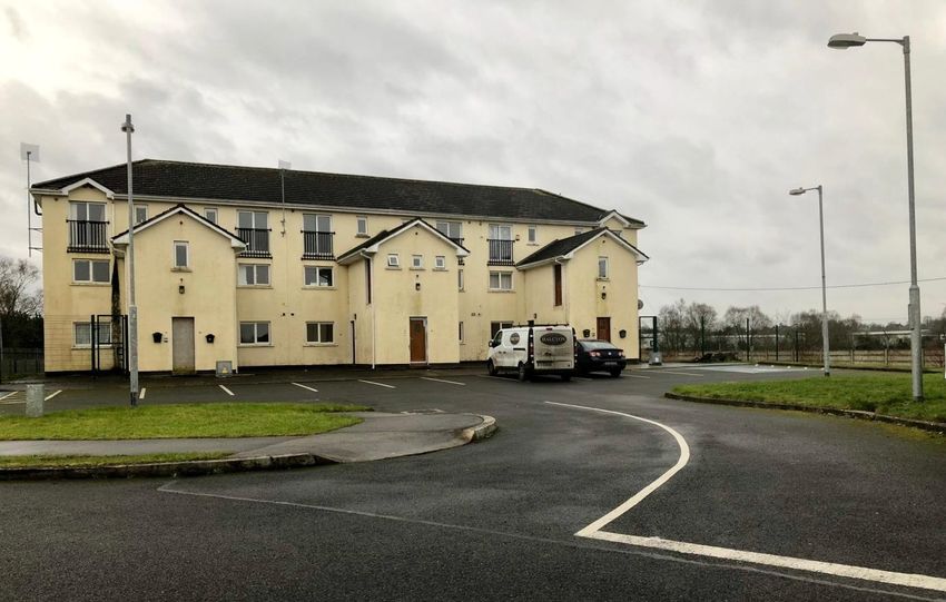
Apartment block, Gleann Riada. Six of these units have been completed by the Housing Section of Longford
County Council under the Repair and Lease Scheme and are now occupied.
Creating a sense of community and addressing social issues will be an important component in ensuring the
ongoing sustainability of this area. In this regard, specific projects will be proposed with associated potential
funding schemes in the areas of community development, Healthy Ireland, flexible and universal design and
combating social exclusion, with reference to the actions contained within the Longford LECP and in
consultation with the relevant agencies. SICAP and other community development resources will be explored in
the context of training schemes that will root proposed projects within the community, promoting ownership,
responsibility and increasing the potential for a successful outcome.
[26]DRAFT Masterplan May 2019
3.3 Flagship Development
The Northern fringe of the site bounding the Strokestown road has a particularly high profile on approaching the
town from the N4/N5 bypass and forms a distinctive impression on this approach. The constrained land use
objective does not apply to the prominent westernmost portion of the site, which provides an opportunity for
the town to “Showcase” itself and create positive, forward thinking image, creating a distinctive “western
gateway” for Longford Town to encourage investment. Care should therefore be taken in this area to ensure
that uses are not established that will undermine the development potential of the masterplan site into the
future.
Such a flagship development would be intrinsically
linked with other potential complementary landuses
such as the provision of appropriate and sustainable
physical connections with the town core,
leisure/amenity and recreational facilities (see also
Projects for longer term potential development
proposals). Such a development would require a
strong visual presence, generate pedestrian activity
throughout the day, contribute to the neighbourhood
facilities available to the adjacent residential area
while serving as a link between the residential and
commercial/industrial/logistics uses in the vicinity.
The location of a hotel with restaurant/cafe, leisure
centre and conferencing facilities could serve this
purpose, should this address economic viability
issues. Figure 9B Flagship Development
Equally, consideration should be given to innovative projects such as the EU LIFE funded discovery centre9 in
Ballymun which would have the added value of potentially linking with social inclusion projects in outlying
residential areas and a renewable energy park on the lands that are subject to the constrained land use
objective (see Flood Risk and Projects). Such a building would require a high standard of architectural design to
create a strong visual gateway to the town.
View of Flagship Site approaching on Strokestown Road from the West.
9
http://www.rediscoverycentre.ie/
[27]DRAFT Masterplan May 2019
Alternative uses for this flagship site could be associated with renewable energy development, energy efficiency
promotion and community/district heating and energy generation, development, research and training10. This is
in line with submissions made under the consultation process that included suggestions for an apprentice
training centre with accommodation onsite. Further potential uses are discussed in Appendix 1 under
Renewable Energy Park.
While high profile and visibility are required of development in this location, vehicular access would most likely
be off the link road roundabout. This aspect and the required pedestrian and cycle routes will be addressed as
part of Strategic links.
10
National Planning Framework national policy objective 55
[28]DRAFT Masterplan May 2019
3.4 Community and Amenity, sustainable and renewable uses
A large area of the vacant landbank to the west of the site is subject to flood risk and contained within the
constrained land use zoning.
Figure 9C Community and Amenity, Sustainable and Renewable Uses
Located adjacent to a wide range of uses in the vicinity, many of which are substantial energy users, this
represents the opportunity for the development of a sustainable/renewable energy research and innovation
centre, potentially in tandem with the proposed flagship use that, with the appropriate supports, could make
environmental social and economic contribution to the south western town environs (subject to appropriate
flood risk assessments – structures and/or impermeable surfaces not proposed in flood risk area).
Longford County Council will consult with the SEAI, GNI, LEADER, SICAP and LEO on the potential for a large
scale innovation park focussing on sustainable and renewable technologies across the areas of energy
generation, storage, distribution, along with hot water, heating and transport at district and community levels
based on best practice models throughout Ireland and Europe. This will also include consultation on the
potential for more sustainable fuel use in the transport sector in particular through the use of Natural Gas, with
potential for Compressed Natural Gas stations, on site CHP electricity generation and biogas injection points.
[29]DRAFT Masterplan May 2019
Existing unfinished roadway constructed on the northern fringe of the Masterplan area, parallel to the Strokestown Road.
View across lands subject to flooding, towards the Gleann Riada Estate .
Potential exists for relationships with the proposed flagship development, recreation and amenity areas in
terms of biomass/fuel development, community allotments and training/development programmes. Uses with
heavy energy requirements and potential for CHP/sustainable energy generation such as data centres could also
be considered in this context (see existing commercial/logistics park). Considerations for development in this
area will include the potential contribution of the project to the achievement of the national transition objective
in terms of climate change adaptation and mitigation in accordance with existing and upcoming policy
frameworks.
Other appropriate uses in the area that align with the existing zoning provisions include the development of
allotments and community gardens, uses that were highlighted during initial public consultation. The potential is
currently being explored for the employment of a dedicated development worker for the area that could help
progress these projects under the SICAP initiative and would work in tandem with the recreational and
biodiversity proposals put forward in the following section.
[30]DRAFT Masterplan May 2019
3.5 Recreation, Amenity, Biodiversity and Environment.
Potential exists for the expansion of recreational amenity in the area, working in tandem with the proposed use
mix and its associated needs and requirements. Passive recreational facilities such as woodland trails and walks,
wildflower gardens and wilderness/wetlands areas can be carefully designed to address the appearance of the
area on approach areas and reduce the sense of isolation and exposure for pedestrians and cyclists using routes
to and from the town core, the canal and adjacent employment areas on the Athlone Road.
Figure 9D Recreation, Amenity, Biodiversity and Environment
Active recreational facilities, if established, would draw younger age cohorts to the area and address vibrance
and movement, enhancing security and increasing feasibility of neighbourhood level facilities. This category
could include Athletics and gymnastic facilities, a skate park (an action contained in the Longford Integrated
Action Plan11, which could also provide benefits in terms of flood attenuation subject to assessment and design)
and urban challenge biking trail, along with more mainstream sporting facilities such as Astroturf pitches,
Athletics and cricket facilities. The provision of supervised community allotments/market gardening could also
provide opportunities to develop community ownership in tandem with orderly presentation of the lands in
question (see Projects for potential development in the area). Biodiversity enhancement in connection with
playground provision and sensory gardens catering for the elderly and those with special needs would provide
an important “bridge” between the residential and medical facilities on-site.
11
Integrated Action Plan for Connolly Barracks and the Northern Quarter of Longford Town produced as part of the URBACT III MAPs Project, launched
June 2018.
[31]DRAFT Masterplan May 2019
Green infrastructure12 is an important consideration in the design of spaces and developments into the future,
addressing the interaction between development requirements and the capacity of the environment to receive
them. Potential exists to increase environmental capacity in some areas through careful consideration of
biodiversity, natural capital and ecosystem services in others. This is particularly relevant given the size of the
Ballyminion site resolution area, the flood risk considerations involved and the potential for the development of
this area to enhance the environmental capacity of Longford Town as a whole, should integrated planning be
incorporated at this early stage. Potential for biodiversity enhancement, alignment with national pollinator
initiatives and connections to the Royal Canal were issues raised at initial consultation stage.
The photo above illustrates the view from the N63 looking north toward the primary care centre across the
vacant landbank that has since reverted to a series of natural wetlands. The potential green infrastructure
role of reverted areas such as these and their potential positively contribute to areas such as climate change
adaptation (eg. attenuation) visual amenity and biodiversity reserves will be investigated as part of the
overall masterplan implementation and delivery.
There is evidence of Japanese Knotweed in this area, which is currently being treated by Longford County
Council Environment section. The remainder of the site will be surveyed for invasive species and the eradication
of such species where found will be a material consideration in the progression of future development
proposals on site.
12
National Planning Framework NPO 58
[32]DRAFT Masterplan May 2019
The above illustration outlines the constrained land use objective with the current extent of derelict and vacant
land in the context of the plan area. Restrictions on development within the flood zone have been carefully
considered in the proposals contained within this masterplan.
View of the eastern side of the central roundabout at the entrance to the Pulse Logistics facility. Poorly maintained
boundaries, construction waste and debris, discontinuous footpaths and large scale lighting fixtures create a hostile
environment for the pedestrian and a poor visual impression.
[33]You can also read