Essex Thames Gateway Water Cycle Study - Scoping Study
←
→
Page content transcription
If your browser does not render page correctly, please read the page content below
Essex Thames Gateway

Essex Thames Gateway Water Cycle
Study
Scoping Study

Final Report
March 2009

                                               Prepared for:
                                 Basildon District Council,
                            Castle Point Borough Council,
                                Rochford District Council,
                       Southend-on-Sea Borough Council,
                                    Essex County Council
Essex Thames Gateway Planning Authorities
Water Cycle Study – Scoping Study

Revision Schedule

Essex Thames Gateway Water Cycle Study – Scoping Report
March 2009

 Rev          Date                   Details                    Prepared by                     Reviewed by                 Approved by

   01         January 2009           Draft Scoping              Mary Pyne                       Carl Pelling                Jon Robinson
                                     Report                     Assistant Water Specialist      Senior Consultant - Water   Associate

   02         March 2009             Final Scoping              Mary Pyne                       Carl Pelling                Jon Robinson
                                     report                     Assistant Water Specialist      Senior Consultant - Water   Associate

                                                                                                                                          Scott Wilson
                                                                                                                                           Scott House
                                                                                                                                          Alençon Link
                                                                                                                                           Basingstoke
 This document has been prepared in accordance with the scope of Scott Wilson's
                                                                                                                                            RG21 7PP
 appointment with its client and is subject to the terms of that appointment. It is addressed
 to and for the sole and confidential use and reliance of Scott Wilson's client. Scott Wilson
 accepts no liability for any use of this document other than by its client and only for the                                     Tel: 01256 310200
 purposes for which it was prepared and provided. No person other than the client may
 copy (in whole or in part) use or rely on the contents of this document, without the prior
                                                                                                                                 Fax: 01256 310201
 written permission of the Company Secretary of Scott Wilson Ltd. Any advice, opinions,
 or recommendations within this document should be read and relied upon only in the
 context of the document as a whole. The contents of this document do not provide legal
 or tax advice or opinion.
                                                                                                                             www.scottwilson.com
 © Scott Wilson Ltd 2008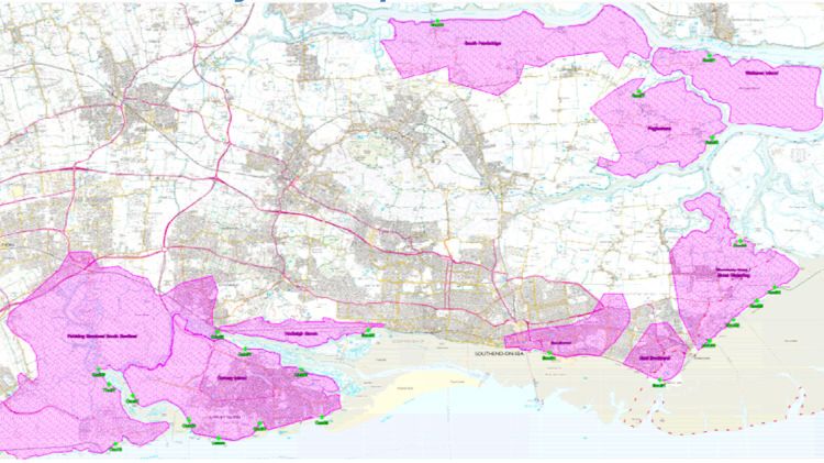
Essex Thames Gateway Planning Authorities
Water Cycle Study – Scoping Study

Table of Contents

1         Executive Summary .......................................................................... 4
1.1       Introduction.....................................................................................................................4
1.2       Water Resources & Supply .............................................................................................4
1.3       Waste Water Treatment, Collection and Water Quality ...................................................5
1.4       Ecology and Baseline Biodiversity. .................................................................................5
1.5       Surface Water Management ...........................................................................................6
1.6       Study area for WCS next phase......................................................................................6
2         Introduction....................................................................................... 7
2.1       Background.....................................................................................................................7
2.2       Aims and Objectives .......................................................................................................7
3         Essex Thames Gateway Water Cycle Study..................................... 8
3.1       The Water Cycle .............................................................................................................8
3.2       Implications for Development..........................................................................................9
3.3       Stages of a Water Cycle Study .......................................................................................9
3.4       Integration with the Planning System ............................................................................ 12
3.5       Data Availability ............................................................................................................ 12
4         Development in Essex Thames Gateway.........................................13
4.1       The Essex Thames Gateway Area................................................................................ 13
4.2       National, Regional and Local Drivers and Policies ........................................................ 14
4.3       Housing/Employment Development .............................................................................. 20
4.4       Development Areas ...................................................................................................... 20
5         Water Cycle Environment and Infrastructure Baseline .....................22
5.1       Introduction................................................................................................................... 22
5.2       Water Resources .......................................................................................................... 22
5.3       Flood Risk..................................................................................................................... 31
5.4       Wastewater Treatment and Collection .......................................................................... 31
5.5       Water Quality ................................................................................................................ 33
5.6       Ecology and Biodiversity ............................................................................................... 33
5.7       Definition of Study Area ................................................................................................ 34
6         Preliminary Findings, Constraints and Recommendations ...............36
6.1       Water Resources and Supply ....................................................................................... 36
6.2       Flood Risk Management ............................................................................................... 39
6.3       Wastewater Treatment and Collection .......................................................................... 43

Essex Thames Gateway Planning Authorities
Water Cycle Study – Scoping Study

6.4       Water Quality ................................................................................................................ 48
6.5       Biology and Biodiversity ................................................................................................ 48
7         Recommendations...........................................................................50
7.1       Progression of WCS ..................................................................................................... 50
7.2       Project Group/Stakeholder............................................................................................ 50
Appendix A – Data Catalogue.....................................................................51
Appendix B - Surface Water Management Plan Methodology. ...................60
Essex Thames Gateway Planning Authorities
Water Cycle Study – Scoping Study
1 Executive Summary
1.1 Introduction
This Essex Thames Gateway Water Cycle Study Scoping report has undertaken a sub-regional
review of the existing condition of both the natural water environment and the water
infrastructure which serves the population of the South Essex study area.
A significant level of growth and new development is proposed within the planning authority
areas of Basildon District Council, Southend-on-Sea Borough Council, Castle Point Borough
Council and Rochford District Council whose administrative boundaries make up the immediate
study area. This development has the potential to have a negative impact on the water
environment and there is potential for there to be limitations on the capacity of the infrastructure
available to service this new development
This scoping study aims to identify where there are issues and constraints within the water
environment and water infrastructure that requires further consideration in the next phase of the
Water Cycle study. It also defines the extent of the study area, implications from the recent Pitt
review into the 2007 floods and sets the scope of the work required in the next stage of the
study.
1.2 Water Resources & Supply
The following scopes the existing condition with respect to Water Resources and Water supply
infrastructure in the Essex Thames Gateway area and what is require to be addressed in future
stage of the WCS:
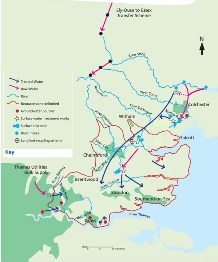
• The Essex Thames Gateway area does not have sufficient raw water resources to
supply existing development. As a result, the area is reliance on transfer of raw and
treated water to the area from the Thames Region and from Norfolk and Suffolk
• This means that there is limited water is available for further abstraction from surface or
groundwater sources and therefore further transfer of water resources will be required
to supply water to new developments within the Essex Thames Gateway area;
• Future water demand is expected to be met through the proposed increase in storage at
Abberton Reservoir and the commensurate increase in abstraction and transfer from the
Ely-Ouse transfer scheme, which if approved will come online in 2014. Until the
scheme is in place and operational, there will be a deficit in available water resources
during drought years in Essex Thames Gateway area
• The next stages of the WCS are required to define how much growth the Abberton
scheme can accommodate, and to identify what water efficiency measures are required
in new and existing development to minimise the impact of additional growth.
Scoping Report March 2009
4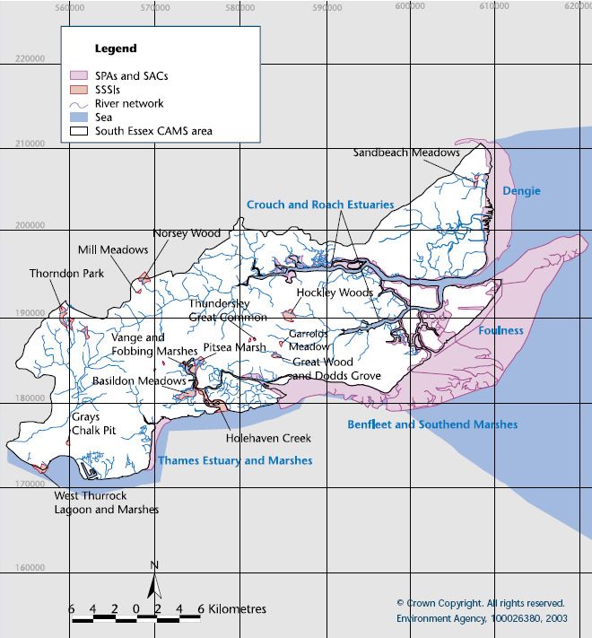
Essex Thames Gateway Planning Authorities
Water Cycle Study – Scoping Study

                 •   There are no immediate limitations on supply infrastructure pipelines, reservoirs, water
                     treatment works or pumping stations. The next stage of the WCS will need to confirm
                     this relative to the location of development options.

1.3       Waste Water Treatment, Collection and Water Quality
            There are several WWTW within the study area that have been assessed and as part of the
            Scoping Study. In each case, the capacity in both the treatment works itself and the sewerage
            network collection system has been described.

            In the majority of cases there is sufficient treatment capacity and capacity in the network to
            allow planned development in the study area up to 2015. Development beyond this in most
            cases will require upgrades to the treatment capacity of several of the WWTW and the
            construction of new strategic sewer mains to service new development; this will need to be
            defined and assessed in the next stage of the WCS.

            Several of the WWTW and future upgrades need to be assessed for the quality of the treated
            wastewater discharges to ensure that there is no deterioration in water quality of the receiving
            watercourses under the Water Framework Directive, the Shellfish Directive and the Bathing
            Waters Directive. The next stage of the WCS will need to consider the consent parameters to
            be applied to increases in discharges at WWTW to ensure no compliance with these directives.

            Water quality of watercourses in the Essex Thames Gateway varies from good to poor. As well
            as wastewater discharges, runoff from development will need to be managed to ensure that
            increases in developed land does not lead to an increase in urban pollution and further impacts
            on water quality. The use of Sustainable urban Drainage Systems (Suds) will need to be
            addressed as part of the next stage of the WCS.

1.4       Ecology and Baseline Biodiversity.
            The Essex Thames Gateway area contains several sites of ecological importance including the
            Essex Estuaries Special Area of Conservation (SAC), Foulness SSSI and Ramsar site; the
            Crouch and Roach SSSI SAC and SPA; and, Benfleet and Southend Marshes SPA; all of
            which have the potential to be impacted upon by development in the study Area. There is
            unlikely to be any increase in existing abstractions from surface or groundwater sources and as
            such it is possible to screen out impacts to the sites within the study area as a result of water
            resources. However, discharges of wastewater still have the potential to impact on these sites
            and this needs to be considered in the next stage of the WCS.

            However, a further sixteen European sites outside of the study area, are considered to have
            links with development as they have the potential to be impacted by increased water demand
            up to and post 2014. The sites associated with the Abberton abstraction and transfer scheme
            will continue to be affected by development in the Essex Thames Gateway area, this will need
            to be investigated further in the next stage of the WCS.

Scoping Report                                                                                     March 2009
                                                       5
Essex Thames Gateway Planning Authorities
Water Cycle Study – Scoping Study

1.5       Surface Water Management
            The management of surface water runoff from new development has the potential to act as a
            constraint to development within the Essex Thames Gateway area, not just because of space
            requirements, but because the requirement for a reduction in runoff rates and volumes is likely
            to be onerous. This would need to be further investigated as part of the outline and detailed
            stages of the WCS to ensure that the appropriate strategic level constraints and mitigation
            measures are identified and that guidance is given to the development of a Surface Water
            Management Plan (SWMP) for each District/Borough as recommended by the recent Pitt
            Report. The WCS and SWMP will also help to ensure that developers address the required
            surface water management issues during preparations of site specific FRAs.

1.6       Study area for WCS next phase
            The Essex Thames Gateway study area encompasses the administrative boundaries of the
            authorities of Southend-on-Sea Borough Council, Rochford District Council, Castle Point
            Borough Council, and Basildon District Council, as well as the Abberton reservoir and the route
            of raw water transfer from Denver. It is important to note that the study area for the catchment
            is wider than the definition of the Thames Gateway South Essex authorities for two reasons.

            Firstly, the Water Cycle Study must consider the water cycle issues for the entire administrative
            boundaries of the local authorities of Basildon and Rochford which are not located entirely
            within the Thames Gateway Growth Area zone.

            Secondly, whilst issues to do with wastewater treatment, transfer and discharge are confined to
            the South Essex authorities and associated ecological sites (, the water resources for the area
            are managed on a wider Essex scale. In addition, the transfer of raw water to the Essex WRZ
            from outside of Essex further increases the consideration of the study area.

            It is recommended that each authority progresses with an Outline WCS based on the preferred
            locations for development. For the case of Basildon District Council, it is considered that a
            ‘Pre-Outline’ study is undertaken where the baseline capacity for water and wastewater
            services infrastructure and water environment is undertaken for the whole district (at a strategic
            level) to inform the selection of preferred development locations.

Scoping Report                                                                                      March 2009
                                                      6
Essex Thames Gateway Planning Authorities
Water Cycle Study – Scoping Study

2         Introduction
2.1       Background
            The Client Group consisting of: South Essex Strategic Planning Authorities of Essex County
            Council and Southend-on-Sea Borough Council; and the Local Planning Authorities of
            Rochford District, Castle Point Borough and Basildon District Councils, require a Scoping
            Report, as a preliminary stage to achieving a South Essex Water Cycle Study (WCS) and a
            review of the Thames Gateway South Essex Strategic Flood Risk Assessment (SFRA) which
            was published in 2006.

            The Essex Thames Gateway Scoping WCS will act as a preliminary stage to achieve a South
            Essex WCS that will provide a sufficient level of detail to inform the emerging Local
            Development Framework (LDF) and the other Local Development Documents for each of the
            client authorities.

            As part of the scoping, the data collection and collation process has been instigated and has
            gathered together relevant information ready for use in the next stage of the study.

2.2       Aims and Objectives
            The overall objective of the main WCS is to produce a study for South Essex that will provide
            an integrated approach to managing flood risk, water supply, and wastewater infrastructure in
            the study area, while being mindful of the environmental constraints. This aims to ensure that
            all the elements of the water cycle and water infrastructure can be addressed as part of the
            delivery of the long term planning provision for growth in the area.

Scoping Report                                                                                  March 2009
                                                    7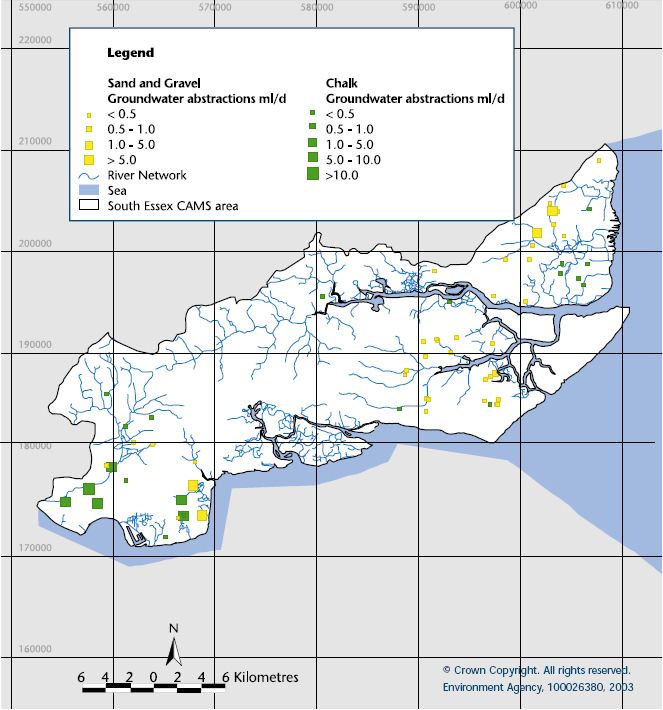
Essex Thames Gateway Planning Authorities
Water Cycle Study – Scoping Study

3          Essex Thames Gateway Water Cycle Study
3.1        The Water Cycle
             In its simplest form, the Water Cycle can be defined as ‘the process by which water is
             continually recycling between the earth’s surface and the atmosphere’. Without considering
             human influences, it is simply the process by which rain falls, and either flows over the earth’s
             surface or is stored (as groundwater, ice or lakes) and is then returned to the atmosphere (via
             evaporation from the sea, the soil, surface water or animal and plant life) ready for the whole
             process to repeat again.

             In the context of this study, the ‘water cycle’ has a broader definition than the simple water or
             ‘hydrological‘ cycle. The human influence on the water cycle introduces many new factors into
             the cycle through the need to abstract water from the natural environment, use it for numerous
             purposes and then return to the natural system. The development and introduction of
             technology such as pipes, pumps, drains, and chemical treatment processes has meant that
             human development has been able to manipulate the natural water cycle to suit its needs and
             to facilitate growth and development. ‘Water Cycle’ in this context is therefore defined as both
             the natural water related environment (such as rivers, wetland ecosystems, aquifers etc), and
             the water infrastructure (hard engineering focused elements such as: water treatment works,
             supply pipelines and pumping stations) which are used by human activity to manipulate the
             cycle.

                                                                                               1
              Figure 3-1 The Water Cycle Study (Source: Environment Agency

1
 Water Cycle Study Manual – Guidance on how to carry out a water cycle study, Environment Agency ( http://www.environment-
agency.gov.uk/research/planning/33368.aspx)

Scoping Report                                                                                                    March 2009
                                                              8
Essex Thames Gateway Planning Authorities
Water Cycle Study – Scoping Study

3.2          Implications for Development
             In directly manipulating elements of the water cycle, man affects many changes to the natural
             water cycle which can often be negative. To facilitate growth and development, there is a
             requirement for clean water supply which is taken from natural sources (often depleting
             groundwater stores or surface systems); the treatment of waste water which has to be returned
             to the system (affecting the quality of receiving waters); and the alteration and management of
             natural surface water flow paths which has implications for flood risk. These impacts can
             indirectly affect ecology which can be dependent on the natural features of a water cycle for
             example wading birds and wetland habitat, or brown trout breeding in a Chalk stream which
             derives much of its flow from groundwater sources.

             In many parts of the UK, some elements of the natural water cycle are considered to be at, or
             close to their limit in terms of how much more they can be manipulated. Further development
             will lead to an increase in demand for water supply and a commensurate increase in the
             requirement for waste water treatment; in addition, flood risk may increase if development is
             not planned for in a strategic manner. The sustainability of the natural elements of the water
             cycle is therefore at risk.

             A WCS is an ideal solution to address this problem. It will ensure that the sustainability of new
             development is considered with respect to the water cycle, and that new water infrastructure
             introduced to facilitate growth is planned for in a strategic manner; in so doing, the WCS can
             ensure that provision of water infrastructure is sufficient such that it maintains a sustainable
             level of manipulation of the natural water cycle.

3.3        Stages of a Water Cycle Study
                                                                    2
             Current guidance on Water Cycle Studies suggests that WCS’s should generally be
             undertaken in three stages, dependent on the status of the various Local Development
             Documents (LDDs), as part of the wider Local Development Framework (LDF), being prepared
             by Local Planning Authorities (LPAs) for submission. In order to determine the requirements of
             future stages of the Essex Thames Gateway WCS in relation to the varying LDF programmes
             for each of the client authorities, a scoping WCS has been undertaken to define the key issues
             for each authority and the sub-region as a whole.

             Figure 3-2 Stages of the Water Cycle Study Process illustrates the three stages of the WCS
             and how they inform planning decisions and documents. This study undertakes the first stage,
             the Scoping Study.

2
 Water Cycle Study Manual – Guidance on how to carry out a water cycle study, Environment Agency ( http://www.environment-
agency.gov.uk/research/planning/33368.aspx)

Scoping Report                                                                                                    March 2009
                                                              9
Essex Thames Gateway Planning Authorities
Water Cycle Study – Scoping Study
Figure 3-2 Stages of the Water Cycle Study Process
Baseline Assessment
data review - Existing condition - key issues Scoping WCS
Capacity Assessment
Water Resources/Supply Wastewater Ecology Water Quality Flood Risk
‘Pre-Outline’ WCS
Water Cycle Outline Option Development
Wastewater Water Supply Water Efficiency Flood Risk Surface Water
Infrastructure Infrastructure Options Management Management Plan
Allocation Scenario
Outline WCS
Assessment
Site specific Infrastructure options
Wastewater Water Supply Water Efficiency Flood Risk Surface Water
Infrastructure Infrastructure Options Management Management Plan
Infrastructure Programme &
Development Phasing
Policy & Developer Guidance Detailed WCS
In some cases, it may be that the progress of the Local Development Framework is such that a
full outline study cannot be completed as preferred options for site allocations are not known.
In such situations, it is considered that a ‘pre-outline’ study can be undertaken that takes the
step of completing the baseline and capacity assessments across a study area to inform the
selection of preferred site allocations. This is indicated in Figure 3-2 above.
Scoping Report March 2009
10Essex Thames Gateway Planning Authorities
Water Cycle Study – Scoping Study
3.3.1 Scoping Water Cycle Study
The scoping study determines the key ‘water-cycle’ areas where development is likely to either
impact on the water environment, or where development is likely to require significant
investment in water infrastructure (i.e. pipes, or treatment) to service it.
Its key purpose is to define whether there are significant constraints that would need further
assessment to determine whether they affect either the locations of allocation options, or the
amount of development that can be provided within an allocation site or spatial location.
It is a high level assessment that looks at area-wide or sub regional issues. The level of
assessment covers whether:
• There is a potential for an area-wide negative supply and demand balance for potable
water i.e. demand is likely to be greater than supply for the sub regional area;
• There are any ecologically sensitive sites that have a hydrological link to development in
the sub region i.e. an SAC wetland site located on a river downstream of discharges from a
wastewater treatment works;
• An area in the sub region has a history of sewer flooding and hence potential restrictions
on new connections from development; and
• Local watercourses have water quality concerns which will be made worse if further
discharge of wastewater from new development occurs.
A scoping study therefore defines the study area and concludes what issues require further
investigation and therefore, what the scope of the Outline Study should be.
3.3.2 Outline and Detailed Water Cycle Studies
Outline Study
The Outline Study considers all of the ways in which new development will impact on the water
environment or water infrastructure specific to where growth is most likely to be targeted. It is
usually undertaken during consideration of allocation sites such that it can inform the decision
process in terms of where development will be targeted for each authority. The key aim of the
Outline Study is to provide Local Planning Authorities (LPAs) with the evidence base which
ensures that water issues have been taken into account when deciding the location and
intensity of development within an authority’s planning area as part of the development of the
Core Strategy. It is also gives the water company an evidence base to its business plans which
determine how much they can charge customers to invest in upgrades and the provision new
infrastructure required to service proposed development.
As previously described, a ‘pre-outline’ study can be undertaken when preferred sites are not
known, This stage would be undertaken before the full Outline Study but develops the Scoping
study outputs further by defining baseline and existing infrastructure and environmental
capacity across a study area, rather than being focused on preferred site allocations. The pre-
outline capacity assessment is undertaken at a high level to provide sufficient detail to inform
planning decisions, but without undertaking abortive detailed work on sites or areas that would
not be taken forward for development.
Scoping Report March 2009
11Essex Thames Gateway Planning Authorities
Water Cycle Study – Scoping Study
It could be that the Outline Study identifies that water cycle issues are not significant, and that
new development can be implemented without significant new investment. If this is the case, a
detailed study may not be required. However, if new infrastructure is required, or an impact on
the water environment cannot be ruled out as insignificant, a detailed water cycle study will
need to be undertaken for site specific allocations, or for the authority as a whole.
Detailed Study
The detailed study can vary significantly in its scope and remit. However, its key purpose is to
define what specific infrastructure and mitigation is required to facilitate development, once the
decisions have been made on the location of allocations. Dependent on the findings of the
Outline Study, there could be the potential requirement to undertake detailed and complex
studies in order to define exactly what infrastructure or mitigation is required to feed into LDF
Infrastructure Plans. The Detailed study should be undertaken in conjunction with the
development of DPDs such as Area Action Plans and should provide the evidence base to site
specific policies in Supplementary Planning Documents (SPDs).
3.4 Integration with the Planning System
As part of the Local Development Framework (LDF) process, Local Planning Authorities (LPAs)
are required to produce evidence based studies which support the selection processes used in
deciding on final growth targets and areas to be promoted for growth. The WCS is one such
example of an evidence-based study which specifically addresses the impact of proposed
growth on the ‘water cycle’.
As part of the Essex Thames Gateway Authorities overall strategy to meet future growth targets
set out in the RSS in a sustainable way, the WCS will make up one of a number of strategic
studies and plans which will form part of the evidence base supporting the production of each
Essex Thames Gateway Authorities’ LDF.
3.5 Data Availability
Undertaking of the Essex Thames Gateway Water Cycle Scoping Study has required a large
amount of data collection, much of which has been reliant on the willingness of third parties to
supply in order to allow the study to be progressed. In some cases, the availability of data with
respect to water cycle infrastructure and future planning has not been available within the time
required to undertake the assessment in the Scoping Study. In such cases, various
assumptions have been used to enable the study to continue. Under each relevant topic, this
report identifies what data has been used in each assessment and identifies where
assumptions have been adopted and the reasoning behind these assumptions.
Recommendations are also made for further, more detailed investigation in the Outline and
Detailed WCS.
A full list of the data requested and that which was made available to the study is included in a
data catalogue and Appendix A. This data catalogue recommends the data required for the
next stage of the WCS, as well as the expected quality and availability of this data and
associated cost (where known).
Scoping Report March 2009
12Essex Thames Gateway Planning Authorities
Water Cycle Study – Scoping Study
4 Development in Essex Thames Gateway
4.1 The Essex Thames Gateway Area
The Essex Thames Gateway area consists of the authorities of Southend-on-Sea Borough
Council, Rochford District Council, Castle Point Borough Council, Basildon District Council and
Thurrock District Council. Due to the advanced nature of Thurrock’s LDF, the council is
progressing a separate WCS. This report therefore addresses the scoping of a WCS for the
remaining Essex Thames Gateway authorities.
The area covered by the Essex Thames Gateway authorities has a mixture of heavily
developed areas and large areas of rural landscape. The heavily developed areas are typically
adjacent to the banks of the River Thames, with land use being mostly either industrial (for
example Tilbury Docks) or high-density residential development (e.g. Southend-on-Sea or
Canvey Island). Rural areas constitute much of the north and east of the study area.
The main watercourse in the area is the Thames Tideway. Other main rivers in the area are the
Rivers Roach and Crouch. The River Crouch flows east from Wickford and then north of
Hullbridge from where it forms the northern boundary of the Rochford District, eventually
issuing to the North Sea at Foulness Point. The River Roach flows east from the town of
Rochford, north of Southend, and joins the River Crouch at Wallasea Island, east of Burnham-
on-Crouch. These watercourses have substantial tidal sources. There are several other smaller
watercourses throughout the study area; however these are predominately tributaries of the
main watercourses identified above. Many of the watercourses in the area form the boundaries
of island landmasses, such as Canvey Island and Foulness Island. Such formations are
particularly prominent in the east of the region where the area is low-lying and dominated by
marshland and wetland.
Some of the key issues in the study area that are of major significance to the development of a
WCS and SFRA are:
• The Thames Estuary is an area increasingly at risk of flooding due to rising sea levels and
increased rainfall intensity associated with the effects of climate change;
• The most significant flood events in the South Essex area are the result of storm surges,
coinciding with high spring tides to produce high tidal water levels that can result in
overtopping or breaching of tidal defences;
• Surface Water management is a concern, with the need to consider the impact of rising sea
levels as a result of climate change on the discharge of surface water runoff to tidal
systems;
• Rising groundwater poses a risk in terms of groundwater flooding, management of surface
water discharge (SuDS), and pollution impacts to waste sites;
• There are capacity issues at several major waste water treatment works (WWTW) within the
Essex Thames Gateway authorities’ administrative areas, and discharges from WWTW
such as Basildon, Rochford, Wickford, Rayleigh East and Southend have implications for
the conformity with the EU Bathing Water and Shellfish Directives.
Scoping Report March 2009
13Essex Thames Gateway Planning Authorities
Water Cycle Study – Scoping Study
4.2 National, Regional and Local Drivers and Policies
The Thames Gateway is an area of national priority for regeneration and has been earmarked
for major development over the next 10 years. With such development come particular
challenges with regard to sustainable development, provision of water and waste-water
services and impacts and influences on flood risk.
4.2.1 National Drivers and Policies
The growth within the Essex Thames Gateway area is driven by regional planning policy, but
any growth and changes to the environment will need to comply with the main EU Directives
and UK legislation and guidance on water as provided in Table 4-1.
Table 4-1 EU Directives and UK Legislation and Guidance on Water
Directive/Legislation/ Description
Guidance
Bathing Waters To protect the health of bathers, and maintain the aesthetic quality of
Directive 76/160/EEC inland and coastal bathing waters. Sets standards for variables, and
includes requirements for monitoring and control measures to comply with
standards.
Shellfish Waters Directive To protect or improve shellfish waters in order to support shellfish life and
growth, therefore contributing to the high quality of shellfish products
directly edible by man. Sets physical, chemical and microbiological water
quality requirements that designated shellfish waters must either comply
with (‘mandatory’ standards) or endeavour to meet (‘guideline’ standards).
Code for Sustainable The Code for Sustainable Homes has been introduced to drive a step-
Homes change in sustainable home building practice, providing a standard for
key elements of design and construction which affect the sustainability of
a new home. It will become the single national standard for sustainable
homes, used by home designers and builders as a guide to development,
and by home-buyers to assist in their choice of home.
It will form the basis for future developments of the Building Regulations in
relation to carbon emissions from, and energy use in homes, therefore
offering greater regulatory certainty to developers.
Environment Act 1995 Sets out the role and responsibility of the Environment Agency.
Environmental Integrated Pollution Control (IPC) system for emissions to air, land and
Protection Act, 1990 water.
Future Water, February Sets out the Government’s vision for water in England in 2030. The
2008 strategy sets out an integrated approach to the sustainable management
of all aspects of the water cycle, from rainfall and drainage, through to
treatment and discharge, focusing on practical ways to achieve the vision
to ensure sustainable use of water. The aim is to ensure sustainable
delivery of water supplies, and help improve the water environment for
future generations.
Scoping Report March 2009
14Essex Thames Gateway Planning Authorities
Water Cycle Study – Scoping Study
Directive/Legislation/ Description
Guidance
Groundwater Directive To protect groundwater against pollution by ‘List 1 and 2’ Dangerous
80/68/EEC Substances.
Making Space for Water, Outlines the Government strategy for the next 20 years to implement a
2004 more holistic approach to managing flood and coastal erosion risks in
England. The policy aims to reduce the threat of flooding to people and
property, and to deliver the greatest environmental, social and economic
benefit.
Planning Policy Planning policy in the UK is set by Planning Policy Statements (PPSs)
Statements and (formerly Planning Policy Guidance Notes (PPGs)) after a public
Planning Policy consultation. They explain statutory guidelines and advise local authorities
Guidance and others on planning policy and operation of the planning system.
PPSs also explain the relationship between planning policies and other
policies which have an important bearing on issues of development and
land use. These must be taken into account in preparing development
plans.
A water cycle study helps to balance the requirements of the various
planning policy documents, and ensure that land-use planning and water
cycle infrastructure provision is sustainable.
The most relevant PPSs to WCS are:
PPS1 – Delivering Sustainable Development (and its climate change
supplement)
PPS3 – Housing;
PPS9 – Biodiversity and Geological Conservation
PPS12 – Local Development Frameworks;
PPS23 – Planning and Pollution Control; and
PPS25 – Development and Flood Risk.
The Pollution Prevention Implements the IPPC Directive. Replaces IPC with a Pollution Prevention
and Control Act (PPCA), and Control (PPC) system, which is similar but applies to a wider range of
1999 installations.
Water Act 2003 Implements changes to the water abstraction management system and to
regulatory arrangements to make water use more sustainable.
Water Framework The WFD was passed into UK law in 2003. The overall requirement of
Directive (WFD) the directive is that all river basins must achieve “good ecological status”
2000/60/EC by 2015 unless there are grounds for derogation and that there should be
no deterioration in quality. The WFD will, for the first time, combine water
quantity and water quality issues together. An integrated approach to the
management of all freshwater bodies, groundwaters, estuaries and
coastal waters at the river basin level will be adopted. It will effectively
supersede all water related legislation which drives the existing licensing
Scoping Report March 2009
15Essex Thames Gateway Planning Authorities
Water Cycle Study – Scoping Study
Directive/Legislation/ Description
Guidance
and consenting framework in the UK.
3
UKTAG , the advisory body responsible for the implementation of the
WFD in the UK, has proposed water quality, ecology, water abstraction
and river flow standards to be adopted in order to ensure that water
4
bodies in the UK (including groundwater) meet the required status .
These are currently in draft form as published in the draft River Basin
Management Plans (RBMPs) and will not be formalised until the final
RBMPs are published in December 2009 (prior to EC sign off). However,
the WCS is required to consider the longer term issues with respect to the
water cycle and water environment and as such, should include an
assessment of the impact of the interim WFD standards as recently
published in draft RBMPs.
The Pitt Review 2008 The independent review by Sir Michael Pitt5 into the 2007 summer floods
made 92 commendations for how improvements can be made to the
management of flooding, and the contingency planning and post event
recovery process associated with flooding in the UK.
A Government response to the Pitt Review has since been released in
late 2008 setting out how the Government intends to deliver the
recommendations as set out in the review.
Water Resources Act, Protection of the quantity and quality of water resources and aquatic
1991 habitats.
4.2.2 Regional Drivers and Policies
Regional Spatial Strategy – The East of England Plan
6
The Regional Spatial Strategy (RSS) for the East of England , published in May 2008, set
targets to guide the scale and location of growth in the Essex Thames Gateway area up to
2021. Part of the Essex Thames Gateway area lies within the Thames Gateway, which is the
Government’s top priority for regeneration in the UK, and high rates of development are
planned for the area over the forthcoming two decades. The Thames Gateway was designated
as a growth area by the Sustainable Communities Plan in 2003.
Housing and growth targets collectively account for at least 25,800 homes and 29,000 jobs
divided between the South Essex Districts and Boroughs. They are divided as follows
• Basildon – 10,700 homes and 11,000 jobs.
3
The UKTAG (UK Technical Advisory Group) is a working group of experts drawn from environment and conservation agencies. It
was formed to provide technical advice to the UK’s government administrations and its own member agencies. The UKTAG also
includes representatives from the Republic of Ireland.
4
UK Environmental Standards and Conditions (Phase I) Final Report, April 2008. UK Technical Advisory Group on the Water
Framework Directive.
5
published in June 2008
6
East of England Plan – The Revision to the Regional Spatial Strategy for the East of England, Government Office for the East of
England, May 2008.
Scoping Report March 2009
16Essex Thames Gateway Planning Authorities
Water Cycle Study – Scoping Study
• Castle Point – 4,000 homes and 2,000 Jobs
• Rochford – 4,600 homes and 3,000 jobs
• Southend – 6,500 homes and 13,000 jobs.
The RSS also includes spatial policies relating to water and flooding which are forming part of
the driver for the WCS. Those of particular mention are WAT1, WAT2 and WAT4.
• Policy WAT1 -. The Government will work with the Environment Agency, water companies,
OFWAT, and regional stakeholders to ensure that development in the spatial strategy is
matched with improvements in water efficiency delivered through a progressive, year on
year, reduction in per capita consumption rates. Savings will be monitored against the per
capita per day consumption target set out in the Regional Assembly’s monitoring
framework.
• Policy WAT2 - Water Infrastructure seeks that the public, private and regulatory sector
work together to ensure the timely provision of the appropriate additional infrastructure for
water supply and waste water treatment to cater for future development, whilst managing
surface and ground water and maintaining their respective quality, through a coordinated
programme of water and river cycle studies.
• Policy WAT 4 - Sets the approach to be taken in the region with respect to preventing,
mitigation and managing, coastal and river flooding.
4.2.3 Local Drivers and Policies
Local Development Framework
Minerals and Waste Development Plan Document (DPD)
The Minerals and Waste DPD currently being produced by Essex CC, will address the two
specialist topic areas that are of particular interest in the Essex Thames Gateway area and
provide detailed site and development control issues. Local mineral mining and waste issues
require consideration due to the associated impacts with extracting minerals and providing sites
for the waste. Historically, holes dug to access minerals were later filled with waste but in
reality, is more complicated with complex pathways existing between the sites and
groundwater, watercourses, ecological sites. Space in existing landfill sites for waste is limited,
and as such the Essex Thames Gateway Authorities must consider the future of providing
minerals and dealing with waste within the district.
The Minerals and Waste DPD will be produced in conjunction with other strategic documents
as part of the Local Development Scheme undertaken by each local authority. The choice of
where to locate new development, and new waste water sites, will directly impact upon one
another. Due to this, the WCS needs to provide guidance and advice to inform the Minerals
and Waste DPDs to avoid any adverse effects on the water environment within the Essex
Thames Gateway area. Similarly, findings from any studies undertaken into future development
of waste and minerals sites will need to feed into and be assessed within the Outline WCS.
Water Company Planning
It is important to consider the planning timelines, both for the Essex Thames Gateway
authorities in terms of the various LDFs but also Essex and Suffolk Water (ESW) and Anglian
Scoping Report March 2009
17Essex Thames Gateway Planning Authorities
Water Cycle Study – Scoping Study
Water Services (AWS) in terms of the funding mechanisms for new water supply and water
treatment infrastructure.
There are two elements of Water Company planning that are pertinent to the Essex Thames
Gateway WCS and specifically, with regard to integration with Spatial Planning timelines for
Local Planning Authorities and Regional Government.
Financial and Asset Planning
Water companies currently plan for Asset Management and the financial procurement required
for this through the Asset Management Plan (AMP) process which runs in 5 year cycles. The
Office of Water Services (OFWAT) is the economic regulator of the water and sewerage
industry in England and Wales, and regulates this overall process.
In order to undertake maintenance of its existing assets and to enable the building of new
assets (asset investment), water companies seek funding by charging customers according to
the level of investment they need to make. The process of determining how much asset
investment required is undertaken in conjunction with:
• the Environment Agency as the regulator determining investment required to improve the
environment;
• the Drinking Water Inspectorate (DWI) who determine where investment is required to
improve quality of drinking water; and,
• OFWAT who along with the Environment Agency require Water Companies to plan
sufficiently to ensure security of supply (of potable water) to customers during dry and
normal years.
The outcome is a Business Plan which is produced periodically, every five years, by each
Water Company setting out the required asset investment over the next five year period, the
justification for it and the price increases required to fund it.
Overall, the determination of how much a Water Company can charge its customers is
undertaken by OFWAT. OFWAT will consider the views of the Water Company, the other
regulators (Environment Agency, DWI) and consumer groups such as the Consumer Council
for Water when determining the price limits it will allow a water Company to set in order to
enable future asset investment. This process is known as the Price Review (PR) and is
undertaken in 5 year cycles. When OFWAT make a determination on a Water Company’s
business plan, the price limits are set for the proceeding five year period allowing the water
company to raise the funds required to undertake the necessary investment which will also be
undertaken in that 5 year planning period (the AMP period).
At the time of undertaking the Essex Thames Gateway WCS, Water Companies are preparing
for Price Review 2009 (PR09), whereby they are currently consulting on their draft Strategic
Business Plans which seek funding for asset investment for the 5 year period covering 2010 –
2015 (known as AMP5).
It therefore follows that any new asset (or infrastructure) investment required to meet the
requirements of the WCS needs to feed into the final drafting of the Strategic Business Plan for
PR09. OFWAT will determine the final price limits from this process in November 2009. This
ultimately means that there will be no funding available to undertake significant water cycle
infrastructure upgrades until 2010 at the earliest. It can also be seen that, if significant water
cycle infrastructure requirements are not included in this current price review (PR09), the
funding cannot be sought for it until the next Price Review towards the end of AMP5 (PR14)
Scoping Report March 2009
18Essex Thames Gateway Planning Authorities
Water Cycle Study – Scoping Study
which would result in funding not being available until AMP6 running from 2015 -2020. Water
companies are able to submit interim determinations within the 5 year AMP cycles to seek
funding for unforeseen investment requirements; however it is considered that infrastructure for
planned development should be planned for in sufficient time for to be included in the relevant
Business Plan and Price Review.
Water Resource Planning
Water companies are now required to produce Water Resource Management Plans (WRMP)
on a statutory basis covering 25 year planning horizons. WRMPs set out how a water company
plans to provide and invest in existing and new water resource schemes (e.g. reservoirs,
desalination) to meet increases in demand for potable supply, as a result of new development,
population growth and climate change over the next 25 year period. When complete, the new
statutory WRMPs will be updated in 5 yearly cycles to coincide with the Price Review and AMP
process.
At the time of undertaking the Essex Thames Gateway Scoping WCS, ESW are in the process
of consulting on their draft WRMP09. This Scoping WCS has made use of the draft WRMP09
to inform the water resources assessment for growth in the Essex Thames Gateway area.
However, until such time as consultation is complete and the WRMP09 is approved and
published in 2009, it is not possible to state with any certainty as to what options will be taken
forward.
The WCS is therefore essential for several reasons: It allows the discrepancies in the planning
timeframes of AWS, ESW and the Essex Thames Gateway Authorities to be reconciled through
strategic planning as well as providing sufficient evidence base for the Essex Thames Gateway
Authorities statutory LDF process and robust evidence and justification for AWS and ESW
Strategic Business Plans for investment required in AMP5 (2010-2015) and beyond.
Additional Information
In addition to the legislation and guidance set out in Table 4-1 above, the following studies,
reports and information are relevant to and have been used within the Essex Thames Gateway
WCS:
• Environment Agency South Essex Catchment Abstraction Management Strategy (June
2004);
• Environment Agency The Combined Essex Catchment Abstraction Management Strategy
(Feb 2007);
• Essex and Suffolk Water Draft Water Resources Management Plan (April 2008);
th
• Findings from meetings with Essex and Suffolk Water and Anglian Water Services on 13
November 2008;
• Essex and Suffolk Water – Water Resources for the future – the Abberton Scheme
(October 2006);
• Roach and Crouch Shellfish pollution reduction plans, Environment Agency (July 2008);
• Outer Thames and Southend-on-sea Shellfish pollution reduction plans, Environment
Agency (July 2008); and
• TGSE Sub-regional housing strategy 2008-2011
Scoping Report March 2009
19Essex Thames Gateway Planning Authorities
Water Cycle Study – Scoping Study
4.3 Housing/Employment Development
Minimum growth targets in the RSS for each of the authorities have been set as:
• Basildon – 10,700 homes and 11,000 jobs.
• Castle Point – 4,000 homes and 2,000 Jobs
• Rochford – 4,600 homes and 3,000 jobs
• Southend – 6,500 homes and 13,000 jobs
The development areas are described below. Maps of the proposed development areas
should be developed and produced in the outline stage to help test the proposed areas.
4.4 Development Areas
4.4.1 Housing Development Areas
Basildon
Basildon are yet to determine their allocations for development. They currently have “Areas of
Future Development Potential” which they intend to use in the next stage of the Water Cycle
Study to test their suitability from a water cycle perspective.
Castle Point
Castle point will provide the proposed new homes split between Canvey Island, Benfleet,
Hadleigh and Thundersley. 70% of the development will be focused on previously developed
7
land within the existing urban extent, with safeguards to protect the metropolitan greenbelt .
Specific sites on the mainlaind to be assessed include:
• Manor Trading Estate;
• Kiln Road;
• Hadleigh Town Centre; and
• East of Rayleigh Road.
Rochford
8
Rochford’s preferred option for development in the district is to place 30% of the new
development on previously developed land as identified in the Urban Capacity Study. The
remaining 70% of development will be on Greenfield areas as sustainable extensions to
existing settlements. Rochford has divided the districts towns into four tiers with the settlements
in the higher tier considered more suitable for development. In addition approximately 1300
dwellings are expected to be developed within existing residential areas up to 2021.
Southend
Housing development will be focused, in line with the spatial strategy in the adopted Core
Strategy DPD, in the proposed regeneration areas of: Southend Town Centre and Central
7
Castle Point Core Strategy Alternative Publication DPD.
8
Rochford Local Development Framework, Core Strategies Preferred Options, October 2008
Scoping Report March 2009
20Essex Thames Gateway Planning Authorities
Water Cycle Study – Scoping Study
9
Area, the Seafront and Shoeburyness . Area Action Plans will be produced for these key areas
and will identify development sites.
4.4.2 Employment Development Areas
Basildon
Basildon are yet to determine any new preferred employment allocations. The Areas of Future
Development Potential identified in 3.4.1 will be tested as part of the next stage of the WCS.
Castle Point
Employment will be concentrated on Canvey Island as this is the area that suffers from the
highest degree of unemployment. The development will be focused on existing employment
areas as well as improving leisure facilities to regenerate the seafront. Development in the
Benfleet, Hadleigh and Thundersley area is proposed to regenerate the town centres and
7
existing trading estates .
Rochford
Rochford are planning on reviewing existing employment Site Allocations through the
8
Employment Land Study . In addition, Rochford are allocating land to the west of Rayleigh as
an employment park. Rochford will encourage the development of employment uses within
existing settlements where appropriate. An Eco-Enterprise Centre is to be encouraged in
conjunction with the Private Sector within an existing employment allocation.
Southend
New employment in Southend will be directed to the spatial areas proposed for regeneration:
Southend Town Centre and Central Area, the Seafront and Shoeburyness London Southend
Airport and Environs.
9
Southend on Sea Core Strategy, Development Document one. Adopted December 2007.
Scoping Report March 2009
21Essex Thames Gateway Planning Authorities
Water Cycle Study – Scoping Study
5 Water Cycle Environment and Infrastructure
Baseline
5.1 Introduction
This section describes the environmental and infrastructure baseline within the administrative
area of the partner authorities with regards to the various components of the water cycle. It is
important to establish the baseline and hence spare capacity of the water environment and
associated water/wastewater infrastructure because a basic assumption of the WCS is that it is
preferential to maximise the use of existing facilities without causing negative effects upon the
existing water environment. This is to reduce cost, reduce impact to existing communities and
to allow early phasing of some new development which will not have to rely on longer lead in
times associated with securing funding for new infrastructure through the statutory water
company planning process.
5.2 Water Resources
5.2.1 Climate
The climate within the Essex Thames Gateway area is typified by low rainfall with little variation
in the average amount throughout the year, averaging about 600mm in the west to 550mm in
the east. The annual evapotranspiration averages 380mm in the west and 450mm in the east.
Most of the evapotranspiration occurs during the summer months and exceeds rainfall totals
over this period. However, winter rainfall and recharge provides the water required to offset this
seasonal imbalance.
The watercourses within the Essex Thames Gateway area respond rapidly to rainfall during the
winter period due to the impermeability of the London Clay underlying much of the area,
especially when the soil moisture deficit is low. Extensive modification of the watercourses, for
10
drainage and flood alleviation purposes, adds to the ‘flashy’ behaviour of the river
catchments. These factors, in combination with the very small volumes of baseflow provided by
the shallow sand and gravel aquifers, contribute to the extremely low river flows during the
summer months.
5.2.2 Geology & Groundwater Sources
Chalk underlies the whole of the Essex Thames Gateway area however, whilst it is closer to
the surface in the south west of the region, it is mainly beneath deep deposits of London Clay
for the rest of the area. The Chalk is the principal underlying aquifer in the area. Rainfall
percolates into the aquifer and recharges it over the autumn and winter months. However, the
impermeable London Clay precludes infiltration of rainfall over large areas of the chalk aquifer,
thereby restricting its use for water resource development.
10
‘Flashy’ behaviour is when surface water rushes off the surrounding catchment quickly in response to rainfall events causing water
levels and flows to rise and fall quickly.
Scoping Report March 2009
22Essex Thames Gateway Planning Authorities
Water Cycle Study – Scoping Study
Over most of the region, the chalk aquifer is confined by the London Clay and no problems are
envisaged as groundwater rises. River terrace gravels and other superficial deposits are
present over much of the area and provide limited baseflow to the rivers and are used to supply
water for various small scale non-public water supply purposes.
The nature of the soil within a catchment plays an important role in the dynamics of water
movement. Along the coastal zone, soils are predominantly alluvial with significant clay content
and are periodically or permanently waterlogged. The soils inland are predominantly clay but
also exhibit a loamy characteristic making them more suitable for cultivation. Generally the soils
are fertile with the majority classified as Grade 3 or above under agricultural land classification.
Nevertheless, the tendency of these soil types to water logging, and their impermeable nature
during this state, is an important factor which adds to the ‘flashy’ nature of the surface water
catchment.
5.2.3 Rivers
As described, the main river systems within the Essex Thames Gateway Study area are the
Thames Tideway forming the southern border of the study area, and the River Roach and the
River Crouch.
The source of the River Crouch is in Little Burstead, south of Billericay. The river flows to the
east of Battlesbridge where it becomes tidal and forms part of the Crouch Estuary. The Crouch
2
has a catchment size of 109.7km and a main river length of 16km.
The River Roach originates in Rochford at the confluence of three tributaries, Hockley Brook,
Rayleigh Brook and Noblesgreen Ditch. The river becomes tidal downstream of Rochford at
Rochford Mills where another major watercourse, the Prittle Brook, joins the tidal river after
flowing through Southend-on-Sea. All of these watercourses then drain into the Roach Estuary.
2
The Roach Catchment is 54.8km , with a combined tributary network length of 20km.
5.2.4 Abstractions
Though much of the area within the Essex Thames Gateway Area is agricultural in nature, the
large numbers of agriculture licences are shown collectively to be a minority use of water. The
majority of water abstracted for agriculture is for spray irrigation storage; water that is
abstracted in the winter months and placed into storage reservoirs for use in the summer
months. Spray irrigation is considered to be fully consumptive i.e. very little water is returned to
the immediate environment. Although the total volume of water abstracted for this use is not as
great as for other uses, it represents a significant loss from river system because the water is
11
not directly returned to the environment.
Industrial, non domestic, abstractors take the greatest volume of water within the Essex
Thames Gateway area. Water is used for a variety of purposes such as non-evaporative
cooling, sanitation, mineral washing and a range of other industrial processes. The majority of
these activities are non-consumptive (i.e. almost all of the water is returned to the source after
use) and industrial abstraction within the entire South Essex CAMS area as a whole is on
average 50% consumptive.
11
South Essex Catchment Abstraction Management Strategy (CAMS), Environment Agency (June 2004)
Scoping Report March 2009
23You can also read