City of Port Hueneme Proposed Amendment
          to Local Coastal Program

               July 2021
←
→
Page content transcription
If your browser does not render page correctly, please read the page content below
City of Port Hueneme Proposed Amendment
to Local Coastal Program
July 2021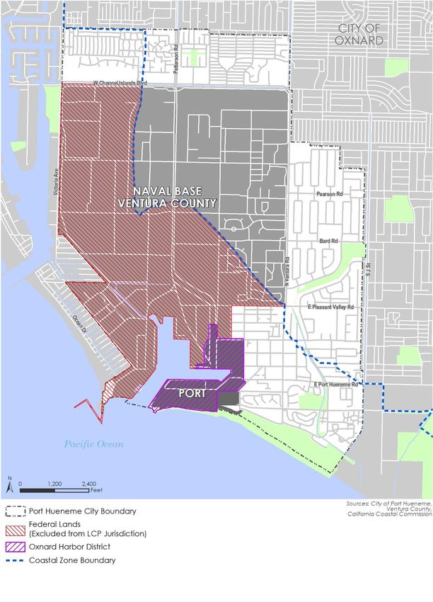
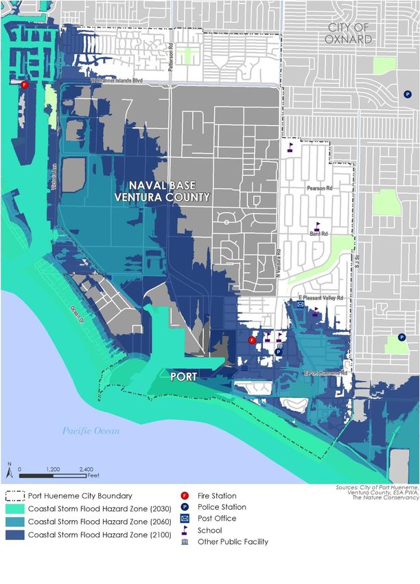
Table of Contents
Table of Contents
1 Local Coastal Program Introduction ...............................................................................................1
What is the Local Coastal Program? ...............................................................................................1
What Does This Have to do Port Hueneme? ..................................................................................1
How was the LCP Developed? ........................................................................................................3
What was the Process in Port Hueneme? ......................................................................................3
What is the Relationship Between the LCP, the General Plan, and Other Planning
Programs for the Coastal Area? ......................................................................................................3
What is the Relationship Between the LCP and the Oxnard Harbor District? Master Plan
for the Port of Hueneme? ...............................................................................................................4
2 Land Use Program ...........................................................................................................................5
Coastal Policies ...............................................................................................................................5
Existing Conditions and Potential Development ..........................................................................12
Local Coastal Land Use Plan..........................................................................................................25
Tables
Table 1 Potential Impacts of Sea Level Rise ....................................................................................24
Table 2 Coastal Zone Land Use Development Policy Matrix ...........................................................29
Figures
Figure 1 Coastal Zone .........................................................................................................................2
Figure 2 Coastal Zone Subareas and Key Development Sites ..........................................................11
Figure 3 Projected Coastal Erosion in Port Hueneme ......................................................................20
Figure 4 Projected Storm Flooding in Port Hueneme.......................................................................21
Figure 5 Projected Storm Wave Impact Port Hueneme ...................................................................22
Figure 6 Projected Rising Tide Impact in Port Hueneme ..................................................................23
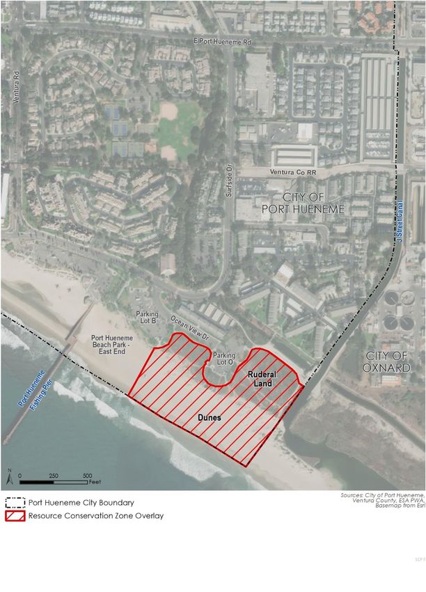
Figure 7 Resource Conservation Zone Overlay.................................................................................34
Figure 8 Land Use Designations........................................................................................................46
Figure 9 Zoning Districts ...................................................................................................................47
i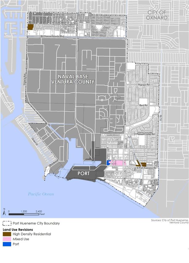
Local Coastal Program Amendment

                            This page intentionally left blank.

ii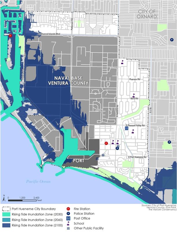
1           Local Coastal Program Introduction

What is the Local Coastal Program?
The Local Coastal Program (also called the LCP), mandated by the California Coastal Act of 1976, is a
planning document prepared by cities and counties who have shoreline areas. The California Coastal
Act is legislation intended to ensure that coastal areas of California are developed in a manner
responsive to public objectives. The Act establishes these objectives as Coastal policies, and
provides guidelines for municipal and county governments to reevaluate their existing coastal area
planning and zoning concepts to determine consistency with the Act.

The California Coastal Act of 1976 declares that:
     “to achieve maximum responsiveness to local conditions, accountability and public accessibility,
     it is necessary to rely heavily on local government and local land use planning procedures and
     enforcement”

in carrying out the state’s coastal objectives and policies. To this end, the Act directs each local
government lying wholly or partly within the coastal zone to prepare a Local Coastal Program (LCP)
for its portion of the coastal zone.

An LCP consists of:
     “a local government’s (a) land use plans, (b) zoning ordinances, (c) zoning district maps, and (d)
     within sensitive coastal resources, other implementing actions which, when taken together,
     meet the requirements of, and implement the provisions and policies of the Coastal Act at the
     local level.”

The land use plan, the heart of the LCP, is defined as:
     “the relevant portions of a local government’s general plan, or local coastal element, which are
     sufficiently detailed to indicate the kinds, location, and intensity of land uses, the applicable
     resource protection and development policies, and where necessary, a listing of implementing
     actions.”

What Does This Have to do Port Hueneme?
Much of the City of Port Hueneme is within the Coastal Zone, as shown in Figure 1. This document,
the Local Coastal Program, prescribes the policies and procedures governing use and development
of land within the Coastal Zone of Port Hueneme. For this Coastal area, the LCP becomes the
primary planning document, and takes precedence over prior planning and zoning.

The City of Port Hueneme received certification of their first Local Coastal Program on July 25, 1984.
The City’s LCP was comprehensively revised to reflect the new goals and policies contained in the
2015 General Plan Update.

                                                                                                          1
Local Coastal Program Amendment

Figure 1 Coastal Zone

2
Local Coastal Program Introduction

How was the LCP Developed?
Prior to certification of the City’s 1984 LCP, Port Hueneme could not unilaterally approve
development projects within the Coastal Zone. The Coastal Commission retains primary
responsibility and jurisdiction over the issuance of development permits for projects until the end of
the LCP certification process. Once the LCP has been certified, the ability to approve development
projects within the coastal zone reverts to the local agency, subject to the finding that the project is
consistent with the LCP. The City of Port Hueneme has been able to approve development projects
within its Jurisdiction since certification of the City’s LCP in 1984.

What was the Process in Port Hueneme?
The City of Port Hueneme completed a General Plan review and update in April 1977. The Plan
served as the foundation for the development of the City’s first Local Coastal Program. One of the
Plan’s major policies was the “creative utilization and preservation of the City’s natural assets, which
include the beach and harbor orientation”.
As a result, the General Plan recommendations were deemed to be fundamentally consistent with
the letter and more importantly with the spirit of the Coastal Act of 1976. After a series of public
meetings and hearings, Port Hueneme’s first LCP was certified by the California Coastal Commission
on July 25, 1984.
The Local Coastal Program was revised in conjunction with the City’s 2015 General Plan Update,
initiated in 1992 and certified in 1998. The revised General Plan considers coastal issues and
contains a number of goals and policies to conserve the City’s unique coastal resources. Similar to
the 1977 General Plan, the updated version contains a goal promoting “Creative utilization and
responsible conservation of the City’s major natural asset the beach and harbor environment.” The
revised Local Coastal Program reflects the City’s continued commitment to conserve coastal
resources.

What is the Relationship Between the LCP, the General
Plan, and Other Planning Programs for the Coastal Area?
Put simply, the Local Coastal Program constitutes a refinement of the land use policies and
implementing instruments of Port Hueneme’s General Plan (GP) as they pertain to development of
areas within the Coastal Zone. As the primary components of the General Plan, Port Hueneme’s
General Plan Update serves as the foundation upon which the LCP Land Use Plan is based.
Secondary components which serve to implement the LCP include:
▪   Ventura West Specific Area Plan
▪   Neighborhood Preservation Program
▪   Home Maintenance Incentive Rebate Program
▪   Neighborhood Strategy Area Urban Design Study

                                                                                                       3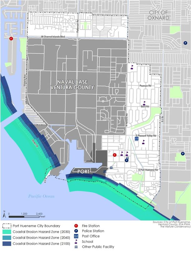
Local Coastal Program Amendment

What is the Relationship Between the LCP and the Oxnard
Harbor District? Master Plan for the Port of Hueneme?
The Coastal Act contains special provisions governing the ports of Port Hueneme, Long Beach and
Los Angeles, and the San Diego Unified Port District. These ports must prepare, adopt, and have
certified by the Coastal Commission a Port Master Plan. The Coastal Act provides that:
    “for information purposes, each city, county, or city and county which has a port within its
    jurisdiction shall incorporate the certified port master plan into its local coastal program.”

The Port Master Plan certified in May 1979, and as amended, by the Coastal Commission covers
only the area within the boundaries of the Port of Hueneme itself. This certified Master Plan was
incorporated by reference for information purposes into the City of Port Hueneme Local Coastal
Program in July 1984. The City of Port Hueneme and the Oxnard Harbor District have entered into
four additional agreements which affect future development in the Port. The Port Development
Review Committee Agreement created in April 1979, and amended in 1982, requires the
consultation and cooperation on planning for areas in and around the Port of Hueneme. In addition,
the City and District entered into an agreement in 1987, which requires the City to consider
amending the City’s General Plan, Local Coastal Program, and Zoning Ordinance to impose a single
zoning classification on property owned by the Oxnard Harbor District within the City. The
agreement further specifies that the City will institute development policies and standards which
streamline permit processing. In response to this agreement, the City has revised its General Plan to
have only a “Port” land use designation for property owned by the Oxnard Harbor District. In
addition, the Plan contains policies to streamline permit processing for District properties. Lastly,
the City and District entered into a Memorandum of Understanding in December of 1995 and
September of 2000, concerning acquisition and use of the former U.S. Naval Civil Engineering
Laboratory, which was closed and realigned in April 1996, under the third round of the U.S. Base
Realignment and Closure Act of 1990.
The Oxnard Harbor District adopted a Strategic Plan in 2020, which outlines goals and strategies to
guide the operations, business retention, growth, and future investments of the Port. Specific uses
as to land water and wharf areas within the confines of the harbor are governed by the Port
Strategic Plan authored and administered through the Oxnard Harbor District.

4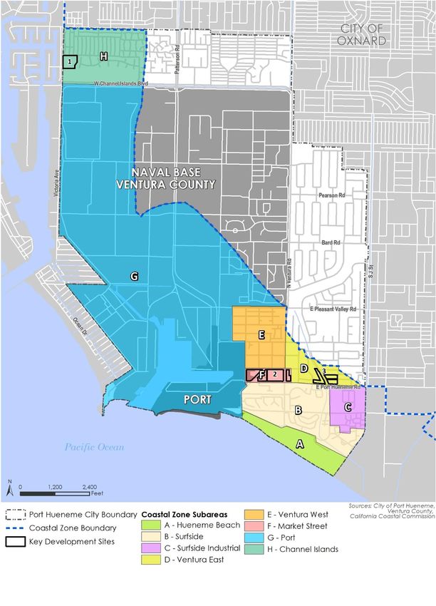
Land Use Program

    2           Land Use Program

The Local Coastal Program for the City of Port Hueneme must conform to the policies of the
California Coastal Act. These policies have been organized into 16 groups, as shown below:
▪       Shoreline Access
▪       Recreation and Visitor Serving Facilities
▪       Water Oriented Recreation
▪       Water and Marine Resources
▪       Diking, Dredging, and Filling
▪       Commercial Fishing and Recreational Boating
▪       Shoreline Structures/Flood Control
▪       Environmentally Sensitive Habitat Areas
▪       Agriculture
▪       Hazard Areas
▪       Soils Resources
▪       Archaeological/Paleontological Resources
▪       Locating and Planning New Development
▪       Coastal Visual Resources and Special Communities
▪       Public Works
▪       Industrial and Energy Development

The following sections briefly summarize applicable Coastal Act policies concerning these policy
groups. These descriptions are excerpted from the Local Coastal Program Manual published by the
California Coastal Commission and the California Coastal Act (Public Resources Code, Division 20).

Coastal Policies
Shoreline Access
Coastal Act Sections 30210 and 30211
Maximum access and recreational opportunities shall be provided for all the people, consistent with
public safety needs and the need to protect public rights, rights of private property owners and
natural resource areas from overuse. Development shall not interfere with the public’s right of
access to the sea.

Visitor Serving and Recreation Facilities
Coastal Act Sections 30212.5, 30213, and 30220
Wherever appropriate and feasible, public facilities, including parking, shall be distributed
throughout an area to mitigate against the impacts of overuse of any single area. Lower cost visitor

                                                                                                       5
Local Coastal Program Amendment and recreational facilities shall be protected, encouraged and where feasible, provided. De-velopments providing public recreational opportunities are preferred. Coastal areas suited for water oriented recreational activities that cannot readily be provided at inland water areas shall be protected for such uses. Water Oriented Recreation Coastal Act Section 30221 Oceanfront land suitable for recreational use shall be protected for recreational use and development, unless present and foreseeable future demand for public or commercial recreational activities that could be accommodated on the property is already adequately provided for in the area. Coastal Act Section 30222 The use of private lands suitable for visitor serving commercial recreational facilities designed to enhance public opportunities for coastal recreation shall have priority over private residential, general industrial, or general commercial development, but not over agriculture or coastal dependent industry. Water and Marine Resources Coastal Act Section 30230 Marine resources shall be maintained, enhanced, and where feasible, restored. Special protection shall be given to areas and species of special biological or economic significance. Uses of the marine environment shall be carried out in a manner that will sustain the biological productivity of coastal waters and that will maintain healthy populations of all species of marine organisms adequate for long term commercial, recreational, scientific, and educational purposes. Coastal Act Section 30231 The biological productivity and the quality of coastal waters, streams, wetlands, estuaries, and lakes appropriate to maintain optimum populations of marine organisms and for the protection of human health shall be maintained and, where feasible, restored through, among other means, minimizing adverse effects of waste water discharges and entrainment., controlling runoff, preventing depletion of ground water supplies and substantial interference with surface waterflow, encouraging waste water reclama-tion, maintaining natural vegetation buffer areas that protect riparian habitats, and minimizing alteration of natural streams. Coastal Act Section 30236 Channelizations, dams, or other substantial alterations of rivers and streams shall incorporate the best mitigation measures feasible, and be limited to: (1) necessary water supply projects, (2) flood control projects where no other method for protecting existing structures in the flood plain is feasible and where such protec-tion is necessary for public safety or to protect existing development, or (3) developments where the primary function is the improvement of fish and wildlife habitat. 6
Land Use Program

Diking, Dredging, Filling and Shoreline Structures
Coast Act Section 30233
(a) the diking, filling, or dredging of open coastal waters, wetlands, estuaries, and lakes shall be
per-mitted in accordance with other applicable provisions of this division, where there is no feasible
less environmentally damaging alter-native, and where feasible mitigation measures have been
provided to minimize adverse environmental effects. (b) Dredging and spoils disposal shall be
planned and carried out to avoid significant disruption to marine and wildlife habitats and

Commercial Fishing and Recreation Boating
Coastal Act Section 30224
Increased recreational boating use of coastal waters shall be encouraged, in accordance with this
division, by developing dry storage areas, increasing public launching facilities, providing additional
berthing space in existing harbors, limiting non-water dependent land uses that congest access
corridors and preclude boating support facilities, providing harbors of refuge, and by providing for
new boating facilities in natural harbors, new protected water areas, and in areas dredged from dry
land.

Coastal Act Section 30234
Facilities serving the commercial fishing and recreational boating industries shall be protected and,
where feasible, upgraded. Existing commercial fishing and recreational boating harbor space shall
not be reduced unless the demands for those facilities no longer exists or adequate substitute space
has been provided. Proposed recreational boating facilities shall, where feasible, be designed and
located in such a fashion as not to interfere with the needs of the commercial fishing industry.

Coastal Act Section 30255
Coastal dependent developments shall have priority over other developments on or near the
shoreline. Except as provided elsewhere in this division, coastal dependent developments shall not
be sited in a wetland.

Shoreline Structure
Coastal Act Section 30235
Revetments, breakwaters, groins, harbor channels, sea walls, cliff retaining walls, and other such
construction that alters natural shoreline processes shall be permitted when required to serve
coastal dependent uses or to protect existing structures or public beaches in danger from erosion
and when designed to eliminate or mitigate adverse impacts on local shoreline sand supply. Existing
marine structures caus-ing water stagnation contributing to pollution problems and fishkills should
be phased out or upgraded where feasible.

                                                                                                      7
Local Coastal Program Amendment Environmentally Sensitive Habitat Areas Coastal Act Section 30240 (a) Environmentally sensitive habitat areas shall be protected against any significant disruption of habitat values, and only uses dependent on such resources shall be allowed within such areas. (b) Development in areas adjacent to environmentally sensitive habitat areas and parks and recreation areas shall be sited and designed to prevent impacts which would significantly degrade such areas, and shall be compatible with the continuance of such habitat areas. Agriculture Coastal Act Section 30241 The maximum amount of prime agricultural land shall be maintained in production, and conflicts between agricultural and urban land uses shall be minimized. Stable boundaries shall be established separating urban and rural areas. Conversion of agricultural lands shall be limited to areas where the viability of existing agricultural use is already severely limited by conflicts with urban uses, and where the conversion would complete a logical and viable neighborhood and contribute to the establishment of a stable limit to urban development. Soil Resources Coastal Act Section 30243 The long term productivity of soils and timberlands shall be protected, and conversions of coastal commercial timberlands in units of commercial size to other uses or their division into units of noncommercial size shall be limited to providing for necessary timber processing and related facilities. Archaeological or Paleontological Resources Coastal Act Section 30244 Where development would adversely impact archaeological or paleontological resources as identified by the State Historic Preservation Officer, reasonable mitigation measures shall be required. Locating and Planning New Development Coastal Act Section 30250 (a) New development, except as otherwise provided in this division, shall be located within, contiguous with, or in close proximity to, existing development areas able to accommodate it, in other areas with adequate public services and where it will have significant adverse effects, either individually or cumulatively on coastal resources. In addition, land divisions, other than leases for agricultural uses, outside existing developed areas shall be permitted only where 50 percent of the usable parcels in the area have been developed and the created parcels would be no smaller than the average size of surrounding parcels. 8
Land Use Program

Coastal Act Section 30252
The location and amount of new development should maintain and enhance public access to the
coast by: (1) facilitating the provision of extension of transit service, (2) providing commercial
facilities within or adjoining residential development or in other areas that will minimize the use of
coastal access roads, (3) providing non-automobile circulation within the development, (4) providing
adequate parking facilities or providing substitute means of serving the development with public
transportation, (5) assuring the potential for public transit for high intensity uses such as high rise
office buildings, and by (6) assuring that the recreational needs of new residents will not overload
nearby coastal recreation areas by correlating the amount of development with local park
acquisition and development plans with the provision of onsite recreational facilities to serve the
new development.

Coastal Act Section 30253
New development shall: (1) Be consistent with requirements im-posed by an air pollution control
district or the State Air Resources Control Board as to each particular development, and (2)
Minimize energy consumption and vehicle miles traveled. Coastal Visual Resources and Special
Communities Coastal Act Section 30251: The scenic and visual qualities of coastal areas shall be
considered and protected as a resource of public importance. Permitted development shall be sited
and designed to protect views to and along the ocean and scenic areas, such as those designated in
the California Coastline Preservation and Recreation Plan prepared by the Department of Parks and
Recreation and by local government, and shall be subordinate to the character of its setting. New
development shall, where appropriate, protect special communities and neighborhoods which,
because of their unique characteristics, are popular visitor destination points for recreational uses.

Hazard Areas
Coastal Act Section 30253
New development shall: (1) minimize risks to life and property in areas of high geologic, flood, and
fire hazard; and, (2) Assure stability and structural integrity, and neither create nor contribute
significantly to erosion, geologic instability, or destruction of the site or surrounding area or in any
way require the construction of protective devices that would substantially alter natural landforms
alone bluffs and cliffs.

Public Works
Coastal Act Section 30254
New or expanded public works facilities shall be designed and limited to accommodate needs
generated by development or uses permitted consistent with the provisions of this division of the
Coastal Act. Where existing or planned public works facilities can accommodate only a limited
amount of new development, services to coastal dependent land use, essential public services and
basic industries vital to the economic health of the region, state or nation, public recreation,
commercial recreation and visitor serving land uses shall not be precluded by other development.

                                                                                                           9
Local Coastal Program Amendment
Industrial Development and Energy Facilities
Coastal Act Sections 30255 and 30260
Coastal dependent developments shall have priority over other developments on or near the
shoreline. Coastal dependent industrial facilities shall be encouraged to locate or expand within
existing sites and shall be permitted reasonable long term growth where consistent with this
division of the Coastal Act.
The Coastal Act defines “coastal dependent development or use” as:
“any development or use which requires a site on, or adjacent to, the sea to be able to function
at all.”
Given this definition of “coastal dependent,” “coastal dependent industry” is therefore industrial
development which requires water adjacency.
Housing
Housing policies for coastal areas are now included in the California Government Code Article 10.7,
Section 65590. As a result, this Local Coastal Program does not discuss coastal housing issues.
The following section analyzes existing conditions and potential development in the City’s Coastal
Zone. To facilitate this analysis, the City’s Coastal Zone was divided into 11 subareas, which are
shown in Figure 2.
The City of Port Hueneme is approaching buildout with very few sites available for new
development. The 2045 General Plan Update concentrates on three key development sites that are
vacant, underutilized or may convert to other uses. With regard to the Local Coastal Program, all
three of these key development sites are located within the Coastal Zone. The following sections
identify the future development sites and define specific development policies for each coastal
subarea.
10Land Use Program
Figure 2 Coastal Zone Subareas and Key Development Sites
11Local Coastal Program Amendment
Existing Conditions and Potential Development
Area A: Hueneme Beach Park – 68 Acres
Existing Land Use
▪ Recreation
General Plan Land Use
▪ Parks and Open Space
Area A is entirely in public (City of Port Hueneme) ownership. There is no development except for
beach-related structures (pier, concession stand/restaurant, restrooms) and public parking lots. The
beach is a recreational resource of regional importance, attracting visitors from all parts of Ventura
County as well as from neighboring Los Angeles.
A comprehensive plan for park improvements has been prepared, which includes projected
improvements to the Hueneme Beach Park over a five- to ten-year period. Planned improvements
to existing restrooms, picnic areas, play areas, and volleyball courts are inadequate. In conjunction
with these improvements, an inclusive playground, a dog park, and new restaurant and rentals
options were identified. The connection between the Bubbling Springs Recreational Corridor and
Hueneme Beach Park was also identified as a key opportunity. Key to these improvements to beach
facilities is maintaining the sand replenishment program to prevent beach erosion caused by the
jetty at the mouth of the Port.1
Area B: Surfside – 90 acres
Existing Land Use
▪ Vacant
▪ Low Density Residential
▪ Medium Density Residential
▪ High Density Residential
▪ Park
▪ Commercial
General Plan Land Use
▪ Low Density Residential
▪ Medium Density Residential
▪ High Density Residential
▪ Commercial
▪ Parks and Open Space
Surfside is the beachfront residential area. Major existing residential development in the area
consists of recently built high and medium density condominiums (approximately 12-25 dwelling
1
This program is conducted by the Army Corps of Engineers.
12Land Use Program
units per acre) and a City owned 30 unit below market rent garden apartment complex (Seaview
Apartments).
The majority of commercial development in Area B is located along Hueneme Road. Commercial
development consists primarily of neighborhood shopping areas and a hotel. The area also contains
the headquarters of the local VFW Chapter, Moranda Park, a community recreation facility, and a
portion of the Bubbling Springs Recreational Corridor.
Improvements to Moranda Park have greatly enhanced access to and from adjacent public and
private developments. In addition, integration of Moranda Park with the surrounding area has been
vastly improved by the realignment of the entrance from Port Hueneme Road and landscape/open
space treatment integration of the park with the surrounding of the southwest comer of Surfside
Drive and Port Hueneme Road. Additional planned park improvements for Moranda Park includes
tennis and park facilities, multipurpose fields, an enhanced walk path with rails to trails connection
along the southern boundary of the park, and consolidating play areas.
The Bubbling Springs Recreational Corridor was formerly a drainage channel. Improvements have
been undertaken to convert it into a recreational corridor, linking Richard Bard Bubbling Springs
Park (outside the Coastal Zone) with Moranda Park and Hueneme Beach Park. Improvements to
Bubbling Springs Recreational Corridor were approved by the South Coast Regional Commission
under Development Permit 137-02.
Area C: Surfside Industrial – 40 Acres
Existing Land Use
▪ Vacant
▪ Industrial
▪ Public Facilities
General Plan Land Use
▪ Public Facilities
▪ Industrial
Area C contains industrial uses (general industrial, mini storage) and public facilities. General Plan
land use and zoning designate the area for light industrial and public facilities use.
Area D: Ventura East – 30 Acres
Existing Land Use
▪ Vacant
▪ Low Density Residential
▪ Medium Density Residential
▪ Commercial
▪ Public Facilities
▪ Park
13Local Coastal Program Amendment General Plan Land Use ▪ Commercial ▪ Public Facilities ▪ Parks, and Open Space ▪ Low Density Residential ▪ Medium Density Residential ▪ High Density Residential Area D consists primarily of residential uses of various housing types and densities. Ventura East also contains the Port Hueneme Civic Center and a small number of commercial uses along Port Hueneme and Ventura Roads. The Bubbling Springs Recreational Corridor passes through Area D. The portion of Ventura East that faces Port Hueneme Road also contains a number of commercial establishments that may be considered “recreation and visitor serving facilities”. Existing commercial establishments include two motels and several small retail businesses, which primarily consists of local restaurants, hair salons, and liquor stores. These commercial retail establishments primarily serve local residents and business related (Navy) visitors. However, the proximity of this area to Hueneme Beach Park suggests that these establishments do cater to beach visitors, especially in summer. Medium Density Residential uses are planned to accommodate up to an estimated 133 dwelling units. Additional parcels are planned for High Density Residential use and future commercial development. Currently, these sites contain a variety uses, including vacant lands, residential development, and commercial development. Area E: Ventura West – 77 Acres Existing Land Use ▪ Commercial ▪ Public Facilities ▪ Vacant Land ▪ Low Density Residential ▪ Medium Density Residential ▪ High Density Residential General Plan Land Use ▪ Commercial ▪ Public Facilities ▪ Low Density Residential ▪ Medium Density Residential ▪ High Density Residential ▪ Mixed Use 14
Land Use Program

Ventura West is primarily a residential area, with a mix of single family (5,000 square foot lot
average) and multifamily units. Commercial development (motel, body shop, cannabis dispensary,
restaurants, junior market) is concentrated along Pleasant Valley Road at the north end of the area.
Also located within Area E are an elementary school, fire station, residential care facility, hospital,
pharmacy and medical offices. Area E also contains Mar Vista, a 60 unit assisted housing senior
citizens residence. Another 90 unit senior citizens residence, Casa Pacifica, is also located within
Ventura West. Ventura West has been classified as a “deteriorated” neighborhood for which a
Specific Area Plan has been prepared and adopted governing the scope of revitalization proposed
therein. With the overall objective being the maintenance of this neighborhood as a source of low
and moderate income housing, specific actions proposed as part of the Ventura West Specific Area
Plan include:
▪   Housing rehabilitation, code enforcement and selective site clearance and acquisition to
    effectuate neighborhood revitalization.
▪   Downzoning commensurate with the pre-dominance of single family residences, proximity to
    major thorough fares and dwelling units suitable for rehabilitation.
▪   Realignment of interior streets to reinforce “a sense of place” and neighborhood character.

By virtue of the dilapidated conditions prevalent within the “ABC” Street portion of Ventura West
(four block area located westerly of Ponoma Street between Pleasant Valley Road and Clara Street)
together with its proximity to the NBVC and Port of Hueneme, the City has maintained a transitional
zoning classification which provides for the simultaneous development of residential and harbor
related uses for this area. As one of several tasks included within the scope of the joint Oxnard
Harbor District/City Coastal Energy Impact Program Study, the “ABC” area was examined in detail
relative to the potential of redeveloping the same for immediate industrial reuse. For a variety of
reasons, it was concluded that such an endeavor, at least for the near term, would not be
economically feasible; hence, its preclusion from the LCP and General Land Use Plan.
The Ventura West Area is planned to maintain existing residential and commercial development and
accommodate new mixed use development. Remaining development sites in the area contain
various land uses, including a motel and various commercial uses. The land use plan continues to
support future commercial development. Medium density residential development is planned to
accommodate an additional 21 dwelling units. Additional areas will continue to accommodate
residential uses with an additional 16 dwelling units slated for these sites.

Area F: Market Street – 8 Acres
Existing Land Use
▪   Vacant
▪   Commercial
▪   Park
▪   Public facility

General Plan Land Use
▪   Parks and Open Space
▪   Mixed Use

                                                                                                     15
Local Coastal Program Amendment ▪ Public Facilities ▪ Port Market Street is the remaining commercial nucleus of Port Hueneme's former downtown and is envisioned to become a gathering place with a mix of shops and housing in a pedestrian oriented environment. Almost the entire Market Street area is in key development site 2. The area is zoned for a mix of port related uses and mixed use, and contains a variety of small retail shops, the Hueneme Bank building (an historic landmark and home of Port Hueneme Museum), and a few vacant parcels. The General Plan update supports the development of a mix of visitor serving commercial and residential along with harbor related office and warehouse uses in areas proximate to the Port of Hueneme, Market Street included. Area G: Port of Hueneme/Oxnard Harbor District and Naval Base Ventura County (NBVC) – 939.1 acres Existing Land Use ▪ Harbor Related ▪ Vacant General Plan Land Use ▪ Port ▪ Parks and Open Space ▪ Visitor Commercial Port The NBVC controls the remainder of the harbor area. Federal facilities such as the NBVC are exempt from the LCP except that the City may provide for interim zoning for federal lands which is applicable immediately upon divestiture. The Port of Hueneme is an important commercial and industrial area within the city and is under the jurisdiction of the Oxnard Harbor District. These properties are used for ship offloading facilities, warehouses, port related public open space, and recreational uses, and fuel storage facilities. Port activity is buffered from nearby residential areas and access is controlled to minimize impacts on city streets. The Oxnard Harbor District adopted a Strategic Plan in 2020, which outlines goals and strategies to guide the operations, business retention, growth, and future investments of the Port. Specific uses as to land water and wharf areas within the confines of the harbor are governed by the Port Strategic Plan authored and administered through the Oxnard Harbor District. Area H: Channel Islands – 160 Acres Existing Land Use ▪ Vacant ▪ Commercial ▪ Low Density Residential ▪ Medium Density Residential ▪ High Density Residential 16
Land Use Program
General Plan Land Use
▪ Commercial
▪ Low Density Residential
▪ Medium Density Residential
▪ High Density Residential
Area K has developed primarily with residential units. Both single family and multifamily units are
located in Area K. Commercial development (office, neighborhood commercial, specialty retail) is
located along Channel Islands Boulevard.
Key development site 1 is located in the Channel Islands area. The site encompasses approximately
4.5 acres and is currently vacant. The site is planned for General Plan Land Use High Density
Residential. The General Plan calls for the continued development of commercial uses along
Channel Islands Boulevard and the preservation of low, medium, and high density dwelling units.
Areawide Hazardous Wastes
The City of Port Hueneme has problems and opportunities involving the generation, local storage,
transfer and disposal of hazardous wastes and materials as does any urban area. There are also
special sources of hazardous wastes and materials associated with the NBVC Center, Port of
Hueneme, railroad, and oil storage and transportation. A County and City Hazardous Waste Plan,
under guidance of the State Department of Health Services, has been prepared as authorized by
passage of Assembly Bill 2948 (Tanner 1986). The Plan serves as the primary planning document to:
▪ Analyze hazardous waste generation
▪ Determine facility capacities and needs
▪ Reduce waste generation and hazard
▪ Manage small hazardous waste volumes
▪ Determine the need for additional facilities
▪ Identify locations for expansion and new facilities
▪ Set goals, objectives, and policies through the year 2000
▪ Schedule City and County implementation
As provided under the State Health and Safety Code (Section 25135.7), the City of Port Hueneme
has chosen to incorporate by reference the County Plan into the City’s Zoning Ordinance. The
County Plan intends to develop further provisions to specifically allow hazardous waste and
materials handling facilities in certain zones within the coastal zone as necessary in the future. Any
subsequent changes in the County Plan will require an amendment to the Land Use Plan of this
Local Coastal Program. The City will participate in hazardous waste control through participation in
intergovern-mental efforts such as joint powers agreements.
Sea Level Rise
Sea levels in California are expected to rise in the coming decades as a result of global greenhouse
gas emissions. It is anticipated that until midcentury, the most damaging events for the California
coast will be dominated by large El Niño driven storm events in combination with high tides and
large waves. By the end of the century, as sea levels continue to rise, scientists project that even
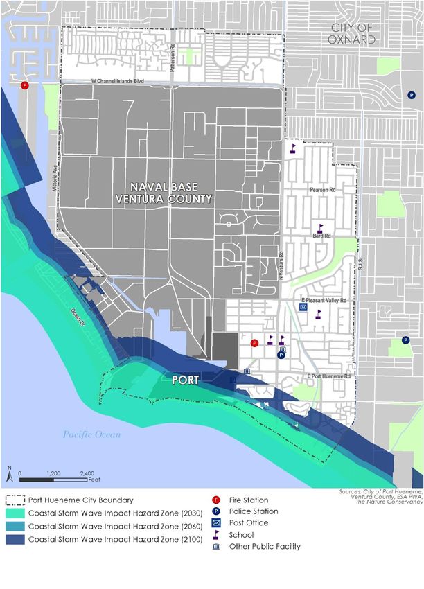
17Local Coastal Program Amendment small storms may cause substantial damage and large events will have unprecedented consequences (CCC 2018). The physical effects of sea level rise include temporary flooding and daily inundation, wave impact, erosion, and saltwater intrusion impacting groundwater. Coastal Erosion Port Hueneme’s coast is susceptible to coastal erosion. As sea levels rise, the amount of time that Port Hueneme’s beaches are exposed to waves and abnormally high tides increases, furthering beach erosion. Figure 3 shows projected coastal erosion in Port Hueneme for 2030, 2060, and 2100 based on the Coastal Resilience Ventura tool’s high projections for sea level rise (TNC n.d.a).2,3 The 2030 projections show erosion impacts to the sand at Port Hueneme Beach Park. According to the projections, the rate of erosion could result in no beach by 2060 and by 2100 coastal erosion is expected to impact East and South Surfside Drive, Shoreview Drive, Market Street, and residential development surrounding these streets. Storm Flooding Climate change may cause low lying coastal areas such as Port Hueneme to experience more frequent flooding and an increase in the inland extent of 100 year coastal floods. Drainage systems that discharge close to sea level may also have similar issues and inland areas may become flooded if outfall pipes back up with saltwater (CCC n.d.) Figure 4 shows projected storm flooding in Port Hueneme for 2030, 2060, and 2100 (TNC n.d.a). The 2030 projections mainly show impacts to Port Hueneme Beach Park and East Surfside Drive. The 2060 and 2100 projections show substantially more flooding reaching as far as East Pleasant Valley Road from the south and the intersection of Crossjack Street and Sextant Avenue from the west. This level of flooding could affect roads, high medium and low density residential developments, fire stations, the police department, and commercial and industrial areas in the City. Storm Wave Impact Rising sea levels will cause waves to force water further inland, especially during coastal storm events (CCC n.d.). If waves become larger and more frequent, they are expected to increase erosion of Port Hueneme’s beaches, possibly damaging development. Figure 5 shows the projected storm wave impact in 2030, 2060, and 2100 in Port Hueneme (TNC n.d.a). In 2030, storm wave impacts are expected to reach Hueneme Beach Park and small portions of East Surfside Drive. By 2060 and 2100, the impacts are expected to reach just below Port Hueneme Road, South Ventura Road, and South Surfside Drive. These impacts could affect circulation, medium and high-density residential areas, and parks and open space. Rising Tide Sea level rise will cause areas not currently exposed to the tide to be inundated (CCC n.d.) Unlike flooding, inundation involves the presence of permanent standing water, often resulting in the need to either protect or move infrastructure and development. Figure 6 shows projected rising tide impacts in 2030, 2060, and 2100 in Port Hueneme (TNC n.d.a). Near term impacts (i.e., 2030 and 2060) from projected rising tides in Port Hueneme are minimal. By 2100, projections indicate that 2 Where beaches are controlled in part by dredge placements, such as those in Port Hueneme, the projections assume there is no change in existing dredging practices (ESA PWA 2013). Beyond current dredging practices, the model does not account for other shore management actions to prevent erosion (ESA PWA 2013). 3 Coastal Resilience Ventura was developed in 2013 by The Nature Conservancy and Ventura County. 18
Land Use Program

rising tides could impact Hueneme Beach Park and commercial and residential areas north of West
Channel Islands Boulevard, south of West Hemlock Street and West of Yardarm Avenue.

Sea Level Rise Hazard Zones
Managing development to respond to coastal hazards is a key component of a local coastal
program. Coastal Act policies direct new development to reduce risks to life and property and avoid
substantial changes to natural landforms. Due to its location on the coast, Port Hueneme faces a
substantial risk of increased flooding, beach loss, erosion, and storm damage as a result of sea level
rise. Increasing temperatures, changes in precipitation patterns, and increasing intensity of coastal
storms are all climate change related challenges that will affect the City in the coming decades.
Community members particularly vulnerable to hazards related to sea level rise are identified in
Table 1. The vulnerability of built and natural assets are also described below.

                                                                                                    19
Local Coastal Program Amendment Figure 3 Projected Coastal Erosion in Port Hueneme 20
Land Use Program

Figure 4 Projected Storm Flooding in Port Hueneme

                                                                  21
Local Coastal Program Amendment Figure 5 Projected Storm Wave Impact Port Hueneme 22
Land Use Program

Figure 6 Projected Rising Tide Impact in Port Hueneme

                                                                      23
Local Coastal Program Amendment
Table 1 Potential Impacts of Sea Level Rise
Sensitivity Impact
Type Sensitivity Impact Description Score
Unemployed Impacts of sea level rise are likely to result in minimal impacts to Low
Individuals unemployed individuals, those with educational attainment less than
a bachelor’s degree, and uninsured individuals.
Individuals with
Educational
Attainment Less
Than Bachelor’s
Degree
Uninsured
Individuals
Renters Rental units are present along the coast in Port Hueneme. Renters Medium
have less control over home improvements than homeowners and
may not be able to adequately protect themselves by retrofitting
their units or preparing for flooding. Additionally, they cannot control
the timing of repairs.
Individuals with Individuals with impaired health may have difficulties evacuating in High
Impaired Health the event of a coastal flooding event. Additionally, indirect impacts
such as respiratory issues caused by mold in flood damaged homes,
illness from contaminated drinking water, and mental health issues
caused by displacement may substantially impact individuals with
impaired health (CDPH 2020).
Young Children Direct impacts of sea level rise are likely to result in minimal impacts High
to young children. However, indirect impacts such as respiratory
issues caused by mold in flood damaged homes, illness from
contaminated drinking water, and mental health issues caused by
displacement may impact young children substantially (CDPH 2020).
Non-English Non-English speakers may not have access to adequate safety High
Speakers information, such as evacuation or recovery information, in their
native language.
Outdoor Workers Impacts of sea level rise are likely to result in minimal impacts to Low
outdoor workers because they would be able to leave before
flooding.
Isolated Individuals Isolated individuals (those with low transit access and no access to a High
car) may have difficulties preparing and evacuating during flooding
events and receiving access to care (CDPH 2020).
Municipal Buildings The post office is located south of East Pleasant Valley Road, where Medium
storm flooding is projected to occur by 2100 (shown in Figure 5
above).
Medical Facilities Two medical facilities are located south of East Pleasant Valley Road, Medium
where storm flooding is projected to occur by 2100 (shown in
Figure 5 above).
Educational and Three schools are located south of East Pleasant Valley Road, where Medium
Childcare Facilities storm flooding is projected to occur by 2100 (shown in Figure 5
above).
Public Safety Emergency response systems could be affected by flooding through Medium
Infrastructure and restricted access to and from emergency response facilities, such as
Response the fire station, increasing response times for emergency services.
The fire station and police department are located south of East
Pleasant Valley Road, where storm flooding is projected to occur by
2100 (shown in Figure 5 above).
24Land Use Program
Sensitivity Impact
Type Sensitivity Impact Description Score
Port Hueneme Pier Although the pier’s hourglass shape makes it more resistant to winter Medium
storms than it was previously, its location makes it susceptible to
future sea level rise impacts such as storm flooding, storm wave
impact, and rising tides.
Residential and Residential and commercial development located south of East High
Commercial Pleasant Valley Road are particularly vulnerable to storm flooding
Development projected to occur by 2100.
Roadways and Coastal erosion and flooding may impact the City’s roads, especially High
Transportation South Ventura Road and portions of West Channel Islands Boulevard,
Facilities inhibiting people from moving through affected areas of the city
during and following storms/floods.
Parks and Open Port Hueneme Beach Park is vulnerable to sea level rise as it is High
Space located in the 2030 coastal erosion, storm flooding, and storm wave
impact zones. Other parks are located farther from the coast and
therefore are not as immediately vulnerable.
Natural Habitat Sea level rise threatens coastal habitats and damage to these habitats High
reduces a community’s resilience against flooding and erosion (CDPH
2020).
Water and Sewer infrastructure, such as the two pumping stations located south Medium
Wastewater of East Port Hueneme Road, could be impacted by projected storm
Services flooding by 2060.
Energy Delivery Energy infrastructure throughout the City, including electricity and Medium
natural gas above and below ground utility lines, may be vulnerable
to sea level rise impacts through direct inundation or storm surge.
Additional information on the vulnerability of Port Hueneme to sea level rise is provided in the
Climate Change Vulnerability Assessment (February 2021) which is included as an appendix to this
LCP.
Local Coastal Land Use Plan
The planning process for the updated General Plan devoted a great deal of attention to
development of consensus among citizens, staff, and the consultant team on a set of goals and
objectives to guide the future development of the City. Because the General Plan was and is seen as
the “blueprint” planning document for development of Port Hueneme, the establishment of
obtainable goals specifically related to conditions in Port Hueneme, rather than generalized goals
which might be considered objectives for any city, was considered essential. These goals as stated in
the General Plan remain valid, and are the basis upon which the City’s Local Coastal Program has
been developed.
Land Use
LU 1 Continued development of land uses that will create and sustain a strong, viable economic
base for the City.
LU 2 Creative utilization and responsible conservation of the City’s major natural asset the
beach and harbor environment.
LU 3 Development and maintenance of a housing stock that meets the needs of local residents.
25Local Coastal Program Amendment
LU 4 “Fair share” payment for use of City services and facilities.
LU 5 Protection of the City’s interests by continuing collaboration efforts with adjacent and
regional jurisdictions to address common issues, including air quality, transportation, water
quality and supply, solid disposal, and natural hazards (e.g., sea level rise).
LU 6 An aesthetically pleasing and efficiently organized city.
Circulation
CI 1 Provision of a comprehensive transportation system for the movement of persons and
goods with maximum safety, efficiency, equity, and convenience.
CI 2 Provision of a balanced roadway system that will provide adequate accessibility to existing
and future land uses with minimum impact on residential neighborhoods.
CI 3 Encouragement of alternative transportation modes to reduce the use of single passenger
vehicles.
CI 4 Improvement of accessibility and integration of the City with the regional transportation
system.
Conservation and Open Space
COS 1 Protection of the remaining native and non-native plant and animal species in the city.
COS 2 Preservation of remaining open space areas and maintain recreational facilities.
COS 3 Development, financing, and maintenance of local parks, recreation, and community
service facilities that meet the needs of the residents of Port Hueneme.
COS 4 Operation of recreation and community service programs that meet the needs of all
sections of the City’s population.
COS 5 Preservation of existing water resources.
COS 6 Conservation of energy resources through the use of available technology and
conservation practices.
COS 7 Minimization of solid waste produced in Port Hueneme.
COS 8 Maintenance and enhancement of the City’s historic and cultural resources.
Air Quality
AQ 1 Reduction of air pollution generated by passenger vehicles.
AQ 2 Minimization of exposure to air pollutants, including toxic air contaminants.
Climate Action Plan
CAP 1 Reduced greenhouse gas emissions from energy use in buildings.
CAP 2 Reduced greenhouse gas emissions from transportation.
CAP 3 Reduced greenhouse gas emissions from solid waste.
CAP 4 Reduced greenhouse gas emissions from water use.
CAP 5 Increased sequestration from City’s urban forest.
CAP 6 Integration of climate change planning best practices into government processes and
structures to foster increased communitywide resilience.
CAP 7 Protection of residents, businesses, and infrastructure from climate change impacts.
26Land Use Program
Housing Element
HE 1 Maintenance and enhancement of the quality of residential neighborhoods in Port
Hueneme.
HE 2 Adequate provision of housing by location, type of unit, and price to meet the existing and
future needs of Port Hueneme
HE 3 Provision of increased opportunities for home ownership.
HE 4 Removal of governmental constraints on housing development.
HE 5 Promotion of fair housing practices.
Noise
N1 Protection of the Public from excessive noise and vibration from both stationary and
mobile noise sources.
Public Safety and Facilities
PSF 1 Protection of Port Hueneme’s residents, workers, and visitors from natural hazards,
including flood and seismic.
PSF 2 Minimization of impacts to life and property associated with the use, storage, or transport
of hazardous material and urban fire hazards.
PSF 3 Protection of all persons and property from criminal activities.
PSF 4 Provision of opportunities for quality education to all kindergarten, elementary school,
middle school, and high school aged residents.
PSF 5 Maintain a consistent level of quality water service in the city.
PSF 6 Maintenance of a consistent level of quality sewer service throughout the entire city.
PSF 7 Provision and maintenance of necessary storm drainage control facilities.
PSF 8 Provision of adequate utility infrastructure by service providers in an aesthetically pleasing
way; promotion of energy conservation through application of energy saving technology
and available energy.
PSF 9 Provide quality communication systems that meet the demands of new and existing
development in the city.
PSF 10 Protection of public’s safety at public parks and recreation facilities.
PSF 11 Protection of Port Hueneme’s public safety from infectious diseases.
Social Equity
SE 1 Minimization of exposure to pollution, including the improvement of air quality.
SE 2 Promotion of public facilities, food access, affordable housing, and physical activity.
SE 3 Equitable civil engagement in the public decision making process.
SE 4 Prioritize improvements and programs that address the needs of disadvantaged
communities.
27Local Coastal Program Amendment
To these fundamental General Plan goals, the Local Coastal Program adds the following objectives
as shown below:
LCP-1 To maximize public opportunities for coastal access and recreation in a manner which
protects natural resource areas from overuse, maintains public safety needs and respects
the rights of private property owners.
LCP-2 To protect, encourage and, where feasible, provide for increased recreational opportunities,
including low and moderate cost facilities, within and adjacent to beach and harbor areas
through both public and private development.
LCP-3 To accommodate expansion of the Port of Hueneme in a manner which is compatible with
the policies and land use designations of the LCP.
This is the most important section of the Local Coastal Program, because it establishes policies
consistent with the Coastal Act to serve as guidelines for future development of the City’s Coastal
Zone. Table 2 shows the relationship of City General Plan goals and Citywide LCP objectives
(presented above) to each geographic sub area in the Coastal Zone. Table 2 also indicates the
Coastal Act policy groups of concern to the geographic sub areas within Port Hueneme.
The following sections define specific development policies for each Coastal subarea, as well as land
uses consistent with such policies.
28I.
F.
E.
C.
B.
A.
D.
H.
G.
Surfside
Areawide
and NBVC1
Ventura East
Ventura West
Market Street
Channel Islands
Hueneme Beach
Port of Hueneme
Surfside Industrial
Local Coastal Program Objectives
LCP-3
LCP-3
LCP-2
LCP-1
LCP-3
LCP-2
LCP-1
LCP-1
LCP-3
LCP-2
LCP-1
LCP-2
LCP-1
✓
✓
✓
✓
Shoreline Access
Visitor Serving and Recreation
✓
✓
✓
✓
✓
Facilities
✓
✓
Water Oriented Recreation
✓
✓
✓
Water and Marine Resources
Table 2 Coastal Zone Land Use Development Policy Matrix
Commercial Fishing and
✓
✓
✓
Recreational Boating
Shoreline Structure and Flood
✓
Control
Environmentally Sensitive
✓
✓
Habitat Areas
Locating and Planning New
✓
✓
✓
Development
Coastal Visual Resources and
✓
✓
✓
✓
✓
Special Communities
✓
Hazard Areas
Industrial and Energy
✓
✓
Development
✓
✓
Coastal Dependent Industry
✓
Public Works
✓
Agriculture
Land Use Program
29You can also read