ORDINARY COUNCIL MEETING 25 SEPTEMBER 2018 - Port Stephens Council
←
→
Page content transcription
If your browser does not render page correctly, please read the page content below
ORDINARY COUNCIL – 25 SEPTEMBER 2018 – TABLED DOCUMENT

                  TABLED DOCUMENT

                         ITEM NO. 4.2
    NELSON BAY TOWN CENTRE AND FORESHORE STRATEGY
         IMPLEMENTATION AND DELIVERY PROGRAM

  NELSON BAY TOWN CENTRE DELIVERY
              PROGRAM

        ORDINARY COUNCIL MEETING
            25 SEPTEMBER 2018

PORT STEPHENS COUNCIL                                    1
Progressing the Nelson Bay Town
  Centre & Foreshore Strategy:
  A revised implementation and delivery program

                                  council@portstephens.nsw.gov.au | 02 4988 0255
                                  PORTSTEPHENS.NSW.GOV.AU
Abbreviations
ASF                Active Street Frontages

CP                 Contributions Plan

DA                 Development Application

Delivery Program   Progressing the Nelson Bay Town Centre and Foreshore Strategy –
                   A Revised Implementation and Delivery Program

DCP                Port Stephens Development Control Plan 2014

FSR                Floor Space Ratio

HFSS               Heritage Floor Space Scheme

HoB                Height of Building

HVRF               Hunter Valley Research Foundation

LEP                Port Stephens Local Environmental Plan 2013

LGA                Local Government Area

LHUDA              Lower Hunter Urban Design Awards

PIA                Planning Institute of Australia

Paper              Progressing the Nelson Bay Town Centre and Foreshore Strategy – A
                   Discussion Paper

PSC                Port Stephens Council

PSPS               Port Stephens Planning Strategy

RFB                Residential Flat Building

RT&H               Raymond Terrace and Heatherbrae Strategy

SAMP               Strategic Asset Management Plan

SEPP               State Environmental Planning Policy

SMART              Specific, Measurable, Achievable, Realistic and Time-Based

Strategy           Nelson Bay Town Centre and Foreshore Strategy

Survey             Survey of Stakeholders in the Nelson Bay Strategy for Port Stephens Council

UFM                Urban Feasibility Model

VPA                Voluntary Planning Agreement

                                                                                                 2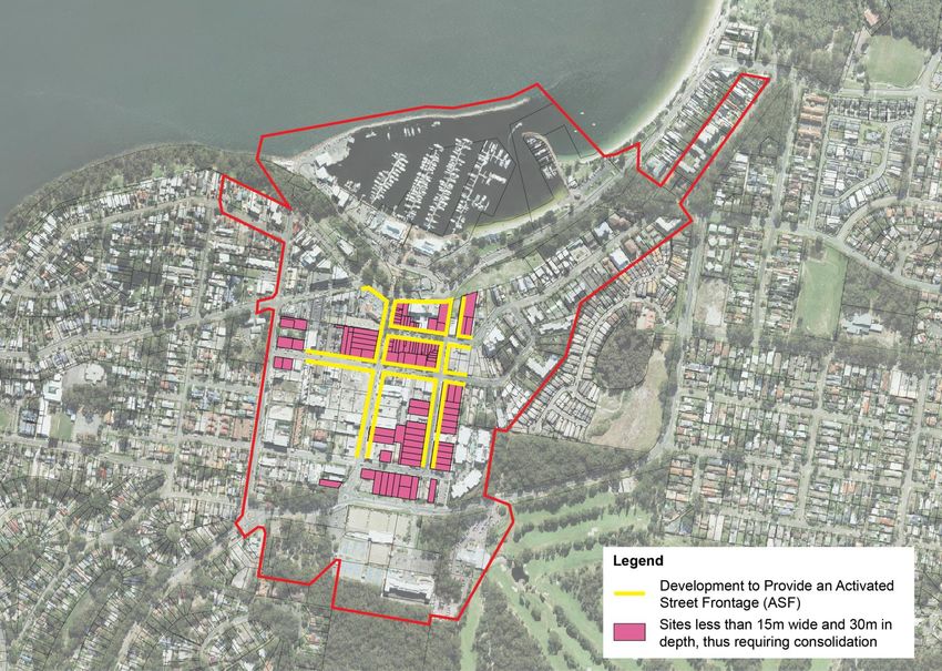
List of Figures
Figure 1    Summary of Implementation Plan

Figure 2    Strategy Hierarchy

Figure 3    Illustration of Design Excellence

Figure 4    Illustration of the Nelson Bay Woolworths

Figure 5    Identification of Activated Street Frontages and Lots less than 15m by 30m

Figure 6    Extension of the Strategy Boundary

Figure 7    Development Consents and Unacted Approvals (1996-2006)

Figure 8    Five Sites Identified for Feasibility Testing

Figure 9    Table summarising what conditions provide for a viable profit margin

Figure 10   Line graph illustrating the varying profit margins

Figure 11   Line graph illustrating similar property markets

Figure 12   Proposed HoB and FSR

Figure 13   Illustration of proposed HoB and FSR

Figure 14   Apex Park Masterplan

Figure 15   Public Parking Locations

Figure 16   Average Public Parking Utilisation Rates for the Town Centre

Figure 17   Average Public Parking Utilisation Rates for the Foreshore

Figure 18   Endorsed Yacaaba Street Extension Option

Figure 19   Identified Projects and relevant costings

Figure 20   Monitoring, Reporting and Review Cycle

                                                                                         3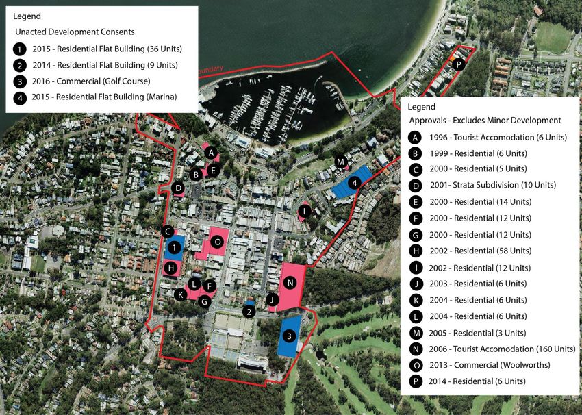
Table of Contents
Abbreviations                                                                            2

List of Figures                                                                          3

Table of Contents                                                                        4

Executive Summary                                                                        6

Part One - The Review                                                                    8

        The Need for a Review                                                            8

        Hunter Regional Plan 2036                                                        8

        Discussion Paper – Progress of the Nelson Bay Town Centre & Foreshore Strategy   9

Part Two – The Way Forward                                                               10

        Improving the Strategy                                                           10

        2.1       Design Excellence                                                      14

        2.2       Building Heights                                                       20

        2.3       Development Incentives                                                 30

        2.4       Public Domain                                                          32

        2.5       Transport and Parking                                                  36

        2.6       Implementation and Delivery                                            42

References                                                                               47

Attachment 1 – Implementation Plan                                                       48

                                                                                              4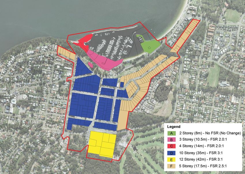
Executive Summary
'Progressing the Nelson Bay Town Centre and Foreshore Strategy – A Revised Implementation and
Delivery Program' (the Delivery Program) follows on from the public exhibition of the 'Discussion Paper –
Progress of the Nelson Bay Town Centre and Foreshore Strategy' (the Paper) which sought to review the
Nelson Bay Town Centre and Foreshore Strategy 2012 (the Strategy).

This work has primarily sought to understand why limited private investment and economic development
had occurred in Nelson Bay town centre, despite the past decade being one of significant growth for the
housing industry, and how the town centre can be revitalised.

Community consultation was undertaken on both the Paper and a draft Delivery Program in 2017 and
2018. The community has been highly engaged in the process of developing this Delivery Program,
including participating in online surveys, community drop-in sessions and stakeholder meetings. A
Consultation Summary Report, reporting on the exhibition of the draft Delivery Program, has been
published separately. The community will continue to have opportunities to participate in the
implementation of the Delivery Program.

The Delivery Program seeks to provide an implementation plan to replace the program that currently
accompanies the Strategy. It sets a forward direction by listing over 30 recommendations to encourage
public and private investment and improve the amenity and vibrancy of Nelson Bay town centre. The
Implementation Plan lists the specifics critical to delivering on these recommendations (ATTACHMENT
1).

This approach responds to the community’s identification that a clear strategy already exists for Nelson
Bay town centre and that a just a few minor, yet significant, changes are required to encourage private
investment, such as amendments to planning controls (e.g. maximum building height limits and the
introduction of floor to space ratios) and better quality public spaces.

Council has already invested in some of the key actions in the Implementation Plan, including the
extension of Yacaaba Street and the preparation of the Nelson Bay Town Centre Public Domain Plan,
Wayfinding Strategy and Street Tree Masterplan.

The Delivery Program aims to support efforts by all stakeholders to attract public and private investment
to the Nelson Bay town centre and to inspire and excite businesses, investors, tourists and the
community.

The Implementation Plan (ATTACHMENT 1) is summarised by the following table (FIGURE 1).

                                                                                                            5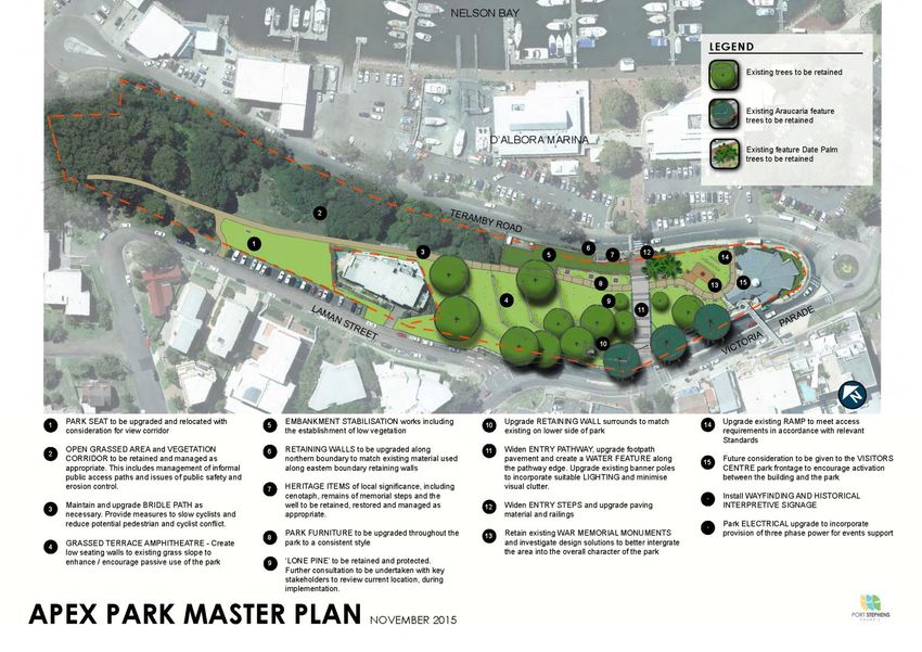
FIGURE 1 – Summary of Implementation Plan

  Key:

  Short – 1 year following the adoption of the Strategy.
  Medium – 1-3 years following the adoption of the Strategy.
  Long – 3-5 years following the adoption of the Strategy.

  No     Action                                                                         Timing
  Design Excellence
  1      LEP Clause for Activated Street Frontages                                      Short
  2      LEP Clause for Appropriate Vertical to Horizontal Proportions                  Short
  3      An Independent Urban Design Panel                                              Short
  4      Education Program on Urban Design                                              Short
  5      Support for Awards that recognise Design Excellence                            Short
  6      Develop a 3D model of the Town Centre for assessments                          Short
  Building Heights
  7      LEP Clause for FSR and increase in HoB                                         Short
  8      Adoption of LEP Clause 4.6 Policy                                              Short
  9      Expansion of the Strategy Boundary to include ridgelines                       Short
  Development Incentives
  10     Reducing the uncertainty provided by development incentives                    Short
  11     DCP requirements to encourage design excellence                                Medium
  Public Domain
  12     Development of a Public Domain Plan                                            Medium
  13     Utilise technology to activate the town centre and improve the resident and    Short
         visitor experience
  14     Feasibility assessment for public Wi-Fi in town centre                         Short
  15     Removal the Stockton Street Stage                                              Medium
  16     Review the Nelson Bay Foreshore Plan of Management (PoM)                       Medium
  17     Implement the Apex Park Masterplan                                             Long
  18     Develop a toolkit for public events                                            Short
  19     Audit facilities that are required to facilitate public events                 Medium
  Transport and Parking
  20     Update the Traffic and Transport Study and develop an Integrated Plan          Medium
  21     Identification of future car parking options                                   Short
  22     Formation of a Citizens Panel for short-term and long-term parking             Short
  23     Extension of Yacaaba Street                                                    Short
  24     Undertake a capacity analysis of the Victoria Street Pedestrian Bridge         Medium
  25     Review signage and parking metres on the Foreshore                             Medium
  26     Review road speed limits in the town centre                                    Medium
  27     Design and fund intersection options based on Study                            Medium
  28     Implement the Pedestrian Access and Mobility Plan (PAMP)                       Medium
  Implementation
  29     Re-word the existing actions to be SMART                                       Short
  30     Implementation Panel that meets regularly to discuss Strategy progress         Short
  31     Review Infrastructure Funding                                                  Medium
  32     Include relevant infrastructure items in the Strategic Asset Management Plan   Short
  33     Monitor, Report and Review the Strategy                                        Long

                                                                                                 6
Part One - The Review
The Need for a Review
Since its adoption in 2012, the Nelson Bay Town Centre and Foreshore Strategy (the Strategy) has
sought 'to guide Nelson Bay towards becoming more attractive to tourists, the business community and
residents'. Unfortunately, six years on from its adoption, there has been limited private investment in the
town centre and foreshore, despite this period being one of significant growth for the housing industry.
The transition of the Port Stephens Local Environmental Plan 2013 (the LEP) – the legislative tool that
details town planning regulations – into a standard instrument LEP has also meant that a number of the
actions originally identified within the Strategy would not have achieved the same intent, if legislatively
applied.
This comes from the recognition that LEP (Clause 4.6 – Variation of Development Standards) can be
tailored to have the same effect as the previously proposed clauses relating to design excellence. These
factors, in addition to the following short comings, led to the development of the 'Discussion Paper –
Progress of the Nelson Bay Town Centre and Foreshore Strategy' (the Paper):
Development standards, such as heights are not informed by development feasibility
Limited local policy guidance on the variation of development standards
Floor space incentives, despite Floor Space Ratios (FSR) not being included in the LEP
A development contributions levy based on commercial development, despite the significant
growth in commercial development being at the nearly centre of Salamander Bay
Lack of detail relating to the type and structure of the proposed Independent Urban Design Panel
The Strategy boundary not accounting for existing building height along dominant ridge-lines
Revised development controls (for example, private open space) under State Environmental
Planning Policy No.65 – Design Qualify of Residential Apartment Development
No clear reporting requirements against the identified actions
Further to this, the release of the Hunter Regional Plan on 14 October 2016 raised the importance of the
Tomaree Peninsula for land-use planning in the Hunter by identifying Nelson Bay as a ‘strategic centre’.
Hunter Regional Plan 2036
The Hunter Regional Plan (the Plan) identifies the role that Nelson Bay will play over the next twenty
years from the perspective of the State. The Plan makes the following mentions of Nelson Bay:
Determine the potential to grow allied health services on land around hospitals and health
services at Nelson Bay and other locations (p.29).
Create a compact settlement. In locations with good access to public transport and services, it
makes sense to identify new opportunities for redevelopment and renewal. Greater Newcastle,
coastal areas, including Nelson Bay has potential for this type of development (p.54).
Nelson Bay and Raymond Terrace are identified as 'strategic centres' (p.64).
Priorities for the 'strategic centre' of Nelson Bay are as follows:
a. Maintain it as one of the primary tourist centers for the region and a hub of the Tomaree.
b. Maintain retail and professional services for the surrounding communities.
c. Investigate opportunities for high-density development that maintains and enhances the
tourist, recreational and residential appeal of the centre.
7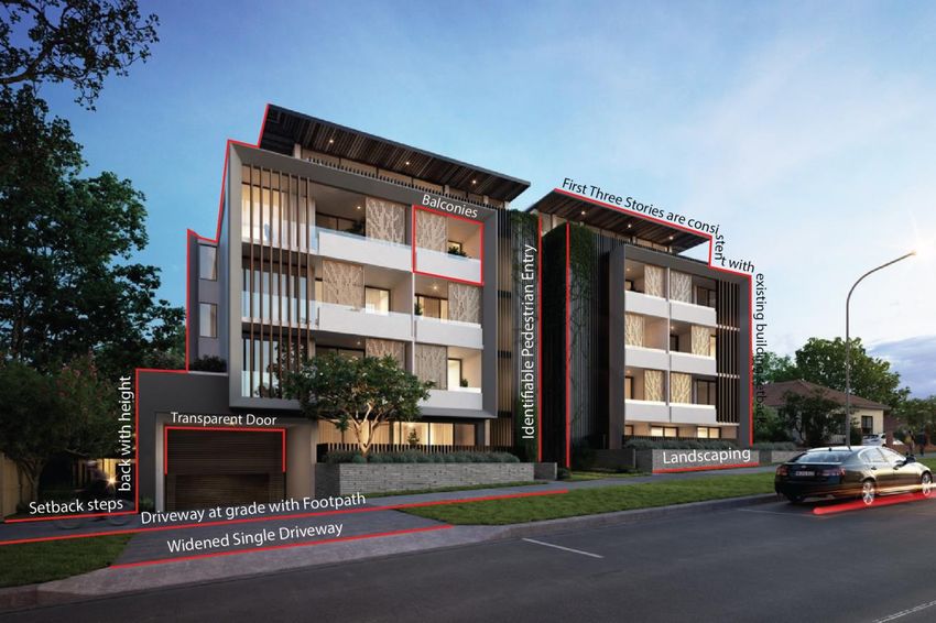
d. Balance the mix of permanent residential and tourist accommodation to enhance the
vibrancy and appeal of the centre and surrounds.
From this, it can be seen that Nelson Bay is a primary tourist centre for the region. It has a role in
facilitating higher density development, especially given its existing infrastructure and access to services.
These identified short comings of the existing Strategy and the updated State position provided by the
Plan led to the development of the Discussion Paper – Progress of the Nelson Bay Town Centre and
Foreshore Strategy (the Paper). The Paper was endorsed for public exhibition on 13 December 2016.
Discussion Paper – Progress of the Nelson Bay Town Centre and Foreshore Strategy (the Paper)
In developing the Paper, a focus was placed on understanding what actions had been implemented to
date. It identified that five years on from the adoption of the Strategy, Council has:
Developed five options for the extension of Yacaaba Street. The fifth option was endorsed by
Council on 24 June 2014 and construction commenced in late 2017.
Developed an Apex Park Masterplan, which was endorsed by Council on 8 December 2015.
Developed a site specific chapter within the Port Stephens Development Control Plan 2014 for
the Nelson Bay Town Centre and Foreshore, which was endorsed by Council on 14 July 2015.
Applied for and were successful in receiving $340,000 in ‘black spot funding’ for 2015/16 in
relation to the road and associated pedestrian works on Victoria Parade.
Identified and is currently leasing land for two temporary parking stations – one located on
Yacaaba Street, and the other on Government Road. The closure of the top two levels of the
Donald Street East multi-storey car park reduced parking capacity from 174 spaces to 60.
However, the temporary stations provide 120 spaces.
Facilitated the Woolworths Development, which has been a catalyst for economic activity in the
town centre. This approval also resulted in an additional 137 public car spaces.
Facilitated events, such as the Sacred Tree Markets, Tastes at the Bay and New Year’s Eve.
Council led ‘Smart Arts’ program led to Artisan Collective setting up on Magnus Street.
Approved four applications in the study area, only the Golf Course has been constructed.
The last point about the number of approvals and only one enactment – which was an insurance case
related to the Golf Course – identified the need for further investigation in order to understand why no
private investment was taking place. This led to the engagement of a third-party who undertook feasibility
testing for five residential development sites. This testing made the following market observations:
Costs of an excavated basement carpark are approximately $50,000 per single car bay and an
above ground car park is approximately $25,000.
Construction costs significantly increase from a level of eight storeys (28m) due to the need for
increased structural materials and regulations, such as fire sprinklers.
Modest unit pricing (gross realisations) is achieved in the current market.
A lack of foreshore (frontage) development sites where a high ratio of units has an ocean view
and generate the highest prices, capital rates ($/sqm of living area) and profit margin.
This testing was subsequently peer reviewed by a local third-party land-use economist who agreed that,
whilst there are a number of factors to consider the existing strategy is unlikely to allow for any significant
re-development in the existing market conditions and within any near future.
8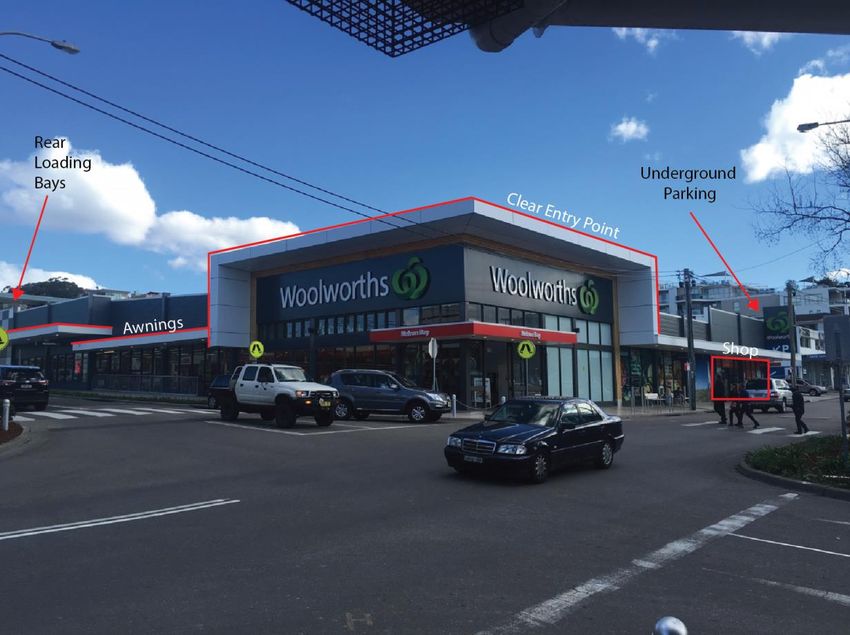
This lack of confidence in the town centre has led to limited new residential redevelopment and limited
population growth. From a Council perspective, this means it has been unable to collect development
contributions or new rates to fund the identified works. In turn, it has had to look towards other funding
sources, such as a grant to fund the Tomaree 'Black Spot’ Works and a $1.5M loan for Yacaaba Street.
From a community perspective, this leads to increased frustration due to the ‘tired’ public realm and
limited convenience services.

These observations highlighted the fact that if redevelopment has not occurred in a relatively robust
residential property market then the town centre may be waiting a few more property market cycles before
it will likely see any significant change desired by the local community. This is why the Paper identified
the need for changes.

Document Hierarchy

The Nelson Bay Town Centre and Foreshore Strategy (the Strategy) provides further detail to the Port
Stephens Planning Strategy, which implements the Hunter Regional Plan 2036.

This document represents the 'Progressing the Nelson Bay Town Centre and Foreshore Strategy – A
revised Implementation and Delivery Program' (the Delivery Program). Its role is to update and set the
implementation program for the Strategy. It replaces the 'Nelson Bay Town Centre & Foreshore
Improvement Program' and overrides the Strategy where any inconsistencies may exist.

The Strategy Hierarchy is best summarised by the following illustration (FIGURE 2).

                                                                                                             9
FIGURE 2 – Strategy Hierarchy
10Part Two - The Way Forward
Improving the Strategy
Part Two outlines how the Strategy can be improved by addressing the following six key themes:
1. Design Excellence
2. Building Heights
3. Development Incentives
4. Public Domain
5. Traffic and Parking
6. Implementation and Case Management
The headings provided under each theme are as follows:
1. Description of the theme
2. A Review of the theme
3. Suggested changes listed in the Paper
4. Summary of feedback received
5. Recommendations
112.1 Design Excellence
What is Design Excellence?
Design excellence is the recognition that building design should positively contribute to the overall quality
of a town and to provide buildings that are appropriate to their context. In some circumstances, this
contribution may be a landmark building, but more typically it is a well-designed building that fits into the
street. The following figure identifies some elements relevant to achieving design excellence.
FIGURE 3 – Illustration of Design Excellence
Key features of this example of design excellence include:
Appropriate block width, which then allows for side setbacks that cater for light infiltration and
deep soil landscaping which softens the overall appearance of built-form.
Entrances to the building are at the same level as the street to allow for easy access.
An identifiable pedestrian entry makes it easy for visitors and emergency services to locate.
Building height should provide due consideration to human scale. That is, five storeys is between
15-20m building height, which is a 1:1 ratio with a street width of 20m.
The consistent building setback for the first three storeys, and a further setback for the fourth
storey, reduces the overall bulk and scale of the development.
The front setback is utilised for landscaping that softens the overall built form.
Front balconies provide passive surveillance to the streetscape. At the same time, privacy
screens block direct overlooking into those private living spaces from public spaces.
12 Materials and colours of the driveway are consistent and are at grade with the public footpath,
which makes it more easily accessible and usable for wheelchairs, mobility scooters, bikes, etc.
The transparent garaged door reduces the ‘blank wall’ appearance that is typical of garage doors.
A wider single driveway allows for safe ingress and egress, while not reducing kerbside parking
or creating increased conflict points that comes from allowing two access points.
Kerbside parking is clearly marked to ensure the driveway is not blocked by parked cars.
The colour scheme is drawn from the existing colours of neighbouring buildings.
Orientation of windows allow for maximum solar exposure and ventilation.
Services (e.g. power) are placed underground or screened (e.g. A/C Units).
Design of the building reflects its use.
While it is recognised that not all development has the privilege of a flat site, particularly in Nelson Bay,
the principles of good urban design can still be applied. These principles can be grouped under the
headings of context, built form, density, sustainability, landscape, amenity, safety, housing diversity and
aesthetics. These principles result in buildings that are more livable and in turn more valuable.
A Review of Design Excellence
A review of current built form in the town centre, including development undertaken since the Strategy
and LEP have been in place identified that these design elements are not demonstrated on a regular
basis. The development that was reviewed resulted in the following observations:
Narrow lot width (less than 15m) and lot length (less than 30m) results in tall skinny structures
Monotone colours and consistent materials result in a lack of visual interest.
Minimal side setbacks remove opportunities for landscaping and light penetration. They also
reduce the potential privacy of buildings on neighbouring lots.
Consistent square pocket windows reduce opportunities for passive surveillance.
Lack of landscaping or opportunities for landscaping hardens the appearance of the structure.
No footpath to the front door reinforces the dominance of motor vehicles.
Roof-top balcony to extremity of side boundaries creates potential for overlooking.
Pitched roof is in contrast to the overall structure and neighbouring unit buildings.
Service entries next to the main entry door reduce overall aesthetics and amenity.
From this, it can be seen that the current planning regulations may not be producing the most desirable
urban design outcomes. A table summarising the development controls that apply to development defined
as a residential flat building and commercial premises was developed to inform this Paper.
This table identifies that detailed guidance is provided to common elements, such as heights, setbacks
and protection of view corridors. However, shortfalls are identified in the identification of activated street
frontages, minimum horizontal to vertical proportions and encouraging design excellence. From this, a
number of ideas to improve the design excellence of development were identified.
Suggestions for a better Strategy detailed in the Paper
Amending the LEP to ensure identified streets provided activated street frontages
Amending the LEP to ensure appropriate vertical to horizontal proportions
An independent external urban design panel to encourage design excellence
Education program for urban design
Support for awards that recognise design excellence
13Summary of feedback received on design excellence
Submissions in favour of promoting design excellence supported the ideal, but at the same time
recognised that it was very subjective. The submissions supported Council continuing to encourage
development that exhibits design excellence. This can be achieved through the existing framework (e.g.
Apartment Design Guide) and driven by the market demands of purchasers.
Recommendations
1. LEP Clause for Activated Street Frontages
It is recommended that a Planning Proposal be prepared to insert an activated street frontages
clause and accompanying map into the LEP.
This clause will seek to provide activation to those identified streets in order to achieve good
design outcomes. The Nelson Bay Woolworths is an example of a building that provides an
activated street frontage.
Good urban design features for the Nelson Bay Woolworths (FIGURE 4) are identified as follows:
Central location in the town centre supports existing specialty shops.
Clear identifiable entry point on the street corner encourages pedestrian activity.
Pedestrian crossing provides direct access from different sides of the street.
Lack of internal shops means specialty stores are not taken away from the streetscape.
Underground parking means floor level space is not given to parking.
Underground services clean up aesthetics and provides spaces for landscaping.
Continual awning coverage provides protection from elements, such as rain and sun.
Rear separate loading bays reduce potential conflict with pedestrians and cars.
An activated street frontage requirement will mean all new developments will have to ensure the
ground floor premises facing the street are to be used for the purposes of business premises or
retail premises. This could include amusement centres, community facilities, educational
establishments, entertainment facilities, function centres, information and education facilities,
medical centres, public administration buildings, or indoor recreation facilities. This will create a
lively centre with an amenable and pedestrian-focused public domain, activated by building uses
that engage with the street.
2. LEP Clause for Appropriate Vertical to Horizontal Proportions
It is recommended that a Planning Proposal be prepared in insert an appropriate vertical to
horizontal proportions clause and accompanying map into the LEP.
This clause will apply to those lots within the town centre with a width less than 15m and a length
less than 30m, which is identified by (FIGURE 5). This clause will seek to ensure the
consolidation of narrow and short lots and in turn avoid the high and narrow lots that have been
considered undesirable, but are currently encouraged by the controls contained in the LEP.
143. An Independent Urban Design Panel
It is recommended that Council commence the process to establish a local Independent Urban
Design Panel in accordance with the Apartment Design Guide. The Panel can be referred
development applications not just in Nelson Bay, but across the LGA. It may also may also
provide advice on development control plan amendments or other projects where expert input
can improve design outcomes.
FIGURE 4 – Illustration of the Nelson Bay Woolworths
The Strategy suggested that large developments should be considered by an urban design panel
in order to facilitate improved development outcomes. The role of an urban design panel is to
provide independent expert advice on development that is lodged with Council. SEPP No 65 –
Design Quality of Residential Apartment Development details how these panels are formed.
Council does not currently have an urban design panel, but currently utilises panels from other
Local Government Areas. It is proposed that the following development be referred to this Panel:
Residential flat buildings
Seniors housing
Industry, storage facilities and warehouses over 2,000sqm
15 Commercial premises over 2,000sqm
Development in the strategic centres that seek to vary development standards
Hospitals, schools or places of public worship
The above is generally consistent with that of Newcastle City Council. A review of past
development application data evidences that a total of seven applications would be referred per
year. This would mean an addition $3,000 in fees for the applicant and an additional estimated 30
days for the application to be processed by Council.
4. Education Program on Urban Design
It is recommended that an education program on urban design be scoped and funded for Council
Officers.
Continued education and learning is critical for all those involved in assessments will improve
design outcomes. An annual internal education program has been scoped and will commence
once the Delivery program is adopted. Education will focus on the revised SEPP No.65 –
Apartment Design Guideline and the role of urban design in contributing to the creation of great
places (i.e. place making).
5. Recognising and celebrating Design Excellence
It is recommended that Council actively recognise and support design excellence in and around
Nelson Bay Town Centre.
Initiatives like the Lower Hunter Urban Design Awards (LHUDA) is a good example of a local
initiative that seeks to recognise design excellence. The Paper listed the developments that have
been recognised.
From this, it was clear that over the twenty-five years that Council have been involved in the
awards, the only developments on the Tomaree Peninsula that have been recognised are two
single detached residences at Soldiers Point.
Recognising and celebrating design excellence can be effective in prioritising and raising the
profile of good design outcomes throughout the town centre.
6. Develop a 3D digital model of the town centre
It is recommended that Council commission a digital 3D model of the existing town centre using
digital aerial mapping for use by assessment staff.
The tool will be able to be used by assessment staff to support better decision making. Where
possible, imagery in appropriate formats provided by applicants will be able to be inserted in the
model to enable better assessments of bulk and scale, overshadowing and other impacts.
Applicants may be required to supply data and updates to the model in accordance with
specifications in the development control plan, assessment guidelines, or as part of requirements
for referrals to the Urban Design Panel.
16FIGURE 5 – Identification of Activated Street Frontages and Lots less than 15m by 30m
172.2 Building Heights
What is Building Height?
Height limits are important because they help shape the character of an area. For example, in areas
where only dwelling houses are permitted, lower maximum building heights are applied. By comparison,
in areas where residential flat buildings (i.e. units) are permitted and great density is expected, taller
building height limits apply.
Building heights influence the visual and physical experience of place and can reinforce the character of
an area or express community aspirations for an area’s future character.
The maximum Height of Building (HoB) is listed as a development standard under the LEP. This
development standard assists in shaping desired character (i.e. urban form, protection of identified view
corridors, human scale, the pedestrian experience, over-shadowing and property values). HoB is also a
key input that restricts floor space and in turn development feasibility.
A Review of Building Height
A review of the existing building heights has reinforced that the five storey limit has applied over the past few
decades. This can be seen to be reflective of the HoB limit contained within the LEP, which is based on the
recommendations within the PSC 1984, ‘Tall Building Study’ and reinforced through the more recent Strategy.
Despite this, there are a number of existing structures/approvals that exceed this height limit, being:
71 Victoria Parade, Nelson Bay (Commercial & Residential) – 6 Storey/21m
5B Tallean Road, Nelson Bay (The Landmark) – 8 Storey/28m
14 Magnus Street, Nelson Bay (Residential) – 6 Storey/21m
11-13 Church Street, Nelson Bay (Residential) – 8 Storey/32m
29-45 Magnus Street, Nelson Bay (Marina Resort) – 6 Storey/22m
The identification of these approvals has highlighted the significant development that has taken place along the
two ridgelines that Magnus Street and Thurlow Avenue. It also identifies the need to provide some guidance
around the use of the LEP (clause 4.6 - Exception to development standards), which allows development to
provide justification for the variation of a development standard, such as HoB, through the DA process.
These guidelines should assist in providing greater transparency and community participation in their
development given that the existing development standards were developed following extensive consultation at
the strategic planning phase. At the same time, the revision and subsequent expansion of the Strategy
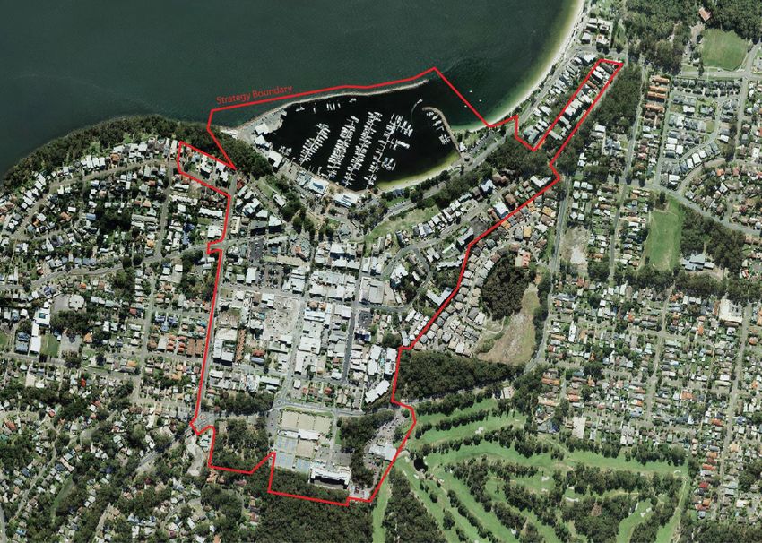
Boundary (FIGURE 6) will capture development that has already taken place along the ridgelines and can be
seen to be within a walkable distance (i.e. 400m) and cyclable distance (i.e. 800m) of the town centre.
In order to provide a more detailed understanding as to why there has not been any significant residential unit
development in the past ten years (FIGURE 7), Council engaged a consultant to undertake an independent
feasibility appraisal. The appraisal used 5 (17.5m), 8 (25m), 11 (32.5m), 14 (40m) and 17 (47.5m) HoB
scenarios for the five sites identified by (FIGURE 8). They are identified as:
Site 1 - 49, 51, 51A & 51B Stockton Street, Nelson Bay;
Site 2 - 11, 13 & 15 Church Street, Nelson Bay;
18FIGURE 6 – Extension of the Strategy Boundary
19FIGURE 7 – Development Consents and Unacted Approvals (1996-2006)
20FIGURE 8 – Five Sites Identified for Feasibility Testing
21 Site 3 - 36A to 36F Donald Street, Nelson Bay;
Site 4 - 15, 17, 19 & 19A Tomaree Street, Nelson Bay; and
Site 5 - 16, 18 & 20 Donald Street, Nelson Bay.
The methodology utilised for the feasibility assessment was based on the Urban Feasibility Model (UFM)
developed by the NSW Department of Planning and Environment. The independent feasibility assessment
made a number of market observations and sought to identify whether a developer would be able to achieve a
viable 20% profit margin in the current property market. A particular emphasis was placed on varying the
development height and Floor Space Ratios (FSR), as these standards significantly influence bulk and scale.
The Feasibility Appraisal makes a number of key market observations, including:
Costs of an excavated basement carpark are approximately $50,000 per single car bay and an
above ground car park is approximately $25,000.
Construction costs significantly increase from a level of eight storeys (28m) due to the need for
increased structural materials and regulations, such as fire sprinklers.
Modest unit pricing (gross realisations) is achieved in the current market.
A lack of foreshore (frontage) development sites where a high ratio of units has an ocean view
and generate the highest prices, capital rates ($/sqm of living area) and profit margin.
The following table (FIGURE 9) identifies at what point a 20% viable profit margin for a typical developer is
achieved and therefore may provide enough certainty to take the invest.
FIGURE 9 - Table summarising what conditions provide for a viable profit margin
Variable Site 1 Site 2 Site 3 Site 4 Site 5
Height 5 Storeys - 8 Storeys - 8 Storeys - 8 Storeys - The cost of
42 Units 51 Units 42 Units 60 Units replacing 140
public car
Parking Above Below Above Below spaces
Ground Ground Ground Ground renders the
Development Profit $4,026,073 $4,161,053 $5,017,193 $4,533,311 development
unfeasible.
Development Margin 24.39% 18.80% 24.62% 17.22%
Internal Rate of Return 21.70% 21.40% 38.77% 20.03%
Performance Ranking Viable Viable Viable Viable
Residual Land Value $1,588,727 $1,905,415 $2,200,584 $2,196,599
While the above table summaries what conditions provide for a viable profit margin the varying margins for each
site is best illustrated by the line graph provided as (FIGURE 10).
What these results indicate is that the feasibility of development is dependent on the individual characteristics of
each site. There is a high emphasis placed on the need to achieve water views as sale prices significantly
increase as a result, which translates into increased height in order to achieve this goal.
22FIGURE 10– Line graph illustrating the varying profit margins
40.00%
30.00%
20.00%
10.00%
Profit Margin
0.00%
3 Storeys 5 Storeys 8 Storeys 11 Storeys 14 Storeys 17 Storeys
-10.00%
-20.00%
-30.00%
-40.00%
Height and Parking (Above Ground)
Site 1 Site 2 - 11-13 Church St Site 3 - Donald St West
Site 4 - Tomaree St Site 5 - Donald St East
The cost of below ground parking means that above ground parking is favored. However, above ground parking
is often undesirable as it limits the potential for activated street frontages within commercial centres and places
parking at the same level of neighbouring residential buildings.
It is also well known that the residential unit market in Nelson Bay has been static and has actually declined
over the past ten years. This is due to a number of defaults and abandoned development sites stalling
development activity and causing poor developer sentiment. From the feasibility analysis, it is clear that current
conditions are not allowing for re-development. This is despite significant growth in the housing industry over
recent years. These observations have not only been made by the Independent Feasibility Report, but are
reinforced by the third party peer review by local economists located within Nelson Bay.
The graph on the following page (FIGURE 11) illustrates is that Nelson Bay experienced significant growth from
2000 to 2005, but this then dropped significantly. The market has still not recovered from that high in 2005 and
the resultant property market conditions have not allowed for feasible redevelopment to occur over the past ten
years, so the question is, what should be done with this information?
It is our belief that quality residential unit stock is required in order to provide confidence in the market and what
is required to make development feasible is water views. At the same time, maximum height requirements must
ensure that they do not come at the price of significant over-shadowing, loss of human scale and blocking of
views. In response, the following changes were suggested in the Paper.
23FIGURE 11– Line graph illustrating similar property markets
Median Unit Price (1991-2016)
600000
500000
400000
UNIT PRICE ($)
300000
200000
100000
0
1992
2000
2008
2016
1991
1993
1994
1995
1996
1997
1998
1999
2001
2002
2003
2004
2005
2006
2007
2009
2010
2011
2012
2013
2014
2015
year
Nelson Bay Kiama Forster
Suggestions for a better Strategy detailed in the Paper
Revising height limits and introducing a Floor Space Ratio (FSR) into the LEP.
Adoption of LEP Clause 4.6 Policy
Expansion of the strategy boundary to include ridgelines
Summary of feedback received on building heights
The majority of submissions received addressed building heights. Some were in support for a height
increase from the current height limits in the town centre, but the vast majority were against an increase
in height. Some of those opposed believed that five storeys were required in order to protect the existing
coastal village character. Other submissions supported a moderate increase in height (7 or 8 storeys)
and some submissions supported increasing heights and density in the town centre subject to maintaining
amenity and view sharing. Some of these issues have also been addressed in the discussion on
proposed development controls and development incentives.
It should be noted that, when the development application for an eight storey apartment building at 11-13
Church Street was considered by Council on 11 April 2017, the application received 75 submissions and
a petition containing 145 signatures in support of this development. Only two submissions objected. This
is an indication of support for increased heights where good design outcomes can be achieved.
24Recommendations
7. LEP Clause for Floor Space Ratios (FSR) and increase in Height of Building (HoB)
It is recommended that the maximum height of building and FSR be in accordance with the
following table (FIGURE 12), which is illustrated by (FIGURE 13).
FIGURE 12– Proposed HoB and FSR
No. Existing HoB Strategy HoB Proposed HoB Strategy FSR Existing FSR Proposed FSR
A 2 Storey (8m) Not in Strategy 2 Storey (8m) Not in Strategy No FSR No FSR
(No change) (No change)
B 2 Storey (8m) 3 Storey (10.5m) 3 Storey (10.5m) 2.5:1 No FSR 2.0:1
C 2 Storey (8m) 4 Storey (14m) 4 Storey (14m) 2.5:1 No FSR 2.0:1
D 5 Storey (15m) 7 Storey (24.5m) 10 Storey (35m) 2.5:1 No FSR 3.0:1
E No HOB 9 Storey (31.5m) 12 Storey (42m) 2.5:1 No FSR 3.0:1
F 5 Storey (15m) Not in Strategy 5 Storey (17.5m) Not in Strategy No FSR 2.5:1
Note: The Strategy (and this Delivery Program) makes allowance for a minimum 3.5 metres per storey.
The approach outlined by these figures is based on the following:
The Hunter Regional Plan 2036 identifies the need to ‘investigate high density
development that maintains and enhances the tourist, recreational and residential
appeal of the centre’ for Nelson Bay (p. 64). This approach is further supported by the
Port Stephens Planning Strategy 2011, which identifies that the intensification of existing
development is more suited than zoning further lands (p.20).
The Tomaree Peninsula is surrounded by national parks, which contain federally listed
endangered species, such as the koala. As a result, outwards expansion is constrained.
A town centre is the most appropriate location for density to cater for population growth.
Without this, Council will continue to see rezoning proposals on the periphery.
The Survey has identified that the Resident Owners, Resident Renters, Absentee
Landlords and Businesses did not reach mean agreement about the numerical maximum
height of building limit. However, they did reach mean agreement that building heights
should follow the natural slope of the land (p. vii).
The Paper identified that the town centre and foreshore has not seen any significant
residential development since 2006, despite a number of development consents being
issued. An extensive feasibility analysis, which was then peer reviewed identified that a
minimum of eight storeys was required to provide confidence for investment.
25 The development application for an eight storey apartment building at 11-13 Church
Street was considered by Council on 11 April 2017, and received 75 submissions and a
petition containing 145 signatures in support of this development. Only two submissions
objected to the development application. This is an extraordinary indication of support
for increased heights where good design outcomes can be achieved.
A number of existing buildings and approved development consents already exceed the
existing five storey maximum height of building limit, being:
o 71 Victoria Parade, Nelson Bay (Commercial & Residential) – 6 Storey/21m
o 5B Tallean Road, Nelson Bay (The Landmark) – 8 Storey/28m
o 14 Magnus Street, Nelson Bay (Residential) – 6 Storey/21m
o 11-13 Church Street, Nelson Bay (Residential) – 8 Storey/32m
o 29-45 Magnus Street, Nelson Bay (Marina Resort) – 6 Storey/22m
The overall bulk and scale of development will not just be determined by height, but the
introduction of FSRs that are likely to result in site coverage that is no greater than 38%
(HillPDA, 2017, p. 47). This means that developers have the confidence to invest, while
providing the majority of the site as open space and landscaping. FSR controls will also
limit the bulk and scale of development. With a proposed FSR of 3.0:1, there will be
significant scope for achieving 10 storeys in the town centre, particularly on the blocks
on the periphery of the centre such as between Church Street and Stockton Street. In
other areas of the centre, there will be some sites where a maximum 10 storeys will
never be able to be achieved with this FSR, based on current lot sizes and layouts.
26FIGURE 13– Illustration of proposed HoB and FSR
278. Adoption of LEP Clause 4.6 Policy
It is recommended that the Clause 4.6 Policy be adopted by Council.
Clause 4.6 of the LEP is a mandatory clause that all local councils must include in their LEPs.
The content and operation of Clause 4.6 cannot be amended or varied, however a local policy
can guide Council in the application of the clause and the processes that apply.
The NSW Government, 2011, ‘Varying Development Standards: A Guide’ discusses the
cumulative effects of varying development standards. For example, the variation of 7m (46%) for
the approved development at 29-45 Magnus Street, Nelson Bay (Marina Resort) set the
precedent for similar variations that have now occurred at the DA stage.
At the same time, the ability to vary development standards allows individual proposals to be
judged on their own merit. This is important given the sometimes broad brush approach that can
occur when developing a new comprehensive LEP across an entire Local Government Area.
A draft Clause 4.6 Policy was developed and placed on public exhibition with the Delivery
Program. The Policy seeks to provide greater transparency, community participation and more
robust assessments when a variation to a development standard is proposed. This is understood
to be the first of its kind in NSW. It accepts that this clause is a part of our planning system and
presents an innovative solution to mitigate perceived impacts.
Following exhibition the Policy has been amended to be strengthened, and it now provides that all
applications that seek to vary development standards by more than 10% are required to be
determined by the full Council.
9. Expansion of the strategy boundary to include ridgelines
It is recommended that the Strategy Boundary be amended in accordance with (FIGURE 6).
The existing Strategy Boundary focused on the commercial area of the town centre. It did not
recognise the significant development that has taken place along the dominant ridgelines of
Magnus Street and Thurlow Avenue. The existing development along these ridgelines is reflective
of the desire to obtain views of Port Stephens, while still being within walking and cycling distance
of the services that the town centre provides.
The expansion of the Strategy Boundary can be seen to be reflective of the existing maximum
building height of 15m, which is distinctively different from the maximum building height of 9m that
is applied to the majority of zoned land across the Tomaree Peninsula.
282.3 Development Incentives
The Strategy proposes that a variation of up to an additional two storeys (7m) and an additional Floor
Space Ratio (FSR) of up to 0.5:1 (2.5:1) for all sites in the town centre if a DA exhibited outstanding
design excellence and demonstrated a strategic public benefit (p.65).
Additionally, the Strategy proposed a FSR incentive of an additional 0.5:1 (3.0:1) for the following sites:
1. Seabreeze/Nelson Towers/Donald Street West Car Park Site
2. Coles Supermarket Site
3. Donald Street East Car Park Site
4. Fisherman’s Co-Operative Site
What is the purpose of development incentives?
Public Policy can usually achieve outcomes through one or a combination of the following avenues:
1. Education
2. Regulation
3. Financial Expenditure
Council encourages design excellence through education and by its continued commitment to the Lower
Hunter Urban Design Awards (LHUDA). It encourages the protection of view corridors through regulation
by setting a HoB limit and at the same time encourages redevelopment through investment in the public
domain, such as footpaths and trees.
While the above avenues seek to encourage desired outcomes that have been agreed by the community,
the generic regulatory development controls (i.e. HoB) do not take into account the individual
circumstances of each site.
For example, the incentive to re-develop a site that contains a heritage listed building accumulates as
land value and building maintenance increase over time. In recognition that heritage is a variable that
contributes to a desired urban character, development incentives, such as the City of Sydney – Heritage
Floor Space Scheme (HFSS) provides landowners who are responsible for the building maintenance with
floor space credits. These credits can then be sold to other sites seeking to exceed the height limit.
Examples of current local development incentives within Port Stephens include:
1. D11 – Raymond Terrace Centre is a specific part of the Port Stephens Development Control Plan
2014. This Part provides a 100% reduction in on-site parking requirements in order to encourage
redevelopment along King Street.
2. Clause 4.1D – Minimum Lot Sizes for Certain Split Zones, which is a clause under the LEP seeks
to allow for the subdivision of an undersized lot of environmental or agricultural significance and
provide it with a subsequent dwelling entitlement due to the understanding that the presence of a
dwelling leads to more active land management.
A Review of Development Incentives
The only development that has taken place in the town centre in the past ten years is the Woolworths on
the corner of Donald and Stockton Streets. The Strategy identified incentives for this site and the
developer did not draw upon them. This is likely to be a reflection of the increased construction costs that
come from additional storeys versus the known market return as identified in the feasibility analysis.
29Unfortunately, Nelson Bay’s position within the Hunter Region’s hierarchy of centres also means that it
may not be of a size where it is likely to receive buildings that are of architectural significance and
therefore incentives that seek to achieve this are misplaced. Buildings of architectural significance can be
seen to take place where multi-national corporations may be located; those of civic importance or where
residents are willing to pay a premium to purchase an apartment. Examples include:
1. University of Newcastle, City Campus - $95M
2. State of Law Courts, Hunter Street Civic, ten courts and two tribunal rooms - $94M
3. Icon Central Apartments, Hunter Street Civic, 262 Apartments - $150M
4. Arena Apartments, Watt Street, Newcastle East - $100M
These examples are all taken from the Regional City of Newcastle, which operates and is recognised as
a city that provides higher order services, such as health, law and financial. Nelson Bay plays a far
different role in relation to these services. Its major industry is tourism and in turn the most significant
development that can be seen to have taken place on the Tomaree includes:
1. Mantra Apartments, Tomaree Street, 161 residential units
2. Nelson Bay Bowling and Recreation Club, Dowling Street
3. Shoal Bay Resort and Spa, Shoal Bay
4. Birubi Point Surf Lifesaving Club, Birubi
Given that Nelson Bay is unlikely to attract buildings that are of a size and scale to display architectural
significance, it is proposed that the additional height and FSR be included as part of the development
standards for each site. This is given that they have already set an expectation for the market and the
feasibility analysis has indicated the need for a minimum of eight storeys to see redevelopment occur.
Suggestions for a better Strategy detailed in the Paper
The Paper made the following suggested changes to improve the Strategy:
Reduce the uncertainty that is provided through development incentives
Public goods, such as parking are provided by those who use it
Review of Development controls contained within the LEP and DCP
Summary of feedback received on development incentives
The discussion of this topic was understandably integrated with other themes, such as design excellence
and building height. Most of the discussion around this theme also focused on the use of LEP (Clause 4.6
– Variation of Development Standards). Some submissions would not accept that this Clause was a part
of the Standard Instrument LEP and Council could not remove or vary its application and use. It can only
seek to provide further guidance in relation to its use, which is provided through the Clause 4.6 Policy.
Recommendations
10. Reducing the uncertainty that is provided by development incentives.
It is recommended that the development incentives discussed in the Strategy are removed and
that HoB and FSR are inserted into the LEP in accordance with (FIGURE 13).
30These development incentives no longer form part of the Strategy. Any variation to modify a
development standard will be assessed in accordance with LEP (Clause 4.6 – Variation of
Development Standards) and the associated Policy.
11. DCP requirements to encourage design excellence
It is recommended that the DCP be amended to address the identified shortcomings.
The Port Stephens LEP and DCP were reviewed when Council transitioned to the Standard
Instrument template in 2014. A Housekeeping LEP was endorsed by Council on 1 August and a
Housekeeping DCP was also endorsed by Council for public exhibition on 24 October 2017.
Further recommendations to change the LEP to improve design outcomes have been discussed
under Part 2.1 – Design Excellence. The shortcomings of the DCP have been identified as:
Building depth
Building separation
Street setbacks, including upper storey set backs
Side and rear setbacks
Orientation
Public Doman interface
Communal and public open space
Urban Design Panel
It is recommended that new development controls should also establish objectives for upper
storey setbacks and floor plates which enhance the public domain and pedestrian experience by
preserving daylight access to the street level and creating a comfortable street environment, and
can achieve improved view sharing and visual privacy objectives. This will also address some of
the concerns expressed in submissions in relation to view corridors and view sharing as a result
of increased building heights.
A review of existing development controls for residential flat buildings and commercial buildings
has been undertaken. This review will inform future DCP amendments and placed on public
exhibition.
312.4 Public Domain
What is Public Domain?
The public domain includes the natural and built environment used by the general public on a day-to-day
basis, such as streets, plazas, parks and public infrastructure.
The objective of public domain is to create public spaces that people can enjoy. Quality public domain is
created through the application of tested urban design principles, such as street to height ratios, block
size or consistent streetscape materials. Investment in the public domain is generally understood as the
most significant contribution that Government can make towards providing business confidence and in
turn encouraging investment. It is a fundamental approach to economic development in urban spaces.
A Review of Public Domain
A review of the existing public domain in the town centre and foreshore identified the following:
Inconsistent pathway widths and materials
Missing pathway connections
Poor legibility resulting from poor signage and way finding tools
An inconsistent approach to street tree plantings and landscaping
Pedestrian barriers and incomplete street linkages
The Strategy identified a number of actions to address these shortcomings, such as the development of a
public domain plan or a street tree masterplan. However these actions were never undertaken at the time.
Quality public spaces are also essential considerations when planning for increased density in town
centres. Council has been successful in obtaining a grant to fund the preparation of a Public Domain
Plan, Wayfinding Strategy and Street Tree Masterplan. Identifying funding streams for this infrastructure
will be necessary to ensure these plans can be delivered. Private investment in the town centre can
provide public benefits by funding public domain works through developer contributions.
Suggestions for a better Strategy detailed in the Paper
Development of a Streetscape Design Guide for the Nelson Bay Town Centre
Detail provided to public domain works, costings and priorities
Revision of the Development Contributions Plan for the Nelson Bay Catchment
Summary of feedback on public domain
There was clear consensus that public domain mattered. Improving the public domain experience can
benefit both residents, businesses and visitors to Nelson Bay. Some submissions expressed a desire to
plan a public domain that expressed the unique coastal village and ‘natural amphitheatre’ character of
Nelson Bay.
Recommendations
12. Development of a Public Domain Plan
It is recommended that a Public Domain Plan be developed.
32The Paper identified the need to develop a Streetscape Design Guideline that would provide a
similar level of detail as the City of Ipswich, 2013, ‘Ipswich Streetscape Design Guideline – A
guide for Council, Developers and the Community’. Rather than just develop this Guideline, the
Public Domain Plan will address three matters relating to aspects of the public domain that were
identified in the Strategy, being: 1) Streetscape; 2) Wayfinding; and 3) Street Trees.
This action has already commenced and the draft Public Domain Plan, Wayfinding Strategy and
Street Tree Masterplan will be placed on exhibition following the adoption of the Delivery
Program.
13. Consider utilising technology to activate the town centre and public domain
It is recommended that Council incorporate ‘Smart City’ initiatives and utilise technology when
planning for the public domain and to improve the resident and visitor experience.
This could include investing in ‘Smart Parking’ initiatives (vehicle sensors or smart phone apps)
and an interactive digital platform that integrates maps, websites, digital wayfinding signage and
destination information for Nelson Bay.
14. Feasibility assessment for public Wi-Fi in the town centre
It is recommended that a feasibility assessment be undertaken for public Wi-Fi. Public Wi-fi and
digitisation of the town centre can help support the visitor economy and also encourage people to
stay longer in public spaces.
On 13 June 2017, Council agreed to investigate the feasibility of public Wi-Fi for the Nelson Bay
and Raymond Terrace town centres. The indicative pricing for implementation, associated risks
and ongoing management costs for public Wi-Fi services in these town centres was reported to
Council on 12 December 2017. The report recommended Council apply for relevant grant funding
opportunities to support the implementation of a public Wi-Fi service in Port Stephens. These
opportunities will continue to be pursued.
15. Remove the Stockton Street Stage
It is recommended that the Stockton Street Stage be removed.
16. Review the Nelson Bay Foreshore Plan of Management
It is recommended that the Nelson Bay Foreshore Plan of Management (PoM) be reviewed with
consideration provided to the updated actions of the Strategy and this Delivery Program.
The Department of Lands (former title), 2008, ‘Nelson Bay Foreshore Plan of Management’ was
developed in 2008 in coordination with Port Stephens Council. This PoM anticipated the
impending Strategy, but was unable to achieve any integration because the PoM was finalised
before the Strategy was completed. The next review of this PoM should take into consideration
the updated actions of the Strategy and Delivery Program.
33You can also read