South East river basin district Flood Risk Management Plan 2015 to 2021 Habitats Regulation Assessment - March 2016 - Gov.uk
←
→
Page content transcription
If your browser does not render page correctly, please read the page content below
South East river basin district
Flood Risk Management Plan 2015
to 2021
Habitats Regulation Assessment

March 2016

                   1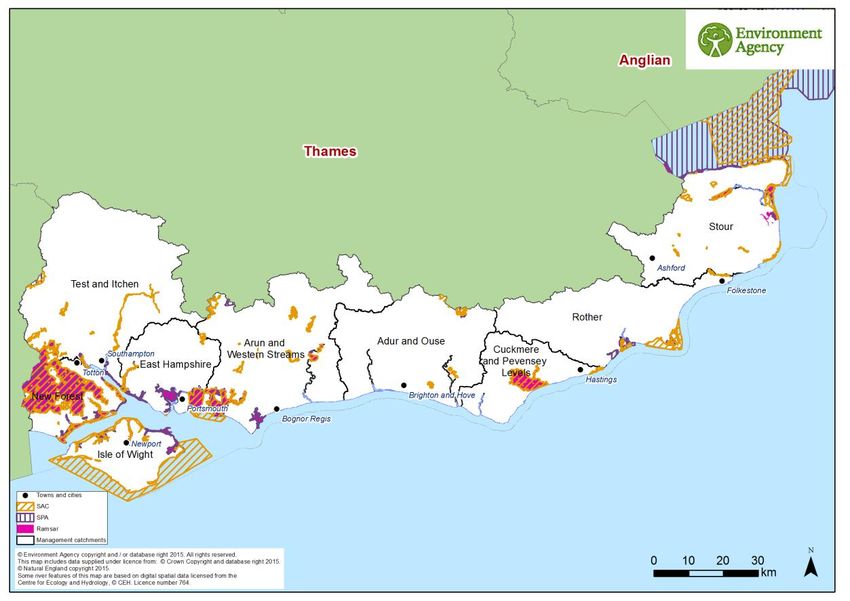
Executive summary
The Flood Risk Management Plan (FRMP) for the South East River Basin District (RBD)
provides an overview of the range of flood risks from different sources across the nine
catchments of the RBD and more specifically from local flood sources in the one Flood Risk
Area (FRA) of Brighton and Hove. The one FRA was identified as having higher local flood
risk by the Preliminary Flood Risk Assessments. The RBD catchments are defined in the
River Basin Management Plan (RBMP) and based on the natural configuration of bodies of
water (rivers, estuaries, lakes etc.).

The FRMP provides a range of objectives and programmes of measures identified to
address risks from all flood sources. These are drawn from the many risk management
authority plans already in place together with a range of further strategic developments for
the FRMP ‘cycle’ period of 2015 to 2021. The range of measures in the South East RBD
FRMP, are reported under the following types of flood management action:

Types of flood management measures                                                 % of RBD
                                                                                   measures
Prevention – e.g. land use policy, relocating people at risk etc.                       15%
Protection – e.g. various forms of asset or property-based protection                   48%
Preparedness – e.g. awareness raising, forecasting and warnings                         26%
Recovery and review – e.g. the ‘after care’ from flood events                            7%
Other – any actions not able to be categorised yet                                       4%

The purpose of the HRA is to report on the likely effects of the FRMP on the network of sites
that are internationally designated for nature conservation (European sites), and the HRA
has been carried out at the level of detail of the plan. Many measures do not have any
expected physical effects on the ground, and have been screened out of consideration
including most of the measures under the categories of Prevention, Preparedness, Recovery
and Review. Others that may have effects but are in catchments that do not have any
designated European sites have also been screened out of consideration.

Risk Management Authorities (RMAs) have for a long time been addressing the range of
flood risks through a range of plans and actions. Much of the South East RBD FRMP
presents measures that are ongoing from existing plans, which have already been subject to
HRA. RMAs have considered the effects of these existing plan measures on European sites
in published HRAs where required. These measures, their effects and agreed actions to
mitigate the effects have been summarised under relevant RBD catchments and FRAs
within this report. Where RMAs have identified new flood risk management priorities for the
next FRMP cycle period between 2015 and 2021, then the measures to implement these
have been considered alongside existing plan measures in this HRA.

The following table summarises the numbers of measures that the HRA has considered: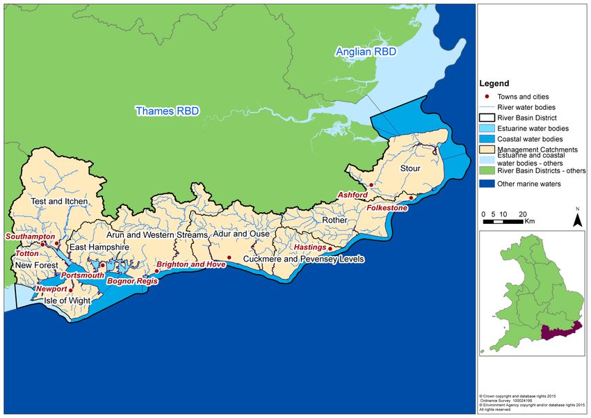
FRMP RMA plans                         Screened out         Measures from              New cycle 1
                                                                                                     1
                                              measures           existing plans             measures
    SE RBD catchments                                138                     119                         28
    FRA Brighton and Hove                               5                       4                         0
                            Total              143 (48%)              123 (41%)                28 (10%)

The HRA has been carried out for the set of measures for each RBD catchment that address
main river, sea and reservoir flooding alongside any measures volunteered by RMAs that
address local flooding and thus form a ‘RBD plan’ within the FRMP. Measures within FRAs
that address high risk of local flooding in these areas have been considered in the HRA as
separate ‘FRA plans’ within the FRMP. Both ‘RDB plan’ and ‘FRA plans’ are further
considered in-combination by the HRA. The findings are a summary of the risks to European
sites and an indication of the need for future HRAs at a project level when developing local
actions, as well as considering how to avoid and mitigate any residual risks to European
sites.
For the South East RBD FRMP, the main conclusions from the stages of assessment across
the 2 RMA plans of the FRMP are as follows:

A determination was made to screen out measures that would not have physical effects on
any European sites.

The effects of the measures from existing plans include effects of measures to address
coastal flooding from SMPs, measures to address main-river flooding from CFMPs and
measures to address local flooding from local strategies. Existing controls and mitigation
from these plans include: for SMPs, development of coastal strategies, accompanied by
more detailed HRAs for relevant SMP Policy Areas; and for CFMPs and Local Strategies
more detailed appraisal and assessment on plans or projects arising out of the plans to
demonstrate meeting the requirements of the Conservation of Habitats and Species
Regulations 2010, as amended (Habitats Regulations).

The effects of the measures that are for new flood risk management priorities for the next
FRMP cycle period of 2015 to 2021 have been considered within this strategic-plan level
HRA as far as they can be assessed at this high level. This HRA considers the range of
mitigation options that may be applicable. It is concluded that the measures are expected to
be able to be avoided or mitigated as part of their development as local actions, and all
measures have been identified as capable of being fully mitigated. It can therefore be
concluded that at the plan level there is sufficient scope for ensuring no likely significant
effects during its implementation. The detail of the controls and mitigation required will be
assessed as part of requirements to meet consents under planning and other consenting
mechanisms as part of a project level HRA, some of which may need to proceed to
appropriate assessment in order to gather the necessary level of detail.

The HRA considers the potential for in-combination effects with other plans and projects.
Given the level of information currently available, the assessment has identified the plans
where the greatest risk of in-combination effects occur, but a detailed assessment can only

1
  Measures across several catchments are counted up for each catchment for HRA purposes which may be a
different figure than reported in the FRMP.
be undertaken at the project level when details of location and design of measures are
known. Key external plans to consider for in-combination effects are:
Local Plans – plans of local planning authorities to determine consent for proposed
developments including FCRM ‘Protection’ types of development and which require
HRA for developments affecting European sites
Water Resource Management Plans – plans to manage the supply of water to
communities by Water Companies.
River Basin Management Plans – plans that seek to ensure the objectives of water
dependent European Sites are maintained.
Marine Plans – plans to manage the sustainable use of marine resources for inshore
areas.
This HRA does not remove the need for HRA at a subsequent level, i.e. lower tier strategies,
plans or projects that implement measures. This plan-level HRA does not give any weight to
subsequent lower-tier plans or projects and their HRA outcomes.
As local actions are developed at a project level and the details of their scope and scale are
known, this may identify additional effects on European sites that have not been assessed
here, or were not appropriate to consider at this spatial scale of plan.
CONTENTS

1     Introduction .................................................................................................................... 6
    1.1     Introducing this report ............................................................................................. 6
    1.2     Background to the FRMPs ...................................................................................... 7
    1.3     The South East RBD FRMP .................................................................................... 7
    1.4     Background to Habitats Regulations Assessment ................................................... 9
2     European sites in the South East RBD......................................................................... 11
    2.1     European sites that could be affected by the FRMP.............................................. 12
    2.2     European sites and their status for FRMPs ........................................................... 12
    2.3     European sites and their management.................................................................. 13
3     Approach to the HRA ................................................................................................... 15
    3.1     Description of the FRMP programmes of measures .............................................. 15
    3.2     Screening and Likely Significant Effects................................................................ 16
    3.3     Screening out catchments where no European Sites are present ......................... 16
    3.4     Screening out measures that would not have physical effects .............................. 16
    3.5     Considering measures from existing plans ............................................................ 17
    3.6     Considering new measures for FRMP cycle 1 ....................................................... 18
    3.7     Considering the need for further stages of assessment ........................................ 18
4     South East River Basin District Catchments HRA ........................................................ 20
    4.1     Summary of Measures .......................................................................................... 20
    4.2     Screening and Likely Significant Effects................................................................ 22
    4.3     Consideration of results and conclusion ................................................................ 45
5     Brighton and Hove Flood Risk Area HRA ..................................................................... 49
    5.1     Summary of Measures .......................................................................................... 49
    5.2     Screening and Likely Significant Effects................................................................ 50
6     In combination effects with other plans and projects .................................................... 52
    6.1     RBD and FRA FRMPs .......................................................................................... 52
    6.2     In-combination effects between RBD FRMPs ....................................................... 53
    6.3     In-combination effects with external plans ............................................................. 53
7     Conclusion and Future HRAs ....................................................................................... 56
Annex A:             Table A1 – HRA screening table for the FRMP measure categories

                     Table A2 – Management catchments and European sites in the SE RBD

                     Table A3 – Mitigation and control measures
Annex B:             SE RBD European sites
1 Introduction
1.1 Introducing this report
This report sets out the results of a strategic plan-level Habitat Regulations Assessment
(HRA) into the likely significant effects on designated ‘European sites’ of the Flood Risk
Management Plan (FRMP) for the South East River Basin District, published in December
2015. The HRA report has been prepared by the Environment Agency on behalf of the
collective Risk Management Authorities (RMAs) that have responsibilities for information
being published within the FRMP, and are thus the ‘competent authorities’ for the HRA of
their respective published information, as follows:
Information on flooding from main river, sea and reservoirs being published for the
catchments of the river basin district (RBD) are the responsibility of the Environment
Agency (for English catchments).
Information on flooding from local sources being published for any Flood Risk Area
(FRA) is the collective responsibility of Lead Local Flood Authorities within the FRA.
In preparing the HRA report the Environment Agency has consulted with Natural England
(for English catchments) and Natural Resources Wales (for Welsh catchments). The Lead
Local Flood Authorities in Flood Risk Areas are ‘competent authorities’ for HRA of their
FRMP information and have agreed that this report will meet their HRA requirements.
FRMPs are new strategic plans for implementing the Flood Risk Regulations 2009 and the
existing National Flood and Coastal Erosion Risk Management (FCERM) Strategy for
England. They have been developed for each of the River Basin Districts (RBDs) and Flood
Risk Areas (FRAs) and draw together information from a range of existing strategies and
plans that are in place and continue to be maintained by Risk Management Authorities. The
HRA has been carried out at the level of detail published in the FRMP and takes into
account HRAs that have already been undertaken for measures in existing plans, and at the
level of detail provided by these existing plans. Whilst a HRA at this strategic level cannot
obtain the level of detail necessary for in-depth assessment, the HRA summarises the likely
risks and potential need for controls and mitigation and the range of generic mitigation
options available, which will then proceed through further consideration once measures are
developed as specific local actions. In this way, this high-level HRA will be helpful for future
HRAs that consider the effects on European sites at a project level.
The report describes each of the main stages and results of the FRMP HRA as follows:
Describing the network of European sites within the RBD (chapter 2)
The approach to the HRA (chapter 3)
Screening and assessing likely significant effects (chapters 4,5)
Appropriate assessment, alternative solutions and imperative reasons of overriding
public interest (IROPI) (chapters 4,5)
Conclusion and future HRAs (chapter 7)1.2 Background to the FRMPs Flood risk management plans (FRMPs) highlight the hazards and risks from rivers, the sea, surface water, groundwater and reservoirs and set out how risk management authorities, such as the Environment Agency and local authorities, will manage flood risk. They are required by the European Union Floods Directive and the Flood Risk Regulations 2009. The FRMPs must be reviewed and reissued every six years to describe progress. The Environment Agency is required to prepare FRMPs for all of England covering flooding from main rivers, the sea and reservoirs. Lead Local Flood Authorities (county councils and unitary authorities) must prepare flood risk management plans for flood risk areas (there are ten flood risk areas in England) where the risk of flooding from local sources is significant as identified in Preliminary Flood Risk Assessments. The 2015-2021 period will be the first cycle of the FRMPs, however RMAs already plan for flooding and a large proportion of the FRMP measures are taken from existing plans that have already been consulted on and published. This includes plans such as Catchment Flood Management Plans (CFMPs) and Shoreline Management Plans (SMPs) as well as Local Flood Risk Management Strategies that have been developed by local authorities. Some further strategic developments have been included for the 2015-2021 first cycle of the FRMP that build on existing plans and seek to address the key objectives of the Flood Risk Regulations 2009, such as: strengthening joint working of RMAs, developing more integrated management of the water environment, and updated priorities from any new understanding of flood risks including the implications of climate change. 1.3 The South East RBD FRMP The South East River Basin District covers an area of 10,500km2 and includes the counties of Hampshire, East and West Sussex. It also includes about half of Kent and parts of Wiltshire and Surrey. The river basin district comprises nine catchments. The coastline of the River Basin District is varied and has many iconic features. These include the dramatic cliffs around Beachy Head, Dover and the Seven Sisters in East Sussex, as well as the natural harbours of Langstone, Portsmouth and Chichester. There are broad expanses of sand and dunes near Rye and Camber and the famous pebble beach and piers of Brighton. The Isle of Wight is a unique feature within the River Basin District and even with its relatively small coastline has all of the wider catchments features, including the iconic Needles on the West of the Island, the marshes at Bembridge and the sandy beaches at Sandown. The majority of the basin drains into the English Channel with the exception of the Stour which discharges into the North Sea. Some of the individual catchments still retain much of their natural character, whereas others have been significantly modified over time as a result of industry, navigation and agriculture. Parts of the South East River Basin District are heavily urbanised with a population of more than 3.7 million. Major urban centres include Brighton and Hove, Portsmouth, Southampton and Ashford.
In recent years there has been notable flooding across the basin, with severe flood events
occurring in the autumn of 2000, winter of 2008, summer of 2012 and again during the winter
storms of 2013/14. These flood events had significant impacts on some communities,
businesses and infrastructure as well as the natural environment. With a changing climate it
is predicted that there may be more extremes in the weather, leading to more frequent and
severe events like these.
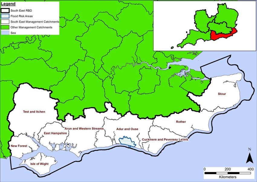
The South East RBD is made up of 9 management catchments (see map in Figure 1 below).
Figure 1: South East RBD catchments and Flood Risk Area
The South East RBD FRMP sets out the objectives and measures that have been drawn by
risk management authorities from existing plans or newly developed for the FRMP cycle
period of 2015-2021. Existing measures in the South East RBD FRMP are derived from the
following source plans:
Shoreline Management Plans (SMP)
Catchment Flood Management Plans (CFMPs)
Local Flood Risk Management Strategies (FRMS) developed by LLFAs.
The FRMP is divided into the separate plans that are the responsibility of different risk
management authorities, as follows:
Measures within the 9 RBD catchments of the South East RBD that the Environment
Agency is responsible for, and Measures within the Brighton and Hove Flood Risk Area (FRA) for local sources of
flooding that fall within the Adur and Ouse catchment. Brighton and Hove Unitary
Authority are responsible for these measures.
1.4 Background to Habitats Regulations Assessment
In England, the Conservation of Habitats and Species Regulations 2010, as amended,
commonly termed the Habitats Regulations, implements the European Union Habitats
Directive (Directive (92/43/EEC) on the Conservation of natural habitats and of wild flora and
fauna, and certain elements of the Wild Birds Directive (2009/147/EC). This legislation
provides the legal framework for the protection of habitats and species of European
importance in England.
Sites protected under the Habitats Regulations comprise Special Protection Areas (SPA),
Special Areas of Conservation (SAC), candidate SACs (cSAC), Sites of Community
Importance (SCI) and, as a matter of government policy, to potential Special Protection
Areas (pSPA) and Ramsar sites (sites designated under the 1971 Ramsar Convention for
their internationally important wetlands). These sites are referred to collectively as in this
report as ‘European sites’.
Regulation 9(3) of the Habitats Regulations requires that a ‘competent authority’ must
consider the requirements of Habitats Directive in exercising any of its functions. Article 6(3)
of the Habitats Directive defines the requirements for assessment of plans and projects
potentially affecting European sites. This requires that a competent authority, before
deciding to undertake, or give any consent or authorisation for a plan or project which is
likely to have a significant effect on a European site, and is not directly connected with or
necessary to the management of that site, must carry out an appropriate assessment. The
term commonly referred to for the assessment process is ‘Habitats Regulations
Assessment’.
The SE FRMP is considered to fit within the definitions of a ‘plan’ as defined by the Habitats
Directive, and requires a Habitats Regulations Assessment (HRA). The FRMP is a high-
level planning document for the SE River Basin District (RBD) (see map in Figure 1),
therefore potential impacts of the plan on European sites across the RBD are difficult to
determine. Given the geographic scale and nature of the plan, the HRA has been tailored to
be appropriate for the spatial area of coverage and the strategic nature of the plan.
The Habitats Regulations Assessment has followed a framework of four distinct stages, only
moving to the next stage if required by the results of that stage of the assessment. The four
stages are:
Stage 1: Screening and Likely Significant Effects is the process which initially identifies
the likely impacts upon a European Site of a plan or project, either alone or in combination
with other plans or projects, and considers whether these impacts may be significant. This
stage also includes the development of mitigation to avoid or reduce any possible effects.
Stage 2: Appropriate Assessment is the detailed consideration of the impact on the
integrity of the European Site of the plan or project, either alone or in combination with other
plans or projects, with respect to the site’s conservation objectives and its structure and
function. This is to determine whether there is objective evidence that adverse effects on theintegrity of the site can be excluded. This stage also includes the development of mitigation to avoid or reduce any possible effects. Stage 3: Assessment of alternative solutions is the process which examines alternative ways of achieving the objectives of the plan or project that would avoid adverse impacts on the integrity of the European Site, should avoidance or mitigation be unable to avoid adverse effects. Stage 4: Assessment where no alternative solutions exist and where adverse effects remain is made with regard to whether or not the plan or project is necessary for imperative reasons of overriding public interest (IROPI) and, if so, of any required compensatory measures.
2 European sites in the South East RBD
Within the South East RBD there are 36 SACs, 14 SPAs, and 11 Ramsar sites. Some of the
sites have more than one designation such as Arun Valley, parts of which are designated as
SPA, SAC and Ramsar. There is a proposed extension and name change to one SPA and
proposed Ramsar which is currently with Defra (‘Dungeness to Pett Level’; proposed name
change to ‘Dungeness, Romney Marsh & Rye Bay SPA’ and proposed Ramsar site of the
same name). This name change has not resulted in the SPA being double counted within
the FRMP. There is also a proposed marine SPA and Ramsar site which is currently being
consulted upon (Solent and Dorset Coast SPA). The proposed Ramsar and marine SPA are
included in the figures provided above. Figure 2 shows a map of the South East RBD with
the European sites and the management catchments of the SE RBD.

Figure 2 - Map of the European sites in the South East River Basin District

Although most of the European sites contain a variety of habitat types, broadly speaking they
could be described as coastal and marine sites and freshwater sites (comprising rivers such
as the Itchen SAC and wetlands such as the Pevensey Levels SAC and Ramsar). The
terrestrial sites are much smaller in area in comparison and generally comprise habitat such
as woodlands and grasslands.

Natura sites include Sandwich Bay SAC, which is a long sweeping inlet of the sea between
Ramsgate and Deal. The coastal area consists of sand flats with their associated salt
marshes and coastal sand dunes. The Sandwich Flats stretch for about five miles (8 km)
along the coast.
Dungeness SAC and Dungeness to Pett Level SPA, is of international conservation
importance for its geomorphology, plant and invertebrate communities and birdlife. The
proposed Ramsar site includes the entire SPA (including proposed extensions) as well as
additional areas of grazing marsh, drainage channels, canals, shingle beaches, sand dunes
and ponds.

The coastline along the west of the district is heavily designated with international
designations for birds and their habitat including Solent and Southampton SPA/Ramsar site,
Solent Maritime SAC and Portsmouth Harbour SPA and Ramsar site. It also contains
important wetland sites such as Chichester and Langstone Harbour SPA and Ramsar and
Solent and Isle of Wight Lagoons SAC.

The Pevensey Levels SAC and Ramsar is a large low lying area, which drains to the sea.
Water level management is fundamental in helping to restore and maintain the site in
favourable condition. The Ramshorn Snail and Fen Raft Spider are supported. The
freshwater mollusc Anisus vorticulus is a European Protected Species whose range is very
restricted – largely being confined to the Arun Valley and Pevensey Levels, which are SAC
designated.

The River Itchen is a SAC. The geology (chalk and sandy beds based) make this lowland
catchment an important haven for wildlife within which many SAC species are found
including salmon, native crayfish, southern damselfly, otters, bullhead, lamprey and water
voles.

Annex B contains a summary of the European sites present within South East RBD. Table
A2 in Annex A presents a summary of the European sites present within the management
catchments of the South East RBD. In a number of cases European sites cross over the
boundary of two or more management catchments, therefore a number of European site
names / designations may appear against more than one management catchment.

2.1    European sites that could be affected by the FRMP
The South East FRMP is a long term plan for the water environment, which could potentially
affect both water dependent and non water-dependent European sites and their qualifying
features.

It is not possible from the outset to rule out, at the RBD scale, any (water-dependent or non
water-dependent) European sites from being affected by the South East FRMP. The HRA
(in particular Sections 4.2 and 5.2 for the FRA) reviews the European sites by management
catchment, and determines whether any of the measures within the catchments are likely to
lead to significant effects on European sites.

2.2    European sites and their status for FRMPs
The South East RBMP provides summary information on the current status and baseline for
water-dependent European sites as part of its monitoring data.

European sites in England, with the occasional exception, are also designated as SSSIs.
Natural England monitors the conditions of SSSIs and their component units using six
reportable condition categories: favourable; unfavourable recovering; unfavourable no
change; unfavourable declining; part destroyed and destroyed.
The current status of water-dependent European site protected areas for the South East
RBD is summarised in table 1 below. This gives the current area of water-dependent SSSI
units of European protected areas in different condition categories as currently recorded on
Natural England’s designated site data system. SSSI units underpin European protected
areas and Natural England only collects data at a SSSI unit level. When SSSI units are in
favourable condition, they are deemed to be meeting their conservation objectives.

The table shows that for the South East RBD, 45% of water-dependent SSSI units of
European protected area sites are currently not compliant with the condition requirements.

Table 1 Status of water-dependent European Sites based on assessment of SSSIs
units for the South East RBD (Extract from Natural England databases August 2015)

    Condition                             South East RBD (ha)
    Favourable                                    20,482
    Destroyed / Part destroyed                       0
    Unfavourable declining                          182
    Unfavourable no change                          406
    Unfavourable recovering                       15,875

    Total Area Unfavourable                       16,463

    % Unfavourable                                   45

2.3       European sites and their management
As part of a new strategic approach to managing all England’s European sites, new
measures needed to achieve favourable conservation status for all European sites in
England have been developed by Natural England in partnership with the Environment
Agency. These are collectively referred to as Site Improvement Plans (SIPs), and are being
developed by the Improvement Programme for England’s Natura 2000 sites (IPENS). SIPs
were published for all European sites in England in 20152.

With reference to relevant SIP’s for England's Natura 2000 Sites, common pressures on
units in the South East region transitional and coastal water bodies include water pollution,
air pollution resulting in atmospheric nitrogen deposition, invasive species and commercial
marine and estuarine fisheries. Coastal squeeze, changes in species distributions and direct
impact from 3rd parties are marginally less common. Whilst less common pressures include
inappropriate water levels and ditch management, scrub and weed control, recreational
marine and estuarine fisheries, public access/disturbance, overgrazing, change in land
management and physical modification. For freshwater sites common pressures include
water pollution, inappropriate water levels and ditch management, with less common
pressures including invasive species, inappropriate scrub and weed control, overgrazing and
public access/disturbance.

2
 Site Improvement Plans for the South East River Basin District can be found on:
http://publications.naturalengland.org.uk/category/6287197783195648
The South East FRMP recognises SIPs include actions where flood risk management is specifically a mechanism for their delivery. Measures from within the SIPs within the South East RBD have been considered as part of the development of measures within the RBMP, so that they will contribute to objectives for WFD Natura 2000 Protected Areas in the RBD.
3 Approach to the HRA
The steps undertaken to complete the HRA are as follows:
describe the plan and the measures proposed
screen and assess the likely significance of any effects on European sites
consider need for further stages of assessment (i.e. appropriate assessment,
alternative solutions and IROPI)
determine a plan-level conclusion
3.1 Description of the FRMP programmes of measures
The South East River Basin District Flood Risk Management Plan (FRMP) is a joint
publication of several plans required under the Flood Risk Regulations that are the separate
responsibilities of specific Risk Management Authorities (RMAs), as follows:
South East River Basin District catchments (Environment Agency)
Brighton and Hove Flood Risk Area (LLFA within the FRA)
3.1.1 River Basin District Catchments
FRMPs for the River Basin District (RBD) are being published by the Environment Agency
(for English catchments) and Natural Resources Wales (NRW) (for Welsh catchments), and
are focused on measures principally to address flood sources from main river, the sea and
reservoirs. The measures have been divided into catchments based on the River Basin
Management Plans (where they are called ‘management catchments’).
Production of the FRMPs for the RBDs is the legal duty of the Environment Agency and
NRW. Where any voluntary information on local sources of flooding within RBD catchments
has been provided by LLFAs, these are published by joint agreement in the RBD FRMP.
The Environment Agency and NRW are also the competent authority under the Habitats
Regulations for the RBD FRMPs.
3.1.2 Flood Risk Areas
FRMPs for Flood Risk Areas (FRAs) are being published by the Lead Local Flood
Authorities (LLFAs) where the FRAs lie within their administrative boundaries. Production of
the FRMPs for the FRAs are the legal duty of the respective LLFAs. The LLFAs responsible
for the FRA FRMPs are also the competent authority under the Habitats Regulations.
Where a RBD includes one or more FRA, as is the case for the South East RBD, the
measures that have been developed specifically for these FRA FRMPs are presented and
assessed separately.
3.1.3 Applying HRA
In applying the HRA process, each RMA plan has been assessed separately. A final
summary of conclusions and recommendations for future HRAs is provided that also draws
on a high-level summary of the potential for in-combination effects of the FRMP with other
key plans.3.2 Screening and Likely Significant Effects
This first stage of the HRA process requires consideration of screening and likely significant
effects of measures on European Sites. The tasks undertaken to complete this are as
follows, and set out in more detail below:
screening out catchments where no European Sites are present
screening out measures that would not have physical effects
considering measures from existing plans, with mitigation / controls already agreed in
HRAs for any likely significant effects, or in some cases potential adverse effect on
site integrity
considering new measures and their likely significant effects, with mitigation / controls
where considered necessary
conclusion from screening and likely significant effects.
The results of these tasks for each RMA’s plan of the FRMP are provided in the following
chapters:
Chapter 4: SE River Basin District catchments
Chapter 5: Brighton and Hove Flood Risk Area
3.3 Screening out catchments where no European Sites are present
Where there are no European sites present in a catchment, it was determined that no further
consideration of measures in the catchment is required. Given the level of detail in the plan
where the FRMP measures are mainly strategic in nature and are not specific on their
precise location, there is insufficient details to consider downstream or down drift effects
beyond the catchment. However, such screening for cross-catchment effects will be a
requirement in assessing local plans and projects.
3.4 Screening out measures that would not have physical effects
Every measure included within the FRMP is categorised according to one of the following 4
categories, accompanied by an M-code:
Prevention (M2) - reducing the impacts of flooding through land use and
development policy, relocation of assets at risk, or measures to divert the hazard to
avoid harm.
Protection (M3) - protecting people from the risk of flooding; for example, by the
maintenance, refurbishment of existing defences or building new defences.
Preparedness (M4) - by taking actions that prepare people for flooding; for example,
by improving awareness of flood risk, or by providing warning and forecasting for
floods.
Recovery and review (M5) - supporting recovery after flooding has happened and
reviewing how things can be improved; for example, by improving the availability of
recovery services such as providing temporary accommodation.
Other (M6) – measures not fitting in to any of the above categories.Further definitions of each of the measures are set out in the FRMP according to a second
tier of M-codes. For example, Prevention (M2) includes the second tier measure, M22, which
is defined as “Prevention, removal or relocation measure to remove receptors from flood
prone areas or to relocate receptors to areas of lower risk”. These measure definitions have
been used as the basis for the initial screening out of the measures that require no for further
consideration within the HRA.
The measure codes and their definitions are included as Table A1 (in Annex A to this
document). Measures under ‘Preparedness’ (M4) and ‘Recovery and review’ (M5) will not
result in development, demolition or changes of management ‘on the ground’ that could
result in effects on European Sites. These were therefore screened out from any further
consideration. Similarly, under the ‘Prevention’ category (M2), only the removal or relocation
of receptors from flood prone areas could potentially affect European sites. The measures
that have been screened in to the assessment are set out below and have been highlighted
in Table A1:
M22 – Prevention – removal or relocation (category)
M3 – Protection – all sub-categories
M6 – Other – not yet defined.
3.5 Considering measures from existing plans
Risk Management Authorities have a range of plans in place for developing and
implementing measures related to flooding from main river (in Catchment Flood
Management Plans), to flooding from the sea (in Shoreline Management Plans) and related
to local sources of flooding (e.g. in Local Flood Risk Management Strategies). These plans
have been subject to HRA where relevant, and have reported on the effects on European
Sites consistent with the level of detail of the plans.
For this HRA, these existing HRAs have been used to summarise the effects of measures
from existing plans that are now set out under specific RBD catchments or FRAs. For many
RBD catchments and FRAs there are multiple existing plans covering the geographic area
but also some existing plans that are split across RBD catchments or FRAs. Nonetheless we
have separated out the ‘screened in’ measures from individual existing plans and referenced
the specific HRA results that apply to them.
The results from existing HRAs have considered the extent that they remain valid since they
were published. This has been done by checking the status of the relevant European sites
that were considered within the source plan’s HRA for any changes to site designations
since the date of the HRA publication. The criteria were agreed with Natural England and
comprised: whether there were any new / additional site designations, any changes in site
boundaries, changes in designated site features, or any significant changes in site
conditions.
The HRA results from Shoreline Management Plans are relatively recent with most
published between 2010 and 2011. The HRA results from Catchment Flood Management
Plans are a little older with most published between 2008 and 2010. The HRA results from
Local Flood Risk Management Strategies are the most recent with the first ones being
published around 2012 and most being published much more recently.One of the main reasons for a likely change from when the effects of plan measures were
reported in HRAs is where there have been boundary changes to European sites or to the
scope of condition of the interest features of the sites i.e. specific habitats, species etc.
Where we have been advised that such changes have occurred and are significant then this
has triggered further consideration of the validity of the existing HRA results that we have
relied upon.
3.6 Considering new measures for FRMP cycle 1
In reviewing the range of measures across existing plans covering all sources of flooding,
Risk Management Authorities (RMAs) have taken the opportunity to put forward further
strategic developments for the next 6 year cycle of the FRMP. These ‘new measures’ focus
on: strengthening the joint working of RMAs across all flood sources; developing more
integrated management of the water environment as set out in the River Basin Management
Plans and other related plans; and updating flood risk information to help manage risks with
communities.
For this HRA we have reviewed the set of new measures that have been ‘screened in’ for
each catchment. As they are mostly ‘strategic’ measures without specific information on
location or the form of action that would be developed on the ground, we have considered a
range of factors that would give rise to any likely risks from this set of measures in a specific
catchment, which includes:
their general proximity in the catchment to European sites
whether they aim to address sources of flooding that are local, or main river or
related to the coast
the mix of types of new measures within the catchment denoted by their M-codes
(i.e. whether they are mainly maintenance, or channel works, or new solutions).
General proximity was considered by narrowing down the set of measures within a
catchment to those that were closer in general and more likely to be connected to European
sites by the hydrology of the catchment rather than applying specific buffer distances to
individual measures.
3.7 Considering the need for further stages of assessment
HRA steps were carried out for each RBD catchment of the RBD plan that is the
responsibility of the Environment Agency. Further HRA steps were carried out for each FRA
(by catchment) that is the responsibility of respective Lead Local Flood Authorities. The
determination for each catchment or FRA that there are no likely significant effects to
European sites, is based on the following assumptions:
that this HRA does not remove the need for HRA at a subsequent level, i.e. lower tier
strategies, plans or projects that implement measures, nor does it give any weight to
their outcomes. Consideration of potential impacts and options available to mitigate
for those impacts should assist, but not influence or constrain any lower-tier
assessments.
that as local actions are developed at a project level and the details of their scope
and scale are known, that this may identify additional effects on European Sites thathave not been assessed here, or were not appropriate to consider at this spatial scale of plan.
4 South East River Basin District Catchments HRA This chapter sets out the results of carrying out the HRA on the measures for the South East RBD catchments that are for flooding from main river, sea and reservoirs and for local flooding sources outside of Flood Risk Areas. This is the FRMP information for which the Environment Agency is the FRMP ‘statutory authority’ and HRA ‘competent authority’. The Flood Risk Area FRMP information for which other RMAs have responsibility has been considered separately in later chapters of the HRA (see sections 5 and 6). This section covers the following stages of the assessment: Summary of measures being assessed Screening and assessment of likely significant effects Consideration of results and conclusion 4.1 Summary of Measures The initial screening and assessment of likely significant effects reviewed the measures for each of the 9 management catchments within the SE RBD FRMP. Figure 3 - Map of the South East river basin district and management catchments A summary of the measures and their screening is given below for each catchment.
Table 2: Summary of measures by catchment

    Management                                                  Number of measures related to types                         Number of new measures and

                    Number of measures

                                         Number of measures

                                                                                                                                                            Number of European
                                         from existing plans1

                                                                                                      measures for cycle1
    Catchment                                                   of existing plans1                                          known level of detail1

                    screened in (out)

                                                                                                      Number of new

                                                                                                                                                            Sites
    Catchments with no screened in measures
    All catchments have some screened in measures.
    Catchments with all measures from existing plans
    Rother                       19            19 3 from CFMPs                                                       0                                      5
                               (13)               16 from SMPs
    Sub-total                    19            19 3 from CFMPs                                                       0
                               (13)               16 from SMPs
    % all                       7%            7%                                                       (n/a)
    measures
    Catchments with new measures for cycle 1 of the FRMP
    SE RBD          7 (15)                          0                                                            7          7 strategic/proximity unknown   61
    Wide
    Adur and        12 (8)                          9           2 from CFMPs                                     3          3 not in proximity              4
    Ouse                                                        7 from SMPs
    Arun and        22                         15               6 from CFMPs                                     7          6 not in proximity              18
    Western         (11)                                        9 from SMPs                                                 1 specific/in proximity
    Streams

    Cuckmere        19 (9)                     13               8 from CFMPs                                     6          6 not in proximity              3
    and                                                         4 from SMPs
    Pevensey                                                    1 from LLFA plans
    Levels
    Test and        8 (32)                          5           1 from SMPs                                      3          3 specific/in proximity         11
    Itchen                                                      4 from LLFA plans
    East            8 (14)                          7           1 from SMPs/other EA plans                       1          1 not in proximity              9
    Hampshire                                                   6 from LLFA plans

    Isle of Wight   2 (6)                           2           2 from CFMPs                                     0                                          7

    New Forest      3 (13)                          2           2 from SMPs                                      1          1 specific/in proximity         7

    Stour           47                         47               22 from CFMPs                                    0                                          16
                    (17)                                        21 from SMPs
                                                                4 from LLFA plans
    Sub-total       128                   100                   40 from CFMPs                               28
                                                                                                             16 not in proximity
                    (125)                                       45 from SMPs                                 7 strategic/proximity unknown
                                                                15 from LLFA plans                           5 specific/in proximity
    % all           45%                     35%                                                          10% 16 (6%) 7 (2%) 5 (2%)
             2
    measures
    Overall         147                   119   43 from CFMPs                                               28              see above
    Total           (138)                       61 from SMPs
                                                15 from LLFA plans
    % all           52%                     42% 43 (15%) 61 (21%) 15 (5%)                                10% see above
             2
    measures
1
   all numbers are of 'screened in' measures, except those in brackets
2
   all %s are of total of all 'screened in and out' measures
'in proximity' means being generally in the same part of the catchment (specific distances are not applied, but further detail is provided
in the assessment)
'specific' is where a measure is place specific, 'strategic' is where a measure is catchment or RBD-wide
3
  Measures across several catchments are counted up for each catchment for HRA purposes which may be a higher figure than
reported in the FRMP.
Of the total of 285 measures 52% have been screened in for HRA consideration (48%
screened out). All management catchments within the SE RBD have some screened in
measures and are considered further.
There are 22 measures that are RBD-wide and are considered in section 4.2.4.9.
There are no measures from neighbouring river basin districts that were included in SE RBD
catchments.
4.1.1 Risks from existing plan measures
42% of all FRMP measures (excluding Flood Risk Areas) are screened in and from existing
plans, 15% are from CFMPs and 21% from SMPs. Most risks are from SMP measures
where adverse effects identified in the SMP HRA for specific policy areas are being
addressed.
Most risks to European Sites that are being addressed by existing plans relate to the (21%)
measures in SMPs, and more specifically where the SMP is managing likely adverse effects,
such as in the catchments of Rother, East Hampshire and New Forest.
4.1.2 Risks from new measures
10% of all FRMP measures (excluding Flood Risk Areas) are screened in and new
measures, 2% are strategic without locations, 6% are not in proximity to any European Sites
and 2% are more specific improvements that are in proximity to sites. The most likely risks
will be related to the development of local actions for the specific improvements in the next
FRMP cycle and can be found in the Test and Itchen and New Forest catchment and to a
lesser extent in the Arun and Western Streams and Isle of Wight catchments.
4.2 Screening and Likely Significant Effects
The management catchments that make up the SE RBD FRMP are set out in table 3 below.
The colour coding in the table summarises the nature and source of the bundle of measures,
which forms the basis for how each management catchment has been assessed. The
following sub-sections consider each of the management catchments in turn.
Table 3 Management Catchments of the SE RBD /FRMP
Management Catchment Management Catchments
Category
Management catchments with no None
European Sites present.
Management catchments with no None
‘screened in’ measures.
Management catchments with all - Rother
measures from existing plans.
Management catchments with new - Isle of Wight - Arun & Western Streams
measures. - New Forest - Adur & Ouse
- Test and Itchen - Cuckmere & Pevensey Levels
- East Hampshire - Stour4.2.1 Management catchments with no European sites present
All management catchments within the South East RBD have European sites present,
therefore no management catchments have been ruled out of further consideration on this
basis.
4.2.2 Management Catchments with no ‘screened in’ measures
All management catchments within the South East RBD have screened in measures,
therefore no management catchments have been ruled out of further consideration on this
basis.
4.2.3 Management Catchments with all measures from existing plans
The following management catchments in the South East FRMP do not contain any FRMP
new measures; they contain only measures from existing plans.
This plan has already been subject to consultation and assessment, including HRA. The
HRA conclusions for those source plans have been referred to in each case.
4.2.3.1 Rother Management Catchment
European New measures Existing plan measures
sites
Screened in Screened out Screened in Screened out
4
0 0 19 13
The Rother management catchment contains 4 European sites. There are no new
measures within this catchment; all of the 32 measures are from existing plans.
There are eight measures which relate to public awareness and preparedness. There are
five measures which relate to recovery and review. These are screened out.
South Foreland to Beachy Head Shoreline Management Plan
One Rother District Council protection measure under the ‘Fairlight Cove coastal protections
works’ comprises works to increase the rock protection at the base of the cliffs to decrease
erosion is some 1km alongshore of the Hastings Cliffs SAC and 2km updrift of the
Dungeness to Pett Level SPA. The SMP identified no likely significant effect for this policy
unit due to distance from the European sites and the west to east drift direction.
One Environment Agency led protection measure for the replacement of Tillingham Sluice is
some 20km upstream of Dungeness to Pett Level SPA, proposed Ramsar and Dungeness
SAC. The Hythe Ranges Sea Defences is some 25km updrift of the Dover to Kingsdown
Cliffs SAC.
One Environment Agency led protection measure to enhance the operation and
maintenance of Marshlands Tidal Basin to the south of Dymchurch. This is some 4km
alongshore of the Dungeness SAC and proposed Dungeness, Romney Marsh and Rye Bay
SPA and Ramsar and some 30km updrift of the Dover to Kingsdown Cliffs SAC.One Shepway District Council led protection measure for shingle recycling from Folkestone to Hythe to maintain the existing sea defences, is some 15km updrift of the Dover to Kingsdown Cliffs SAC. One Environment Agency led protection measure for the Hythe Ranges sea defences, is some 15km updrift of the Dover to Kingsdown Cliffs SAC. One Shepway District Council protection measure comprises works to improve the Coronation Parade structure in Folkestone and prevent future cliff erosion is some 10k updrift of the Dover to Kingsdown Cliffs SAC One Environment Agency led ‘other’ measure is to assess the strategic requirement for habitat creation as a result of implementing short, medium and long term polices of the South Foreland to Beachy Head Shoreline Management Plan on European sites. This high level assessment is not likely to lead to significant effects. One Environment Agency led protection measure at Nook Point to Cliff End, under ‘Pett Shingle Recycling’ is an existing operation, which is subject to annual review with Natural England under the Habitats Regulations of potential impacts on the Dungeness to Pett Level SPA (including the extension), and proposed Dungeness, Romney Marsh and Rye Bay pRamsar. One Environment Agency led protection measure at Broomhill Sands under ‘The Broomhill Sands Coastal Defence scheme’ has already been consented following an assessment under the Habitats Regulations, which considered the pSPA extension and pRamsar as material considerations, with construction due for completion in December 2015. One Environment Agency led protection measure adjacent to Broomhill Sands which is the refurbishment of Jurys Gap Tidal Basin is currently undergoing consent under the Habitats Regulations with no Likely Significant Effect identified from the works. One Shepway District Council led protection measure for ‘Greatstone Dunes Management’ is within the Dungeness SAC. The measure comprises the ongoing maintenance of fencing to retain sand within the dune network to maintain stability, which is subject to existing agreement with Natural England and is considered not to have a likely significant effect on the European interest features. Three Environment Agency led protection measures comprised of Rother Tidal Walls East, Lydd Ranges Sea Defences and Romney Sands Sea Defences are currently being progressed together as a package subject to project level Habitats Regulations Assessment further to the Folkestone to Cliff End Coastal Defence Strategy IROPI case, regarding Dungeness SAC and the proposed Dungeness, Romney Marsh and Rye Bay pSPA and pRamsar. One Environment Agency led protection measure to continue maintenance of shingle recycling from the Denge Beach Management Plan at Dungeness to Jury’s Gap, is currently subject to annual agreement with Natural England. This has been considered within the consented Broomhill Sands Habitats Regulations Assessment and the consented Broomhill Sands Extension. The shingle recycling to Dungeness Power Station as part of the same measure is already consented as part of the current Denge Beach Management Plan which
is reviewed annually subject to consideration of potential impacts on Dungeness SAC and
the proposed Dungeness, Romney Marsh and Rye Bay SPA extension and Ramsar.
One Environment Agency led protection measures, ‘Littlestone beach recharge’ is for a
capital recharge which will be informed by the current Denge Beach Management Plan. This
site is within the proposed Dungeness, Romney Marsh and Rye Bay pSPA and pRamsar
and adjacent to the Dungeness SAC.
An Appropriate Assessment was carried out as part of the SMP. The Appropriate
Assessment concluded that implementation of the SMP:
may have an adverse effect on the integrity of the Dungeness to Pett SPA;
will have an adverse effect on the integrity of the Dungeness SAC;
will not have a likely significant effect on the Dover to Kingsdown Cliffs SAC,
Hastings Cliffs SAC or the Pevensey Levels Ramsar site;
will not have any adverse effects as a result of in-combination effects with other plans
and programmes.
Consequently, an application was made to the Secretary of State for Environment, Food and
Rural Affairs to consider the case for Overriding Public Interest. This case was accepted by
Defra who consequently confirmed that they had no objections to the intention to approve
the SMP. Compensatory measures are to be developed by the Regional Habitat Creation
Programme. Consideration of additional impacts on the pSPA and pRamsar will be a
material consideration in the development of the proposals and will be considered at the
project level.
Rother and Romney Catchment Flood Management Plan
Two existing protection measures are to undertake maintenance. One is to carry out in-
channel maintenance work such as weed cutting and desilting along the main river and
another measure to carry out maintenance of existing flood risk management assets,
including existing sluices, embankments, reservoirs, pumping stations, flood gates, and sea
defences are subject to existing agreements relative to the Dungeness to Pett Level SPA
and proposed Ramsar and Dungeness SAC about the mouth of the River Rother which are
reviewed annually with Natural England.
One Environment Agency led protection measure to investigate options to reinstate storage
of flood water within the flood plain of the Rother Valley may have effects on the Dungeness
to Pett Level SPA and proposed Dungeness, Romney Marsh and Rye Bay Ramsar. The
Rother and Romney CFMP HRA identifies that the increase in flooding that would occur in
the Rural Rother would be carried out via a managed approach and done in consultation
with Natural England.
The CFMP HRA, could not conclude that there will not be a likely significant effect on the
Dungeness SAC and Dungess SPA and Ramsar site. However, following an appropriate
assessment, it was concluded that the CFMP would not adversely affect the integrity of
the European sites.
Proposed Mitigation: Some existing measures cannot be put into effect until more detailed
appraisal and assessment has taken place at project level to show they have met therequirements of the Habitat Regulations, and to take account of the material consideration of
the pSPA and pRamsar.
Some existing measures are currently subject to project level HRA that is assessing the
detailed measures and identifying appropriate mitigation where necessary.
The Imperative Reasons of Overriding Public Interest (IROPI) for the FoCES requires that
appropriate compensatory habitat needs to be secured before the schemes under it can
progress. The conclusions need to be considered relative to the additional interest features
for the Lydd Ranges Sea Defences and Romney Sands Sea Defences resulting from the
proposed extension (and name change of the Dungeness to Pett Level SPA to the
Dungeness, Romney Marsh and Rye Bay), including the proposed Ramsar designation
which was not considered by the FoCES due to uncertainty on boundary at the time of its
writing.
4.2.4 Management Catchments with New Measures
4.2.4.1 Isle of Wight Management Catchment
European New measures Existing plan measures
sites
Screened in Screened out Screened in Screened out
7
0 3 2 3
The Isle of Wight management catchment contains 7 European sites. In total there are 8
measures for the catchment, 3 of which are new measures.
The water dependent European Sites present protect habitats including maritime cliff and
slope, coastal and flood plain grazing marsh, lowland heathland, saline lagoons, intertidal
mudflats, coastal sand dunes, intertidal flats and seagrass beds and coastal vegetated
shingle. The Solent and Southampton Water is designated as a Ramsar site and as a
Special Protection Area, as it supports internationally important numbers of wintering
waterfowl and various rare invertebrates and plants.
New measures
There are three new plan measures which relate to public awareness and preparedness.
These measures have been screened out of consideration of likely significant effect.
Existing measures – Isle of Wight Catchment Flood Management Plan (CFMP)
There are two existing measures which relate to prevention. These measures have been
screened out of consideration of likely significant effect.
One existing protection measure is located on the Lukely Brook, which is a tributary of the
River Medina, some 1km upstream of the Solent & Southampton Water SPA and Ramsar
sites and Solent Maritime SAC. The scope of the works includes consideration of upstream
flood storage, raised defences and property level protection.
One existing protection measure is on the Monktonmead brook, within Ryde on the north
coast of the Isle of Wight, adjacent to the Solent & Southampton Water SPA and RamsarYou can also read