Reserve Activity Plan 2018 - 2022 ACTON TRAILS AND RESERVES - Clarence City Council
←
→
Page content transcription
If your browser does not render page correctly, please read the page content below
Reserve Activity Plan
                        _______________________________________________________

                        2018 - 2022

            ACTON TRAILS AND RESERVES

   ADVICE PREPARED BY
        TASFLORA FOR
CLARENCE CITY COUNCIL
            JUNE 2018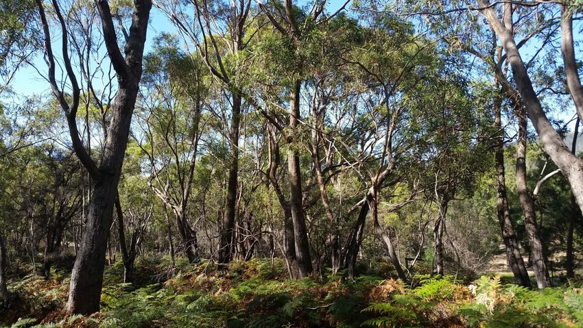
© Tasflora 2018.

This work is copyright. Apart from any use permitted under the Commonwealth Copyright Act
1968, no part (including the format, structure and style) may be reproduced by any process,
nor may any other exclusive right be exercised, without prior written permission from Tasflora.
Reserve Activity Plan 2018-2022                                                          Acton Trails and Reserves

CONTENTS

1     BACKGROUND ................................................................................................ 5

2     OBJECTIVES ................................................................................................... 5

3     SITE DESCRIPTION......................................................................................... 6

4     SITE VALUES................................................................................................... 6

4.1      Native flora .................................................................................................. 6

4.2      Native fauna .............................................................................................. 10

4.3      Cultural heritage ....................................................................................... 11

4.4      Recreational values .................................................................................. 11

4.5      Landscape setting and connectivity ....................................................... 12

5     STAKEHOLDER CONSULTATION ............................................................... 13

6     WEED MANAGEMENT .................................................................................. 13

6.1      Weed species present .............................................................................. 13

6.2      Recommendations for weed control work.............................................. 13

6.3      Maintenance weed control work.............................................................. 15

6.4      Non-priority weeds ................................................................................... 15

7     REGENERATION AND REVEGETATION ..................................................... 16

7.1      Regeneration ............................................................................................. 16

7.2      Revegetation activities ............................................................................. 17

8     FAUNA HABITAT MANAGEMENT ................................................................ 19

9     VEGETATION AND FAUNA MONITORING .................................................. 20

10 RESERVE ENTRANCES ................................................................................ 21

11 TRACKS AND TRAILS .................................................................................. 21

12 INFRASTRUCTURE ....................................................................................... 23

Tasflora, June 2018                                                                                                    3

Reserve Activity Plan 2018-2022                                                      Acton Trails and Reserves

13 SUPPORTING RECREATIONAL ACTIVITIES .............................................. 23

14 COMMUNITY PARTICIPATION AND AWARENESS .................................... 24

15 IMPLEMENTATION PLAN ............................................................................. 27

16 FUTURE PRIORITIES .................................................................................... 27

APPENDIX 1: CONSERVATION SIGNIFICANCE OF THE RESERVE’S NATIVE
FLORA AND FAUNA ............................................................................................ 33

APPENDIX 2: UNANTICIPATED DISCOVERY PLAN ......................................... 35

APPENDIX 3: SUMMARY OF STAKEHOLDER CONSULTATION ..................... 37

APPENDIX 4: DECLARED WEED SPECIES AND RECOMMENDED CONTROL
TECHNIQUES ....................................................................................................... 52

APPENDIX 5: SUMMARY OF ON GROUND MANAGEMENT
RECOMMENDATIONS ......................................................................................... 55

Tasflora, June 2018                                                                                               4

Reserve Activity Plan 2018-2022                                      Acton Trails and Reserves

1   BACKGROUND

The Clarence Bushland and Coastal Strategy, developed by Clarence City Council
(Council) in 2011, summarises plans and strategies relevant to reserves within the
Clarence municipality.1 A key recommendation derived from the Strategy was to
develop and implement reserve activity plans (RAPs) for all bushland and coastal
reserves managed by Council. To date, Council has developed and partially
implemented 20 RAPs within the Clarence municipality.2

The suburb of Acton on Hobart’s eastern shore encompasses a significant portion
of the Tangara Trail network as well as the 16 hectare Nowra Bushland Reserve.
Both are owned and managed by Council. The Tangara Trail network in this area
is valued by locals and visitors for the range of recreational opportunities that it
provides, and the trails and Reserve provide an attractive setting for locals and
visitors to traverse the Acton area away from road verges and traffic.

A bushfire management plan has been previously prepared for the Nowra
Bushland Reserve, and the trail network is encompassed by the broader Tangara
Trail Network Management Plan 2012-2017. 3 However no specific overarching
management plan detailing specific on-ground activities has previously been
prepared for the trails and reserves in the Acton area.

In this context, Tasflora has been engaged by Council to develop a five year
Reserve Activity Plan for on ground management activities encompassing the
Tangara Trails in the broader Acton region, the Nowra Bushland Reserve and the
proposed Single Hill Bushland Reserve 4 , including the development of an
implementation plan identifying immediate and ongoing management priorities to
be undertaken during the period 2018-2022.

The recommendations and actions contained within this Acton Trails and Reserves
Activity Plan 2018-2022 were endorsed by Council in June 2018, and are intended
to provide guidance for on ground activities that can be implemented by Council,
community groups and/or volunteers. It is acknowledged that it may not be
possible to undertake all recommended activities due to resource constraints;
rather the intent of this plan is to provide a guide to management concepts and
outcomes that could be achieved if sufficient funding can be obtained.

2   OBJECTIVES

The objectives of the Acton Trails and Reserves Activity Plan 2018-2022 are to:

    •   ensure the Reserves and trails are sustainably managed to preserve and
        enhance their natural, cultural and social values;

1
 https://www.ccc.tas.gov.au/webdata/resources/files/Clarence_Bushland_and_Coastal_Strategy.pdf
2
  Council’s Reserve Activity Plans are available at: http://www.ccc.tas.gov.au/page.aspx?u=1957
3
  http://www.ccc.tas.gov.au/webdata/resources/files/tangara_management_plan_2012-2017.pdf
4
  The proposed Single Hill Bushland Reserve is expected to be formally passed to Council
ownership during the five year period encompassed by this Plan.

Tasflora, June 2018                                                                         5
Reserve Activity Plan 2018-2022                                      Acton Trails and Reserves

      •    identify priority management activities to be undertaken along the trail
           network and within the Reserves by Council, community groups and/or
           volunteers as resources become available during the period 2018-2022; and
      •    encourage community engagement through raising awareness of the area’s
           values and encourage participation in activities to minimise threats to these
           values.

3     SITE DESCRIPTION

The area covered by the Acton Trails and Reserves Activity Plan 2018-2022 is
illustrated in Figures 1-2.

      •    Tangara Trails – the plan encompasses all the existing Tangara Trails in the
           Acton corridor, nominally bounded as follows: to the south by Roches Beach
           Road and Kirra Road; to the North by Alliance Drive; to the west by Tara
           Drive, Acton Drive and Acton Court; and to the east by Estate Drive and
           Acton Road.
      •    Nowra Bushland Reserve – approximately 16 hectares of bushland reserve
           to the north of Nowra Rd.
      •    Proposed Single Hill Bushland Reserve – this proposed area of public open
           space encompasses Single Hill immediately to the north of Nowra Bushland
           Reserve and is expected to be formally passed to Council ownership during
           the five year period encompassed by this Plan.

The Tangara Trail, Nowra Bushland Reserve and proposed Single Hill Bushland
Reserve are zoned as Open Space under the Clarence Interim Planning Scheme
2015.5

4     SITE VALUES

4.1       Native flora

Several native vegetation communities are present within the area covered by this
plan.

The Nowra Bushland Reserve is dominated by Bursaria-Acacia woodland and
scrub (TASVEG code NBA), and also contains small areas of
Eucalyptus amgdalina forest and woodland on sandstone (DAS), E. ovata forest
and woodland (DOV) and E. viminalis grassy forest and woodland (DVG). The
proposed Single Hill Bushland Reserve contains several vegetation communities
including Bursaria-Acacia woodland and scrub (NBA), E. viminalis grassy forest
and woodland (DVG), E. globulus dry forest and woodland (DGL) and lowland
grassland complex (GCL).6

5
 http://www.iplan.tas.gov.au/pages/plan/book.aspx?exhibit=claips
6
 North Barker Ecosystem Services (2007). Single Hill, Seven Mile Beach Vegetation Survey and
Fauna Habitat Assessment. Unpublished report for Johnstone, McGee and Gandy Pty Ltd.

Tasflora, June 2018                                                                            6
Reserve Activity Plan 2018-2022                                  Acton Trails and Reserves

                                                                                  N

Figure 1: Northern portion of area covered by the Acton Trails and Reserves Activity Plan
2018-2022 (map provided by Clarence City Council). Green highlighting indicates
Tangara Trail.

Tasflora, June 2018                                                                    7
Reserve Activity Plan 2018-2022                                  Acton Trails and Reserves

                                                                                    N

Figure 2: Southern portion of area covered by the Acton Trails and Reserves Activity Plan
2018-2022 (map provided by Clarence City Council). Green highlighting indicates
Tangara Trail and Nowra Reserve; dark hatched green highlighting indicates proposed
Single Hill Bushland Reserve.

Tasflora, June 2018                                                                     8
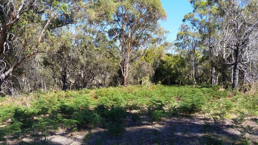
Reserve Activity Plan 2018-2022                                 Acton Trails and Reserves

An area of E. amgdalina forest and woodland on sandstone (DAS; refer Figure 3)
occurs along the Tangara Trail adjacent to Old Monmouth Track and Black
Peppermint Track (between Georgina Place and the “Five Ways” track junction
near Penelope Place). This community has been degraded to some extent due to
the clearing (without permission) in some areas to create bike tracks, runs and
jumps. A small patch of E. ovata forest and woodland (DOV) is present opposite
the junction between Tara Drive and Acton Road (refer Figure 4).

Figure 3: Eucalyptus amygdalina forest and woodland on sandstone adjacent to Black
Peppermint Track along the Tangara Trail.

Figure 3: Eucalyptus ovata forest and woodland along the Tangara Trail near the junction
between Tara Drive and Acton Road.

Tasflora, June 2018                                                                   9

Reserve Activity Plan 2018-2022                                       Acton Trails and Reserves

A description of each of these native vegetation communities is provided at
Appendix 1. Eucalyptus amgdalina forest and woodland on sandstone (DAS),
E. ovata forest and woodland (DOV) and E. globulus dry forest and woodland
(DGL) are listed as threatened native vegetation communities under the Nature
Conservation Act 2002.

Several threatened flora species listed under the Tasmanian Threatened Species
Protection Act 1995 and/or the Commonwealth Environment Protection and
Biodiversity Conservation Act 1999 have been previously recorded in the Nowra
Bushland Reserve and the proposed Single Hill Bushland Reserve. A summary of
these species is provided at Appendix 1.

4.2       Native fauna

The Reserve contains suitable habitat for a range of native wildlife (mammals,
birds, reptiles and invertebrates), including:

      •    mature or dead eucalypt trees with hollows which provide potential den and
           nest sites for possums, bats and hollow-nesting bird species, including the
           endangered swift parrot (Lathamus discolour) as well as the eastern rosella
           (Platycercus eximius) and musk lorikeet (Glossopsitta concinna), the latter
           two of which have been observed on Single Hill;7
      •    mature, flowering eucalypt trees that provide a foraging source for possums
           and birds, including mature Eucalypus spp. trees within the proposed Single
           Hill Bushland Reserve which may provide potential nesting and/or foraging
           habitat exists for the wedge tail eagle and the swift parrot (based on
           previous observations)8;
      •    open grassy woodland which provides a foraging source for small
           mammals, including the threatened eastern barred bandicoot (Perameles
           gunnii);
      •    shrubs and other understorey species that provide nesting, shelter and a
           foraging source for birds and small mammals; and
      •    fallen timber and leaf litter, which provide shelter and foraging habitat for
           small birds, reptiles and invertebrates.

The trails and reserves covered by this plan contains potential foraging and/or
nesting habitat for two threatened fauna species: the swift parrot and the eastern
barred bandicoot. Further information on these species is provided at Appendix 1.

Bird surveys have previously been undertaken over 15 months between April 2014
and June 2015 at two sites near Five Ways / Black Peppermint Trail.9 Forty five
woodland bird species were recorded during this period, with the most common
species present including the grey fantail (Rhipidura fuliginosa), superb fairy-wren
(Malurus cyaneus), little wattlebird (Anthochaera chrysoptera) and brown thornbill
(Acanthiza pusilla). The aggressive noisy miner (Manorina melanocephala) was

7
  M. Newman, pers. comm. January 2018.
8
  North Barker Ecosystem Services (2007). Single Hill, Seven Mile Beach Vegetation Survey and
Fauna Habitat Assessment. Unpublished report for Johnstone, McGee and Gandy Pty Ltd.
9
  Newman, M. (2015). Retention of native vegetation provides valuable habitat in acreage
developments. Tasmanian Bird Report, no. 37.

Tasflora, June 2018                                                                             10
Reserve Activity Plan 2018-2022 Acton Trails and Reserves
also amongst the ten most frequently recorded species, but was found to occur in
more open areas. The study concluded that most native woodland bird species
were using the study area opportunistically for short periods and that the remnant
native vegetation of the Tangara Trail appears to facilitate their movement between
the remaining patches of continuous woodland in the area, particularly in areas
with shrub and ground cover protection that provide shelter from more aggressive
species such as noisy miners.
More recent bird surveys undertaken in 2017 indicate that degradation of the black
peppermint woodland may have contributed to a reduction in woodland bird
species diversity and increased dominance of the noisy miner and introduced bird
species.10
4.3 Cultural heritage
The municipality of Clarence, including the Acton area, was previously occupied by
the Mumirimina band of the Oyster Bay tribe.11,12
Under the Tasmanian Aboriginal Relics Act 1975 (the Aboriginal Relics Act), it is an
offence to ‘destroy, damage, disfigure, conceal, uncover, expose, excavate or
otherwise interfere with a relic’ unless a permit has been granted. It is therefore
important to ensure that no Aboriginal artefacts or other cultural material are
exposed or disturbed without a permit during Reserve management activities. In
the event that an Aboriginal artefact is inadvertently uncovered, an Unanticipated
Discovery Plan should be implemented immediately (refer Appendix 2) and the
items reported to Aboriginal Heritage Tasmania for advice.
4.4 Recreational values
The Tangara Trail network in the Acton area was originally established as a
network of safe and easily accessible trails for local horse riders between large
subdivisions, bushland areas and coastal land.13 The Tangara Horseriding Trails
Inc. was established in 1988 as a management committee for the trail network and
has historically managed the trail network with support from Council.
As well as horse riding, the Tangara Trails and reserves in the Acton area are
utilised by locals and visitors for walking, jogging, dog exercise, cycling and
mountain biking. Community feedback indicated a preference for allowing each of
these activities to continue.
10
M. Newman, pers. comm., January 2018.
11
Alexander, A. (2003). The eastern shore: a history of Clarence. Clarence City Council, Rosny
Park.
12
Maynard, L. (2007). A report of an aboriginal heritage value assessment of a proposed
subdivision at Single Hill, Acton. Unpublished report for Toronto Pastoral, the Aboriginal Heritage
Office, DTAE and the Tasmanian Aboriginal Land and Sea Council.
13
Inspiring Place (2012). Tangara Trail Network Management Plan 2012-2017. Unpublished report
for Clarence City Council.
Tasflora, June 2018 11Reserve Activity Plan 2018-2022 Acton Trails and Reserves
4.5 Landscape setting and connectivity
Acton’s Tangara Trails and reserves provide an attractive setting for locals to enjoy
recreational activity and traverse the Acton area away from road verges and traffic,
thus providing an important recreational connectivity between the Canopus-
Centauri Bushland Reserve, Roches Beach and the Seven Mile Beach Coastal
Reserve.
The Acton Tangara Trail network provides the opportunity to develop and enhance
a wildlife corridor outside of private property. Connectivity between areas of
bushland provides an important ecological link for flora and fauna to enable gene
flow between populations and to allow animals to move across the landscape for
foraging, nesting and breeding. Direct linkages (which could be enhanced through
strategic revegetation and regeneration activities; refer Section 7) exist along the
Tangara Trails throughout Acton linking the Nowra Bushland Reserve, the
proposed Single Hill Bushland Reserve and native vegetation near the Five Ways
with the Canopus-Centauri Bushland Reserve, as well as indirect linkages via
vegetated private land with Mt Canopus and Mt Rumney (refer Figure 4).
Legend
Walking track linkage
Biodiversity linkage
Figure 4: Connectivity between the Acton trails and reserves and other bushland areas
(imagery sourced from the LIST).
Connectivity from a user perspective is currently very good, although community
consultation has indicated that some minor improvements could be made. These
are further discussed in Section 11. Importantly, the formal passing over of the
Tasflora, June 2018 12Reserve Activity Plan 2018-2022 Acton Trails and Reserves proposed Single Hill Bushland Reserve to Council will enable the formalisation of a direct recreational linkage between Acton and Seven Mile Beach (discussed further in Section 11). Landscape setting and connectivity are important for the long term viability of Clarence’s bushland areas as well as ongoing visual amenity and recreational opportunities within the municipality. It is important that these linkages be preserved and strengthened though strategic land use planning. 5 STAKEHOLDER CONSULTATION A public meeting and community ‘walk and talk’ session was facilitated by Council and Tasflora on 15 October 2017 and attended by 17 local residents, including members of the Acton Park Landcare Group Inc. The purpose of the session was to seek input on the values and management issues associated with the Acton trails and reserves. A feedback form seeking input to the Acton Trails and Reserves Activity Plan 2018-2022 was also mailed to local residents and relevant stakeholders. Eighteen written submissions were received during the initial consultation period, as well as significant input from the Acton Park Landcare Group Inc. The draft Acton Trails and Reserves Activity Plan 2018-2022 was released for community consultation in February - March 2018. An Acton Trails and Reserves Activity Plan Report Card was developed as a key tool in encouraging stakeholder feedback on the draft plan and was mailed out to residents and other interested stakeholders. The content of the Report Card and a summary of the issues raised in the sixty eight submissions received are provided at Appendix 3. Where possible, all relevant community feedback has been considered in the development of the Acton Trails and Reserves Activity Plan 2018-2022. However some issues identified during the consultation process are beyond the scope of this plan or pertain to management issues outside the areas covered by the plan. These issues have been noted by Council and will be addressed through other processes where feasible. 6 WEED MANAGEMENT 6.1 Weed species present Several weed species are found in the area covered by this plan, a number of which are classified as declared weeds under the Tasmanian Weed Management Act 1999 and/or Weeds of National Significance (WONS). A list of the declared/WONS weed species recorded, including their status and recommended control methods, is provided at Appendix 4. To assist with identification, a picture of each weed species is also provided. 6.2 Recommendations for weed control work Weed control recommendations in this plan primarily focus on bushland areas in the Nowra Bushland Reserve, areas of regenerating native vegetation near the Tasflora, June 2018 13
Reserve Activity Plan 2018-2022                               Acton Trails and Reserves

Five Ways and between Renmark Place and Sirocco Court, and the proposed
Single Hill Bushland Reserve (once passed over to Council).

Recommendation 1: Priority should be given to controlling declared weeds
occurring in the Nowra Bushland Reserve, in areas of regenerating native
vegetation near the Five Ways and between Renmark Place and Sirocco
Court, and in the proposed Single Hill Bushland Reserve (once passed over
to Council).

Due to their presently limited distribution, weed control work should initially focus
on controlling the declared weeds serrated tussock (Nasella trichotoma) and
horehound (Marrubrium vulgare) in the Nowra Bushland Reserve due to their
presently limited penetration and potential for further spread into neighbouring
properties, including the proposed Single Hill Bushland Reserve. This control
should be coordinated in conjunction with adjacent landowners whose properties
have been observed to also contain serrated tussock.

Recommendation 2: Control serrated tussock and horehound in the Nowra
Bushland Reserve as a priority, with communication/coordination with
surrounding landholders to be undertaken by Council’s Weeds Planning
Officer.

Weed control activities should also focus on the regeneration areas (and
surrounding grassy areas) being actively maintained the Acton Park Landcare
Group Inc. near the Five Ways and between Renmark Place and Sirocco Court.
While much work has already been undertaken to control Spanish heath (Erica
lusitanica) in these areas, some regermination of this species has occurred.
African boxthorn (Lycium ferocissimum), blackberry (Rubus fruticosus aggregrate)
and crack willow (Salix sp.) growing along the creekline between Axiom Way and
Sirocco Court should also be prioritised for control. While not an immediate focus
of the Acton Park Landcare Group Inc., if sufficient resources are available it would
also be desirable to simultaneously control extensive blackberry infestations in the
creekline between Roches Beach Road and Tara Drive in order to facilitate natural
regeneration in this riparian zone.

Recommendation 3: Control Spanish heath regenerating in regeneration
areas near the Five Ways and between Renmark Place and Sirocco Court,
with communication/coordination with surrounding landholders to be
undertaken by Council’s Weeds Planning Officer.

Recommendation 4: Control African boxthorn, blackberry and crack willow
growing along the creeklines between Axiom Way and Sirocco Court, and
between Roches Beach Road and Tara Drive.

A population of very large mirror bushes (Coprosma repens) is present between
Axiom Way and Sirocco Court which will likely require a contractor to remove due
to the size of individual trees. These should not be removed unless there are
sufficient resources available to immediately regenerate large bare areas that
would remain following their removal.

Tasflora, June 2018                                                                 14
Reserve Activity Plan 2018-2022                                      Acton Trails and Reserves

Recommendation 5: Large mirror bushes between Axiom Way and Sirocco
Court should only be removed if there are sufficient resources available to
immediately undertake revegetation where large bare areas are created.

The proposed Single Hill Bushland Reserve was found to contain several declared
weed species when surveyed in 2007 for the proposed Single Hill subdivision,
including African boxthorn, horehound, serrated tussock and datura (Datura sp.).14
Once this Reserve has been passed over to Council, a sweep of the entire
Reserve should be undertaken within the first year and all declared weed species
controlled.

Recommendation 6: Undertake a sweep of the Single Hill Bushland Reserve
and control all declared and environmental woody weeds encountered within
one year of it passing into Council ownership.

6.3   Maintenance weed control work

Weed control activities will not be successful unless a commitment is made to
undertaking ongoing follow-up maintenance activities. An annual sweep to remove
all new germinants of previously targeted weeds (with a focus on Spanish heath
and serrated tussock) should be undertaken, with ongoing annual follow-up
required until the soil seed bank is exhausted. This work could be undertaken by
volunteers and/or contractors. Serrated tussock and Spanish heath are likely to
require ongoing follow-up over many years due to the likely significant soil seed
bank present.

Recommendation 7: Undertake an annual sweep of all previously targeted
areas to remove new germinants of previously targeted weeds, with a focus
on Spanish heath and serrated tussock.

6.4   Non-priority weeds

Broadleaf weeds and exotic grasses are common through the Tangara Trails and
Acton reserves and are not considered a priority for control except in revegetation
areas and where their removal is desirable as part of an ongoing general Reserve
maintenance program (eg along track edges) or fuel reduction purposes.

Recommendation 8: Undertake control of exotic grasses and broadleaf
weeds only in revegetation areas and where necessary as part of a general
Reserve maintenance program.

In order to monitor the success of the weed control program, follow-up GPS weed
mapping should be undertaken after five years to assess progress and facilitate
planning of future weed control activities. As well, GPS mapping by contractors
and volunteers as they control weeds should be encouraged, with data to be
entered into DPIPWE’s Natural Values Atlas or provided to Council to enable its
database to be updated.

14
  North Barker Ecosystem Services (2007). Single Hill, Seven Mile Beach Vegetation Survey and
Fauna Habitat Assessment. Unpublished report for Johnstone, McGee and Gandy Pty Ltd.

Tasflora, June 2018                                                                         15
Reserve Activity Plan 2018-2022                                 Acton Trails and Reserves

Recommendation 9: Undertake GPS mapping of weeds after five years to
monitor progress and inform future weed control priorities.

7     REGENERATION AND REVEGETATION

7.1   Regeneration

Apart from weed control, management activities in areas of intact native vegetation
should be limited to encourage the natural regeneration process.

Natural regeneration should be encouraged as the most cost effective and natural
means of restoring native vegetation in areas where vegetation clearing has
previously occurred. The Acton Park Landcare Group Inc., in consultation with
Council, has identified three areas of naturally regenerating vegetation to protect,
enhance and extend over the next five years, as illustrated in Figure 5. The use of
fencing, rocks or some other form of protection could be investigated by the Acton
Landcare Group Inc. to delineate the margins of regeneration areas that are a
focus of the Group’s efforts.

Figure 5: Regeneration priorities identified by the Acton Park Landcare Group Inc. (base
imagery sourced from Google Earth).

Recommendation 10: Protect and enhance areas of natural regeneration that
have been identified by the Acton Park Landcare Group Inc.

A key priority identified during the consultation process is the need for contractors
to be made aware of these regeneration areas prior to undertaking the annual
slashing program along the Tangara Trails. In late 2017, an extensive area of
regenerating native vegetation was inadvertently slashed (refer Figure 6),
highlighting the need for annual engagement prior to the commencement of the

Tasflora, June 2018                                                                   16
Reserve Activity Plan 2018-2022                                   Acton Trails and Reserves

slashing program. The preparation of a list of sensitive sites for contractors to
reference may be useful in this regard.

                       (a)                                          (b)

Figure 6: Regeneration area (a) before and (b) after inadvertent slashing [image (a)
courtesy of Sharon Smith].

Recommendation 11: Engage with contractors prior undertaking the annual
slashing program to ensure regeneration areas are not inadvertently slashed.

The installation of semi-permanent regeneration signs at the edges of each
regeneration area is also recommended, as temporary laminated signage erected
in late 2017 has not withstood adverse weather conditions. This would also serve
as a useful aid to community engagement.

Recommendation 12: Install semi-permanent regeneration signs at the edges
of each regeneration area.

7.2   Revegetation activities

The primary purpose of undertaking new revegetation activities is to preserve and
enhance existing areas of remnant native vegetation, provide habitat for native
birds and animals, and improve the visual amenity for users of the Reserve.
Revegetation may also be necessary to assist the natural regeneration process in
bushland areas where large areas of native vegetation or tracts of weeds have
been removed.

The Acton Park Landcare Group Inc. has previously undertaken selective
revegetation activities between Old Monmouth Track and Black Peppermint Track
where large tracts of native vegetation have been illegally cleared to create bike
tracks and jumps. Ongoing selective infilling at the margins of these disturbed
areas may assist with regeneration as well as acting as a deterrent against new
disturbance at the margins. Vegetation plantings should aim to generate the
characteristics of the healthy understorey of the Eucalyptus amygdalina (black
peppermint) woodland on sandstone (DAS) community with a balance between
bird attracting trees and understory to attract native woodland birds and help
prevent the dominance of noisy miners. Only plants that naturally form part of a
DAS community should be planted and, where possible, plants should be grown

Tasflora, June 2018                                                                     17
Reserve Activity Plan 2018-2022 Acton Trails and Reserves
from the seed or cuttings of plants local to the area to ensure local variants are
planted.
Recommendation 13: Continue to undertake selective revegetation in bare
areas between Old Monmouth Track and Black Peppermint Track.
In 2017, the Acton Park Landcare Group Inc. and Lauderdale Primary School
collaborated to support local wildlife by planting ‘bandicoot bunkers’ on the
Tangara Trail between Axiom Way and Sirocco Court. The aim of the project is to
create densely planted pods of plants containing a range of tall, medium height and
low plants to provide places for bandicoots to hide from predators such as cats and
dogs. The plantings were supported by an extensive education program within the
class extending across a number of weeks. A further program of planting is
planned for 2018.
While the 2017 program has to date been successful in terms of plant
establishment, the bunkers have not been weeded over summer 2017-18, resulting
in dense thickets of tall grass throughout each bunker. Removal of this grass is
recommended to facilitate the growth of the planted natives and help identify gaps
that could be supplanted during 2018. Due to occupational health and safety
issues, as well as the reasonably large areas of grass requiring control, it is
recommended that weed spraying should be undertaken by a suitably qualified
weed contractor under the guidance of either Council or members of the Acton
Park Landcare Group Inc. Interpretation signage is also recommended at the
commencement of the Tangara Trail where it connects with Sirocco Court to
explain what the Bandicoot Bunker program is, who is involved and why the work is
being undertaken to engender community awareness.
The Acton Park Landcare Group Inc. has indicated a desire to continue plantings
along the trail corridors. Based on feedback received during the consultation
process, the following planting guidelines are recommended:
• revegetation in open grassy areas should be in the form of a series of
appropriately spaced elliptical patches (rather than a scattered planting
approach) to enable ease of mowing; and
• revegetation along narrow sections of the Tangara Trail should be
undertaken as close to the boundary fence as possible.
Recommendation 14: Undertake weed control, supplementary planting and
installation of interpretation signage to improve the outcomes of the
“Bandicoot Bunker” program.
Recommendation 14a: Only endemic plants local to the area should be
planted and, where possible, these plants should be grown from the local
seed or cuttings.
Recommendation 14b: Undertake revegetation in open grassy areas using a
series of appropriately spaced elliptical patches (rather than a scattered
planting approach) to enable ease of mowing.
Tasflora, June 2018 18Reserve Activity Plan 2018-2022 Acton Trails and Reserves
Recommendation 14c: Revegetation along narrow sections of the Tangara
Trail should be undertaken as close to the boundary fence as possible.
Revegetation activities will not be successful unless a commitment is made to
undertake follow-up maintenance activities. In particular, it is important to ensure
that sufficient resources are available for ongoing maintenance (e.g. weeding,
watering) before establishing new sites. This is particularly relevant for the
Bandicoot Bunker plantings, which are located in open grassy areas that will
require regular maintenance.
Recommendation 15: New revegetation and landscaping activities should not
be committed to unless sufficient resources are available to undertake
ongoing regular maintenance of newly planted areas.
8 FAUNA HABITAT MANAGEMENT
As described in section 4.2, the Acton Reserves and bushland along the Tangara
Trails (including the proposed Single Hill Bushland Reserve) provides important
habitat for a range of wildlife, including mammals, birds, reptiles and invertebrates.
A variety of canopy layers, dead trees, hollow logs, fallen timber and leaf litter are
required to provide important habitat for wildlife, including mammals, birds, reptiles
and invertebrates. Leaf litter and dead wood are often viewed as a fire risk in
bushland reserves located in urban areas. However, it is important that fauna
habitat requirements are considered when planning any future bushfire
management activities in the Reserves. The Nowra Reserve’s current bushfire
management plan recognises this.
It would be desirable to connect remnant bushland patches in the Acton area to
form greenway corridors for enhancing bird and animal habitat and assist the
movement of species between the areas of woodland in the Meehan Ranges and
the South Arm Peninsula. This can be achieved by enhancing natural regeneration
in areas where it is observed to be occurring, and through selective revegetation
activities at strategic locations throughout the Tangara Trails (refer Section 7).
Recommendation 16: Connect remnant bushland patches to form greenway
corridors for enhancing bird and animal habitat.
Recommendation 16a: Future planning for the proposed Single Hill Bushland
Reserve and track construction needs to recognise the frequent presence of
foraging and possibly nesting wedge tail eagles.
Uncontrolled domestic dogs and cats have the potential to harass or kill native
wildlife. The Tangara Trails and Nowra Bushland Reserve are currently used for
off-lead dog exercise under Council’s Dog Management Policy. 15 Council
promotes responsible cat ownership, and will continue to encourage local residents
to meet their obligations under the Cat Management Act 2009 through having their
cats microchipped, desexed and under effective control (e.g. indoors at night).
15
Clarence City Council (2015). Dog Management Policy. Clarence City Council, Tasmania.
Tasflora, June 2018 19Reserve Activity Plan 2018-2022 Acton Trails and Reserves 9 VEGETATION AND FAUNA MONITORING An assessment of the condition of the DAS community near the Five Ways should be undertaken in 2018 and again in five years time. Once under Council ownership, a similar assessment should be undertaken within the DGL community within the proposed Single Hill Bushland Reserve. Information from regular vegetation condition assessments (VCAs) will enable an evaluation of the impact and effectiveness of management actions in these threatened vegetation communities. The TASVEG VCA method should be undertaken by trained Council staff or consultants using standard TASVEG VCA forms.16 Recommendation 17: Undertake Vegetation Condition Assessments in threatened native vegetation communities in 2018 and 2022. Photo points should be established in each VCA zone to provide further information on vegetation condition and annual regeneration growth. Furthermore, it is recommended that photo points be established within each of the three regeneration areas being managed by the Acton Park Landcare Group Inc. to monitor the progress of regeneration. Recommendation 18: Establish and annually monitor photo points within VCA zones and in natural regeneration areas to facilitate monitoring of native vegetation condition. The Reserve contains unique habitat for a range of wildlife species, and it is expected that species diversity could increase over time with ongoing appropriate vegetation management practices. Fauna and bird surveys to identify the species present in the Reserve are recommended to be undertaken at the end of the plan (i.e. 2022) as a basis for monitoring species diversity over time.17 The Acton Park Landcare Group Inc. has also recently purchased from fundraising activities a motion sensitive night camera for monitoring and identification of native fauna, and observations from the use of this camera will also be helpful in gaining an understanding of the fauna species present in the Group’s area of activity. Recommendation 19: Undertake fauna surveys in 2022 to assess species diversity and further inform on ground management activities. An analysis of all completed VCAs, fauna surveys and photo points should be undertaken in 2022 to determine trends and implications for ongoing vegetation management in the Reserves. This should be undertaken in conjunction with a review of the Acton Trails and Reserves Activity Plan 2018-2022 scheduled for 2022 (refer Section 15). 16 Full details of the TASVEG VCA method can be found at: http://dpipwe.tas.gov.au/conservation/flora- of-tasmania/monitoring-and-mapping-tasmanias-vegetation-(tasveg)/vegetation-monitoring-in-tasmania 17 If possible, bird surveys should be undertaken in conjunction with BirdLife Tasmania using standard BirdLife Australia monitoring techniques. Tasflora, June 2018 20
Reserve Activity Plan 2018-2022                                 Acton Trails and Reserves

Recommendation 20: Undertake an analysis of all photo points, VCAs and
fauna surveys in 2022 to determine trends and inform future management
activities.

10 RESERVE ENTRANCES

The main entrances to the Nowra Bushland Reserve are located off Nowra Road,
Bardia Court and Kirra Road. Community consultation indicated concern for
mountain bikers exiting via the Kirra Road entrance due to the presence of a chain
across the entrance that may not be visible to riders descending at rapid speed.
For safety reasons, it is recommended that Council investigate an alternative
means of blocking unauthorised vehicular access through this entrance.

Recommendation 21: Investigate a safer alternative to the chain across the
Kirra Road entrance to the Nowra Bushland Reserve.

The potential for creating more formal parking at the Kirra Road entrance was also
raised by local residents. As this is entrance is located adjacent to a wide public
street, the creation of a formal parking area is not considered to be a priority at this
time. However, a review of the parking requirements of this entrance should be
undertaken in five years to enable the implications of the proposed Single Hill
Bushland Hill Reserve on parking near this entrance to be assessed.

11 TRACKS AND TRAILS

Council has developed an area map showing existing and desired future trails in
the Acton area (refer Figure 7). Community consultation indicated that the
Tangara Trails in the Acton Park area are generally in good condition and highly
utilised for a range of recreational activities.

Regular maintenance and upgrades of all Tangara Trails in the Acton Park area
should continue to be undertaken as required to ensure users continue to use and
value the trail network. With regard to existing trails, a formal continuation of the
Tangara Trail between Nowra Road and Axiom Road is considered desirable as
local residents have advised that this area becomes difficult to access at certain
times of the year due to long grass and poor drainage.

Recommendation 22: Continue to maintain and upgrade the track network
along the Tangara Trail, including the section between Nowra Road and
Axiom Way. Special attention should be given to the track surface.

Once Council takes on ownership of the proposed Single Hill Bushland Reserve,
the track network across Single Hill will require upgrading in order to achieve the
desired alignment illustrated in Figure 7 and to facilitate access for a range of
users.

Recommendation 23: Upgrade the track network connecting to and within
the proposed Single Hill Bushland Reserve.

Tasflora, June 2018                                                                   21
Reserve Activity Plan 2018-2022                                  Acton Trails and Reserves

Figure 7: Tangara Trails within the Acton area (map provided by Council).

Recommendation 23a: Undertake community consultation when considering
track alignments and infrastructure requirements once the Single Hill
Bushland Reserve is in Council ownership.

Community feedback indicated a desire to continue to connect the fragmented
network to give more continuity and flow, especially avoiding road sections. In
particular, a gap has been identified between Acton Drive and the sharp corner on
Acton Road as well as a short missing section between Kelson Place and Estate
Drive. Providing access along these missing links was highlighted as a priority for
some local residents.

Recommendation 24: Provide safe pedestrian access along missing links
along Acton Road.

Tasflora, June 2018                                                                    22
Reserve Activity Plan 2018-2022                                   Acton Trails and Reserves

Recommendation 24a: To avoid potential for reducing the ‘sense of nature’,
minimise signage to that required to facilitate community education and
provide clear directions.

While some concerns were raised regarding tensions between different user
groups along the Tangara Trails, directional track signage has been designed to
intentionally promote the range of users using the trails. Council proposes to install
signage alerting other users of etiquette around horses as part of the proposed
Single Hill trails, which are expected to be popular and heavily used.

12 INFRASTRUCTURE

There is currently limited community infrastructure located along the trails and
within the Nowra Bushland Reserve, and the area’s natural environment would be
enhanced through minimising significant additional infrastructure installation. This
sentiment was reflected during the community consultation process.

An opportunity has been identified to promote the history and values of the Acton
trails by installing interpretive signs or artistic installations along the Tangara Trail.
Entrance markers, creative seating, path design and walls could be incorporated
into the landscape at strategic locations to promote community contemplation and
enjoyment. This concept is consistent with the objectives of the Clarence Council
Cultural History Plan 2017-2022, and has been adopted in other locations within
the Clarence municipality. The community is encouraged to propose ideas for
interpretive or artistic installations in this context.

Recommendation 25: Council’s History Officer to investigate how the Acton
trails’ natural values and history could be incorporated into art in the
landscape, given there is a notable minority that do not support this concept.

No additional infrastructure is proposed within the next five years, with the
exception of limited new interpretation and track signage and the installation of
additional ‘natural’ seats at strategic locations. While dog waste infrastructure was
suggested during community consultation, no evidence of dog waste was observed
during the development of this Plan, and it is considered that funding of regular dog
waste collection could be better spent on alternative management activities.

A further review of the infrastructure requirements of the Acton trails and Reserves
should be undertaken in 2022.

Recommendation 26: Review the infrastructure requirements of the Acton
trails and Reserves in 2022.

Recommendation 26a: Install 'natural’               seats    at   strategic     locations
along/within the Acton Trails/Reserves.

13 SUPPORTING RECREATIONAL ACTIVITIES

The community consultation process highlighted the destruction caused to the
threatened DAS native vegetation community adjacent to Black Peppermint Track
in order to create bike tracks and jumps. While this area is deemed inappropriate

Tasflora, June 2018                                                                     23
Reserve Activity Plan 2018-2022                                    Acton Trails and Reserves

for such activities due to the sensitive bushland and bird habitat, a number of
residents suggested that a suitable alternative location could be established for
mountain bike jumps and trails in the Acton area. Further consultation indicates
that the Wallaby Track within the Nowra Bushland Reserve could be further
developed for mountain bike jumps and trails.

Recommendation 27: Investigate the further development of the Wallaby
Track within the Nowra Bushland Reserve for mountain bike jumps and
trails.

Hang gliding is a popular activity from Single Hill, with enthusiasts currently
launching from the site of a future private rural lot that will ultimately be sold as part
of the proposed Single Hill subdivision. Council should plan for a suitable
launching site within the proposed Single Hill Bushland Reserve in order for this
recreational activity to be able to continue.

Recommendation 28: Investigate a suitable hang glider launching site within
the proposed Single Hill Bushland Reserve.

14 COMMUNITY PARTICIPATION AND AWARENESS

Community participation and awareness has an important role to play in protecting
the natural, cultural and recreational values of the Acton trails and Reserves. In
particular, education of residents living adjacent to the trails and Reserves is
desirable to foster behavioural change and encourage community ownership and
appreciation of their values.

Recommendation 29: Community education should be undertaken to
facilitate behavioural change and encourage ownership and appreciation of
the values of the Acton trails and Reserves.

Key issues requiring community awareness are summarised in Table 1. A
letterbox drop to adjacent landowners with information on each of these issues is
recommended as a first step to achieving community awareness and
understanding of these issues. However, engagement with individual property
owners may be required in some instance (e.g. to manage serrated tussock).

There are a number of properties adjacent to the Acton trails and Reserves that
contain remnant patches of native vegetation. These remnants are of conservation
significance as they provide habitat for native fauna and birds, and may host
threatened plants and animals. Engagement with local Acton Park landholders is
encouraged, with a view to initiating one-on-one discussions with local property
owners to provide guidance on best practices to conserve and enhance the habitat
values of their native vegetation.18

18
  A similar program has previously been implemented by the Mount Rumney Landcare Group in
the Clarence municipality.

Tasflora, June 2018                                                                         24
Reserve Activity Plan 2018-2022                                     Acton Trails and Reserves

Table 1: Management issues requiring community education and awareness

Issue                       Description
Natural values              Native vegetation on private properties provides habitat for
                            native fauna and birds, and may host threatened plants and
                            animals.
Garden waste dumping        Dumping of garden waste in the bush encourages the spread
                            of weeds and is visually unattractive for all users.
Removal of native           Removal of native vegetation on Council land is illegal and no
vegetation                  new tracks are permitted to be created. Clearing native
                            vegetation destroys threatened species and plant communities,
                            encourages the establishment of weeds and reduces species
                            diversity and animal habitat. Seed collection should only be
                            undertaken with Council approval.
Environmental weeds         Serrated tussock and Spanish heath on private property should
                            be controlled to prevent its spread into neighbouring properties
                            and reserves.
Shared pathways             The Tangara Trails are shared by a range of users, including
                            horse riders, cyclists, walkers and joggers. General courtesy
                            should be applied towards all users.
Cats and dogs               Cats and dogs can kill native wildlife. Cats should be
                            microchipped, desexed and kept indoors at night. Dogs should
                            remain under effective control at all times. Properties with dogs
                            located adjacent to the Tangara Trail should maintain adequate
                            fencing.

Recommendation 30: Develop and implement a communication plan to
engage with Acton Park landowners to provide guidance on best practices to
conserve and enhance the habitat values of remnant patches of native
vegetation on private property.

The Acton Park Landcare Group Inc. has been actively undertaking voluntary
revegetation and weeding activities since its establishment, including the Bandicoot
Bunker program with Lauderdale Primary School. The Group has indicated a
strong desire to continue engaging and working with Council to care for the natural
values of the Tangara Trails.

Recommendation 31: Continue to actively support the Acton Park Landcare
Group Inc.

While there is a history of community commitment for caring for the Tangara Trails,
there is currently no formal landcare or other community group regularly
undertaking volunteer activities within the Nowra Bushland Reserve on Single Hill.
With the impending transfer of the Single Hill Bushland Reserve to Council, the
formation of a new Landcare group would provide an important opportunity for local
residents to contribute to management activities on Single Hill and engender a
strong sense of community ownership of both Reserves. Assistance with the
formation of a Landcare group should in the first instance be sought from Council’s

Tasflora, June 2018                                                                        25
Reserve Activity Plan 2018-2022 Acton Trails and Reserves
Natural Areas Volunteer Coordinator (Chris Johns, phone 6217 9715 or email
cjohns@ccc.tas.gov.au).
Recommendation 32: Facilitate the formation of a Single Hill Landcare
Group.
Community consultation indicated a desire for horse riders to be consulted more
widely regarding developments along the Tangara Trails (e.g. via the Tangara
Trails Committee).
Recommendation 33: Engage with relevant local horse riding associations
(e.g. Tangara Trails Committee) when considering new developments along
the Tangara Trails.
Interpretation signs provide an important opportunity to display information on the
area’s natural values and the impact certain activities can have on these.
Interpretation signage is proposed along Old Monmouth Track between Axiom
Way and Sirocco Court to promote the activities of the Acton Park Landcare Group
Inc., the natural values of the area (including the threatened flora and fauna and
the importance of the regeneration sites) and signage promoting the Bandicoot
Bunker project.
Recommendation 34: Install interpretation signage regarding the area’s
natural values, regeneration site and the activities of the Acton Park
Landcare Group Inc.
Under the Tasmanian Work Health and Safety Act 2012, volunteers are considered
‘workers’ when working for Council on Council owned land. Council therefore has
a duty of care to provide a safe workplace for volunteer workers who may
undertake management activities within the Reserves.
• All volunteers have rights and responsibilities. Volunteers have the right to
a safe work environment, to be treated fairly and with respect, to public
liability insurance, to safe equipment, tools and personal protective
equipment (PPE), to adequate instruction to perform tasks, to contribute
their suggestions and to receive acknowledgement for their contributions.
Volunteers also have the right to refuse work if they consider it unsafe.
• Volunteers also have the responsibility to care for the health and safety of
others, to respect others, to follow policies, procedures and instructions, and
to care for their own health and safety.
With this in mind, all volunteers need to refer to the relevant Council Safe Work
Method Statements (SWMSs) before undertaking works in the Reserves, including
cut and paste work weed control work, brushcutting and spreading of mulch.
These are available from Council’s Natural Areas Volunteer Coordinator (Chris
Johns, phone 6217 9715 or email cjohns@ccc.tas.gov.au). All spot spraying
should be undertaken by certified operators (eg Council staff, contractors).
Tasflora, June 2018 26Reserve Activity Plan 2018-2022 Acton Trails and Reserves
15 IMPLEMENTATION PLAN
A map illustrating the location of on ground management activities recommended
within the areas covered by this Plan is provided at Figure 8. This is based on the
key recommendations which are summarised at Appendix 5.
Based on these recommendations, an Implementation Plan with associated
performance measures has been developed and is provided at Table 2. It
identifies three stages of management activities to be undertaken within the
Reserves:
• Priority 1 - immediate (6-12 months) management activities.
• Priority 2 - medium term (1-3 years) management priorities.
• Priority 3 - long term (5 years) management priorities.
The intent of the Implementation Plan is to provide a guide to outcomes that could
be achieved within the Reserve by Clarence City Council, contractors and/or
volunteer groups within the period 2018-2022 if sufficient resources are available.
The Implementation Plan provides an indication of the level of funding required to
achieve these outcomes. 19 While it would be desirable to undertake all the
recommended activities, it is acknowledged that this may not be possible due to
resource constraints, and implementation will ultimately be guided by what is
achievable with resources as they become available. Federal, State and Local
Government grants programs may provide an opportunity to obtain resources to
implement many of the recommendations contained within this report.
A review of progress against all performance measures should be undertaken
annually during the period 2018-2022 to help prioritise available resources.
Recommendation 35: Review progress against all performance measures
identified in the Implementation Plan annually.
16 FUTURE PRIORITIES
A review of the Acton Trails and Reserves Activity Plan 2018-2022 should be
undertaken in 2022. The purpose of this review should be to:
• assess progress towards achieving the objectives of the Acton Trails and
Reserves Activity Plan 2018-2022;
• assess progress against all performance measures;
• analyse photo point data and all completed flora and fauna assessments to
determine trends and implications for ongoing vegetation management; and
• determine ongoing management priorities for the Acton trails and reserves for
the next five years.
19
Funding details are based on an internal Council document which provides a detailed five year
cost estimate for all planned activities. This has been developed primarily for Council budgetary
processes and potential grant applications. Specific details may be sought by contacting Council’s
NRM Planner (Phil Watson, phone 6217 9713 or email pwatson@ccc.tas.gov.au).
Tasflora, June 2018 27You can also read