Hearnes Lake/Sandy Beach - Development Control Plan ABN 79 126 214 487 - Amazon AWS
←
→
Page content transcription
If your browser does not render page correctly, please read the page content below
Hearnes Lake/Sandy
         Beach

Source: National Marine and Science Centre

  Development Control Plan

                                             ABN 79 126 214 487
CONTENTS

PART 1 – THE PLAN ..........................................................................................................1
  PREAMBLE ............................................................................................................................1
  AMENDMENTS.......................................................................................................................1
  OBJECTIVES .........................................................................................................................1
  HOW TO USE THIS DCP.........................................................................................................1
  PROCEDURES........................................................................................................................2
PART 2 – PLANNING STRATEGY: MASTERPLAN...............................................................3
  OBJECTIVES .........................................................................................................................3
  SPECIFIC STRATEGIES ..........................................................................................................3
  HOUSING STRATEGY.............................................................................................................5
  URBAN DESIGN STRATEGY ....................................................................................................5
  SERVICING STRATEGY ..........................................................................................................5
  BUSINESS STRATEGY ............................................................................................................7
  COMMUNITY FACILITIES STRATEGY ......................................................................................7
  TRAFFIC AND TRANSPORT STRATEGY ...................................................................................7
  NATURAL ENVIRONMENT STRATEGY .....................................................................................8
  OPEN SPACE AND RECREATION STRATEGY ............................................................................9
PART 3 - PLANNING CONTROLS.....................................................................................11
  DENSITY............................................................................................................................. 11
  GENERAL CONTROLS........................................................................................................... 11
  URBAN DESIGN................................................................................................................... 11
  TIMING OF DEVELOPMENT .................................................................................................. 11
  WATER QUALITY................................................................................................................. 12
  ENERGY EFFICIENT DESIGN ................................................................................................ 12
  FLOODPLAIN MANAGEMENT ................................................................................................ 12
  CULTURAL HERITAGE.......................................................................................................... 15
  NATURAL AND HABITAT AREAS ........................................................................................... 16
  BUSHFIRE HAZARD ............................................................................................................. 16
  NOISE ................................................................................................................................ 18
  ROAD DESIGN AND ACCESS CONTROL................................................................................. 18
  ROAD DESIGN FOR BUS ACCESS.......................................................................................... 18
  PEDESTRIAN AND CYCLEWAY PATHS ................................................................................... 18
  HEARNES LAKE ROAD.......................................................................................................... 19
PART 4 – GENERAL DEVELOPMENT CONTROLS .............................................................20
  RESIDENTIAL LOW DENSITY ............................................................................................... 20
  SUBDIVISION...................................................................................................................... 26
  OFF-STREET CAR PARKING.................................................................................................. 30
  SIGNS................................................................................................................................. 35
  NOTIFICATION ...................................................................................................................38
APPENDIX A – WATER QUALITY TARGETS.....................................................................40

HEARNES LAKE/SANDY BEACH DEVELOPMENT CONTROL PLAN                                                                                  PAGE i
PART 1 – THE PLAN
PREAMBLE                                             Environmental Sustainability
                                                       To ensure development complements the
  This Development Control Plan (DCP)                  conservation of biodiversity by protecting
  applies to land in Hearnes Lake / Sandy              areas of high conservation value.
  Beach under the Coffs Harbour City Local
                                                       To ensure that development takes into
  Environmental Plan 2000 (as shown in
                                                       account environmental constraints
  Map 1).
                                                       including soil erosion, flooding and
  This Plan came into force on 7 December              bushfire risk, and protects areas of natural
  2005.                                                and cultural significance.
                                                       To ensure that development incorporates
AMENDMENTS                                             best practice urban water management
                                                       techniques relating to stormwater quality
  This Plan was amended on 7 February 2008.            and quantity, water conservation and re-
  This DCP repeals any other DCP made                  use, and ecosystem health;
  before this DCP, this DCP prevails to the            To ensure that future development does
  extent of any inconsistency.                         not conflict with the objectives of the
                                                       Solitary Islands Marine Park.
OBJECTIVES                                             To ensure that development does not
                                                       conflict with the intended outcomes for
The controls in this DCP seek to achieve the           ‘Healthy Modified Lakes’ as specified in the
following objectives.                                  Healthy Rivers Commission Final Report on
                                                       Coastal Lakes.
Economic Sustainability
                                                       To ensure that development is consistent
  To ensure that the existing community is             with the aims and objectives of State
  not burdened by the provision of public              Environmental Planning Policy 71 – Coastal
  utilities and facilities required as a result of     Protection.
  future development.
  To equitably provide public utilities in a         HOW TO USE THIS DCP
  timely, cost-efficient and effective manner.
  To ensure development contributes to the           The DCP is divided into three parts:
  economic growth of the City and provides
  links to local employment opportunities.             Part 1 - The Plan; introduction;
                                                       Part 2 - Planning Strategy; sets out the
Social Sustainability                                  overall strategy for the area;
  To provide safe and attractive                       Part 3 - Planning Controls; details the
  neighbourhoods that meet the diverse                 specific controls for development within
  needs of the community and offer a wide              the release area; and
  choice of housing and leisure                        Part 4 – General Development Controls
  opportunities, as well as associated                 includes general building, subdivision,
  community facilities.                                environmental and servicing guidelines for
  To improve the accessibility of public               development within the study area.
  transport services and provide
  infrastructure to encourage walking and            Applicants are to comply with the overall
  cycling, and to lessen the dependence on           Planning Strategy and detailed Planning
  cars.                                              Controls unless it can be demonstrated that,
  To provide a network of well distributed           in the opinion of Council, an alternative to
  parks and recreation areas that offer a            any or all of the controls will meet the
  variety of safe, appropriate and attractive        objectives.
  public open spaces.
HEARNES LAKE/SANDY BEACH DEVELOPMENT CONTROL PLAN                                           PAGE 1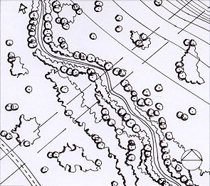
PROCEDURES                                          Development generally requires the consent
                                                    of Council. This consent is sought through
Part 3 of this DCP contains the specific            the lodgement of a development application.
controls applying to Development within the
Hearnes Lake/Sandy Beach area.                      Applicants should follow the step-by-step
                                                    process shown in the procedures flow chart.
Part 4 of this DCP provides more detailed
                                                                PROCEDURES FLOW CHART
controls in relation to subdivision and low-
                                                    Step 1
density residential development. Tourist            Read this DCP and obtain any relevant information sheets
development is to comply with the prevailing
guidelines.                                         Step 2
                                                    Undertake site analysis

                                                    Step 3
                                                    Prepare draft proposal in accordance with the Master Plan (Map
                                                    2) and Planning Controls (Parts 2, 3 and 4)

                                                    Step 4
                                                    Discuss the draft proposals with Council staff and any other
                                                    organisations i.e. DoP*, RTA, DEC, DNR, MPA, LALC

                                                    Step 5
                                                    Check the development meets the general controls in this DCP
                                                    and is consistent with the Master Plan (Map 2)

                                                    Step 6
                                                    Check environmental constraints for:
                                                       Flood prone land
                                                       Significant vegetation
                                                       Acid sulfate soils
                                                       Fire hazard
                                                       Cultural Heritage
                                                       Threatened and/or Endangered Species, Populations,
                                                       Ecological Communities
                                                       Noise

                                                    Step 7
                                                    Consult with adjoining land owners – consider their opinions on
                                                    the proposal

                                                    Step 8
                                                    Consult with Council’s Technical Liaison Committee if appropriate

                                                    Step 9
                                                    Prepare plans/report in accordance with discussions and
                                                    guidance provided
                                    MAP 1
                                 LOCALITY           Step 10
                                                    Lodge development application with Council/Consent Authority

Applicants are also required to comply with                             Where approval granted
the requirements of the Building
                                                    Step 11
Sustainability Index (BASIX) for certain types      Commence work in accordance with the conditions of approval
of development. Liaison with the Department
of Planning is recommended to assist with           * State Environmental Planning Policy (SEPP) No. 71 –
                                                    Coastal Protection applies to land within the DCP Study
development proposals.                              Area. Liaison with the Department of Planning is
                                                    recommended to assist with development proposals.

HEARNES LAKE/SANDY BEACH DEVELOPMENT CONTROL PLAN                                                          PAGE 2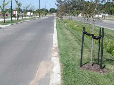
PART 2 – PLANNING STRATEGY: MASTERPLAN
OBJECTIVES                                          Environmental Sustainability

  To provide a framework for a community              Restrict development from environmental
  that is sustainable, safe and vibrant.              protection areas (see Master Plan) and
                                                      require the dedication of such land to
  To provide an overall plan for the area             Council as part of development proposals.
  that enables the integration of existing
                                                      Require developers to provide perimeter
  and proposed development.
                                                      roads adjacent to environmental
                                                      protection areas for fire fighting purposes,
SPECIFIC STRATEGIES                                   access for maintenance, and for passive
                                                      surveillance of parkland by residents.
Economic Sustainability
                                                      Ensure development proposals provide
  Provide for an additional population of             bush fire buffers, which do not encroach
  approximately 1,352 people.                         on environmental protection areas or
  Enable sustainable residential housing and          involve the removal of native vegetation.
  low-key ecotourism opportunities (refer to          Encourage the use of bush fire buffers for
  Map 5 Target Densities).                            passive recreational activities and/or
  Require developers to provide reticulated           community facilities where it does not
  water and sewer to new development by               involve negative impacts on environmental
  extending the existing network (refer to            values.
  Map 3 Servicing Strategy).                          Ensure development demonstrates the
  Require developers to forward fund any              achievement of the Stormwater
  works required ahead of Council’s                   Management Strategy for the release area
  Developer Servicing Plans.                          (see attachment A).
  Provide access to retail and commercial             Utilise innovative Water Sensitive Urban
  services in the townships of Woolgoolga             Design strategies to reduce nutrient
  and Moonee Beach.                                   loading, sedimentation and chemical
                                                      contamination of local waterways.
Social Sustainability                                 Restrict urban development from land
                                                      identified with a significant flood risk.
  Require developers to construct a collector
  road system accordance with the Master              Utilise acoustic design to ensure highway
  Plan.                                               traffic and Industrial noise does not
                                                      exceed acceptable levels within residential
  Require developers to provide pedestrian            areas.
  access in a timely manner, linking
  residential areas to the public open space          Provide landscaped buffers (utilising local
  network.                                            native species) between future residences
                                                      and the highway/industrial land, and
  Ensure that developers provide bus                  where practicable incorporate essential
  shelters so that all residential areas are          service corridors.
  generally within 500m from the nearest
  shelter.                                            To ensure that development does not
                                                      conflict with the intended outcomes for
  Provide a sporting field, which                     ‘Healthy Modified Lakes’ as specified in the
  incorporates a playground and BMX track             Healthy Rivers Commission Final Report on
  (as shown in the Master Plan).                      Coastal Lakes.
  Ensure that developers provide children’s           To ensure that development is consistent
  playgrounds so that all residential areas           with the aims and objectives of State
  are no further than 500m from the nearest           Environmental Planning Policy 71 – Coastal
  facility.                                           Protection.

HEARNES LAKE/SANDY BEACH DEVELOPMENT CONTROL PLAN                                             PAGE 3
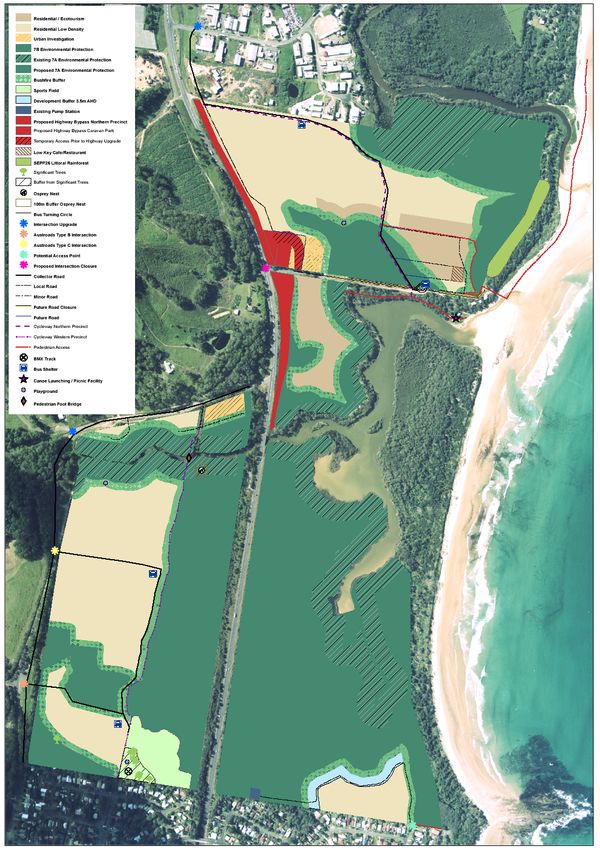
MAP 2
                                                    MASTERPLAN

HEARNES LAKE/SANDY BEACH DEVELOPMENT CONTROL PLAN         PAGE 4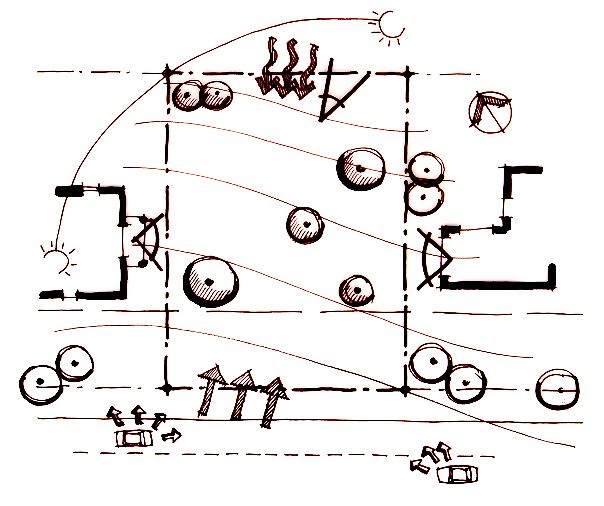
HOUSING STRATEGY                                    SERVICING STRATEGY

  Optimise dwelling yield on areas suitable           Require developers to extend water and
  for urban development;                              sewer from the nearest point identified in
  Ensure densities comply with those                  Council’s Water and Wastewater Developer
  specified on Map 5 – Target Densities;              Servicing Plans (see Map 3);
                                                      Where services identified in Council’s
URBAN DESIGN STRATEGY                                 Water and Wastewater Servicing Plans are
                                                      not in place at the time the developer
  Urban form is to create three precincts as          wishes to proceed, it will be the
  shown on the Master Plan (Map 2);                   developer’s responsibility to forward fund
                                                      these services;
  Each precinct is to provide for compact
  walkable neighbourhoods with access to              Development should enable efficient
  social opportunities and public open space          provision of utility services to new
  areas;                                              localities, and should ensure that
                                                      innovations in Water Sensitive Urban
  A variety of lot sizes and types should be
                                                      Design can be incorporated, either at the
  provided to facilitate housing diversity and
                                                      time of development or in the future.
  choice to meet the requirements of people
  with different housing needs;
  Urban form is to ensure a site-responsive         Northern Precinct
  approach that supports and enhances the
  context in which it is located, particularly        Require developers to provide pump
  the topography and environmental                    stations as shown on Map 3;
  constraints of the land;                            Additional pump stations should be
  Development shall strengthen local                  avoided where other alternatives are
  character and identity and promote a                available.
  sense of community through a range of
  design techniques.                                Eastern Precinct

                                                      Public access is to be provided to the
                                                      existing pump station in the Eastern
                                                      Precinct for maintenance purposes (see
                                                      Map 3).

HEARNES LAKE/SANDY BEACH DEVELOPMENT CONTROL PLAN                                            PAGE 5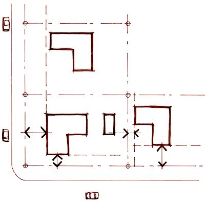
MAP 3
                                                    SERVICES

HEARNES LAKE/SANDY BEACH DEVELOPMENT CONTROL PLAN       PAGE 6
BUSINESS STRATEGY                                   Bosworth Road/Pacific Highway
                                                      Development of the Northern Precinct
  Provide strong links between proposed               being limited to a maximum of 80 lots until
  neighbourhoods and the town centres of              such time as Highway Upgrade works are
  Woolgoolga and Moonee;                              completed or alternative access is
  Provide good accessibility through street           provided via the Pacific Highway
  layouts and promote walking and cycling;            /Bosworth Road Intersection.

  Enable the development of a low-key                 Development of the northern precinct
  Restaurant/Café or General Store in the             above 80 lots being restricted to the
  Northern Precinct.                                  number of lots to be accommodated by
                                                      the Pacific Highway/Bosworth Road
                                                      Intersection in terms of safety and
                                                      intersection capacity, until such time as
COMMUNITY FACILITIES                                  the Pacific Highway Bypass works are
STRATEGY                                              complete.

  Investigate the feasibility of relocating         Graham Drive/Pacific Highway
  and/or improving the existing car parking
  area near the entrance to Hearnes Lake to            Major development ahead of the Pacific
  cater for the increased visitors to the area.       Highway upgrade within the Western
                                                      Precinct is subject to:
  Develop a Plan of Management in
  consultation with the Department of Lands            the upgrade of the Graham Drive/Pacific
  for the foreshore area to enable the                Highway intersections;
  provision of low-key community facilities.           the construction of two new intersections
  Provide adequate transport and pedestrian           off Graham Drive to service the
  linkages to community facilities and open           development (as shown in the Master
  space areas.                                        Plan);
                                                      -   the upgrade of the Morgans Road
                                                          Intersection.
TRAFFIC AND TRANSPORT
                                                    Eastern Precinct
STRATEGY
                                                      It will be the responsibility of the
Hearnes Lake Road                                     developer to undertake a Traffic Impact
  The DCP assumes that the Roads and                  Statement to determine any works
                                                      required to mitigate impacts of the
  Traffic Authority (RTA) will upgrade the
  Hearnes Lake Road/Pacific Highway                   development on the existing local road
  Intersection as part of the Coffs Harbour           network;
  Highway Planning Strategy. Hearnes Lake             The Traffic Impact Statement shall provide
  Road may be closed at the Pacific Highway           emphasis on the following
  as part of this upgrade.                            roads/intersections:
  Investigate the feasibility of closing               - Ti Tree Road
  sections of Hearnes Lake Road to provide             - Maple Road
  for environmental benefit to the lake,               - Chestnut Avenue
  subject to alternative access being
                                                       - Pine Crescent
  provided to residents.
                                                       - Diamond Head Drive
                                                      It will be the responsibility of the
                                                      developer to provide facilities (such as
                                                      cycleways, bus shelters, pedestrian cross
                                                      over points) identified as being necessary
                                                      in the Traffic Impact Statement or
                                                      considered necessary by Council.

HEARNES LAKE/SANDY BEACH DEVELOPMENT CONTROL PLAN                                           PAGE 7
General Exclude urban development from known
Habitat for Wallum Froglet and other
It will be the responsibility of the
endangered fauna species, and provide
developer to provide a collector road
sufficient buffers to development;
system that reduces the reliance on the
Pacific Highway for local trips. Provide bush fire buffers between
environmental protection areas and future
Provide bus shelters as identified in the
development without the need to remove
Master Plan (Map 2) to service the entire
high value native vegetation;
area;
Dedicate land that cannot be developed
Provide a bus turning area on Hearnes
due to the required bush fire buffers to
Lake Road as shown in the Master Plan
Council and incorporate into environmental
(Map 2);
protection areas;
It will be the responsibility of the
Where practicable, enable the use of bush
developer to:
fire buffers for activities ancillary to tourist
- extend local road access to the development;
identified collector road system;
- ensure pedestrian and cycleway Require the dedication of environmental
linkages are provided to the northern protection areas to Council as
beaches cycleway, local schools, development occurs;
shops, playing field, parks and Where practicable, seek to incorporate
beaches; environment protection areas into the
- implement traffic calming devices at Coffs Coast Regional Park;
cycleway crossover points on the
Manage environmental protection areas
collector road system;
not incorporated into the Coffs Coast
- utilise minimum road and verge Regional Park in accordance with the
widths for Hearnes Lake Road to relevant Plan of Management (PoM):
prevent impacts on significant
- Natural Areas PoM;
roadside ecology.
- Coffs Harbour Coastal Reserves PoM;
Manage environmental protection areas in
NATURAL ENVIRONMENT consultation with the Department of Lands
STRATEGY where the land is Crown Land under the
management of Council or Vacant Crown
Protect and enhance environmental Land;
protection areas as identified on the Manage foreshore areas in consultation
Master Plan and Map 4 (includes bush fire with the Marine Parks Authority and
buffers, creek buffers, development ensure that education and/or
buffers, significant vegetation and other interpretation signage is provided for
constrained land); residents and visitors to the area;
Exclude urban development from sensitive Ensure that future development does not
areas to protect riparian vegetation, degrade the environmental values of the
maintain water quality, and provide Solitary Islands Marine Park and that
habitat linkages; future development is consistent with the
Eliminate adverse impacts of development objectives of the Solitary Islands Marine
upon the aesthetic, recreational and Park Zoning Plan for Hearnes Lake:
ecological value of the flood plain; Habitat Protection Zone Objectives
Protect and enhance high value - The protection of biological diversity,
vegetation; habitat, ecological processes, natural
and cultural features; and
Exclude urban development from areas
with a high water table where there is - Opportunities for recreational and
likely to be adverse impacts on commercial activities, scientific
groundwater or surface water quality; research, and educational activities.
HEARNES LAKE/SANDY BEACH DEVELOPMENT CONTROL PLAN PAGE 8OPEN SPACE AND RECREATION STRATEGY Incorporate environmental protection areas into a network of public open space, as shown on Map 4. Establish a sporting field, playground and BMX track with adequate linkages to existing and future residences, open space areas and Sandy Beach Primary School (Map 4). Provide children’s playgrounds within reasonable walking distance (500m) of all future housing (Map 4). Manage open space areas and community land in accordance with the relevant Plan of Management. Encourage passive recreation within open space areas (including bush fire buffers) where it does not involve the removal of native vegetation and/or damage to the environmental values of the area. Investigate the use of 4WD Vehicles on Hearnes Lake Beach and prohibit such use where it is found to be damaging to significant environmental values of the Solitary Islands Marine Parks and/or surrounding environments. Investigate the relocation of the existing car parking area at the entrance to the Lake and the rehabilitation of the area with local native species. HEARNES LAKE/SANDY BEACH DEVELOPMENT CONTROL PLAN PAGE 9
MAP 4
                                                    OPEN SPACE NETWORK

HEARNES LAKE/SANDY BEACH DEVELOPMENT CONTROL PLAN                 PAGE 10
PART 3 - PLANNING CONTROLS
DENSITY URBAN DESIGN
The density of development within each Subdivision layouts should establish legible
precinct is to be in accordance with the street and open space networks, and
target densities specified on Map 5. should generally provide for buildings
fronting streets to ensure safe, attractive
and efficient circulation of pedestrians,
HEIGHT cyclists and drivers.
Development shall connect well to existing
Buildings are not to exceed 6m in height. or proposed development on adjacent
sites.
Note: Height means the distance measured Development shall provide open space
vertically from any point on the eaves/ linkages to adjacent environmental
gutter line of the building to the natural
protection and/or open space areas.
ground level immediately below that point.
A landscape plan is required detailing
treatment of the streetscape utilising local
native species and shall include a three-
HOUSING MIX year maintenance plan. The landscape
plan shall be submitted to Council prior to
General Controls the release of the Subdivision Certificate.
Landscaping requirements shall not be
Development is to comply with the
reliant on Council land and is to occur on
controls provided below and Part 4 of this
public land only at the request of Council.
DCP;
Residential development utilising ‘gated’
Lots must have appropriate area and
street formats is strongly discouraged.
dimensions to enable efficient siting and
construction of a dwelling and ancillary Where retirement or other lifestyle
buildings, provision of private outdoor developments are proposed, these must
space, convenient vehicle access to a incorporate the majority of their
public road and adequate parking. development on public streets, with good
linkages to surrounding areas.
Tourist development should be in
accordance with the prevailing guidelines;
Where practicable bush fire buffers can be
utilised for recreational activities,
TIMING OF DEVELOPMENT
community facilities and stormwater
No development is to occur until adequate
treatment.
road access and reticulated water and
sewerage services are available to the
land.
HEARNES LAKE/SANDY BEACH DEVELOPMENT CONTROL PLAN PAGE 11WATER QUALITY ENERGY EFFICIENT DESIGN
Development involving earthworks or Lots are to be orientated to facilitate the
vegetation removal shall be accompanied siting of dwellings that will have adequate
by an Erosion and Sediment Control Plan solar access.
in accordance with Council's Policy.
A minimum of 75% of lots in any proposed
To ensure protection of water quality, the subdivision for single dwelling allotments,
following buffers are to be provided (as shall be orientated so that the long axis of
determined by Council and shown on the the lot is within the range shown in the
Master Plan): Diagram.
- A minimum of 50m from an RL Level
of 3.5 around Hearnes Lake and
Double Crossing Creek;
- 50m from SEPP26 Littoral Rainforests;
- 50m from SEPP14 Wetlands;
- 50m from Willis Creek,
- 20m from all other creeks,
As part of development proposals the
buffers specified above are to be
rehabilitated and revegetated using local
native species, in accordance with a
detailed plan approved by Council, and
dedicated as environmental protection
land (refer to Master Plan and Map 4);
Development applications for subdivision
are to be accompanied by water quality Residential development shall be designed
modelling to assess the impact of in accordance with Council's Energy
development in accordance with the Efficiency Information Sheet.
Stormwater Strategy for each precinct
(refer to attachments A);
Development is to incorporate Water FLOODPLAIN MANAGEMENT
Sensitive Urban Design in accordance with
Council’s adopted policy. General
Development applications for low lying
areas are to be accompanied by Development will be required to comply with
groundwater monitoring over 12 months Council’s Flood Prone Land Policy, parts of
and an assessment of the impacts of which are summarised below.
proposed development, particularly
placement of fill, drainage and stormwater Subdivision
facilities with regards to groundwater
quality and levels, and the impacts on the All lots within a Flood prone Area (as
estuary. defined by Council) must have a house
site with a minimum area of 400m2, with a
minimum width of 15m, above the 100
year flood level.
Any portion of the lot lower than the 100
year flood level will have a restriction on
the construction of non exempt structures.
HEARNES LAKE/SANDY BEACH DEVELOPMENT CONTROL PLAN PAGE 12Where development involves landform Where Site Assessment Reports, Remedial
modification below the 1% flood level, the Action Plan’s, or Validation Reports are
proposed development shall comply with required as part of development
the following provisions: applications, these are to be prepared in
- A flooding analysis is to be submitted accordance with relevant guidelines
with the development application and prepared by the NSW Environment
approved by Council’s Flooding Protection Authority (EPA) including the
Engineer prior to issue of consent. following:
- No filling will be permitted within the - Guidelines for Assessing Banana
High Flood Risk Precinct. Plantation Sites (EPA 1997) and;
- Minor filling may be permitted within - Guidelines for Consultants Reporting
the 1% flood extent subject to an on Contaminated Sites.
engineers report certifying the The National Environmental Protection
development will not result in any Council’s National Environment Protection
increased flood affectation elsewhere (Assessment of Site Contamination)
and results in a better planning Measure (1999) shall also be considered
solution. Minor filling being regarded as as part of assessment reports.
filling resulting in the 1% flood line
having a more regular shape and/or Where the detailed site assessment
minor movement of the line to facilitate indicates that a Remedial Action Plan
a more practicable and/or efficient (RAP) is required, this Plan shall
development. accompany Development Applications.
- No adverse change to the flood These reports are to be prepared by
behaviour will be permitted, either on suitably qualified and experienced
properties adjoining the site or professionals.
elsewhere including upstream and Where the aggregate area to be
downstream of the site. remediated is more than 3 hectares, the
Local perimeter roads should be above the development becomes designated
1% flood level. development and requires the preparation
Internal road layouts and subdivision of an Environmental Impact Statement.
design shall consider flood evacuation No remediation is to occur without Council
issues for pedestrians and vehicles. approval; compliance with the
Roads across waterways are to be abovementioned guidelines; and
constructed to Council standards. compliance with SEPP 55 – Remediation of
Land.
In designing subdivisions, consideration
must be given to the requirement for
General
dwelling floor levels to be 500mm above
the 1% flood level. Development applications for land being
potentially contaminated and/or previously
used for banana cultivation shall include as
POTENTIALLY CONTAMINATED a minimum, consideration of site history
LAND and the potential of soil contamination
from previous land use.
The following requirements apply to any Where this consideration identifies soil
land with a history of Banana Cultivation contamination and/or cannot exclude the
and/or Potentially Contaminated Land possibility of contaminated land, then a
identified. detailed site assessment shall be
A detailed site assessment report with undertaken as above.
regard to potential soil and groundwater
contamination shall be submitted with
development applications for the above
land.
HEARNES LAKE/SANDY BEACH DEVELOPMENT CONTROL PLAN PAGE 13MAP 5
TARGET DENSITIES
HEARNES LAKE/SANDY BEACH DEVELOPMENT CONTROL PLAN PAGE 14CULTURAL HERITAGE A comprehensive inspection and
assessment of the site area;
Northern Precinct Management options are to be developed
on the basis of an interpretation and
Site HL1 (see Map 6) investigation of the results by a person
deemed suitably qualified by Council.
It will be the responsibility of the developer
to undertake an Archaeological Western and Eastern Precincts
Investigation into Site HL1 identified on
Map 6. General
The investigation is to involve:
An Archaeological Assessment must be
- The removal of grass cover by
undertaken as part of the development
controlled burning to minimise ground
application process.
disturbance;
- A comprehensive inspection and Archaeological Assessments must:
assessment of the site area following - be undertaken by person(s) deemed to
the removal of the grass cover to be suitably qualified by Council and the
determine the need for subsurface local Aboriginal Land Council.
testing, artefact salvage and/or site Note: consultants must have an appropriate
protection; knowledge/attachment to the Hearnes
It will be the responsibility of the developer Lake/Sandy Beach area.
to obtain an appropriate permit from the - Comply with the National Parks and
Department of Environment and Wildlife Act 1974 and Environmental
Conservation before undertaking any Planning and Assessment Act 1979.
subsurface testing and/or artefact salvage; - Consider specific ‘links’, which are
The Archaeological Investigation must be important to the Gumbaingirr Aboriginal
in accordance with the National Parks and community.
Wildlife Act 1974 and Environmental Consultation is to be undertaken with the
Planning and Assessment Act 1979; Local Aboriginal Land Council, Yarrawarra
Aboriginal Corporation & Elders of relevant
Site HL2 – Natural Mythological Site Aboriginal Communities throughout the
preparation of the assessment.
All development is excluded from land
within Site HL2 as shown on Map 6. Cultural Heritage Studies are to be
forwarded to the LALC and YAC for
Adjacent development shall not impact on comments prior to their finalisation.
the spiritual/sacred significance of this site
and an appropriate buffer between the site A copy of the finalised Cultural Heritage
and future development is to be provided. Study is to be given to the LALC and YAC.
The requirements of the National Parks
Spur Crests and Wildlife Act 1974 must be followed if
Lot 21 DP 714858, Lot 1 DP 253878 & cultural/sites places are identified on the
Lot 202 DP 1066412 site and a Section 90 Heritage Impact
Permit obtained from the Department of
It will be the responsibility of the developer Environment and Conservation ahead of
to undertake an Archaeological any site disturbance or destruction.
Investigation to determine the status of
the Spur Crest identified on Map 6 before Lot 22 DP 1070182 – Historic Campsite
any disturbance works commence. (Peron Camp)
The investigation is to involve:
- The removal of grass cover by The Archaeological Assessment must also
manually ‘scrapping off’ (to minimise include an inspection of the former Peron
ground disturbance); campsite.
HEARNES LAKE/SANDY BEACH DEVELOPMENT CONTROL PLAN PAGE 15NATURAL AND HABITAT AREAS - The VMP is to incorporate the treatment
of the highway buffer, using local native
Environmental protection areas are to be species, with an aim to providing a
protected through the provision of buffers scenic buffer for the travelling public;
(see Water Quality) and by excluding - Initial works identified within the VMP
development from flood liable land. are to be completed prior to release of
Land within 100m of any Osprey nest shall Subdivision Certificate;
be added to environmental protection land - Works may be staged but must be
and dedicated to Council as development commensurate with staging of
occurs. subdivision; and
Development applications shall require - Follow up maintenance works identified
assessment of natural and habitat areas. within the VMP are to be costed and
contribution paid to Council at the time
Development or works on land with Known of dedication.
Habitat for Wallum Froglet and other
endangered fauna species will require Protected areas are to be fenced off prior
assessment under the Threatened Species to commencement of works to prevent
Conservation Act 1995. Habitat areas shall degradation of natural vegetation during
be dedicated to Council for environmental construction works.
protection as development occurs.
Development shall have regard to Council’s
Koala Habitat Information Sheet. BUSHFIRE HAZARD
Where practicable, perimeter roads shall All proposals for subdivision must be
be provided adjacent to all environmental accompanied by a Bush Fire Assessment in
protection areas to provide a separation accordance with Council’s Bush Fire
distance between residential development Information Sheet.
and natural areas. Perimeter roads may be
incorporated into bush fire buffers. Bush fire buffers are to be maintained at
all times with minimal fuel loads.
For all environmental protection land
required to be dedicated to Council the Eastern Precinct
following applies:
- A detailed Vegetation Management Plan Beach access is to be provided by the
(VMP) for the rehabilitation/revegetation Developer where identified in the Master
of environmental protection land is to Plan and on Map 4.
be submitted and approved by Council;
- The VMP is to incorporate bush fire
buffers and provide management
measures for the required buffers;
Note: Bush fire buffers can be utilised for
Stormwater Quality Treatment.
HEARNES LAKE/SANDY BEACH DEVELOPMENT CONTROL PLAN PAGE 16MAP 6
CULTURAL HERITAGE
HEARNES LAKE/SANDY BEACH DEVELOPMENT CONTROL PLAN PAGE 17NOISE Roads are to be constructed in accordance
with the standards in the following table:
Applications for subdivision within 300m of
the Pacific Highway and/or land adjoining Collector
Local Minor Road
industrial areas will be required to be Road
accompanied by an acoustic report, Road Reserve
20m 15-16m 13.5-15m
identifying measures (mounding, acoustic Width
barriers, building design, building Carriageway
Width 9-11m 7-8m 5.5-7m
materials, etc) to ensure future residents
are not subject to unacceptable noise Verge 4.5 – 5.5m 2 x 4.0m 2 x 4.0m
levels. Minimum
Design Speed 50km/h 40km/h 25km/h
Assessment is to be undertaken by an
appropriately qualified person, having
4.5 9- 11 4.5 Collector
regard to the following guidelines: NSW
Industrial Noise Policy (EPA 2000) and the 4.0 7-8 4.0 Local
NSW Environmental Criteria for Road
Traffic Noise (EPA 1999). 4.0 5.5-7 4.0 Minor Road
(cul-de-sac)
Western Precinct/Northern Precinct
ROAD DESIGN FOR BUS
Development applications for land shown
ACCESS
as an urban investigation area on the
Master Plan are to submit a detailed
acoustic report (identifying the above Development is to provide for:
measures) and are to be referred to the The safe and efficient movement of buses
Roads and Traffic Authority for comment. through the subdivision.
Staged development which takes into
account bus access.
ROAD DESIGN AND ACCESS
CONTROL Appropriate road widths on roads likely to
form part of a bus route.
Development shall be designed in Bus turning area (Map 7) and bus shelters
accordance with the Traffic and Transport (Map 4).
Strategy.
Linking bus routes and bus stops to the
Development shall be designed to pedestrian network.
incorporate the collector roads shown in
The preservation of significant roadside
the Master Plan (Map 2).
vegetation, particularly along Hearnes Lake
Land required for a local road shall be Road.
dedicated to Council.
Road design and construction works are
to conform to Council’s Development PEDESTRIAN AND CYCLEWAY
Design Specification.
PATHS
Road and footpath treatments are to be
designed throughout the subdivision to The developer is to provide cycleways
create an attractive streetscape. where they pass through the development
Local native street trees are to be planted in accordance with Map 4.
and protected with tree guards and The developer is to provide footpaths in
maintained for a period of three years. accordance with Council’s requirements.
HEARNES LAKE/SANDY BEACH DEVELOPMENT CONTROL PLAN PAGE 18HEARNES LAKE ROAD
Properties affected by the realignment of
Hearnes Lake Road to provide for a bus
turning bay (see Map 7) are to dedicate
the required land as development occurs to
ensure the provision of public access to
beach foreshore areas.
MAP 7
HEARNES LAKE ROAD
HEARNES LAKE/SANDY BEACH DEVELOPMENT CONTROL PLAN PAGE 19PART 4 – GENERAL DEVELOPMENT CONTROLS
RESIDENTIAL LOW DENSITY
OBJECTIVES SITE ANALYSIS
The controls in this DCP seek to: Site analysis is required to identify
opportunities and constraints for building.
encourage innovative housing which is
pleasant to live in, relates to the desired A site analysis plan (at scale 1:200) is to
future neighbourhood character, is include:
responsive to the site and is
environmentally sensitive; and site dimensions (length, width);
improve the quality and choice of housing spot levels or contours;
and residential environments to suit the north point;
diversity of people’s needs and to meet existing site drainage;
community expectations about health, any contaminated soils or filled areas;
safety and amenity. services (easements, utilities);
existing trees (height, spread, species);
SITE ANALYSIS views to and from site;
Cool summer breeze prevailing winds; and
Good surrounding development (where three or
Winter sun path views more dwellings proposed).
N
35m
Significant trees Neighbour’s
Neighbour’s Living Space
Requires Poor overlooks
Living Space
privacy privacy
overlooks
6m setback line
Street trees
Street trees
Major
Cold winter wind Road
Continuous vehicular noise
DESIGN RESPONSE
Retain significant
Provide trees for trees
privacy
Outdoor living to
North
No windows to
avoid overlooking
Living
spaces
6m setback line
Trees will reduce noise
HEARNES LAKE/SANDY BEACH DEVELOPMENT CONTROL PLAN PAGE 20A minimum area of 185m2 is to be
GENERAL SETBACKS
provided for each dwelling for
landscaping.
For dual occupancy development, the
floor area of the proposed dwellings is not
to exceed a floor space ratio of 0.4:1.
Primary Road
The following diagram indicates this.
Area A (2nd storey)
Area B (1st storey)
6m 0.9m
3m 6m
Area C
(allotment) Secondary Road
Buildings are to be setback 20m from
Area A + Area B
must not exceed 0.4 creeks and major watercourses.
Area C
Side and rear setbacks are generally
900mm from walls and 675mm to outer
Note: edge of roof gutter and eaves.
- The floor area is the sum of the areas of
each floor of both dwellings excluding Buildings can be built to side and rear
verandahs, all parking areas, storage boundaries (zero setbacks) where:
sheds and the like. The floor area is to - the building has maximum boundary
be measured from the outer face of the wall height of 3m, unless matching an
external enclosing walls. existing or simultaneously constructed
- The floor space ratio is the floor area of wall;
the proposed dwellings, divided by the - satisfactory legal arrangements for
area of the existing lot.
maintenance of boundary walls are in
place;
For three or more dwellings the frontage - there is no adverse impact upon the
of the property is to be at least 5.5m amenity of the adjoining properties;
wide, so as to provide sufficient area to - there is no interruption to overland
the side of the driveway for services such drainage paths;
as water meter and mail box, as well as - generally, should only occur on
landscaping. For every additional southern boundary;
dwelling over three, the width of the - there are no openings in the boundary
frontage of the property to the street is to wall; and
be increased by 1m (i.e. four dwellings, - the wall is of fire rated masonry
frontage of 6.5m). construction.
Note:
Landscaping is that part of the lot not used ZERO SETBACK
for driveways, car spaces or buildings.
Boundary
No windows or
openings
SETBACKS
3.5m
Buildings are to be generally setback a
minimum of 6m from the front boundary.
On corner lots buildings can be setback
3m from the secondary street boundary.
HEARNES LAKE/SANDY BEACH DEVELOPMENT CONTROL PLAN PAGE 21Make the design of buildings interesting Minimise direct overlooking of living areas
and livable by incorporating some or all of and private open space of other
these elements: dwellings.
- decks;
Building design should provide an
- pergolas;
appropriate scale to the streetscape.
- verandahs;
- eaves; Garages and parking structures are to be
- lattice; and sited and designed so as not to dominate
- climate control windows (i.e. louvres the street frontage.
or small windows, selected glass). Where dual occupancy development is
Use pier or pole construction on slopes in proposed and both dwellings will have
excess of 20%. A maximum of 1m cut or frontage to the street, the dwellings are
fill is allowed outside the buildings not to be mirror reversed.
external walls.
Buildings are to be designed to enhance
the street, by eliminating blank,
featureless walls, which detract from the
appearance of the street.
DESIRABLE DESIGN FOR DUAL OCCUPANCY
Mirror reversing: unacceptable design
solution
Fencing is not to be located along a
boundary adjoining public land unless it is
Garages/parking areas do not
detract from the streetscape
no greater than 1.5m high, and includes
either a setback for landscaping
purposes, or recesses for this same
purpose.
Note:
Council is not bound to enforce S88B
instruments in private matters such as
density and developer preferred building
materials.
SOLAR ACCESS
Buildings should be designed to allow at
least two hours of sunshine upon the
living areas of adjacent dwellings and
open space areas between 9.00 am and
Entry facing the 3.00 pm on 22 June.
Driveway widening street
to front of the Where the possibility of overshadowing
allotment may occur, shadow diagrams are to be
submitted to illustrate the shadows cast
Buildings should allow for some outlook by the proposed building at 9.00am,
to streets, lanes or other public space 12.00 noon and 3.00pm on 22 June.
areas to increase surveillance and thereby
provide for a safer environment.
HEARNES LAKE/SANDY BEACH DEVELOPMENT CONTROL PLAN PAGE 22PRIVATE OPEN SPACE VEHICLE ACCESS AND PARKING
Each dwelling is to have private open Parking
space with direct connection to indoor
living areas through sliding glass doors or Car parking is to be provided behind the
other similar openings. This space should front setback at the following rate:
be oriented to provide for maximum year
round use. Dwelling Type Parking
(Floorspace) Requirement
A minimum of 90m2 is to be provided for per dwelling
each dwelling, preferably provided in one
area. Consideration may be given to the Small dwellings (≤100m2) 1 space
Large dwellings (>100m2) 2 spaces
division of this area into two areas, with
the smallest portion being no less than
Car parking areas should be incorporated
40m2.
into the building or provided at, or
Each open space area is to have a behind, the front setback of the building.
minimum dimension of 4m and a slope
Where more than one space is required
not greater than 1 in 8.
one parking space is allowed between the
Private open space (including swimming dwelling and the front boundary.
pools) is not to be located at the front of
The minimum dimensions of car parking
a development adjoining public road,
spaces should be 2.4m x 5.5m.
unless details of satisfactory fencing are
included with the proposal.
Driveways
N To reduce the impacts of stormwater
runoff, improve visual amenity, and
maintain on-street car parking driveways
should be minimised.
90m2
A driveway, which serves a maximum of
90m2
three dwellings, is to have a minimum
paved width of 2m.
A shared driveway, which serves three or
more dwellings, is to have a minimum
paved width of 4.5m at the street,
continuing at this width to a depth of 6m.
50m2 Long driveways may require ‘passing
points’ (particularly on busy roads).
90m2
40m2 Provision is to be made for vehicles to
enter and leave the site in a forward
direction, where the site is:
- steep;
- fronts a busy road;
- has three or more dwellings on it;
- subject to high pedestrian use; or
- where driveways are more than 30m
in length.
Turning areas are to be designed to allow
the 85% Design Car Turning Path.
Dwellings are not to unreasonably
compromise the private open space of
nearby dwellings.
HEARNES LAKE/SANDY BEACH DEVELOPMENT CONTROL PLAN PAGE 23Driveways should have gradients less For proposals for two or less dwellings
than 20% and the driveway grade should the following is required:
not change by more than 11% for every
- three strips of turf parallel to, and
1.4m of driveway.
against, the kerb;
- coarse gravel to define a single
DRIVEWAYS (3 OR MORE DWELLINGS) construction access no more than 3m
wide;
- install sediment fence:
along the road frontage
2m immediately upslope of the turf
strips or around the low side of the
area of construction if the site
slopes away from the road;
around the low side of stockpiles;
and
with the ends of the fences turned
upslope;
- all stockpiles of topsoil, sand,
aggregate, spoil, vegetation or other
6m
4.5m material capable of being moved by
running water shall be stored clear of
any drainage lines, easements or
natural watercourses, footpath, kerb
Note: or road surface;
For minimum lot frontages and width of
battleaxe handles also refer Council’s - before roofing material is laid,
Subdivision DCP. temporary or permanent guttering
and downpipes shall be installed and
connected to an approved stormwater
DEVELOPER CONTRIBUTIONS disposal system; and
- all disturbed areas shall be rendered
Developer contributions are payable for erosion resistant by revegetation or
any development creating two or more landscaping within four weeks of
dwellings on one lot. building activities being completed or
suspended.
Note:
Developer contributions are a monetary
payment to fund increased demand for
public facilities generated by the
development. 3.5
Re-vegetate
disturbed areas
EROSION AND SEDIMENT CONTROL Topsoil
Silt fence stockpil Turf strip 3m if
For proposals for three or more dwellings sloping towards
an Erosion and Sediment Control Plan is street
required to be submitted to and approved New trees
by Council prior to the release of the
construction certificate; refer “Erosion and 4
Sediment Control on Building and
Development Sites – Policy and Code of Provide coarse gravel
for temporary ROAD
Practice”. construction access
HEARNES LAKE/SANDY BEACH DEVELOPMENT CONTROL PLAN PAGE 24SERVICES Water Meters A separate water meter is to be provided for each dwelling and is to be readily accessible to Council’s meter reader. Stormwater All stormwater is to be directed to the street drainage system, or to an interallotment drainage easement where available. Surface water is not to be directed to neighbouring properties. Stormwater to kerb connections are to be via kerb adapter units. House fencing should not obstruct overland flows of water. House floor levels must be at least 300mm above finished ground level. Note: Interallotment drainage via easements may be required. HEARNES LAKE/SANDY BEACH DEVELOPMENT CONTROL PLAN PAGE 25
SUBDIVISION
OBJECTIVES                                           SITE ANALYSIS
                                                                                                 steep land
The controls in this DCP seek to:

   provide measures to protect and enhance          school
   the natural and built environment by
   ensuring that subdivision patterns relate                                          fauna
   to site conditions;                                                                corridor

   ensure that subdivisions do not detract
   from the desired future neighbourhood
   character of the locality; and                        electricity
                                                         easement
   promote the orderly development of land
   by ensuring that the appropriate form of
   subdivision is used (i.e. Torrens,
   community, strata title) while ensuring
   that it is adequately serviced.

                                                                                                            creek
SITE ANALYSIS

   A site analysis plan is required to identify                                  DESIGN RESPONSE
   opportunities and constraints relating to         pedestrian
   the subdivision pattern and potential end         access to         retain fauna
   use of the land.                                  school            corridor

   A site analysis plan should be prepared                                                              Community lot
   having regard to the following, where                                                                (recreation area)
   relevant:
   -   waterways (creeks, rivers, streams);
   -   significant vegetation/habitat/ fauna
       corridors;
   -   flood liable land;                                                                                Community title
   -   steep land/land slip;                                                                             subdivision
   -   fire hazard;
   -   access points (vehicles, pedestrians,
       cyclists);
   -   soil conditions (acid sulfate,
       contaminated);                                                                                          maintain
   -   surrounding land uses;                            Conventional                                          creek buffer
   -   service connections;                              subdivision                  Fire Protection
   -   easements;                                                                     Zone
   -   archaeological sites;
   -   topography (contours to Australian
       Height Datum at 1m intervals);
   -   aspect;
   -   drainage systems;
   -   existing buildings, driveways, septic
       tanks and disposal areas; and
   -   street and lot layout of locality.

HEARNES LAKE/SANDY BEACH DEVELOPMENT CONTROL PLAN                                                          PAGE 26
DENSITY A subdivision which will involve a lot
having vehicular access to a lane will only
Residential and Tourist Development be permitted after the lot has been
shall comply with the target densities in substantially developed (i.e. vacant lots
maps of this DCP. off laneways are not to be created), and
the lot adjoining the lane is to have 2m
Environmental Protection 7A
wide frontage fenced and paved to the
The minimum lot size is 40 hectares.
primary road, to provide for pedestrian
Environmental Protection 7B access, mailbox, services (water, sewer,
There is no minimum lot size within this electricity, communication).
zone. Lot size is determined having
Where a subdivision will create more than
regard to the merit of the subdivision.
two lots or two dwellings using a common
All lots are to have a minimum 4m driveway, then the form of subdivision is
frontage* to public road**, except: to be either strata or community title. In
- where two ‘battle axe handle’ shaped this situation, the common driveway is to
lots in a (Torrens title) subdivision will be constructed in concrete a minimum of
share a single driveway, then the 4.5m wide at the street, continuing at this
combined widths of the ‘handles’ of width to a depth of 6m, and thereafter of
the lots are to be at least 4m wide, minimum width 2m, prior to the issue of
and each lot is to have room at its the Subdivision Certificate. Adequate
frontage for a water meter and letter room at the frontage to accommodate
box, in addition to accommodating a water meters and letterboxes is also
driveway; required.
- lots which have frontage to a cul-de-
sac head; these lots are to have a
minimum frontage of 10m.
* = strata and community title lots may May only be
achieve such frontage via their common subdivided in
strata or
property. community title
** = not including a lane. fashion
4m
4mwide
wide
handle
handle >10m
frontage road
Subdivisions are not permitted where
three or more ‘battle axe handles’ will
directly adjoin.
Lots fronting a cul-de-sac head
road
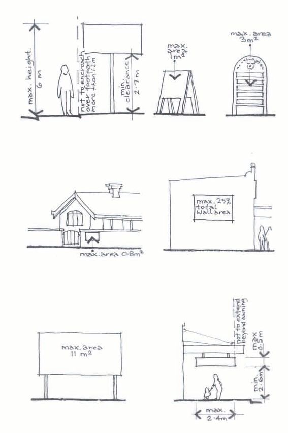
HEARNES LAKE/SANDY BEACH DEVELOPMENT CONTROL PLAN PAGE 27SERVICES Utility Services
General Utility services must be extended to all lots
within a subdivision in accordance with the
Urban Areas following table (except for common property
Subdivisions in urban areas are generally in community title and strata subdivisions):
required to provide infrastructure to all
lots including: Utility Urban Rural Rural
- road; Service Area Residential area
- footpath; Area
- kerb and gutter; Council’s Yes No No
- drainage; water main
Council’s Yes No No
- reticulated sewer and water;
sewer main
- telecommunications;
Telephone Yes* Yes* No
- street lighting; and Electricity Yes* Yes* Yes**
- electricity.
* = In greenfield subdivisions these services
Stormwater Drainage must be underground.
** =Unless the applicant can demonstrate
Stormwater drainage shall be designed and that alternative methods of providing
electricity exists or that the provision of this
provided in accordance with the Precinct
service is cost prohibitive.
Specific Stormwater Strategy (refer to
Attachment A). Conditions on the development consent will
outline how, when and to what standard,
The design details will need to be approved these services are to be provided.
by Council before the drainage is provided,
and will need to be completed to Council’s Street Tree Masterplan
satisfaction prior to the issue of the
Subdivision Certificate. A Street Tree Masterplan will be required for
subdivisions on greenfield sites*. The
Stormwater is to be gravity drained to Masterplan aims to guide street tree planting,
Council’s drainage system. In some providing for a more colourful City which
circumstances inter-allotment drainage complements its natural setting.
easements over downstream properties may
be required. This will necessitate a letter of * = Where public road is proposed, and may
consent from the owner(s) of the downstream be required for community title subdivisions.
properties to be submitted with the
development application. Planting proposed by the Masterplan is to be
determined having regard to:
Drainage from sites should reflect the pre-
existing or natural situation in terms of site and dwelling boundaries;
location, quantity, quality and velocity. location and canopy of existing trees,
noting any trees that overhang the sit;
adjacent streets and trees;
any connection to open space networks or
proposed public reserves;
paving materials and drainage treatment;
details of any existing fencing and walls;
and
location of underground services.
HEARNES LAKE/SANDY BEACH DEVELOPMENT CONTROL PLAN PAGE 28You can also read