Prepared for: City of East Point, Georgia - Prepared by: PATH Foundation and KAIZEN COLLABORATIVE
←
→
Page content transcription
If your browser does not render page correctly, please read the page content below
Prepared by: P
                              ATH Foundatio
                                             n and KAIZEN C
      Prepared for: C                                      OLLABORATIVE
                      ity of East Poin
                                      t, Georgia
Date: October 2
                7, 2016
East Point PATH
City of East Point Trail System Master Plan
        & Implementation Strategy

                         October 27, 2016

           Prepared for the City of East Point, Georgia by:

                 KAIZENCOLLABORATIVE
                 1668 Belle Isle Circle, NE | Atlanta, GA | 30329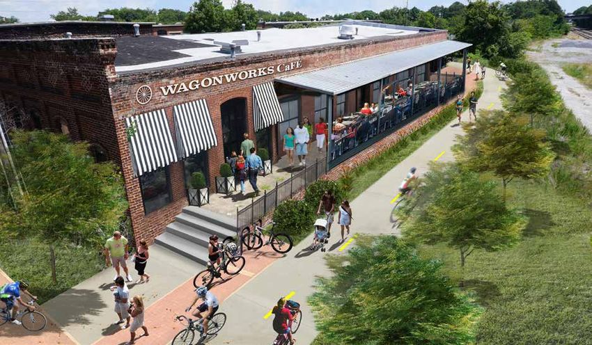
[This Page Intentionally Left Blank]
Table of Contents
Executive Summary

    1 Introduction                                                  1       EP PATH #15 | Camp Creek Greenway                       59-61
                                                                            EP PATH #16 | Georgia Sports Complex to Commerce Park   62-63
    2 Methodology                                                  2-5
                                                                         4 Implementation Strategy                                  64-69
       Planning Process                                              2
       Steering Committee                                            2      Overview                                                   65
       Data Collection and Field Work                                2      Steering Committee Transition                              65
       Establishing Planning Goals                                   3      Creation of Friends Group                                  65
       Trail Facility Types                                        2-3      Implementation Committee                                   65
       Master Plan Development                                       5      Prioritization for Implementation                       66-67
       Public Meeting                                                5      Implementation Timeline                                    68
                                                                            Next Steps                                                 68
    3 East Point PATH Master Plan                                 7-63      Cost Summary                                               69

       EP PATH #01 | Model Mile - Sumner Park to Tri-Cities      11-14
                                                                         5 Branding and Design Standards                            70-83
       EP PATH #02 | Main Street Connector                       15-18
       EP PATH #03 | Wagonworks to Downtown                      19-23
                                                                            Introduction                                               71
       EP PATH #04 | Buggyworks to Tri-Cities High School        24-26
                                                                            East Point PATH Trail System Naming and Logo            71-72
       EP PATH #05 | Tri-Cities High School to Brookdale Park    27-30
                                                                            Trail Signage Standards                                    73
       EP PATH #06 | Sumner Park to Virginia Avenue              31-36
       EP PATH #07 | East Connector                              37-39      Trail Amenities                                         74-76
       EP PATH #08 | Egan Park to East Main Street               40-41      Construction Details and Standards                      77-83
       EP PATH #09 | Downtown to Sumner Park                     42-44
       EP PATH #10 | Sumner Park to Paul D. West Middle School   45-47   Appendix: Steering Committee Members                         84
       EP PATH #11 | Nature Park to Hamilton Holmes Elementary   48-49
       EP PATH #12 | Paul D. West Middle School to Sykes Park    51-52
       EP PATH #13 | Sykes Park to Asa G. Hilliard Elementary    53-55
       EP PATH #14 | Camp Creek Connector                        56-58
Executive Summary
Competition is fierce among Atlanta’s edge cities to lure employers and retain
the younger generation of educated employees. Cities across the metro are
converting from car-centric, bedroom communities to vibrant nodes with the
live-work-play environment that is so attractive to today’s young people. They
are drawn to the density and diversity which pushed people away from the city
decades ago.

The fact that East Point has not been a popular spot for new development
since the great depression provides an opportunity to install transformational
infrastructure near the center of the city before anticipated development takes
place.

This master plan proposes to energize the east side of the tracks across from
downtown by creating a linear park and trail that will spur development and
improve north-south pedestrian and bicycle connectivity through the city.
Utilizing the existing connection over the railroad, the new trail and anticipated
development will certainly boost activity in the commercial area on the west side
of the tracks. This trail segment will become the centerpiece for transforming
East Point into a preferred location for new employers and the educated
millenials they wish to employ.                                                           Trail users throughout the State of Georgia enjoy walking and biking on greenway trails such as this
                                                                                          trail at Panola Mountain State Park.
With the east side of the tracks as a destination of choice, this plan focuses on
connections from schools, neighborhoods, and employment centers to the heart
of the city so all citizens of East Point can access a vibrant, successful city center.
The infrastructure suggested in this plan is designed for the average person who
prefers to walk and bike separated from traffic. The plan also beckons visitors
from airport hotels to walk or bike to restaurants downtown with a trail to
Virginia Avenue.

This plan was crafted with implementation in mind. The city needs to select a
few projects, acquire a few key parcels, and proceed with construction to show
the community that this is a build-it program rather than a plan-it program.
The opportunity for East Point to become a regional destination for employers,
young employees, and visitors is there for the taking.

                                                                                                                                                   East Point PATH Trail System
1 Introduction

                                                                                                                                                                               Introduction
Ribbons of greenspace and trails that weave through neighborhoods,
alleyways, and parklands are a great way to reconnect citizens of cities which
sold their souls to accommodate car travel. Virtually every American city
gave up on human-scale connectivity during the twentieth century and spent
their resources overloading public rights-of-way with infrastructure for
motorized travel.

The PATH/KAIZEN Planning and Design Team suggests it is time to
repurpose some of the public rights-of-way to create safe and enjoyable
spaces for walking, biking, and socializing in East Point, Georgia. The team
has also scoured the city to identify corridors that must be pieced together
and converted into linear parks with trails. The combination of repurposing
some existing public right-of-way and cobbling greenspace corridors
together will give the citizens of East Point a whole new way to move about
the city.
                                                                                 The 200th mile of trail constructed by the PATH Foundation within Georgia in 2014.
The East Point Line will have a positive effect on adjacent property values,
the overall health of the community, and the ability of the city to attract
and retain employers and the educated young people they wish to employ.
Building a system of connected greenways throughout the city will give East
Point a competitive edge over sister cities for decades to come.

The time is now to build the East Point PATH!

                                                                                 The “2013 Silver Comet Trail Economic Impact Analysis and Planning Study” reported $60 mil-
                                                                                 lion dollars annually are spent with the three counties along the greenway trail.

                                                                                                                                                                          1
East Point, Georgia
2 Methodology

              Planning Process
Methodology

              The PATH/KAIZEN Trail Planning and Design Team was summoned by a
              group of individuals interested in pursuing greenway trail development in
              East Point, Georgia. It was agreed the city needed a trail master plan and an
              implementation strategy in order to kickstart the process.

              East Point PATH was developed by having PATH/KAIZEN in the field,
              searching for routes to connect key destinations. Then they reviewed their
              findings with a steering committee organized by the city and community
              leaders. The committee offered guidance, selected the name of the trail system
              and logo, and organized a public meeting to vet the proposed trail system.

              East Point PATH will serve as the blueprint for the City of East Point’s multi-
              use trail development for the next 5+ years with an implementation goal of
              building approximately 9.6 miles of the East Point Path system within the
                                                                                                      Representatives from KAIZEN present the prelimanary master plan and branding ideas to the
              time frame.                                                                             steering committee during the monthly meeting.

              Steering Committee
              PATH/KAIZEN advised the city during the formation of a steering committee,              Data Collection and Field Work
              establishing overall goals for the greenway trail system, approving branding
              and trail standards, and providing local input into trail destinations and routes.      Using the city’s GIS data, assessment of current and future planning and
                                                                                                      development efforts, and feedback from the public, analysis of existing and
              The East Point Path Steering Committee met three times over a three month               proposed trail connections within East Point focused on the following criteria:
              period. The Steering Committee contained representatives from the following
              departments, organizations, businesses and municipalities:                                  •   Is the trail route feasible for construction?
                   • City of East Point                                                                   •   Is the trail route appealing to all users?
                   • Ethic Inc.                                                                           •   Is the trail route perceived as safe?
                   • East Point Citizens                                                                  •   Does the trail route connect desirable destinations?
                   • East Point Housing Authority
                   • East Point Parks & Recreation Advisory Liason                                    Over a four-month period, PATH/KAIZEN conducted field work and analyzed
                   • East Point Velodrome Association, Inc.                                           data to determine if the proposed trail routes were feasible, appealing, safe, and
                      (A list of individual Steering Committee Members is included as the Appendix)

                2                                                                                                                                         East Point PATH Trail System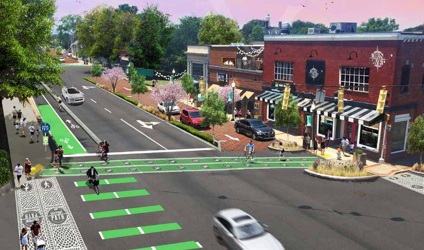
Greenway Trail Typical Section

destination-driven. Once validated by the steering committee, the design team

                                                                                                                                                                              Methodology
recorded and transferred all information onto field maps and into ArcGIS.

Establishing Planning Goals
With many cities and counties jumping onto the ‘bicycling band wagon,’
PATH/KAIZEN began the planning process by establishing goals with the
steering committee for the East Point Path. As a comparison, a Portland,
Oregon study outlining that city’s population into four distinctive types of
cyclists was discussed.

         Four Types of Cyclist - Portland, Oregon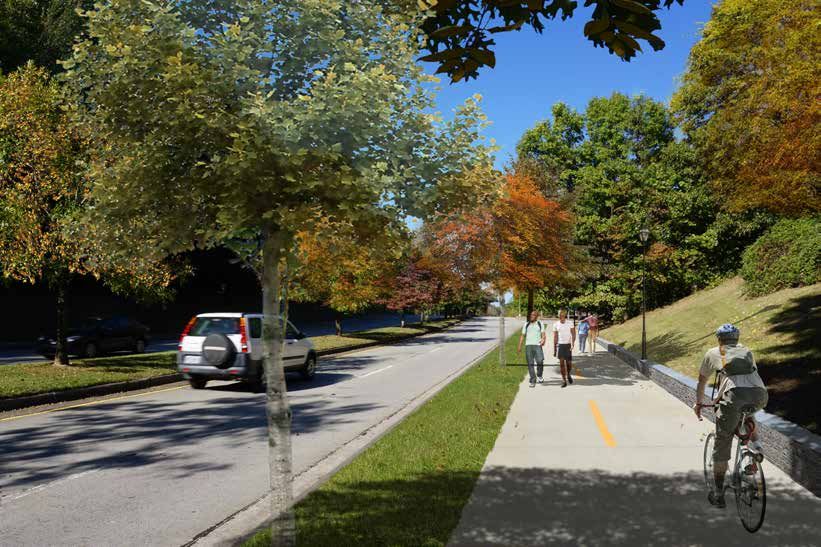
One-Way Cycle Track Typical Section                                                        Two-Way Cycle Track Typical Section
Methodology

                                                                                                     motor traffic by raised medians, on-street parking, or bollards. By separating
                                                                                                     cyclists from motor traffic, cycle tracks can offer a higher level of security than
                                                                                                     bike lanes and are attractive to a wider spectrum of the public.
              Side Paths:                                                                            http://nacto.org/

              Many cities, including East Point, find themselves retrofitting their city with
              trails rather than having them included as part of the infrastructure with new         Neighborhood Greenways:
              development. As a result, shared-use trails alongside roads in existing public
              right-of-way, called side paths, are oftentimes the only option for making the         Neighborhood Greenways are streets with low motorized traffic volumes
              desired connections. Side paths should have a 5 foot landscaped buffer from            and speeds, designated and designed to give bicycle travel priority. Bicycle
              the roadway and markings on the trail to heighten awareness that bicycles and          Boulevards use signs, pavement markings, and speed and volume management
              other users are present.                                                               measures to discourage through trips by motor vehicles and create safe,
                                                                                                     convenient bicycle crossings of busy arterial streets.
              Cycle Tracks:
                                                                                                     Many local streets with low existing speeds and volumes offer the basic
                                                                                                     components of a safe bicycling environment. These streets can be enhanced
              A cycle track is an exclusive bike facility that combines the user experience of
                                                                                                     using a range of design treatments, tailored to existing conditions and desired
              a separated path with the on-street infrastructure of a conventional bike lane.
                                                                                                     outcomes, to create bicycle boulevards. Design treatments are grouped into
              A cycle track is physically separated from motor traffic and distinct from the
                                                                                                     measures that provide the following benefits.
              sidewalk. Cycle tracks have different forms, but all share common elements:
              they provide space that is intended to be exclusively or primarily used for
                                                                                                     Route Planning: Direct access to destinations
              bicycles, and they are separated from motor vehicle travel lanes, parking lanes,
                                                                                                     Signs and Pavement Markings: Easy to find and to follow
              and sidewalks. In situations where on-street parking is allowed, cycle tracks
                                                                                                     Speed Management: Slow motor vehicle speeds
              are located to the curb-side of the parking (in contrast to bike lanes).
                                                                                                     Volume Management: Low or reduced motor vehicle volumes
                                                                                                     Minor Street Crossings: Minimal bicyclist delay
              Cycle tracks may be one-way or two-way, and may be at street level, at sidewalk
                                                                                                     Major Street Crossings: Safe and convenient crossings
              level, or at an intermediate level. If at sidewalk level, a curb or median separates
                                                                                                     Offset Crossings: Clear and safe navigation
              them from motor traffic, while different pavement color/texture separates the
                                                                                                     Green Infrastructure: Enhancing environments
              cycle track from the sidewalk. If at street level, they can be separated from
                                                                                                       * For more information on the types of bike facilities and design guidelines consult the
                                                                                                                NACTO publication Urban Bikeway Design Guide. http://nacto.org/
                4                                                                                                                                        East Point PATH Trail System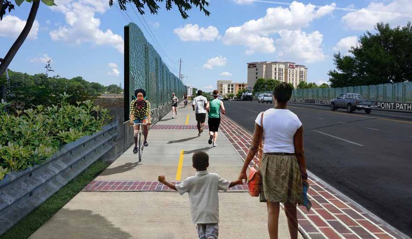
Master Plan Development
The first steering committee meeting for developing The East Point PATH
Master Plan was structured as an introductory kick-off as PATH/KAIZEN
presented their initial fieldwork and preliminary planning for the proposed
trail connections along with the design standards for the trail system.

Through three months of additional field work and collection of the steering
committee’s feedback, PATH/KAIZEN began refining the proposed trail
alignments within the master plan and created the trail system logo along with
trail design standards. The Steering Committee guided and approved the trail
design standards in order to create branding for The East Point PATH trail
system.

After three meetings with the steering committee and two public meetings,
PATH/KAIZEN presented the Steering Committee with a draft of the master          Representatives from PATH/KAIZEN and City of East Point answer questions during the public
plan document including an implementation strategy, timeline, and trail          meeting at Jefferson Recreation Center.
design standards. Feedback and comments were collected and final revisions
were made to The East Point PATH plan. The city presented the document to
the Mayor and City Council on November xx, 2016 for adoption prior to final
printing.

Public Meeting
The PATH Foundation and KAIZEN Collaborative presented the The East
Point PATH Plan during two public meetings coordinated and hosted by
City of East Point on September 13th and 14th, 2016, at the Jefferson Park
Recreation Center and Woodward Middle School. During the meeting, the
design team outlined the benefits of trails and shared the master planning
process for The East Point PATH trail system, then presented the master plan
and design standards. The second half of the meeting focused on gathering
feedback from the community and discussing details of the plan. A vast
majority of the approximately 50 attendees was supportive of the plan.           Attendees at Jefferson Recreation Center for East Point PATH public meeting.
[This Page Intentionally Left Blank]
Overview
              The East Point PATH identifies 24.5 miles of bicycle and pedestrian trail        The following pages present each segment with a brief description and
              connectivity opportunities primarily within the city limits of East Point. The   overview of the existing and planned conditions, opportunities and
              plan achieves the goal of connecting the downtown business district, city        benefits of the proposed plan, potential obstacles, and an estimated cost for
              parks, neighborhoods, major visitor areas and employment centers identified      implementation. The trail segment map shows the proposed trail alignment.
              in the initial planning meetings.                                                The index numbers on each map correspond to vision graphics after the trail
Master Plan

                                                                                               map.
              The East Point PATH trail system has been portioned for ease of
              implementation into 16 trail segments. The names presented for each trail
              segment are working names only. The East Point PATH segments within the
              master plan are:

                    EP PATH #01 | Model Mile - Sumner Park to Tri-Cities           11-14
                    EP PATH #02 | Main Street Connector                            15-18
                    EP PATH #03 | Wagonworks to Downtown                           19-23
                    EP PATH #04 | Buggyworks to Tri-Cities High School             24-26
                    EP PATH #05 | Tri-Cities High School to Brookdale Park         27-30
                    EP PATH #06 | Sumner Park to Virginia Avenue                   31-36
                    EP PATH #07 | East Connector                                   37-39
                    EP PATH #08 | Egan Park to East Main Street                    40-41
                    EP PATH #09 | Downtown to Sumner Park                          42-44
                    EP PATH #10 | Sumner Park to Paul D. West Middle School        45-47
                    EP PATH #11 | Nature Park to Hamilton Holmes Elementary        48-49
                    EP PATH #12 | Paul D. West Middle School to Sykes Park         51-52
                    EP PATH #13 | Sykes Park to Asa G. Hilliard Elementary         53-55
                    EP PATH #14 | Camp Creek Connector                             56-58
                    EP PATH #15 | Camp Creek Greenway                              59-61
                    EP PATH #16 | Georgia Sports Complex to Commerce Park          62-63

                8                                                                                                                          East Point PATH Trail System
East Point PATH Trail Segments Key Map
WOMACK PARK
HAMILTON E. UNITY Knotts Ave
11
HOLMES PARK
Santon Rdt
ELEMENTARY
SCHOOL
St
na n
Connally Dr
New
CONNALLY
NATURE
PARK
Co
2
Headland Dr n na
10
lly
Dr
Dr
PAUL D. BROOKDALE
n
dso
Pegg Rd
WEST MIDDLE
PARK
Dr
Do
igh
SCHOOL Dr
St
kle
St
Wadley ale
Oa
ge
nd
in
Av
Be
TRI-CITIES e
Gle
led
Ma
nH
Wood Hill Lane
Mil
1
HIGH SCHOOL
He
ill
Bryan
Ave
Rd
adl
SUMNER
an
Graywall St
Dr Jefferson Ave
d
4HARRIS 5
Norm Jefferso
Old Colony Rd an Be
CONLEY HILLS PARK
rry Dr n St
ELEMENTARY
Dr
Sylvan Rd
Lexington Ave
12
rk
Wa urn Dr
SCHOOL
Cla
PARK
re Winb
Bayard St
Ave
Riggs Dr
St
Neely Ave
Englewood Rd E Forrest Ave
s
rr i
Ha
Montrose Dr Wa
rre
Master Plan
Montrose Dr n Norma
6
East Point St
Wa nB
t
9
Ware Ave
hS
y err Cleveland Ave East Cleveland Ave
y
urc
Be Dr
South Martin St
n Cle
Ch
Hil
lR ve
lan ATLANTA MEDICAL
3
Kimmeridge Dr
d dA
ve
CENTER
Semmes St
Thom White
pson Way
Ave
EAST
Delowe Dr
Hogan Rd
Ce d
Dorse
y Ave POINT a r Av
e
STATION
Orr Dr
LATIN GRAMMAR Was
h ingt
CHARTER o n Ave
7
Harris St
Sylvan Rd
Washington Ave
SCHOOL
Cent
No Ave
ton
ral Av
rth
sh ing
Fo
rk Wa Holcomb Ave
e
Ca Ben Hill Rd
mp West Taylor Ave
Dr
Cr Meadow La r k Taylor Ave
JOHN D. MILNER
Calhoun Ave
Nor
ee
k CENTER
ATHLETIC
ma
Dogwood Dr
PARK
13
n Berry Dr
COMPLEX
et
Jersey Rd
Stre
t St
SYKES
Delowe Dr
Center Ave t
Plan
Main
Do
S
I-85
rd
So
ut
ds
PARK
Baya
hM
on
d
Maria Head Terrace
Harris Dr
R
art
Dr
in
ton
KE Dr St
LA
ing
St Cen
h
RT
on tral
ec
Dunlap Ave
sh
eR Will Ave
Be
in
WA
Wa
WOODLAND
Dodson Drive Connector
d gham
Dr
CO MIDDLE Vista Ave
Bobby Brown Pkwy
SCHOOL East Vesta Ave
Sir Henry St
8
Myrtle St
Stone Rd Lyle Rd Lyle Ave
Harrison Rd
Bachelor St
Eubanks Ave
ASA G. Mercer Ave Mercer Ave Willin
gh am Dr
HILLIARD West Rugby Ave
ek
Cre
Walker Ave
ELEMENTARY Walker Ave
WOODWARD
mp
BARRETT
Madison St
Walker Ave
I-285
SCHOOL
Ca
Desert Dr
ACADEMY
Prince George St
PARK
rk
W Rugby Ave
et
Fo
14
r St
Conley St
Stre
este
rth
Glouc
St
ic D r
e of
No
Re
Main
Main
dw Duk Cambridge Ave 5
ine I-8
en
Jackson St
East
Pk
Sc
w Ro ad Redwine
y wine Road Rd Hardin Ave
Red ton
shing
Wa
Carriage Way
N Commerce Dr
Virginia Ave Virginia Ave
y
Pkw
s
ke
n La
ceto
Prin
wy
k Pk
ree
pC
15
Cam
Ave
Camp inte gton
Rd
Creek
Pk wy Creek Po Washin HARTSFIELD-JACKSON
ATLANTA INTERNATIONAL
ek
e
Cam
p Cree
Ca mp
Cr
AIRPORT
GEORGIA
Welco
k
Cree
k Pkw
p y
Center Pkwy C am
me All
SPORTS
COMPLEX
Rd
I-285
North Commerce Dr
Campbell
Dr
Ham
BROOKVIEW
marskjold
Dr
Be
nH ELEMENTARY SCHOOL
16
ill R
d
SC
Ridge Rd
om
Somerled Trail
me
rce
Dr
COMMERCE
PARK
I-285
East Point, Georgia 9Master Plan
10
WOMACK PARK
UNITY Knotts Ave
HAMILTON E. PARK
HOLMES
ELEMENTARY
Santon Rdt
St
SCHOOL
an
Connally Dr
wn
Ne
CONNALLY
NATURE
PARK
Co
Headland Dr n na
lly
Dr
r
nD
PAUL D. Pegg Rd
dso
BROOKDALE
Do
WEST MIDDLE Dr
St
r
St
igh D
kle
ge
in
SCHOOL Wadle
y Oa ale PARK
Be
Ave nd
Ma
led
Gle
nH
Wood Hill Lane TRI-CITIES
ill
Mil
He
Rd
Bryan
adl
HIGH Ave
SCHOOL
an
d
Dr Jefferson Ave
Norm
Old Colony Rd SUMNER an Be Jeffers
on St
rry D
r
Graywall St
CONLEY HILLS
Dr
PARK
rk
ELEMENTARY Lexington Ave
rn Dr
Cla
SCHOOL
Wa
re A
HARRIS Winbu
ve
Sylvan Rd
St
Neely Ave PARK
is
Englewood Rd E Forrest Ave
Bayard St
rr
Riggs Dr
Ha
Montrose Dr Wa
Montrose Dr rre
St
n Norma
Wa
y Ware Ave nB
ch
err Cleveland Ave East Cleveland Ave
y
ur
Be Dr
n
Ch
Hi Cle
ve
East Point St
ll R lan
d dA ATLANTA MEDICAL
ve
CENTER
South Martin St
Thom White
pson Way
Ave
Kimmeridge Dr
Semmes St
Hogan Rd EAST
Ce d
Dorsey a r Av
Ave POINT e
Delowe Dr
STATION Was
h
Orr Dr
LATIN GRAMMAR ingt
o n Ave
CHARTER Washington Ave
SCHOOL
Harris St
Centr
No n Ave
gto
Sylvan Rd
rth
shin
al Ave
Fo
rk Wa Holcomb Ave
Ca Ben Hill Rd West Taylor Ave
Dr
mp Calhoun Ave
Meadow La r k Taylor Ave
Nor
Cre
ek CENTER JOHN D. MILNER
ma
PARK ATHLETIC
et
COMPLEX
St
Jersey Rd
t
n Berry Dr
n Stre
t
Dogwood Dr
S
Center Ave
Do
rd
Plan
ds
Mai
So
I-85
SYKES ut
on
Rd
Delowe Dr
Baya
hM Maria Head Terrace
Dr
art
ton
in St
E PARK Dr
h
ing
Harris Dr
AK
ec
sh
L Sto Cen
Dunlap Ave
Be
ne Willi tral
Wa
RT Rd n gha
Ave
WA WOODLAND m Dr
CO MIDDLE Vista Ave
SCHOOL East Vesta Ave
Stone Rd Lyle Rd Lyle Ave
Eubanks Ave
Myrtle St
Sir Henry St
Dodson Drive Connector
Mercer Ave Mercer Ave Willin
g
Bobby Brown Pkwy
ASA G. ham
ek
Dr
Harrison Rd
Bachelor St
Cre
HILLIARD West Rugby Ave Walker Ave
Walker Ave
mp
ELEMENTARY
Ca
BARRETT WOODWARD Walker Ave
rk
I-285
et
SCHOOL W Rugby Ave
Fo
St PARK ACADEMY
ster
Madison St
Stre
St
rth
ce
Desert Dr
Glou
No
e of
ic D r
Re
D uk Cambridge Ave 5
Main
Main
Conley St
dw I-8
en
ine
Sc
Prince George St
ad
East
Pk
w y e Ro
Redwine
d
win Road
nR Hardin Ave
Red to
Jackson St
shing
Wa
Virginia Ave Virginia Ave
y
Pkw
Carriage Way
s
N Commerce Dr
nL ak e
ceto
Prin
wy
k Pk
ree
pC
Cam
Ave
Camp Po inte ng ton Rd
Creek k Washi
Pkw y Cree HARTSFIELD-JACKSON
ek
e
ATLANTA INTERNATIONAL
Cam Cr
p Cree AIRPORT
reek k Pkw Ca mp
pC y
Center Pkwy C am
Welcom
GEORGIA
e Al
SPORTS
l Rd
I-285
COMPLEX
Campbell
North Commerce Dr
Dr
marskjold Ham
BROOKVIEW Dr
Ben
Hil
l Rd
ELEMENTARY SCHOOL
SC
om
Legend
m
Somerled Trail
Ridge Rd
erc
Proposed Trail Alignment
eD
r
COMMERCE
EAST POINT PATH City Limits
I-28
PARK
5
Trail Master Plan City/County Owned
0 0.5 1 Mile
Parks
Schools
Prepared for: Prepared by: Date:
PATH Foundation 100-yr Floodplain
CIty of East Point, October 27,
Georgia and 2016 Existing Bridge
KAIZEN COLLABORATIVE Proposed Bridge ±
East Point PATH Trail SystemEP PATH #1 | Model Mile - Sumner Park to Tri-Cities
Description:
Master Plan
Norman Berry Drive runs through the heart of East Point connecting Ends: Harris Park and Tri-Cities High School at Jefferson Avenue
the highly used Sumner Park, downtown East Point, and the Virginia Distance: 7,124 LF (1.35 miles)
Avenue hotel and restaurant district. This chosen model project
for the East Point PATH meets several of the steering committee’s Opportunities and Benefits:
goals of connecting city parks, downtown, and local schools. With
Headland Drive currently under design for new sidewalks and • Connects to the popular Sumner Park
roadway improvements, it is imperative that the city incorporate the • Improves the streetscape aesthetics along Norman Berry Drive
trail component along Headland for the connection to Paul D. West • Increases safety for pedestrians and safe routes to school
Middle School (pg. 43) to meet this model mile project. This will create • Connects to Tri-Cities High School
a highly visual project that will help to spur on excitement and support • Spur to Main Street will increase foot traffic to downtown
from the community to help implement the rest of this plan.
Potential Obstacles:
This segment begins on the north side of Sumner Park at the
intersection of Headland Drive and Kimmeridge Drive as a 10’ wide • Securing funding for the model mile project
side path, running adjacent to Headland Drive to the east. At Warren • Finding the best connection to Tri-Cities from Norman Berry
Way the trail crosses at the signal to the north side of Norman Berry Drive
Drive, and becomes a 10’ wide side path with a three to five foot wide • Limited width with some topography challenges between Headland
landscape buffer. This segment includes a spur trail along Connally Drive and Velodrome
Drive and ends at Main Street, providing opportunities for future
connection to the proposed cycle tracks along Main Street. This Estimated Cost for Implementation:
segment continues along Norman Berry to Milledge Street where it
EP PATH #1 | Sumner Park to Tri-Cities High School
will turn north and follow Milledge Street to Jefferson Avenue, where it
Planning & Engineering $ 141,465.51
will end at Harris Park and Tri-Cities High School. Construction Cost (2016) $ 1,644,425.20
Contingency @15% $ 282,683.43
Overview: Construction Management $ 98,665.51
Total Cost to Implement $ 2,167,239.66
Connecting Destinations: Sumner Park, Tri-Cities High School Estimated costs based on material and labor pricing from 1st quarter 2016. An
Begins: Norman Berry Drive at the intersection of Kimmeridge and estimated cost for easement and property acquisition is not included but should
Headland Drive be considered prior to beginning implementation.
East Point, Georgia 11CONNALLY
NATURE
PARK Model Mile - Sumner Park to Tri-cities
Co
nna
lly
Dr
Master Plan
L D.
MIDDLE h Dr
leig
St
St
Wadl k
OOL Oa
ge
ey
in
Ave
lled
Ma
Mi
He
Bryan
Ave
adl
an
Dr
d
SUMNER Norm
an Be
HARRIS fferso Je
CONLEY HILLS rr y D n St
ELEMENTARY
PARK 2 r
1 PARK TRI-CITIES
Dr
Lexington Ave
rk
SCHOOL Wa
Cla
re
HIGH SCHOOL
Bayard St
Ave
St
Neely Ave
wood Rd E Forrest Ave
is
rr
Ha
Montrose Dr Wa
trose Dr rre Norma
n
East Point St
Wa nB
St
y Ware Ave err
ch
y Dr
ur
South Martin St
Cle
Ch
ve
lan
Kimmeridge Dr
dA
ve
Semmes St
Thom White
p Way
son A
ve
Delowe Dr
Dorse EAST POINT
y Ave
STATION
ER ER
Harris St
TY
Washington Ave
PR POW
Cent
ve KIPP CHA
nA
gto SCHO
ra
OP
in
A
sh
l Ave
Wa Holcomb Ave
Ben Hill Rd West Taylor Ave
Taylor Ave
JOHN D. MILNER
12 East Point PATH Trail System
ATHLETIC COMPLEX
etIndex
Proposed Trail on Norman Berry Drive
Before
1
Existing conditions on Norman Berry Drive looking west.
After
Master Plan
Proposed 10’ wide side path with landscape buffer along the north side of Norman
Berry Drive looking west. By utilizing the full width of the right of way and
condensing the drive lanes down to 10.5’ in width, this trail facility can be achieved.
East Point, Georgia 13Index
Proposed Trail on Norman Berry Drive to Headland Drive
Before
2
Existing conditions on Norman Berry Drive looking west towards Sumner Park on
After
Headland Drive.
Master Plan
Proposed side path transitions from the north side of Norman Berry Drive to the south
side of Headland Drive utilizing the existing pedestrian signals. The proposed intersection
improvements include customized crosswalks, trail signs, and landscaped islands.
14 East Point PATH Trail SystemEP PATH #2 | Main Street Connector
Description: Opportunities and Benefits:
Master Plan
The Main Street connector is proposed to be a two-way cycle track on • Provides regional connectivity
the east side of the street, within the right-of-way, utilizing a concrete • Allows for multiple access points from surrounding streets
buffer curb to separate the path from vehicular lanes. Downtown East • Establishes future opportunity to connect to downtown East Point
Point has undergone an LCI Master Plan process which proposes a • Connects bike commuter with MARTA and other employment
road diet and implements a portion of this two-way cycle track on the areas
east side of the street. The design team sees this as a strong concept • Requires no acquisition of property
and strongly urges the city to build this cycle track along with the LCI
Main Street project as the first phase of this trail segment. Potential Obstacles:
From downtown, the next phase of this segment will extend the cycle • A multi-jurisdictional effort is required with College Park and
track along Main Street to the north, eventually crossing into the City City of Atlanta to make the regional connectivity desired for this
of Atlanta and connecting into the future BeltLine trail. Looking south segment
of downtown, the design team proposes to extend the two-way cycle
track to Willingham Drive. This leaves future opportunity to connect Estimated Cost for Implementation:
further south into College Park.
EP PATH #2 | Main Street Connector
Planning & Engineering $ 196,684.30
Overview: Construction Cost (2016) $ 2,121,405.00
Contingency @15% $ 366,806.04
Connecting Destinations: Future connetion to Atlanta Beltline and Construction Management $ 127,284.30
College Park Total Cost to Implement $ 2,812,179.64
Begins: Main Street at intersection with Knotts Avenue Estimated costs based on material and labor pricing from 1st quarter 2016. An
Ends: Main Street at intersection with Willingham Drive estimated cost for easement and property acquisition is not included but should
Distance: 12,937 LF (2.45 miles) be considered prior to beginning implementation.
East Point, Georgia 15Main Street Connector (North)
Master Plan
WOMACK
PARK
UNITY
Knotts Ave
PARK
Santon Rdt
St
HILLCREST
an
wn
CEMETERY
Ne
EC
Co
nna
AS
lly
Dr
PH
Pegg Rd
igh
Dr
r
BROOKDALE
St
e D
akl PARK
St
Wadl ale
ge
ey O nd
in
Ave
Gle
lled
Ma
Mi
Bryan
Ave
Jefferson Ave
nd
Dr
ER Norm
an Be
rr y D HARRIS fferso
n St
Je
r
PARK TRI-CITIES
Sylvan Rd
gton Ave
Wa ur n Dr
re
HIGH SCHOOL Winb
Bayard St
Ave
St
y Ave
is
SE C
16 East Point PATH Trail System
rr
Ha
tSt
St
ge
in
Main Street Connector (South)
lled
Ma
Mi
He Bryan
adl
an Ave
Dr Jefferson
d
SUMNER Norm
an Be
rr y D HARRIS son S
Jeffer
t
PARK r
PARK TRI-CITIES
Dr
Master Plan
Lexington Ave
rk
Wa ur n Dr
Cla
re
HIGH SCHOOL Winb
Bayard St
Ave
St
Neely Ave
E Forrest Ave
is
PHASE C
rr
Ha
Montrose Dr Wa
rre Norma
n
East Point St
Wa nB
St
y Ware Ave err Cleveland Ave
ch
y Dr
ur
South Martin St
Cle
Ch
ve
lan
ATLANTA MEDICAL
Kimmeridge Dr
dA
ve CENTER
PARKLANE
Semmes St
Thom White
Way
1 ELEMENTARY
SE A
p son A
ve
SCHOOL
EAST POINT
Ce d
Dorse
y Ave PHA a r Av
STATION Was
e
h ingt
o n Ave
Harris St
Washington Ave Cent
ve KIPP CHARTER
nA
gto SCHOOL
ra
sh in
l Ave
Wa
SE B
Holcomb Ave
West Taylor Ave
Calhoun Ave
PHA
Taylor Ave
JOHN D. MILNER
Nor
CENTER
ma
ATHLETIC COMPLEX
PARK
n Berry Dr
t
e
Stre
St
Center Ave t
t
Plan
Main
S
rd
So
ut
Baya
hM Maria Head Terrace
art
in St
Cen
Dunlap Ave Will t ral A
in gha ve
mD
r
East Point, Georgia 17
n PkwyIndex
Proposed Trail through Downtown East Point
Before
1
Bird’s eye view from the pedestrian bridge looking south showing the existing
After
conditions of Main Street at downtown East Point.
Master Plan
Proposed design suggests a road diet to include a two-way cycle track on eastside of
the street, customized crosswalks, and on-street parking space with landscape buffer
on the west side of the street.
18 East Point PATH Trail SystemEP PATH #3 | Wagon Works to Downtown
Description: Potential Obstacles:
Master Plan
The proposed trail segment from the Wagon Works development to • Requires some acquisition
downtown will provide a critical link between the east and west sides
of East Point. The connection is proposed as a multi-use trail from Estimated Cost for Implementation:
the Wagon Works development to Irene Kidd Pkwy to the south. At
Irene Kidd Pkwy the trail turns west and becomes a side path along EP PATH #3 | Wagon Works to Downtown
Planning & Engineering $ 104,203.92
the north side of the road and continues to the intersection with Main
Construction Cost (2016) $ 1,326,732.00
Street and the future cycle track along the east side of the road. Contingency @15% $ 226,580.98
Construction Management $ 79,603.92
The opportunities for the East Point PATH to cross the railroad are Total Cost to Implement $ 1,737,120.82
limited, which makes this segment critical in the overall connectivity Estimated costs based on material and labor pricing from 1st quarter 2016. An
outlined within the East Point PATH. estimated cost for easement and property acquisition is not included but should
be considered prior to beginning implementation.
Overview:
Connecting Destinations:
Begins: Ware Avenue South side of East Point MARTA station
Ends: South side of East Point MARTA station at Main Street
Distance: 3,174 LF (0.60 miles)
Opportunities and Benefits:
• Provides connectivity between the east and west sides of East Point
• Establishes future opportunity to connect across Norman Berry to
Tri-Cities High School
• Creates better access and increased visibility to the east side
East Point, Georgia 19St
St
ge
in
Wagonworks to Downtown
lled
Ma
Mi
He
Bryan
Ave
adl
an
Dr Jefferson Av
d
SUMNER Norm
an Be
rr y D HARRIS son S
Jeffer
t
PARK r
PARK TRI-CITIES
Dr
Master Plan
Lexington Ave
rk
Wa ur n Dr
Cla
re
HIGH SCHOOL Winb
Bayard St
Ave
St
Neely Ave
E Forrest Ave
is
rr
Ha
Montrose Dr Wa
rre Norma
n
East Point St
Wa nB
St
y Ware Ave err Cleveland Ave
ch
y Dr
ur
South Martin St
Cle
Ch
ve
lan 2 ATLANTA MEDICAL
Kimmeridge Dr
dA
ve CENTER
PARKLANE
Semmes St
Thom White
p son A
Way ELEMENTARY
ve 1 SCHOOL
EAST POINT
Ce d
Dorse a r Av
y Ave
STATION Was
e
h ingt
o n Ave
Harris St
Washington Ave
Cent
ve KIPP CHARTER
nA
gto SCHOOL
ra
sh in
l Ave
Wa Holcomb Ave
West Taylor Ave
Taylor Ave Calhoun Ave
JOHN D. MILNER
Nor
CENTER
ma
ATHLETIC COMPLEX
PARK
n Berry Dr
t
e
Stre
St
Center Ave t
t
Plan
Main
S
rd
So
ut
Baya
hM Maria Head Terrace
art
in St
Cen
Dunlap Ave Will t ral A
in gha ve
mD
r
20 East Point PATH Trail System
n PkwyIndex
Proposed Trail along the Wagonworks Warehouse
Before
1
Existing condition of the Wagon Works warehouse at the east side of the rail line.
After
Master Plan
Proposed trail along the warehouse with landscaping improvements, trail amenities,
and brick paving.
East Point, Georgia 21Index
Proposed Public Pocket Park
Before
2
Existing condition of the vacant greenspace adjacent to the Buggy Works development
After
and the pedestrian bridge to downtown.
Master Plan
Proposed trail going through the greenspace, creating a place for public art,
community activities, and events.
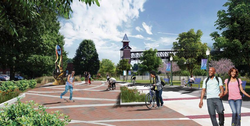
22 East Point PATH Trail SystemIndex
Proposed Public Pocket Park hosting events
Before
2
Existing condition of the vacant greenspace adjacent to the Buggy Works development
After
and the pedestrian bridge to downtown.
Master Plan
The proposed greenspace and the trail can be utilized for hosting events.
East Point, Georgia 23EP PATH #4 | Buggyworks to Tri-Cities High School
Description:
• Provides safe connectivity across Noman Berry Drive
Master Plan
The proposed segment between downtown and Tri-Cities High School • Creates a beautified gateway entrance into downtown East Point
is a critical link in the East Point PATH. It provides a safe, linear • Establishes future connectivity to the northeast neighborhoods of
crossing to the high school while also connecting people to an area East Point
that is poised for redevelopment and economic growth around the • Creates an alternative option of transportation for students
Buggyworks property. commuting to Tri-Cities High School
Beginning at the Buggyworks property, this segment starts at the Potential Obstacles:
existing Pedestrian Bridge to downtown. It begins by going through
the large greenspace adjacent to the current Buggyworks building • Requires some acquisition
and heading north following an abandoned rail spur. In order to be
feasible, some acquisition through this property will be required. Once Estimated Cost for Implementation:
it reaches Norman Berry Drive, a pedestrian bridge is proposed to
span the north side creating a gateway for vehicular travelers entering EP PATH #4 | Buggyworks to Tri-Cities High School
Planning & Engineering $ 81,918.90
downtown East Point, while also making a safe connection to the high
Construction Cost (2016) $ 1,085,315.00
school. The trail will continue north along the Tri-Cities High School Contingency @15% $ 184,852.92
property to Jefferson Avenue. The trail will become a 10-foot side path Construction Management $ 65,118.90
with a 5 foot buffer on the north side of Jefferson Avenue and head east Total Cost to Implement $ 1,417,205.72
to the intersection with Harris Street. Estimated costs based on material and labor pricing from 1st quarter 2016. An
estimated cost for easement and property acquisition is not included but should
be considered prior to beginning implementation.
Overview:
Connecting Destinations:
Begins: Ware Avenue
Ends: Tri-Cities High School on Jefferson Avenue
Distance: 2,920 LF (0.55 miles)
Opportunities and Benefits:
24 East Point PATH Trail SystemBuggyworks to Tri-Cities High School
St
ILLCREST
an
wn
EMETERY
Ne
Master Plan
Co
nna
lly
Dr
Pegg Rd
h Dr BROOKDALE
eig r
St
St Wadl akl a le D PARK
ge
ey O nd
in
Ave
Gle
lled
Ma
Mi
Bryan
Ave
Jefferson Ave
Norm fferso Je
an Be
rr y D
r
HARRIS n St
1 PARK TRI-CITIES
Sylvan Rd
Wa ur n Dr
re
HIGH SCHOOL Winb
Bayard St
Ave
St
E Forrest Ave
is
rr
Ha
Wa
rre Norma
n
East Point St
Wa nB
St
y Ware Ave err Cleveland Ave East Cleveland Ave
ch
y Dr
ur
South Martin St
Cle
Ch
ve
lan
ATLANTA MEDICAL
dA
ve CENTER
PARKLANE
Semmes St
Thom White
p son A
Way ELEMENTARY
ve
SCHOOL
EAST POINT
Ce d
Dorse a r Av
y Ave
STATION e
East Point, Georgia Was 25
h ingt
o n Ave
StIndex
Proposed Pedestrian Bridge to Tri-Cities High School
Before
1
Existing sidewalk on Norman Berry Drive.
After
Master Plan
Proposed pedestrian bridge crossing Norman Berry Drive, connecting east downtown
to Tri-Cities High School. The proposed road diet and side path along Norman Berry
can be seen going below the bridge.
26 East Point PATH Trail SystemEP PATH #5 | Tri-Cities High School to Brookdale Park
Description:
Master Plan
The trail segment connecting Tri-Cities High School to Brookdale • Provides connectivity to the neiborhoods in northeast East Point
Park will provide a critical connection, linking one of the city’s largest • Allows for multiple access points from surrounding streets
and most well-established neighborhoods to one of the larger parks • Establishes a safe connection to Tri-Cities High School
within the city limits. This connection predominantly follows Jefferson • Improves the streetscape aesthetics
Avenue which cuts directly through the middle of the neighborhood,
allowing easy access to the trail for local residents. Potential Obstacles:
This segment begins at the intersection of Harris Street and Jefferson • Requires some acquisition
Avenue. The trail segment begins as a 10’ wide side path with a 5’
wide landscape buffer along the north side of Jeffereson Avenue.
This will require a road diet with minimum 10.5’ lane widths and Estimated Cost for Implementation:
the elimination of parking along the north side of the street. The
side path continues east along Jeffereson Avenue until reaching the EP PATH #5 | Tri-Cities High School to Brookdale Park
block between Constance Street and Sylvan Terrace. Much needed Planning & Engineering $ 87,139.13
greenspace exists behind the properties on the northern part of the Construction Cost (2016) $ 1,135,652.10
street. For a safer and more enjoyable trail experience, the design team Contingency @15% $ 193,639.55
proposes to acquire an easement to utilize this greenspace and connect Construction Management $ 68,139.13
Total Cost to Implement $ 1,484,569.90
to Brookdale on the northeast side of this block. The trail will connect
to an existing pedestrian bridge within the park, leading to an existing Estimated costs based on material and labor pricing from 1st quarter 2016. An
parking area where a proposed trailhead will be located. estimated cost for easement and property acquisition is not included but should
be considered prior to beginning implementation.
Overview:
Connecting Destinations:
Begins: Tri-Cities High School on Jefferson Avenue
Ends: Brookdale Park
Distance: 5,254 LF (1.0 miles)
Opportunities and Benefits:
East Point, Georgia 27Tri-Cities High School to Brookdale Park
St
LLCREST
nan
EMETERY
w
Ne
Master Plan
Co
n na
lly
Dr
Pegg Rd
ig hD
r
r
BROOKDALE
St
kle le D PARK
St
Wadl
Oa a
ge
ey nd
in
Ave
Gle
lled
Ma
Mi
Bryan
Ave
Jefferson Ave
Norm Jeffer
an Be
rr y D
r
HARRIS 1 son St
PARK TRI-CITIES 2
Sylvan Rd
Wa ur n Dr
re
HIGH SCHOOL Winb
Ave Bayard St
St
E Forrest Ave
is
rr
Ha
Wa
rre Norma
n
East Point St
Wa nB
St
y Ware Ave err Cleveland Ave East Cleveland Ave
ch
y Dr
ur
South Martin St
Cle
Ch
ve
lan
ATLANTA MEDICAL
dA
ve CENTER
PARKLANE
Semmes St
Thom White
p son A
Way ELEMENTARY
ve
SCHOOL
EAST POINT
Ce d
Dorse a r Av
y Ave
STATION e
Was
h ingt
28 o n AEast
ve Point PATH Trail System
arris St
n RdIndex
Proposed Trail to Tri-Cities High School
Before
1
Existing condition at the west end of Jefferson Avenue looking to Tri-Cities High
After
School.
Master Plan
Proposed road diet to accomodate the 10’ wide side path and 5’ wide landscape buffer
connecting through Tri-Cities High School with customized crosswalks.
East Point, Georgia 29Index
Proposed Trail on Jefferson Avenue
Before
2
After
Existing condition on Jefferson Avenue looking east.
Master Plan
Proposed 10’ wide side path with a 5’ wide landscape buffer along Jefferson Avenue to
provide strong pedestrian and bicylist connectivity for the adjacent neighborhood.
30 East Point PATH Trail SystemEP PATH #6 | Tri-Cities High School to Virginia Avenue
Description: Potential Obstacles:
Master Plan
This trail segment continues from the east end of the model mile • Limited right of way in some areas
trail on Norman Berry Drive and meets the steering committee’s goal
of connecting downtown, city parks, and the Virginia Avenue hotel Estimated Cost for Implementation:
and restaurant district. The trail is proposed as a side path along the
north side of Norman Berry Drive from Tri-Cities High School to EP PATH #6 | Tri-Cities High School to Virginia Avenue
Planning & Engineering $ 190,330.55
the intersection with Bobby Brown Parkway. The trail will continue
Construction Cost (2016) $ 2,575,509.20
onto Bobby Brown Parkway on the west side to the intersection with Contingency @15% $ 438,055.55
Virginia Avenue. As this is a long corridor, the design team proposes Construction Management $ 154,530.55
that it be implemented in two different phases as seen on the map. Total Cost to Implement $ 3,358,425.85
Estimated costs based on material and labor pricing from 1st quarter 2016. An
Overview: estimated cost for easement and property acquisition is not included but should
be considered prior to beginning implementation.
EP #6:
Connecting Destinations: connection to Hapeville
Begins: Norman Berry Drive at the intersection with Milledge Street
Ends: Bobby Brown Parkway at the intersection with Virginia Avenue
Distance: 11,276LF (2.14 miles)
Opportunities and Benefits:
• Provides connectivity for visitors in the Virginia Avenue hotel and
restaurant district to access downtown East Point
• Allows for multiple access points from surrounding streets
• Improves the streetscape aesthetics along Norman Berry Drive
• Increases safety for pedestrians
East Point, Georgia 31Co
nna
lly
Tri-Cities High School to Virginia Avenue (North) Dr
h Dr BROOKD
leig r
St
le D PAR
St
Wadl k
Oa a
ge
ey nd
in
Ave
Gle
lled
Ma
Master Plan
Mi
He
Bryan
Ave
adl
an
Dr
d
SUMNER Norm
an Be
HARRIS fferso Je
HILLS rr y D n St
NTARY
PARK r
PARK TRI-CITIES
Dr
Lexington Ave
rk
OL Wa ur n Dr
Cla
re
HIGH SCHOOL Winb
Bayard St
Ave
St
Neely Ave
E Forrest Ave
is
rr
Ha
Montrose Dr Wa
rre Norma
n PH
East Point St
Wa nB
St
Ware Ave
y err AS Cleveland Ave
ch
y
ur Dr EA
South Martin St
Cle
Ch
ve
lan
ATLANTA MEDICAL
Kimmeridge Dr
dA
ve CENTER
PARKLANE
Semmes St
Thom White
p son A
Way ELEMENTARY
ve
SCHOOL
Dorse EAST POINT
y Ave
STATION
Was
h ingt
o n Ave
Harris St
Washington Ave
Cent
ve KIPP CHARTER
nA
gto SCHOOL
ra
sh in
l Ave
Wa Holcomb Ave
PHASE B
West Taylor Ave
Taylor Ave Calhoun Ave
JOHN D. MILNER
Nor
CENTER
ma
ATHLETIC COMPLEX
PARK
n Berry Dr
t
e
Stre
St
Center Ave t
t
Plan
Main
S
rd
So
ut
Baya
32 hM East Point PATH Trail System
art
in StHarris St
Tri-Cities High School to Virginia Avenue (South)
Sylvan Rd
Cent
KIPP CHARTER
SCHOOL
ral Ave
Holcomb Ave
PHASE B
West Taylor Ave
Taylor Ave Calhoun Ave
JOHN D. MILNER
Nor
ma
Master Plan
ATHLETIC COMPLEX
n Berry Dr
t
e
Stre
St
Center Ave t
t
Plan
Main
S
rd
So
ut
Baya
hM Maria Head Terrace
art
in St
Cen
Dunlap Ave Will t ral A
ingha ve
mD
r
Vista Ave
Bobby Brown Pkwy
East Vesta Ave
Myrtle St
Lyle Ave
Harrison Rd
Bachelor St
Eubanks Ave
Mercer Ave Mercer Ave Willi
ng ham
Dr
Walker Ave
Walker Ave
Madison St
Walker Ave
Rugby Ave
WOODWARD
et
ACADEMY EGAN PARK
Stre
St
Main
Main
Cambridge Ave 5
I-8
Jackson St
East
Hardin Ave
2
Virginia Ave Virginia Ave
1
East Point, Georgia 33Index
Proposed Trail on Bobby Brown Pkwy Bridge
Before
1
Existing condition on Bobby Brown Pkwy Bridge over I-85.
After
Master Plan
Proposed expansion of the exisitng sidewalk to accomodate a 10’ wide side path with
brick banding and edging. Customized screens are shown on both side of the bridge to
create a more beautified gateway into East Point with trail branding opportunities.
34 East Point PATH Trail SystemIndex
Proposed Trail Branding on Bobby Brown Pkwy Bridge (Daytime)
Before
2
Looking west from I-85 to Bobby Brown Pkwy Bridge.
After
Master Plan
Proposed trail branding opportunity on improved bridge screening
panels.
East Point, Georgia 35Index
Proposed Trail Branding on Bobby Brown Pkwy Bridge (Nighttime)
Before
2
Looking west from I-85 to Bobby Brown Pkwy Bridge.
After
Master Plan
Proposed trail branding night time branding opportunity on improved
bridge screening panels.
36 East Point PATH Trail SystemEP PATH #7 | East Connector
Description: Ends: Spur to River Park
Distance: 7,164 LF (1.36 miles)
Master Plan
The East Connector is proposed to be the link between downtown
East Point and the east side of the city. Starting at the intersection of
Cleveland Avenue and R N Martin Street, this segment travels south Opportunities and Benefits:
along R N Martin Street as a side path on the east side of the road. At
Holcomb Avenue, the side path will make an at-grade crossing to the • Provides connectivity to major local shools and parks
south side of the road and turn east along Holcomb Ave. A spur to the • Allows for multiple access points from surrounding streets
parking area along the northwest corner of the John D. Milner Athletic • Establishes future opportunity to connect to Atlanta Medical
Complex is proposed at this point. Once the side path reaches Bayard Center
Street it will cross into the Sword of the Word Evangelistic church • Will help spur redevelopment of vacant apartment complex
property as a mult-use trail, moving to the northeast and traversing
the parcel owned by the Kipp Fulton Acedemy. The trail continues Potential Obstacles:
east adjacent to the Carver Homes vacant apartment buildings along
Washington Avenue. The trail then makes an at-grade crossing at • Requires some acquisition
Norman Berry Drive and continues into the open green space on the
east side of the road. From here, the multi-use trail moves northeast Estimated Cost for Implementation:
to the Parklane Elementary School property where it will follow along
the creek corridor to the south of the property. This segment will end EP PATH #7 | East Connector
Planning & Engineering $ 113,723.60
at River Park directly across from Parklane Elementary at the existing
Construction Cost (2016) $ 1,182,060.00
parking area.
Contingency @15% $ 205,006.08
Construction Management $ 70,923.60
As an alternative connection if the primary connection is deemed less Total Cost to Implement $ 1,571,713.28
desirable, the side path trail can continue along South Martin Street Estimated costs based on material and labor pricing from 1st quarter 2016. An
until intersects with Norman Berry Drive. It will then merge with the estimated cost for easement and property acquisition is not included but should
proposed Norman Berry Drive side path at this point. be considered prior to beginning implementation.
Overview:
Connecting Destinations: connection to Parklane Elementary School
and River Park
Begins: the intersection with Irene Kidd Parkway and North Martin
Street
East Point, Georgia 37Sylvan Rd
East Connector
Bayard St
is St
rr
Ha
Wa
rre Norma
n
East Point St
Wa nB
St
y Ware Ave err Cleveland Ave East Cleveland Ave
rch
y Dr
u
South Martin St
Cle
Ch
ATLANTA MEDICAL
Master Plan
ve
lan
dA
ve CENTER
PARKLANE
Semmes St
Thom White
p son A
Way ELEMENTARY
ve
SCHOOL
EAST POINT
Ce d
Dorse a r Av
y Ave
STATION e
Was
h ingt
o n Ave
Harris St
KIPP CHARTER
Sylvan Rd
Washington Ave
Cent
SCHOOL
ra
l Ave
Holcomb Ave
st Taylor Ave
Taylor Ave Calhoun Ave
JOHN D. MILNER
Nor
TER
ma
ATHLETIC COMPLEX
RK
n Berry Dr
t e
Alt S o
Stre
St
er
Center Ave t
t
Plan
te
Main
na
S
rd
ut A lign
Baya
hM mn Maria Head Terrace
art
in S
et
t
Cen
Dunlap Ave Will t ral A
in gha ve
mD
r
Vista Ave
Bobby Brown Pkwy
East Vesta Ave
Myrtle St
yle Ave
Harrison Rd
Bachelor St
Eubanks Ave
rcer Ave Mercer Ave Willi
ng ham
Dr
Walker Ave
ker Ave
adison St
38 East Point PATH Trail System
reetMaster Plan Exisitng conditions of the parking lot at the Wagon Works development- Looking South Exisitng conditions of the parking lot at the Wagon Works development- Looking North Existing conditions of John D. Milner Athletic Complex on Martin St City’s standard park signage at River Park East Point, Georgia 39
EP PATH #8 | Egan Park to Main Street
              Description:                                                                 Overview:

                                                                                           Connecting Destinations:
Master Plan

              The Egan Park neighborhood is located at the southern end of the city
              limits and is within walking distance of Woodward Academy and the            Begins: Bobby Brown Parkway at the intersection with Walker Avenue
              restaurant district along Virginia Avenue. This connection will serve        Ends: Intersection with Willingham Drive and Main Street
              as one of the main routes to connect the Virginia Avenue corridor to         Distance: 6,936 LF (1.31 miles)
              downtown East Point. The best opportunity through Egan Park crosses
              city boundary lines into College Park for part of this segment. A multi-     Opportunities and Benefits:
              jurisdictional effort will be necessary to make this portion possible.
                                                                                             • Provides connectivity to Woodward Academy and downtown East
              The connection through Egan Park begins at Walker Avenue, spurring               Point
              from the segment along Bobby Brown Parkway. This segment will be               • Allows for multiple access points from surrounding streets
              a 10’ wide side path on the north side of Walker Avenue to Bachelor            • Creates connectivity to East Point MARTA station and alternative
              Street where it will make an at-grade crossing to Egan Park. Once into           commuting option for kids getting to Woodward Academy
              Egan Park, the trail will meander to the southwest corner of the park          • Requires some acquisition
              where it will enter a city easement and travel onto a neighborhood
              alleyway called West Rugby Avenue. The alleyway should be resurfaced         Potential Obstacles:
              with asphalt and marked with a sharrows labeled for the EP PATH.
              Once the trail reaches Harrison Road, it will make an at-grade crossing        • Requires acquisition of properties north of Walker Ave
              to the north side of West Rugby Avenue. At this point the trail will           • Limited width along Myrtle Street may be challenging and warrant
              transition to a 10’ wide side path with a 5’ wide landscape buffer. The          narrowing the trail
              trail will follow West Rugby Ave until it intersects with Walker Avenue.
              The trail will make an at-grade crossing to the north side of Walker         Estimated Cost for Implementation:
              Avenue and enter the acquired properties as a multi-use greenway tral.
              At the intersection with Mercer Ave, the trail will turn west as a 10’       EP PATH #8 | Egan Park to East Main Street
                                                                                           Planning & Engineering                                           $    98,885.71
              wide side path with a 3’ to 5’ wide landscape buffer to the intersection
                                                                                           Construction Cost (2016)                                         $ 1,214,761.90
              with Myrtle Street. At this point the trail will turn North along the west   Contingency @15%                                                 $   207,980.00
              side of Myrtle Street and continue as a side path until it reaches the       Construction Management                                          $    72,885.71
              South Fulton Community Family track, where it will again become a                                                     Total Cost to Implement $ 1,594,513.33
              10’ multi-use trail. Once at Willingham Drive the trail will turn left on    Estimated costs based on material and labor pricing from 1st quarter 2016. An
              the south side and connect to the Main Street trail segment.                 estimated cost for easement and property acquisition is not included but should
                                                                                           be considered prior to beginning implementation.

               40                                                                                                                       East Point PATH Trail System
Harris St
Egan Park to Main Street
Sylvan Rd
Cent
KIPP CHARTER
SCHOOL
ral Ave
Holcomb Ave
West Taylor Ave
Taylor Ave Calhoun Ave
JOHN D. MILNER
Nor
ma
Master Plan
ATHLETIC COMPLEX
n Berry Dr
t
e
Stre
St
Center Ave t
t
Plan
Main
S
rd
So
ut
Baya
hM Maria Head Terrace
art
in St
Cen
Dunlap Ave Will t ral A
ingha ve
mD
r
Vista Ave
Bobby Brown Pkwy
East Vesta Ave
Myrtle St
Lyle Ave
Harrison Rd
Bachelor St
Eubanks Ave
Mercer Ave Mercer Ave Willi
ng ham
Dr
Walker Ave
Walker Ave
Madison St
Walker Ave
Rugby Ave
WOODWARD
et
ACADEMY EGAN PARK
Stre
St
Main
Main
Cambridge Ave 5
I-8
Jackson St
East
Hardin Ave
Virginia Ave Virginia Ave
East Point, Georgia 41EP PATH #9 | Downtown to Sumner Park
Description: • Allows for multiple access points from surrounding streets
• Connects east side residents to downtown
Master Plan
This segment begins in Sumner Park at the intersection of Headland
Drive and Warren Way as a 10’ multi-use trail spurring off of the Potential Obstacles:
proposed “model mile” along Norman Berry. The trail will travel south
away from the roadway and through the park, utilizing the existing • Requires acquisition of properties
pedestrian bridge. The trail will make its way to the southwest corner
of the park at the intersection of Neely and Lexington Avenue. The Estimated Cost for Implementation:
multi-use trail makes an at-grade crossing to the south, connecting
EP PATH #9 | Downtown to Sumner Park
through a city-owned alleyway to the next block.
Planning & Engineering $ 94,305.96
Construction Cost (2016) $ 1,041,766.00
At Montrose Drive, the trail segment becomes a 10’ wide side path Contingency @15% $ 179,786.69
on the north side, heading east to Semmes St. An at-grade crossing Construction Management $ 62,505.96
is proposed across Semmes Street into a privately owned green space Total Cost to Implement $ 1,378,364.61
proposed for a tiny house development. An easement will be needed Estimated costs based on material and labor pricing from 1st quarter 2016. An
for the multi-use trail to pass through on the north side of this estimated cost for easement and property acquisition is not included but should
property heading east, where it will do an at-grade crossing to the be considered prior to beginning implementation.
south side of West Cleveland Avenue. The trail will be a 10’ wide side
path along Cleveland until it meets Main Street where it connects to
the proposed Main Street segment.
Overview:
Connecting Destinations:
Begins: intersection with Cleveland Avenue and Main Street
Ends: Sumner Park at Headland Drive
Distance: 4,730 LF (0.9 miles)
Opportunities and Benefits:
• Provides connectivity within Sumner Park
42 East Point PATH Trail SystemCONNALLY
Downtown to Sumner Park
NATURE
PARK
Co
nna
lly
Dr
Master Plan
AUL D.
T MIDDLE hD
r
eig
St
akl
St
Wadl
HOOL
ge
ey O
in
Ave
lled
Ma
Mi
He
Bryan
Ave
adl
an
Dr
d
SUMNER Norm
an Be
HARRIS fferso Je
CONLEY HILLS rr y D n St
ELEMENTARY
PARK r
PARK TRI-CITIES
Dr
Lexington Ave
rk
SCHOOL Wa
Cla
re
HIGH SCHOOL
Bayard St
Ave
St
Neely Ave
nglewood Rd E Forrest Ave
is
rr
Ha
Montrose Dr Wa
Montrose Dr rre Norma
n
East Point St
Wa nB
St
y Ware Ave err
ch
y Dr
ur
South Martin St
Cle
Ch
ve
lan
Kimmeridge Dr
dA
ve
1
Semmes St
Thom White
p Way
son A
ve
Delowe Dr
Dorse EAST POINT
y Ave
STATION
ER ER
Harris St
TY
Washington Ave
PR POW
Cent
ve KIPP CH
tonA
SCHO
ra
OP
ing
GA
sh
l Ave
Wa Holcomb Ave
Ben Hill Rd West Taylor Ave
Taylor Ave
JOHN D. MILNER
East Point, Georgia 43
ATHLETIC COMPLEX
etYou can also read