Road Management Plan 2018 - Management System to Inspect, Maintain and Repair Public Roads. Standards of Performance for Road Management ...
←
→
Page content transcription
If your browser does not render page correctly, please read the page content below
Road Management Plan
2018
___
Management System to Inspect, Maintain and Repair Public Roads.
Standards of Performance for Road Management Functions.

Version 4
Adopted by Council: 22 May 2018
Date of Effect: 08 June 2018

                                                                  A8138262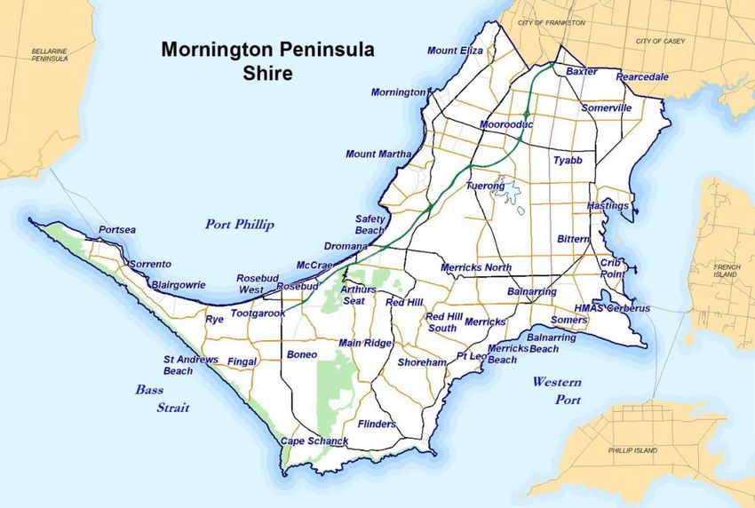
Road Management Plan

APPROVAL
 VERSION                 COUNCIL                                GOVERNMENT                         GAZETTE
     No.            MEETING DATE                      No.              ISSUE DATE                         PAGE No.
       1            6 December 2004                  G51           16 December 2004                           3384
       2           12 September 2011                 G49            8 December 2011                           2874
       3             29 August 2016                  G36           8 September 2016                           2190
       4               22 May 2018                   G23                7 June 2018                           1241

AMENDMENTS incorporated in version 4
 VERSION
                     SECTION                                             DESCRIPTION
   No.
                                        References to Council Plan, RMP standards supersede any other conflicting
       4                   1
                                        standards
                           2            Detail consistent with Shire Council Plan 2017-2021
                          3.2           Dimensions updated
                          3.4           Council Units & External Organisational name updates
                          3.5           Council considers budget and constraints when allocating resources towards the Plan
                          3.6           Detail consistent with Shire Council Plan 2017-2021
                           4            Heading update
                          4.2           Amend to account for updated Road Safety Act version 174 – 1 Jan 2017.
                          4.3           Addition of reference to Section 83 of Wrongs Act
                                        Remove reference to parking provisions in 8A and 8B road hierarchies. Reference to
                         5.1.1
                                        ARRB Road Classifications Report
                         5.1.2          Reference to Shire Off-Street Car Park Specification Revision Report
                         5.1.3          Reference to Shire Footpath Hierarchy Review Report
                                        Clarification of process. Compliance with Sect 19(5) RMA Availability of Register of
                          5.2
                                        Public Roads and Policy
                          6.12          Reference to Shire Roadsides Fire Management Plan
                         7.3.1          Decisions made by Council give consideration to risk and safety
                         7.3.3          Removal of item referring to Open Drains Clearing Schedule
                                        Reference of process for referring private vegetation overhanging footpath envelope to
                         7.3.4
                                        property owner for resolution
                          7.5           Clarification of process and reference to Wrongs Act
                           8            Reference to Council audits of service provider and their data management systems
                           9            Inclusion of provisions ensuring compliance with RMP and audit process of the same
                          11            Legal clarification
                      Appendix 1        Clarification of inspection frequencies of culverts, pipes and drainage structures
                      Appendix 1        Changes to standards for vegetation defect inspections
                      Appendix 1        Changes to standards for signage and street furniture defect inspections
                      Appendix 2        Changes to standards for roadside vegetation response times
                      Appendix 4        Reference to responsibilities for local roads in immediate vicinity of Peninsula Link

Notes:
Excludes minor and editorial changes.

Date of Effect of Amendments: 08 June 2018 (day after date of publication of notice in Victoria Government Gazette.)

                                                      Page 2 of 52                                                      A7678987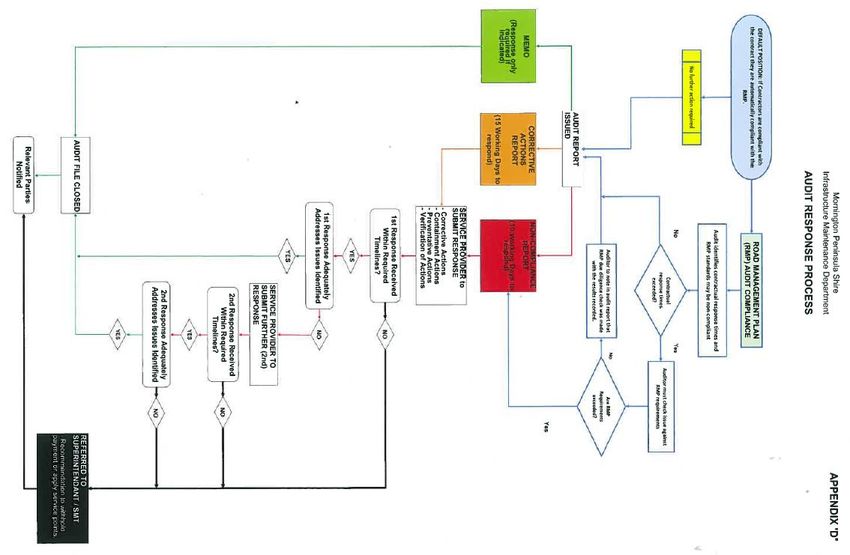
Road Management Plan

Table of Contents:

1.     Purpose and Scope ...................................................................................................... 5
2.     About the Mornington Peninsula ................................................................................... 6
3.     Road Facts ................................................................................................................... 7
       3.1.    Purpose of Asset:................................................................................................................. 7
       3.2.    Description: .......................................................................................................................... 7
       3.3.    Works: .................................................................................................................................. 8
       3.4.    Stakeholders: ....................................................................................................................... 9
       3.5.    Funding: ............................................................................................................................. 10
       3.6.    Relevance of Plan to Shire Council Plan: .......................................................................... 11
4.     Legislative Control and Framework ............................................................................. 12
       4.1.    Road Management Act: ..................................................................................................... 12
       4.2.    Road Safety Act: ................................................................................................................ 12
       4.3.    Wrongs Act: ....................................................................................................................... 13
5.     Assets to which this Plan Applies ................................................................................ 14
       5.1.    Classification: ..................................................................................................................... 15
       5.2.    Register of Public Roads: .................................................................................................. 20
6.     Demarcation ............................................................................................................... 22
       6.1.    State Roads: ...................................................................................................................... 22
       6.2.    Boundary Roads: ............................................................................................................... 22
       6.3.    Intersecting Municipal Roads with Different Classifications: ............................................. 22
       6.4.    Public Transport: ................................................................................................................ 23
       6.5.    Bridges: .............................................................................................................................. 23
       6.6.    Street Lighting: ................................................................................................................... 24
       6.7.    Utilities: .............................................................................................................................. 24
       6.8.    Vehicle Crossings: ............................................................................................................. 24
       6.9.    Pathways: .......................................................................................................................... 25
       6.10.   Pedestrians on Roadways: ................................................................................................ 25
       6.11.   Equestrian Trails: ............................................................................................................... 25
       6.12.   Fire Access Tracks: ........................................................................................................... 25
       6.13.   Roadsides: ......................................................................................................................... 25
7.     Levels of Service ........................................................................................................ 26
       7.1.    Specifications and Standards: ........................................................................................... 26
       7.2.    Inspection and Maintenance: ............................................................................................. 26
       7.3.    Standards of Maintenance and Repair: ............................................................................. 27
       7.4.    Reseal and Rehabilitation: ................................................................................................. 29
       7.5.    Events Beyond Control of Council: .................................................................................... 29
8.     Data Management System ......................................................................................... 30
9.     Auditing Compliance with the Road Management Plan ............................................... 32
10.    Plan Improvement and Monitoring .............................................................................. 33
11.    Glossary ..................................................................................................................... 34
12.    Appendices ................................................................................................................. 36
Appendix 1 – Standards for Inspection ............................................................................... 37
Appendix 2 – Standards for Maintenance and Repair ......................................................... 40
Appendix 3 – List of High Profile Open Spaces ................................................................... 48
Appendix 4 – VicRoads & Peninsula Link (Southern Way Maintained) Roads .................... 50

                                                               Page 3 of 52                                                                    A7678987
Road Management Plan

Page 4 of 52                 A7678987
Road Management Plan

1. Purpose and Scope
In accordance with Division 5 of the Road Management Act 2004 the Mornington Peninsula
Shire, as a road authority, has developed and published this Road Management Plan.

The Road Management Plan (referred to hereafter as the ‘Plan’) for Mornington Peninsula
Shire roads and associated infrastructure assets and is a communication tool used to
document current levels of service and management practices. The plan provides a
transparent and a network wide approach to managing the roads.

This plan will be implemented to fulfil the Shire Council Plan objectives in regard to
infrastructure assets and is in line with the Asset Management Policy and Strategy.

This plan will enable the Shire to fully comply with the requirements of the Road
Management Act 2004, (referred to hereafter as the ‘Act’). The primary objective of the Act
closely aligns with the Shire’s Asset Management Policy objective to facilitate the sustainable
management of the Shire’s infrastructure assets to support the delivery of services to a level
determined by Council.

Section 4 of the Act states its objectives as:

      “The primary object of this Act is to establish a coordinated management
      system that will promote safe and efficient road networks at State and local
      levels and the responsible use of road reserves for other legitimate
      purposes”. 1

The three main requirements to which the Shire needs to comply are the establishment of:

      1.    A Register of Public Roads

      2.    Levels of Service/Standards

      3.    A Management System

This document is and remains a stand-alone and all-encompassing policy document of the
MPSC (for the inspection, repair and maintenance of public roads, paths and road
infrastructure within the municipality of the MPSC) without recourse to any other policy,
practice, procedure, act, matter or thing done (or purported to be done) by or on behalf of the
Council in relation to the performance of the Council’s public road, path and road
infrastructure management functions.

To the extent any other policy, practice, procedure, act, matter or thing done (or purported to
be done) by or on behalf of the Council in relation to the performance of the Council’s public
road, path and road infrastructure management functions adopts (or purports to adopt) a
standard which is in conflict, or inconsistent, with the standards specified by the existing
RMP (other standards), the standards specified by the existing RMP are to prevail over the
other standards, and the other standards have no force or effect.

                                          Page 5 of 52                                   A7678987
Road Management Plan
2. About the Mornington Peninsula
Our Community
Our Place
• Approximately 720 square kilometres of land. The coastline extends over 190 kilometres
and represents approximately 10% of Victoria’s total coastline.
• Approximately 70% of the Shire land is retained as rural land within the Green Wedge
planning zone; 30% is taken up by towns and villages. Approximately 10.5% of the Shire
is public open space.
• Recognised for outstanding biological diversity; significant, rare native plants and
vegetation; wetlands; sites of geomorphological significance; remnant indigenous
vegetation; highly scenic landscape values; and sites of historic importance
• 44 towns and villages are spread across the peninsula: The majority of the residential
population live along the coastline
• Many beach holiday houses are based along the Port Phillip coastline, with the population
swelling by up to 30% in the summer months.
Our Connectivity
• 1.8 cars are parked at the average occupied dwelling
• Over the period 2011-2015, 36 lives were lost and 562 people incurred serious injury
through accidents on Mornington Peninsula roads
• 26.7% of our community experience transport limitations; 3% use public transport to get
to work whilst only 3% use cycling as a mode of transport
• 30.9% use walking as a mode of transport
Our Prosperity
• We have a growing and diverse $11.3 billion local economy that includes retail,
manufacturing, construction and business services
• 13,800 businesses are in the Shire, employing 48,000 people, with 91% employing fewer
than five people
• 95.4% of the labour force (aged over 15 years) is employed and 4.6% is unemployed
• 44.9% of residents hold educational qualifications; 15% hold a Bachelor degree or higher;
21% vocational training and 43.4% hold no formal qualification
• The Peninsula is a premier holiday and retirement destination, tourism is a significant
contributor to the local economy (comprising approximately 11% of Gross Regional
Product)
• The region also has a distinguished agricultural history, including dairy, viticulture
(grapes) and horticulture (fruit, vegetables and flowers), with the existing food and wine
producers being recognised as world class and industry leaders in their respective fields.
Our Wellbeing
• There are 83,623 dwellings with an average household size of 2.42.
• Median weekly household income in the Shire is $1,054
• 50.5% of residents engage in at least one citizen engagement activity per year: 18.6%
perform voluntary work
• The Mornington Peninsula Shire has an active community of retirees with opportunities
for ‘active ageing’ through volunteering, community courses, fine art and discussion
groups, choirs, theatre groups, men’s and women’s sheds
• 62.4% of residents participate in at least one artistic and cultural activity per month. The
Shire has an active arts community.
Our community:
• Population of 155,105 at 2015, with 48.2% male and 51.6% female. The Mornington
Peninsula Shire population forecast for 2017 is 159,710, and is forecast to grow to
178,146 by 2036.
• Between 2011 and 2026, the age structure forecasts for Mornington Peninsula Shire
indicate an 8.2% increase in population under working age, a 38.3% increase in
population of retirement age, and a 6.0% increase in population of working age.
Page 6 of 52 A7678987Road Management Plan
• The Shire has 1,242 Aboriginal residents, with more than half of this population aged less
than 30 years.
• 38,000 residents have some form of disability, with 6,921 requiring assistance with daily
activities. The majority of these people are aged over 65 years.
3. Road Facts
3.1. Purpose of Asset:
The network of roads is provided primarily for travel and transport and the road reserves are
available for other appropriate uses. 1 This might include for example provision for nature
strips, remnant vegetation, native animal corridors, and utilities.
3.2. Description:
The Shire’s municipal road network has approximately 3,800 separate roadways with a total
length of approximately 1,700 km. This is made up of:
• 1,364 km of local roads with a sealed surface
• 336 km of local roads with an unsealed or unformed surface
These road lengths do not include the freeways and arterial roads controlled and maintained
by VicRoads or Southern Way.
1
Road Management Act 2004, s. 20(1).
Page 7 of 52 A7678987Road Management Plan
The roads indicated in green and black are Freeways and Arterial Roads that are managed
by VicRoads. Peninsula Link Freeway is managed by Southern Way. The major municipal
roads managed by the Shire are shown in brown.
In addition to the above length of roads, the following road assets form a significant
component of the road network that the Shire has responsibility for:
• Kerbs approx. 2,000 km
• Shoulders: approx. 375 km
• Roundabouts: approx. 160 No.
• Medians: approx. 1,400 No.
• Pathways: approx. 650 km
• Car parks: approx. 530 No.
• Road bridges: 6 No.
• Major culverts: approx. 32 No.
• Drainage Pits: approx. 50,000 No.
• Drainage Pipes: approx. 1,320 km
(For dimensions refer Shire Doc. Ref A7591889)
3.3. Works:
• The maintenance of bitumen surface pavements and shoulders requires attention
by service providers to repair corrugations, potholes, depressions and scouring.
Intervention levels have been specified for road failures and, when repaired, must
comply with Shire standards.
• Maintenance for unsealed pavements and shoulders is as above plus road and
shoulder grading and dust suppression.
• Service providers carry out regular inspections to identify failures that need to be
repaired as well as responding to failures that have been identified by concerned
members of the community.
• The service provider also provides a street sweeping program and maintenance
of drainage systems to ensure that the road operates effectively and to help
maximise the useful life of the pavement.
• A percentage of the road network is resealed and rehabilitated annually in order
to achieve across the network the specified pavement performance outcomes of
the Safer Local Roads contract. In order to identify and prioritise roads for
treatment, a three-yearly cycle of independent road pavement inspections is
undertaken. The resultant data is modelled through the service providers
Pavement Management System in order to determine the annual works program.
This program is subject to approval and sign-off by appropriate Shire
representatives prior to commencement of annual works. If the required
performance outcomes are not achieved and verified by subsequent condition
assessments, an approved rectification program of works are undertaken to bring
the network back to the specified standard.
• Agreements for works have been established for:
• Municipal boundary roads between the Shire and the two abutting
municipalities, Frankston City and the City of Casey.
• Operational works maintenance (VicRoads)
• Bus stops (Department of Transport, Planning and Local Infrastructure /
Public Transport Victoria)
• Railway level crossings [Safety Interface Agreements] (VicTrack)
• Assets adjoining Peninsula Link Freeway (Southern Way)
Page 8 of 52 A7678987Road Management Plan
• Utilities will also do works on their own infrastructure which can involve Shire
assets, such as having to dig up a section of road. The utilities are required to
comply with the Road Management Act Code of Practice for Management of
Infrastructure in Road Reserves.
• New roads and other assets that are constructed by developers as part of new
subdivisions do not become the responsibility of Council until assessed by Shire
Officers as meeting required standards.
3.4. Stakeholders:
A stakeholder is any person or group having an interest in the service provided by the asset.
The following key stakeholders have been identified:
• Mornington Peninsula Shire • State Road Authorities
Council • Abutting municipalities
• Shire residents • Dept. of Transport Planning &
• Local community groups Local Infrastructure / PTV
• Private road groups • Utilities
• Bicycling groups • Emergency and disaster services
• Public transport operators • Road developers and consultants
• Commerce and industry groups • Civil contractors
• Tourism operators • Foreshore committees of
• Equestrians management
• Dept. of Environment Land • Shire’s insurer
Water & Planning
The management of the municipal road network requires extensive resources from the Shire.
The following is a list of Shire staff, units or contractors that have involvement in various
stages of road management.
• Council • Project Delivery
• Executive • Project Management
• Safer Local Roads Contract • Development Engineering
Coordinator • Infrastructure Delivery &
• Safer Local Roads Service Protection
Provider • Climate Change Energy &
• Infrastructure Services Contract Water
Coordinators • Geographic Information
– Parks & Roadsides Systems
– Signs & Street Furniture • Finance
– Cleansing • Insurance & Risk Management
• Infrastructure Services Service • Corporate Planning
Providers • Sport & Recreation
– Parks & Roadsides • Family Services & Community
– Signs & Street Furniture Planning
– Cleansing • Aged and Disability Services
• Infrastructure Strategy • Social Planning and Community
• Asset Management Development
• Infrastructure Planning • Environment Protection
• Traffic & Transport • Property & Strategy
• Special Charge Schemes • Customer Service
• Buildings & Facilities • Information Services
Page 9 of 52 A7678987Road Management Plan
All have the opportunity to provide input into the delivery of a safe and efficient road network.
Apart from the commitment of these people the other resource that is required is adequate
funding.
3.5. Funding:
Given the long-term contracts with external service providers for the delivery of asset
maintenance services on Shire controlled assets, the Council as part of their annual budget
process provides operational funding to cover monthly contractual payments to the service
providers. The monthly payments are primarily a lump sum with a small amount payable
under Schedule of Rates arrangements for any minor discretionary works outside lump sum
maintenance works.
Included in the annual operational budget is an allowance for growth to reflect additional
assets being added to the contracts through subdivision, capital projects and directions from
strategic plans. In addition, included in the annual operational budget is an allowance for
annual indexation adjustment (variation) to the contract payments to allow for rise and fall in
the cost of service delivery.
Council as part of the annual budget also provides funding towards ongoing annual programs
involving asset renewal / rehabilitation. Annual programs include funding for such programs
as crushed rock re-sheeting of unsealed roads, replacement of kerb & channel / kerbing,
footpath replacement and drainage rehabilitation. The level of funding is set by Council and
programs delivered per annum are limited to the available funds.
In addition to the operational funds Council provides through its budget process, Council may
receive grant funding from State or Federal Governments Programs (e.g. Blackspot funding
and Roads to Recovery) for specific projects / works. Ratepayer generated funding through
the Local Government Act contributory scheme process can also be used to fund
construction of paths, roads and/or drainage etc.
The functions required to be exercised by the Council, as a road authority, are limited by the
financial and other resources that are reasonably available to the Council. The Council must
also give consideration to the broad range of other services it provides to the community.
This RMP is otherwise (in relation to the construction, inspection, maintenance and repair of
those public roads within the municipal district of the Mornington Peninsula for which the
MPSC is the responsible road authority (including in relation to suitable prioritisations for the
maintenance and repair of road infrastructure on public roads)) a policy document of the
Council and is based substantially on financial, economic, political, social or environmental
considerations. The Council formally records that the funding which it has provided to
implement the existing RMP has been substantially influenced by (and the Council has
expressly taken into account) budgetary allocations and the constraints which they entail in
terms of the allocation of Council resources.
Page 10 of 52 A7678987Road Management Plan
3.6. Relevance of Plan to Shire Council Plan:
The Road Management Plan is consistent with the key elements of the Shire Council Plan as
the following points highlight:
Theme: Our Place
Community Outcome: Inclusive, functional and accessible places
Strategic Objective 2: We create thriving, accessible and inclusive places to live, work
and visit.
Theme: Our Connectivity
Community Outcome: A connected and mobile community
Strategic Objective 2: We support an integrated transport and connectivity network.
Theme: Our Prosperity
Community Outcome: The Mornington Peninsula economy is sustainable,
diverse and successful
Strategic Objective 1: We support an integrated transport and connectivity network.
Theme: Our Wellbeing
Community Outcome: A healthy, happy, inclusive and active community
Strategic Objective 8: Facilitate and promote connected and active lives.
Page 11 of 52 A7678987Road Management Plan
4. Legislative Control and Framework
4.1. Road Management Act:
The “Road Management Act” (referred to hereafter as the ‘Act’) was developed by the
Victorian Government to establish improved road management legislation to provide a more
efficient and safer road network for all Victorians.
The Road Management Act places a statutory duty on a road authority to inspect, maintain
and repair a public road to a standard specified in the road management plan. 2
The statutory duty does not create a duty to upgrade a road or to maintain the road to a
higher standard than the standard to which the road is constructed.
The statutory duty to inspect applies to any part of a public road which is a roadway,
pathway, shoulder or road infrastructure.
A road authority does not have a statutory duty or a common-law duty to perform road
management functions in respect of a public highway which is not a public road or to
maintain, inspect or repair the roadside of any public highway (whether or not a public road).3
The Shire is NOT responsible for:
Nature strips, driveways, foot trodden tracks, non-road infrastructure, private landscaping
areas, or stormwater drain connections from private property.
4.2. Road Safety Act:
Obligations of road users:
All road users have a duty of care under the Road Management Act 2004, section 106, with
particular obligations prescribed in Section 17A of the Road Safety Act 1986, which states:
17A Obligations of road users
(1) A person who drives a motor vehicle on a highway must drive in a safe manner
having regard to all the relevant factors.
(2) A road user other than a person driving a motor vehicle must use a highway in a
safe manner having regard to all the relevant factors.
(2A) For the purposes of subsections (1) and (2) and without limiting their generality,
the relevant factors include the following—
(a) the physical characteristics of the road;
(b) the prevailing weather conditions;
(c) the level of visibility;
2
Road Management Act 2004, s. 40.
3
Road Management Act 2004, s. 107.
Page 12 of 52 A7678987Road Management Plan
(d) the condition of any vehicle the person is driving or riding on the highway;
(e) the prevailing traffic conditions;
(f) the relevant road laws and advisory signs;
(g) the physical and mental condition of the driver or road user.
(3) A road user must—
(a) take reasonable care to avoid any conduct that may endanger the safety or
welfare of other road users;
(b) take reasonable care to avoid any conduct that may damage road
infrastructure and non-road infrastructure on the road reserve;
(c) take reasonable care to avoid conduct that may harm the environment of the
road reserve.
(4) In subsection (3), non-road infrastructure, road infrastructure and road reserve
have the same meanings as in section 3(1) of the Road Management Act 2004.
4.3. Wrongs Act:
83 Principals concerning resources, responsibilities etc. of public authorities
In determining whether a public authority has a duty of care or has breached a duty of care, a
court is to consider the following principles (amongst other relevant things) –
(a) The functions required to be exercised by the authority are limited by the financial and
other resources that are reasonably available to the authority for the purpose of
exercising those functions;
(b) The functions required to be exercised by the authority are to be determined by
reference to the broad range of its activities (and not merely by reference to the
matter to which the proceeding relates);
(c) The authority may rely on evidence of its compliance with the general procedures and
applicable standards for the exercise of its functions as evidence of the proper
exercise of its functions in the matter to which the proceeding relates.
Page 13 of 52 A7678987Road Management Plan
5. Assets to which this Plan Applies
The plan will cover in detail roads, footpaths and car parks. To a lesser degree many other
road assets are included as the Shire has a complete register of all other assets, grouping is
shown below:
❖ Infrastructure Assets
• Roadways • Vehicle access strips
• Sealed • Structures
• Unsealed • Traffic Islands • Retaining Walls
• Walls
• Road Shoulders • Signs • Stairs
• Sealed • Regulatory Signs
• Unsealed • Warning Signs • Traffic Control
• Guide Signs • Local Area Traffic
• Car Parks • Hazard Markers Management (LATM)
• Sealed • Advisory Signs Devices
• Unsealed • Pavement Marking
• Bridges and Line Marking
• Kerb & Channel • Road Bridges • Guide Posts
• Barrier • Footbridges • RRPMs
• Mountable • Major Culverts • Rumble Bars
• Semi mountable • Pedestrian/children’s
• Open inverts • Road Drainage crossings
• Kerb only • Pits • Traffic signals
• Channel only • Pipes (Shire controlled)
• Edge strips • Culverts
• Structures • Street Lighting
• Paths/Trails • Open Drains • Shire controlled
• Footpaths • Soak Pits
• Shared paths
• Equestrian Trails • Fences
• Guard Fence
• Roundabouts • Pedestrian Fencing
• Median Fencing
• Medians • Bollards
• Handrail
All assets have Minimum Inspection Frequencies (see Appendix 1), and standards for
Maintenance and Repair (Mandatory Intervention Levels, Maximum response times: see
Appendix 2)
Page 14 of 52 A7678987Road Management Plan
5.1. Classification:
5.1.1. Road Hierarchy:
The Shire engaged ARRB Transport Research to investigate the functional hierarchy and
service levels for sealed and unsealed roads. Working closely with Shire staff, and building
on the experience from the Safer Local Roads contract, the following road classifications
have been developed. (ARRB Doc. Ref RC3534, Shire Doc. Ref A6876112). “(G.
Giummarra). Report for MPSC – Development of Roads Classifications, Design Standards,
Maintenance/Intervention Levels and Access Provision Guidelines (2004)”.
The purpose of a road hierarchy is to ensure that appropriate management, risk
management, engineering standards and planning practices are applied to a road based on
its function. It also enables more efficient use of limited resources by allocating funding to
those roads that are in greater need and on which expenditure is better justified. The
functional local road classifications cover both urban and rural areas. Shire officers have
reviewed the road network and reclassified the hierarchy based on these functional types:
Figure 1: Schematic Diagram of MPSC Road Classification System – Rural
Local Arterial Road
Arterial Road
Access Road
(VicRoads)
Limited Access
Collector Road Track
Access Road
Page 15 of 52 A7678987Road Management Plan
Table 1: Road Classifications in Rural Areas
Road Service Function Brief Description
Class Type
Class Description RURAL AREAS
Provides primarily for the main connection
Two-way, two-lane, mainly
4A Rural Arterial from town centres and local areas to the wider
sealed.
State main road network.
Provides for collecting and distributing traffic
Two-way, two- lane, sealed or
4B Rural Collector and acting as a feeder service to local arterial
unsealed road.
roads.
Provides predominantly for direct access to
Two-way, mainly two-lane,
4C Rural Access properties, recreational areas and industries in
sealed or unsealed road.
rural zones.
Provides similar functions to rural access
roads, however not constructed to Shire
Generally a two lane, two-way
Rural Access - standards but to a maintainable standard.
4CS sealed road not constructed to
Substandard
Shire standards.
Once the road becomes uneconomic to
maintain it will be reclassified as 4CN
Generally a single lane, two-
Provides similar functions to rural access
way, unformed or unsealed road
Rural Access - roads, however not constructed to Shire
4CN of low construction standards
Not Maintainable standards and cannot be economically
that cannot be economically
maintained.
maintained.
Two-way, unformed, single lane
Rural Limited Provides primarily for limited access and in road with limited geometry and
4D
Access rural areas using four wheel-drive vehicles. possible access restrictions
imposed.
Provides similar functions to rural limited
access roads, however not constructed to
Rural Limited Shire standards but to a maintainable Generally a single lane, two-
4DS Access - standard. way, sealed road not
Substandard constructed to Shire standards.
Once the road becomes uneconomic to
maintain it will be reclassified as 4DN
Generally a single lane, two-
Provides similar functions to rural limited
Rural Limited way, unformed or unsealed road
access roads, however not constructed to
4DN Access - of low construction standards
Shire standards and cannot be economically
Not Maintainable that cannot be economically
maintained.
maintained.
Page 16 of 52 A7678987Road Management Plan
Figure 2: Schematic Diagram of MPSC Road Classification System – Urban
access road
State arterial road
access road
Road Service Function Brief Description
Class Type
Class Description URBAN AREAS
Provides primarily for the main connection
Urban Local Generally a four-lane, or two-
8A from urban centres and local areas to the
Arterial lane, two-way sealed road.
wider State arterial road network.
Provides for collecting and distributing traffic
Mainly a two lane, two-way
8B Urban Collector and acting as a feeder service to local arterial
sealed road.
roads.
Provides predominantly for direct access to
Generally a two lane, two-way
8C Urban Access properties, recreational areas and industries in
sealed road, or unsealed road.
urban zones.
Provides similar functions to urban access
road, however not constructed to Shire
Generally a sealed two-way
Urban Access - standards but to a maintainable standard.
8CS road not constructed to Shire
Substandard
standards.
Once the road becomes uneconomic to
maintain it will be reclassified as 8CN
Generally an unformed or
Provides similar functions to urban access
unsealed two-way road of low
Urban Access - roads, however not constructed to Shire
8CN construction standards that
Not maintainable standards and cannot be economically
cannot be economically
maintained.
maintained.
Generally a single lane, two way
Urban Limited Provides primarily for limited access to rear of roads at the rear of properties or
8D
Access properties or within recreational parks informal road within a
recreational park.
Provides similar functions to urban limited
access road, however not constructed to Shire Generally a sealed single lane,
Urban Limited
standards but to a maintainable standard. two-way road not constructed to
8DS Access -
Shire standards at the rear of
Substandard
Once the road becomes uneconomic to properties.
maintain it will be reclassified as 8DN
Generally an unformed or
Provides similar functions urban limited access
Urban Limited unsealed single lane, two-way
road, however not constructed to Shire
8DN Access - road of low construction
standards and cannot be economically
Not maintainable standards that cannot be
maintained.
economically maintained.
Page 17 of 52 A7678987Road Management Plan
Appropriate geometric design guidelines for Class A, B and C roads have been established.
The standards take into account road user requirements relating to operational comfort,
convenience and safety and the funding resources available to Council.
Maintenance intervention levels for sealed and unsealed road pavements are provided
based on an extensive review of the maintenance of its assets. This review involved input
from the community to ensure maintenance service standards and service levels reflected
the expectations of the community.
5.1.2. Off-Street Car Park Hierarchy:
The purpose of the Off-Street Car Park Hierarchy is to ensure that appropriate management,
risk management, engineering standards and planning practices are applied to a car park
based on its function. It also enables more efficient use of limited resources by allocating
funding to those car parks that are in greater need and on which expenditure is better
justified.
A review of car park hierarchies was undertaken in 2016 by the Shire to ensure that car park
inspections are undertaken at a frequency that is consistent with the surrounding footpath
infrastructure and the associated risk profile (Shire Doc. Ref A6392154).
• CP 1 – High Profile
An off-street car park adjacent to a High-Profile Pathway.
• CP 2 – Medium Profile
An off-street car park adjacent to a Medium Profile Pathway.
• CP3 – Low Profile
All other off-street car parks.
5.1.3. Pathway Hierarchy:
The purpose of the Pathway Hierarchy is to ensure that appropriate management, risk
management, engineering standards and planning practices are applied to a pathway based
on its function. It also enables more efficient use of limited resources by allocating funding to
those pathways that are in greater need and on which expenditure is better justified.
A review of pathway hierarchies was undertaken in 2014 by the Shire to ensure that pathway
inspections are undertaken at a frequency that is consistent and in alignment with the
associated risk profile of their usage (Shire Doc. Ref A4965219).
Pathways are classified into three categories:
• High Profile
• Medium Profile
• Low Profile
P 1 – High Profile
A pathway immediately adjacent to:
• Shopping Precincts (3 or more shops in a strip or group)
• Primary Schools
• Secondary Schools
• High use Parks (refer to Appendix 3)
• High use Foreshore areas (refer to Appendix 3)
Page 18 of 52 A7678987Road Management Plan
P 2 – Medium Profile
A pathway immediately adjacent to:
• Shops (less than 3)
• Hospitals and Medical Centres
• Nursing Homes
• Retirement Villages
• Pre-Schools – (Kindergartens, Day Care Centres & Crèches)
• Tertiary Institutions
• Car Parking Areas
• Premier Sporting Reserves (refer to Appendix 3)
• Community Centres
P3 – Low Profile
All other pathways.
Page 19 of 52 A7678987Road Management Plan
The compilation of the register is an ongoing process of refinement
with new assets coming on line all the time, plus newly found areas
5.2. Register of Public Roads: and dispute resolution between other road authorities.
As a road authority, the Shire must keep a Register of Public Roads in The Shire has also developed and published a Register of Public
accordance with the Road Management Act to record the details of the Roads Policy and associated explanatory Background Paper. These
Public Roads and Ancillary area for which it is responsible. For a road documents set out the process by which Council determines which
to be a public road within the meaning of the Road Management Act roads or areas of land are ‘reasonably required for general public use’
2004, Council must have first made a decision that the road is and considered to be Public Roads as defined in the Road
‘reasonably required for general public use’ (section 17(3) decision) or Management Act, and hence are to be included in the Register.
to have declared the road to be a public highway under section 204(1)
of the Local Government Act 1989. For further information on the In accordance with the Road Management Act 2004 (Section 19(5)),
Shire’s interpretation of the term “Public Road” and demarcations at the Shire’s Register of Public Roads is available for inspection by
interfaces with private developments refer to the Shire’s of Register of members of the public—
Public Roads Policy and associated Background Paper. (a) free of charge;
(b) during normal business hours;
Other authorities that have responsibility for some road infrastructure (c) at the place or places determined by the road
within the Shire include VicRoads, Department of Environment, Land, authority.
Water & Planning, Department of Transport, Planning & Local
Infrastructure and VicTrack. For a current list of VicRoads roads refer Copies of the Register, and the Policy and associated Background
to the VicRoads website: www.vicroads.vic.gov.au – search for Paper are available for viewing on the Shire’s website and in person at
Register of Public Roads. Customer Service Centres.
The Shire may be the Responsible Road Authority for certain assets in A sample of the Register of Public Roads is shown below:
roads where the Shire is not the Coordinating Road Authority. Refer to
the RMA Code of Practice – Operational Responsibilities for Public
Roads (version S174, 30 May 2017) or to individual agreements.
Where this occurs, it will be noted in the Shire’s Register of Public
Roads.
Council will not become the road authority for new subdivisions until all
works are completed to Council’s standards and they have made a
section 17(3) decision.
Page 20 of 52 A7678987Road Management Plan
DATE DATE
ROAD BLOCK ROAD ROAD LOCALITY ALTERNATIVE FROM TO LENGTH BECAME CEASED TO ROAD MAINT/CONTROL ANCILLARY AGREEMENTS, COMMENTS
PUBLIC BE A PUBLIC
ID ID NAME TYPE ROAD NAME ROAD ROAD CLASS DESCRIPTION AREAS PLANS ETC.
TRAFFICWAY URBAN
104827 1 SHAKTI PLACE HASTINGS TARA DVE END 124 1/7/2004 ACCESS
LADY TRAFFICWAY URBAN
304680 1 SHALIMAR COURT SORRENTO NELSON END 80 1/7/2004 ACCESS
URBAN
211650 1 SHANDON STREET MORNINGTON HERBERT LUCERNE 170 1/7/2004 ACCESS
URBAN
211650 2 SHANDON STREET MORNINGTON LUCERNE BELEURA HILL 180 1/7/2004 ACCESS
BELEURA URBAN
211650 3 SHANDON STREET MORNINGTON HILL AMELIA 117 1/7/2004 ARTERIAL
URBAN
211650 4 SHANDON STREET MORNINGTON AMELIA NEPEAN 242 1/7/2004 ARTERIAL
EAST BDY
MOUNT NO.7 URBAN
204717 1 TANGERINE COURT MARTHA PAPERBARK TANGERINE 99 1/7/2004 ACCESS
EAST BDY
MOUNT NO.7 TRAFFICWAY URBAN
204717 2 TANGERINE COURT MARTHA TANGERINE END 52 7/6/2016 ACCESS PS412749
OLD
MERRICKS BITTERN- TRAFFICWAY RURAL
118820 1 TANNENBAUM AVENUE NORTH DROMANA END 472 1/7/2004 ACCESS
JOHN URBAN
211100 1 BELEURA HILL ROAD MORNINGTON ROWELL ROTHESAY 145 1/7/2004 COLLECTOR
URBAN
211100 2 BELEURA HILL ROAD MORNINGTON ROTHESAY CHANNEL 140 1/7/2004 COLLECTOR
Page 21 of 52 A7678987Road Management Plan
6. Demarcation
6.1. State Roads:
Guidance on the physical limits of operational responsibility between State Road Authorities,
e.g. VicRoads, and municipal councils for different parts or elements of the road reserve is
provided in the Road Management Act Code of Practice – Operational Responsibility for
Public Roads.
6.1.1. Car Parking Bays on Arterial Roads:
VicRoads is responsible for any part of the roadway that could be used by through
traffic. Distances of less than 200 metres are considered to be of limited use for
through traffic.
Therefore, the Shire is responsible on Arterial Roads for maintaining isolated parking
areas of lengths less than 200 metres between kerb outstands.4
6.2. Boundary Roads:
The Shire has entered into agreements with abutting municipalities where a Municipal Road
defines the boundary between the two Councils.
6.2.1. City of Frankston:
The Shire has a letter of agreement, dated 30 June 2004, with the City of Frankston
concerning municipal boundary road responsibilities. (Shire Doc. Ref A6206476)
6.2.2. City of Casey:
The Shire has entered into a Memorandum of Understanding, dated 24 December
2004, with the City of Casey concerning the management of boundary roads. (Shire
Doc. Ref A6206481)
6.3. Intersecting Municipal Roads with Different Classifications:
The line of demarcation between two intersecting Municipal Roads with different road
hierarchy classifications will be determined by following the principles outlined in the RMA
Code of Practice – Operational Responsibilities for Public Roads – Physical Limits of
Responsibility Between VicRoads and Municipal Councils at intersections.
When interpreting the demarcation diagrams, the road that has the higher classification of
the two intersecting roads will substitute for the Arterial Road and the lower classified road
will substitute for the Municipal Road.
4
Road Management Act 2004, Code of Practice for Operational Responsibility for
Public Roads (30 May 2017), p. 22.
Page 22 of 52 A7678987Road Management Plan
6.4. Public Transport:
6.4.1. Bus Passenger Facilities:
Council has an agreement with the Department of Transport, Planning & Local
Infrastructure for the supply and maintenance of bus shelters and some DDA compliant
bus shelter pads at specific locations throughout the Shire.
The service agreement is for the full asset management of the shelters and pads,
including routine maintenance along with cleaning and also periodic maintenance along
with structural integrity maintenance.
Council also has an extensive network of DDA compliant bus stop pads and bus
shelters that are not part of the abovementioned service agreement. Council directly
manages these pads and shelters with respect to asset management incorporating
routine and periodic maintenance along with asset renewal.
6.4.2. Bus Bays:
Responsibilities for bus bays are described in RMA Code of Practice, Operational
Responsibility for Public Roads, dated 30 May 2017.
6.4.3. Rail Tracks (Railway Level Crossings):
Responsibilities of public transport operators and the road authority for roads with rail
crossings are set out in a Safety Interface Agreement (SIA) between the two parties.
The SIA clearly defines which authority is responsible for maintenance and renewal of
assets relating to rail crossings, both level and grade-separated.
Generally, the Rail Infrastructure Manager has maintenance responsibility for the
roadway surface within 3.0 m from each outer rail of its tracks at level crossings. (Shire
Doc. Ref A6099302)
6.5. Bridges:
Generally, a bridge includes all structures, including culverts, on, over, or under a road that
have a single span or diameter of 1.8 metres or greater, or have a waterway area of 3 sq. m
or greater and includes all structural components and associated pathways, within the limits
of the structure, but excludes approach embankments.
The MPSC is responsible for inspecting, maintaining and repairing all road bridges
constructed by the Shire, including pathways, on Municipal Roads listed on the Shire’s
Register of Public Roads.
The Shire is also responsible for any footbridge on an Arterial Road if it is a separate bridge
constructed at the Shire’s expense.
Page 23 of 52 A7678987Road Management Plan
6.6. Street Lighting:
Standard unmetered street lighting is generally the responsibility of the electricity distributer.
The standard of lighting, provision and funding of the lighting tariff is the responsibility of the
road authority.
The Shire is responsible for supplying parts for non-standard unmetered lighting in specific
areas such as subdivisions and major commercial areas. The Shire intends to replace non-
standard unmetered lights with standard unmetered lights in residential areas.
Non-standard metered lighting is the responsibility of the Shire.
The Shire works with the relevant electricity distributer to ensure the regular inspection and
repair or replacement of lights and poles as required.
6.7. Utilities:
The Shire and utilities work together cooperatively to facilitate the installation, maintenance
and operation of road and non-road infrastructure within road reserves. This work is
undertaken in accordance with the Road Management Act 2004, Code of Practice for
Management of Infrastructure in Road Reserves. Consent for works on a road must be
obtained in accordance with Road Management (Works and Infrastructure) Regulations
2015.
6.8. Vehicle Crossings:
The Road Management Act provides that a road authority is not liable for private vehicle
crossings (driveways). This applies in both urban and rural areas.
This is consistent with the general principle in the Road Management Act that the owner of
an asset is responsible for the condition and maintenance of that asset and any associated
infrastructure. This does not, however, prevent the Council from imposing conditions on the
construction of a driveway.
The adjacent property owner is responsible for the construction and maintenance of their
vehicle crossing, including the pathway section and the adjacent kerb and channel, along
with any associated infrastructure. The property owner is also responsible for pathways on
road reserves that provide access to land adjoining a road. The Shire will undertake
inspections of the sections of pathway and kerb & channel traversed by a vehicle crossing.
Damage to the pathway or kerb & channel is the responsibility of the adjacent property owner
to repair.
The adjacent property owner is responsible for a culvert crossing including end walls.
Vehicle crossings must comply with the relevant Shire Policy
For further details refer to the Shires’ Register of Public Roads Policy. 5
5
Mornington Peninsula Shire Council. Register of Public Roads Policy – Background
Paper (adopted by Council 28 November 2017), p. 17-22.
Page 24 of 52 A7678987Road Management Plan
6.9. Pathways:
The Shire is responsible for all pathways on its reserves and road reserves that appear on its
asset register where the Shire is identified as having “control”.
A “foot trodden track” is not considered to be a pathway as defined by the Road
Management Act 2004.
6.10. Pedestrians on Roadways:
In areas shared between vehicles and pedestrians such as Shared Zones, Pedestrian
Crossings, School Crossings and pedestrian routes across roadways, the Level of Service at
these and similar locations will be the same as specified for a roadway, not a pathway.
6.11. Equestrian Trails:
The Shire will only be responsible for trails designated by the Shire as Equestrian Trails for
use by members of the public with horses.
A horse trodden track over roadside land is not an Equestrian Trail unless designated by the
Shire as one.
6.12. Fire Access Tracks:
Nominated Fire Access Tracks in the Shire are not Public Roads and are not covered by the
standards set in this Road Management Plan.
Information on Fire Access Tracks can be obtained from the Mornington Peninsula Shire’s
Roadsides Fire Management Plan (Shire Doc. Ref A5646401).
A Fire Access Track is a track constructed and maintained expressly for fire management
purposes. A Fire Access Track is signed at each entry point, having a drivable surface for
two-wheel drive vehicles in summer with vegetation cut-back to 4 m width and 4 m height
supported by signed passing bays sufficient for large CFA trucks every 200 m and a vehicle
turn-around at any dead-end.
6.13. Roadsides:
The statutory duty imposed by the Road Management Act to inspect does not apply to any
roadside that has not been developed by a road authority for use by the public as a roadway
or pathway. A road authority is not under a duty to maintain roadside bushland, except where
it extends into the roadway envelope and is a safety concern.6
At its discretion, the Shire has included some parks and roadsides standards in this Road
Management Plan as it is considered that they may affect the safety of road users.
6
Road Management Act 2004, s. 40(4)(b), s. 107.
Page 25 of 52 A7678987Road Management Plan
7. Levels of Service
7.1. Specifications and Standards:
The Shire has specifications and standards for constructed assets that are the Shire’s
responsibility, or will become so. The standards cover all areas of construction, OH&S, traffic
management and quality systems. The Infrastructure Project Delivery Unit ensures that new
assets are constructed to these specifications and standards. At the end of the assigned
defects liability period they make sure the assets at handover are serviceable. The
specifications and standards can be viewed at the Shire’s web site -
http://www.mornpen.vic.gov.au .
7.2. Inspection and Maintenance:
The Shire has a process in place for inspection frequencies, intervention levels and time to
complete works. Higher risk areas have a higher inspection frequency, tighter intervention
levels and quicker response times, e.g. footpaths around schools or shopping centres are
inspected more frequently than footpaths in residential areas. The response times have been
developed giving consideration to matters such as the type of infrastructure, public usage,
community expectations, risk analysis, and the resources available. Nominated inspection
and audit regimes are an integral part of pro-active service delivery and risk management.
The nominated response times have been developed as a maximum response time that will
be achieved at all times in all circumstances within the control of the Shire. It is not the
desirable level of service but a level of service that it is intended to achieve in all
circumstances. In most circumstances, it is expected that a higher level of service will be
achieved. Refer to Events Beyond Control of Council: on page 29.
The Shire’s service providers must plan and implement programs of inspections of the road
network which:
• are undertaken at an agreed minimum frequency,
• identifies defects,
• prioritises defects giving consideration to potential risk,
• are responsive to reports or complaints,
• are carried out at intervals designed to establish programs of periodic
maintenance.
The Shire’s service providers respond to three types of inspections:
7.2.1. Programmed Inspections
Where each asset type is inspected at a specified minimum frequency, the minimum
frequency of inspection for all road infrastructure assets can be viewed in Appendix 1
7.2.2. Reactive Inspections
Inspections of individual assets are undertaken in response to reports, complaints,
notifications or other representations made to the Shire or inspections by work crews.
Page 26 of 52 A7678987Road Management Plan
The following road classes are only inspected reactively:
• 4CN: Rural access – not maintainable
• 4DN: Rural limited access – not maintainable
• 8CN: Urban access – not maintainable
• 8DN: Urban limited access – not maintainable
7.2.3. Triggered Inspections
Inspections of certain assets following defined events notified to the Shire or of which
the Shire is aware. These could include events such as the movement of an
abnormally heavy load, a road opening, special event, or events likely to cause defects
in an asset.
7.3. Standards of Maintenance and Repair:
A table of Standards of maintenance and repair, including compulsory intervention levels,
type of intervention action and maximum response times can be viewed in Appendix 2.
7.3.1. Unmaintainable Roads
Standards for maintenance and repair for unmaintainable roads (Type 4CN, 4DN, 8CN
and 8DN) will be as follows:
• Only a minimal standard of maintenance will be delivered.
• An attempt will be made to make a road passable by a standard model two-
wheel drive vehicle (e.g. Ford Falcon, Holden Commodore) at very low
speed in the following circumstances:
➢ Primary access to a:
o property where people reside;
o Shire recognised community facility; or
o other authority’s facility.
➢ Dry weather access only.
➢ Work can be undertaken economically within available road
maintenance resources.
• The road will not be upgraded or maintained to a higher standard than the
standard to which the road is constructed.
• Any assessments and decisions taken by the Council following reactive
inspection will be made considering the existing level of risk and safety to
the community from any current road conditions.
Page 27 of 52 A7678987You can also read