Crianlarich Land Management Plan - Forestry and Land Scotland
←
→
Page content transcription
If your browser does not render page correctly, please read the page content below
Land Management Plan

Crianlarich
LMP Area Land Management Plan 2020-2030

Central Region
CRIANLARICH
Land Management Plan

                                           Approval date:       29 June 2020

                                           Plan Reference No:   LMP - 03 - 2019

                                           Plan Approval Date: 29-06-2020

                                           Plan Expiry Date:    28-06-2030

1   |CRIANLARICH   |STEPHEN MURPHY   |   |25th November 2019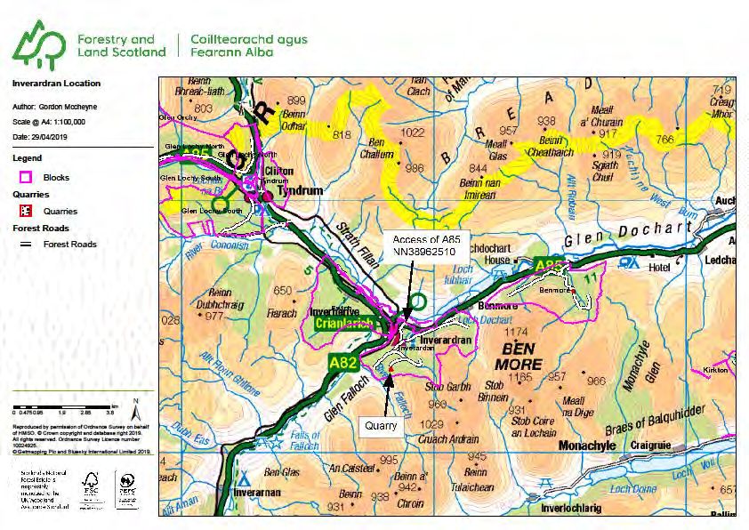
LMP Area Land Management Plan 2020-2030

2   |CRIANLARICH   |STEPHEN MURPHY   |   |25th November 2019
LMP Area Land Management Plan 2020-2030

                                                                                  CSM 6 Appendix 1b
FOREST AND LAND SCOTLAND - Application for Land Management Plan Approvals
in Scotland

Forest and Land Scotland - Property
Region:                                              Central
Woodland or property name:                           Crianlarich
Nearest town, village or locality:                   Crianlarich
OS Grid reference:                                   NN 421252
Local Authority district/unitary Authority:          LLTNP

Areas for approval
                                                    Conifer          Broadleaf
Clear felling                                       310.8
Selective felling
Restocking                                          175.0            135.7
New planting (complete appendix 4)
1. I apply for Land Management Plan approval for the property described above and in the
    enclosed Land Management Plan.
2. I apply for an opinion under the terms of the Environmental Impact Assessment (Forestry)
    (Scotland) Regulations 1999 for roads, tracks and quarries as detailed in my application.
3. I confirm that the initial scoping of the plan was carried out with FLS staff on 16th January 2018.
4. I confirm that the proposals contained in this plan comply with the UK Forestry Standard.
5. I confirm that the scoping, carried out and documented in the Consultation Record attached, incorporated
   those stakeholders which SF agreed must be included.
6. I confirm that consultation and scoping has been carried out with all relevant stakeholders over the
                                                    ark
   content of the of the land management plan. Consideration   of all of the issues raised by stakeholders has
   been included in the process of plan preparation and the outcome recorded on the attached consultation
   record. I confirm that we have informed all stakeholders about the extent to which we have been able to
   address their concerns and, where it has not been possible to fully address their concerns, we have
   reminded them of the opportunity to make further comment during the public consultation process.
7. I undertake to obtain any permissions necessary for the implementation of the approved Plan.

Signed       ………                              Signed……………………………………

              Regional Director                                 Conservator

Region        Central                                     Central Scotland Conservancy
                                              Conservancy……………………………………

25 November 2019                                                 29 June 2020
                                              Date of Approval……………………………………

                                                                   28 June 2030
                                              Date approval ends ………………………………..

3    |CRIANLARICH                 |STEPHEN MURPHY           |    |25th November 2019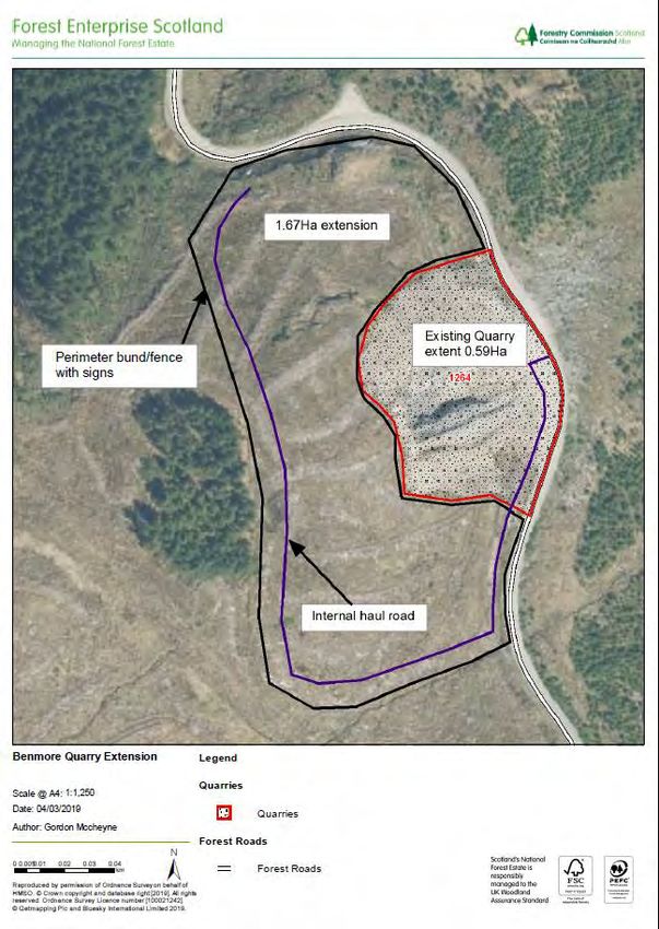
LMP Area Land Management Plan 2020-2030

4   |CRIANLARICH   |STEPHEN MURPHY   |   |25th November 2019
LMP Area Land Management Plan 2020-2030

                                                                     Environmental Impact
                                                                              Assessment
                                                            Screening Opinion Request
                                                                                       Form

Please complete this form to find out if you need consent from Forestry Commission
Scotland, under the Forestry (Environmental Impact Assessment) (Scotland)
Regulations 2017, to carry out your proposed forestry project. Please refer to
Schedule 2 Selection Criteria for Screening Forestry Projects under Applying for an
opinion. If you are not sure about what information to include on this form please
contact your local Conservancy office.

Proposed Work
Please put a cross in the box to indicate the type of work you are proposing to carry
out. Give the area in hectares and where appropriate the percentage of conifers and
broadleaves
                            Area in    %         % Broad-   Proposed             Area in
Proposed Work      select                                               select
                            hectares   Conifer   leaves     work                 hectares
                                                            Forest
Afforestation                                                                    7.8
                                                            roads
                                                            Forest
Deforestation
                                                            quarry
Location of work            Crianlarich Land Management Plan

 Description of Forestry Project and Location
 Provide details of the forestry project (size, design, use of natural resources such as
 soil, and the cumulative effect if relevant).
 Please attach map(s) showing the boundary of the proposed work and other known
 details.
 See section 3.0, Appendix III and relevant maps

 Provide details on the existing land use and the environmental sensitivity of the area
 that is likely to be affected by the forestry project.
 These are described in section 4.0 and 8.0 of the plan

 5   |CRIANLARICH             |STEPHEN MURPHY     |   |25th November 2019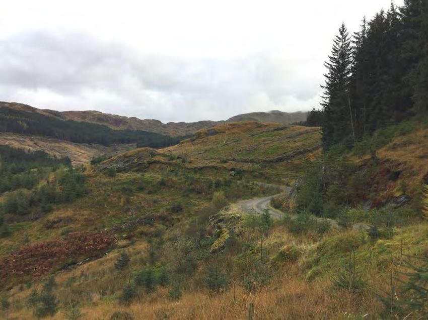
LMP Area Land Management Plan 2020-2030

Description of Likely Significant Effects
Provide details on any likely significant effects that the project will have on the
environment (resulting from the project itself or the use of natural resources) and the
extent of the information available to assist you with this assessment.
Some tracks and roads are visible from popular footpaths and tourist routes. Impacts
have been assessed through site visits and analysis in GIS and summarised in section
3.0 of the plan.

Include details of any consultees or stakeholders that you have contacted in order to
make this assessment. Please include any relevant correspondence you have received
from them.

Mitigation of Likely Significant Effects
If you believe there are likely significant effects that the project will have on the
environment, provide information on the opportunities you have taken to mitigate
these effects.
See section 3.0 and Appendix III of the plan.

Sensitive Areas
Please indicate if any of the proposed forestry project is within a sensitive area.
Choose the sensitive area from the drop down below and give the area of the proposal
within it.
Sensitive Area                                                            Area
National Park (NP)                                                        7.8ha
Select...

Property Details
Property Name:        Crianlarich
Business Reference                          Main Location
Number:                                     Code:

Grid Reference:                             Nearest town
                      NN 421252                             Crianlarich
(e.g. NH 234 567)                           or locality:

Local Authority:                            LLTNP

6   |CRIANLARICH            |STEPHEN MURPHY      |   |25th November 2019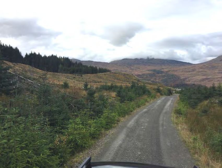
LMP Area Land Management Plan 2020-2030

Owner’s Details
Title:            Ms         Forename:    Shirley
Surname:          Leek
Organisation:     FLS                     Position:     Planning Manager
Primary Contact          0131 370 5674    Alternative Contact
Number:                                   Number:
Email:            enquiries.central@forestryandland.gov.scot
Address:          Forestry and Land Scotland
Central Region, Aberfoyle Office
Postcode:         FK8 3UX                 Country:
Is this the correspondence address?       Yes

Agent’s Details
Title:                       Forename:
Surname:
Organisation:                             Position:
Primary Contact                           Alternative Contact
Number:                                   Number:
Email:
Address:

Postcode:                                 Country:
Is this the correspondence address?       Select...

Office Use Only
GLS Ref number:

7    |CRIANLARICH           |STEPHEN MURPHY     |     |25th November 2019
LMP Area Land Management Plan 2020-2030

8   |CRIANLARICH   |STEPHEN MURPHY   |   |25th November 2019
LMP Area Land Management Plan 2020-2030

Contents
1.0 Summary of proposals
    1.1   Introduction
    1.2   Objectives
    1.3   Key Proposals
    1.4   Species diversity
    1.5   Major issues
    1.6   Critical success factors
    1.7   Standards and guidelines
    1.8   Consultation
    1.9   Contacts and further information

2.0 SF regulatory requirements
    2.1   Summary of planned operations
    2.2   Proposed felling in years 2020 – 2029
    2.3   Proposed thinning in years 2020 – 2029
    2.4   Proposed restocking in years 2020 – 2029
    2.5   Access and roading in years 2020 to 2029
    2.6   Departures from UKFS guidelines
    2.7   Tolerance table

3.0 EIA screening determination for forestry projects
    3.1   Proposed   deforestation
    3.2   Proposed   afforestation
    3.3   Proposed   forest roads, tracks and other facilities
    3.4   Proposed   quarries

4.0 Land management plan
    4.1   Introduction
    4.2   Setting and context
    4.3   Analysis and important issues
    4.4   Key challenges
    4.5   Concept
    4.6   Management objectives

9   |CRIANLARICH             |STEPHEN MURPHY     |    |25th November 2019
LMP Area Land Management Plan 2020-2030
5.0 Management proposals
5.1 Management
5.1.1 Clearfelling
5.1.2 Thinning
5.1.3 Potential for continuous cover forestry
5.2 Future habitats and species
5.3 Management of open land
5.4 Visitor zones and access
5.5 Deer management
5.6 Other (PAWS restoration etc.)
5.7 Restructuring
5.7.1 Summary
5.7.2 Species diversity
5.7.3 Age structure
6.0 Critical success factors
7.0 Management prescriptions
8.0 Background information
8.1 Previous plan
8.1.1 History of the plan
8.1.2 Analysis of previous plan
8.1.3 Continuity with revised plan
8.2 Physical site factors
8.2.1 Geology, soils and landform
8.2.2 Water
8.2.3 Climate
8.2.4 Future climate
8.3 Biodiversity and environmental designations
8.4 The existing forest
8.4.1 Species, age structure, and yield class
8.4.2 Access
8.5 Landscape and landuse
8.5.1 Visibility, landscape character and value
8.5.2 Neighbouring land use
8.6 Social factors
8.6.1 Recreation
8.6.2 Community
8.6.3 Heritage
10 |CRIANLARICH |STEPHEN MURPHY | |25th November 2019LMP Area Land Management Plan 2020-2030
Support documents: maps
1. Concept
2. Management zones
3. Management – all phases
4. Management – phases 1 and 2, including thinning
5. Future habitats and species – long term proposals
6. Conservation and heritage
7. Roads, tracks and quarries
8. Utilities
9. Footpaths and trails
10. Viewpoints
11. Species distribution
Support documents: perspectives
Appendices:
I) Consultation record
II) Scoping record
III) Quarry development plans
IV) Summary of operations
11 |CRIANLARICH |STEPHEN MURPHY | |25th November 2019LMP Area Land Management Plan 2020-2030 12 |CRIANLARICH |STEPHEN MURPHY | |25th November 2019
LMP Area Land Management Plan 2020-2030
1.0 Summary
1.1 Introduction
The Crianlarich Land Management Plan area consists of two forest blocks to
the south and east of the village. The northern and western boundaries are
defined by the A82 and A85 trunk roads, while the south and east is open
land rising to several peaks over 3000 feet elevation. The total area is
1379ha of which 653ha (47%) is woodland. The woodlands are dominated
by commercial Sitka spruce plantation and all other species amount to only
25% of the area of that species. A process of restructuring aimed at
increasing both age and species diversity has been ongoing for the past 10
to 15 years and a key objective of the new plan is to continue this process:
in particular to restore ancient woodland sites that have been planted with
non-native conifer.
Timber production using non-native species will remain an important part of
management in Crianlarich but there are a number of other key issues that
will be addressed. These include taking into account the visibility and
landscape setting of the woodlands, protection and possible expansion of
key habitats and designated sites and protection of heritage features.
1.2 Objectives
Continue the process of restructuring aiming to create a diverse, resilient
forest delivering a range of ecosystem services.
Establish a definitive ancient woodland restoration area, using this as a
framework for restocking proposals.
Seek to expand native woodlands and integrate these into wider habitat
networks.
Outside the habitat networks maximise production using Sitka spruce as
the predominant species in a clearfell management system.
Establish a coupe structure that takes account of windblow risk on steep
slopes, clearfelling before this becomes unacceptable.
Use climate, site and operational constraints to inform species choice,
avoiding productive forestry on sites that might give poor economic
returns or are potentially unstable.
Manage ground within black grouse lek zones to favour that species.
Manage Benmore SSSI as per updated management plan and keep
invasion by SS to within acceptable tolerances.
Maintain perimeter deer fence and establish a system of deer control
appropriate to the species to be established.
Seek to soften landscape impacts where these are obtrusive.
13 |CRIANLARICH |STEPHEN MURPHY | |25th November 2019LMP Area Land Management Plan 2020-2030
1.3 Key proposals
Total Plan Area 1379 (ha)
Planned operations
Felling 310.8ha.; 152350m3
Thinning 140.0ha; 7000m3
Restock 175.0ha of conifer; 135.7ha of broadleaf.
New planting 0ha
Roads and tracks 2875m road; 26500m track; 75 ramps; 14975m road upgrade
Public access
1.4 Species diversity
Species group 2020 2030 2040
Sitka spruce 43.9% 37.1% 34.8%
Other conifers 5.2% 3.3% 2.9%
Scots pine 1.0% 2.1% 2.4%
Native broadleaves 9.0% 14.7% 16.4%
Open space 40.9% 42.8% 43.5%
1.5 Major issues
Issue Description/mitigation
Issue 1 Mature trees on steep slopes in eastern part of Benmore block
with no access. Build road, fell early in plan period to minimise
wind risk.
Issue 2 Extensive areas of plantation on ancient woodland sites.
Establish extent of ancient woodland and restore.
Issue 3
Issue 4
1.6 Critical success factors
The following are critical to success of the plan:
Timely construction of new, or upgrading of existing, roads, and
roads/tracks to access approved felling coupes.
Adequate deer control measures for protection of broadleaved species
and soft conifers.
1.7 Standards and guidelines
This plan takes account of Scottish Government and Forestry and Land
Scotland policy and strategy. It has been developed in accord with the
latest UKFS Guidelines and is audited under the UK Woodland Assurance
Standard. Guidance in Planting in Caledonian pinewoods: reducing risks
from Dothistroma Needle Blight (2017) will be followed when establishing
native woodland in the vicinity of Glen Falloch SSSI. Guidance on Seed
Sources for Planting Native Trees and Shrubs in Scotland will be followed
14 |CRIANLARICH |STEPHEN MURPHY | |25th November 2019LMP Area Land Management Plan 2020-2030
when restoring Plantations on Ancient Woodland Sites to native woodland.
Forestry and Land Scotland Woodlands are certified as being sustainable by
both FSC and PEFC.
1.8 Consultation
During the development of this plan we have consulted with stakeholders
known to have an interest in this plan area. A list of stakeholders and their
response can be found in Appendix I.
1.9 Contacts and further information
For further information on this or any other land management plan please
contact:
Forest and Land Scotland
enquiries.central@forestryandland.gov.scot
Aberfoyle
FK8 3UX
tel. 0131 370 5674
15 |CRIANLARICH |STEPHEN MURPHY | |25th November 2019LMP Area Land Management Plan 2020-2030
2.0 Scottish Forestry regulatory requirements
2.1 Context and rationale for concept
Crianlarich combines two forest blocks to the south and east of the village.
It is situated amidst dramatic mountain scenery where two important
transport routes meet, at the junction of Glen Falloch and Glen Dochart. The
woodlands have been dominated by commercial spruce plantations and re-
structuring of relatively even aged forests has been ongoing for some years.
The plan continues the restructuring process and takes into account key
landscape and environmental issues whilst maintaining a large element of
productive forestry.
2.2 Proposed felling in years 2021 – 2030
Phase Area (ha) Volume (m3)
1 195.5 105900
2 115.3 46450
310.8 152350
Table 2.1 Summary of felling proposals
Map M4 shows the coupes for which approval is being sought for clearfelling
and thinning during the plan period. These are set in the context of longer
term management proposals in Map M3. The future habitats map (M5)
should also be referred to.
2.3 Proposed thinning in years 2021 – 2030
Phase Area (ha) Volume (m3)
1 40.0 2000
2 100.0 5000
140.0 7000
Table 2.2 Summary of thinning proposals
Proposed thinning coupes are shown on map M3 and further detail found in
section 5.1.2.
2.4 Proposed restocking in years 2021 – 2030
Phase Species Area (ha)
1/2 Conifer 175.0
1/2 Broadleaf 135.8
310.8
Table 2.3 Summary of restocking proposals
Restocking proposals are shown on map M5 and further details found in
section 5.2. The overall objective has been to maintain a high level of
production whilst introducing greater diversity and restoring large areas of
plantation on ancient woodland sites.
16 |CRIANLARICH |STEPHEN MURPHY | |25th November 2019LMP Area Land Management Plan 2020-2030
Where production is the key objective conifers will be planted at densities of
approximately 2700 stems per hectare (sph) and broadleaves in the region
of 3500. Restocking will be within two years of felling unless Hylobius
Management Support System indicates a longer fallow period is necessary.
In the latter case planting will be carried out within five years.
Where production is not the key objective target densities for planting, or
natural regeneration, of native and non-native species, will vary depending
on site objectives. On planted sites and the majority of natural regeneration
sites an overall density of at least 1600sph will be achieved; in transitional
areas, such as upper treelines, lower densities, of at least 1100sph, will be
accepted. Natural regeneration sites will be assessed four years after felling.
If it seems unlikely regeneration will become established by year 5, the site
will be planted to achieve the desired stocking level.
Open areas will be allowed up to 20% tree cover. Non-native species will be
managed to meet aspirations to restore Plantations on Ancient Woodland
Sites (PAWS). Small amounts of rhododendron are known to be present and
appropriate measures to control this species will be put in place.
2.5 Access and roading in years 2021 – 2030
Phase Species Length (m) Area (ha)
1/2 New roads 2875 2.0
1/2 Tracks/ramps 26500 5.8
23205 7.8
Table 2.4 Summary of roads and tracks
Proposed roads and tracks are shown on map M7 and more detail is to be
found in section 3.0.
2.6 Departures from UKFS guidelines
There are no departures from UKFS guidelines. Coupes 57029 and 57031
are being treated as the same coupe; coupes 58060 and 58042 will also be
treated as one coupe and felled at the same time.
17 |CRIANLARICH |STEPHEN MURPHY | |25th November 2019LMP Area Land Management Plan 2020-2030
2.7 Tolerance table
Adjustment to Adjustment to Timing of restocking Change to restocking Changes to road lines Designed open ground Windblow
felling period felling coupe species clearance
boundaries
SF Approval not Felling date can be Up to 10% of coupe Up to 2 planting seasons Change within species Increase by up to 5% of
normally required moved within 5 year area (up to a after felling group e.g. evergreen coupe area
period where maximum of 1ha) conifers or broadleaves
separation or other
constraints are met
Approval by Up to 15% of coupe Between 2 and 5 Additional felling of trees Increase by up to 10% Up to 5ha
exchange of letters area planting seasons after not agreed in plan Any reduction in open
and map felling subject to the Departures of more than ground within coupe
wider forest and habitat 60m in either direction area
structure not being from centre of roadline
significantly
compromised
Approval by formal Felling delayed into More than 15% of More than 5 planting Change from specified As above, depending on More than 10% of More than 5ha
plan amendment second or later coupe area seasons after felling native species sensitivity coupe area
including map period. subject to the wider Change between species Colonisation of open
Felling advanced into forest and habitat groups areas agreed as critical
earlier 5 year period structure not being
significantly
compromised
18 |CRIANLARICH |STEPHEN MURPHY | |25th November 2019LMP Area Land Management Plan 2020-2030
3.0 EIA screening determination for forestry projects
3.1 Proposed deforestation
There are no deforestation proposals.
3.2 Proposed afforestation
There are no afforestation proposals.
3.3 Proposed forest roads, tracks and other facilities
This is a request for an EIA determination for works covering construction of,
roads, tracks, ramps and other facilities in Crianlarich LMP area. The request
covers proposals for the full ten year period of the plan which will offer some
flexibility with the work programme without the necessity of having to re-submit
a determination. Any work to be carried out in the second half of the plan period
will be preceded by a new EIA determination request.
Several new lengths of road will be required to facilitate access to harvesting
coupes for machinery and timber lorries. The total length is about 2875m with a
footprint about 7m wide. The nominal area is 2.0ha. The proposed roads will be
constructed to the standard FLS Class A road specification and in line with the
principles described in the SNH guidance on Constructed Tracks in the Scottish
Uplands. Construction will also conform to the Forest and Water Guidelines (Fifth
Edition). Roads will have a waterbound surface (not tarmac), with one layby at
about 500m intervals and with a turning point at the end.
The road lines have been selected to follow the site topography and to minimise
cut and fill. The impact of the road construction will be further reduced by
ensuring batter angles and, in general, the disturbed ground, is left in a
condition that will promote early natural vegetation regeneration. The location of
turning points and laybys will be carefully selected to minimise disturbance and
the batter angle of any cut required in construction. Where possible laybys and
turning points will be positioned on the downhill side of the new roads. Also,
where possible top soil stripped from the roadline will be stored to be used for
landscaping after construction. As an additional measure, given the landscape
sensitivities, groups of native trees will be planted at appropriate points to help
screen the road from the surrounding area.
A proportion of the materials required to construct roads may be sourced from
within the excavation corridor the remainder will come from the closest available
FLS quarry.
Approximately 26500m of forwarder and ATV tracks will be required to access
harvesting sites and to facilitate harvesting, silvicultural and deer management
operations. In addition, up to 75 ramps will be required to allow
harvester/forwarder access into coupes that are to be felled during the design
plan period.
19 |CRIANLARICH |STEPHEN MURPHY | |25th November 2019LMP Area Land Management Plan 2020-2030
It is estimated that about 2300m of forwarder extraction track will be required.
Construction will be kept to a minimum, but where it is required material will be
sourced either from the line of the track or the nearest FLS quarry. The surface
of extraction tracks will be protected with a layer of branches and tops.
Forwarder tracks will be approximately 3m to 4m wide with a nominal area of
about 0.7ha. When no longer needed for extraction the width will be narrowed to
2.5m and both track and batters will be allowed to revegetate.
The total length of ATV tracks will be approximately 24200m and they will be
about 2m wide; the nominal area amounts to 4.8ha. ATV tracks will be
constructed in line with the principles described in the SNH guidance on
Constructed Tracks in the Scottish Uplands. Construction will also conform to the
Forests and Water Guidelines (Fifth Edition). During construction ground
disturbance will be kept to a minimum. ATV tracks will not be treated as
permanent features; once operations are complete tracks will be allowed to
grass over and the running surface and side batters will be left in a condition
that will promote vegetation regeneration. Tracks will be constructed with a top-
side drain and will have regular drainage cut-offs to prevent erosion of the
trackside drain. No water from the trackside drains will discharge directly into
any watercourse.
Indicative positions of the roads and tracks are shown on the roads and tracks
map (M7) and final positions will be within ± 60m of these. The actual lines will
be planned to minimise landscape impact and ground disturbance, reflecting
existing topography, avoiding steep gradients where possible and avoiding
sensitive habitats.
Ramps will be approximately 3m wide and up to about 15m long. The total
nominal area is approximately 0.34ha. They will not be treated as permanent
features and will be removed following operations. The final number and location
of the ramps will be determined at the time of operations but we believe one
ramp per 100m of road/coupe interface will be sufficient.
A summary of roads and tracks is found in the table in section 3.5.
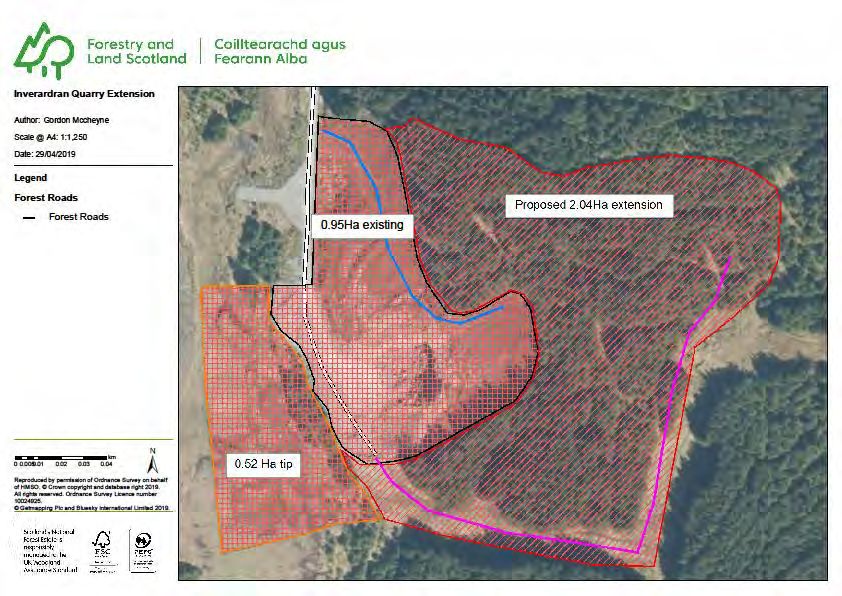
3.4 Proposed quarries
There are two quarries in the plan area for which extensions are proposed during
the lifetime of the plan. These quarries will provide vital aggregate for the
construction of new roads and maintenance of existing roads essential for
delivery of the felling programme. Using quarries located within the forest block
will reduce traffic on public roads and result in lower carbon emissions. The
quarry locations are indicated on the roads and tracks (map M7). Quarry
development plans (see Appendix III) provide additional information.
Given the landscape sensitivities of these developments a separate screening
opinion request will be submitted for them.
20 |CRIANLARICH |STEPHEN MURPHY | |25th November 2019LMP Area Land Management Plan 2020-2030
3.5 Screening opinion request summary
Length
Coupe Area (ha.) Purpose Landscape Water quality Archaeology Biodiversity Access Recreation Material
(m)
access for
standard
harvesting no significant nearest FLS
57002 267 0.19 no major impact protection no known issues from forest road n/a
machinery and issues quarry
measures
timber lorries
access for
standard
harvesting partially visible no significant nearest FLS
57031 993 0.70 protection no known issues from forest road n/a
machinery and from A85 issues quarry
measures
timber lorries
access for
visible from standard
harvesting no significant nearest FLS
58025 751 0.53 summit of protection no known issues from forest road n/a
machinery and issues quarry
Cruach Ardrain measures
timber lorries
access for
visible from standard
harvesting no significant nearest FLS
58046 862 0.60 Benmore hill protection no known issues from forest road n/a
machinery and issues quarry
paths measures
timber lorries
visible from standard
access for no significant nearest FLS
57001 328 0.10 Benmore hill protection no known issues from forest road n/a
harvesting issues quarry
path measures
standard
access for no significant nearest FLS
57028 708 0.18 no major impact protection no known issues from forest road n/a
harvesting issues quarry
measures
standard
access for partially visible no significant nearest FLS
57029 844 0.25 protection no known issues from forest road n/a
harvesting from A85c issues quarry
measures
visible from standard
access for no significant nearest FLS
58001 289 0.09 West Highland protection no known issues from forest road n/a
harvesting issues quarry
Way measures
standard
access for no significant nearest FLS
58033 159 0.05 Visible from A85 protection no known issues from forest road n/a
harvesting issues quarry
measures
21 |CRIANLARICH |STEPHEN MURPHY | |25th November 2019LMP Area Land Management Plan 2020-2030
Screening opinion request summary continued
Length
Coupe Area (ha.) Purpose Landscape Water quality Archaeology Biodiversity Access Recreation Material
(m)
crop
visible from standard
establishment no significant from forwarder to be found on
57001 783 0.16 Benmore hill protection no known issues n/a
and deer issues track site
path measures
management
crop
visible from standard
establishment no significant to be found on
57002 771 0.15 Benmore hill protection no known issues from forest road n/a
and deer issues site
path measures
management
crop
visible from standard
establishment no significant to be found on
57003 645 0.13 Benmore hill protection no known issues from forest road n/a
and deer issues site
path measures
management
crop
standard
57004/ establishment no significant to be found on
1686 0.34 no major issues protection no known issues from forest road n/a
57005 and deer issues site
measures
management
crop
standard
establishment no significant to be found on
57006 628 0.13 no major issuesc protection no known issues from forest road n/a
and deer issues site
measures
management
crop
standard
establishment no significant to be found on
57010 1308 0.26 no major issues protection no known issues from forest road n/a
and deer issues site
measures
management
crop
standard
establishment area of bog and close to forest to be found on
57014 527 0.11 no major issues protection no known issues from forest road
and deer open water entrance site
measures
management
crop
standard crosses existing
establishment no significant to be found on
57018 565 0.11 no major issues protection no known issues from forest road Benmore hill
and deer issues site
measures path
management
crop
standard
establishment no significant to be found on
57023 822 0.16 no major issues protection no known issues from forest road n/a
and deer issues site
measures
management
22 |CRIANLARICH |STEPHEN MURPHY | |25th November 2019LMP Area Land Management Plan 2020-2030
Screening opinion request summary continued
Length
Coupe Area (ha.) Purpose Landscape Water quality Archaeology Biodiversity Access Recreation Material
(m)
crop
standard
establishment no significant to be found on
57025 897 0.18 no major issues protection no known issues from forest road n/a
and deer issues site
measures
management
crop
standard
establishment no significant to be found on
57029 540 0.11 visible from A85 protection no known issues from forest road n/a
and deer issues site
measures
management
crop
standard
establishment no significant to be found on
57031 1149 0.23 visible from A85 protection no known issues from forest road n/a
and deer issues site
measures
management
crop
standard
establishment no significant to be found on
57028 944 0.19 no major issues protection no known issues from forest road n/a
and deer issues site
measures
management
crop
visible from A82 standard
establishment no significant from forwarder to be found on
58001 1197 0.24 and West protection no known issues n/a
and deer issues track site
Highland Way measures
management
crop
visible from A82 standard
establishment no significant to be found on
58004 1545 0.31 and West protection no known issues from forest road n/a
and deer issues site
Highland Way measures
management
crop
visible from A82 standard
establishment no significant to be found on
58012 1642 0.33 and West protection no known issues from forest road n/a
and deer issues site
Highland Way measures
management
crop
standard
establishment May be visible no significant to be found on
58018 413 0.08 protection no known issues from forest road n/a
and deer from A85 issues site
measures
management
crop
visible from standard
establishment no significant to be found on
58025 1233 0.25 summit of protection no known issues from forest road n/a
and deer issues site
Cruach Ardrain measures
management
23 |CRIANLARICH |STEPHEN MURPHY | |25th November 2019LMP Area Land Management Plan 2020-2030
Screening opinion request summary continued
Length
Coupe Area (ha.) Purpose Landscape Water quality Archaeology Biodiversity Access Recreation Material
(m)
crop several hairpins
standard
establishment but not clearly no significant to be found on
58027 1406 0.28 protection no known issues from forest road n/a
and deer visible from issues site
measures
management major viewpoints
crop
visible from A82 standard
establishment no significant to be found on
58029 979 0.20 and West protection no known issues from forest road n/a
and deer issues site
Highland Way measures
management
crop
standard
establishment may be visible no significant to be found on
58033 474 0.10 protection no known issues from forest road n/a
and deer from A85 issues site
measures
management
crop
visible from standard
establishment no significant to be found on
58042 571 0.10 Benmore hill protection no known issues from forest road n/a
and deer issues site
path measures
management
crop
visible from standard
establishment no significant to be found on
58044 1019 0.20 Benmore hill protection no known issues from forest road n/a
and deer issues site
path measures
management
crop
standard
establishment visible from hill no significant to be found on
58046 1275 0.26 protection no known issues from forest road n/a
and deer paths issues site
measures
management
crop
visible from standard
establishment no significant to be found on
58060 1159 0.23 Benmore hill protection no known issues from forest road n/a
and deer issues site
path measures
management
24 |CRIANLARICH |STEPHEN MURPHY | |25th November 2019LMP Area Land Management Plan 2020-2030
4.0 Land management plan
4.1 Introduction
This is a re-submission of a plan first developed by Forest Enterprise Scotland
(now Forestry and Land Scotland) in 2007. This plan continues the work of re-
structuring described in the previous work but sets it in the context of revised
aspirations and policy. A summary of the plan proposals is found in section 1,
whilst sections 2 and 3 deal with Scottish Forestry regulations and EIA screening
requirements respectively. This section covers the context, key issues and the
broad proposals of the plan. Section 5 provides greater detail on management
proposals summarised in previous sections. Section 6 repeats the critical success
factors and section 7 summarises broad management prescriptions. Background
information is found in section 8. Several appendices deal with the consultation
process, proposed quarry development and provide a summary of management
proposals in tabular form.
4.2 Setting and context
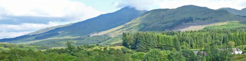
The Crianlarich Land Management Plan area (see Figure 4.1) is located on the
northern slopes of Ben More to the south and east of the village of the same
name. The village itself sits at a key transport junction where Glen Falloch meets
Glen Dochart. The plan area is split into two blocks, Inverardran and Benmore
and covers a total of 1379ha about half of which is open ground. It is wholly
within the Loch Lomond and the Trossachs National Park and is bordered by
significant designated sites.
4.3 Analysis and important issues
Factors that have been taken into account in developing the LMP proposals are
summarised in the analysis and context (map M1) these include:
Extensive areas of plantation on ancient semi-natural woodland. FLS is
committed to restoring the majority of such sites.
Steep slopes which are potentially unstable, though not necessarily
threatening key infrastructure.
Recently constructed hydro scheme in Caorach Glen.
Cool, wet climatic conditions and large areas of wet acidic soil.
Significant designated sites including Benmore SSSI, Glen Falloch SSSI
and River Tay SAC.
Known black grouse leks nearby.
Located next to important transport corridors.
Popular walking routes.
High landscape value.
25 |CRIANLARICH |STEPHEN MURPHY | |25th November 2019LMP Area Land Management Plan 2020-2030
Figure 4.1 Crianlarich: location
4.4 Key challenges and liabilities
Significant challenges are:
The reduction in the area for commercial spruce forest through
implementation of the PAWS policy.
Significant areas of PAWS restoration requiring rapid establishment of
native woodland and removal of non-native natural regeneration.
Small areas of steep ground which may be uneconomic to restock with
spruce but do not fall within native woodland restoration areas.
Potentially unstable ground.
4.5 Concept
The Analysis and Concept (map M1) summarises how the important issues will
be addressed, including:
Identification and restoration of PAWS and extending the area of native
woodland around these.
Assessing slope instability and adopting management options suitable for
these situations.
Protection of all third party infrastructure.
Taking into account site conditions when selecting species for restocking.
Protecting designated sites and seeking opportunities to enhance/extend
similar habitats.
Extend similar protection to priority species on FLS ground.
Protect landscape value of the area.
26 |CRIANLARICH |STEPHEN MURPHY | |25th November 2019LMP Area Land Management Plan 2020-2030
4.6 Management objectives
Plan objectives are to be found in section 1.2. Broad objectives are illustrated in
the management zones (map M2) though it should be stressed that there will be
overlap between zones.
5.0 Management plan proposals
5.1 Management
Management will be guided by the key objectives of the plan. The main
management technique will be clearfelling and re-planting.
5.1.1 Clearfelling
Map M4 shows the coupes for which approval is being sought for clearfelling
during the plan period. These are set in the context of longer term management
proposals in Map M3.
Table 5.1 indicates net felling area and volume figures for the plan area for the
first two phases. These values are approximate and coupes will be surveyed to
provide more precise figures prior to felling. A breakdown of species to be felled
is to be found in Appendix IV.
Phase Area (ha) Volume (m3)
1 195.5 105900
2 115.3 46450
310.8 152350
Table 5.1 Proposed felling
The proposed felling sequence is a balance between achieving optimum
economic return and timber quality, minimising risk of wind damage and
retention of some of the older trees in the medium term. Models recently
developed by Forest Research and FLS suggest optimum cost recovery and
timber quality is achieved when trees are between 40 and 50 years old. The
timing and spatial distribution of felling coupes fall within the parameters set out
in the UK Forest Standard to minimise risk of flooding and deterioration of water
quality. Retention of some stands for a longer period will aid restructuring,
improving future resilience and achieving a better age class balance. Coupes
which would be difficult to harvest, if extensive windblow occurred, have been
brought in to the phase 1 or 2 felling periods. Other coupes, of a similar age,
have been retained.
In Benmore coupes 57031 and 57029 will be felled together. These both require
a new road to be constructed for access and, additionally, a forwarder track for
57029. The latter is steep and will be difficult and dangerous to harvest if
windblow does occur; felling within the plan period will lower that risk. The
option of delaying coupe 57031 has been considered but, given the relatively
high yield class of the trees here, it is believed risk of wind damage will become
unacceptable if felling is delayed. Consideration has also been given to retaining
27 |CRIANLARICH |STEPHEN MURPHY | |25th November 2019LMP Area Land Management Plan 2020-2030
coupe 57001 for a longer period of time. However given its prominent position in
the landscape, and the presence of both larch and windblow, a decision has been
taken to fell it during the plan period.
In Inverardran a similar approach of balancing windrisk and a desire to improve
age structure has been taken. This is seen, for example, in Benmore Glen.
Coupe 58141 has been included in the first phase so that larch that might be
accessible when either 58033 or 58060 are felled can be removed. In addition
coupes 58042 and 58060 will be treated as one for felling purposes.
All harvesting operations will be carried out in accordance with the UK Forestry
Standard Guidelines, and Forest and Water Guidelines (5th edition). Although
Slope Stability and Risk (STAR) assessments concluded that no further
geotechnical assessments would be required best practice will be observed
during operations, to minimise risk of debris flows and rock falls. Prior to
operations any known heritage features will be marked to ensure protection
during the operation. Also felling coupes will be checked for protected species
prior to crop surveys and operations and SNH guidelines for managing these
during felling operations followed. All Schedule 1 species found on FLS ground
will be monitored annually. Where necessary public access will be managed so
as to reduce disruption without compromising safety. Potential impacts on
infrastructure will be taken into account during operational planning and the
relevant organisation contacted prior to operations. In particular both public and
private water supplies will be protected during harvesting operations.
5.1.2 Thinning
Indicative thinning coupes for which approval is sought are shown on map M4,
Management phases 1 and 2.
The work includes first and second thinning and some stands will receive two
thinnings in the plan period. The area and volume figures for the second
thinnings are incorporated into the overall figures.
This first indication of suitable stands was based on the following criteria:
Planting year 1998 to 2008
Slope ≤30%
DAMS score (exposure) ≤14
Soil type (from maps)
Accessibility
A more detailed assessment of the stands will be made at the operational
planning phase and a final decision whether to proceed with the work will be
made at that point. Stands will be thinned to marginal thinning intensity,
dependent on survey data. Racks will be cut at appropriate spacing and matrix
trees taken to achieve the recommended thinning intensity.
28 |CRIANLARICH |STEPHEN MURPHY | |25th November 2019LMP Area Land Management Plan 2020-2030
5.1.3 Potential for Continuous Cover Forestry
Although site conditions exist that would favour the use of CCF techniques no
coupes have been identified that would justify using them at present, largely due
to the age of trees in relation to site conditions. In the future the best
opportunities for CCF will be found in the native woodland zone.
5.2 Future habitats and species
The management zones map (map M2) indicates the broad aspiration for future
habitats which are shown in more detail in the future habitats map (map M5).
Further information is found in Appendix IV.
Table 5.2 summarises the establishment proposals for the plan area beyond the
first two phases.
Phase Species Area (ha)
1/2 Conifer 175.0
1/2 Broadleaf 135.8
Total 310.8
Table 5.2 Proposed establishment
Climate and site conditions restrict the use of species for commercial production
to lower elevations and even here wet acidic ground does not favour many
alternatives to Sitka spruce. The latter will remain the species of choice over
much of the plan area but opportunities will be sought for using other species.
The favoured candidate is Norway spruce which has already established well on
some sites. Scots pine will be considered for drier acidic sites using native
origins close to the Glen Falloch SSSI. Where large areas of pure Sitka spruce
are indicated these will be broken up along riparian zones and by not planting
very poor ground. It is not possible to show this in detail until sites can be
assessed following clearfelling. Where feasible the use of broadleaved species
will also be used to add visual and species diversity.
A mixed Scots pine habitat will be established in the vicinity of the Glen Falloch
SSSI. This will include elements of native broadleaves and open space; if pine is
slow to establish, native broadleaves will help protect the soil surface in the
short to medium term. Because of the risk from Dothistroma Needle Blight Scots
pine will not be planted within 600m of the SSSI and natural regeneration will be
the preferred method of establishment. Impacts from browsing animals will be
minimised through a combination of culling and fencing. The site will be
monitored and if natural regeneration of pine seems unlikely to occur other
options, such as ground preparation, with or without direct seeding, will be
considered. If planting does become necessary, this will be a last resort and FLS
will consult with both Scottish Natural Heritage and Scottish Forestry. If seeding
or planting is used as the method of regeneration, guidance on obtaining local
seed sources will be adhered to.
Native woodland will be established on PAWS sites and the original area
expanded where the ancient woodland distribution limits the use of non-native
productive conifers such as Sitka spruce. In Benmore the native woodlands will
29 |CRIANLARICH |STEPHEN MURPHY | |25th November 2019LMP Area Land Management Plan 2020-2030
be a mix of oak, birch and Scots pine, though other native species will also be
encouraged. Where there are adequate seed sources natural regeneration will be
the preferred establishment option. Elsewhere, or where natural regeneration is
not developing quickly enough, planting will take place. For both broadleaves
and Scots pine local provenances will be used wherever possible.
In general the existing commercial treeline will be lowered when the ground is
restocked. This is for both commercial and landscape reasons. Mixed natural
regeneration will be allowed in these areas though the percentage of non-native
species will be kept within acceptable tolerances adjacent to SSSIs.
At restocking adequate buffer zones will be created around public and private
water supplies as per Forest and Water Guidelines.
5.3 Management of open land
Open land ranges from high elevation hillsides and plateaus to riparian and bog
habitat at lower elevations. It includes roadlines wayleaves and other open space
around buildings, for example.
Roads will be routinely maintained during the plan period and this will include
drain maintenance and removal of natural regeneration where it interferes with
the integrity and use of the road. Wayleaves will also be kept open and managed
in accordance terms agreed with the relevant utility companies.
Much of the open space within woodland areas will be considered transient and
is not mapped. Buffer areas around riparian zones will not be restocked with
commercial conifer, as per guidelines, but an open woodland habitat will be
allowed to develop. In this case non-native species will be kept to within
tolerable limits.
5.4 Visitor zones and access
The area around the entrance to Inverardran will be managed in association with
the local community. The aim will be to maintain footpaths and create a pleasant
and diverse system of woodland walks. Some small trees may be removed
during the plan but volumes will be small and are incorporated into the overall
thinning figures. Informal access to open hill will not be restricted but routes will
not be maintained.
5.5 Deer management
Forestry and Land Scotland carry out deer control as part of a collaborative
effort with Balquhidder Deer Management Group. The two sections form a single
deer management unit and deer control is carried out under contract. Deer
numbers have been relatively high in recent years and there have been high
levels browsing of soft conifer, especially in Inverardran. The number of deer
shot in the plan area has been increased as part of a programme to reduce
background numbers of deer. Both sections are surrounded by a perimeter deer
fence, though this is compromised in several places and ongoing repairs will be
necessary. In the long term the intention is to maintain the perimeter fence to a
high standard and reduce deer numbers within the LMP area. This should allow
for less reliance on fencing of individual coupes. In the short term restock
30 |CRIANLARICH |STEPHEN MURPHY | |25th November 2019LMP Area Land Management Plan 2020-2030
coupes will be assessed on a case by case basis and additional internal fencing
used where necessary. Where deer fences cross marked routes pedestrian gates
will be installed if required. Where appropriate deer fences will be marked to
minimise risk of bird collisions.
Part of deer management will include the creation and maintenance of deer
glades. Size and location of these will be determined during operational
planning.
5.6 Other proposals
Road maintenance will proceed as and when necessary during the plan period.
This might include removal of roadside vegetation including occasional trees in
excess of 10cm dbh. Similarly management associated with wayleaves and other
facilities may include removal of some larger individuals or groups of trees. The
volumes involved will not amount to more than 40m3 per annum.
There are two quarries that will be developed during the lifetime of the plan.
More details can be found in appendix II. It is unclear how much of the proposed
extensions will take place during the plan period as this is very much dependent
on stone requirements. However the developments are included in the SOR
found at the beginning of the plan.
5.7 Restructuring
5.7.1 Summary
The felling proposals continue the process of restructuring the forest developed
in previous plans. The aim of restructuring is to gradually convert a largely even
aged, single species woodland into one with a more balanced age structure and
a more diverse species range. It is believed that a more diverse forest
encourages greater resilience to both disease and damage from extreme climatic
events. Creating a coupe structure where adjacent coupes are not felled and
restocked within five to fifteen years of each other is a standard method of
achieving diversity. So called “adjacency” issues have been avoided as far as
possible. The retention of several stands beyond the age of 60years will afford
improved age structure and resilience in the medium to long term. Permanent
woodland and a mix of open ground and natural regeneration along riparian
zones both within and outside the FHN will further improve resilience.
5.7.2 Species diversity
Table 5.3 indicates the change in relative species composition between 2020 and
2040. There is a reduction in the amount of Sitka spruce relative to other
species over the 20 year period, but it remains the dominant species. There is
also a relatively large reduction in the amount of other conifers especially
Norway spruce and lodgepole pine. The amount of larch is reduced as a response
to the threat of Ramorum disease. Diversity is maintained due to the significant
increase in native broadleaves. The figures for open space include areas awaiting
restocking.
31 |CRIANLARICH |STEPHEN MURPHY | |25th November 2019LMP Area Land Management Plan 2020-2030
Species 2020 2030 2040
Sitka spruce 43.9% 37.1% 34.8%
Birch 9.0% 14.7% 16.4%
Scots pine 1.0% 2.1% 2.4%
Other conifer 5.2% 3.3% 2.9%
Open 40.9% 42.8% 43.5%
100% 100% 100%
Table 5.3 Change in species diversity over time
5.7.3 Age structure
Table 5.4 shows the change in relative age structure between 2020 and 2040.
These figures indicate that it will take some time to achieve a balanced age
structure. There is an early fall in older age classes which will not be fully
compensated for till after 2040.
Age Class 2020 2030 2040
0-10 13.7 44.1 29.7
11-20 21.0 8.1 35.3
21-40 0.0 21.7 29.9
41-60 64.0 0.3 0.0
60+ 1.4 25.8 5.0
100.0 100.0 100.0
Table 5.4 Age structure in Crianlarich (percent of forested area)
6.0 Critical success factors
The following are critical to success of the plan:
Timely construction of new, or upgrading of existing, roads, and
roads/tracks to access approved felling coupes.
Adequate deer control measures for protection of broadleaved species and
soft conifers.
32 |CRIANLARICH |STEPHEN MURPHY | |25th November 2019LMP Area Land Management Plan 2020-2030
7.0 Management prescriptions
Clearfelling is the dominant management system that will be used. Coupe design
takes into account topography, landscape and operational constraints and is
intended to facilitate future restructuring. Age of clearfelling will generally be in
the range 40 to 60 years.
Some younger stands will be thinned and these will be assessed beforehand to
determine the most suitable methodology. In general thinning will be to
marginal thinning intensity. A rack system will be established with racks at
appropriate intervals, any outstanding volume being taken from the matrix. The
potential to continue thinning into the future will be assessed on a stand by
stand basis.
Restocking for productive purposes will be by planting following any necessary
site preparation. The latter will include brash management, necessary drainage
and, in general, mounding to provide a sheltered weed free planting site. On
steep ground flat planting might be necessary. Fallow periods will be used to
help mitigate weevil damage in line with aspirations to minimise use of chemical
deterrents. Softer species may be protected by fencing from animal browsing.
Large areas will be left for natural regeneration, the success of which will be
monitored.
8.0 Background information
8.1 Previous plan
8.1.1 History
This is the second plan for the Crianlarich block the first having been produced in
2007 by the then Lorne Forest District. The block is an amalgamation of two
closely related but separate blocks, Inverardran and Benmore. The first planting
took place in 1959 and was completed by the late 1960s. The vast majority of
the block was planted with Sitka spruce only small amounts of other species,
including larch and Norway spruce, being used. The clear intention was to
establish a productive forest and the previous plan examined ways in which a
range of other objectives could be achieved without overly compromising
production. This plan takes into account the aspirations of the previous plan and
builds on these in light of changing policy.
8.1.2 Analysis of previous plan
The broad aims of the previous plan were:
To maintain timber production
Align with aspirations of the newly established Loch Lomond and the
Trossachs national Park.
Expand the area of native woodland
33 |CRIANLARICH |STEPHEN MURPHY | |25th November 2019LMP Area Land Management Plan 2020-2030
In addition a range of wider potential benefits were described, including an
intention to improve mountain access.
Most of the planned operations have been achieved in the approval period.
Access difficulties have delayed felling in one or two coupes and there has been
some additional felling due to wind damage. However the overall integrity of the
plan has been maintained and restocking has been in line with intentions shown
in the plan.
8.1.3 Continuity with previous plan
The broad objectives of the previous plan are relevant to the new land
management plan, though there is a slight change in emphasis with regards to
some of these. Sustainable timber production remains a key objective and the
plan seeks to maximise the productive potential of the area without
compromising other objectives. In addition, due to climatic and site conditions it
is recognised that there are only limited opportunities to use species other than
Sitka spruce for productive purposes. The area mapped as PAWS has been re-
examined and there will be a much greater expansion of native woodland than
described in the previous plan. Diversification will be achieved by continuing to
increase the amount of native species in FHNs. The felling programme follows
guidelines to minimise risk to water quality in drinking water protected areas.
The landscape remains a key element in forest design. The zones map (map M2)
illustrates the relative importance of the main objectives throughout the area,
though there is a degree of overlap.
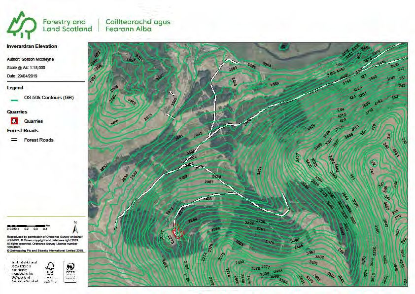
8.2 Physical site factors
8.2.1 Geology, soils and landform
Crianlarich is set at the junction of Glen Fillan/Glen Dochart and Glen Falloch in a
landscape dominated by the high mountains of Benmore and Stob Binean. These
rise to elevations of over 1100m directly from the valley bottom at about 150m.
The elevation within the plan area varies from 160m to 730m. Aspect is
generally northerly and the steep slopes mean there is little insolation in winter.
Upper slopes are steep, frequently in excess of 40% and there are many
examples of exposed rock faces. At lower elevations there are more extensive
areas of flatter ground, especially in the western part of Inverardran. Valley
floors tend to be narrow and filled with hummocky moraines.
The solid geology is dominated by fine grained metamorphosed sedimentary
rocks with low base status. These are overlain by a variable depth of glacial
material of variable texture. There is frequent induration at depth. This material
shows signs of instability in places and parts of both Inverardran and Benmore
were the subjects of geotechnical appraisals to assess slope stability and risk
(STAR). There are several examples of small landslips along burn sides and
there is some risk of debris flow and rock fall in places. Only Benmore has a
detailed soil survey and this indicates that peaty gley and surface water gley
dominate the lower slopes. Brown earths occur on steeper slopes but these are
likely to be of low base status and tending towards podsolization. Deep peat, of
34 |CRIANLARICH |STEPHEN MURPHY | |25th November 2019LMP Area Land Management Plan 2020-2030
variable nutrient status occurs in the western part of Inverardran, flatter
benches on hillsides and higher moorland.
8.2.2 Water
The area is drained by several large burns most of which drain into the Tay river
system. Burns in the every south western part of Inverardran drain south via
Glen Falloch. The burns are steep and occasionally incised and can rise quickly
during high rainfall events. SEPA flood risk maps indicate that there is high risk
of flooding within short distances of burns but more extensive risk areas are
restricted to flatter ground in Glen Dochart. There will be some potential for
erosion and resulting sedimentation downstream. There are renewable hydro
schemes on the Caorach Burn which runs through the Benmore section and in
Benmore Glen which borders Inverardran. There are several private water
supplies in the block and an important public supply point on the Allt Coire
Ardrain. All of the area falls within drinking water catchment areas (DWPAs) of
which the latter is at most risk from forestry activity.
8.2.3 Climate
Using the measures of warmth and wetness defined in the Ecological Site
Classification (ESC, see Forestry Commission Bulletin 124) the Crianlarich LMP
area is categorized as cool and wet becoming increasingly cold at higher
elevations where small areas are considered sub-alpine. Average annual rainfall
is in the region of 1450mm, about 60% of which falls between October and
March. The lower parts of the glens are considered sheltered, but exposure
increases rapidly becoming severely exposed on open hillsides above 400m.
8.2.4 Future climate
Predicting the impact of future climate change presents one of the biggest
challenges in forest planning. Analysis carried out by Forest Research indicates
an overall increase in average temperatures with warmer summers and milder
winters. There will be regional variation in the future rainfall pattern and
distribution, with a predicted decrease in summer rainfall in the east but a
predicted increase in the west of the country. This will lead to more frequent
drought in the east but a reduction in moisture deficit in the west.
There is less confidence in predicting changes in other climatic parameters such
as windiness and extreme winter cold or summer heat. However, there is a
general belief that the number of frost days will decrease and that the incidence
and severity of extreme events (e.g. gales and heavy rain) will increase.
Data for the LMP area suggest an increase in accumulated temperature of over
50% by 2050, compared to baseline 1960 – 1990 data, and about 75% by 2080.
Relative increase is even greater at higher elevations and all parts of the forest
are predicted to be classed as warm as early as 2050. Annual rainfall is
predicted to remain more or less the same, a decrease in summer rainfall being
compensated by a similar increase in winter. Despite the decrease in summer
rainfall moisture deficit is predicted to also decrease. The impact of these
changes on soil properties is uncertain. Potentially there could be an increase in
35 |CRIANLARICH |STEPHEN MURPHY | |25th November 2019You can also read