PUKEKOHE
AREA PLAN
MAHERE A-ROHE O PUKEKOHE
OCTOBER 2014
←
→
Page content transcription
If your browser does not render page correctly, please read the page content below
PUKEKOHE AREA PLAN MAHERE A-ROHE O PUKEKOHE OCTOBER 2014
HE MIHI                                                                                   FOREWORD
    Tēnā kia hoea e au toku waka mā ngā tai mihi o ata                                        It has been a wonderfully thought provoking and collaborative experience bringing
    e uru ake ai au mā te awa o Tāmaki                                                        together this plan. I want to acknowledge the effort and input from the wider
    ki te ūnga o Tainui waka i Ōtāhuhu.                                                       Pukekohe community, council staff and past and present Local Board members and
    I reira ka toia aku mihi ki te uru ki te Pūkaki-Tapu-a-Poutūkeka,                         also the former Franklin District Council who had laid such a great platform with the
    i reira ko te Pā i Māngere.                                                               District Growth Strategy.
    E hoe aku mihi mā te Mānukanuka a Hoturoa
    ki te kūrae o te Kūiti o Āwhitu.
                                                                                              Collectively we have considered what we want Pukekohe to look like in the future,
    I kona ka rere taku hāere mā te ākau ki te puaha o Waikato,
                                                                                              mapping out the types of development, zones and infrastructure needed to retain
    te awa tukukiri o ngā tūpuna, Waikato Taniwharau, he piko he taniwha.
                                                                                              this area as one of the absolute gems in Auckland’s crown.
    Ka hīkoi anō aku mihi mā te taha whakararo
    mā Maioro ki Waiuku ki Mātukutureia
    kei kona ko ngā Pā ō Tahuna me Reretewhioi.                                               Our thinking was based on a set of principles which meant we could treat ideas
    Ka aro whakarunga au kia tau atu ki Pukekohe.                                             and proposals fairly and equally and I sincerely believe we have a plan that clearly
    Ka tahuri te haere a taku reo ki te ao ō te tonga e whāriki atu rā mā runga i ngā hiwi,   reflects what we as a community have said through the many, many hours of
    kia taka atu au ki Te Paina, ki te Pou o Mangatāwhiri.                                    meetings, drop in sessions and discussions. The engagement for this plan has been
    Mātika tonu aku mihi ki a koe Kaiaua                                                      incredibly invigorating and done in a way not normally seen with council plans.
    te whākana atu rā ō whatu mā Tīkapa Moana ki te maunga tapu o Moehau.
    Ka kauhoetia e aku kōrero te moana ki Maraetai                                            I believe this plan achieves many things including protecting or safeguarding the
    kia hoki ake au ki uta ki Ōhuiarangi, heteri mō Pakuranga.                                things that you have told us are special – our rural identity and related industries,
    I reira ka hoki whakaroto ake anō au i te awa o Tāmaki                                    our natural and built environments and our wonderful spirit and sense of identity.
    ma te taha whakarunga ki te Puke o Taramainuku, kei kona kō Ōtara.
    Katahi au ka toro atu ki te Manurewa a Tamapohore,                                        Hopefully this plan will be a legacy for all of those who have contributed and a
    kia whakatau aku mihi mutunga ki runga o Pukekiwiriki                                     blueprint for Pukekohe so that coming generations will be able to enjoy a well laid
    kei raro kō Papakura ki kona au ka whakatau.                                              out and accessible town, and will think that we didn’t do too bad a job.

    Let this vessel that carries my greetings                                                 Andy Baker
    travel by way of the Tāmaki River                                                         Chair
    to the landing place of Tainui canoe at Ōtāhuhu.                                          Franklin Local Board
    There, let my salutations be borne across the isthmus to the Pūkaki lagoon
    and the community of Māngere.
    Paddling the Manukau Harbour
    we follow the Āwhitu Peninsula to the headland.
    From there we fly down coast to the Waikato river mouth,
    sacred waters of our forebears.
    Coming ashore on the Northern side
    at Maioro we head inland to Waiuku and Mātukutureia,
    there too is the Pā at Tāhuna and Reretewhioi.
    Heading southward I come to Pukekohe.
    My words turn to follow the ancient ridgelines along the Southern boundary,
    dropping down into Mercer and Te Pou o Mangatāwhiri.
    My greetings reach you at Kaiaua
    who gaze across Tīkapa Moana to the sacred mountain, Moehau.
    Taking to the sea, my remarks travel to Maraetai
    and then to Ōhuiarangi, sentinel to Pakuranga.
    There we follow again the Tāmaki River
    to Te Puke o Taramainuku, Ōtara resides there.
    From here I reach for Manurewa
    until my greetings come to rest on Pukekiwiriki
    below lies Papakura and there I rest.                                                     Franklin Local Board. Left to right: Jill Naysmith (Deputy Chair), Murray Kay, Sarah Higgins,
                                                                                              Brendon Crompton, Andy Baker (Chair), Malcolm Bell, Lyn Murphy, Alan Cole, Angela Fulljames.

i                                                                                                                                                                                             ii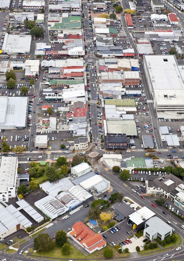
CONTENTS       Part A: Purpose and context                                  01
      Tatai korero
                               Purpose of the Pukekohe Area Plan                  01

                               Local and strategic context                        03

                     Part B: Key moves and outcomes                               11
                               Key moves and outcomes of the Pukekohe Area Plan   11

                          1.   Economic and community development outcomes        15

                          2. Transport and network infrastructure outcomes        19

                          3. Natural environment, open space, heritage            23
                               and character outcomes

                          4. Growth outcomes                                      27

                     Part C: Implementation                                       31
                               Implementing the area plan                         31

                               Prioritisation schedule                            33

                               Glossary                                           37

iii                                                                                    iv
PART A: PURPOSE AND CONTEXT
PURPOSE OF THE PUKEKOHE A REA PLAN
TE TAKE MO TE MAHERE A-ROHE O PUKEKOHE
MAYOR’S VISION
A 30-year vision for Pukekohe Why Pukekohe? What the area plan will do LOCAL BOARD
AUCKLAND PLAN
PLANS
The Pukekohe Area Plan outlines how While most other area plans cover a Area plans are one tool in Auckland
Pukekohe is envisaged to grow and full local board area, the area plan for Council’s strategic planning framework
MONITORING & EVALUATION
change over the next 30 years. It sets Pukekohe has provided for a detailed (Figure 1) that show how the Auckland AREA CORE FINANCIAL
LONG TERM PLAN
out desired outcomes and the actions response to the growth directions of Plan (its outcomes, proposed changes
UNITARY PLAN
PLANS STRATEGIES STRATEGIES
that will help to achieve them. the Auckland Plan, which identifies and strategic directions) can be
Pukekohe as a satellite town. delivered at a local level (Figure 2).
The plan will assist in achieving the ASSET
outcomes for Auckland and Pukekohe In addition, development of the area An area plan provides the next PRECINCT / POLICIES MANAGEMENT
that are set out in the Auckland Plan, plan allowed the Franklin Local Board CENTRE PLANS & PLANS PLANS / LOCAL BOARD
level of detail from the Auckland ACTIVITY PLANS
the Franklin Local Board Plan and the to provide direction on the zoning AGREEMENTS
Plan in identifying the form and
vision for Pukekohe. and rural urban boundary that has function of land uses and supporting
now been included in the Proposed infrastructure required over the next
Auckland Unitary Plan for the OTHER STAKEHOLDERS’ Figure 1:
30 years. AUCKLAND COUNCIL IMPLEMENTATION PLANS
Pukekohe area. IMPLEMENTATION PLANS Auckland Council’s strategic planning
Area plans are non-statutory framework
Auckland Plan The Pukekohe Area Plan covers the documents, but set out how other
Vision existing urban zoned area of Pukekohe, tools such as the unitary plan, local
and the area zoned Future Urban Zone board plan, long-term plan and other
To become the world’s in the Proposed Auckland Unitary Plan. council strategies can deliver the
most liveable city. This includes Pukekohe, Paerata to the actions of the area plan. An area plan
north and Buckland to the south. does not provide a street or site level
Pukekohe of detail, but indicates areas where
Vision this detail should be investigated.
Pukekohe will be a vibrant The outcomes in an area plan include
and dynamic satellite those that the council and its various
town offering a range of departments may deliver and those
employment and residential that council-controlled organisations
opportunities, with excellent (CCOs) can directly support. They
transport connections, also include outcomes that might be
Figure 2: Three levels of planning -
infrastructure, open space achieved by influencing the activities
Region wide (the Auckland Plan),
and recreation facilities, and of or forming close partnerships with
other parties such as government Sub-regional (area plans), and
a thriving local economy.
agencies, private landowners and Local (centre plans and structure plans)
community organisations.
1 2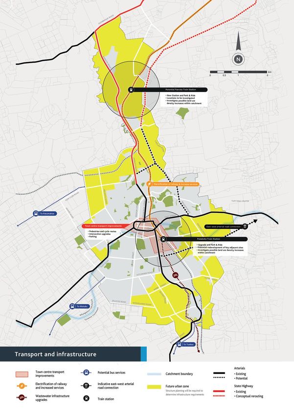
THE LOCAL & STRATEGIC CONTEXT TE ARONGA RAUTAKI MO TE TAKIWA AKE
Pukekohe’s community, Community Economy Environment Built environment & infrastructure
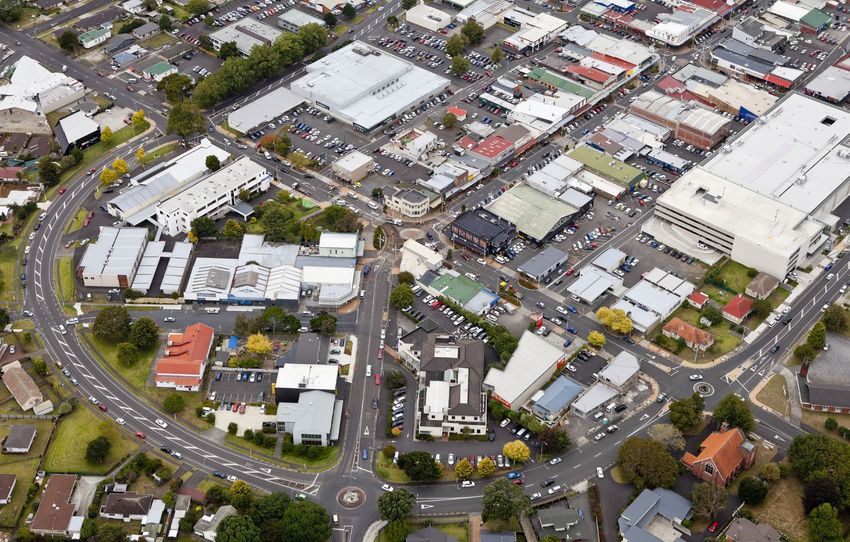
economy and environment Pukekohe is the largest settlement Pukekohe developed as a rural service The eastern side of Pukekohe is Pukekohe is located on the North The Pukekohe Park raceway, used for
in the Franklin Local Board Area. In town and centre of horticultural characterised by rolling country with Island Main Trunk railway line and motor racing and horse racing, and
2013, Pukekohe had approximately production being within an area with a number of volcanic features. These is connected to Auckland by State the Pukekohe Showgrounds, used for
Pukekohe is located approximately 21,000 residents, 32 per cent of the some of New Zealand’s most elite include Pukekohe Hill, the Pukekohe Highway 22 and Pukekohe East Road, the annual A & P show, and other
50km south of central Auckland, population of the Franklin Local Board soils and prime agricultural land. East Tuff Ring and Paerata Bluff. The which connect with the Southern community activities, are located on
Area. volcanic features are of particular Motorway to Auckland. the outskirts of the Pukekohe urban
south of the Manukau Harbour and Pukekohe has 7600 jobs, with retail,
significance to iwi. Pukekohe’s west is area. The Ecolight Stadium, Bledisloe
north of the Waikato River. The Pukekohe has more people in the education, health care, professional
more gently contoured and contains a
The Pukekohe town centre is focused
Park, Rosa Birch Park and the Franklin
youngest and oldest age groups services and wholesale trade being around the main shopping street King
name ‘Pukekohe’ means ‘hill of compared with Auckland as a whole. the largest employment sectors in
significant area of elite soils used for
Street with a number of intersecting
Trotting Club are well used local sports
market gardening. and recreation facilities.
the kohekohe’. Mana whenua iwi Pukekohe. shopping streets such as Edinburgh,
The ethnic profile of Pukekohe is
with interests in the area include predominantly New Zealand European
Pukekohe’s freshwater environment Hall and Seddon streets.
is characterised by two stream
Ngati Te Ata, Ngati Tamaoho, Te (69%), with the next largest ethnic
catchments, the Whangapouri Steam
The historic town centre is bounded
Akitai Waiohua, Ngati Paoa and group being Māori (18%), and then by the Pukekohe ring road. A more
from the north and the Tutaenui
Indian (6%). Pukekohe has more recently established area of large
Ngai Tai ki Tamaki. European and Māori than the average
stream from the south. The tributaries
format retail has developed to
of these streams flow throughout the
for Auckland as a whole, and fewer the south of the town centre, on
existing town and the Future Urban
Asian and Pacific peoples. Manukau Road. Paerata and Buckland
Zone areas.
feature local shops and community
Small areas of native bush are facilities which service the small local
protected within and around Pukekohe settlements.
on both public and private land as
Significant Ecological Areas (SEAs).
Public SEAs include Rooseville Park
and Paerata Scenic Reserve. Most SEAs
are located on private land within the
Future Urban Zone.
3 4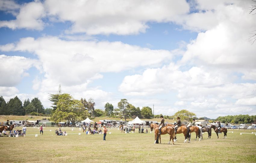
? aR
o a
Le
rtt
r ak
Bu
Ka
Mixed rural
Cha
rle s
production ?
Roa
Gellert Road
Bush
d
D.1 DEVELOPMENT living
STRATEGY MAP Rural Helensville
Hauraki
production
ay
dW
d
e
(AUCKLAND WIDE)
Dorsy
R oa
riv
eD
Gulf G eorg
Sim
est
Ern
Urban development Rural ad
production G l e nb r o
ok
Ro
Country
Solita ir e La n e
Most change
living Albany
Significant change Riverhead
Patrick Lane
? Ne
ed
ha
Moderate change
m
Ro
Kumeū /
ad
Some change Huapai ? ? Public open space Oneroa Rural
Takapuna island
Least change
ad
Westgate / City Centre at a
Roa
d
Road
Couls
ton Ro
ad
Kern
Country Massey & Fringe
h im
h Ro
! Metropolitan centre
Tu
Waitematā Ostr ic h
Os tric
Fa
rm
living North Harbour
Ro
a
Tuhi m a t Road
H
i ng Dri ve
a
Beachlands
d
Norfo lk K
ad
Satellite town
Ro
/ Pine
B us h
Newmarket Harbour
j
k Rural and coastal town Bush
Ca
pe
Henderson Rural
ill
H
living
Ro
a
?
d
coastal
Major business areas
Waitakere New Lynn
Ranges Sylvia
Pae rata
Two big initiatives:
Schla
ad
er Ro
Public Park llagh
epfer
Road
Hu Ga
City Centre & Fringe / The Southern Initiative Botany
Beatty
n
Country
Road
open
ter
Heights
Rural
Road
R
oad
living
Road
Future urban business areas (pipeline) space coastal
Helvetia
Pa
Sc
d
rd R o a
h
e ra
Rutherfo
Manukau
lae
Roa
ta
Future urban residential areas (operative)
pfe
d
Ro
rR
Ru
ad
oa
nc i
d
d
ma
a
Ro
Mixed rural
n R oad
lub
Future urban residential areas (pipeline)
nC
Manukau Gu
Ad
Harbour production
a
Th
ms
S o uth
Ro
? Greenfield areas for investigation
P u kek
e
ad
Mor ga
e rn In it
oh e n
E as t Ro a
Roa d d
ia ti Ea
s t Stre
et
Hunua
S tr e e t
ve
Ranges
Ferry routes
Ha
W
es
rt R
le y
Edi n bu rgh
Ad
ad
Public
S t reet
oa
Papakura Ro
am
d
nin
sR
Cro
Existing rail network
oa
open
dS
t
Go
Man uka
ee Ha r ris St r e e t
S tr
ldin
Rural
ou
Hunua ad ad st
th
Ro o e
gR
space
tR W
ett on
oa
rb
Ranges
u Roa
lm
Proposed rail network
Co
Ru
Be
coastal
d
ss
Tasman
ell
d
Ro
Je
Pa
ad
d
n
tum
Sea
a
kin
Ro
Rapid Transit Network (RTN) ? ?
ah
e n
Ro
Ed
oe
ad
Ro
D
om
ad
d
Rural
oa
ain
R
R
ni
Baseline 2010 Metropolitan Urban Limit
Stu
oa
Sta
d
oa Pu
?
d
ad
art
â â â â â â â â â ââ
production
tio
R
ion Ro
n
Ro
Ro
Un k
ad
c Road
ad
llo
Do
R
Logan
Po
ow
ug
Bush living
le
la
s
s
Green Lane
R
Ro
oa
Yat es
Road
Fo
ad
d
? ?
y
Ro
ad
ad
Ro d
Country living
rs oa
ge R
Ro ku
a iu
W eet
? ?
Str
Qu
bb
Ca
Mixed rural production
We
arr
lcu
d
yR
oa
tta
R
? Pukekohe
R
oa
ke
oa
d
Bla
Road
d
Major public open space
Street
Jellicoe Road
Anzac
Tu
ak
Woodland
s Road
Upper Queen
au
Roa
Harris
Rural coastal
Hill
d
Buckville Road
To
ville Ro
pR
Jam
ad
d
Waiuku
oa
Ro
oa
ieso
d
n
Att
R
ad
leto
Rural island
ew
nd
d
n
a
Mid l
e ll
ck
Roa
Ro
oa d Ray Wright Road u
yR B
ad
d
Bayl
ad
Rural production Ro
Ro ad
Tr am le y
ze w Ro
ad
way Burro
oad
Aka
Da
Roa
d n e
nR
Aka
in a L a
Defence land Nand
Fulto
Regional Boundary (land) The Auckland Plan Development Strategy Map Proposed Auckland Unitary Plan zoning for Pukekohe
This map/plan is illustrative only and all information should be independently verified
on site before taking any action.Copyright Auckland Council. Land Parcel Boundary
Regional Boundary (water)
information from LINZ (Crown Copyright Reserved).
Strategic<
=
Whilst due care has been taken, Auckland Council gives no warranty as to the
accuracy and completeness of any information on this map/plan and accepts no
liability for any error, omission or use of the information.
Auckland Council GIS Data
context
Port
Height datum: Auckland 1946.
The Auckland Plan
´
1:25,000
Other strategic action plans and The Unitary Plan Previous strategies undertaken by
o International
The PukekoheArea
Area
Airport
The Auckland Plan is the 30 year
Plantoisthe Eastern Access Agreement
subject
The Area Plan seeks to deliver the Plan Created: 11/12/13
strategies
click here to view Unitary Plan Legend
http://intermaps.aklc.govt.nz/plans/UnitaryPlanLegend.pdf
Franklin District Council
_
^ including Pūkaki Marae, AC and AIAL.strategy to make Auckland the Auckland Plan at a local level. It sets out 0 5 10 Km The Unitary Plan, developed under
guided by a number of Auckland world’s most liveable city. Auckland a high level strategy for the staging and Auckland Council has developed various the Resource Management Act The Pukekohe Area Plan builds on the
Last updated: 18 June 2012 9:30am zoning of future growth areas around other strategic action plans and strategies 1991, replaces the existing Auckland background research and strategic
Council strategic documents and is anticipated to grow by 1 million
the existing town, what transport and to set out how the Auckland Plan Regional Policy Statement and work done for the 2003 Pukekohe
people over the next 30 years. The
establishes an action plan to Auckland Plan describes the kind of infrastructure is required to enable this outcomes can be achieved over the next multiple district and regional plans to Town Plan, which is an earlier 30-year
implement initiatives. place Aucklanders have said they growth, how the local economy can 10 years. These include: create one planning rulebook for all of vision for Pukekohe, and the 2007
be grown, how living standards can be • The Housing Action Plan Auckland. It sets out what people can Franklin District Growth Strategy.
want, and outlines what is needed to
improved for the people of Pukekohe and cannot do with their land, through
achieve it. • The Franklin Local Economic Development The Franklin District Growth Strategy
and how the environment and places of Action Plan zoning rules and requirements.
was the policy for managing the
The Auckland Plan sets out six significance can be protected. • Sport and Recreation Strategic Action Plan Early engagement for the Pukekohe former Franklin District’s growth
‘transformational shifts’ and also a
Auckland’s Economic Development • Parks and Open Space Strategic Action Plan Area Plan in 2013 resulted in through to 2051 and identified areas
Development Strategy, which sets out
Strategy • The Auckland Biodiversity Strategy refinements to the draft Unitary around Pukekohe to cater for future
how Auckland will accommodate the
Plan to better reflect how we want population growth.
expected population growth. To achieve the Auckland Plan vision of the • The Māori Plan for Tāmaki Makaurau
Pukekohe to grow. You can read
world’s most liveable city, the economic These documents have informed
What does this mean for Pukekohe? The Pukekohe Area Plan supports these more about this in the ‘Engagement
development strategy sets out how the the key moves and outcomes in the
action plans and strategies by identifying and feedback’ chapter. The ‘Growth
Pukekohe is identified in the Auckland economy will deliver opportunity and Pukekohe Area Plan.
and prioritising outcomes to be achieved outcomes’ chapter identifies future
Plan Development Strategy as a prosperity for the region. It sets out at a local level. The Pukekohe Area Plan growth areas for Pukekohe, and
priority satellite town, anticipated to priorities and a specific set of actions for Franklin Local Board Plan
should be read and implemented in suggests possible future Unitary Plan
grow to a population of 50,000 people the next 10 years, and how these will be conjunction with these other plans and zones that should apply to these areas. The Franklin Local Board Plan sets the
by 2040. This will more than double measured. strategies. framework that guides the board’s
Pukekohe’s current population of The Proposed Auckland Unitary Plan
decisions on local activities, and
21,000 people. zoning for Pukekohe is shown on the
the board’s input into the regional
map above.
activities and decisions of the
Auckland Council.
The Area Plan team and the Franklin
Local Board team have worked closely
together to ensure that the Area Plan
and the 2014 Local Board Plan align
with each other.
5 6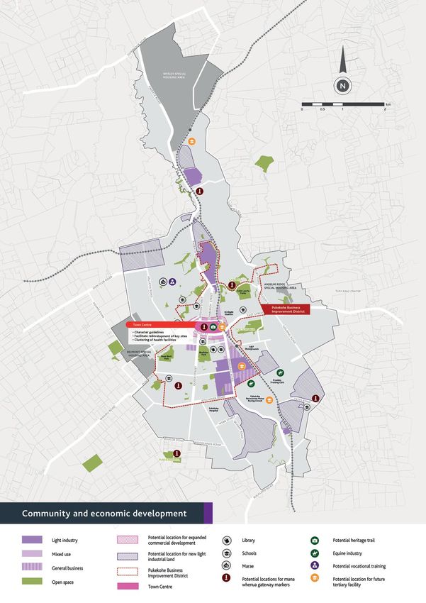
ENGAGEMENT& FEEDBACK
TE TUHONOHONO ME TE WHAKAHOKI KORERO

                                                                                    Outcomes of initial engagement
Engagement with iwi and all              Initial engagement considered the
                                         following five key questions:
stakeholders within the local                                                       The initial area plan engagement
                                         1. What makes Pukekohe an                  established the following eight high
community is a critical part                                                        level principles to guide thinking about
                                            attractive/desirable place to live?
of the area plan process. Our                                                       Pukekohe’s future and also helped to
                                         2. What influencers are there on
approach built on that undertaken           growth – what areas should be
                                                                                    shape the development of the (local)
                                                                                    Unitary Plan zones, including the areas
for the preparation of the                  protected from growth, where can        to be included in the Rural Urban
Auckland Plan, Unitary Plan and             growth be accommodated and              Boundary (RUB) and Future Urban
                                            which areas should be prioritised
Franklin Local Board Plan.                  for growth?
                                                                                    Zone.
                                                                                    • Pukekohe is not a dormitory suburb
                                         3. Land uses – where should we               of Metropolitan Auckland
Initial engagement                          accommodate new housing and
                                            employment areas and new                • Pukekohe is to remain a separate                                                                                             2013 and 2014 public engagement
We sought to find out from the              community facilities?                     and satellite town – this is our
community their views on the issues                                                   point of difference
facing Pukekohe. The engagement          4. How can we make the town centre                                                    Establishing the Key Moves
                                            a great place to live work and visit?   • Future employment focus should
included evening events for invited                                                                                                                                     Engagement with iwi and local
                                                                                      relate to new growth areas e.g.          Feedback from the initial consultation
stakeholders, public market events and   5. What is missing from Pukekohe?                                                                                              stakeholders to discuss the preliminary
                                                                                      south east Pukekohe and Paerata          was used to draft the Key Moves,
open day events.                                                                                                                                                        Key Moves was of real benefit to their
                                         Feedback was generated in a number                                                    which we then sought community
                                                                                    • Support growth around one town                                                    refinement and to the development
Meetings with iwi, government,           of ways. Ninety-six questionnaires                                                    feedback on. Flyers describing the Key
                                                                                      centre and a number of local                                                      of the area plan as a whole. Feedback
council controlled organisations,        were completed and returned to the                                                    Moves were provided to iwi and all
                                                                                      centres                                                                           was particularly useful for the early
interested individuals, land owner       council. Feedback was also provided                                                   stakeholders in March 2014 together
groups and the Franklin Youth                                                       • Pukekohe’s western elite soils           with feedback forms. Drop in sessions    consideration of possible urban zones
                                         by way of comments provided at
Advisory Board were also held.                                                        should be protected from growth          were held to enable attendees to         within the Future Urban Zone, which
                                         meetings, workshops and through
Through these events, approximately                                                                                            discuss the Key Moves with the area      is discussed in the ‘Growth outcomes’
                                         the use of interactive stations at         • Pukekohe needs a self-sustaining
600 people were consulted with over                                                                                            plan team and to invite feedback.        chapter.
                                         engagement events.                           employment base to offer its
June and July 2013.
                                                                                      residents job choice                     The team also took the opportunity
                                                                                                                               to re-engage with the youth advisory     July finalisation
                                                                                    • Respect cultural values and
                                                                                                                               board – to explain the Key Moves and     A final drop in session for local
                                                                                      landscapes
                                                                                                                               seek feedback. Thirty-four feedback      stakeholders was held in Pukekohe in
                                                                                    • Include Waikato as part of the           forms were completed and returned        late July 2014. Feedback received from
                                                                                      growth and infrastructure planning       to the council. Feedback was also in     this was used in the finalisation of the
                                                                                                                               provided by way of comments at the       area plan.
                                                                                                                               drop in sessions.
                                                                                    Feedback on all key issues has been
                                                                                    used to inform the development of
                                                                                    the area plan. It also supported the
                                                                                    Local Board feedback/input on the
                                                                                    Draft Unitary Plan.

7                                                                                                                                                                                                                                                8
Engagement day on Pukekohe Hill March 2014 drop-in session
Mana whenua engagement A particular focus was that of At a workshop held at Ngā Hau e Wha People liked Pukekohe’s rural outlook People were supportive of structure
archaeological items and places of Marae, attendees suggested enhancing The feedback received and feel, that it is a country town, planning being progressed towards
Mana whenua have an ongoing
natural heritage significance, mapped and improving key local streams and has a sense of community, has a ‘live’ (or ‘urban’) zones for new
connection with the Pukekohe area Community feedback through the
and scheduled heritage places within increasing the local light industrial great residential and rural mix, and businesses, public open space and
and their presence, identity and
history is marked in the land, the
the Unitary Plan as well as areas that land supply to provide more jobs for development of the area plan has that “Everything you need is here”. residential growth:
could potentially be protected and whanau. Additionally, land close to the
hills and the waters of the study
enhanced. marae was proposed for a vocational
been wide ranging and includes
area. Mana whenua have their own People also said that Pukekohe “Council and the Local Board [to] ensure as
training facility, papakainga housing, the following comments. a priority that adequate funding is available
aspirations for the area. These include significant ridgelines “has Lots of Room for development go for it!
a multi-purpose sports park and aged in the Long Term Plan to ensure sufficient
and streams traditionally used by Go for it!”
In developing this area plan, care living. resources are provided to carry out the
local iwi for gathering kai and for “is a good place to bring your family up”
the council team engaged with structure planning necessary to facilitate
spiritual purposes. At a hui held at the Part of the intent of this area plan is
representatives of Ngāti Tamaoho, future rezoning and land release including
summit of Pukekohe Hill, local features to build a responsive and mutually and that they enjoyed the
Ngāti Te Ata, Te Akitai Waiohua, any necessary infrastructure upgrades.”
of significance were identified by supported future for Pukekohe. The
the Huakina Development Trust “Multicultural diversity in our township”
kaumatua and mapped by the council linkages and ongoing relationship
and representatives from Ngā Hau “I really like the suggestions for Pukekohe
team. This information has helped to forged with mana whenua through
e Wha Marae at a number of hui. People were supportive of transport Hill and Paerata Bluff, can Doctor’s Hill be
shape this area plan. the area plan process will be to the
Engagement identified the mana improvements proposed and incorporated in some way?”
benefit of Māori, the wider Pukekohe expanding local tertiary education
whenua issues, values and aspirations
community and the environment facilities:
for the Pukekohe area. “there is an urgent need for more business
as a whole moving forward into
implementation. land and Council should implement the
“Strongly support major transport hub at
zoning as quickly as possible”
Pukekohe station”
“Increase industrial land (x2 or x3) and
“We need and support a significant Tertiary
locate near water source to allow larger
Facility, e.g. a university or polytechnic
industries to relocate to the area. This will
located in close proximity to the Train Station
provide for additional local jobs and avoid
and Pukekohe Town Centre. With only two
the need for workers to commute via the
agricultural colleges in NZ there is significant
motorway”
opportunity to develop a college to support
local horticulture in conjunction with say
Agriculture NZ”
9 10
THE AUCKLAND PLAN’S VISION – THE WORLD’S MOST LIVEABLE CITY – TE PAI ME TE WHAI RAWA O TAMAKI
PART B: KEY MOVES AND OUTCOMES SIX TRANSFORMATIONAL SHIFTS TO ACHIEVE THE AUCKLAND PLAN’S VISION
KEY MOVES OF THE
Dramatically Strongly commit Move to Radically improve Substantially Significantly
accelerate the to environmental outstanding the quality of raise the living lift Māori social
prospects of action and green public transport urban living standards for all and economic
Auckland’s growth within one Aucklanders and wellbeing
PUKEKOHE AREA PLAN
children and network focus on those
young people most in need
PUKEKOHE AREA PLAN
Pukekohe will be a vibrant and dynamic satellite town offering a range of employment and residential opportunities, excellent
NGA KOKIRINGA MATUA MO PUKEKOHE / KO NGA HUA ME NGA MEA HEI MAHI transport connections and infrastructure, open space and recreation facilities and a thriving local economy.
KEY MOVES
1 2 3
Electrification of the rail line
Provide for growth in the Enable at least 100ha of from Papakura to Pukekohe
The Pukekohe Area Plan will assist Future Urban Zone new business land (with potential station at
with the delivery of the vision for Paerata)
Auckland through its key moves Auckland’s vision in the Auckland Plan is to become the Residential land is required to Business land is required to provide for Faster and more frequent services and a
and outcomes: accommodate the doubling of Pukekohe’s
‘World’s Most Liveable City’ – Te pai me te whai rawa ō Tāmaki. population to 50,000 people over the
local employment – providing 9000 new future station at Paerata will encourage
jobs. This includes the identification greater use of the railway, provide
next 30 years. of light industrial land in the Future transport choices for people to travel
Urban Zone, and redevelopment of land to Papakura and further north, and
around the town centre periphery for encourage people to visit Pukekohe.
commercial/office purposes.
The six transformational shifts outlined in the Auckland Plan
to achieve Auckland’s vision have guided the development of the
Pukekohe Area Plan.
The Pukekohe Area Plan shows how the Auckland Plan
4 Improve accessibility and
connectivity throughout
Pukekohe and Paerata
Growth provides an opportunity to
create connections, such as an east–west
5 Support land development
around Pukekohe Train
Station
Development of the area surrounding
6 Investigate tertiary
education opportunities
Expanding the local tertiary education
the Pukekohe Train Station provides sector will bring benefits by retaining
will be put in place, at a local level, over the next 30 years. connection from Manukau Road to
an opportunity to maximise the and attracting young people, improving
Pukekohe East Road. Walking and cycle
routes connecting the town centre, train site’s location and promote transport local education and supporting
station and Manukau Road will increase the choices – through more intensive uses local industries such as motorsport,
walkability of Pukekohe and access to public such as tertiary education or a mix of agriculture, horticulture and the equine
transport. commercial and residential. industry.
Nine key moves are identified in the area plan as
opportunities to transform Pukekohe.
7 8 9
Maintain and improve
Protect and enjoy Pukekohe Pukekohe’s environmental Develop Town Centre
Hill, Paerata Bluff and quality and special ecological Character Guidelines
Pukekohe East Tuff Ring areas, including the Tutaenui
and Whangapouri streams
Four chapters ‘Economic and community development outcomes’,
These unique natural features are The Pukekohe town centre – and in particular
‘Transport and network infrastructure outcomes’, ‘Natural environment, important to iwi and the Pukekohe Development of the Future Urban Zone King Street – benefits from the detailing,
open space, heritage and character outcomes’ and ‘Growth outcomes’ community – there is a need to discuss provides an opportunity to connect scale and form of its heritage buildings.
provide detail on all the key moves, and provide additional outcomes as with the respective owners how best existing reserves and create new reserves Guidelines on new development and on the
well as stating the actions that will assist in achieving them. to achieve an increase in protection along the many streams in the Pukekohe maintenance and restoration of existing
and/or public access to them, and their area. buildings will assist in retaining this unique
enjoyment. identifying character.
The actions to achieve this broader list of outcomes, in the form
of projects, programmes, studies and further work are listed in the FURTHER OUTCOMES, AND THE ACTIONS TO ACHIEVE THEM ARE ADDRESSED IN FOUR CHAPTERS:
Prioritisation Schedule, including whether they are currently funded, or
whether they are future projects that are currently unfunded. Economic and community Transport and network Natural environment, Growth
development infrastructure heritage and character
PRIORITISATION SCHEDULE
11 12
KEY MOVES & OUTCOMES
THE 9 KEY MOVES ARE:
             Single Housing

         Mixed Housing Suburban
                                      Light Industrial
           Terraced Housing &
           Apartment Buildings

          Special Housing Area

     1   Provide for growth       2    Enable at least        3   Electrification of the rail line from Papakura to     4   Improve
         in the Future Urban           100ha of new               Pukekohe (with potential station at Paerata)              accessibility &
         Zone                          business land                                                                        connectivity
                                                                                                                            throughout
                                                                                                                            Pukekohe & Paerata

     5     Support land           6    Investigate            7   Protect and enjoy            8   Maintain             9   Develop Town
           development                 tertiary education         Pukekohe Hill,                   and improve              Centre Character
           around Pukekohe             opportunities              Paerata Bluff and                Pukekohe’s               Guidelines
           Train Station                                          Pukekohe East                    environmental
                                                                  Tuff Ring                        quality and
                                                                                                   special ecological
                                                                                                   areas, including
                                                                                                   the Tutaenui and
                                                                                                   Whangapouri
                                                                                                   streams

Further outcomes, and the actions to achieve them           • Economic and community development
are addressed in four chapters:                             • Transport and network infrastructure
                                                            • Natural environment, heritage and character
                                                            • Growth

13                                                                                                                                               14
1. ECONOMIC & COMMUNITY
DEVELOPMENT OUTCOMES This section identifies the outcomes needed to support improved employment opportunities, a thriving town centre, social
benefits and tertiary education opportunities for Pukekohe residents into the future. The outcomes will also help to improve
the wider community wellbeing and attract visitors, investment and expenditure to the area.
NGA HUA O NGA WHANAKETANGA MAHI OHAOHA A-HAPORI HOKI The community and economic development map overleaf illustrates how the outcomes fit within the Pukekohe area.
OUTCOME 1.1 OUTCOME 1.4 OUTCOME 1.5 OUTCOME 1.6 OUTCOME 1.7 OUTCOME 1.8
Grow Pukekohe’s 1.1.5 Promote equestrian 1.2.2 Enable structure 1.3.4 Develop culinary Pukekohe’s town centre Tertiary education Maori history, Pukekohe offers high Improve the education, 1.8.5 Encourage the
and related facilities in vitality is enhanced
economy and Pukekohe to support
planning and plan tourism opportunities facilities (including culture and identity quality, affordable health and safety of clustering of health facilities
provision of jobs to changes to facilitate by leverage of the local trades training) are is recognised and social infrastructure Pukekohe residents in the Pukekohe town
equestrian-based visitor the development of horticultural and food
match the anticipated attraction and industry approximately 15ha of producing sectors. ACTIONS expanded locally to promoted through and services that meet with a focus on those centre and on key public
transport routes by working
population growth growth. This includes the new commercial (mixed cater for Pukekohe’s improved access to community needs most in need with health providers,
1.4.1 Enhance the amenity
potential of Pukekohe use zoned) land during
1.3.5 Investigate the
and experience of the
anticipated population social and cultural landowners and developers.
potential for a local
ACTIONS becoming a regional the 2015 to 2025 period town centre through the growth infrastructure ACTIONS ACTIONS
training ground for harness horticultural industry 1.8.6 Work with the Wesley
and 15ha per decade from implementation of place
1.1.1 Provide for new light racing and associated ‘MOTAT’. 1.7.1 Undertake an 1.8.1 Work with the Special Housing Area
2025 through to 2044. Also
industrial and commercial activities. see discussion within the 1.3.6 In collaboration with
making initiatives and ACTIONS ACTIONS analysis to determine the Ministry of Education and applicant team to ensure
streetscape upgrades.
zoned land through ‘Growth outcomes’ chapter. the Franklin Historical 1.5.1 Undertake a feasibility 1.6.1 Support the community service needs other parties such as private that adequate space is
structure planning processes 1.4.2 Identify sites in the available for an integrated
(see discussion at Outcome
OUTCOME 1.2 Society develop a Pukekohe and site location study for development of Māori of Pukekohe residents aged providers to help ensure the
family health centre in the
Pukekohe town centre that 65 and older both now and early childhood education
1.2 below). OUTCOME 1.3 heritage trail following
have future development
expanded local tertiary economic and social
into the future. needs of the expanding Wesley Special Housing
Sufficient serviced completion of the Pukekohe education delivery. development initiatives in
Area.
heritage study. potential over time. Work Pukekohe consistent with Pukekohe population are
1.1.2 Support innovation business land, Tourism within with landowners and key 1.5.2 Progress liaison with 1.7.2 Undertake analyses of
met.
the Māori Plan.
that strengthens sectors in specifically light Pukekohe is developed 1.3.7 Advocate for stakeholders to facilitate universities, technical community facilities, where
which Pukekohe businesses industrial and and grown to maximise Pukekohe’s hosting (or the use of this land to institutes and private 1.6.2 Investigate a gaps in the provision of 1.8.2 Support key youth OUTCOME 1.9
have a competitive these have been identified and family support
advantage such as
commercial is available the area’s economic promoting maximised local provide more retail, office, providers to expand the Pukekohe Gateways
Pukekohe’s future sport
leverage) of future major provision of tertiary Celebration partnership in the 2014 Community organisations to build
horticulture, rural supply, to enable the growth potential business and community
Facilities Network Plan, a collective community and recreation needs
sporting events – events education facilities in project with mana whenua
food processing, automotive of local business such as the 2015 Under 20
space for the growing
Pukekohe. iwi and the Franklin Local particularly focusing on response to antisocial are provided for within
population.
and engineering, and employment in ACTIONS FIFA World Cup, 2015 ICC Board. youth. behaviour in Pukekohe. existing open spaces
motorsport, and the equine line with Pukekohe’s Cricket World Cup matches 1.4.3 Continue
and the Future Urban
1.3.1 Auckland Council 1.6.3 Investigate the 1.7.3 Determine the future 1.8.3 Liaise with the
industry. anticipated population and ATEED to facilitate and 2017 World Masters collaboration between
scope and scale of Pukekohe Pukekohe North Steering Zone
opportunity for a vocational
1.1.3 Leverage the Business growth through to 2044 and support the emerging Games. key community and
training facility near the Library, as indicated by the team to measure and
business organisations,
Improvement Districts Franklin Tourism Group to 2014 Libraries Facilities improve community
programme to support promote Pukekohe tourism.
schools the Franklin Local Ngā Hau e Wha marae.
Development Plan. capacity and social and
ACTIONS
the diverse economic ACTIONS Board, Auckland Council
economic outcomes within 1.9.1 Investigate the need
1.3.2 The development of a and Auckland Transport 1.7.4 Work with the Wesley
development potential of 1.2.1 Enable structure the Pukekohe North Area. for local recreation precincts
local tourism plan. to deliver town centre Special Housing Area
the area. planning and plan changes that provide for multiuse
initiatives through the applicant team to ensure 1.8.4 Establish a formal
1.1.4 Work with ATEED to facilitate the release of 1.3.3 Leverage off V8 forum of the Town Centre sport and recreation
land for social infrastructure partnership between the
to develop pathways approximately 30–35ha of events by way of cross Revitalisation Committee. facilities for existing and
needs is incorporated into Franklin Local Board and the
for Pukekohe food and new light industrial land promotional activities and future communities.
structure planning for Franklin Locality Leadership
beverage processors and during the 2015–2025 local events to capture a Facilities to be well serviced
Wesley. Group to monitor and
niche food producers to period. A further 30–35ha greater visitor spend. by public transport and
improve health and social
access the ‘FoodBowl’ is to be released per decade 1.7.5 Once the new Wesley routes for active modes of
wellbeing in Pukekohe.
and the Food Innovation from 2025 through to 2044. community is further transport.
network. established, undertake an
1.9.2 Upgrade existing
analysis of community
recreation infrastructure
needs and aspirations to
in accordance with Sports
refine how the social needs
Code Facility Plans and Park
of the community are to be
Development Plans.
catered for.
15 1617
2. TRANSPORT & NETWORK
INFRASTRUCTURE OUTCOMES
This section identifies the outcomes needed to help provide improved transport and infrastructure in Pukekohe. The
outcomes will also provide for efficient infrastructure provision as the Future Urban Zone is developed, as well as
maximise the opportunities that land use development around public transport facilities can bring.
NGA HUA O TE TUHONOHONO I NGA KAWENGA TANGATA. The transport and network infrastructure map overleaf illustrates how the outcomes fit within the Pukekohe area.
OUTCOME 2.1 OUTCOME 2.2 OUTCOME 2.3 OUTCOME 2.4 OUTCOME 2.5
Electrification from Papakura to Support land development around Transport and network utility Improved transport Improved local transport and
Pukekohe (with potential station Pukekohe Train Station infrastructure services are connections to Pukekohe access to the town centre
at Paerata) considered as part of structure
ACTIONS planning of new urban ACTIONS ACTIONS
ACTIONS 2.2.1 Upgrade Pukekohe Train Station
development 2.5.1 Investigate, through pedestrian 2.5.4 Investigate opportunities for a
2.4.1 Assess demand for bus services
2.1.1 Progress investigation towards the to include a permanent pedestrian over from the adjacent settlements of Waiuku, counts and pedestrian route analysis, network of cycle routes and facilities in
electrification of the railway between bridge, bus interchange, park and ride and ACTIONS Tuakau and Patumahoe to Pukekohe Train priority locations for new pedestrian Pukekohe, Paerata, and Buckland.
Papakura and Pukekohe. passenger facilities. Station, before and after electrification crossings on the town centre ‘ring road’ of
2.3.1 Complete the catchment Tobin Street, Stadium Drive, Wesley Street 2.5.5 Work with businesses to develop
2.2.2 Assess the availability of large, of the railway, in conjunction with the green travel plans for businesses and their
2.1.2 Advocate to Auckland Transport management plan modelling and flood and Massey Avenue.
undeveloped or partially developed sites Waikato Regional Council where relevant. employees, encouraging people to travel
for the provision of a more frequent train hazard assessment for the two Pukekohe
service, including weekend services. near the Pukekohe Train Station, which catchments of Whangapouri and Tutaenui, 2.4.2 Progress investigation for an 2.5.2 Investigate potential local traffic to work on public transport, by foot or by
could be redeveloped with a land use in order to identify solutions to stormwater east–west arterial road connection, from improvements at Manukau Road, Custom bike.
2.1.3 Investigate locations for a Paerata density, mix of uses and layout that is Street and Harris Street, to reduce
issues, including current flooding issues, and Manukau Road to Pukekohe East Road.
train station. supportive of greater use of the train congestion.
support variations to discharge consents.
station. 2.4.3 Through structure planning for
2.1.4 Investigate whether there should 2.5.3 Identification of and improvements
2.3.2 Complete the upgrade of the growth areas ensure growth north
be further increases in land use density 2.2.3 Investigate whether there should be to walking and cycling routes connecting
wastewater connection from Tuakau of Pukekohe and Paerata takes into
in Paerata to support the investment in a further increases in land use density within the town centre, train station and Manukau
through Buckland to south Pukekohe, consideration a potential rerouting of State
local train station. the train station catchment to support use Road shopping area, such as through the
enabling the southern area of Pukekohe as a Highway 22.
of the train station. possible area for the first stage of growth. provision of street trees, furniture, paving
and cycle facilities.
2.3.3 Complete upgrades to the Pukekohe
Wastewater Treatment Plant, to provide for
the expected population growth.
2.3.4 Through structure planning for
the Future Urban Zone areas, identify
proposed/conceptual primary and
secondary arterial roads and protect these
corridors for future use.
19 2021
3. NATURAL ENVIRONMENT, OPE N SPACE
HERITAGE & CHARACTER OUTC OMES This section identifies the environmental, heritage, open space and character outcomes needed to better
support and improve Pukekohe’s environment.
The natural environment, heritage and character map overleaf illustrates how the outcomes fit within the
NGA HUA O NGA TAKE TAIAO, TAONGA TUKU IHO, ME TE AHURU MOWAI Pukekohe area.
OUTCOME 3.1 3.1.4 Prioritise improvements to park 3.2.2 Recognise and support Mana whenua’s OUTCOME 3.3 OUTCOME 3.4 OUTCOME 3.5
infrastructure and the environment at the customary kaitiaki role by encouraging their
Protect and enjoy Pukekohe’s Pukekohe Hill reserve to enable appropriate leadership of environmental restoration
Identify, understand and reveal Pukekohe’s cultural heritage and A connected network of high
recreational use, a diversity of experiences, and management programmes for the
valued landscapes and natural and appreciation and enjoyment of its Whangapouri and Tutaenui streams (for Pukekohe’s built heritage culturally significant landscapes quality open spaces and recreation
features especially Pukekohe Hill, open space, views and natural, cultural and example – integrate this initiative into the are identified, celebrated and areas within Pukekohe’s new growth
Paerata Bluff and the Pukekohe geological settings. structure plan and subsequent subdivision
ACTIONS protected areas that connects to and builds
process).
East Tuff Ring 3.1.5 Through future structure planning 3.3.1 Complete Pukekohe Heritage Survey
upon Pukekohe’s existing open
3.2.3 Work with Mana whenua and
identify important ridgelines and
landowners to develop a strategy to provide and investigate the implementation of its ACTIONS space network
ACTIONS landscapes by using setback areas/buffers,
and enhance access to areas for gathering kai recommendations.
building height restrictions, density 3.4.1 Work with Mana whenua to
3.1.1 Investigate a possible future plan restrictions and the location of public open (e.g. eels/tuna) and customary harvesting of 3.3.2 Identify and schedule additional investigate and implement measures that ACTIONS
change to the Unitary Plan to include space. flax/harakeke. heritage buildings through a possible identify, protect and manage wāhi tapu 3.5.1 Develop an open space network plan
Pukekohe Hill, Paerata Bluff and Puni future plan change to the Unitary Plan and other sites of significance to Māori.
3.2.4 Continue to support a partnership for Pukekohe.
Hill, as Outstanding Natural Features or where these have been assessed as having
Landscapes (this also relates to cultural OUTCOME 3.2 programme with the community to work
significant heritage value. 3.4.2 Investigate ways of promoting and 3.5.2 Ensure that through the structure
collaboratively on stream maintenance and recognising local cultural heritage by land
landscapes in Outcome 4). planning process the delivery of open space
enhancement on both public and private land.
3.1.2 Through future structure planning for
Maintain and improve Pukekohe’s 3.3.3 Produce town centre character
guidelines which provide design guidance
marking (e.g. signage or Pou), bringing back in Pukekohe addresses projected open
historic place names, and incorporating
Paerata identify view shafts for protection environmental quality and special 3.2.5 Through structure planning, identify
for new development and the maintenance Māori culture, language and art in public
space, sport and recreation needs, staging
and sequencing of future growth areas and
and establish wildlife corridors where these
(for example, through height restrictions) ecological areas, including a focus provide linkages between streams and native and restoration of its heritage buildings to buildings and spaces. improvement of the quality and capacity of
to enable better appreciation of the views maintain and improve the town centre’s
to Paerata Bluff.
on the Tutaenui and Whangapouri bush areas.
character. 3.4.3 Prioritise a systematic survey of existing reserves
streams Pukekohe’s archaeological heritage and 3.5.3 Ensure that through the structure
3.1.3 Investigate how to enable public 3.3.4 Implementation of a Heritage Trail in implement measures to protect and planning process the delivery of open
viewing or access for greater enjoyment collaboration with the Franklin Historical manage important archaeological sites.
of Pukekohe East Tuff ring in collaboration ACTIONS Society.
space addresses the utilisation of the
Whangapouri and Tutaenui streams,
with landowners and iwi. 3.2.1 Identify and prioritise stream sections Significant Ecological Areas and
within the Tutaenui and Whangapouri underutilised paper roads as corridors to
stream networks that can be improved provide walking and cycling connections
with riparian planting and daylighting. from existing public open spaces to
future areas of public open space and key
landscape features (such as Pukekohe Hill
and Pukekohe East Tuff Ring).
23 2425
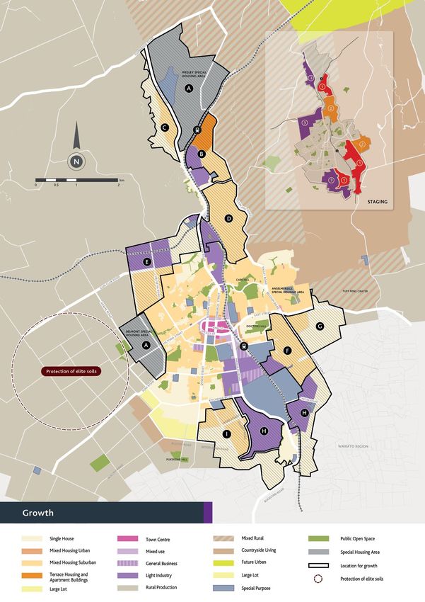
4. GROWTH OUTCOMES
As Pukekohe is anticipated to have significant population and employment growth over the next 30 years, the area plan
needs to consider where new residential, business, local centres and open space could be located. This chapter identifies
how to deliver well-coordinated growth that provides housing choices and more employment opportunities.
TE KUNENGA KI PUKEKOHE
OUTCOME 4.1 ACTION
This Area Plan guides 4.1.1 Work with landowners and developers to progress structure planning through plan
Growth in the where new zones could changes to the Unitary Plan for the future growth areas around Pukekohe in general
Future Urban Zone be located and sets out accordance with the Future Urban Zone growth map and schedule. Some of these plan
possible sequencing for changes may be council led while others will be developer led.
this future growth.
This schedule sets out a high level development strategy for growth in the Future Urban Zone:
A B C D E F G H I
Wesley College South Paerata Pukekohe Buckland/
and Belmont Northeast Paerata Northwest Paerata Pukekohe northwest Pukekohe east Pukekohe south
and Adams Drive east central Pukekohe Hill
Wesley College and Light industrial, Mixed housing and Mixed housing and Mixed housing and Mixed housing and Mixed housing and Light industrial and Mixed housing and
Belmont Special terrace housing and single housing light industrial light industrial light industrial single house single house single house
Housing Areas apartments, mixed
housing
These areas are This area could extend the This area could provide A large area of mixed This area could A light industrial zone This area is anticipated This area is well New east–west transport The area between
where the fast track existing residential and for a mix of residential housing could be accommodate could complement to accommodate a mix connected to existing linkages may be required to Buckland and Pukekohe
development of industrial development housing that responds developed, with mixed housing and existing uses at the of residential densities industrial and business service the area and there Hill could accommodate
housing will take place, in Paerata and enable to the landscape, rolling approximately 20ha approximately 70ha raceway, and be less to respond to the rolling land around Manukau are known geotechnical a mix of residential
having been approved higher density housing and topography and streams in of light industrial of light industrial sensitive to noise than topography, stream Road, and is close to constraints. densities to respond to
by central government additional employment this area. land potentially being development. The mixed other urban activities network and landscape existing infrastructure The area identified for the landscape values of
as Special Housing around a future train developed north of Adams housing areas could (e.g. housing). Further values. connections. A light single housing could Pukekohe Hill.
Stage: 3
Areas. station. There are known Drive. There are some provide an extension to from the raceway, the industrial zone could provide for low density
Stage: 2 Stage: 3
geotechnical constraints in flooding and geotechnical the existing residential closeness of the train enable more automotive residential similar to
Stage: NA
this area which will require constraints in this area, as development at Lough station makes this and equestrian services, the existing housing in
investigation through the well as sensitive landscape Bourne Drive. A light a good location for complementing existing Buckland village.
structure plan process. and ecosystems that will industrial zoning at mixed housing. uses at the raceway. These
need to be considered Heights Road would activities would also be Stage: 1
Stage: 1 Stage: 1
carefully through the allow the expansion of less sensitive to noise than
structure planning process. existing rural service and other urban activities
Stage: 2 industry activities and (e.g. housing).
enable similar activities
to locate there. Flooding
is a known constraint in
this area.
Stage:3
• The eight principles to guide Pukekohe’s growth (please see engagement and feedback chapter for discussion on these
It is important to note that while the Future Urban Zone growth map and schedule set out the council’s high level analysis of where future The following principles)
zones should go – the map and schedule is to be used as a guide only as additional constraints and opportunities may not be known until matters were • Provide enough residential land to accommodate the doubling of Pukekohe’s population over the next 30 years to 50,000
structure planning for these areas is undertaken. Future structure planning for these areas will involve thorough analysis of issues such considered when • Provide options for the needs of the growing population – affordable housing, a mix of housing choices, housing for the
thinking about what elderly, papakāinga housing, housing close to public transport, access to open space, local employment opportunities
as catchment management planning, servicing, transport, infrastructure, natural environment, landscape, recreation needs and economic
the growth areas • Propose zones which are in line with Council’s direction for a compact city, ensuring urban densities and ensuring infra-
effects, resulting in refinement of the extent of specific live zones. could contain: structure investment can be optimised
It is anticipated that stage 1 areas will be subject to structure planning in the next 1–5 years, stage 2 areas in the next 5–10 years and • Provide more light industrial and commercial land to provide 9000 additional local jobs over the next 30 years
stage 3 areas in the next 10–30 years. • Respond to known constraints and considerations such as heritage, contamination, geotechnical conditions, noise concerns,
flooding, steep slopes, significant natural areas, servicing requirements and transport
27 2829
PART C: IMPLEMENTATION
IMPLEMENTING THE AREA PLAN
TE WHAKATINANA I TE MAHERE A-ROHE

The Pukekohe Area Plan identifies    The Unitary Plan                              Long-term Plan (LTP) & Annual Plan              Franklin Local Board Plan                     The Auckland Design Manual
a number of outcomes as well         This area plan offers preliminary             This area plan will inform the LTP review       The Franklin Local Board Plan has played      This area plan promotes Town Centre
as associated actions to achieve     suggestions for possible business,            cycle and includes those projects already       a key role in helping to define this area     Character guidelines as an action.
                                     residential and public open space zones       funded within the council’s current LTP as      plan’s priorities, projects and community
them. The statutory and non-         within the Future Urban Zone. Structure       well as identifying any unfunded projects       aspirations. Local board plans are reviewed   These would provide design guidance
                                                                                                                                                                                 for new development and also the
statutory tools described below      planning and plan changes would be            that should be considered for funding           every three years and future plans will in
                                                                                                                                                                                 maintenance and restoration of its heritage
                                     required to change the zoning from the        priority in the next LTP (2015–2025),           turn be influenced by this area plan.
will be used to help deliver these   Future Urban Zone to these and other          which is anticipated to be adopted by the                                                     buildings in order to help protect the town
                                                                                                                                                                                 centre’s character.
outcomes and actions over the        ‘urban’ zones.                                governing body in June 2015.
next 30 years.                       Appendix 1.1 of the Proposed Auckland         If funding for any projects are not allocated                                                 Town Centre Character guidelines for
                                     Unitary Plan identifies the Structure plan    through this then funding will need to be                                                     Pukekohe could be undertaken as part of
                                     requirements for future urban zoned           reviewed in the next Long-term Plan review                                                    the Auckland Design Manual currently
                                     ‘greenfield land’ and ‘brownfield land’.      process (which occurs every three years).                                                     being developed by the council.
                                     Structure plans establish the spatial                                                                                                       The Auckland Design Manual provides
                                     development pattern of land use and the       This area plan will also inform the council’s
                                                                                   Annual Plan review process.                                                                   practical advice, best practice processes
                                     transport and services network within a                                                                                                     and detailed design guidance inclusive of
                                     defined area. A detailed examination of                                                                                                     Te Aranga Māori design principles to enable
                                     the opportunities and constraints relating                                                                                                  us to design and build the world’s most
                                     to the land is required and will ensure the                                                                                                 liveable city. Alternatively, the local board
                                     effects of development are addressed in                                                                                                     may opt to commission guidelines directly.
                                     advance of development occurring.
                                     The area plan also contains
                                     recommendations for the protection of
                                     key landscape features and heritage items
                                     through changes to the Unitary Plan.

31                                                                                                                                                                                                                         32
You can also read