BARKLEY COMMUNITY FOREST FOREST STEWARDSHIP PLAN - May 26, 2021
←
→
Page content transcription
If your browser does not render page correctly, please read the page content below
BARKLEY COMMUNITY FOREST
 FOREST STEWARDSHIP PLAN
      Barkley Community Forest Agreement K3S

    Barkley Community Forest Limited Partnership

                  May 26, 2021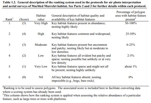
BARKLEY COMMUNITY FOREST                                  May 26, 2021

Signatory Page

 Signature of Person Required to Prepare the Plan:

 Licence: Community Forest Agreement K3S

 Licensee: Barkley Community Forest Limited Partnership

 _______________________
 Zoltan Schafer R.P.F
 General Manager
 Barkley Community Forest Limited Partnership Licensee

 “I certify that I have determined that this work was
 performed to an acceptable standard.”

    Forest Stewardship Plan                                          i
BARKLEY COMMUNITY FOREST May 26, 2021
Contents
Signatory Page ........................................................................................................................................................... i
Contents ................................................................................................................................................................... ii
List of Figures........................................................................................................................................................... iii
List of Tables ............................................................................................................................................................ iii
Acronyms ................................................................................................................................................................. iii
1 Introduction ................................................................................................................................1
2 Applications.................................................................................................................................1
2.1 Changes to Legislation ...................................................................................................................................2
2.2 Objectives Cancelled .....................................................................................................................................2
3 Definitions ...................................................................................................................................2
4 Submission Approval and Term ....................................................................................................3
5 Forest Development Units ............................................................................................................3
5.1 Areas to which FRPA S. 196 (1) or (2) or FPPR S. 110 Applies (FPPR S. 14 (1) (c)) .........................................5
5.2 Designations in Effect Four Months before Submission of this FSP (FPPR S. 14 (3)) .....................................5
5.3 Areas Within Outer Boundaries of FDU Subject to Cutting Permit or Road Permit (FPPR S. 14 (3)(j)) .........5
6 Results or Strategies ....................................................................................................................6
6.1 Land Use Objectives – Established by Order .................................................................................................6
6.1.1 Order Establishing Provincial Non-Spatial Old Growth Objectives ................................................... 7
6.1.2 Vancouver Island Land Use Plan Higher LEvel Plan Order .............................................................. 10
6.2 Objectives Set by Government – Section 149 of the Forest and Range Pratices Act ..................................13
6.2.1 Soils ................................................................................................................................................. 13
6.2.2 Wildlife ............................................................................................................................................ 14
6.2.3 Water, Fish, Wildlife and Biodiversity in Riparian Areas ................................................................. 20
6.2.4 Fisheries Sensitive Watersheds ....................................................................................................... 21
6.2.5 Community Watersheds ................................................................................................................. 22
6.2.6 Wildlife and Biodiversity – Biodiversity Objective - Landscape Level ............................................. 23
6.2.7 Wildlife and Biodiversity – Biodiversity Objective - Stand Level ..................................................... 24
6.2.8 Cultural Heritage Resources ............................................................................................................ 25
6.3 Objectives and Measures Set Under the Government Actions Regulation (GAR) ......................................29
6.3.1 Visual Quality Objectives ................................................................................................................ 29
7 Measures................................................................................................................................... 31
7.1 Measure to Prevent the Intorduction and Spread of Invasive Plants .........................................................31
7.2 Natural Range Barriers ................................................................................................................................34
8 Stocking Standards..................................................................................................................... 35
8.1 Situations or Circumstances that determine whether Free Growing is Assessed on a Block Basis or Across
Blocks ...........................................................................................................................................................35
8.2 Regeneration Date and Stocking Standards, Free Growing Height .............................................................35
8.3 or Circumstances that Determine when FPPR S. 44(4) and the Standards Applicable Under FPPR S.16 (4)
Applies .........................................................................................................................................................35
8.4 FRPA S. 197 (7) Election for Stocking Standards ..........................................................................................35
Appendix 1 – FSP Overview Map ...................................................................................................... 36
Appendix 2 – Stocking Standards ...................................................................................................... 37
Forest Stewardship Plan iiBARKLEY COMMUNITY FOREST May 26, 2021
List of Figures
Figure 1. Overview of the Barkley Community Forest Forest Development Unit. ............................................................................ 4
Figure 2. General description of the ranking system used in the protocols for air photo interpretation and aerial surveys of
Marbled Murrelet habitat. ............................................................................................................................................ 17
List of Tables
Table 1. Forest Development Units .................................................................................................................................................. 3
Table 2. Designations in Effect Prior to FSP Submission ................................................................................................................... 5
Table 3. Cutting Permits and Road Permits in Place prior to FSP Submission................................................................................... 6
Table 4. Old Growth Targets by Landscape Unit (June 2016) ......................................................................................................... 10
Table 5. VILUP Enhanced Resource Management Zones ................................................................................................................ 11
Table 6. Established Wildlife Habitat Areas Overlapping the FDU. ................................................................................................. 16
Acronyms
BC British Columbia TSA Timber Supply Area
BCF Barkley Community Forest UWR Ungulate Winter Range
BCFC Barkley Community Forest Corporation VILUP Vancouver Island Land Use Plan
BEC Biogeoclimatic Ecosystem Classification VLI Visual Landscape Inventory
CFA Community Forest Agreement VQO Visual Quality Objective
CHR Cultural Heritage Resource VRI Vegetation Resource Inventory
CMT Culturally Modified Tree WHA Wildlife Habitat Area
CWS Community Watershed
DBH Diameter at Breast Height
EFZ Enhanced Forestry Zones
FDU Forest Development Unit
FLNRORD Forest Lands Natural Resource Operation
and Rural Development
FMLB Forest Management Land Base
FPPR Forest Planning and Practices Regulation
FRPA Forest and Range Practices Act
GAR Government Action Regulation
GIS Geographical Information System
HLP Higher Level Plan
LU Landscape Unit
NAR Net Area to be Reforested
NDT Natural Disturbance Type
NHLB Non-Harvestable Land Base
OGMA Old Growth Management Area
RMZ Resource Management Zone
ROA Reasonable Opportunity Agreement
RPF Registered Professional Forester
SI Site Index
SIRD South Island Resource District
THLB Timber Harvesting Land Base
Forest Stewardship Plan iiiBARKLEY COMMUNITY FOREST May 26, 2021
1 Introduction
A Forest Stewardship Plan (FSP) must be prepared by all forest agreement holders (Licensees), and
approved by the provincial government before associated permits can be issued to the Licensee. As per
the Forest and Range Practices Act (FRPA), an FSP must specify results or strategies that describe how the
Licensee will ensure that their operations on the ground are consistent with government set objectives
for soil, timber, wildlife, water, fish, biodiversity, visual quality, cultural heritage, recreation, invasive
plants and natural range barriers. An FSP also describes how a Licensee will re-establish a healthy
productive forest stand after harvest.
This FSP will replace the Barkley Community Forest FSP, approved in September 2016, which is due to
expire in September 2021. This replacement FSP outlines how the Licensee, Barkley Community Forest
(BCF), will be accountable for all the management strategies and actions to which they have committed
as either a result or a strategy. By ensuring that every action is measurable or verifiable, the BCF can
demonstrate sustainable forest management and continual review and improvement in their ongoing
practices.
The structure of this document is non-traditional. The information which would have typically been found
in the FSP supporting material documents is combined into this FSP for clarity and ease of reading by the
public. Not all statements in this plan are intended to create legally binding obligations. Plain language
summaries are provided under the heading ‘Context’; this includes the information which would have
previously been found in the supporting information package. This modified FSP format has been
developed in response to recommendations provided in the “Forest Stewardship Plans: Are They Meeting
Expectations?” special investigation completed by the Forest Practices board in 20151. Each section then
includes the Legal Reference, and the legally enforceable Results or Strategies, as well as how the Results
or Strategies can be verified or measured.
2 Applications DEFINITIONS
This FSP applies to each cutting permit and road Result – A description of measurable or
verifiable outcomes for a particular established
permit issued or granted to the Holders of
objective, and the situations or circumstances
agreements, and for the agreements, listed in Table that determine where in a forest development
1 that is issued or granted: unit these outcomes will be applied.
(a) after the Commencement Date of this FSP;
and Strategy – A description of measurable or
verifiable steps or practices that will be carried
(b) within the Forest Development Units (FDUs) out for a particular established objective, and the
under this FSP. situations or circumstances that determine
where in a forest development unit the steps or
A Community Forest Agreement is an area-based, practices will be applied.
licence managed by a local government, community
Forest Planning and Practices Regulation, Section1 (2)
group, First Nation or combination of local
governments, First Nations and community groups,
1 https://www.bcfpb.ca/reports-publications/reports/forest-stewardship-plans-are-they-meeting-expectations/
Forest Stewardship Plan 1BARKLEY COMMUNITY FOREST May 26, 2021
for the benefit of the entire community.2.
The Barkley Community Forest Corporation (BCFC) is jointly owned by the District of Ucluelet and the
Toquaht Nation. The BCFC is authorized by the Province of British Columbia under the Barkley Community
Forest Agreement K3S to an allowable cut of 27,000 cubic meters and an initial term of 25 years. The
Community Forest Agreement Area covers 6,757 hectares next to the Maggie Lake Watershed. The holder
of this FSP is the Barkly Community Forest Limited Partnership, a subsidiary of the BCFC. The FSP in effect
at the time of harvest applies and will continue to apply to those cutblocks until such time they are
removed from the Licensee’s responsibility (typically once declared free to grow).
2.1 CHANGES TO LEGISLATION
If legislation referred to in this FSP is renamed or a provision of legislation referred to in this FSP is
renumbered, the reference in this FSP is to be construed as a reference to the provision as renamed or
renumbered, as the case may be.
2.2 OBJECTIVES CANCELLED
If an established objective for which a result or strategy is included under this FSP is cancelled, the result
or strategy under this FSP pertaining to that objective is no longer applicable, effective on the date of
cancellation of the objective.
3 Definitions
Unless otherwise expressly indicated, or indicated by context, terms used in this FSP have the definition
given to them in the Forest Act, Forest and Range Practices Act and the regulations under them, as
amended from time to time.
Agreement Holder – Also the “Holder of this FSP” or just the “Holder”. Refers to the Licensee(s) to
whom this FSP applies.
FPPR – The Forest Planning and Practices Regulation as amended from time to time.
FRPA – The Forest and Range Practices Act, SBC 2002, c.69, as amended from time to time.
FSP – Refers to this Forest Stewardship Plan.
Licensee – Refers to Barkly Community Forest Limited Partnership, also known as Barkley Community
Forest Corporation in this FSP.
Primary Forest Activities – Means one or more of the following:
a) Timber harvesting,
b) Silviculture, and
c) Road construction, maintenance and deactivation.
Qualified Professional – means an applied scientist or technologist, acting alone or together with
another professional, if:
2 https://www2.gov.bc.ca/gov/content/industry/forestry/forest-tenures/timber-harvesting-rights/community-forest-agreements
Forest Stewardship Plan 2BARKLEY COMMUNITY FOREST May 26, 2021
The individual is registered and in good standing in British Columbia with an
appropriate professional organization constituted under an Act, is acting under that
association’s code of ethics and is subject to disciplinary action by that association;
and
The individual is acting within that individual’s area of expertise.
RPF – Registered Professional Forester as defined by the Forest Professional Regulation under the
Professional Governance Act and registered with the Association of BC Forest Professionals in
good standing.
4 Submission Approval and Term
FRPA S. 6 (1) (a) (b) and S. 6 (2)
The date of submission of this Forest Stewardship Plan (FSP) is the date received by the Ministry of Forests,
Lands and Natural Resource Operations, South Island District (the “Date of Submission”).The term of this
FSP will be five (5) years, effective from the date of approval.
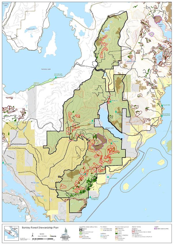
5 Forest Development Units
FRPA S. 5 (1) (a) and FPPR S. 14
The Barkley Community Forest is located primarily within the Maggie Landscape Unit, (LU), with the
Stopper Islands located in the Barkley Sound Islands LU and very small overlap into the Toquaht LU along
the northeast boundary. There is one Forest Development Unit (FDU) - FDU #1 - which comprises the area
under the Barkley Community Forest Agreement that falls within the Maggie LU as shown in Figure 1 and
as identified on the FSP overview map (Appendix 1 – FSP Overview Map). The FDU #1, hereafter referred
to as ‘the FDU’, is located solely within the Maggie Landscape Unit, (LU). The results and strategies within
this FSP apply to the entirety the FDU and to the term of the FSP unless otherwise stated.
Table 1. Forest Development Units
FDU LU Area
FDU #1 Maggie 6346 ha
Forest Stewardship Plan 3BARKLEY COMMUNITY FOREST May 26, 2021 Figure 1. Overview of the Barkley Community Forest Forest Development Unit. Forest Stewardship Plan 4
BARKLEY COMMUNITY FOREST                                                                      May 26, 2021

 5.1 AREAS TO WHICH FRPA S. 196 (1) OR (2) OR FPPR S. 110 APPLIES (FPPR S.
     14 (1) (C))
The attached FSP Map (Appendix 1) shows any cutblocks and roads included in Forest Development Plans
(FDP) that are within the FDU under this FSP and considered approved under S. 196(1) or (2) of the Act,
including those cutblocks referred to in S. 110 of the FPPR.

 5.2 DESIGNATIONS IN EFFECT FOUR MONTHS BEFORE SUBMISSION OF THIS
     FSP (FPPR S. 14 (3))
The FSP Map shows the designations and content requirements described in S. 14(3) of the Forest
Planning and Practices Regulation (FPPR) that were in effect on the Date of Submission, including, for ease
of reference, the designations listed in Table 2.

Table 2. Designations in Effect Prior to FSP Submission
 FPPR Objective and Associated Designation(s)                      Landscape         Date Designated
                                                                   Unit
 FPPR S. 14 (3) (a) Ungulate Winter Ranges
 None
 FPPR S. 14 (3) (b) Wildlife Habitat Areas
 WHA 1-210 - Marbled Murrelet                                        Maggie LU        January 21, 2008

 FPPR S. 14 (3) (c) Fisheries Sensitive Watersheds
 None
 FPPR S. 14 (3) (e) Scenic Areas
 2 (Highway 4 from Parksville to Ucluelet)                           Maggie LU       December 30, 2011
 7 Barkley Sound, including views between Tzartus Island
 and Toquart Bay)
 8 (Coastal shorelands between Toquart Bay and Ucluelet)
 9 (Toquart River Valley to the North end of Toquart Lake)
 10 (Effingham Inlet, Pipestem Inlet)
 FPPR S. 14 (3) (g) Community Watersheds
 None
 FPPR S. 14 (3) (h) Old Growth Management Areas (draft)
 TSA portion                                                         Maggie LU        January 25, 2005
                                                                                          (under S. 8
                                                                                      of the Old Growth
                                                                                            Order)

 5.3 AREAS WITHIN OUTER BOUNDARIES OF FDU SUBJECT TO CUTTING PERMIT
     OR ROAD PERMIT (FPPR S. 14 (3)(J))
The FSP Map shows the areas that are within the outer boundaries of the FDU but subject to a cutting
permit or road permit.
In additions to the map, Table 3 provides a list of the cutting permits and road permits are within the
outer boundaries of the FDU:

Forest Stewardship Plan                                                                                   5
BARKLEY COMMUNITY FOREST May 26, 2021
Table 3. Cutting Permits and Road Permits in Place prior to FSP Submission
License Held By Applicable FDU Permit
Community Barkley FDU 1 Cutting Permit Approved under previous FSP
Forest Community CP 10 Block OZ 4
Agreement Forest CP 11 Blocks SB15/SB16A/SB18
K3S Corporation CP 12 Blocks DC 10/DC11/DC12/DC13
Cutting Permit Harvested under previous FSP
CP 5 BLKS MAG 1, MC 3 SB 8 and SB 9
CP 6 BLKS SB10 and SB 11
CP 7 BLKS OZ1 and OZ2
CP8 BLK OZ 3
CP 9 Blocks MC4/5
Salvage Permit
None
Active Road Permit R21331
FSR to be transferred to R21331
9614 – Ucluelet area
6 Results or Strategies
The following essential elements are applicable to each result or strategy unless otherwise stated in the
result or strategy:
Who: the Licensee
What: primary forest activities
Where: the FDU
When: for the term of this FSP or until such time cutblocks harvested under this FSP are removed
from the Licensee’s responsibility (typically once declared free to grow).
The sub-sections below have been organized with legally binding results or strategies, as well as non-
legally binding context (background and references) and a description of how the result or strategy will
be measured/verified.
6.1 LAND USE OBJECTIVES – ESTABLISHED BY ORDER
Context
The Land Use Objectives Regulation (LUOR), under the Land Act, authorizes the Minister of Agriculture
and Lands (MAL) to establish legal land use objectives for the purposes of the Forest and Range
Practices Act (FRPA).
The following Orders provide land use objectives within the South Island District and have been
addressed as objectives with results and strategies under this FSP:
Landscape Level Order
1) Order Establishing Provincial Non-Spatial Old Growth Objectives
The Order established provincial non-spatial growth objectives with the intent to identify the
amount of old forest that will be maintained to address biodiversity values across the province
Forest Stewardship Plan 6BARKLEY COMMUNITY FOREST May 26, 2021
of British Columbia. The Order supplements, but does not replace FPPR S. 9.
Regional Land Use Plans under Order
2) Vancouver Island Land Use Plan Higher Level Plan Order, 2000
The Order established resource management zones and resource management zone objectives
within the area covered by the Vancouver Island Land Use Plan.
3) Order cancelling Resource Management Zone Objectives for Joint Approval of Forest
Development Plan, 2002
The Order cancels provision 3 of the 2000 Vancouver Island Land Use Plan – Higher Level Plan
Order.
The following Government Action Regulations (GAR) Orders are in place in the South Island District,
however the features that they provide objectives for are not currently identified with the FSP area:
4) GAR Order to Identify Recreation Sites, Trails and Interpretative Forest Sites as Resource
Features for the South Island Forest District Under Sec. 5(1)(f) GAR. (December 01, 2005)
There are no identified features within the FDU
5) GAR Order to Identify Karst Resource Features under Sec. 5(1)(a) GAR. (December 11, 2009)
There are no identified features within the FDU
Other objectives established by Order include Section 7 Species at Risk Notices and Wildlife Habitat
Areas which have been included under Section 6.2.2 Wildlife to provide a more functional, readable
and relatable format to the FSP.
6.1.1 ORDER ESTABLISHING PROVINCIAL NON-SPATIAL OLD GROWTH
OBJECTIVES
Context
The Order Establishing Provincial Non-spatial Old Growth Objectives (effective June 30, 2004) (the
Order) clarifies the amount of area available for timber harvesting. This Order supplements, but does
not replace, FPPR S. 9.
The overlap between the Maggie LU (RMZ 40) and the BCF is 6421 ha, or 95% of the BCF area. This area
has been assigned a low Biodiversity Emphasis Option (BEO), this is appropriate for areas where other
social and economic demands, such as timber supply, are the primary management objectives. This
BEO fits well with the objectives of the community forest.
The draft spatial OGMAs presented in the FSP cover the entire FDU and utilize the percent old forest
retention target of the Maggie LU (Table 4). Within the greater BCF area, the small area of Toquaht LU
included is primarily young forest and the Stopper Islands from the Barkley Sound Islands LU are mature
and old forest which contribute to the draft spatial OGMA presented in this FSP (BCF FSP 2021).
The draft OGMAs within the FDU (area of the BCF in the Maggie Landscape Unit (LU)), were designated
on January 25th, 2005 under the Old Growth Order (FPPR Section 8) (BCF FSP 2016). The Maggie LU has
a Low Biodiversity Emphasis (BEO) and therefore the target for the retention of old growth within each
BEC Variant is 13%. There are 3 BEC Variants within the Maggie LU, the CWHvh1, the CWHvm1 and the
CWHvm2 and the respective old growth targets for each are 53.9 ha, 208.2 ha and 8.8 ha (BCF FSP
Forest Stewardship Plan 7BARKLEY COMMUNITY FOREST May 26, 2021
2016).
Non-Spatial Old Growth Objectives
Legal Reference Result and Strategy
Order Establishing The Order Establishing Non-Spatial Old Growth Objectives requires
Provincial Non-Spatial Licensees to prepare results and strategies to meet landscape unit
Old Growth Objectives biodiversity emphasis and Old growth objectives. The Licensee
(effective June 30, 2004) commits to the following results and strategies:
For the purposes of these results/strategies:
“retention targets” are:
a. Those by biogeoclimatic variant as defined in the Order;
and
b. refined by applying the 1/3 drawdown to the retention
targets in those LUs with a low biodiversity emphasis
option rating (BEO) (Table 4 Column 8), where the target
amount of old growth will be met by the end of the third
rotation.
“non-contribution land base” is as described in the Regional Land Use
Planning Database (RLUPS version 3.2 August 15, 2005).
“draft OGMA” are those old growth management areas identified
consistent with provision A8 of the Order and provisions
2 (c) and 6 of the Implementation Policy.
Strategies
1) If the Holder(s) of this FSP constructs a road or harvests a cutblock
in the areas to which the Order Establishing Provincial Non-Spatial
Old Growth Objectives (the Order) applies, the Holder(s) of this
FSP will do so by not harvesting old forest area in the non-
contributing land base (Table 4 Column 7) to the extent of the
retention targets (Table 4 Column 8).
2) To the extent that the forest identified under subsection (1) is
insufficient to meet the retention targets, the Holder(s) of this FSP
will identify this amount as a shortfall (Table 4 Column 9) and to
the extent of the shortfall:
a) determine if the identified shortfall can be achieved in the old
forest in the timber harvesting land base and in the mature
forest in the non-contributing land base (Table 4 Column 14);
and
b) construct roads or harvest cutblocks without harvesting
mature forest area assessed to have old forest structure in the
non-contributing land base; and/or
c) construct roads or harvest cutblocks not harvesting old forest
area in the timber harvesting land base.
Forest Stewardship Plan 8BARKLEY COMMUNITY FOREST May 26, 2021
3) In addition to subsections (1) and (2), in accordance with the
Implementation Policy3, the FSP Holder(s) may identify draft Old
Growth Management Areas (OGMAs).
4) Subsections (1), (2) and (3) apply:
a) to the portions of Landscape Units (LUs) listed in Table 4 which
fall under this FSP;
b) to the extent of the retention targets, any identified shortfall,
and to the extent possible by LU and biogeoclimatic variant;
c) to the extent of the Order; and
d) to the portions of LUs that are not the subject of an Order
establishing Higher Level Plan Objectives for the LU or a
written notice specifying that the draft OGMAs meet the
intent of the non-spatial order; and
until such time that:
e) the Minister4, his delegate, or other authorized representative
of government, or a licensee or a group of licensees identifies
draft OGMAs, for portions or entire LUs; and
f) the Minister, his delegate, or other authorized representative
of government specifies in writing that draft OGMAs meet the
intent of the Order for portions or entire LUs, as under
Provision A8 of the Order; or
g) there is an Order establishing Higher Level Plan Objectives for
portions of or entire LUs.
5) In addition to subsections (1) through (4), and subject to
subsection (7), where subsection (3) and/or (4) (e) and (4) (f)
applies in a biogeoclimatic variant in which a shortfall exists, the
Holder(s) of this FSP will not propose road construction or cutblock
harvesting in draft OGMAs.
6) In addition to subsection (1) through (5), and subject to subsection
(7), where subsections (4) (f) or (4) (g) apply, the Holder(s) of this
FSP, in accordance with the Order establishing Higher Level Plan
Objectives for the LU or the written notice specifying that the draft
OGMAs meet the intent of the non-spatial Order, will:
a) maintain or recruit old growth forest attributes within draft
OGMA or OGMA; and
b) will conduct road construction or cutblock harvesting or other
such operations within draft OGMA or OGMA in accordance
with the written notice specifying that draft OGMAs meet the
intent of the non-spatial Order, or the Order establishing
Higher Level Plan Objectives for the LU; and
3 The Implementation Policy provides guidance for the implementation of the provincial order for non-spatial old growth objectives.
https://www.for.gov.bc.ca/ftp/DSI/external/!publish/Stewardship/SIFD_Objectives_Matrix/6_Biodiversity/Old_Growth_Order_Implementation
_Policy_March_19_2004.pdf.
4 The Order Establishing Provincial Non-Spatial Old Growth Objectives and the Implementation Policy define that “Minster” means the Minister
of Sustainable Resource Management (SRM). The SRM has been continued under the Ministry of Forest, Lands, Natural Resource Operations
and Rural Development (FLNRORD) and “Minster” now refers to the Minster of FLNRORD.
Forest Stewardship Plan 9BARKLEY COMMUNITY FOREST May 26, 2021
c) update the draft OGMA spatial layer annually.
7) To the extent that proposed road construction or cutblock
harvesting overlaps draft OGMAs specified in a written notice as
meeting the intent of the Order, FSP Holder(s) will construct roads
or harvest cutblocks provided that the road construction or
cutblock harvesting is consistent with subsections (1), (2) and (3).
Scale of
LU
Measurement:
Map Reference: Appendix 1: Overview Map of the Forest Development Unit
Monitoring (Measures and Verification):
Draft OGMA commitments are measurable and verifiable at the landscape unit level. BCF conducts
Draft OGMA updates, completed by the appropriate qualified professional, in this case a Registered
Professional Biologist, to maintain ongoing monitoring and management of OGMA targets within the
BCF. Updates include:
a summary of the area of each BEC Variant represented in the BCF;
the old growth target for Low Biodiversity Emphasis of 13% for the Maggie LU;
the amount of old growth and mature forests available;
the area of old growth that has been retained in draft OGMAs;
the current area of the OGMAs as of a specified date; and
the area that exceeds the target for the low BEO of 13%.
Annual updates are provided to the District in writing when there has been a modification to the Draft
OGMA area as a result of harvesting.
Table 4. Old Growth Targets by Landscape Unit (June 2016)
Can Short Fall OG Forest
Mature
Old Growth Short Fall OG Available Mature be Achieved in Area within
Old Non- Forest Area
Landscape Biodiversity BEC Forested Target (1/3 Additional in Non- Available OG_THLB and Draft OGMA
Growth Contributing (Ha) within
Unit Emphasis Variant Area (Ha) Target for OG to Meet Contributing in THLB Mature (Ha) after
Target Old Forest Draft
Low BEO) Target (Ha) (Ha) (Ha) Non_Contribut Depletions
OGMA
ing since 2016
Maggie Low CWHvh1 1243.5 1/3 206.8 53.9 0 452.4 2.4 Yes 11.2
Maggie Low CWHvm1 4805.5 1/3 230.9 208.2 0 968.2 312 Yes 286.5 48.7
Maggie Low CWHvm2 202.7 1/3 25.1 8.8 0 36.3 0 Yes 23.5
6.1.2 VANCOUVER ISLAND LAND USE PLAN HIGHER LEVEL PLAN ORDER
HLP Order Objective 7
7. To increase the short-term availability of timber,
a) a cutblock may be larger than 40 ha pursuant to section 11(2)(a) of the OPR; and
b) pursuant to section 68(4) of the OPR, a cutblock is greened-up if it is adequately stocked and the
average height of those trees that are
i) the tallest tree in each 0.01 ha plot included in a representative sample, and
ii) a commercially valuable species or other species acceptable to the district manager
is at least 1.3 meters;
unless the district manager determines that a cutblock referred to under (a) or (b) would significantly
impact specific hydrological, wildlife, biodiversity, scenic or recreation values.
Forest Stewardship Plan 10BARKLEY COMMUNITY FOREST May 26, 2021
HLP Order Objectives 9 and 9.1
9. When proposing the species composition for the purposes of OPR section 39(3)(o), a person may,
pursuant to OPR section 41, select a single species that is ecologically suited to the area, if a mix of
species was present on the area before the timber was harvested.
9.1. The area that may be subject to selection of a single species pursuant to objective 9 is limited to
no more than 20 percent of the forested area of any variant within a given EFZ.
Context
The Vancouver Island Land Use Plan, Higher Level Plan (HLP) Order (effective December 1, 2000)
establishes Resource Management Zones and Resource Management Zone Objectives within the area
covered by the Vancouver Island Land Use Plan (VILUP). The VILUP established different land use
categories or regional zones. The regional zones, or Resource Management Zones (RMZ), are further
identified as either General Management Zones (GMZ), Special Management Zones (SMZ), or
Enhanced Forestry Zones (EFZ).
The entire FDU falls within the Maggie LU and corresponds with RMZ 40. VILUP identifies RMZ 40 as
an EFZ. The intent of the EFZs is to identify forested lands which are suitable for increased timber
production. This will be achieved through both enhanced timber harvesting, as well as the promotion
of enhanced silviculture practices, such as intensive reforestation, spacing, pruning, and thinning and
innovative harvest practices.
EFZ units have been identified based on an assessment of the inter-relationship and significance of
timber and non-timber resource values, and based on regional scale resource information. They are
located in areas with particular suitability and capability for enhanced timber production, which also
avoid areas of particularly high non-timber values, such as community watersheds or high biodiversity
emphasis areas. All legislated environmental stewardship provisions under the FRPA and other
legislation apply in EFZ units. Enhancement of the timber resource is not intended to be at the
expense of significant non-timber resource values.
The applicable Higher Level Plan (HLP) Order Objectives for the Resource Management Zones (RMZ)
that overlap with the FSP area are listed in the following table:
Table 5. VILUP Enhanced Resource Management Zones
Enhanced Forestry Zone Applicable HLP Objective FDU
RMZ 40 – Maggie* 7, 8, 9, and 9.1 1
*Objectives 7, 9 and 9.1 apply save and except for the parts of those zones, which are designated as community watersheds as defined in
section 41 (8) of the Forest Practices Code of British Columbia Act.
The FDU does not overlap with any GMZ or SMZ identified under the VILUP.
VILUP Objectives
Legal Reference Results and Strategies
Forest Stewardship Plan 11BARKLEY COMMUNITY FOREST May 26, 2021
VILUP HLP Order HLP Order Objective 7
Objectives 7, 8, 9, 9.1
Strategies
1) For the purposes of HLP Order Objective 7, in RMZ-40 (Maggie
EFZ), the Holder of this FSP may harvest cutblocks and construct
roads within cutblocks that:
a) apply any silvicultural system; and
b) exceed 40 hectares; and
c) are adjacent to areas that are greened-up as provided in HLP
Order Objective 7 (b).
2) In addition to subsection (1) and for the purposes of HLP Order
Objective 7, in determining the size of a proposed cutblock in the
Maggie and EFZ, the non-greened up portion of a cutblock
adjacent to a cutblock proposed for harvest will be considered
part of the NAR.
Results
3) In order to avoid significant impacts to specific hydrological,
wildlife, biodiversity, or scenic values, cutblocks described in
subsection (1) will be consistent with:
a) hydrological values if consistent with results/strategies for HLP
Objective 8; and
b) wildlife values if consistent with results/strategies in FSP S.
6.2.2, for wildlife; and
c) wildlife and biodiversity values if consistent with
results/strategies in FSP S. 6.2.3 for water, fish, wildlife and
biodiversity within riparian areas; and
d) wildlife and biodiversity values are consistent with
results/strategies in FSP S. 6.2.6 and FSP S. 6.2.7 for wildlife
and biodiversity; and
e) scenic values if consistent with results/strategies in FSP S.
6.3.1 or visual quality
HLP Order Objective 9 and 9.1
Strategies
4) Subject to subsection (2), if the Holder(s) of this FSP constructs a
road or harvests a cutblock in the area of the Maggie EFZ where a
mix of species was present on the area before the timber was
harvested, and the cutblock or road is reforested using a single
species, the Holder(s) of this FSP:
a) will reforest the cutblock or road using a single species that is
ecologically suited to the area, using a preferred species as set
out in the applicable stocking standards; and
Forest Stewardship Plan 12BARKLEY COMMUNITY FOREST May 26, 2021
b) limit the area reforested using a single species referred to in
subsection (4) (a) to no more than 20% of the forested area of
any variant within a given EFZ.
Scale of
Site Plans
Measurement:
Map Reference: None
Monitoring (Measures and Verification):
The Holder of this FSP has committed, to adopting the strategies above which are verifiable at the site
plan level in conjunction with accepted field verification methods, including, but not limited to:
conducting detailed Visual Impact Assessments in scenic areas,
establishing viewpoints and site lines, and
post-harvest inspections to ensure results and strategies are achieved by harvesting.
6.2 OBJECTIVES SET BY GOVERNMENT – SECTION 149 OF THE FOREST AND
RANGE PRATICES ACT
Context
Objectives set by Government are defined in Section 149 of the Forest and Range Practices Act for the
purpose of managing and protecting forest and range values. These are broad objectives for soil,
timber, wildlife, water, fish, biodiversity, visual quality, cultural heritage and recreation, as well as
measures for invasive plants and natural range barriers. By way of this FSP, the Licensee has committed
to managing the resources and planning forest development in accordance with the objectives for each
of these values as outlined in the sub-sections below.
6.2.1 SOILS
Context
Healthy and productive soils are integral to growing future forests and thus forestry practices. Road
building must be carried out in a manner which limits soil disturbances and soil degradation as well as
erosion, landslides, and sediment delivery to water systems. In order to minimize disturbances from
primary forest activities, soil disturbance and permanent access structures (roads on the block,
landings, gravel pits, etc.) are regulated.
The Forest Planning and Practices Regulation (FPPR) limits soil disturbance on the harvested portion of
a cutblock as well as the percentage of permanent access structures5. Should circumstances warrant
exceeding these percentages, a rationale must be provided by a Qualified Registered Professional.
5B.C. Ministry of Forests and Range, 2004. Forest Planning and Practices Regulation.
http://www.bclaws.ca/EPLibraries/bclaws_new/document/ID/freeside/14_2004#section35. Accessed January 22, 2021
Forest Stewardship Plan 13BARKLEY COMMUNITY FOREST May 26, 2021
Soil Disturbance Limits and Permanent Access Structures
Legal Reference Results and Strategies
FPPR Sections 5, 35, and Result
36 The Licensee undertakes to comply with the practice requirements of
FPPR Sections 35 (Soil Disturbance Limits) and 36 (Permanent Access
Structure Limits).
In accordance with FPPR s. 12.1(1) and (5), the Holder of this FSP is
exempt from the requirement to specify intended results and
strategies set out in FPPR s.5.
Scale of
N/A
Measurement:
Map Reference: None
Monitoring (Measures and Verification):
The Licensee has committed to adopting the practices requirements specified in FPPR Sections 35 and
36, which are measurable and verifiable at the site plan level in conjunction with accepted field
verification methods. Strategies needed to meet this result would be prescribed at the site plan level
for the FDU, and may include, but are not limited to:
monitoring disturbance at the site plan level, and
deactivating and rehabilitation of spur roads, backspar, and hoe chuck trails to the extent that that
disturbance levels remain within the regulated amounts.
6.2.2 WILDLIFE
Objectives set by government for wildlife (FPPR S. 7)
1) The objective set by government for wildlife is, without unduly reducing the supply of timber from
British Columbia’s forests, to conserve sufficient wildlife habitat in terms of amount of area,
distribution of areas and attributes of those areas, for
a) the survival of species at risk,
b) the survival of regionally important wildlife, and
c) the winter survival of specified ungulate species.
2) A person required to prepare a forest stewardship plan must specify a result or a strategy in respect
of the objective stated under subsection (1) only if the minister responsible for the Wildlife Act gives
notice to the person of the applicable
a) species referred to in subsection (1), and
b) indicators of the amount, distribution and attributes of wildlife habitat described in subsection
(1).
3) If satisfied that the objective set out in subsection (1) is addressed, in whole or in part, by an
objective in relation to a wildlife a habitat area or an ungulate winter range, a general wildlife
measure, or a wildlife habitat feature, the minister responsible for the Wildlife Act must exempt a
person from the obligation to specify a result or strategy in relation to the objective set out in
subsection (1) to the extent that the objective is already addressed.
Forest Stewardship Plan 14BARKLEY COMMUNITY FOREST May 26, 2021 4) On or after December 31, 2004, a notice described in subsection (2) must be given at least 4 months before the forest stewardship plan is submitted for approval. Context Two categories of wildlife are established under the Forest and Range Practices Act by the Minister responsible for the Wildlife Act (the Minister of Environment and Climate Change) – Species at Risk and Regionally Important Wildlife. These categories have been established because the wildlife or wildlife habitat attributes recognized under them require special management attention to address impacts of forest and range activities on Crown land. Species at Risk include endangered, threatened, or vulnerable species of vertebrates and invertebrates, and endangered or threatened plants and plant communities that are negatively affected by forest or range management on Crown land. Species at Risk can also include those that are not adequately protected by other mechanisms. Regionally Important Wildlife includes species that are considered important to a region of BC, rely on habitats that are not otherwise legally protected, and may be adversely impacted by forest or range practices. In BC, these two categories of wildlife are referred to as Identified Wildlife. The establishment of these categories of species enables provisions under the Forest and Range Practices Act to manage identified wildlife species including wildlife habitat areas (WHAs), ungulate winter ranges (UWRs), and associated general wildlife measures and objectives. Section 9 the Government Actions Regulation (BC Reg. 582/2004) of FRPA describe the formal legislative basis general wildlife measures. Species at Risk6 There is currently one Section 7 Notice for Species at Risk in place that has implications within the FDU – Indicators of the amount, distribution and attributes of wildlife habitat required for the survival of species at risk in the South Island Forest District - dated December 21, 20047. Schedule 1 of the Notice identifies three species at risk within the South Island District (“Queen Charlotte” Goshawk, Marbled Murrelet, and Scouler’s Corydalis); however, only indicators of the amount, distribution and attributes of wildlife habitat required for the survival of the Marbled Murrelet have been identified within the FDU. The proposed Draft Section 7 Notice relating to the recovery of Marbled Murrelet, Notice – Indicators of the Among, Distribution and Attributes of Wildlife Habitat Requirements for the Survival of Marbled Murrelet (Brachyramphus marmoratus), is currently under review. This Notice will rescind Paragraph 2, December 30, 2004 in schedule 1 of the section 7(2) Notice for the South Island District. The Draft Notice, when approved, will include indicators of the amount, distribution and attributes of wildlife habitat required for the survival of the Marbled Murrelet. Wildlife Habitat Areas (WHA) Wildlife Habitat Areas (WHAs) are areas that have been deemed necessary to meet the habitat requirements of an Identified Wildlife element, such as salt licks or calving grounds. WHAs designate 6 Section 7 Notices for Species at Risk available at: http://www.env.gov.bc.ca/wld/frpa/notices/sar.html. Accessed April 1, 2021. 7https://www.env.gov.bc.ca/esd/distdata/ecosystems/frpa/Approved_FRPR_sec7_WLPPR_sec9_Notices_and_Supporting_Info/Species_at_Ris k/South_Island_FD/Notice/South%20Island%20FD_SAR.pdf Forest Stewardship Plan 15
BARKLEY COMMUNITY FOREST                                                                                               May 26, 2021

 critical habitats in which human activities are managed to limit their impact on the Identified Wildlife
 element. The purpose is to conserve those habitats considered most limiting to a given wildlife species.
 There is currently one (1) legally established WHA8 that overlaps the FDU (Table 6). The Licensee
 commits to comply with the measures set by Order for Marbled Murrelet. As circumstances regarding
 habitat change and the need arises to establish other WHAs, the Licensee will amend this FSP
 accordingly.
 Ministerial Orders in Draft
 The proposed Draft Ministerial Order, Order for the Recovery of Marbled Murrelet (Brachyramphus
 marmoratus) is currently under review. This Order will ensure the availability of suitable habitat meets
 or exceeds minimum habitat thresholds established for Provincial Crow land for the West Vancouver
 Island region. Under this Draft Order, the minimum habitat thresholds are established for landscape
 unit portions and landscape unit aggregates.
 Ungulate Winter Range (UWR)9
 There are no approved Ungulate Winter Range polygons designated within the FDU.

Table 6. Established Wildlife Habitat Areas Overlapping the FDU.

        WHA - ID                             Species                                   Date                   Area in the FDU
       #1-210                 Marbled Murrelet                                January 21, 2008                       87.02ha10

                 6.2.2.1 MARBLED MURRELET

 Context
 The Marbled Murrelet is a small north Pacific seabird that nests on large mossy platforms in old-growth
 forests. Murrelets lay a single egg in a small depression in the moss on large, wide branches of old-
 growth trees. Marbled Murrelets depend on old growth forest for nesting, and the loss of forest nesting
 habitat is considered the main cause of population decline across their range. The Marbled Murrelet
 was listed as threatened by the Committee on the Status of Endangered Wildlife in Canada in 1990 and
 is on British Columbia’s Blue List (species of concern)11.
 A Section 7 Notice, Notice - Indicators of the amount, distribution and attributes of wildlife habitat
 required for the survival of species at risk in the South Island Forest District12, was issued on December
 30th, 2004. This Notice provided indicators of amount, distribution and attributes of habitat for Marbled
 Murrelet and stated that the amount of habitat available must remain equal to the total amount of
 currently suitable nesting habitat in the non-contributing landbase as of December 2004. Further, the

8 Approved Wildlife Habitat Area: http://www.env.gov.bc.ca/cgi-bin/apps/faw/wharesult.cgi?search=wlap_region&wlap=Vancouver%20Island.
Accessed April 1, 2021.
9 Approved Ungulate Winter Range: https://www.env.gov.bc.ca/wld/frpa/uwr/approved_uwr.html. Accessed April 1, 2021
10 BC Data Warehouse: WHSE_WILDLIFE_MANAGEMENT.WCP_WILDLIFE_HABITAT_AREA, dated December 2020.
11 https://www2.gov.bc.ca/gov/content/environment/plants-animals-ecosystems/species-ecosystems-at-risk/implementation/conservation-
projects-partnerships/northern-goshawk-marbled-
murrelet#:~:text=The%20Marbled%20Murrelet%20is%20a,platforms%20in%20old%2Dgrowth%20forests.&text=The%20Marbled%20Murrelet
%20was%20listed,List%20(species%20of%20concern).
12https://www.env.gov.bc.ca/esd/distdata/ecosystems/frpa/Approved_FRPR_sec7_WLPPR_sec9_Notices_and_Supporting_Info/Species_at_Ri
sk/South_Island_FD/Notice/South%20Island%20FD_SAR.pdf

Forest Stewardship Plan                                                                                                           16
BARKLEY COMMUNITY FOREST May 26, 2021
habitat can include an amount of suitable Marbled Murrelet nesting habitat with OGMAs consistent
with the direction from LU planning.
Suitable habitat is identified in accordance with the Standard Methods for Identifying and Ranking
Nesting Habitat of Marbled Murrelets (Brachyramphus Marmoratus) in British Columbia Using Air Photo
Interpretation and Low-Level Aerial Surveys. Figure 2 outlines the ranking system and general protocols
described in the Standard Methods:
Figure 2. General description of the ranking system used in the protocols for air photo interpretation
and aerial surveys of Marbled Murrelet habitat.
The original Marbled Murrelet nesting habitat inventory (2004) identified a total of 297.65 ha of Class
1-3 suitable habitat in the BCF:
In 2008, an 87 ha Wildlife Habitat Area (WHA) 1-210 was established in the Maggie Landscape Unit for
Marbled Murrelet nesting habitat under Order – Wildlife Habitat Areas #1-054, 1-061, 1-063, 1-198, 1-
206 and 1-210 Marbled Murrelet – South Island Forest District13, and an additional 97.8 ha of suitable
habitat identified within draft OGMAs. WHA 1-210 falls completely within the BCF FDU.
Low-level Aerial Surveys (LLAS) conducted in 2018 resulted in revised locations and amounts of the
Class 1-3 suitable nesting habitats in the Maggie LU and in February of 2018 FLNRORD released a
Marbled Murrelet Implementation Plan14. FLNRORD is presently setting nesting habitat targets by
landscape units to ensure suitable habitat is protected. This will result in a legislative framework. The
direction is for 80% of the suitable Class 1-3 habitat to be protected spatially and 20% aspatially (M.
Toews. email Oct 3rd, 2019). The spatial requirements will be set out in notices under Section 7 of the
Forest Planning and Practices Regulation, which specify the amount of habitat to be retained by
aggregate of Landscape Units within each Natural resource District. The aspatial requirements will be
13 https://www.env.gov.bc.ca/wld/documents/wha/MAMU-1-054,061,063,198,206,210_ord.pdf
14 https://www2.gov.bc.ca/assets/gov/environment/plants-animals-and-ecosystems/species-ecosystems-at-risk/recovery-
planning/implementation_plan_for_the_recovery_of_marbled_murrelet.pdf
Forest Stewardship Plan 17BARKLEY COMMUNITY FOREST May 26, 2021
set out in a Land Use Order under Section 93.4 of the Land Act, which applies to agreement holders
under the Forest Act.
Currently there is a proposed draft Order and a proposed draft Notice under review for the landuse and
wildfire objectives relating to the recovery of Marbled Murrelet15:
Pursuant to Section 93.4 of the Land Act a legal Order establishing land use objectives for the
recovery of Marbled Murrelet (Brachyramphus marmoratus), and
Pursuant to Section 7(2) of the Forest Planning and Practices Regulation and Section 9(3) of the
Woodlot Licence Planning and Practices Regulation of the Forest and Range Practices Act (FRPA), a
Notice to conserve sufficient wildlife habitat for the survival of Marbled Murrelet (Brachyramphus
marmoratus).
Following establishment and approval of the FLNRORD’s proposed Ministerial Order - Order for the
Recovery of Marbled Murrelet (Brachyramphus marmoratus) and proposed Notice – Notice – Indicators
of the Amount, Distribution and Attributes of Wildlife Habitat Requirements for the Survival of Marbled
Murrelet (Brachyramphus marmoratus), BCF will amend the FSP to meet the BCF proportion of set
nesting habitat targets for the Maggie LU.
Marbled Murrelet
Legal Reference Results and Strategies
FPPR S. 7 In these results and strategies:
Sections 9(2) and 10(1) “Marbled Murrelet notice” means the notice entitled “Indicators of the
of the Government amount, distribution and attributes of wildlife habitat required for the
Actions Regulation. survival of species at risk in the South Island Forest District for Marbled
Order – Wildlife Habitat Murrelet” dated December 21, 2004;
Areas #1-054, 1-061, 1-
“non-contributing land base” means the non-contributing land base
063, 1-198, 1-206 and 1-
described in the Timber Supply Review for the Arrowsmith Timber
210 Marbled Murrelet –
Supply Area (effective date September 1, 2002).
South Island Forest
District “detailed survey” references Standard Methods for Identifying and
Section 7 Notice - Ranking Nesting Habitat of Marbled Murrelets (Brachyramphus
Indicators of the marmoratus) in British Columbia using air photo Interpretation and
amount, distribution Low-level Aerial Surveys, Burger, A. ed 2004.
and attributes of wildlife Results
habitat required for the 1. In the area established as Wildlife Habitat Areas by Order – Wildlife
survival of species at risk Habitat Areas #1-210 dated January 21, 2008, FSP Holders will
in the South Island conduct activities as described in the Order.
Forest District Strategies
(December 2004).
2. The holder(s) of the FSP will carry out or authorize timber
harvesting or road construction in a manner that retains the habitat
specified in the Marbled Murrelet notice, where habitat is
described as the following forest types:
15 https://www2.gov.bc.ca/gov/content/industry/crown-land-water/land-use-planning/proposed-land-use-objectives-regulation-orders
Forest Stewardship Plan 18BARKLEY COMMUNITY FOREST May 26, 2021
a. In areas under the FSP where a detailed survey has been
conducted:
i) Amount: Class 1, 2 or 3 Marbled Murrelet habitat within the
non-contributing land base in the FDU at the time the
Marbled Murrelet Notice was issued; and
ii) Distribution: where habitat occurs on the landbase in the
FDU and;
iii) Attributes: Class 1, 2 or 3 Marbled Murrelet habitat, as
described in Standard Methods for Identifying Marbled
Murrelet Habitat in British Columbia Using Air Photo
Interpretation and Low-level Aerial Surveys (March 2004)16.
3. For the purposes of subsection (2), the amount of habitat specified
in the Marbled Murrelet notice will be:
a. first, identified on the non-contributing landbase or areas
that are otherwise constrained with respect to timber
harvesting opportunities, and if there is insufficient habitat
on that land base, then identified on the contributing
landbase; and
b. reduced by the amount of area of suitable habitat within
any:
wildlife habitat area, or
ungulate winter range established in the FDU
subsequent to the date of the Marbled Murrelet
Notice, except where:
o a wildlife habitat area is established specifically
for Marbled Murrelet, then the amount will be
reduced by the entire amount of area in the
wildlife habitat area.
Scale of WHA 1-210, and
Measurement: Surveyed Class 1, 2, and 3 Marbled Murrelet habitat area (not mapped)
Map Reference: Appendix 1: Overview Map of the Forest Development Unit
Monitoring (Measures and Verification):
The Holder of this FSP has committed to adopting the above results, which speak to the measures set
by Order listed below, and strategies which are verifiable at the site plan level in conjunction with
detailed photo and aerial surveying.
Subject to subsection (1) the following Measures Set by Order – Wildlife Habitat Area #1-210 will be
adopted in the WHA:
General Wildlife Measures
Access
16 https://www.env.gov.bc.ca/wld/documents/fia_docs/mamu_standard.pdf
Forest Stewardship Plan 19BARKLEY COMMUNITY FOREST May 26, 2021
Do not construct or widen roads unless the Minister of Environment or delegate is satisfied
there is no other practicable option and approves an exemption pursuant to section 92(1) of
the Forest Planning and Practices Regulation.
Harvesting and Silviculture
Do not harvest timber except when the Ministry of Environment or delegate approves an
exemption for salvage pursuant to section 92(1) of the Forest Planning and Practices
Regulation
Pesticides
Do not use pesticides unless the Minister of Environment or delegate approves an exemption
pursuant to section 92(1) of the Forest Planning and Practices Regulation.
Recreation
Do not develop recreational structures, trails or facilities.
6.2.3 WATER, FISH, WILDLIFE AND BIODIVERSITY IN RIPARIAN AREAS
Objectives set by government for water, fish, wildlife and biodiversity within riparian areas (FPPR S. 8)
The objective set by government for water, fish, wildlife and biodiversity within riparian areas is, without
unduly reducing the supply of timber from British Columbia’s forests, to conserve, at the landscape level,
the water quality, fish habitat, wildlife habitat and biodiversity associated with those riparian areas.
Context
The Licensee’s goals for riparian areas are to prevent or minimize any adverse impacts of primary forest
activities on water quality. To do this, the BCF includes the riparian reserve areas pursuant to FPPR
Section 47(4) and 48(3) in the reserve area of the OGMA reserve area calculation (discussed in the
Context of Section 6.1.1 of this FSP). This approach provides the BCF the ability to address multiple
objectives and values without restricting and straining community forest management resources.
BCF also takes into consideration all recommendations from the Forest and Range Evaluation Program
(FREP).
Riparian Areas
Legal Reference Results and Strategies
FPPR Sections 8 and Result
12(3) In respect of FPPR Section 8, the holder(s) of the FSP will adopt FPPR
Sections 47(1) to (3), 47(5) to (8), 48(1) and (2), 48(4) to (7), 49(1), 49(3)
FPPR Sections 47, 48, to (5), 50,51, , 52(2) and 53, except in those circumstances as described
49, 50, 51, 52(2) and 53 below.
FPPR Schedule 1 and 1) For areas of primary forest activity authorized or carried out by the
Section 2 holder(s) of the FSP, the widths of the riparian management area,
riparian reserve zone and riparian management zone will be:
Forest Stewardship Plan 20You can also read