Kingsland Forest Development Plan - November 2019 - Tasman District Council
←
→
Page content transcription
If your browser does not render page correctly, please read the page content below

Kingsland Forest Development Plan
                         November 2019
Page |2

Tasman District Council
Kingsland Forest Development Plan
Published by
Tasman District Council
Private Bag 4
Richmond 7050
New Zealand

Version Status
Adopted by Tasman District Council on 12 December 2019.
Once adopted, this document will be available on the Council website.

Acknowledgements
This policy draft document has been prepared for the Tasman District Council by independent consultant Paul McArthur with
oversight by Tasman District Council Senior Policy Advisor, Alan Bywater.
The Steering Group was chaired by then Deputy Mayor King supported by Councillors Tuffnell, Ogilvie and staff, Sharon Flood,
Mark Johannsen, Richard Hollier, and Jenna Neame
Te Tau Ihu iwi, conservation, and recreation stakeholders’ and other and individuals and groups who provided input to the draft
document are acknowledged for their valuable input.
A review of the area for Māori cultural sites was completed by Te Atiawa Trust

Disclaimer
This document provides planning policy only and does not constitute geotechnical, slip, or hazard management
advice and should not be treated as such.

 Kingsland Forest Development Plan                                                                       November 2019
Page |3

Contents
1        Introduction .......................................................................................... 5
2        Key Outcomes Sought ........................................................................... 6
3        Project Plan Actions .............................................................................. 7
4        Critical Issues Identified ........................................................................ 8
5        Site Location ......................................................................................... 9
6        Current Land Use ................................................................................ 10
7        Neighbouring Land Use ....................................................................... 11
             Nelson City Council .................................................................................................. 11
             Silvan Forest ............................................................................................................ 11
             Other Landowners ................................................................................................... 11
8        Land Use ............................................................................................. 13
             Forest Cover ............................................................................................................ 13
             Catchment Management ........................................................................................ 21
             Landscape Protection and Enhancement................................................................ 24
             Cultural, Historical and Archaeological Values ....................................................... 26
             Biodiversity Restoration .......................................................................................... 27
             Fire Prevention, Control and Safety ........................................................................ 30
             Utilities Infrastructure ............................................................................................. 31
9        Recreational Use ................................................................................. 33
    Kingsland Forest Development Plan                                                                                                        November 2019
Page |4

          Overall Objectives ................................................................................................... 33
          Mountain biking ...................................................................................................... 35
          Walking .................................................................................................................... 39
          Dog Walking ............................................................................................................ 43
          Supporting Facilities ................................................................................................ 44
10    Summary of Actions ............................................................................ 45
11    References .......................................................................................... 51
12    Appendices (available as a separate document at www.tasman.govt.nz)52

 Kingsland Forest Development Plan                                                                                                          November 2019
Page |5
1 Introduction
Kingsland Forest, located on the flanks of the Barnicoat Range immediately behind Richmond, is one of several forests owned by
Council to raise revenue to reduce the demand on rates. It is also a key destination for recreation 1. Many of us enjoy that morning,
evening, or weekend stroll or mountain bike through the Forest, which is so close and accessible to the Richmond urban area.
The Forest covers an area of approximately 150 hectares, of which two-thirds is planted with Pinus radiata. A significant proportion
of these trees are due to be harvested in the next few years. There are also gullies of remnant and regenerating native forest that is
progressively being restored through additional planting and pest control undertaken by keen and active volunteers. The Forest
contains the Barrington Gum, a Eucalyptus regnans or mountain ash, which is reputed to be one of the tallest of this species in NZ.
Kingsland Forest also forms part of the catchment for Richmond with stormwater from the Forest flowing through the urban area
before reaching the sea.
In 2018, when Council reviewed its internal Recreational Use of Council Plantation Forestry Policy, the need to undertake more
detailed planning for Kingsland Forest was identified given a number of factors.
The importance of ensuring that the valued recreational use of this area continues to be possible in the future.
The importance of protecting and enhancing important areas of conservation value within the Forest that are being actively
managed and restored by volunteers.
The potential stormwater runoff implications for the Richmond urban stormwater infrastructure from the upcoming scheduled
forest harvest and future replanting decisions.
The implications on landscape values from forestry operations given the visual profile of the Forest as a backdrop to
Richmond.
This plan considers all these issues to provide a framework to achieve multiple use outcomes into the future while taking into
account revenue and cost implications to Council from this commercial forest asset. It will provide policy direction to guide the
future management of the Forest and identify actions to guide future budgets and work programmes, to ensure policy objectives are
able to be achieved.
1Over 45,000 recorded passes of track counters at Easby Park, 28,000 at Jimmy Lee Creek and 15,000 at Hill St South entrances
between February and September 2019 (Appendix 8)
Kingsland Forest Development Plan November 2019
Page |6

2     Key Outcomes Sought

Protection
Land use activities are managed on a catchment-wide basis to protect the
natural and heritage values of the site and avoid any downstream negative
effects.
Multiple Use
The Forest provides for a range of outcomes for the community minimising
conflict through careful design and management.
Maximising Benefits
The overall net benefit of the Forest to the community is maximised by
considering all potential benefits, including commercial, natural, cultural and
recreational outcomes.
Recreation
Activities in the Forest cater to a range of activities, ages, and abilities, with
barriers to participation minimised.
Connections
The surrounding land use is taken into account by providing for biodiversity
and recreational connections below the Forest to the urban area and sea and
the wider Barnicoat Range and beyond.

Partnerships
Council works together with manawhenua iwi, and the local community to
provide for natural, cultural and recreational outcomes for the Kingsland
Forest.

    Kingsland Forest Development Plan                                                November 2019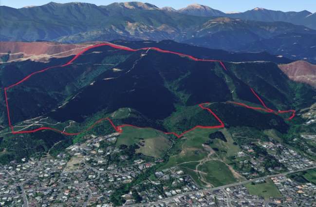
Page |7
3 Project Plan Actions
Important background information to assist in the development of this plan has included:
stormwater modelling of Kingsland Forest under different harvest scenarios
review of property files to identify any legal constraints on the future use of land comprising the forest
survey of current recreational users to gain an understanding of the existing recreational use and views of users and
residents
review of the current information on the Forest, surrounding land use (current and future planning) and approaches taken in
other similar areas, as well as
opportunity for input from iwi and key stakeholders.
Kingsland Forest Development Plan November 2019
Page |8
4 Critical Issues Identified
Stormwater and run off implications are paramount.
Native areas need protection and enhancement/expansion.
Land use selected needs to ‘beat the weeds’ and be practically and financially achievable.
Land use needs to take into account the risks of more intense storm events resulting from climate change.
Both walking and cycling needs to be catered for and not adversely affect each other or the environment.
Need to maximise land use synergies with neighbouring areas.
The Forest currently provides a revenue stream that helps fund forest management, which would not be available under
other options.
Kingsland Forest Development Plan November 2019
Page |9

5     Site Location
                                    Reservoir   Richmond Hill Fire Lookout   Jimmy Lee Creek
                                      Creek                                     Catchment
                                    Catchment

                                  Lodestone                                      Eastern Hill Creek
                                  Catchment                                      Catchment (Wills
                                                                                 Gully)

    Kingsland Forest Development Plan                                                             November 2019
P a g e | 10

6     Current Land Use

Kingsland Forest is one of seven forests held by Tasman District Council for the purpose of generating revenue to reduce the
demand on rates income. Some of the forests are also used for other purposes including recreation (Moturoa/Rabbit Island,
Kingsland, and Tunnicliff) and biosolid disposal (Moturoa/Rabbit Island).
Tasman District Council’s current objective for its forestry portfolio as a whole is to obtain an economic return on investment while
also providing for other environmental benefits.2
There is also an existing policy to spread the risk of its forest resource through various means including planting a mix of species,
with up to 15% by area of species other than Radiata pine. Kingsland Forest currently comprises approximately 92% of its 103 ha
in production forest in Pinus radiata (92%) with smaller areas of Macrocarpa and Cypress comprising 8% of this area. Across the
whole commercial forestry portfolio, 9.5% of the current area is in species other than Radiata.
The recreational use of plantation forests has been formalised through the Recreational Use of Council Plantation Forests Policy
which was finalised in April 2018. This policy provides for the recreational use of Council’s commercial forests within the operational
needs and safety constraints of running a commercial forest and the overriding requirement to protect all other forest values.

2   Forest Management Plan, Tasman District Council 2014-2019
    Kingsland Forest Development Plan                                                                       November 2019
P a g e | 11
7 Neighbouring Land Use
Nelson City Council
Nelson City Council also provides reserves on the Barnicoat Range further to the north in the Marsden Valley area, which connects
to wider Council owned reserves in the Brook, Maitai and Roding valleys. This wider area includes the Brook Waimarama
Sanctuary. Active biodiversity restoration work is underway through the Nelson Nature and Nelson Halo projects.
There is currently also a recreational connection from Kingsland Forest to Marsden Valley via the Barnicoat Range Walkway and
significant opportunities exist to improve the biodiversity connections along the Barnicoat Range between these areas.
Silvan Forest
Silvan Forest is in the process of completing a significant Radiata harvesting operation, and the owners are now looking at a
complete change of land use for this highly accessible and visible forest. Since 2013 the Forest has become a volunteer developed,
non-profit and free access mountain bike park, which has been extremely popular with the local community as a recreational asset.
Due to the steep land, high visibility and proximity to a significant residential population - as well as the ongoing risk from forestry
operations, a large-scale arboretum comprising both natives and exotics is currently being planned for this area. The Forest also
has some native forest remnants in the gullies.
There are clear future synergies between Silvan Forest and Kingsland Forest, both in terms of potential replanting plans and in the
development of links between the two recreation areas.
Other Landowners
Most of the other landowners with land on the Barnicoat Range utilise their landholdings for plantation forestry. Many of these sites
have gullies also containing remnant or regenerating native forest, with scope to act as biodiversity corridors or ‘stepping stones’ for
native wildlife.
There is scope to work together with all these landowners on areas of common interest in forest management and operations.
Kingsland Forest Development Plan November 2019P a g e | 12 The plan also identifies an improvement action to manage runoff from Kingsland to ensure flooding and water quality in Richmond is not affected through good planning of harvesting schedules, replanting and ry practices. Kingsland Forest Development Plan November 2019
P a g e | 13
8 Land Use
Forest Cover
Objectives
Maintain forest cover over the site to
reduce runoff, erosion and sedimentation.
Prevent Emissions Trading Scheme
liabilities and enhance carbon
sequestration from any decisions taken.
Select a regime that permits a variety of
recreational uses of the Forest.
Select species that do not create a wilding
or weed issue.
Current State
Kingsland Forest comprises 103ha of
plantation forest land which is 4% of the total
forest portfolio owned by Council. It is also the
poorest performing forest with an Internal Rate
of Return (IRR) 3 of 5.8%. (Highest being
Moturoa Rabbit Island at 8.1% and an average
of 7.1%).
The reasons for this relatively poor performance despite proximity to log markets is the highly visual location and proximity to a
residential area nearby and extensive recreational use of the Forest. These factors all add cost and complexity to operations.
In the next few years, significant areas of the Forest are scheduled for harvest, including compartment three in the head of the
Jimmy Lee catchment, compartment four on the eastern side of Reservoir Creek and compartment five behind the Lodestone Gully
3
IRR is the rate of return at the net present value over the lifecycle of a project or investment
Kingsland Forest Development Plan November 2019P a g e | 14 several years later. Given the relatively poor performance of this production forest and the range of other values the site is managed for, a review of planting options following harvest is required. Issues Land Use Capability The Land Use Capability handbook and Inventory, first published in 1969, was prepared to provide national standards for the long-term capability to sustain one or more productive uses. Land is categorised into eight classes relating to the land’s capability for use, while taking into account its physical limitations and its versatility for sustained production. The majority of the Kingsland Forest is categorised Class 7, with the lower slopes classified Class 6. As shown in the above table, this land is towards the low end of suitability for production forestry. Both classifications have an ‘e,’ which indicates that erosion is the primary limiting factor. Kingsland Forest Development Plan November 2019
P a g e | 15

Commercial Considerations
As described, Kingsland is the poorest performing forest in the Council portfolio with an Internal Rate of Return (IRR) of 5.8%.
However, this IRR calculation only considers the direct costs associated with the plantation areas and does not include additional
costs associated with managing the non-plantation areas within the Forest. These costs are currently being funded by the
commercial forest account and have included significant weed control costs for the native gullies over the last few years. When
these additional costs are considered, the IRR for Kingsland drops to approximately 2%.
Kingsland generates approximately $2m in net harvesting income every 28 years (at current values), split across several
harvesting cycles. At the return levels highlighted above, Kingsland is not operating as a commercial forest. The only benefit of
having the current plantation areas, over another permanent forest cover, is that the revenue effectively funds forest
reestablishment after harvest and approximately $100-120,000 per year in forestry management costs.4 In the absence of
production forestry continuing on this site, additional funding would be required to resource these activities.

Risk
While the stormwater modelling did not indicate significant additional runoff risk resulting from forest harvesting, risks from
managing slash and silt remain every time harvest and other forest management activities occur. Also, Pinus radiata is more
susceptible than other species to wind and fire damage. A combination of the steepness of the land, residential areas below, high
visibility and climate change generating more extreme and frequent storm and drought conditions are also factors.
The current Council forest management plan has an objective to spread the risk of its forest resource through various means,
including a mix of species throughout all of its forests with up to 15% by area of species other than Radiata pine. Within Kingsland
Forest, only 8% of the planted area is not Pinus radiata and across the whole portfolio this is 9.5%.

Weeds
As experienced following previous harvests and when damage to the areas of native forest has occurred, vigorous weed regrowth
can be expected once a high light environment is created. Desiccation spraying following initial germination of weeds, with a
second follow up application if possible, can assist before planting. It is critical that some form of canopy cover is established as
soon as possible to recreate a low light environment to suppress weed growth after planting. For this reason, evergreens are a
preference in weedy locations. Also, some tree species can become weeds in their own right, as shown in the following table:

4
  Forestry Management Costs comprise a base of approximately $50,000 per year plus between $50,000 and $70,000 per year over the
last few years for weed control
  Kingsland Forest Development Plan                                                                    November 2019
P a g e | 16

                                                       Wilding Tree Risk Calculator5
                 Species                                                                                       Risk
                                                                                                             (0 low, 5
                                                                                                               high)

                 Redwoods, Leyland cypresses, cedars and spruces                                                 0
                 Radiata (P. radiata) and ponderosa (P. ponderosa) pine, Lawsons cypress (C.                     1
                 lawsoniana)
                 Muricata (P. muricata) and maritime (P. pinaster) pine and larches (Larix spp)                  2
                 Corsican (P. nigra) and mountain/dwarf mountain (P. uncinata/mugo) pine                         3
                 Douglas-fir g (Ps. menziesii), Scots pine (P. sylvestris)                                       4
                 Lodgepole/contorta pine (P. contorta)                                                           5

Emissions Trading Scheme (ETS)
To avoid a carbon liability under the ETS, a site must be replanted in a forest and meet reestablishment targets. If native
restoration of a site is selected, it must pass the ‘four years after harvesting test’ which is that each hectare has regenerating forest
species that are likely to survive, grow and continue to germinate, so that the hectare will meet the forest land test 10 years after
clearing. The forest land test is having forest species established that are likely to have a crown cover of 30% or more at maturity.
Forest species include any species that grow to > 5m on the site to achieve a 30% crown cover. In some areas such as those with
enough rainfall and seed source, natural regeneration may be enough providing weeds are controlled - however, in other areas,
supplementary planting of primary cover is likely to be required to meet this target.
Other Factors
Carbon sequestration rates vary between species with exotic hardwoods and softwoods sequestering carbon faster than
regenerating native forest in its early years, however after a several hundred-year process to fully establish, mature native forest
stores more carbon than exotic forests.

5   Calculating Wilding Spread Risk from New Plantings, TS Paul, Scion 2015
    Kingsland Forest Development Plan                                                                         November 2019
P a g e | 17
Pinus radiata is generally harvested on a 28-year cycle which is significantly shorter than some of the slower-growing alternative
species that could be considered. It does, however, have a significantly higher Internal Rate of Return (IRR) than alternative
species, hence the prevalence of this species in the NZ forestry environment.
Given the high levels of public use of the Forest and the associated built infrastructure, including tracks and signs etc. there is
potential for significant disruption and damage during these infrequent periods of harvest.
Some of the compartments on the lower slopes of the Forest, when ready for harvest, may present challenges for access and
safety given their proximity to nearby residential areas. Access and safety will be important considerations for any replanting
decisions, particularly for compartments on the lower slopes.
Key Options and Consideration
Four main options are available for the reestablishment of forest cover following the progressive harvest of the existing tree crop.
These are:
1. Status Quo - Pinus radiata
Replanting the majority of compartments with Pinus radiata and establishing permanent exotic woodland in isolated
compartments on the lower slopes with difficult access or safety concerns.
2. Permanent exotic forest
Replanting compartments with permanent evergreen species such as Redwood (Sequoia sempervirens) and other species
matched to the site.
3. Combination permanent native forest/exotic woodland
Re-establishing native forest on lower compartments and extending native forest in gullies to the ridge using a combination of
active replanting of natives and natural regeneration (while controlling weeds) and replanting remaining mid and upper
compartments with permanent evergreen exotic woodland.
4. Native forest
Re-establishing native forest in all compartments using a combination of active replanting of natives and natural regeneration
(while controlling weeds).
Kingsland Forest Development Plan November 2019P a g e | 18
Assessment of Options against Objectives
Option 1: Option 2: Option 3: Option 4:
Status Quo - Pinus Permanent Exotic forest Combination Native forest
radiata permanent native
forest/exotic woodland
Catchment A shorter period until A longer period than A longer period than Native planting or
Management tree reestablishment Radiata until tree Radiata until tree natural regeneration is
(runoff and and forest cover, reestablishment and reestablishment and the slowest to establish
sediment) although clear-felling forest cover, although forest cover, although forest cover and this
required every 25-30 permanent forest cover permanent forest cover would be over a wide
years. thereafter. thereafter. Native areas area with this option.
slowest to re-establish.
Biodiversity Faster establishment Somewhat increased Biodiversity values able Significant challenges
Restoration period provides a weed threat due to to be enhanced on and costs to achieving
shorter opportunity for slightly slower lower slopes and native native cover rapidly over
weed infestation, establishment rates than gullies extended to the the whole site with
however more risk to Radiata, however ridge. A relatively fast- significant weed
existing native areas permanent forest cover growing permanent smothering risks. The
with production forestry would provide a good exotic cover elsewhere end state of native
adjacent. buffer for existing native would provide good forest would be the best
areas. protection. outcome for biodiversity
but difficult to achieve.
Landscape This option would This option would This option would This option would
Protection achieve the objectives achieve the objectives achieve the objectives achieve the objectives
with more synergies to with more synergies to with more synergies to with more synergies to
the SW privately owned the NE privately owned the NE privately owned the NE privately owned
land. land. land. land.
Bike and Assets would be No future damage to No future damage to No future damage to
Walking severely damaged at assets provided adequate assets provided assets provided
Tracks each harvest. ongoing maintenance. adequate ongoing adequate ongoing
maintenance. maintenance.
Kingsland Forest Development Plan November 2019P a g e | 19
Option 1: Option 2: Option 3: Option 4:
Status Quo - Pinus Permanent Exotic forest Combination Native forest
radiata permanent native
forest/exotic woodland
Cultural and Objectives able to be Objectives able to be Objectives able to be Objectives able to be
Natural Values achieved – although achieved. achieved. achieved.
care needed at harvest.
Fire Prevention Higher flammability Higher flammability Lower risk due to less Lower risk due to less
Control and vegetation with this vegetation with this flammable native flammable native
Safety option although risk option although risk vegetation on lower vegetation on lower
acceptable provided acceptable provided user slopes close to likely slopes close to likely
user safety actions safety actions ignition sources. ignition sources.
implemented. implemented.
Utilities Objectives able to be Objectives able to be Objectives able to be Objectives able to be
Infrastructure achieved. achieved. achieved. achieved.
Costs Lowest cost forest Mid-range cost for forest Higher cost option for Significantly more
reestablishment option reestablishment estimated forest reestablishment expensive option with
estimated at $206,000 at $415,000 over the next estimated at $780,000 forest establishment
over the next 10-year 10-year period. over the next 10-year costs over a 10-year
period. period. period likely to exceed
$3,000,000
Summary Lowest cost option but A relatively low-cost Medium cost option that High cost option with
one that achieves few of option that achieves provides for expansion significant establishment
the objectives. permanent cover of biodiversity risks due to weed threat,
including reduced risk of restoration areas while slope sedimentation risk
sedimentation as well as also achieving etc.
protection of native permanent forest cover, Would result in a better
margins. including reduced risk outcome for biodiversity
of sedimentation and if able to be achieved
protection of native but significantly greater
margins. short-term risks.
Kingsland Forest Development Plan November 2019P a g e | 20
Note: under options 2, 3 and 4 existing Pinus radiata
compartments will be harvested and replanted in non-
commercial trees (exotic species or natives). As this
progressively takes place the funding for replanting costs
and ongoing maintenance will no longer be funded by
future forestry revenue. Rather these costs will be funded
by a combination of Reserve Financial Contributions and
rates. We estimate annual maintenance costs to be in the
order of $170,000 per annum.
Conclusion
Given the range of outcomes that the forest is managed
for, an ongoing cycle of harvest through clear-felling every
25-30 years is disruptive on many of these values. It also
presents a risk to the Richmond community, and the
increased frequency of more severe storm events
resulting from climate change. It is considered that the
multiple non-financial benefits of a permanent forest
immediately behind Richmond to the community outweigh
the financial contribution that this production forest makes
to the Council’s commercial forestry portfolio.
While options 2, 3 and 4 achieve a permanent forest
cover, option 3 is considered most practical, cost-effective
and provides the most benefits for the effort and costs
involved.
Actions
Develop a planting plan that provides for:
o reestablishment of native forest on lower compartments
o the extension of native forest in gullies to the ridge, and
o replanting the remaining mid and upper compartments with permanent evergreen exotic woodland species best suited to
the site.
Kingsland Forest Development Plan November 2019P a g e | 21
Catchment Management
Three primary catchments within Kingsland Forest flow into the residential area of Richmond. These are Jimmy Lee, Lodestone
and Reservoir Creeks. A small area of the forest is also within the Eastern Hill Creek catchment.
In its 2018 Activity Management Plan for stormwater,
the Council signalled an increased focus on integrated
catchment management planning which takes into
account the wider effects on the environment, climate
change effects as well as growth and network
capacity. It seeks to manage the environmental
effects of stormwater discharges by addressing these
as close to the source as possible and to build
capacity for increased frequency and severity of
rainfall events.
Council has developed a catchment management
plan for Richmond, which identifies the importance of
careful forest harvesting schedules, practices and
management within Kingsland Forest as an important
means of managing downstream stormwater effects.
Objectives
Harvesting activities and other land
management activities do not create any
significant increase in flows or sediment load
that will adversely affect the Richmond
streams, urban stormwater and Waimea Inlet.
Water quality and habitats are progressively
improved.
Kingsland Forest Development Plan November 2019P a g e | 22
Current State
Approximately two-thirds of the land within Kingsland Forest is in plantation
forest and one third contains remnant and regenerating native forest. Several
stormwater detention areas exist downstream6, which assist in managing
downstream flows.
Issues
In response to concern regarding the upcoming harvest of significant parts of
the Forest, and the possibility of alternative land uses for parts of the Forest
being considered for the future, Council commissioned a modelling
assessment to determine the possible effects of different harvesting
scenarios in the forest on the catchment below.7
Options
A range of harvesting options was considered in the model, ranging from the
baseline of 0% harvest as at present, to 100% harvest all at one time as well
as in years 2020, 2023, 2035 and 2038 following the current forest harvest
and replanting schedule. In the years between harvesting years, it was
assumed ‘business as usual’ replanting of exotic forest with the
commensurate amount of regrowth for that period. No alternative planting
strategies were considered, although this further analysis was possible if
required.
The modelling found that urban areas of the catchment were observed to be
contributing significant runoff to flooding in Richmond without the influence of
the Kingsland Forest and as such, land-use change in the Forest was
unlikely to impact flood conditions in urban areas of Richmond significantly.
The mobilisation of sediment was, however, determined to be a much more
significant issue that requires effective management. The outcome of
modelling also concluded that short duration storm events proved more
6 Reservoir Creek (Reservoir and Templemore Ponds). Jimmy Lee Creek (Bill Wilkes Reserve, Washbourn Gardens), Lodestone Gully
7 Tonkin and Taylor 2019: Kingsland Forest Stormwater Management, Assessment of Flood effects from Land Uses
Kingsland Forest Development Plan November 2019P a g e | 23
sensitive to any land-use change in the Forest than long-duration storm events.
Of the four catchments draining from Kingsland Forest, Reservoir Creek was considered the most susceptible catchment to
increases in flood hazard to urban areas downstream. This is due to the large size of the catchment, and the absence of substantial
stormwater storage downstream. It was recommended that further modelling of alternative planting and harvesting regimes in the
Reservoir Creek catchment could be investigated.
A high-level finding from the study was that “the introduction of stormwater quantity management measures (e.g. attenuation
devices) in the upper catchment is unlikely to relieve flooding in the urban environment significantly, but that conversely, the poor or
mismanagement of stormwater in the Kingsland Forest can exacerbate downstream flooding issues.” In particular, the way the
forest operations are managed, including the amount of bare ground created and routing of flows via forestry roads, may affect the
range of flood flows resulting from harvesting.
While the stormwater modelling did not indicate significant additional runoff risk resulting from forest harvesting, risks from
managing slash and silt remain every time harvest and other forest management activities occur, given the limitations of
stormwater intakes below. Also, Pinus radiata is more susceptible than other species to wind and fire damage. A combination of
the steepness of the land, residential areas below, high visibility and climate change generating more extreme and frequent storm
and drought conditions are also factors in the risk profile for this site.
Actions
Forestry Practices
Ensure best practice harvest techniques to manage runoff and mobilisation of sediment, including limiting the construction of
new roads and consider debris barriers and further detention areas if required. These actions should be developed and
recorded in the harvest plan following consultation with Council stormwater and parks staff.
Ensure active revegetation of harvested slopes occurs as soon as practicable after harvest using species with good erosion
controlling properties.
Other Activities
Replant additional streamside areas where further shade is required.
Identify any further fish passage obstacles downstream and pursue resolving these.
Kingsland Forest Development Plan November 2019P a g e | 24
Landscape Protection and Enhancement
Objectives
Maintain green forested vista to
Richmond Hill from Richmond, south
Nelson and the Waimea Plains.
Look for opportunities for a common
theme along the Barnicoat Range.
Provide opportunities within the
Forest for views across the Waimea
Plains and Tasman Bay.
Current State
The Kingsland Forest is located on the
Barnicoat Range, which forms the
primary backdrop to the Richmond and
South Nelson area. The whole range is
relatively steep with a cover dominated
by plantation forestry with areas of scrub,
grassland and pockets of remnant native
vegetation.
These mixed vegetation types contribute to a ‘green’ backdrop to the Nelson Richmond area. The lower slopes of Kingsland Forest
also have network utility assets, including power transmission lines and telecommunication repeaters and water reservoirs. It is
expected that some further expansion and infilling of the residential area on the lower slopes will also occur over time.
Issues
The Barnicoat Range comprises several different landowners, resulting in the mix of land uses that we see today. Plantation
forestry is likely to remain the dominant land use along the range although some landowners are currently considering alternative
species partly to reduce the raw impact on the landscape that occurs on the harvest of Pinus radiata at 25-30-year intervals
Further potential threats to landscape values include scarring from earthworks for tracks for forestry or other land uses,
development of further buildings, or utility structures in prominent locations.
Kingsland Forest Development Plan November 2019P a g e | 25
Options
Providing some form of forest reestablishment regime is selected, there are several options that will ensure that the green backdrop
to Richmond is maintained. From a pure landscape perspective, a forest that does not require clear-felling as part of harvesting is
preferable, however this also means a loss of revenue. There is value in considering land uses adjacent both in terms of seeking
synergies in planting design and practical operational matters such as access and forest management activities.
As there is already a strong presence of network utility assets, on the lower slopes of the Forest, any further development should
preferably be located within the existing areas of modification rather than in new locations.
Users of the Forest also value viewpoints and view shafts being maintained to be able to appreciate the spectacular views across
the Waimea basin and Tasman Bay. Not every user is able to reach the summit of Richmond Hill itself, therefore maintaining
several other key view shafts from the Forest in key locations is desirable.
Actions
Ensure forest is re-established on the site to ensure a green backdrop to Richmond is maintained.
Where there is alignment in aspirations for landscape development with neighbouring properties, consider a common approach
to achieve a wider positive landscape effect.
Seek to limit new network utility assets to existing areas.
Create and maintain a selection of viewpoints within the walking and biking track network .
Kingsland Forest Development Plan November 2019P a g e | 26
Cultural, Historical and Archaeological Values
Objectives
Manawhenua iwi are suitably acknowledged for their customary use of these catchments and waterways being ara (trails)
inland to areas of harvest and opportunities to work in partnership with the Council on the development of the Forest are
available.
Rongoā/medicinal species and species used for other Māori customary purposes (such as for rāranga/weaving) form part of the
landscaping of parks and reserves and are available for sustainable harvest.
Historical, cultural and archaeological sites are protected and interpreted where appropriate.
Current State
Council is building its partnership relationship with manawhenua iwi in Te Tau Ihu through its planning and day to day operational
activities. The objective is to ensure te ao Māori (the Māori world view) is represented in the way Council undertakes its statutory
and wider role for the community. While the area of land comprising the Forest was not considered to have been sites of
occupation, Māori would have travelled through this area inland to areas of harvest.8
Actions
Ensure the manawhenua iwi association with the land and partnership with Council is reflected on any new signboards for the
reserve.
Rongoā/medicinal species and species used for rāranga/weaving form part of the planting plans for native restoration areas
and are available for sustainable harvest for use.
As a registered historic site, Reservoir Creek dam is protected and interpreted.
8 Māori cultural site review, Te Atiawa Trust, 2019.
Kingsland Forest Development Plan November 2019P a g e | 27
Biodiversity Restoration
Objectives
Maintain and enhance existing
conservation values and actively
manage identified threats.
Ensure weed and pest management
activities are adequately resourced to
support restoration objectives.
Current State
Kingsland Forest contains three gullies
containing remnant and regenerating native
forest. These are within the Jimmy Lee
(14.8ha), Lodestone (4ha) and Reservoir
Creek (26.5ha) catchments.
These forest remnants contain a range of
native vegetation communities such as gully
forest rich in titoki, mahoe, pigeonwood and
tawa, which is considered a rare community
in Bryant Ecological District.9 Regenerating
pole matai also occur in the upper
catchments.
Scattered large podocarps within the
reservoir creek catchment, including
kahikatea and totara, are notable trees within
the Bryant ED. The Native Habitats Tasman
programme considers the site is the best
remaining example of gully forest on the
northern faces of the Barnicoat Range.
9 Native Habitats Tasman Ecological Assessment Report, Michael North 2012
Kingsland Forest Development Plan November 2019P a g e | 28
The main gully bottom of mixed broadleaved forest associations is in good condition primarily as a result of extensive efforts by
volunteers undertaking weed control, pest control and supplementary planting however extensive areas of climbing weeds exist
around the margins of the Forest where light levels are higher.
In recent years anecdotal evidence also suggests an increase in birdlife including tui, korimako (bellbird), riroriro (grey warbler),
piwakawaka (fantail), pihipihi (waxeye) and pīpīwharauroa (shining cuckoo) over the summer months. Ruru (morepork), kotare
(kingfisher), kereru (NZ pigeon), pipipi (brown creeper) and occasional karearea (NZ falcon) are also present. As with other areas in
the Nelson Tasman area, weka has also returned in large numbers to the Forest.
Issues
While these forest remnants have been retained through the care and ongoing efforts
by past and present landowners, they are still under significant threat from weeds,
pests and adjacent forestry activities.
Old man’s beard and banana passionfruit are well established within all of the
catchments, with the Reservoir Creek bush margins in particular also heavily infested
with climbing alstromeria (Bomarea multiflora). Weed infestations are generally low or
scattered within the lower light valley floors however at the margins they are extensive
in places. Other weeds within the Forest include barberry, gorse, hawthorn, Himalayan
honeysuckle, woolly nightshade and climbing spindleberry. Mature macrocarpa and
radiata pine are also scattered along the margins in the lower section of the site.
Extensive predator and possum trapping by dedicated volunteers occur within these
areas, which keeps numbers at acceptable levels. Pigs and goats are occasionally
seen but given the large amount of human activity in the Forest, these only cause
localised problems from time to time.
Forest operations immediately adjacent to these native remnants have in the past
resulted in damage, particularly at harvest where trees have damaged the bush
margins - creating conditions that favour old man’s beard and banana passionfruit
establishment. Earthworks and runoff from logging roads and skid sites have also
caused significant damage. Improved harvest techniques are now able to avoid
damage to adjacent areas, although an exposed forest edge and sedimentation risk remains following harvest and requires active
management.
Kingsland Forest Development Plan November 2019P a g e | 29
Options
Council has a role in encouraging the protection and enhancement of areas of significant natural value within the District 10. For
areas of land directly owned and managed by Council, this is particularly important. Many of the threats to the protection of the
Forest relate to edge effects either through forestry activities or by weed invasion around high light areas of the margins.
Withdrawing production forestry from these edges and replacing it with suitable fast-growing native or exotic species to provide
primary canopy cover as fast as possible is likely to be the best option both to suppress potentially vigorous weed regrowth and
provide a nursery cover for other species.
Given the proximity of the Forest to other Native Habitats Tasman sites11 and wider forested habitats (including the Brook
Sanctuary and Nelson Halo project), there is an advantage in connecting these existing habitats to the ridge as well as to the
residential areas of Richmond to provide a corridor for wildlife movement.
Actions
Harvest practices are undertaken using techniques that minimise damage to areas of native forest in the gullies and adjacent
flanks.
Biodiversity corridors are developed to link existing native gullies from the top of the Barnicoat Range to the backyards of urban
Richmond.
Continue to develop a band of native vegetation on lower slopes by not replanting exotics in lower compartments.
In conjunction with recreational track development objectives, provide access tracks around the edge of native forest areas to
provide for good access for weed (and pest) control activities.
Maintain an active weed and pest control programme to prevent damage to forest values and forest reestablishment.
Work with volunteer groups to better define biodiversity objectives for the important work that they do and establish robust
monitoring to measure results and advocate for the work being undertaken.
Work with adjoining landowners to encourage control of invasive weeds such as woolly nightshade.
10
Resource Management Act 1991, Sections 5,6 and 7
11 Refer Appendix 6
Kingsland Forest Development Plan November 2019P a g e | 30
Fire Prevention, Control and Safety
Objectives
Recreational users are not placed in an unsafe situation when within the Forest.
Council actively manages its landowner fire and safety management obligations.
Current State
As with other recreation areas in the Nelson Tasman region, Kingsland Forest presents a
risk for users during periods of dry weather. This risk is due to a large area of available
flammable vegetation in the same location where walking and cycling are occurring with
potential ignition sources below on the fringe of the Richmond residential area.
Issues
Some of this risk is unable to be easily resolved due to the location of the Forest immediately
behind and uphill from Richmond. However, there are several land management practices
that will assist in managing these risks.
Options
Fire and Emergency NZ (FENZ) is the primary organisation responsible for managing fire
risk throughout the District. For Kingsland Forest, a Recreational Area Fire Management
Plan has been developed by FENZ that will guide both landowner and user actions to reduce
the risk of fire, provide safe areas and clear actions to take in the event of a fire.
Actions
As recommended in the FENZ Recreational Area Fire Management Plan.
Placement of signs at entry points to the Forest with steps to take in case of a fire and
the installation of markers at designated safe areas.
Consider using broadleaf natives and species with low flammability alongside tracks.
Regular maintenance of designated safe areas to remove vegetation to make these sites suitable as an evacuation point.
Work with FENZ on closing public access to the Forest during periods of high fire risk.
Kingsland Forest Development Plan November 2019P a g e | 31
Utilities Infrastructure
Objectives
To ensure land-use decisions within
Kingsland Forest do not adversely affect
critical utilities infrastructure.
Current State
Safe corridors are currently in place around all
network utilities infrastructure. In some areas,
inappropriate species close to the power line
corridor have been replaced by lower growing
natives to achieve this.
Issues
The presence of network utilities infrastructure
places limitations on the range of uses possible
in this part of the Forest - however, it is important Cellphone Tower
that this infrastructure is protected as a priority.
Options
The most effective way of managing risk is to
create safe setbacks at the time of planting.
Transpower is available to assist this planning
with setback mapping and on the ground
guidance.
Actions
Corridor setback requirements are taken into
account in the development of planting plans.
Kingsland Forest Development Plan November 2019P a g e | 32 Kingsland Forest Development Plan November 2019
P a g e | 33
9 Recreational Use
Overall Objectives
Provide well signposted and easy to use entrances to the Forest and ensure information about recreational opportunities in the
Forest is readily available.
Actively provide for both walking and biking and a range of different grade tracks for a variety of abilities.
Use activity zones, shared use and designated trails to reduce the potential for conflict between walkers and bikes.
Ensure hubs and intersections are clearly signposted.
Provide for wider connections to other public recreation areas.
Ensure that new track building activity only occurs where current and projected use levels warrant it and that it is within the
carrying capacity of the catchment in order to reduce the risk of erosion, land stability, or sedimentation issues.
Existing Policy Provisions
The Forest access policy12 provides for free access for walkers, runners and cyclists to the forests over formed and signposted
tracks or roads with a passive and informal outdoor recreation emphasis. It also provides for use of pedal-assisted ebikes with a
maximum power not exceeding 300W. Organised events are provided for within Council forests, subject to an application and
approval process. The Policy specifically reinforces that the building of new tracks, alteration of existing tracks or other recreational
infrastructure by any other party is not permitted in the forests without the prior approval of the designated Council officer.
Overall Recommended Actions
Seek opportunities to increase the number and quality of entrance points into the Forest.
Review track naming, signage and wayfinding hierarchy to ensure necessary information is available at each intersection and
align between GIS records.
Take into account activity zones when planning for new track development.
Seek geotechnical advice before construction of new tracks that require earthworks in sensitive areas.
12 Recreational Use of Council Plantation Forests, April 2018
Kingsland Forest Development Plan November 2019P a g e | 34 Follow best practice guidelines when constructing, modifying and maintaining tracks.13 Retain forest roads as shared-use tracks. Consider options to improve base facilities at Easby Park including improving car parking and toilets for Kingsland Forest users. 13International Mountain Bicycling Association (IMBA) Guide to Building Sweet Single Track, New Zealand Standard HB 8630:2004 Tracks and Outdoor Visitor Structures Kingsland Forest Development Plan November 2019
P a g e | 35
Mountain biking
Objectives for Mountain biking
Provide a range of consistently graded and well-signposted trails for a range of
users with a focus on the north-eastern side of the Forest.
Ensure the number and location of tracks provided over time does not adversely
affect other forest values.
Ensure sufficient resourcing is in place to maintain existing trails before new trail
development is considered.
Current State
While there are currently a number of mountain bike tracks in the Forest, there is a need to
more cohesively integrate these into the wider network and provide some key linkages.
Much track building has historically occurred informally without following a wider plan.
Parts of the Forest are currently difficult to access for bikes - however, this has enabled a
level of separation between pedestrian and bike focussed parts of the Forest, although the
exception to this is the intensively used Easby Park entrance area.
Options
Feedback received from the mountain biking community has reinforced the importance of
providing a range of trails of different mountain biking grades, as shown in the below table.
While difficult to achieve in hilly environments, the provision of high-quality grade two and
three trails is particularly important for new riders and families. A high-quality well-graded
climbing track is key to this provision.
Kingsland Forest Development Plan November 2019P a g e | 36 Kingsland Forest Development Plan November 2019
P a g e | 37

                                                                                         Upper
                                                                                        Reservoir
                         Proposed
                                                               Escalator                  Creek
                         Current                             Hang 10                         Hang 10
                                                               Extension                traverse
                                                            Extension                       Extension

                                                                                                  Escalator
                                                                                                Improvement

                                                  Escalator
                                                Improvement

                                                 Upper
                                                Reservoir
                                                 Creek
                                                Traverse

                                    Escalator
                                    Extension

Kingsland Forest Development Plan                                November 2019
P a g e | 38 Actions Realignment of the Escalator climbing track to ensure 6 degrees is maintained and extend to the top of the Forest. Extension of Hang 10 to provide grade 3 access out to Easby Park to allow for Escalator to be solely one way. Explore options to provide separate bike access to the reservoir (and eastern Reservoir Creek flanks). Develop a new trail around the margin of the native area of Reservoir Creek to link with the Silvan Forest boundary. Consider options for longer cross-forest return loop from the top of the extended Escalator. Provide a range of other downhill tracks of different grades within environmental constraints as demand warrants. Prevent mountain bike use of valley floor tracks in the native gully areas of Jimmy Lee, Reservoir Creek and Wills Gully Kingsland Forest Development Plan November 2019
P a g e | 39
Walking
Objectives for Walking
To provide a range of return loop walking options for different abilities from each
entry point as well as high, mid and low-level traverses of the Forest.
Current State
There are five main entry points to the Forest via adjacent reserve land of Easby
Park and Dellside Reserve.
Will’s Gully/Eastern Hill Creek from Hill Street south.
Jimmy Lee Creek from Hill Street via Jimmy Lee Creek Reserve.
Valhalla Drive via Dellside Reserve.
Lodestone Road via Dellside Reserve.
Marlborough Crescent/Cropp Place via Easby Park.
From each of these access points, a range of walking opportunities are currently
available, including the use of forestry roads, and in some cases, tracks also
developed for mountain biking.
Issues
Historically walkers within the Forest have used the forestry roads, however many of
these are steep in places and present difficulties for some users.
With the growth in mountain biking around the region and higher levels of volunteer
capacity to construct tracks, parts of the Forest are dominated by mountain bike
tracks. The south western parts of the Forest have a lower intensity of mountain bike
tracks, due to access points to the area being less bike-friendly and a bike
prohibition on the Jimmy Lee track.
Options
The primary tool that provides a consistent framework for the design, construction,
maintenance and management of tracks and outdoor visitor structures in New Zealand
is the handbook: Tracks and Outdoor Visitor Structures (SNZ HB 8630:2004). This
standard identifies a set of six main categories that cater for corresponding visitor
groups to parks and reserves.
Kingsland Forest Development Plan November 2019P a g e | 40
Track categories
Track classification Features Visitor group
Path Well-formed on a durable surface such as concrete, chip seal, asphalt or Urban
compacted gravel. Easy walking, mostly in urban settings, and for all ages Residents
and most fitness levels. Many will cater for people with mobility (UR)
difficulties.
Short Walk Well-formed. Up to 1 hour’s easy walking (return). Suitable for most ages Short Stop
and fitness levels. All watercourses are bridged. Some may cater for Travellers
people with mobility difficulties. (SST)
Walking Track An extended walk that takes from a few minutes to a full day return. Day Visitors
Suitable for relatively inexperienced people with a low level of backcountry (DV)
skill. All but the smallest watercourses are bridged.
Tramping Track Generally multi-day tramping track catering for relatively inexperienced Backcountry
Great Walk backcountry trampers. Well-constructed tramping track with a track surface Comfort
Easy Tramping and bridges across rivers and major streams. Seekers
Track (BCC)
Tramping Track Marked tramping track that generally follows the lie of the land and is Backcountry
commonly not formed. May be multi-day or backcountry tracks taking less Adventurers
than a day. Key river crossings are bridged. (BCA)
Route Generally unformed, lightly cut route catering for the most experienced of Remoteness
backcountry visitors. Routes follow the lie of the land and are not formed. Seekers (RS)
(Table 2 SNZ HB 8360: 2004)
Of these the Short Walk, Walking Track and Easy Tramping Track categories are most relevant to consider for tracks within the
Forest.
Kingsland Forest Development Plan November 2019P a g e | 41 Kingsland Forest Development Plan November 2019
P a g e | 42
Actions
Develop a new track to bypass Cypress Road at a better gradient
Provide a connection track back to Valhalla Track from Allans Gully Track, and
Extend Reservoir Creek track to the ridge.
Utilise forestry road extension, if constructed, for walking to connect Heaton Road to Oliver Road.
Review gradients of the forestry roads to determine if they meet necessary standards for use as walking tracks and easy
tramping tracks and consider developing bypass tracks on steeper sections.
Consider bridges for the lower Jimmy Lee and Reservoir Creeks.
Kingsland Forest Development Plan November 2019P a g e | 43 Dog Walking Objectives There are places in Kingsland Forest where dogs are permitted. There are no adverse effects on other users, wildlife and other values. Current State The Dellside Reserve, including track up into Richmond Hills, is currently identified as a dog exercise area within the Dog Control Bylaw 201414. Within a dog exercise area, every dog “shall be kept under the effective control of a responsible person, responding to voice commands, whistles, hand signals, or other effective means.” Also, “on any occasion a dog is likely to injure, endanger, or cause distress to any stock, poultry, domestic animal or protected wildlife, it shall be kept under continuous leash control. “ 15 The area is very popular with dog walkers given its proximity to Richmond but is also home to an increasing amount of native wildlife (including weka) that is vulnerable to uncontrolled dogs. Issues While some dog owners would have ‘effective control’ over their dogs, many others would not meet this definition. While the current bylaw is not definitive, it seeks to strike a balance of discouraging owners that are unable to adequately control their dog, while not unreasonably restricting those that can. Options It would be difficult and a potentially excessive approach to require all dogs on leads in all locations within Kingsland Forest, given the popularity of this activity. It is also difficult to accurately identify specific areas that are particularly vulnerable to dogs, given that weka can occur throughout the exotic part of the Forest, as well as in the native area. 14 Tasman District Council Consolidated Bylaw, Chapter 2 15 Dog Control Bylaw, Schedule 2 Kingsland Forest Development Plan November 2019
You can also read