Transportation Improvement Program for the OCARTS Transportation Management Area
←
→
Page content transcription
If your browser does not render page correctly, please read the page content below
Preliminary
   Transportation Improvement Program
             for the OCARTS
     Transportation Management Area

                       FFY 2018 - FFY 2021
                    (October 1, 2017 - September 30, 2021)

                          Association of Central Oklahoma Governments
                                    4205 N. Lincoln Boulevard
                                    Oklahoma City, OK 73105
                               Telephone: (405) 234-ACOG (2264)
                                       Fax: (405) 234-2200
                                         www.acogok.org

            Adopted by the Intermodal Transportation Policy Committee
                  and Endorsed by the ACOG Board of Directors
                                        on ____________

             Approved by the Oklahoma Department of Transportation
                                        on ___________

Preparation of this report was financially aided through funds provided by the U.S. Department of
Transportation (Federal Highway Administration and Federal Transit Administration), the Oklahoma
Department of Transportation and local contributions.
Preliminary FFY 2018-FFY 2021 TIP for the OCARTS TMA

TABLE OF CONTENTS
INTRODUCTION............................................................................................................................................. 1

OVERVIEW OF PROGRAM ELEMENTS ......................................................................................................... 7

STREET AND HIGHWAY ELEMENT ............................................................................................................ 11
           (Includes Proposed Pedestrian and Bicycle Improvements)

           FFY 2018 Local Government Projects ........................................................................................ 19
           FFY 2018 ODOT Projects and OTA Projects ............................................................................... 21

           FFY 2019 Local Government Projects ........................................................................................ 25
           FFY 2019 ODOT ........................................................................................................................... 27

           FFY 2020 Local Government Projects ........................................................................................ 31
           FFY 2020 ODOT Projects ............................................................................................................. 33

           FFY 2021 Local Government Projects ........................................................................................ 36
           FFY 2021 ODOT Projects ............................................................................................................. 37

TRANSIT ELEMENT .................................................................................................................................... 40

           Urbanized Area Program (COTPA and CART) .............................................................................. 40
           Elderly and Persons with Disabilities Program ........................................................................... 49
           Public Transportation Program for Rural Areas ......................................................................... 50

AIRPORT ELEMENT ................................................................................................................................... 53

           Will Rogers World Airport ............................................................................................................. 54
           Wiley Post Airport ......................................................................................................................... 55
           Clarence E. Page Airport .............................................................................................................. 56
           Max Westheimer Airport .............................................................................................................. 57
           David J. Perry, Guthrie-Edmond Regional, and Purcell Municipal Airports............................... 57

ADOPTING RESOLUTION ........................................................................................................................... 58
MPO SELF-CERTIFICATION........................................................................................................................ 59

APPENDIX A             Public Involvement Documentation ............................................................................... 60
APPENDIX B             Authorization for ODOT to act as Governor’s Designee ................................................ 61
APPENDIX C             Anticipated Suballocation of STP-UZA Funds ................................................................ 62

                                                                        Page i
Preliminary FFY 2018-FFY 2021 TIP for the OCARTS TMA
TABLES AND FIGURES*
TABLE 1 OCARTS Area Projects Funded During FFY 2016 ....................................................... 13
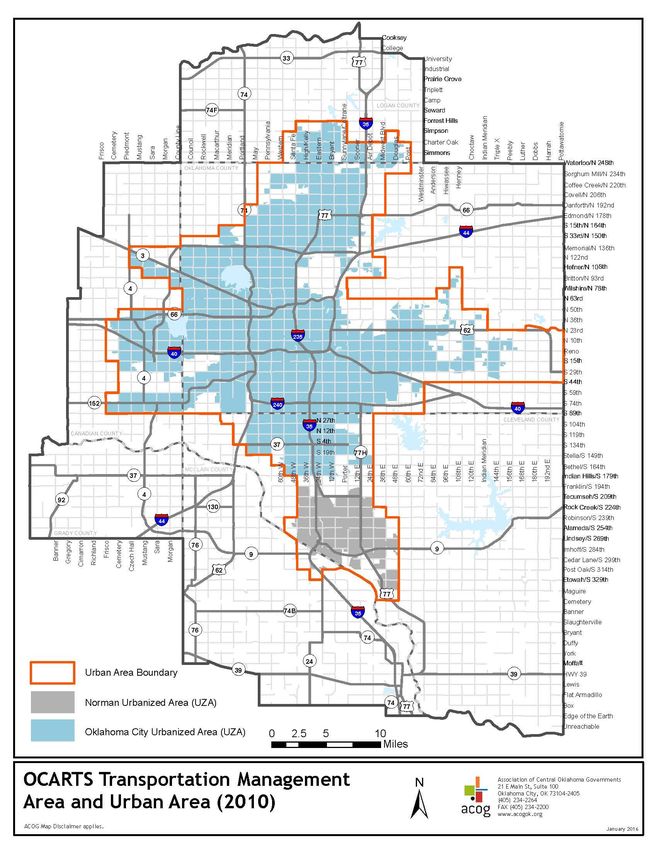
FIGURE 1 OCARTS Transportation Management and Urban Areas .............................................. 3
FIGURE 2 Major Improvements Funded During FFY 2016 ......................................................... 15
FIGURE 3 FFY 2018-2021 OCARTS Area STP-UZA Projects ....................................................... 39
*Maps/data presented in this report were created and assembled by the Association of Central Oklahoma Governments (ACOG) for
information, planning reference and guidance only. You are admonished to use these materials only as a starting point and not a final
product or document. None of these materials should be utilized by you or other parties without the benefit of advice and instruction from
appropriate professional services. These materials are not verified by a Registered Professional Land Surveyor for the State of Oklahoma
and are not intended to be used as such. ACOG makes no warranty, express or implied, related to the accuracy or content of these
materials and data.
Page iiPreliminary FFY 2018-FFY 2021 TIP for the OCARTS TMA
INTRODUCTION
Background
The Transportation Improvement Program (TIP) is a cooperatively developed four-year program
outlining multimodal transportation improvements and services to be implemented within the
Oklahoma City Area Regional Transportation Study (OCARTS) area.
Federal law requires that all Metropolitan Planning Organizations (MPOs) prepare a TIP for their
designated region. The Fixing America’s Surface Transportation (FAST) Act is the most recent law
establishing federal transportation policy and funding authorizations. Under this legislation, the
Association of Central Oklahoma Governments (ACOG), in its role as the MPO, is responsible for
preparing the regional Transportation Improvement Program (TIP) in cooperation with the state
department of transportation, transit operators and local governments.
Although federal regulations require the TIP be updated at least every four years and cover a
minimum four-year period, ACOG produces a new TIP triennially and outlines federal transportation
expenditures for the subsequent four-year period. This document is prepared under the guidance of
the Intermodal Transportation Technical and Policy Committees, and is submitted to the Governor,
the Federal Transit Administration (FTA), and the Federal Highway Administration (FHWA) through the
Oklahoma Department of Transportation (ODOT).
Capital and non-capital projects funded by the Federal Transit Administration, the Federal Highway
Administration, and the Federal Aviation Administration are required to be listed in the TIP to be
eligible for obligation of federal funds. Projects designated for each year of the TIP are expected to
be ready for obligation of federal funds within the year listed. Other state, county, and locally funded
projects may also be included in the TIP for informational purposes.
TIP Purpose and Scope
The TIP is intended to fulfill the following purposes:
To serve as a short-range implementation tool to achieve compliance with the goals of the regional
long-range transportation plan.
To provide continuity of current transportation improvement projects with those identified in
previous TIPs.
To identify transportation projects recommended for implementation by transportation mode, type
of improvement, funding source(s), and geographic area.
To estimate the costs of projects proposed for federal funding. The total federal share of project
costs is to be consistent with the federal funds reasonably anticipated to be available for such
projects in the area.
To establish a prioritization of projects to effectively utilize federal funds as they become available.
To identify and implement transportation improvements which will reduce congestion, increase
mobility and safety, and enhance the region's air quality.
Page 1Preliminary FFY 2018-FFY 2021 TIP for the OCARTS TMA
Prioritization of Projects
This TIP includes a listing of projects for FFY 2018, 2019, 2020 and 2021. Those projects included
in FFY 2018 are considered to be of the highest priority and most ready for implementation. This
means that local matching funds have been identified, environmental review and site preparation for
construction projects have been, or will be, accomplished within the funding period, and the project
is anticipated to result in the obligation of federal funds during FFY 2018. Projects for future
implementation and of lesser readiness are those identified in the subsequent fiscal years. The
projects included in this TIP represent the priorities of the Metropolitan Planning Organization for
implementation within the OCARTS area. All projects included in the TIP are consistent with the
region’s Metropolitan Transportation Plan, Encompass 2040, adopted on October 27, 2016, and the
Oklahoma Long-Range Transportation Plan 2015-2040, approved November 2016.
Program Boundary
The geographic area covered by the TIP is coterminous with the metropolitan planning boundary,
known as the Oklahoma City Area Regional Transportation Study (OCARTS) area. The OCARTS area
includes approximately 2,085 square miles, which encompasses all of Oklahoma and Cleveland
Counties and portions of Canadian, Grady, Logan, and McClain Counties1. The OCARTS area is also
designated as the Transportation Management Area (TMA) for the Oklahoma City metropolitan
region.
Beginning with the 2000 census and continuing with the 2010 census, the U.S. Census Bureau
delineated two urbanized areas (UZAs) within the OCARTS TMA—the Oklahoma City UZA and Norman
UZA. Sec. 6016 of the FAST Act attributes the Norman UZA population to the Oklahoma City UZA for
highway funding purposes. These boundaries are important because they directly impact the amount
of funding that is suballocated to the MPO for project selection. Only UZAs with a population of at
least 200,000 receive suballocated federal funds under certain FHWA programs, which the Norman
UZA would not qualify for on its own. However, the FTA does distribute funding to designated
recipients for both large and small urbanized areas.
Figure 1 reflects the latest geography of the Oklahoma City and Norman urbanized areas, as well as
the adjusted, or “smoothed”, urban area boundary (UAB) within the OCARTS TMA.
1The Intermodal Transportation Policy Committee approved the current OCARTS area boundary on February 28, 2002, which
added 395 square miles in McClain and Cleveland Counties.
Page 2Preliminary FFY 2018-FFY 2021 TIP for the OCARTS TMA
Figure 1: OCARTS Transportation Management Area and Urban Area
Page 3Preliminary FFY 2018-FFY 2021 TIP for the OCARTS TMA
Program Revisions
Projects included in the TIP may be considered for amendment or revision. Such amendments may
not exceed the federal, state and local funds anticipated to be available in order to maintain the
FAST Act financial constraint requirement for the TIP. Modifications to the TIP requested by OCARTS
area communities or other implementing agencies must have the approval of the ITPC, which
conducts a public hearing prior to final action. Following MPO approval, each amendment is
forwarded to ODOT for approval, as the Governor's designee, and inclusion in the Statewide
Transportation Improvement Program (STIP).
Air Quality and Conformance with SIP
The impact of transportation on Central Oklahoma's quality air is a component of ACOG's regional
planning efforts. Since the establishment of comprehensive federal and state emission regulations
by the 1970 Clean Air Act, research has continued to demonstrate the relationship between public
health and air quality. While ACOG is not a regulatory body and has no enforcement capabilities, it
does work to promote compliance with the Environmental Protection Agency's (EPA’s) National
Ambient Air Quality Standards (NAAQS) through a variety of programs in Central Oklahoma.
In October 2015, EPA revised the primary and secondary ozone standard levels from 0.075 parts per
million (ppm) to 0.070 ppm, and retained their indicators (O3), forms (fourth-highest daily maximum,
averaged across three consecutive years) and averaging times (eight hours). The new standards
have been challenged in court by a number of states and industry groups which could possibly delay
or suspend the new standards. Prior to these challenges, EPA had projected final designations and
classifications to be determined by October 2017.
Although the OCARTS area is in compliance with the federal air quality standards, regional leaders
continue to explore strategies that will maintain and improve our air quality. ACOG works in concert
with a multitude of stakeholders on air quality related activities with a particular focus on ground-
level Ozone and Carbon Monoxide. These emissions reductions efforts are reported to EPA annually
as part of EPA’s Ozone Advance Program. Central Oklahoma must remain vigilant in promoting good
air quality habits if we are to remain in compliance in the future.
More information about Central Oklahoma’s air quality status and the region’s efforts to remain in
attainment with the National Ambient Air Quality Standards can be found online at www.acogok.org.
Title VI and Environmental Justice
Title VI of the 1964 Civil Rights Act (42 U.S.C. 2000d-1) states that "No person in the United States
shall, on the grounds of race, color, or national origin, be excluded from participation in, be denied
the benefits of, or be subjected to discrimination under any program or activity receiving federal
financial assistance." The Environmental Justice (EJ) Orders (1997) further amplify Title VI by
providing that "each federal agency shall make achieving environmental justice part of its mission by
identifying and addressing, as appropriate, disproportionately high and adverse human health or
environmental effects of its programs, policies and activities on minority populations and low-income
populations."
Compliance with Title VI and the EJ Orders among recipients of Federal Highway and Federal Transit
Administration funds is a priority of the U.S. Department of Transportation that is evaluated during
metropolitan and transit authority certification reviews and review of the Statewide TIP.
In compliance with FTA Circular 4702.1B, the Central Oklahoma Transportation and Parking
Authority (COTPA) and Cleveland Area Rapid Transit (CART) jointly prepare triennial Title VI reports
documenting that transit services and amenities are provided within the region in a
nondiscriminatory manner. ACOG’s Title VI Plan further documents that the MPO planning process,
Page 4Preliminary FFY 2018-FFY 2021 TIP for the OCARTS TMA
including information dissemination and participation in the decision-making process, is conducted
in a nondiscriminatory fashion.
Projects included in this TIP represent a balance between transportation needs and anticipated
funding. Projects are generally dispersed throughout the OCARTS area, and different improvements
affecting different locations are identified each time a new TIP is prepared. Impacts on various
socioeconomic groups from large projects that address transportation corridors or modes are
generally determined through special planning studies or environmental processes prior to inclusion
in the TIP and STIP. Smaller projects to improve the capacity or safety of the existing street network,
the transit system or area airports are not anticipated to have a disproportionate impact on any
particular segment of the region's population.
Performance Management
The FAST Act and its predecessor, Moving Ahead for Progress in the 21st Century (MAP-21), require
that states and MPOs conduct performance-based planning. The objective is to invest resources in
projects that will collectively progress toward the achievement of national goals. The legislation
requires the U.S. Department of Transportation, in consultation with states, MPOs and other
stakeholders, to establish performance measures in these areas:
• Safety
• Infrastructure condition
• Congestion reduction
• System reliability
• Freight movement and economic vitality
• Environmental sustainability
• Reduced project delivery delays
The TIP, as well as the Metropolitan Transportation Plan (MTP), are required to address the region’s
established performance measures. Guidelines for several of the federal requirements are still under
development, as are specific performance measures and targets for the OCARTS area. As these are
more fully developed, performance-based planning will be integrated into the MPO’s processes for
MTP and TIP project selection.
Public Involvement
ACOG’s public participation goals and strategies are outlined in its Public Participation Plan. This
document acts as a framework from which to guide the public participation process in transportation
planning, including development of the TIP.
In developing this TIP, the MPO provided citizens, affected public agencies, local governments, public
and private transportation providers, goods movement providers, and other interested parties with a
reasonable opportunity to provide input and to comment on the proposed program. Opportunities for
review and comment on the proposed TIP were announced through articles and notices published in
metro area newspapers, ACOG's e-newsletter, Perspective on Central Oklahoma, and public
meetings/hearings held by the Intermodal Transportation Technical Committee (ITTC) and the
Intermodal Transportation Policy Committee (ITPC).
Notices of public hearing were published in local newspapers advising the public of the availability of
the preliminary and final versions of the FFY 2018-2021 OCARTS area TIP. Notices included
information on the time frame for submitting written comments and the date, time and location that
the TIP would be considered by the Intermodal Transportation Policy Committee. In addition,
notification was provided via the ACOG website, a media release, and ACOG’s social media suite.
Appendix A includes documentation of the MPO’s public outreach efforts associated with this TIP.
The final TIP and subsequent amendments will be available on ACOG’s website.
Page 5Preliminary FFY 2018-FFY 2021 TIP for the OCARTS TMA
Comments on this TIP from the public, committee members, or any local organization, whether positive or
negative, are handled in the following manner:
All comments are requested to be put in writing and provided to the MPO.
Comments concerning specific projects or proposals are forwarded to the sponsoring agency or
jurisdiction.
A copy or summaries of substantive comments are provided to the ITTC and ITPC during their regular
meetings for their evaluation.
A written response is provided to the individual or organization concerning recommendations or decisions
arising from the ITPC meeting or the sponsoring entity, as appropriate.
Copies of all comments received on the preliminary TIP are included in the final document.
Page 6Preliminary FFY 2018-FFY 2021 TIP for the OCARTS TMA
OVERVIEW OF PROGRAM ELEMENTS
Street and Highway Element
The Street and Highway Element of the TIP includes transportation improvements submitted by cities
and counties located within the OCARTS area, as well as projects recommended for funding within
the OCARTS area by the Oklahoma Department of Transportation (ODOT). Funding for these projects
will utilize a variety of federal funding categories administered by the Federal Highway
Administration. Each of the Street and Highway Element projects represent short-range priorities that
are located on the Federal Functional Classification System and are consistent with the region’s
long-range transportation plan, Encompass 2040, and the Oklahoma Long-Range Transportation
Plan. Encompass 2040 was adopted by the MPO on October 27, 2016, and is incorporated by
reference into the statewide plan, which was adopted by the Oklahoma Transportation Commission
in November 2016.
Street and Highway Element projects include construction, maintenance, and transportation system
management (TSM) activities that will impact the regional network. Numerous TSM projects are
included in the TIP, which are intended to enhance the efficiency of the existing street network.
Examples of these activities include traffic signalization, signal coordination, safety improvements,
and intersection redesign. Other improvements involve the widening of streets and bridges, thus
increasing capacity to meet travel demand, increase safety, and reduce congestion. Also included in
this element is the identification of roadway projects that will include sidewalks and/or bicycle paths.
Specific information about the Street and Highway Element projects proposed for implementation
during FFY 2018-FFY 2021 is provided in Chapter 3 of this document.
Transit Element
Transit services within the OCARTS area include the urban area bus systems operated by the Central
Oklahoma Transportation and Parking Authority (COTPA), a trust of the City of Oklahoma City; the
University of Oklahoma, Transit Services Division; the City of Edmond, operated by McDonald Transit;
the Elderly and Persons with Disabilities Program, administered by the Oklahoma Department of
Human Services, Aging Services Division; and the Rural Area Formula Program, administered by the
Oklahoma Department of Transportation, Transit Programs Division. These services are funded by
the Federal Transit Administration, local funds and the ODOT Public Transit Revolving Fund.
Section 5307 - Urban Area Transit Services
COTPA provides public transportation through its bus system known as EMBARK. The COTPA system
includes 19 local routes, an express route to Norman, four evening routes, and Saturday service on
most routes. There is no Sunday service. COTPA also operates shuttles at the OU Health Sciences
Center campus in Oklahoma City.
The OU Transit Services bus system is known as Cleveland Area Rapid Transit (CART). The Norman
system includes ten local routes serving the OU campus and a large portion of the City of Norman’s
urban area and an express route to Oklahoma City.
The City of Edmond provides public transportation through a bus system known as Citylink. The
system includes five local routes and an express route to and from Oklahoma City. Citylink receives
some FTA Section 5307 funds as a subrecipient to COTPA.
Each of the urban area transit operators also provide paratransit service within ¾ mile of their fixed
routes as required by the federal rules, with CART providing paratransit service throughout the City of
Norman.
Page 7Preliminary FFY 2018-FFY 2021 TIP for the OCARTS TMA
Other Special Transportation Services
In addition to the fixed route services described above, COTPA participates in a variety of transit
services for the elderly and mobility impaired. These include:
METRO-Lift – demand-responsive service for mobility impaired persons, serving the greater
Oklahoma City area.
Share-A-Fare – reduced cost taxi fares for the elderly and persons with disabilities, which
operates 24 hours a day, seven days a week, in coordination with local taxi companies.
Discount Bus Program – half-fare bus service available to persons 60 years of age and older and
to persons with disabilities.
STEP (Supplemental Transportation for Elderly Persons) Shopping Shuttle – donation based van
service to designated grocery stores for persons 60 years of age and older. The service is
underwritten by the Areawide Aging Agency and COTPA.
Congregate Meal Transportation – a donation based transportation service for the senior
nutrition project of the Areawide Aging Agency, serving persons 60 years of age and older and
persons with disabilities. Funding is provided by the Areawide Aging Agency and COTPA.
Interim – free, one-time demand-responsive taxi service available to the elderly and disabled for
essential trips only, when they are unable to secure transportation from any other source. COTPA
contracts with the local taxi company to provide the service, which is financed in part by the
Areawide Aging Agency and COTPA.
Daily Living Center – a round-trip, door-to-door transportation service for older adults and
persons with disabilities to the Daily Living Center, an adult day care center.
Helpline – taxi service for emergency or medical related transportation needs of the homeless
operated through a contract with a local taxi company and underwritten by the City of
Oklahoma City and COTPA.
RSVP (Retired Senior Volunteer Program) – senior volunteer drivers provide transportation to
medical appointments for low and moderate income seniors, using private vehicles, with mileage
reimbursement provided by the Areawide Aging Agency.
Senior Companion Program – able volunteer seniors are matched with frail elderly persons to
help provide meals, companionship, assist with housekeeping, and other services. A van
transports the volunteers from their residences to the residences of the elderly.
CART’s transit services to the elderly and mobility impaired include:
CARTaccess – origin-to-destination service for individuals who, because of disability, are unable
to ride the fixed route buses. CARTaccess vans operate the same hours as fixed route service,
and are available within the entire city limits of Norman.
Discount Bus Program – half-fare bus service available to persons 60 years of age and older,
persons with disabilities, Medicare cardholders, and ADA cardholders.
Social Security Route – a shuttle every Tuesday and Friday offering transportation from Norman
to the Social Security Administration in Moore. This shuttle is open to all.
Citylink’s special transportation services include:
CAPS (Citylink Access Paratransit Service) – free curb-to-curb service that allows disabled
residents rides from Citylink to appointments within Edmond city limits. CAPS service operates
Monday through Saturday.
Free Service – All Citylink service is free for anyone who wishes to ride.
Page 8Preliminary FFY 2018-FFY 2021 TIP for the OCARTS TMA
Section 5310 - Elderly and Persons with Disabilities Program
In addition to the transportation services available to the elderly and persons with disabilities
provided through COTPA, CART and Citylink, numerous organizations operate wheelchair accessible
vehicles under 49 U.S.C., Section 5310. The Section 5310 program gives private, non-profit
organizations the opportunity to purchase vehicles, with federal assistance, to transport elderly and
disabled clients to meet their everyday needs, including transportation to work, medical
appointments, shopping and recreation. Other eligible applicants for these funds can include public
bodies approved by the State to coordinate services for elderly persons and persons with disabilities,
and public bodies that certify to the Governor that no non-profit corporations or associations are
readily available in their area to provide service to meet the special needs of the elderly and
disabled.
The Section 5310 funds pay for 85 percent of the capital cost of a wheelchair accessible vehicle
(80 percent for non-accessible vehicles), with the local match, operation and maintenance paid for
by the sponsoring organization.
The Department of Human Services, Aging Services Division, administers this program, and advises
the MPO annually of eligible applications received within the OCARTS area. The TIP includes a line
item for Sec. 5310 projects, and specific projects are reflected later when more complete
information is known.
Cooperation and coordination among Sec. 5310 operators is encouraged so that the maximum
number of patrons can be served.
Section 5311 – Public Transportation Program for Non-Urbanized Areas
The Section 5311 Rural Area Formula Program is administered by the Transit Programs Division of
the Oklahoma Department of Transportation, which is charged with providing an equitable
distribution of funds throughout the State for the administration of public transportation services in
non-urbanized areas. There are currently 20 agencies providing rural public transportation services
in 74 counties within Oklahoma.
Section 5311 funds are provided by the Federal Transit Administration (FTA) for the purchase of
capital equipment, administration and operation of the rural transit systems. Rural operators may
receive up to 80 percent reimbursement for capital and administrative expenses, and a 50 percent
reimbursement for their net operating deficit. Capital expenditures associated with compliance with
the Americans with Disabilities Act and the Clean Air Act, as amended, may receive a 90 percent
federal share. The local share is provided by the operating agencies receiving the FTA assistance.
In the OCARTS area, Section 5311 funds are provided to the Logan County Historical Society, which
operates a system known as the First Capital Trolley and to Delta Transit in the southern portion of
the region. However, only a portion (approximately 25 percent) of Delta Transit’s service is provided
within the OCARTS area.
Airport Element
The OCARTS area contains seven public airports. Most are partially funded through the Federal
Aviation Administration. These airports serve a variety of air travel needs ranging from international
to regional in scale. Three airports are located in the City of Oklahoma City and include Will Rogers
World Airport, Wiley Post Airport and Clarence E. Page Airport. The Oklahoma City Airport Trust
oversees operation of these airports, with administrative staff provided by the Oklahoma City
Department of Airports. An Airport System Plan guides planning and programming of transportation
improvements at these facilities.
Page 9Preliminary FFY 2018-FFY 2021 TIP for the OCARTS TMA
Max Westheimer Airport is located in the City of Norman and is operated by the University of
Oklahoma. The Cities of Guthrie and Edmond signed an agreement in June 2004 to collaborate on
the operation and funding of the Guthrie-Edmond Regional Airport, located in Guthrie. Prior to that
agreement, the former Guthrie Airport was operated solely by the City of Guthrie. Finally, the Town of
Goldsby operates the David J. Perry Airport and the City of Purcell operates the Purcell Municipal
Airport located with their jurisdictions.
Page 10Preliminary FFY 2018-FFY 2021 TIP for the OCARTS TMA
STREET AND HIGHWAY ELEMENT
The Street and Highway Element of this Transportation Improvement Program includes specific
projects that will be implemented by various OCARTS area cities and counties and the Oklahoma
Department of Transportation during the FFY 2018-2021 short-range planning period.
The improvements that are reflected for FFY 2017 represent the region's highest priorities for
enhancing the OCARTS street and highway network. These projects are generally in the design
phase, and thus have the greatest level of commitment from the sponsoring entities and the
greatest probability of being implemented with federal and local funding resources. Federal rules
require that the costs of projects listed in each metropolitan area's TIP are consistent with the
federal, state and local funds expected to be available to the area. This TIP is based upon the latest
available project cost estimates and revenue expectations.
OCARTS Area Projects Funded from Previous TIPs
The previous OCARTS Area TIP covered FFY 2017-2020. Table 1 includes Street and Highway
Element projects that were reflected in the previous TIP and funded during FFY 2016. These OCARTS
area improvements represent a total expenditure of $120 million. This includes federal, state, and
local funds spent on streets eligible for Federal aid and those portions of the State Highway System
(interstates, U.S. highways, and state highways) located within the OCARTS area. Figure 2 identifies
the locations of the major improvements reflected in Table 1.
Street and Highway Element Funding Sources
Several categories of federal funding are available for implementing the Street and Highway Element
of the TIP. The Moving Ahead for Progress in the 21st Century Act (MAP-21), enacted in 2012,
included provisions to make the Federal surface transportation more streamlined, performance-
based, and multimodal, and to address challenges facing the U.S. transportation system, including
improving safety, maintaining infrastructure condition, reducing traffic congestion, improving
efficiency of the system and freight movement, protecting the environment, and reducing delays in
project delivery.
On December 4, 2015, Public Law 114-94, the Fixing America’s Surface Transportation Act (FAST
Act) was signed into law. The FAST Act builds on the changes made by MAP-21. The FAST Act funds
surface transportation programs for federal fiscal years (FFY) 2016 through 2020. It is the first
transportation law enacted in a decade that provides long-term funding certainty for surface
transportation.
The new law maintained (with modification) the core highway formula programs and added a new
National Highway Freight Program, as described below:
National Highway Performance Program (NHPP)
o Created under MAP-21, this program combined the former National Highway System,
Interstate Maintenance, and Highway Bridge Programs
Surface Transportation Block Grant Program (STBG)
o Name changed to add the words “Block Grant”
o Continues all prior STP eligibilities
o Transportation Alternatives Program eliminated and replaced with a set-aside of
STBG program funding
o Maintains Recreation Trails Program set-aside
Page 11Preliminary FFY 2018-FFY 2021 TIP for the OCARTS TMA
Congestion Mitigation and Air Quality Improvement Program (CMAQ)
Highway Safety Improvement Program (HSIP)
Railway-Highway Crossings Program (set-aside from HSIP)
National Highway Freight Program
o New program to improve the efficient movement of freight on the National Highway
Freight Network
Some of these funding sources may also be used for bicycle and pedestrian pathways, as
alternatives to vehicle travel, and some are “flexible,” meaning they can be used for eligible transit
activities. Funding apportionments under these programs are made available annually to the
Oklahoma Department of Transportation from the Federal Highway Administration for use throughout
the state.
The FAST Act calls for urbanized areas with a population greater than 200,000 to receive a formula-
based suballocation of Surface Transportation Block Grant Program (STBG) funds, including the set-
aside for transportation alternatives projects. The amount of funding received is based upon the
population within the census-designated urbanized area. Beginning with the 2000 census and
continuing with the 2010 census, the U.S. Census Bureau delineated two urbanized areas (UZAs)
within the OCARTS TMA—the Oklahoma City UZA and Norman UZA. Sec. 6016 of the FAST Act
attributes the Norman UZA population to the Oklahoma City UZA for highway funding purposes.
Page 12Preliminary FFY 2018-FFY 2021 TIP for the OCARTS TMA
Table 1: OCARTS Area Projects Funded During FFY 2016
Jo b Le t F unding F e de ral State /Lo cal
Lo catio n Pro je ct De scriptio n To tal
N um be r Date So urce Share Share
29494(04) SSP
Canadian County I-40/I-44/I-240/Cimarron Rd/NW 16th St/Sunnylane Rd: Multiple locations in Div 4
30643(04) Jan-16 SBR 0 4,363,694 4,363,694
Oklahoma County (Bridge Rehabilitation)
31205(04) SBR
Cleveland County SH-39: From 2 miles E of US-77, Extend E near Lexington (Widen, Resurface, and Bridge) 24112(04) Jun-16 ACSTP 7,759,200 1,939,800 9,699,000
US-77: Over Choteau Creek, 2.9 miles N of SH-39 junction near Lexington
Cleveland County 20997(18) Jan-16 ACSTP 2,505,942 626,485 3,132,427
(Bridge & Approaches)
Cleveland County County Road (Lewis Rd/EW-139) over tributary of Willow Creek (Bridge & Approaches) 24617(04) Oct-15 STP 355,698 88,924 444,622
Del City I-40: from 2.3 miles E of I-35, Extend E to Del City (ROW Clearance) 23310(07) Jan-16 NHPPI 44,370 4,930 49,300
Edmond Covell Rd & Sooner Rd (Grade, Drain, Surface, and Traffic Signal) 30277(04) Apr-16 STP 5,905,800 0 5,905,800
Guthrie SH-33: Over Cottonwood Creek and BNSF RR, .2 mile W of SH-77 (Bridge and Approaches) 21860(04) Sep-16 ACSTP 13,788,438 3,447,109 17,235,547
Logan County Three locations - Douglas, Seward (Guardrails) 30826(04) Jan-16 STP- Safety 123,994 0 123,994
McClain County SH-39: From 75 feet W of SH-59 S Junctionm Extend E near Purcell (Resurface-Asphalt) 32477(04) Jun-16 MC 0 643,576 643,576
SH-76: From .1 miles S of SH-74B, Extend N near Blanchard
McClain County 01964(06) Mar-16 ACSTP 5,246,320 1,311,580 6,557,900
(Grade, Drain, Surface and Bridge)
Midwest City SE 15th, Lynn Fry Blvd to Anderson (Widen-2-4 Ln Divided/Sidewalk) 24364(04) Sep-16 STP 7,203,886 1,742,030 8,945,916
Moore SH-37: from Santa Fe Ave, Extend E 3 miles to Bryant Ave (Resurface-PC Concrete) 29704(04) Jan-16 SSR 0 1,133,762 1,133,762
Norman Boyd, Berry Rd to Classen Blvd (Signal Interconnect & Upgrade) 24285(04) Sep-16 STP- Safety 568,772 0 568,772
Norman City wide, Phase 4 (Pavement Markings) 30478(04) Jan-16 STP- Safety 190,109 0 190,109
Norman Franklin Rd over Little River (Bridge Replacement) 26835(04) Sep-16 STP 2,398,549 590,446 2,988,995
29293(04)
Norman Lindsey, Berry to Pickard (Int Mod & Signal) Apr-16 STP 4,980,242 1,595,627 6,575,869
31507(04)
Oklahoma City I-35/I-235: Multiple locations (Safety Improvements) 21034(05) Oct-15 HSIPG 1,339,751 0 1,339,751
Oklahoma City I-40: Vehicle Impact Damage over Choctaw Rd, 1.2 miles E of I-240 (Bridge Repair) 32549(04) Jun-16 SAP 0 44,796 44,796
Oklahoma City I-44: Over Reno Ave, .2 miles N of I-40 (Bridge Repair) 32209(04) Jan-16 SAP 0 177,707 177,707
Page 13Preliminary FFY 2018-FFY 2021 TIP for the OCARTS TMA
Jo b Le t F unding F e de ral State /Lo cal
Lo catio n Pro je ct De scriptio n To tal
N um be r Date So urce Share Share
09033(16) ACNHPPI
Oklahoma City I-235: NW 36th St Interchange, Extend N to OKC (Grade, Drain, and Bridge) Apr-16 3,771,714 0 3,771,714
09033(25) ACNHPPI
Oklahoma City I-235/US-77: from .43 mile N of NE 36th St, Extend N (Resurface-Asphalt) 09033(49) Mar-16 SSP 0 2,398,405 2,398,405
Oklahoma City I-240: From Santa Fe Ave, Extend E to OKC (Grade, Drain, and Surface) 09032(20) Jan-16 ACNHPPI 10,762,373 1,195,819 11,958,192
Oklahoma City I-240: From .73 miles E of Air Depot E to OKC (Resurface-Asphalt) 31818(04) Nov-15 SSP 0 8,899,400 8,899,400
Lincoln Blvd: Over Deep Fork Creek, .1 miles S of I-44
29497(04) SBR
Oklahoma City I-240: Over Westminster Road, 2.9 miles W of I-40 Mar-16 0 2,598,687 2,598,687
30424(04) SSP
(Bridge Rehabilitation)
Oklahoma City NW 19th/NW 27th/SW 25th: Over I-44, Multiple Locations (Bridge Rehabilitation) 30639(04) Jan-16 SBR 0 1,975,977 1,975,977
Oklahoma City NW 150th & Sugar Loaf Dr (Traffic Signals) 31567(04) Jan-16 STP- Safety 201,024 0 201,024
Oklahoma City Portland and SW 119th (New Traffic Signal) 31566(04) Sep-16 STP- Safety 202,624 0 202,624
Oklahoma City Rockwell, Reno to NW 10th (Resurface) 31499(04) Jan-16 STP 597,399 140,895 738,294
Oklahoma City Rockwell Ave: Vehicle impact damage over I-40 (Bridge Repair) 32405(04) Dec-15 E-SAP 0
29137(04) SSP
Oklahoma City SH-66: Westbound Ramp over SH-3 (Bridge Rehabilitation) Nov-15 0 1,397,464 1,397,464
29139(04) SBR
I-35/I-40/I-44: Mulitple Locations
Oklahoma County 25909(48) May-16 HSIPG 3,771,714 0 3,771,714
(Safety Improvements-Dynamic Message Signs ans CCTV)
Oklahoma County I-40: From Pottawatatomie County Line to West near Newalla (Pavement Rehab & ITS) 26422(09) Nov-15 SSP 0 4,632,593 4,632,593
Oklahoma County NW 192nd St/EW-930: Over unnamed creek (Bridge & Approaches) 28765(04) Oct-15 STP 434,730 93,101 527,831
Oklahoma County SH-270: From .4 miles SE of US-62, Extend SE near Harrah (Resurface) 29623(04) Feb-16 STP 496,020 124,005 620,025
Oklahoma County
I-35/I-40/I-44/I-240: Multiple Locations in Division IV (Impact Attenuators) 32384(04) Jun-16 HSIPIG 275,254 0 275,254
Canadian County
Purcell I-35: Over SH-74, 2.1 miles N of SH-39 (Bridge Rehabilitation) 31378(04) Apr-16 SBR 0 2,198,254 2,198,254
Purcell SH-74: Over I-35, 1.1 miles S of SH-39 (Bridge Rehabilitation) 29572(04) Sep-16 NHPPI 2,131,274 236,808 2,368,082
Purcell US-77: Over Walnut Creek, .1 mile N of US-77/SH-39 (Bridge Rehabilitation) 29565(04) Nov-15 SSP 0 1,627,067 1,627,067
Totals 75,055,197 45,228,941 120,284,138
Page 14Preliminary FFY 2018-FFY 2021 TIP for the OCARTS TMA
Figure 2: Major OCARTS Improvements FFY 2016
Page 15Preliminary FFY 2018-FFY 2021 TIP for the OCARTS TMA
Surface Transportation Program Urbanized Area Funds (STP-UZA)
As a Transportation Management Area, ACOG receives an annual distribution of Surface
Transportation Block Grant Program (STBG) funds according to the formula outlined in the FAST Act.
The amount of funding received is based on the combined populations of the Oklahoma City and
Norman Urbanized Areas. These are referred to as STP-UZA funds.
Selection of STP-UZA funded projects for the TIP is performed in accordance with the MPO-adopted
Surface Transportation Program Procedures for the Oklahoma City Urbanized Area Funds. STP-UZA
project requests are evaluated and prioritized in accordance with the adopted Criteria and Process
for Evaluation of STP-UZA Projects as part of the development (or update) of each TIP.
The evaluation process is comprised of four major components: evaluation criteria, project
categories, criteria weighting, and project rating.
The seven evaluation criteria include:
1. average daily traffic
2. volume-to-capacity ratio
3. accident severity rate (based on a three year history)
4. air quality impacts
5. surface condition
6. CMP congestion corridor
7. project readiness
These criteria were chosen to represent the mobility, environmental, and social factors important to
the development of an efficient transportation system and the ability of a project to be ready for
letting during the fiscal year of the TIP for which it is submitted. Some of the following project
categories have one or more special evaluation criteria to address their unique qualities and/or
encourage multimodal projects, noted with an asterisk below.
The categories of projects included in the evaluation process are:
1. widening (including railroad/highway grade separation)*
2. new construction*
3. intersection/safety improvements
4. resurfacing, reconstruction, rehabilitation, restoration
5. bridge improvements*
6. transit, park-and-ride, high occupancy vehicle lanes
7. independent bicycle and pedestrian facilities/projects*
8. carpool/vanpool administration, other
9. safety projects (eligible for 100 percent federal funds)*
The evaluation process utilizes a system of weights to establish the relative importance of the
different criteria for the project categories, and a rating guide is used to assess how a project
measures against each criterion.
In October 2009, the Intermodal Transportation Policy Committee updated the STP-UZA Procedures
to allow all MPO-member local governments within the OCARTS area to apply for the region’s STP-
UZA funds. Prior to this policy change, eligible applicants were restricted to local governments
located wholly or partially within the combined Oklahoma City and Norman Urbanized Areas. Copies
of both the STP-UZA Procedures and the STP-UZA Evaluation Criteria are available on the ACOG
website www.acogok.org.
Page 16Preliminary FFY 2018-FFY 2021 TIP for the OCARTS TMA
Surface Transportation Program Urbanized Area Safety (STP-UZA Safety)
Funds
Up to 10 percent of the total STP-UZA funds may be spent on the construction costs of eligible safety
improvements, and may be funded with up to 100 percent federal funds. The STP-UZA Evaluation
Criteria described above incorporates the MPO's policy for selecting and funding safety projects. The
10 percent limit for any given year may be exceeded, provided the cumulative total of all STP-UZA
funds apportioned to the urbanized area does not exceed the 10 percent maximum.
The standard funding ratio for STP funds is 80 percent federal. The remaining 20 percent is to be
provided by the state or local government sponsor. However, federal rules allow up to 10 percent of
the total STP funds to be spent at 100 percent of the project cost, with no local match, for eligible
safety projects defined in the law.
Surface Transportation Block Grant Program Set-Asides – TAP and RTP
The FAST Act eliminated the MAP-21 Transportation Alternatives Program (TAP) and replaced it with
a set-aside of Surface Transportation Block Grant (STBG) Program funding for transportation
alternatives. These set-aside funds include all projects and activities that were previously eligible
under TAP, encompassing a variety of smaller-scale transportation projects such as pedestrian and
bicycle projects, recreational trails, and safe routes to school projects. Also eligible are community
projects such as historic preservation and vegetation management, and environmental mitigation
related to storm water and habitat connectivity.
Similar to the previous TAP program, the FAST Act requires all transportation alternative projects to
be funded through a competitive process, and metropolitan areas over 200,000 population receive a
suballocation of the set-aside funds based on their urbanized area population. The Act newly
requires States and MPOs to report annually to the US Department of Transportation on project
applications and projects that are awarded. The USDOT will make these reports available to the
public.
This TIP includes a transportation alternatives line item for each year to reflect the total federal funds
that will be authorized for successful projects. These projects may be funded with up to 80 percent
federal funds and at least a 20 percent local match.
The Recreational Trails Program (RTP) set-aside is administered at the state level by the Oklahoma
Tourism and Recreation Department, which maintains and annual application cycle and competitive
project selection process.
Fiscal Constraint of the FFY 2018-2021 Urbanized Area Funds
This TIP was prepared based on an estimated amount of funds available to the OCARTS area over
the TIP timeframe for the combined Oklahoma City and Norman urbanized areas. To ensure that the
region’s STP-UZA projects are financially constrained, an estimated apportionment for the Oklahoma
City Urbanized Area was developed in consultation with the Programs Division of the Oklahoma
Department of Transportation (ODOT). The estimate is based on the STP-UZA apportionment that
was received in FFY 2016 under MAP-21 and was increased each year based upon annual funding
increases anticipated under the FAST Act.
Federal law requires cost estimates for TIP projects include an inflation factor to reflect year-of-
expenditure dollars. Therefore, the STP-UZA project estimates included in this TIP reflect the ODOT
inflation factors of 3.0% for FFY 2018, 6.0% for FFY 2019, 9.0% for FFY 2020, and 12.0% for FFY
2021.
Page 17Preliminary FFY 2018-FFY 2021 TIP for the OCARTS TMA
The STP Procedures for the Oklahoma City Urbanized Area Funds call for 90 percent of the
estimated funds to be used when preparing a TIP. This is intended to avoid a potential shortage of
funds at the end of the fiscal year caused by low TIP estimates, unusually high bids, cost overruns or
other unforeseen events. The estimate serves as the planning cap for STP-UZA funded projects for
each year of the TIP, including future amendments. As final funding figures are provided and/or
additional obligation authority is received, the figures will be updated. Appendix C provides additional
information about the estimated federal funds for the Oklahoma City Urbanized Area, upon which
this TIP is based.
The first year of this TIP includes 12 projects, including five safety projects, proposed for funding with
STP-UZA funds. This represents a total of $17,669,636 in federal funds. The FFY 2019, 2020 and
2021 programs propose STP-UZA totals of $18,121,513 $18,702,782 and $19,428,300,
respectively, which are within the planning estimate for the OCARTS area.
Each of the Local Government Project lists also reflects a line item for Congestion Mitigation/Air
Quality (CMAQ) funds that will be spent within the OCARTS area. Each year, the Oklahoma
Department of Transportation provides the MPO with $700,000 in CMAQ funds to assist with
programs to enhance the region’s air quality. A portion of the funds is provided to the area’s transit
operators and the remainder is used by ACOG to administer it’s air quality public education, regional
rideshare and public fleet conversion programs.
FFY 2018 - FFY 2021 Street and Highway Element Projects
The following pages describe the street and highway projects proposed for implementation within the
OCARTS area during this TIP time frame.
Projects are presented by federal fiscal year, and include lists of local government-sponsored
projects followed by state-sponsored projects within the OCARTS area. The state projects were
selected in cooperation with the Oklahoma Department of Transportation (ODOT) and are generally
located on the State Highway System (interstates, state highways and U.S. highways). Each project is
identified by location, project type, federal funding source, and the source of matching funds.
Figure 3, at the end of this chapter, reflects the general locations of the local government sponsored
Street and Highway Element improvements listed in this TIP for FFY 2018-2021.
Page 18Preliminary FFY 2018-FFY 2021 TIP for the OCARTS TMA
Highway Element
Local Government Projects
FFY 2018
E s t i m at ed E s t i m at ed
P roj ec t Job Len gt h Fu n di n g
P roj ec t D es c ri pt i on Federal Loc al O t her Tot al
Spon s or Nu m ber ( m i l es ) Sou rc e
Share Share
NE 4th, 0.4 mi. E of Sunnylane over Cherry
STP-UZA
Del City Crk. 31527(04) 222' 562,138 140,535 0 702,673
80%/20%
(Bridge Rehabilitation)
NE of SH-76/SH-39 Junc over Dibble Crk. &
McClain STP-UZA
Trib. 30110(04) 60', 45' 752,626 188,157 0 940,783
County 80%/20%
(Bridge Reconstruction)
City wide, Phase 2 STP-UZA
Midwest City 31475(04) 0.000 189,933 0 0 189,933
(Pavement Markings) 100% Safety
Douglas Blvd. SE 4th to NE 10th St. STP-UZA
Midwest City 31546(04) 1.240 1,800,440 450,110 0 2,250,550
(Resurface / Sidewalk) 80%/20%
SE 29th, Midwest Blvd. to Douglas STP-UZA
Midwest City 31548(04) 1.050 3,440,223 860,056 0 4,300,279
(Widen 4 to 4 Divided / Trail - N side) 80%/20%
City Wide Phase A
STP-UZA
Midwest City (Signal Upgrades / Pedestrian Controls-Ped 0.000 738,070 0 0 738,070
100% Safety
Xing)
24th Ave SE, Lindsey St to Alameda St. 29300(04) STP-UZA
Norman 0.847 3,956,024 989,006 0 4,945,030
(Widen (2 to 4), Bike Lane/Sidewalk) STP-214B(068)AG 80%/20%
City wide STP-UZA
Norman 30484(04) 0.000 533,540 0 0 533,540
(Signal Upgr - Ped Controls / Bike Lane) 100% Safety
City wide, Phase 6 STP-UZA
Norman 33127(04) 0.000 292,829 0 0 292,829
(Pavement Markings / BL) 100% Safety
Western, NW 178th to NW 192nd STP-UZA
Oklahoma City 30326(04) 0.930 3,224,018 806,005 0 4,030,023
(Widen to 4 Lanes & Bridge / Sidewalk) 80%/20%
NW 10th, Penn Ave to May Ave STP-UZA
Oklahoma City 31521(04) 1.000 2,127,799 531,950 0 2,659,749
(Reconstruct / Sidewalk) 80%/20%
Meridian Ave between NW 52 and NW 53 * STP-UZA
Oklahoma City 31568(04) 0.000 51,996 0 0 51,996
(Pedestrian Hybrid Beacon) 100% Safety
STP -UZA TO TALS 17,669,636 3,825,283 0 20,932,781
* STP-UZA funds are capped at the estimate. Project sponsor will overmatch.
Page 19Preliminary FFY 2018-FFY 2021 TIP for the OCARTS TMA
Highway Element
Local Government Projects
FFY 2018 (Cont.)
E s t i mat ed E s t i mat ed
P roj ec t Job Len gt h Fu n di n g
P roj ec t D es c ri pt i on Federal Loc al O t her Tot al
Spon s or Nu mber ( mi l es ) Sou rc e
Share Share
OCARTS Transportation Alternatives TAP
4,200,000 1,050,000 0 5,250,000
Line Item FFY 2015, 2016 & 2017 MPO Apportionment 80%/20%
OCARTS Transportation Alternatives TAP
1,400,000 350,000 0 1,750,000
Line Item FFY 2018 MPO Apportionment 80%/20%
TAP TO TALS 5,600,000 350,000 0 1,750,000
ACOG AQ Programs: Air Quality Public CMAQ
OCARTS
Education, Public Fleet Conversion, Regional 80%/20% 510,000 0 TBD 510,000
Line Item
Rideshare Rideshare 100%
CM AQ TO TALS 510,000 0 TBD 510,000
G RAND TO TALS 23,779,636 4,175,283 TBD 23,192,781
Note: A portion of CMAQ funds will be used for planning and reflected in the UPWP. At least 20% match will be provided by grant recipients.
Page 20Preliminary FFY 2018-FFY 2021 TIP for the OCARTS TMA
Highway Element
Oklahoma Department of Transportation Projects
FFY 2018
E s t i mat ed E s t i mat ed
Job Len gt h Fu n di n g
Cou n t y P roj ec t D es c ri pt i on Federal St at e O t her Tot al
Nu mber ( mi l es ) Sou rc e
Share Share
SH-152: Add shoulders & Resurface from
Canadian US-81 East 9.0 mi. to Cemetery Rd. in 27901(06)
9.000 STP 2,400,000 600,000 0 3,000,000
County Mustang J2-7901(006)UT
(Utilities for 27901(04))
Cleveland SH-9 over Little River, 12.3 mi. E of US-77 24760(04)
0.020 SBR 2,802,174 700,543 0 3,502,717
County (Bridge & Approaches) SBR-114B(206)SS
I-44: From just S of S. 89th Street, north to 0.5
Cleveland 30391(05)
mi. North of S. 89th Street 0.750 TBD 0 224,170 0 224,170
County J3-0391(005)RW
(Right-of-Way for 30391(04))
I-44: From just S of S. 89th Street, north to 0.5
Cleveland 30391(06)
mi. N of S. 89th Street 0.750 NHPPIY 627,680 156,920 0 784,600
County J3-0391(006)UT
(Utilities for 30391(04))
I-35: Reconstruct Southbound Ramp
McClain 23283(04)
at SH-74 in Goldsby 0.100 IMY 1,159,860 289,966 0 1,449,826
County IMY-0035-2(297)091
(Grade, Drain & Surface)
I-35 under Ladd Rd., 5.9 mi. S of Cleveland CL
McClain 27220(04)
(Ramp Accel & Decel Improvement) 0.100 NHPPIY 6,530,926 1,632,732 0 8,163,658
County J2-7220(004)
(Grade, Drain, Bridge & Surface)
Oklahoma I-35: Over the I-240 Jct.
09032(10) 1.000 TBD 4,848,000 1,212,000 0 6,060,000
County (Utilities for 09032(05)(06)(07)&(08))
SH-74: From approx. 0.5 mi. N of NW 164h St.
Oklahoma 14964(08)
north 2.5 mi. to NW 206th (Covell Rd.) 2.500 STP 19,392,000 4,848,000 0 24,240,000
County STP-155C(569)SS
(Grade, Drain & Surface)
I-40 Crosstown: BNSF Riverside Connection
Oklahoma Tracks, From I-35 to the New Permaent
17428(52) 2.500 TBD 6,868,000 1,717,000 0 8,585,000
County Interchange Track Site (Railroad
Rehabilitation)
WP 5.1B: OKCY Crosstown from Western to
Oklahoma
the West Side of Walker (Grade, Draining, 17428(88) 1.250 TBD 12,524,000 3,131,000 0 15,655,000
County
Bridge & Surface)
I-35: NB & SB over Deep Fork Creek & Service
Oklahoma 27897(04)
Road, 4.6 mi. N of the I-40 Jct. 0.200 NHPPIY 26,664,000 6,666,000 0 33,330,000
County J2-7897(004)
(Bridge & Approaches)
Page 21Preliminary FFY 2018-FFY 2021 TIP for the OCARTS TMA
Highway Element
Oklahoma Department of Transportation Projects
FFY 2018 (Cont.)
E s t i mat ed E s t i mat ed
Job Len gt h Fu n di n g
Cou n t y P roj ec t D es c ri pt i on Federal St at e O t her Tot al
Nu mber ( mi l es ) Sou rc e
Share Share
I-235: Northbound Off-Ramp Improvements at
Oklahoma 27905(04)
N. 23rd Street 0.100 NHPPIY 323,200 80,800 0 404,000
County J2-7905(004)
(Grade, Drain & Surface)
I-44: EB, WB & On Ramp Bridges over Deep
Oklahoma 28855(04)
Fork Creek, 6.7 mi. north of I-40 0.100 NHPPIY 2,585,600 646,400 0 3,232,000
County J2-8855(004)SS
(Bridge Rehabilitation)
I-35: NB & SB Bridges over N. 63rd Street, 5.0
Oklahoma
miles North of I-40 29844(06) 0.100 TBD 0 20,200 0 20,200
County
(Right-of-Way for 29844(04))
I-35: NB & SB Bridges over N. 63rd Street, 5.0
Oklahoma
miles North of I-40 29844(07) 0.100 TBD 80,800 20,200 0 101,000
County
(Utilities for 29844(04))
I-35: Add Capacity to Existing Bridges at I-35/I-
Oklahoma
40 Interchange. Interim Improvement for 30444(06) 0.500 TBD 412,000 1,030,000 0 5,150,000
County
30444(04) (Widen & Resurface)
I-240: Diamond Grinding from 0.15 Miles East
Oklahoma
of I-35, Extend West 5.75 Miles to the West 31013(06) 5.750 TBD 1,236,000 309,000 0 1,545,000
County
Side of Air Depot (Pavement Rehabilitation)
TO TALS 88,454,240 23,284,931 0 115,447,171
Statewide Line Items
( Al l Fi gu res are St at ewi de)
Rail Crossing Projects: Protection Devices,
Statewide
Crossing Surfaces, Advance Warning Signs, 17049(24) 0.000 TBD 8,000,000 0 0 8,000,000
Line Item
Striping, Closures, etc.
Small Scale Bridge Improvements: Painting,
Statewide
Minor Repairs, Seal Coat/Waterproofing, 17050(24) 0.000 TBD 2,000,000 0 0 2,000,000
Line Item
Silane Treatment, etc.
Small Scale Traffic Safety Projects: Signing,
Statewide
Intersec. Modif., Lighting, Interconnect 17051(24) 0.000 TBD 12,000,000 0 0 12,000,000
Line Item
Systems, Guardrail, Delineation, etc.
Page 22You can also read