NORTH WEST GREENWAY NETWORK ROUTE 1 - DERRY/ LONDONDERRY TO BUNCRANA - STAGE 1 CONSTRAINTS STUDY AND ROUTE OPTIONS REPORT - Donegal County ...
←
→
Page content transcription
If your browser does not render page correctly, please read the page content below
NORTH WEST GREENWAY NETWORK

   NORTH WEST GREENWAY NETWORK
   ROUTE 1 - DERRY/ LONDONDERRY TO
               BUNCRANA

STAGE 1 CONSTRAINTS STUDY AND ROUTE
          OPTIONS REPORT

 The North West Greenway Network project has been supported by the European Union’s INTERREG VA
                 Programme, managed by the Special EU Programmes Body (SEUPB)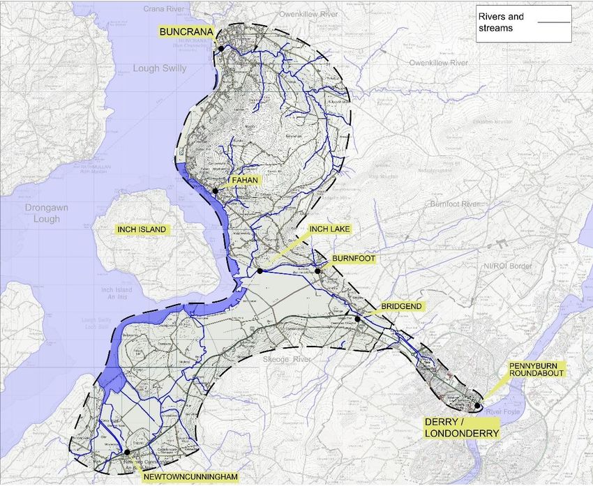
NORTH WEST GREENWAY NETWORK

                     1
Rev 0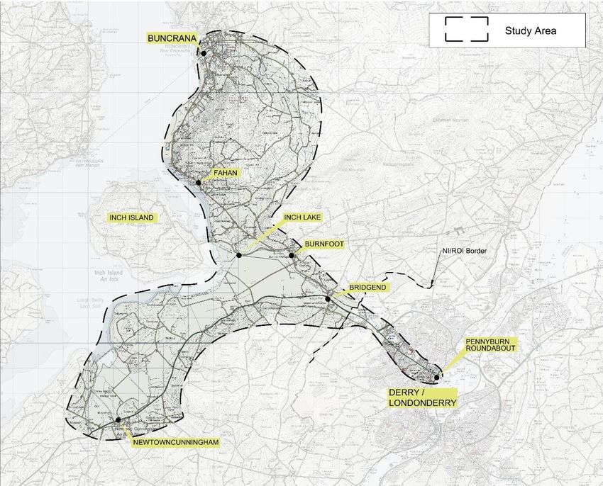
NORTH WEST GREENWAY NETWORK

Quality Control Sheet

   Issue         Date      Prepared    Date         Checked    Date     Approved    Date
   1 (Draft)    25.05.18     RM       May 18         KOS      May 18      RA       May 18
  2 (Draft 2)   12.06.18     RM       June 18        KOS      June 18     SH       June 18
  3 (Draft 3)   14.06.18     RM       June 18        KOS      June 18     SH       June 18
   4 (Rev 0)    21.06.18     RM       June 18        KOS      June 18     SH       June 18

                                                2
Rev 0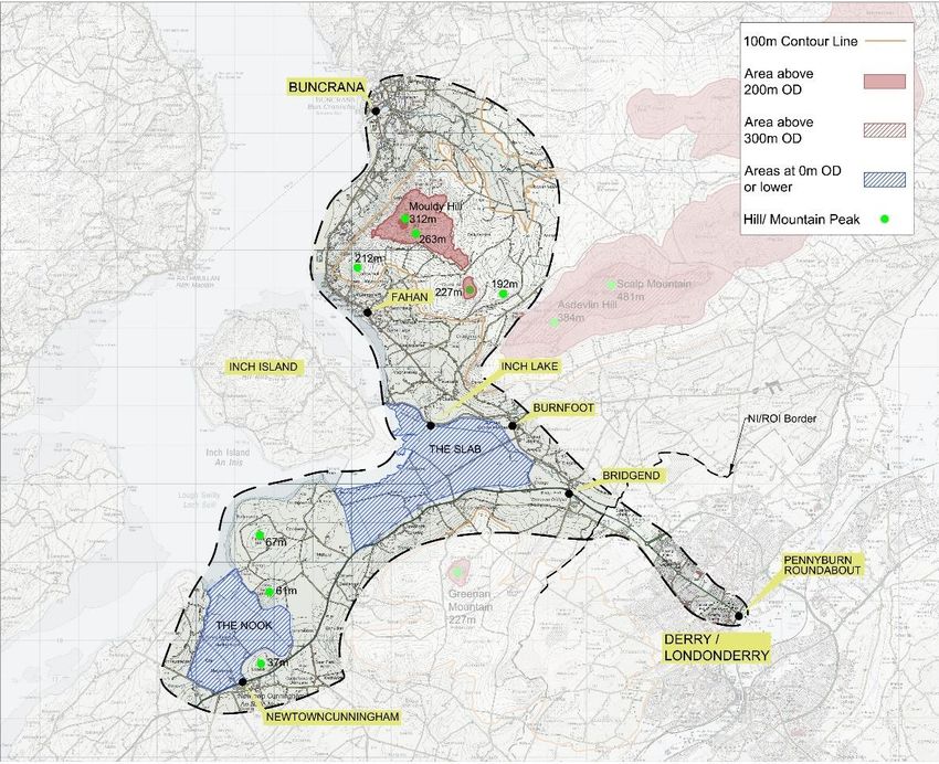
NORTH WEST GREENWAY NETWORK

                     3
Rev 0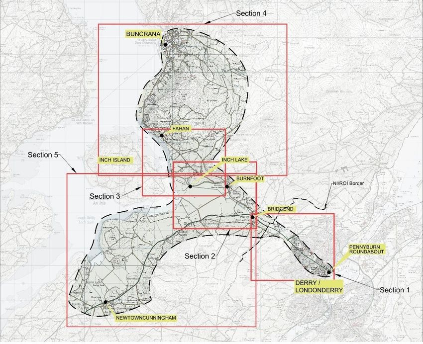
NORTH WEST GREENWAY NETWORK

Contents
0     Executive Summary ....................................................................................................... 7
1     Introduction .................................................................................................................... 8
    1.1     Project Background................................................................................................. 8
2     Policy Documents and guidelines .................................................................................. 9
    2.1     European Policy and Guidelines ............................................................................. 9
    2.2     Northern Ireland Policy and Guidelines ................................................................... 9
      2.2.1        National and Regional Policy Documents ........................................................ 9
      2.2.2        Local Policy Documents: ................................................................................ 11
    2.3     Republic Of Ireland Policy and Guidelines ............................................................ 12
      2.3.1        National and Regional Policy Documents ...................................................... 12
      2.3.2        Local Policy Documents ................................................................................. 15
3     North West Greenway Network Project Description ..................................................... 18
    3.1     Physical Character of a Greenway Facility ............................................................ 18
    3.2     North West Greenway Network – Scheme Overview ............................................ 19
    3.3     Route Specific Aims and Objectives ..................................................................... 20
4     Route Specific Study Area And Potential Route Corridors ........................................... 23
    4.1     Study Area ............................................................................................................ 23
5     Constraints, Opportunities And Areas Of Interest ......................................................... 25
    5.1     Topography........................................................................................................... 25
      5.1.1        Topography - Northern Ireland ....................................................................... 25
      5.1.2        Topography - Republic of Ireland ................................................................... 26
    5.2     Rivers, Streams and Watercourses ....................................................................... 27
      5.2.1        Rivers, Streams and Watercourses - Northern Ireland ................................... 27
      5.2.2        Rivers, Streams and Watercourses - Republic of Ireland ............................... 27
    5.3     Environment and Ecology ..................................................................................... 28
      5.3.1        Designated & Protected Areas – Northern Ireland ......................................... 28
      5.3.2        Designated & Protected Areas – Republic of Ireland...................................... 28
      5.3.3        Ecology, Flora and Fauna – Northern Ireland................................................. 29
      5.3.4        Ecology, Flora and Fauna – Republic of Ireland............................................. 29
    5.4     Existing Land Use and Zoning .............................................................................. 31
      5.4.1        Existing Land Use - Northern Ireland ............................................................. 31

                                                                   4
Rev 0
NORTH WEST GREENWAY NETWORK

      5.4.2       Existing Land Use - Republic of Ireland ......................................................... 31
    5.5     Proposed and Future Developments ..................................................................... 32
      5.5.1       Proposed Developments - Northern Ireland ................................................... 33
      5.5.2       Proposed Developments - Republic of Ireland. .............................................. 33
    5.6     Local Amenities and Attractions ............................................................................ 34
      5.6.1       Local Amenities and Attractions – Section 1 (Pennyburn to Bridgend) ........... 35
      5.6.2       Local Amenities and Attractions – Section 2 (Bridgend to Inch Lake) ............. 37
      5.6.3       Local Amenities and Attractions – Section 3 (Inch Lake to Fahan) ................. 39
      5.6.4       Local Amenities and Attractions – Section 4 (Fahan to Buncrana) ................. 40
      5.6.5  Local Amenities and Attractions – Section 5 (Bridgend / Inch Lake to
      Newtowncunningham).................................................................................................. 42
    5.7     Built Environment and Local Heritage ................................................................... 44
    5.8     Existing Patterns of Travel and Social Interaction ................................................. 46
      5.8.1       Existing Patterns of Travel and Social Interaction .......................................... 46
      5.8.2       Schools and Education Centres ..................................................................... 46
6     Route Corridor options ................................................................................................. 49
    6.1     Section 1 – Derry / Londonderry to Bridgend ........................................................ 49
      6.1.1       Purple Corridor: ............................................................................................. 50
      6.1.2       Blue Corridor:................................................................................................. 50
    6.2     Section 2 - Bridgend to Inch Lake: ........................................................................ 52
      6.2.1       Blue Corridor.................................................................................................. 52
      6.2.2       Red Corridor: ................................................................................................. 53
      6.2.3       Purple Corridor .............................................................................................. 54
    6.3     Section 3 – Inch Lake to Fahan / Buncrana .......................................................... 55
      6.3.1       Blue Corridor.................................................................................................. 56
      6.3.2       Purple Corridor .............................................................................................. 57
      6.3.3       Red Corridor (Tullydish Option) ..................................................................... 57
    6.4     Section 4 – Fahan / Inch Lake to Buncrana .......................................................... 59
      6.4.1       Purple Corridor .............................................................................................. 59
      6.4.2       Blue Corridor - Shoreside Option ................................................................... 60
    6.5     Section 5 – Bridgend / Inch Lake to Newtowncunningham .................................... 62
      6.5.1       Light Blue Corridor ......................................................................................... 62
      6.5.2       Orange Corridor ............................................................................................. 63

                                                                5
Rev 0
NORTH WEST GREENWAY NETWORK

7     Preferred Route Selection Process .............................................................................. 65
    7.1    Public Consultation Process ................................................................................. 65
    7.2    Route Corridor Assessment Criteria ...................................................................... 66
      7.2.1      Modal Shift..................................................................................................... 67
      7.2.2      Connections and Local Access ...................................................................... 67
      7.2.3      Cultural, Heritage and Visual Attractions ........................................................ 67
      7.2.4      Landscape and Visual.................................................................................... 67
      7.2.5      Flora, Fauna and the Environment ................................................................. 67
      7.2.6      Physical Constraints ...................................................................................... 68
      7.2.7      Quality of Service ........................................................................................... 68
      7.2.8      Material Assets and Human Beings ............................................................... 68
      7.2.9      Potential Cost ................................................................................................ 69
      7.2.10     Physical cross-border connectivity ................................................................. 69
      7.2.11     Public Feedback ............................................................................................ 69
    7.3    Sample Preferred Route Selection Matrix ............................................................. 70
APPENDIX A – LIST OF DESIGN GUIDELINES AND STANDARDS ................................. 71
APPENDIX B – DRAWINGS AND FIGURES ...................................................................... 72

                                                               6
Rev 0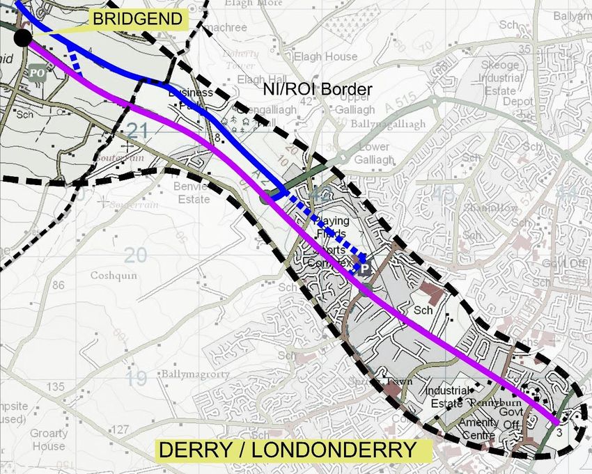
NORTH WEST GREENWAY NETWORK

0   EXECUTIVE SUMMARY

The Constraints Study and Route Options Report describes the Stage 1 of the Route Selection
Process for the proposed Derry / Londonderry to Buncrana Route of North West Greenway
Network (NWGN) Scheme.

It sets out the project background and the European, national and local policy guidelines which
frame the scheme and the development of Greenway Schemes. It also sets out the overall
aims and objectives of the NWGN scheme and route specific aims and objectives of Route 1.

The report identifies a Study Area and describes the Constraints, Opportunities and Areas of
Interest within the Study Area that will inform the selection of a number of “Route Corridor”
Options.

Two Route Corridors from Derry / Londonderry to the border at Bridgend have been identified,
three further Route Corridors from Bridgend to Inch Lake have been identified and a further
three Route Corridors identified from Inch Lake to Buncrana. A separate sub-section contains
two routes to Newtowncunningham, one from Bridgend and one from Inch Lake. Some of
these routes contain sub-options for specific sections of their length. The report describes
these Route Corridors and explains why they were selected.

A number of Assessment Criteria are defined, with an explanation of how each Route Corridor
will be assessed against these criteria.

The Public Consultation Process (of which this report forms a part) that will be undertaken in
advance of the Preferred Route Selection is outlined.

The Preferred Route Selection Process will be undertaken at Stage 2, and this report provides
a sample Assessment Matrix showing how the Preferred Route will be selected.

                                              7
Rev 0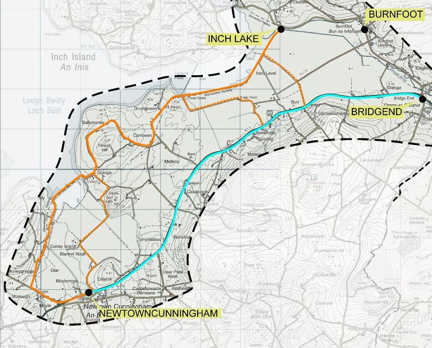
NORTH WEST GREENWAY NETWORK

1     INTRODUCTION

1.1     Project Background
In December 2016 Derry City and Strabane District Council in partnership with Donegal
County Council, the Department for Infrastructure (NI) and Sustrans (the UK-based cycling
and walking charity), secured funding for this project from the EU’s INTERREG VA 2014-2020
programme, monitored by the Special European Union Programmes Body (SEUPB).
McAdam Design has been appointed by Derry City & Strabane District Council to lead the
Integrated Consultant Team (ICT) which will provide co-ordinated NI and ROI Project
Management and Design services to the Project Partners and deliver the North West
Greenway Network (NWGN) Scheme from Preliminary Design, through to Technical Design,
Procurement of the Principal Contractor and managing the delivery of the Construction Stages
to completion of construction.
The core target project outputs of the NWGN project are as follows:
      1. To develop 46.5km of cross-border greenway by December 2021
      2. To achieve a targeted 5.5% rise in cross-border modal shift from the baseline (to be
         established) by December 2022
Core project specific aims are as follows
      1. A reduction in CO2 emissions of 319 metric tons per annum by 2023.
      2. Widespread behavioral and attitudinal change in all targeted beneficiaries through our
         strategic alliance with Sustrans.
      3. Investment in the wider economic and social infrastructure in the Cross Border region.
      4. The project will meet the strategic aims of Derry City and Strabane District Council
         North West Greenways Plan (2015) to develop a comprehensive interconnected
         regional Cross Border Greenway Network.

                                                8
Rev 0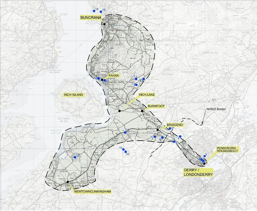
NORTH WEST GREENWAY NETWORK
2 POLICY DOCUMENTS AND GUIDELINES
The following sections describe a non-exhaustive list of European, National (both NI and ROI),
Regional and Local Policy Documents and Guidelines which contain clear policy objectives to
promote and develop sustainable transport and cycling initiatives as well as recreational and
tourism related objectives, which directly support the development of Greenway projects such
as the route covered by this report.
2.1 European Policy and Guidelines
‘Europe 2020 – A Strategy for Smart, Sustainable and Inclusive Growth’ puts forward
three mutually reinforcing priorities for smart, sustainable and inclusive growth. Sustainable
transport strategy is set out under the “sustainable growth” priority, through flagship Initiative:
“Resource efficient Europe”, which supports a shift towards a resource efficient and low carbon
economy.
The TEN-T - Connecting Europe Policy (2014) focuses on connecting Europe through major
infrastructure such as rail and roads. It highlights the potential for long distance walking and
cycling routes.
European Cyclists’ Federation’s EU Cycling Strategy: Recommendations for Delivering
Green Growth and an Effective Mobility in 2030” is the result of a systematic review of all EU
policies related to cycling. The central objectives of the plan are as follows:
Cycling should be an equal partner in the mobility system
Grow cycle use in the EU by 50% at an average in 2019/2020-2030
Cut rates of cyclists killed and seriously injured by half (in km cycled) in 2019/2020-
2030
Raise EU investment in cycling to €3bn in 2021-27; and €6bn from 2028-34.
2.2 Northern Ireland Policy and Guidelines
2.2.1 National and Regional Policy Documents
North West Greenway Plan 2015
The North West Greenways Action Plan (https://www.derrystrabane.com/North-West-
Greenway-Plan) forms the basis of a strategic and co-ordinated plan for the development of a
network of greenways (GW) throughout the North West.
The vision of the Plan is: “To develop a cross border network of Greenways that link people
with places locally, regionally and nationally- bringing social, economic & environmental
wellbeing to all.”
9
Rev 0NORTH WEST GREENWAY NETWORK
Draft Programme for Government Framework 2016-2021
Sustainable travel initiatives support the following draft outcomes:
Outcome 1- We prosper through a strong, competitive, regionally balanced economy
Outcome 2- We live and work sustainably, protecting the environment
Outcome 4- We enjoy long, healthy, active lives.
Outcome 11- We connect people and opportunities through our infrastructure
NI Strategic Plan for Greenways- sets out a high level vision for NI to develop new Greenway
routes and contribute to overall modal shift targets.
A Bicycle Strategy for NI 2014 - The key aims of the Strategy are to provide people the
freedom and confidence to travel by bike and to develop off-road Greenways.
The North West Strategic Partnership- to collaboratively work with central government to,
“Collectively resource the region’s key priorities for growth and development with a
commitment to building a more resilient economy in the North West City Region”
(www.derrystrabane.com)
NI Regional Development Strategy 2035: Building a Better Future 2010- Regional
Guidance Policy 9: “Reduce our carbon footprint and facilitate mitigation and adaptation to
climate change whilst improving air quality- ‘This will include reducing the need to use the car,’
and: Regional Guidance Policy 11 through enhancing the amenity value of natural and cultural
heritage assets by providing linkages to green infrastructure.
DRD Ensuring a Sustainable Transport Future: A New Approach to Regional
Transportation 2012 - The strategy has three overarching aims;
Supporting the growth of the economy
Enhancing the quality of life for all citizens and;
Reducing the environmental impact of transport
Building an Active Travel Future for NI 2012 - aims to increase the overall % of trips taken
by bicycle and the need for a cross-sectoral approach and the development of partnerships in
order to achieve this.
10
Rev 0NORTH WEST GREENWAY NETWORK
2.2.2 Local Policy Documents:
Derry City & Strabane District Council’s Inclusive Strategic Growth Plan 2017-2032 (Our
Community Plan)
Community Planning is a statutory duty placed on Councils as part of local government reform.
Sustainable travel initiatives support the following outcomes of community planning;
Social Wellbeing Outcomes
We enjoy long, healthy, active lives
We give our children and young people the best start in life
We have safer more cohesive communities with access to quality services and facilities
We have improved physical and mental health and emotional wellbeing
We are more physically active
We are supported to age well, live longer and be more independent
Environmental Wellbeing Outcomes
We connect people and opportunities through our infrastructure.
We live and work sustainably, protecting the environment
We benefit from well designed and managed green spaces and public realm
We support environmental stewardship
We value and enhance our environment
Derry Local Development Plan (2030)
Enhancing connectivity in our City & District supports the aims of the emerging Local
Development Plan through provision of sustainable infrastructure which will enhance our
District for future generations.
Derry Area Plan 2011 Section 14.1 in relation to transportation the key aim is to ‘Develop an
efficient, safe, accessible and sustainable transport system which offers better choice and
mobility for all its users.
11
Rev 0NORTH WEST GREENWAY NETWORK
2.3 Republic Of Ireland Policy and Guidelines
2.3.1 National and Regional Policy Documents
Project Ireland 2040 National Planning Framework and National Development Plan
2018-2027
Project Ireland 2040 is the Irish Governments overarching policy initiative for the long term
planning of the State. It is informed by the Programme for a Partnership Government 2016,
which recognises that economic and social progress go hand in hand, and is made up of the
“National Planning Framework to 2040” and the “National Development Plan 2018-2027”.
National Planning Framework to 2040
This is the Government’s high-level strategic plan for shaping the future growth and
development of the country out to the year 2040. It seeks to achieve ten strategic outcomes
including the following which are relevant to the North West Greenway Project:
National Strategic Outcome 3: Strengthened Rural Economies and Communities
including an objective to “Invest in Greenways, blueways and peatways as part of a
nationally coordinated strategy”
National Strategic Outcome 4: Sustainable Mobility including an objective to “Develop
a comprehensive network of safe cycling routes in metropolitan areas to address travel
needs and to provide similar facilities in towns and villages where appropriate.”
National Strategic Outcome 7: Enhanced Amenities and Heritage including an
objective to “Invest in and enable access to recreational facilities, including trails
networks, designed and delivered with a strong emphasis on conservation”
National Strategic Outcome 8: Transition to a Low-Carbon and Climate-Resilient
Society including developing metropolitan cycling and walking networks and
Greenways.
A key policy priority for the Northern and Western Region includes “building on the progress
made in developing an integrated network of Greenways, blueways and peatways that will
support the diversification of rural and regional economies and promote more sustainable
forms of travel and activity based recreation”
The importance of Greenway development to support Rural Job Creation is highlighted noting
that “the development of Greenways, blueways and peatways offer a unique alternative means
for tourists and visitors to access and enjoy rural Ireland. The development of a strategic
national network of these trails is a priority and will support the development of rural
communities and job creation in the rural economy”
National Policy Objective #46 includes the enhancement of “transport connectivity between
Ireland and Northern Ireland, to include cross-border road and rail, cycling and walking routes,
as well as blueways, Greenways and peatways.”
12
Rev 0NORTH WEST GREENWAY NETWORK
National Development Plan 2018 – 2027
The National Development Plan 2018–2027 is the most recent in the series of Government
Capital plans adopted since 1988 and identifies the strategic priorities for public capital
investment for all sectors to meet the strategic outcomes of the National Planning Framework.
It includes as a “Priority Investment Action” the facilitation of Cross Border Sustainable
Transport with the North West Greenway Network listed as a specific action.
Investment in activity based tourism, including Greenways, is identified as be a priority over
the period of the National Development Plan and the publication of a Government Greenways
Strategy is identified as a priority and targeted for Q1/Q2 of 2018.
Investment in sustainable travel measures, including comprehensive Cycling and Walking
Networks for metropolitan areas, and expanded Greenways is also identified as a priority in
delivering a transition to a Low-Carbon society.
Dept. for Transport, Tourism and Sport’s emerging: “Strategy for the Future
Development of Greenways”
Developed following an extensive national consultations process this Strategy outlines the
Irish Government’s objective to assist in the strategic development of Greenways to an
appropriate standard in order to deliver a quality experience for Greenway users. It highlights
the benefits (based on experience to date in the Rep of Ireland) that can arise from the further
development of Greenways as:
a tourism product with significant potential to attract overseas visitors
for local communities in terms of economic benefits
as an amenity for physical activity and a contributor to health and wellbeing.
The Strategy lists a number of National and Regional Greenway projects which are
identified as the initial priorities for development. This list includes the North West
Greenway Network including Route 2 – Derry/Londonderry to Muff.
Smarter Travel - A Sustainable Transport Future
A New Transport Policy for Ireland 2009-2020- The NWGN project supports:
Action 15 of the plan by striving to create a strong cycling culture in the NW;
Action 17 through exploring opportunities to make a former railway line available for
walking and cycling trails.
National Cycle Policy Framework 2009
Ireland’s first National Cycle Policy Framework was launched in April 2009. It outlines 19
specific objectives, and details the 109 individual but integrated actions, aimed at ensuring
that a cycling culture is developed in Ireland to the extent that, by 2020, 10% of all journeys
will be by bike. The NGWN supports the overall aims and objectives of the plan and in
particular (but not limited to):
13
Rev 0NORTH WEST GREENWAY NETWORK
Objective 3: Provide designated rural cycle networks especially for visitors and
recreational cycling.
Regional Planning Guidelines (2010-2022)
The Guidelines acknowledge that current cycling infrastructure in border regions is currently
limited but outlines an aim to encourage greater shift to cycling/ walking by the promotions of
the strategies outlined in the Smarter Travel Policy and the National Cycling Policy Framework
as referenced above.
The NWGN will support specific cycling and walking Policy INFP13 of the Guidelines which
seeks to ‘Promote and support cycling and walking within the Region, particularly within urban
centres.’ while the Guidelines recommend that Local Authorities should also consider the use
of “off road” routes for both walking and cycling such as disused railway lines, canals and
bridle paths to improve access to rural tourist attractions.
People, Place and Policy – Growing Tourism to 2025 (March 2015)
This Government Tourism Policy Statement sets out the Government’s primary objective in
maximising the services export revenue of the sector. The policy highlights the importance of
high quality facilities for activity based tourism in the marketing of Ireland as a holiday
destination. It notes the Government’s support for development and improvement of facilities
for visitor activities including Greenways.
Fáilte Ireland Strategy for Development of Irish Cycle Tourism 2007
Fáilte Ireland (FI) produced its Strategy for the Development of Irish Cycle Tourism in 2007. It
observed that cycle tourism had declined in Ireland since 2000. The FI Strategy also
referenced a research project conducted by the research company MORI in 2005 which found,
among other things, that:
Cycling on Irish roads is not perceived to be safe – cyclists face dangerous bends, fast
cars, intimidating HGVs, more traffic and higher speeds;
There are very few, if any, traffic-free routes to cater for touring cyclists wanting to
leave the cities to discover the countryside or for families who wish to participate in
cycling.
The purpose of the FI strategy was to determine how best to renew the popularity of cycling
in Ireland, how to encourage visitors to come to cycle in Ireland, and how to ensure that cycle
tourism can generate visitor spend in rural areas. It proposed an approximately 3,000km long
cycle network running from Donegal along the West, South and South-east coasts and
continuing along the East coast as far as the Northern Ireland border.
The Strategy identified the following needs for cycle tourists:
Safe places to cycle and consideration from other road users;
Attractive routes with good scenery;
Well-connected and signposted routes and destinations avoiding long detours;
14
Rev 0NORTH WEST GREENWAY NETWORK
Opportunities to visit local attractions and specific places of interest;
Food, accommodation and refreshments available at intervals, which reflect
comfortable distances for stopping off / overnight stops.
Fáilte Ireland Cycling and Activities Research, 2013
In May 2013 Fáilte Ireland commissioned cycling research in order to, among other things,
inform the route selection process of the route. Just over 15,000 people surveyed in Germany,
France, Great Britain and Ireland. Respondents to this market research identified traffic free
cycling and safety of the cycle route as the most important attributes of a tourism cycle route
after a beautiful landscape and scenery.
This research indicates that directness of route is not a critical factor in the provision of a
satisfactory leisure cycle route. On the contrary, picturesque landscapes and traffic free
routes with good connections to towns and villages are rated highly.
Realising our Rural Potential – Action Plan for Rural Development (2017)
A Government Strategy aimed at delivering change for people living and working in Rural
Ireland with key objectives including increasing the number of visitors to rural Ireland by 12%
and supporting the creation of 135,000 new jobs in rural Ireland by 2020.
Specific key objectives and actions of the Strategy supported by the NWGN include:
Develop and promote Activity Tourism in rural areas through the development of
blueways, Greenways and other recreational opportunities.
Develop cross-Border tourism initiatives to support the tourism potential of the Border
region, building on projects such as the Ulster Canal Greenway from Smithboro (Co.
Monaghan) to Middletown (Co. Armagh), the Carlingford Lough Greenway, and
historic literary trails.
2.3.2 Local Policy Documents
(Draft) Donegal County Council Development Plan 2018 – 2024:
Chapter 5 – Infrastructure, Section 5.1, Transportation:
Transportation Policy T-P-11: It is a policy of the Council to facilitate the appropriate
development of affordable, multi-modal transport solutions that offer communities and
future generations real transport choices such as park and ride; pedestrian and cycling;
bus and taxi services; and ancillary infrastructure.
T-P-24: It is a policy of the Council to protect established/historic railway corridors
throughout the County primarily for strategic infrastructure provision (such as rail/road
15
Rev 0NORTH WEST GREENWAY NETWORK
projects) and secondly for recreational development. Along these corridors other uses
shall not be considered. Where these corridors have already been compromised by
development, adjacent lands which could provide opportunities to bypass such an
impediment and reconnect these routes for amenity purposes (walking/cycling) shall
be protected for this purpose. However, in all instances, the over-riding objective shall
be the provision of strategic infrastructure.
T-P-34: It is a policy of the Council to encourage and facilitate joined up long distance
walking and cycling routes for recreation and as alternatives to the car, particularly in
rural areas, between settlements. Adequate car parking facilities shall be provided,
where required, in association with any such developments.
T-P-35: It is a policy of the Council to support and facilitate the maintenance,
enhancement and expansion of the National Cycle Network.
Chapter 9 – Tourism:
Section 9.1 – Other Tourism Products and Attractions (pg 138):
“The Council will ... continue to protect the routes of such potential Greenways through the
policies of this plan and will actively work will all stakeholders to facilitate the development of
Greenways and walking and cycling routes throughout the County.” and “… the Council
recognise that Donegal effectively sits within a wider cross border tourism region and will work
with local authorities and tourism agencies in Northern Ireland to exploit the these natural
cross border synergies in order to unlock the regions full tourism potential.”
It also notes that “Protecting the routes and visual settings of potential Greenways and other
recreational walkways and cycling routes.” is a Key Planning Challenge.
Section 9.1.2, Objectives:
TOU-O-9: To support the development of new, and protect the functionality of existing,
Greenways, walking and cycling routes as keys components of an overall green
tourism infrastructure and as standalone tourism products in their own right.
Action Plan for Jobs: North East/North West 2015 – 2017 notes the following action:
Identify and develop Greenway / blueway networks in the Region (Ref Page 95, Pt
108)
The Donegal Local Economic & Community Plan 2016 – 2022:
Volume 1, identifies ‘To develop Donegal as a Connect Place’ as a priority goal.
Volume 2, sets out the Action Areas of the Plan and notes the following actions:
16
Rev 0NORTH WEST GREENWAY NETWORK
Section 1.9.1: To develop an integrated North West Greenway
Section 1.9.3: To identify a programme of walkways, cycleways and Greenways within
towns and their hinterland, to enhance town centre connectivity, support regeneration
of town centres and improve health and recreation opportunities.
Section 2.4.5: To develop an integrated North West Greenway (Walking, Trails,
Cycling) as a key tourism project on a cross-border basis.
Section 4.4.16: To maximise health and wellbeing outcomes for communities in the
proposed development of the North West Greenway and other initiatives involving
outdoor spaces.
17
Rev 0NORTH WEST GREENWAY NETWORK
3 NORTH WEST GREENWAY NETWORK PROJECT DESCRIPTION
3.1 Physical Character of a Greenway Facility
A Greenway is a traffic-free route designed exclusively for the use of pedestrians and cyclists.
The character of the route is generally low-key in terms of its impact on the overall landscape
of an area and its environmental effects. The route may be “online” within an existing road
corridor located within the verge or footway, or “offline” located entirely off road and traffic free.
The North West Greenway will generally be constructed as a 3m wide shared use path, with
a bituminous surface to provide a high quality finish for cyclists.
In urban areas the Greenway will generally be online with a 1m buffer strip provided where
lands are available, giving a desirable Greenway ‘corridor’ of 4m, while options for offline / fully
segregated sections will be explored where possible. The path width, or the buffer strip, or
both, may be reduced through sections where constraints such as buildings, boundaries and
carriageway kerblines cannot reasonably be adjusted. Where possible, appropriate screening
in the form of shrubs, plants and/or trees will be planted as part of the Greenway corridor to
create wildlife habitats and to improve the visual quality of the infrastructure.
In rural sections the Greenway route may be either online or offline, or a combination of both.
Where proposed offline routes are being identified the planning of the route will seek to follow,
in so far as possible, field boundaries and land-holding boundaries, or existing laneways, rivers
or other corridors to avoid disturbance to farming activity. The geometry of the facility is flexible
and the route will be designed to minimise farm severance or agricultural impacts, apart from
the loss of the small area of land forming the scheme footprint.
Figure 1 in Appendix B, shows the typical cross sections proposed for urban and rural sections
of the Greenway.
Depending on the nature and alignment of the route, the Greenway may or may not be fenced
along each side. If required, a consistent standard of fencing will be agreed with adjacent or
affected landowners dependent on the location or adjacent land uses. Greenway lighting will
be provided in urban areas, and will be considered if necessary across rural sections subject
to environmental and other restrictions, with any proposed specification being cognisant of,
and sympathetic to, the rural landscape setting.
Gradients along the Greenway will preferably not exceed 3%, but may be relaxed to 5% if the
topography requires. Short sections of 10% gradients may be considered in exceptional
circumstances. Similarly, the horizontal alignment will be designed for gentle radii and gradual
changes in direction, with a minimum radius of 4m.
18
Rev 0NORTH WEST GREENWAY NETWORK
3.2 North West Greenway Network – Scheme Overview
The proposed North West Greenway Network Scheme consists of three distinct Greenway
Routes, totalling 46.5km shared pedestrian / cycle paths, with each route crossing the
Northern Ireland (NI) / Republic of Ireland (ROI) border. The Routes are summarised as
follows:
Route 1 – Derry to Buncrana – approx. 32.5km
Route 2 – Derry to Muff – approx. 10.5km
Route 3 – Strabane to Lifford – approx. 3.5km
Each route will be designed in accordance with relevant design standards, including (but not
limited to) the National Cycle Manual, Handbook for Cycle-Friendly Design, Design Manual
for Roads and Bridges (DMRB), Cycle Traffic and the Strategic Road Network (IAN 195/16)
and Rural Cycleway Design (DN-GEO-03047) and will include associated feature lighting,
hard and soft landscaping, furnishings, accommodation works and appropriate safety
features.
A (non-exhaustive) list of design guidelines and cycling standards that will inform the
Greenway Design are included in Appendix A of this report.
This report focuses on Route 1 – Derry / Londonderry to Buncrana, and describes the Study
Area, Constraints, Opportunities and Areas of Interest and Route Corridor Options for that
Route only. Route 1 forms part of a wider Inis Eoghain Greenway route identified in the North
West Greenways Action Plan which is envisaged to eventually extend beyond Buncrana to
the north via Carndonagh and will also have links to the proposed cycle corridor to
Letterkenny. The development of this Route should facilitate connection to these future
provisions.
19
Rev 0NORTH WEST GREENWAY NETWORK
Figure 3.2 – North West Greenway Network – Route Overview
3.3 Route Specific Aims and Objectives
The Project Partners have identified the following strategic Aims aligned to European, National
and Local Policies (as outlined in Section 2.0), which set out the Core benefits which the
development of the Greenway Route seeks to achieve.
SMART objectives have been developed to ensure overarching Project Aims are achieved.
All Aims and Objectives are targeted for substantial delivery by December 2021 based on
current project programme.
Route 1 Derry / Londonderry To Buncrana Scheme - Aims
Social:
Physically connecting People and Places within the region to link and enhance the
social fabric of the communities.
Achieve an increase in Modal Shift to more sustainable methods of travel (on foot or
by bike) between the communities and destinations linked by the project.
Promote health and wellbeing in the communities connected by the project.
20
Rev 0NORTH WEST GREENWAY NETWORK
Enhance road safety for existing vulnerable and non-motorised road users.
Economic:
Increase Modal Shift to more cost effective and sustainable forms of transport.
Improve and enhance the Tourism Offering of the North West Region, attracting
increased numbers of visitors.
Increase the economic contribution of tourism to the Local Economy and provide a
catalyst and opportunities for economic growth.
Enhance the cycling tourism offering within the region.
Environmental:
Contribute to reducing carbon emissions in the area through achieving a rise in modal
shift.
Value and enhance the natural environment by creating a ‘green’ linear corridor to the
benefit of wildlife through sensitive landscaping.
Route 1 Derry / Londonderry To Buncrana Scheme - Objectives
Connect the town of Buncrana (Co. Donegal) and the commuter villages of Fahan (Co.
Donegal), Burnfoot (Co. Donegal) and Bridgend (Co. Donegal) with the city of Derry /
Londonderry.
Connect the town of Buncrana (Co. Donegal), the city of Derry / Londonderry (NI) with
the town of Newtowncunningham (Co. Donegal).
Create a safe and pleasant amenity along which the local population can commute,
socialise, and use as a recreational and leisure facility, and which promotes active
lifestyles, physical exercise and participation in outdoor activities.
Provide connection to existing and planned educational, recreational and leisure
facilities such as schools, parks and open spaces, playgrounds, walks and trails,
cycling routes, sports clubs and facilities.
Provide a shared use Greenway route that is safe, comfortable and attractive to all
user groups (both cycling and walking) and provides a reliable and safe level of service.
Provide a route that can facilitate comfortable combined use by cyclists and
pedestrians in an environment that feels safe to both user groups, particularly in areas
with high levels of mixed activity.
Provide connection to existing and planned tourism initiatives and infrastructure such
as the Cityside Greenway network and the National Cycle Network, as well as the
Causeway Coastal Route (which transits through Derry / Londonderry) and Wild
Atlantic Way (which passes through Bridgend).
Provide high quality infrastructure which will attract increased visitors to the area and
drive the demand for associated cycling/walking related facilities e.g. cafes, bike hire
etc.
Offer an attractive and cost effective sustainable alternative to private motor vehicle
transport by providing connections between residential areas and areas of
employment, commercial centres and recreational facilities.
21
Rev 0NORTH WEST GREENWAY NETWORK
Facilitate Cycle Tourism by providing direct physical connections between larger
settlements which provide services for visitors to the region - such as overnight
accommodation, retail outlets, entertainment and other attractions, bicycle repair, and
public transport connections.
Provide linkages to smaller settlements which provide basic facilities such as food,
toilets and convenience shops.
Facilitate access to existing visitor attractions and activities along the route either
directly adjacent or accessible via a lateral link or otherwise which is suitable for
walking/cycling.
Develop the most cost effective route that, where possible, mitigates the impact on
private lands and maximises use of available public lands, provided always that the
route meets the needs of all user groups and meets the Route aims and objectives
outlined above.
22
Rev 0NORTH WEST GREENWAY NETWORK
4 ROUTE SPECIFIC STUDY AREA AND POTENTIAL ROUTE CORRIDORS
4.1 Study Area
In defining the Study Area, the Project Team considered the costal nature of the route to
Buncrana, to Newtowncunningham and the border location of Bridgend relative to Derry /
Londonderry, the connecting road networks and physical boundaries.
The southern extent of the Study was defined as Derry / Londonderry, at Pennyburn
Roundabout and the end of cityside Greenway network along the River Foyle. This is also the
interface with Route 2 of the proposed North West Greenway Network.
Between the Pennyburn Roundabout and Bridgend, the northern and southern boundaries
were defined by the residential areas and rising topography of Pennyburn, Shantallow and
Galliagh in urban areas and the rising topography towards Elagh More and Coshquin
respectively in rural areas.
Between Bridgend and Inch Lake, the northern boundary was defined by the rising topography
of Trooperstown and Cashel Hill. The southern boundary was defined by the rising topography
of Greenan Mountain and the agricultural lands of the Inch Levels. The Western boundary was
defined by the waters of the Inch Wildfowl reserve.
Between Inch Lake and Buncrana, the eastern boundary was defined by the rising topography
of the sequence of Carrick Hill, Gollan Hill, Mouldy Hill and the Gransha area. The western
boundary was defined by the shore of Lough Swilly.
Between Inch Lake and Buncrana, given the limited width potential corridor in area of
Lisfannon and Figary (from the shores of Lough Swilly to the steeply rising topography of
Gollan Hill and Mouldy Hill) the study area has been extended to include the higher ground to
the east, in the interests of a full and wide ranging assessment of all possible options.
Between both Bridgend / Inch Lake and Newtowncunningham, the south-eastern and eastern
boundaries were defined by the rising topography of the sequence of Greenan Mountain and
Bogay Hill. The south-western and western boundaries were defined by the coastline of the
Inch levels, Blanket Nook and Lough Swilly.
There are two main roads within the Northern Ireland section of the Study Area; A2 Derry to
Bridgend, and A515 Ferndale Rd Road. The A2 connects Derry / Londonderry with the border
at Bridgend, while the A515 intersects the A2 at the Skeoge roundabout and links to the
residential areas of Shantallow, Lenamore and Steelstown.
The Study Area within Northern Ireland is a mix of residential settlements, light industrial
development and limited areas of greenfield / agricultural lands.
There are two main roads within the Republic of Ireland section of the Study area; N13 national
primary route and R238 Buncrana Road; The N13 links the border at Bridgend (i.e. the end of
the A2) to Bridgend village and onwards through Newtowncunningham. The R238 links
Bridgend village with the town of Buncrana, via the villages and townlands of Burnfoot,
Tooban, Fahan and Lisfannon. There are a number of quiet local roads and tracks located in
or around the N13 and R238, as well as both agricultural and undeveloped back lands, and
the Study area also includes these.
23
Rev 0NORTH WEST GREENWAY NETWORK
The Study Area within the Republic of Ireland includes portions of the Inch Wildfowl Reserve,
Lough Swilly Special Protection Area (SPA), Lough Swilly Special Area of Conservation
(SAC), Inch Wildfowl Reserve, Lough Swilly Marina, North West Golf Club and Buncrana Golf
Club in the west and north and the Grainan of Ailigh in the south east. The area is a mix of
residential settlements, some isolated light industrial development and greenfield / agricultural
lands.
Within Sections 5 & 6 of this report, route corridors are considered under 5 individual sub-
areas or sections. These are:
Section 1: Routes from Derry / Londonderry to Bridgend
Section 2: Routes from Bridgend to Inch Lake.
Section 3: Routes from Inch Lake to Fahan / Buncrana
Section 4: Routes from Fahan / Inch Lake to Buncrana
Section 5: Routes from Bridgend / Inch Lake to Newtowncunningham
Figure 4.1 below describes the Proposed Study Area.
Note – All figures included in this report are included in Appendix B.
Figure 4.1 - Proposed Study Area
24
Rev 0NORTH WEST GREENWAY NETWORK
5 CONSTRAINTS, OPPORTUNITIES AND AREAS OF INTEREST
The preferred route of the completed Greenway will be influenced by:
physical and environmental constraints within the Study Area including impact on
human beings and existing land use
location of trip generators which offer significant potential to ensure significant usage
and increase modal shift
features within the Study Area that will offer opportunities to connect settlements and
communities to each other, and to desired destinations (e.g. amenities, commercial or
employment areas) via the proposed Greenway; and will provide greatest opportunity
for active travel and modal shift;
Areas of interest, attractions, scenery and amenities within the Study Area that may
attract tourists and visitors to the Greenway and the wider region, and/or service the
needs of users of the Greenway (e.g. cafes, toilet facilities)
Geometric design standards
Comparative Cost
This section describes the Study Area in terms of a range of headings which will help inform
the design of the proposed Greenway.
Note - Description of each heading (where appropriate) is split between Northern
Ireland and Republic of Ireland to facilitate subsequent reporting required in each
jurisdiction.
5.1 Topography
5.1.1 Topography - Northern Ireland
The topography across the Study Area is relatively flat, with no significant hills or mountains.
Levels rise from sea level at the Foyle Estuary, to levels varying between 5m OD (eastern
end) and 10m (at the Bridgend Border) along the A2. The highest point within the Study Area
is approximately 30m OD in the area of the intersection of the B507 Northland road and the
Springtown road.
The section of the A515 between Buncrana Road and Racecourse Road has a steep gradient
which is not desirable and may deter some leisure cyclists.
This flat topography should lend itself well to the proposed Greenway, it will minimise any
requirement for significant earthworks and any inclines will be of a gradual gradient which will
attract commuting and leisure cyclists.
25
Rev 0NORTH WEST GREENWAY NETWORK
5.1.2 Topography - Republic of Ireland
The topography across the Study Area shows some elevational change, some of which are
more pronounced in the eastern extent of the study area between Tooban and Buncrana.
On the Swilly side corridors, levels rise from sea level at Lough Swilly, to levels varying
between 5m OD (Buncrana) along the R238, 20m (at Figary) along the R238 and 10m (at
Bridgend) along the N13.
On the Tullydish corridor, levels rise from 15m OD (Halfway House) along the R238 to levels
varying between 140m OD (Monreagh), 80m OD at (Tullydish bridge) and 5m OD (Buncrana).
On the Newtowncunningham corridors, levels rise from 10m OD (at Bridgend) and 5m OD
(Inch Lake) to levels varying between 30m OD (Burt) along the N13, 30m OD (Hill Head) and
10m OD (Newtowncunningham).
The highest point within the Study Area is approximately 150m OD on the perimeter of Carrick
Hill.
Figure 5.1 – Topography
26
Rev 0NORTH WEST GREENWAY NETWORK
5.2 Rivers, Streams and Watercourses
Rivers and streams offer significant features across certain parts of the Study Area and
providing views or connections with such water features will be considered as part of the route
selection process.
5.2.1 Rivers, Streams and Watercourses - Northern Ireland
The Skeoge River runs roughly parallel to, but is separated from, the alignment of the A2
between the Skeoge Roundabout to the Border within the study area and consideration will
be given to reflecting this alignment in Greenway corridors in this area.
The study area is bounded on the east by the shore of the Foyle Estuary, which is part of the
Lough Foyle Special Protection Area. This is discussed further in Section 5.3
5.2.2 Rivers, Streams and Watercourses - Republic of Ireland
The Skeoge River runs roughly parallel to, but is separated from, the alignment of the N13
between the Border and Bridgend. This river continues roughly parallel with the R238 until
before Burnfoot, where the river enters a system of man-made water management canals to
Inch Lake.
The Burnfoot River runs roughly parallel with the R238 from Burnfoot to its intersection with
the Skeoge river management channel at Inch Lake.
The Crana River runs perpendicular to the R238 at the outskirts of the town of Buncrana,
where it enters Lough Swilly.
There are a number of water management channels and minor tributaries within the Inch
Levels and the Blanket Nook area.
The Tullydish River crosses the study area in the transit between Bawnloge and Tullydish
Upper.
A number of river embankments and water channels within the study area in the areas of the
Skeoge River, Burnfoot River and the Blanket Nook are maintained by the Office of Public
Works (OPW) and will have requirements in terms of access and maintenance.
A number of smaller rivers and streams run through the Study Area, but these are not seen
as significant points of interaction due to their size or environs.
The Lough Swilly, and its associated wetlands form the western and south western boundary
of the study area and provide a number of points of scenic interest and engagement such as
a marina at Fahan and popular beaches at Lisfannen and Tra Ban. Lough Swilly adjacent to
the Study area is part of the Lough Swilly Special Protection area and the Lough Swilly Special
area of Conservation. This is discussed further in Section 5.3.
Within the study area, consideration will be given to reflecting or engaging with these
watercourses and with Lough Swilly in the alignment in Greenway corridors.
27
Rev 0NORTH WEST GREENWAY NETWORK
Figure 5.2 – Rivers, Stream and Watercourses
5.3 Environment and Ecology
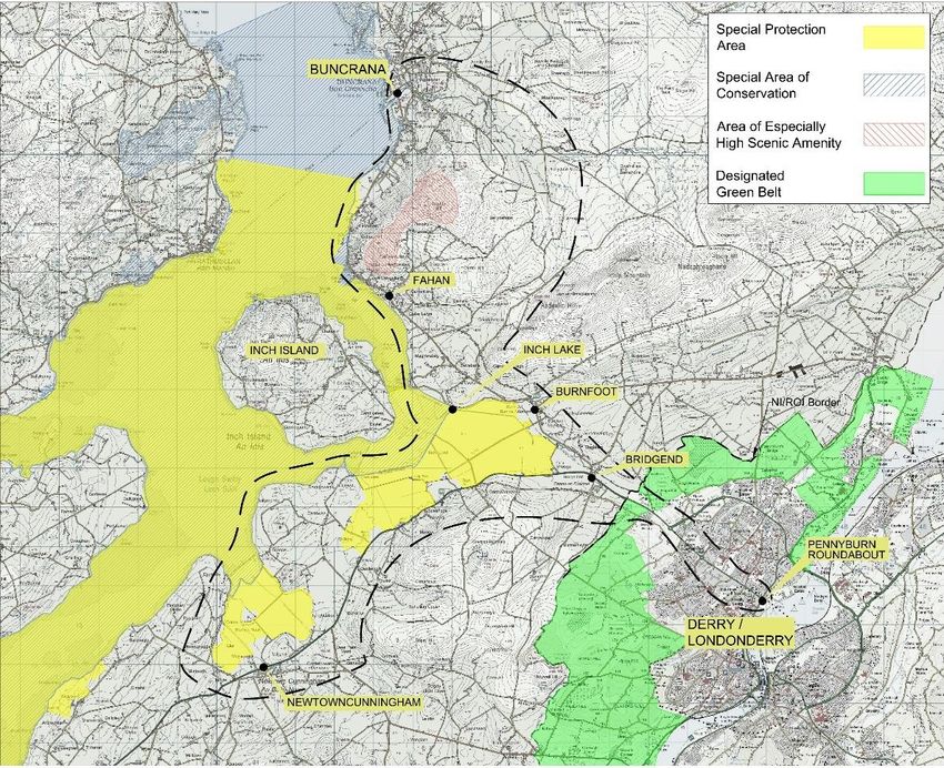
5.3.1 Designated & Protected Areas – Northern Ireland
The Study Area is bounded on the east by the shores of Lough Foyle. The Lough Foyle
Special Protection Area (SPA) was designated in 1999 and qualifies for its designation under
Article 4.1 of EC Directive 79/409 for its numbers of wintering birds, i.e. Whooper Swan, Brent
Goose and Bar-tailed Godwit. It also qualifies under Article 4.2 for its numbers of a wide range
of waterfowl. While the SPA area is bounded by the shoreline, any development which has
potential to impact on the species for which the SPA is designated area may need to be
assessed in accordance with the Habitats Directive.
5.3.2 Designated & Protected Areas – Republic of Ireland
The Lough Swilly SPA bounds the Study Area along the Inch levels and along the western
costal boundary northwards to the upper extent of the SPA at Lisfannan beach. The Lough
Swilly SPA was enacted by S.I. no. 592 of 2012 under the European Communities
(Conservation of Wild Birds (Lough Swilly Special Protection Area 004075)) Regulations 2012.
While the SPA is bounded by the shoreline or designated portions of low lands or wetlands,
28
Rev 0NORTH WEST GREENWAY NETWORK
any site-specific operations or activities as outlined in the order within a set distance of the
boundary of the SPA require the consent of the Minister of the day.
The Lough Swilly SAC bounds the Study area along the Inch levels and along the western
costal boundary northwards to Buncrana. The Lough Swilly SAC, site code 002287 was
selected as a SAC for the following habitats and/or species listed on Annex I/II of the E.U.
Habitats Directive: Estuaries, Costal Lagoons (priority), Atlantic Salt Meadows, Molinia
Meadows, Old Oak Woodlands, Otter (Lutra lutra). While the SAC is bounded by the shoreline
or designated portions of low lands or wetlands, certain activities require prior notification to
the Minister of the day.
Portions of route corridors between Burnfoot to Buncrana have the potential to run close to,
or through, portions of both of these areas.
An area of the hill lands at Fahan / Lisfannon are designated Areas of Especially High Scenic
Amenity under the County Donegal Development Plan 2012-2018.
5.3.3 Ecology, Flora and Fauna – Northern Ireland
Aside from the Lough Foyle SPA, there are few notable areas of ecological interest within the
Study Area, with carriageways generally free from trees and foliage beyond grasses and light
brush. The potential exists for the presence of invasive species, e.g. Japanese Knotweed and
Salmonberry. Detailed surveys to establish the extent of invasive species will be progressed
as the preferred route corridor emerges.
Carriageways and roads are bounded by hedgerows consisting of native species such as
hawthorn, ash, sycamore and beech.
5.3.4 Ecology, Flora and Fauna – Republic of Ireland
Aside from the Lough Swilly SPA and SAC, there are few notable areas of ecological interest
within the Study Area, with carriageways and pathways generally bounded by hedgerows or
light woodlands consisting of native species such as hawthorn, ash, sycamore and beech.
The potential exists for the presence of invasive species, e.g. Japanese Knotweed and
Salmonberry. Detailed surveys to establish the extent of invasive species will be progressed
as the preferred route corridor emerges. Donegal County Council are currently undertaking
an eradication project on such species along public carriageways.
29
Rev 0NORTH WEST GREENWAY NETWORK
Figure 5.3 – Environmental Designations
Note - Preliminary surveys and assessments of ecology, birds and mammals are
currently being progressed across the Study Area. Detailed surveys will be
progressed as required and in accordance with Environmental legislation and
regulations. Where impact on habitats and species is unavoidable appropriate
mitigation procedures will be explored and implemented to ensure minimal
disturbance.
30
Rev 0NORTH WEST GREENWAY NETWORK
5.4 Existing Land Use and Zoning
5.4.1 Existing Land Use - Northern Ireland
Outside of the urban areas, lands across the Northern Ireland section of Study Area are
predominantly agricultural / greenfield or light industrial. Farming and agricultural practices
are mostly tillage and crops with some grazing of livestock also evident.
The A2 has a number of industrial estates along its length, both within the urban area
(Pennyburn, Springtown) and in the mainly rural areas (Elagh). Retail parks with are located
at both the Pennyburn roundabout and Branch roundabout
Figure 5.4.1 – Existing Land Use - Northern Ireland
5.4.2 Existing Land Use - Republic of Ireland
Outside of the urban area of Buncrana and the smaller communities of Bridgend, Burnfoot,
Tooban, Fahan, Burt and Newtowncunningham land use is mainly agricultural, with only
limited retail or industrial properties along the route corridors. The exception to this is the
industrial estate at Lisfannon.
31
Rev 0You can also read