Sedimentary Facies Analysis, Reservoir Characteristics and Paleogeography Significance of the Early Jurassic to Eocene Carbonates in Epirus Ionian ...
←
→
Page content transcription
If your browser does not render page correctly, please read the page content below
Journal of
           Marine Science
           and Engineering

Article
Sedimentary Facies Analysis, Reservoir
Characteristics and Paleogeography Significance of
the Early Jurassic to Eocene Carbonates in Epirus
(Ionian Zone, Western Greece)
George Kontakiotis * , Leonidas Moforis *, Vasileios Karakitsios and Assimina Antonarakou
 Department of Historical Geology and Paleontology, Faculty of Geology and Geoenvironment,
 National and Kapodistrian University of Athens, Panepistimiopolis, 15784 Athens, Greece;
 vkarak@geol.uoa.gr (V.K.); aantonar@geol.uoa.gr (A.A.)
 * Correspondence: gkontak@geol.uoa.gr (G.K.); leomof@geol.uoa.gr (L.M.); Tel.: +30-2107274804 (G.K.)

 Received: 27 August 2020; Accepted: 10 September 2020; Published: 11 September 2020

 Abstract: Sedimentological, micropalaeontological, and marine geological results from the Early
 Jurassic to Eocene carbonate formations of the Ionian zone, from six localities of Epirus, provide new
 insights into the basin palaeogeographic evolution and better correlation with coeval analogous
 tectono-stratigraphic successions along the southern margin of the Neo-Tethys Ocean. Facies analysis
 allowed the recognition of several microfacies types and their depositional characteristics. During the
 Early Jurassic, autochthonous carbonates (Pantokrator Limestones) were deposited in shallow-water
 environment. The overlying (hemi)pelagic Siniais or their lateral equivalent Louros Limestones
 were deposited to the basin borders and mark the general deepening of the Ionian domain.
 During Toarcian to Tithonian, the Ionian Basin was characterized by an internal differentiation
 in small sub-basins with half-graben geometry presenting abrupt thickness and facies changes.
 The deeper parts were characterized by continuous sedimentation, while the elevated parts were
 marked by unconformities. The Early Cretaceous marks the homogenization of sedimentation by
 the deposition of the pelagic Vigla Limestones all over the Ionian zone. The transition from the Early
 to Late Cretaceous records a significant carbonate diversification in terms of biota assemblages,
 and related mineralogy due to intense tectonic activity in the region. From Late Cretaceous to
 Paleogene, allochthonous carbonates were transported to the outer shelf by turbidity currents
 (calciturbidites) and/or debris flows (limestones with breccia) formed by the gravitational collapse of
 the platform margin. Additional porosity and bulk density measurements showed that petrophysical
 behavior of these carbonates are controlled by the depositional environment and further influenced
 by diagenetic processes. The partly dolomitized neritic Jurassic carbonates, but mainly the Senonian
 calciturbidites and the microbrecciated Paleocene/Eocene limestones display the higher average
 porosity values, and therefore present enhanced carbonate reservoir quality.

 Keywords: microfacies types; Pantokrator Limestones; Vigla Formation; Senonian calciturbidites;
 Eocene brecciated limestones; carbonate porosity; petroleum prospectivity; stratigraphic correlations;
 marine biogenic carbonates; depositional environment

1. Introduction
     Marine biogenic carbonates are among the most important archives of Earth’s history reflecting past
changes in ocean chemistry, water mass circulation and the evolution of life [1–10]. Particularly during
the Cretaceous, changes in climate, oceanographic circulation, sea level, tectonic and volcanic
activity contributed to triggering widespread crisis events, which resulted in world-wide anoxic

J. Mar. Sci. Eng. 2020, 8, 706; doi:10.3390/jmse8090706                           www.mdpi.com/journal/jmse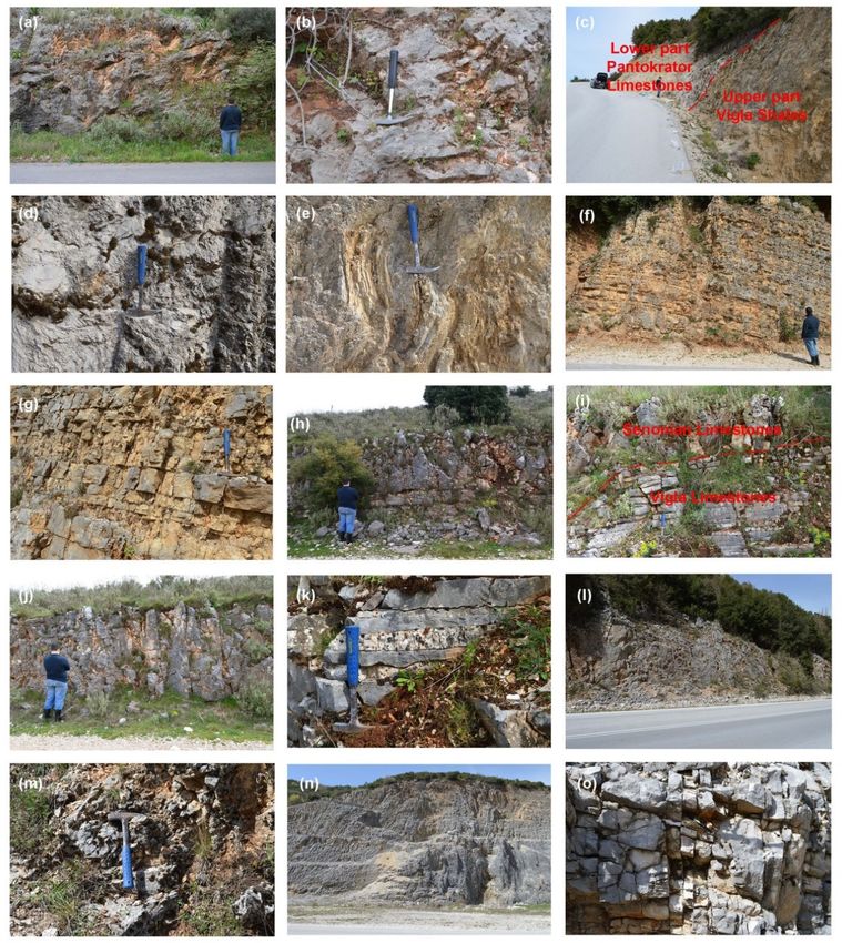
J. Mar. Sci. Eng. 2020, 8, 706                                                                       2 of 25

episodes [11–17], drastic facies variations and biotic changes [18–23], and diffusion of bauxite
deposits [24,25], among others. Such complex events were reflected on biotic and non-biotic constituents
of the carbonate platforms and on the architecture of their depositional systems.
     Within the Mediterranean Tethys (Neo-Tethys) Ocean, the Mesozoic-Paleogene Eras witnessed
the development of vast carbonate platform belts that fringed its margins and passed into deep
marine equivalents, completing thus the marginal succession in the deeper parts of the basin [26–29].
These successions, including the slope deposits in the platform margins, provide an excellent example
of the evolution of depositional sequences ranging from the platform through rimmed carbonate-shelf
to pelagic depositional settings, and further characterize long intervals in the rifting and subsidence
history of past peri-Tethyan continents. Among them, the carbonate platform to basin transition can
give rise to fragmentary distribution of marginal slope successions as fault-bounded units [30–32].
Such confined carbonate units are also considered to be aquifer systems, hydraulically independent of
their siliciclastic cover, and therefore, can build prolific reservoirs and become potential exploration
targets for oil and gas throughout the entire Mediterranean basin.
     Within the Ionian Zone, both the Early Jurassic neritic limestones and dolomites, and the
Late Cretaceous to Eocene re-sedimented carbonates (calcareous turbidites and coarser breccia)
are considered the main reservoir successions and exploration targets for oil and gas in western
Greece [33–35], central and southern Adriatic offshore Italy [36,37], and onshore Albania [35,38–40].
The Jurassic karstified platform carbonate facies represent an excellent analogue for the carbonate
reservoirs, where the sea-level drawdown and subaerial exposure of the carbonate reef enhanced the
facies reservoir quality. Moreover, the calciturbidites can be of great economic importance and they can
serve as reservoir rocks [39,41,42], due to their high porosity and bulk density values, which can be
additionally enhanced by the development of chert nodules [43]. However, the nature and distribution
of these deposits along with their depositional mechanism processes and environmental conditions,
especially in western Greece, are still poorly constrained. The high heterogeneity related to fabric,
texture, fractures that usually characterize such kind of reservoirs has been highlighted by several
authors [42,44–51]. Understanding heterogeneity of carbonate reservoir helps predicting reservoir
petrophysical and geomechanical behaviors [52–54], which in turn play a crucial role in their exploration,
production, and development [55–57]. In this regard, high-resolution sedimentological outcrop data
are essential, because they help to fill the gap with respect to subsurface data, which assists in refining
reservoir models. Petrographic constraints based on facies analysis provide sedimentological features
and micro-textural characteristics, which are the key-link between the rock depositional/diagenetic
history and its physical properties.
     In the present study, we introduce a complete record of the marginal successions in the western
(Ionian basin) segment of the southern Tethys, which consists of the Early Jurassic to Eocene carbonate
platform and slope to basin successions from the Epirus region (Figure 1). This integrated study aims
to define the Mesozoic-Paleogene depositional history, based on lithostratigraphic characteristics and
reservoir petrophysical behaviors in the central Ionian domain, a major hydrocarbon prolific basin in
western Greece. This was accomplished by detailed sedimentological and geomechanical/petrophysical
analyses of the carbonate succession, in conjunction with a synthetic paleogeographic reconstruction.
Beyond the hydrocarbon prospectivity, this work has further implications for regional geology, since it
contributes to describing the evolution of these carbonates, and to a better understanding of the Ionian
zone (pre-, syn- and post-rift stages; [34,58]) in western Greece, a region with crucial economic and
strategic importance.
J. Mar. Sci. Eng. 2020, 8, 706 3 of 25
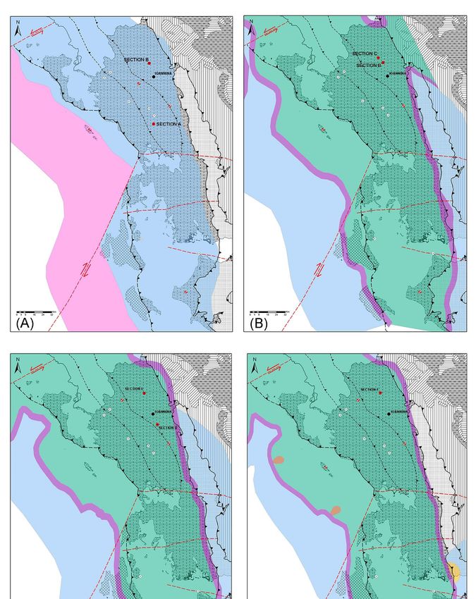
J. Mar. Sci. Eng. 2020, 8, x FOR PEER REVIEW 3 of 26
Figure 1.
Figure 1. Geological
Geological map
map ofof the
the external
external Hellenides
Hellenides in
in NW
NW Greece
Greece (modified
(modified from
from [34,35])
[34,35]) illustrating
illustrating
the principal
the principal tectonostratigraphic
tectonostratigraphic zones:
zones: Pre-Apulian,
Pre-Apulian, Ionian,
Ionian, Gavrovo,
Gavrovo, Pindos.
Pindos. The
The red
red box
box shows
shows
the study area, the northwestern part of the Epirus region, where the separation of Ionian
the study area, the northwestern part of the Epirus region, where the separation of Ionian zone to zone to
external, middle, and internal sub-basins along with the regional locations of the study sections
external, middle, and internal sub-basins along with the regional locations of the study sections to be to be
also indicated.
also indicated. Legend
Legend interpretations
interpretations are
are presented
presented in
in the
theinset.
inset.
J. Mar. Sci. Eng. 2020, 8, 706                                                                       4 of 25

2. Geological Setting

2.1. Tectonostratigraphic Evolution of Ionian Basin
     Western Greece is dominated by the external zones of the Hellenides fold-and-thrust belt,
namely the pre-Apulian, Ionian and Gavrovo-Tripolis zones. At a regional scale (hundreds of kilometers),
this Alpine belt records the initiation, development and final destruction of the southeastern margin of
the Tethys Ocean and the consequent continent-continent collision between the Apulian and Pelagonia
micro-continents to the east [34,58–63]. On a smaller scale (tens of kilometers), the various sub-basins
of the Hellenic Tethyan margin have been inverted to produce the main Hellenic thrust sheets or
folded zones [58,59,64]. The Ionian zone, which is bounded westwards by the Ionian thrust and
eastwards by the Gavrovo thrust, extends from Albania to the north, forms most of the Epirus region
and parts of the Ionian islands and continues southwards to central Greece, Crete and the Dodecanese.
According to [65,66], the Ionian basin was subdivided into the internal, central and external Ionian
sub-basins (Figure 1).
     The tectonostratigraphic evolution of the Ionian zone is reflected on the deposition of three distinct
sequences indicative of different tectonic regimes [34,58]: (1) a pre-rift sequence is represented by the
Early Jurassic platform Pantokrator Limestones, which overly Early to Mid-Triassic evaporites through
Foustapidima Limestones of Ladinian-Rhetian age, (2) a syn-rift sequence (Pliensbachian-Tithonian)
deposited during extensional faulting and halokinesis of the Triassic evaporites, which caused
the formation of the Ionian basin and its internal synrift differentiation into smaller sub-basins
characterized by asymetric half-graben geometry and different carbonate thickness accumulation [42,58].
Complete Toarcian-Tithonian syn-rift pelagic sequences (Siniais and lateral equivalent Louros
Limestones, Ammonitico Rosso or lower Posidonia beds, Limestone with filaments, Upper Posidonia
beds) are located in the deeper part of the half-grabens, while unconformities interrupt these sequences
in the rift shoulders, (3) a post-rift sequence (Early Cretaceous-Eocene) deposited after the cessation of
extensional faulting, is defined by a synchronous throughout the basin Early Berriassian break-up,
which is marked by an unconformity at the base of the pelagic Vigla Limestones. The Mesozoic to Eocene
carbonate succession passes upwards to the flysch synorogenic sedimentation (siliciclastic turbidites),
which began at the Eocene–Oligocene boundary and revealed progressively diminishing thicknesses
from the internal to the external areas. Until the Early Miocene, the basin was filled with submarine
fan deposits, in response to movement of Pindos thrust, compressional structures, deformation of
the external Hellenides which migrated westwards, uplift of the entire Hellenides orogenic belt, and
development of a foreland basin at the edge of the Apulian microcontinent [67–71].

2.2. Lithostratigraphy of Jurassic-Eocene Formations in the Ionian Basin
     All the study sections are situated within the middle-internal Ionian Zone, in Epirus region
near Ioannina (Figure 2A–E). They represent to the Mesozoic-Paleogene pre- to post-rift sequences
of Ionian zone, and particularly the upper part of Early Jurassic Pantokrator Limestones, the pelagic
Early Cretaceous Vigla Limestones, the Late Cretaceous Senonian Limestones, and the microbreccious
limestones of Paleocene/Eocene age. These formations are described in stratigraphic order as follows.

2.2.1. Pantokrator Limestones and Lateral Equivalents
     Early Jurassic (Hettangian to Sinemurian) Pantokrator Limestones represent the upper part of the
pre-rift sequence of the Ionian zone [64,72]. This formation can be described as a neritic formation,
consisted of limestones and dolomites with calcareous algae and benthic foraminifera of more than
1000 m of total thickness. These shallow-water limestones overlie Early to Middle Triassic evaporites
(>2000 m thick) and the Foustapidima Limestones of the Ladinian–Rhaetian. Due to their remarkable
facies’ homogeneity, such Jurassic marine deposits represent an extensive carbonate platform at that
time covering the entire region from the Apulian to the Gavrovo zone [58]. The overlying syn-rift
sequence in the deeper part of the half-graben sub-basins begins with the Pliensbachian pelagic Siniais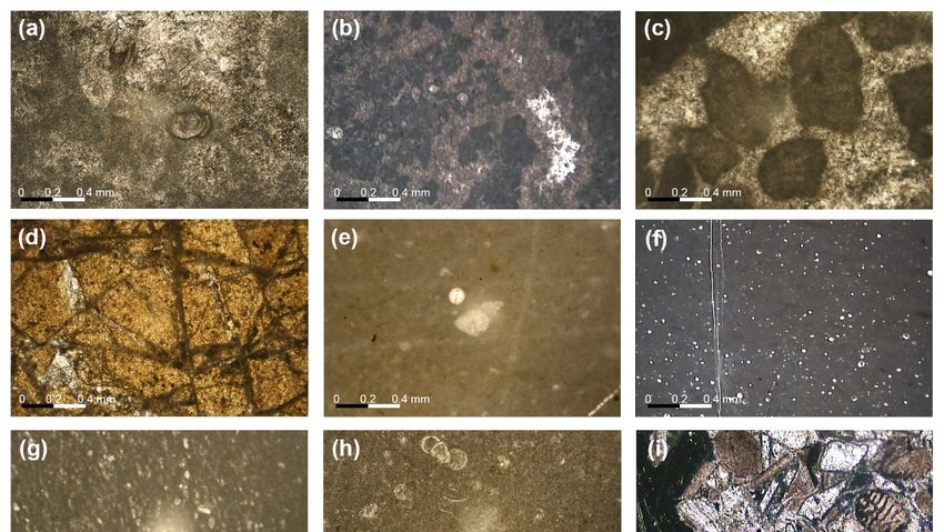
J.
J. Mar.
   Mar. Sci.
        Sci. Eng.
             Eng. 2020,
                  2020, 8,
                        8, x706
                             FOR PEER REVIEW                                                                                         55 of
                                                                                                                                        of 26
                                                                                                                                           25

sequence in the deeper part of the half-graben sub-basins begins with the Pliensbachian pelagic
Limestones
Siniais      and its lateral
        Limestones    and itsequivalent   Louros Limestones
                              lateral equivalent               (both indicative
                                                  Louros Limestones              of the first
                                                                        (both indicative      deepening
                                                                                           of the          event of
                                                                                                  first deepening
the Ionian
event       basin),
       of the       overlain
               Ionian         in some
                         basin),       sub-basins
                                  overlain  in someby sub-basins
                                                      the succession
                                                                   by “Ammonitico
                                                                       the succession Rosso”,   “Limestones
                                                                                         “Ammonitico          with
                                                                                                            Rosso”,
filaments”, and
“Limestones       “Upper
               with         Posidonia
                     filaments”,        Beds”, while
                                   and “Upper          in others,
                                                Posidonia   Beds”,thewhile
                                                                      “Ammonitico     Rosso”
                                                                           in others, the      is replacedRosso”
                                                                                          “Ammonitico        by the
coeval
is      “Lower
   replaced   by Posidonia
                 the coevalBeds”     in the
                                “Lower       previousBeds”
                                         Posidonia     sequence,
                                                             in theor previous
                                                                      even the whole   sequence
                                                                                sequence,    or evenis represented
                                                                                                         the whole
by the undifferentiated
sequence   is representedPosidonia      Beds [34,58]. The
                             by the undifferentiated        boundary
                                                        Posidonia       between
                                                                     Beds [34,58].the
                                                                                   ThePantokrator      Limestones
                                                                                        boundary between        the
and Louros or
Pantokrator     Siniais Limestones
              Limestones    and Louros is gradational.
                                          or Siniais Limestones is gradational.

     Figure 2.
     Figure       Google Earth
              2. Google    Earth maps
                                    maps of   of (A)
                                                  (A) Studied
                                                      Studied region
                                                                region in in Epirus
                                                                             Epirus (NW
                                                                                      (NW Greece)
                                                                                             Greece) into
                                                                                                       into the
                                                                                                            the red
                                                                                                                  red box;
                                                                                                                       box; (B)
                                                                                                                            (B) Agios
                                                                                                                                 Agios
     Georgios    section  (lat:   39 ◦ 160 14.99” N, lon: 20◦ 500 59.43” E); (C) Perivleptos section (lat: 39◦ 460 21.90” N,
     Georgios section (lat: 39°16′14.99″ N, lon: 20°50′59.43″ E); (C) Perivleptos section (lat: 39°46′21.90″, lon:
     lon: 20◦ 460 48.34”
     20°46′48.34″          E);Vigla
                     E); (D)    (D) Vigla
                                        (lat: (lat: 39◦ 480 33.45”
                                               39°48′33.45″         N, lon:
                                                              N, lon:        20◦ 430 38.73”
                                                                        20°43′38.73″         E), Asprageli-1
                                                                                       E), Asprageli-1    (lat: (lat: 39◦ 450 57.42”
                                                                                                                39°45′57.42″         N,
                                                                                                                                N, lon:
     lon:  20 ◦ 430 58.25”  E)  and    Asprageli-2      (lat: 39 ◦ 490 54.00” N,  lon:  20 ◦ 430 58.25”  E) sections;   (E) Koloniati
     20°43′58.25″ E) and Asprageli-2 (lat: 39°49′54.00″ N, lon: 20°43′58.25″ E) sections; (E) Koloniati section
     section
     (lat:     (lat: 39◦ 34N,
           39°34′52.46″
                            0 52.46” N, lon: 20◦ 530 11.41” E). The orange symbols mark the locations of the six
                                 lon: 20°53′11.41″ E). The orange symbols mark the locations of the six study
     study sections,
     sections,   and red and   red dashed
                           dashed                lines correspond
                                       lines correspond       to the to   the major
                                                                       major  studied studied
                                                                                        outcrops outcrops   respectively.
                                                                                                     respectively.
2.2.2. Vigla Formation
2.2.2. Vigla Formation
      This pelagic formation can be described as sub-lithographic thin-bedded to platy deposits, rich in
      This pelagic formation can be described as sub-lithographic thin-bedded to platy deposits, rich
plaktonic organisms (Calpionelles, Radiolaires, and Globotruncanes) of Cretaceous age. Their continuity
in plaktonic organisms (Calpionelles, Radiolaires, and Globotruncanes) of Cretaceous age. Their
is usually interrupted by thin intercalations, chert lenses, or even thin chert layers. Its dominant
continuity is usually interrupted by thin intercalations, chert lenses, or even thin chert layers. Its
lithology consists of light grey to yellowish micrites and radiolarian biomicrites (wackestones to
dominant lithology consists of light grey to yellowish micrites and radiolarian biomicrites
packstones). More explicitly, the calcareous beds (Vigla Limestones) of the lower part consist of
(wackestones to packstones). More explicitly, the calcareous beds (Vigla Limestones) of the lower
mudstones-wackestones, biomicrites with foraminifera and radiolaria, and siliceous wackestones and
part consist of mudstones-wackestones, biomicrites with foraminifera and radiolaria, and siliceous
packstones [42]. In the upper part, this formation consists of the Vigla Shale member (also known as
wackestones and packstones [42]. In the upper part, this formation consists of the Vigla Shale member
“Upper siliceous zone”; [66]) composed by yellow marly or shaly limestones and shales with chert
(also known as “Upper siliceous zone”; [66]) composed by yellow marly or shaly limestones and
intercalations, and red to green or locally black clay layers. The latter contains the equivalent of the
shales with chert intercalations, and red to green or locally black clay layers. The latter contains the
anoxic events of Selli (OAE1a) during the Aptian-Albian, Paquier Evet (OAE1b) of Early Albian age and
equivalent of the anoxic events of Selli (OAE1a) during the Aptian-Albian, Paquier Evet (OAE1b) of
Bonarelli (OAE2) at the Cenomanian-Turonian boundary in the Ionian zone [12,14,73,74], and extends
Early Albian age and Bonarelli (OAE2) at the Cenomanian-Turonian boundary in the Ionian zone
to Italy and Albania. Vigla Limestones generally feature considerable lateral variations in thickness,
[12,14,73,74], and extends to Italy and Albania. Vigla Limestones generally feature considerable
mainly in the basin borders where its thickness may reach the double of its average, which is indicative
lateral variations in thickness, mainly in the basin borders where its thickness may reach the double
of persistent differential subsidence [34,58,59]. In the internal sub-basin, the Vigla Limestones consist
of its average, which is indicative of persistent differential subsidence [34,58,59]. In the internal sub-
of compact, thick-bedded, often bituminous, dolomitic limestones, with lenses of slightly dolomitized
basin, the Vigla Limestones consist of compact, thick-bedded, often bituminous, dolomitic
microbreccia and thin cherty intercalated layers or nodules. It is also characterized by the presence of
limestones, with lenses of slightly dolomitized microbreccia and thin cherty intercalated layers or
several aptychus in its lower part [59,64]. In Epirus, along the eastern border of the central Ionian zone,
nodules. It is also characterized by the presence of several aptychus in its lower part [59,64]. In Epirus,
phosphatic horizons are intercalated with the uppermost horizons of the Vigla Limestone formation,
along the eastern border of the central Ionian zone, phosphatic horizons are intercalated with the
stratigraphically above the Vigla Shale member. Overall, this formation corresponds to the first post-rift
uppermost horizons of the Vigla Limestone formation, stratigraphically above the Vigla Shale
sediments of the Ionian zone [58,59,64].
member. Overall, this formation corresponds to the first post-rift sediments of the Ionian zone
[58,59,64].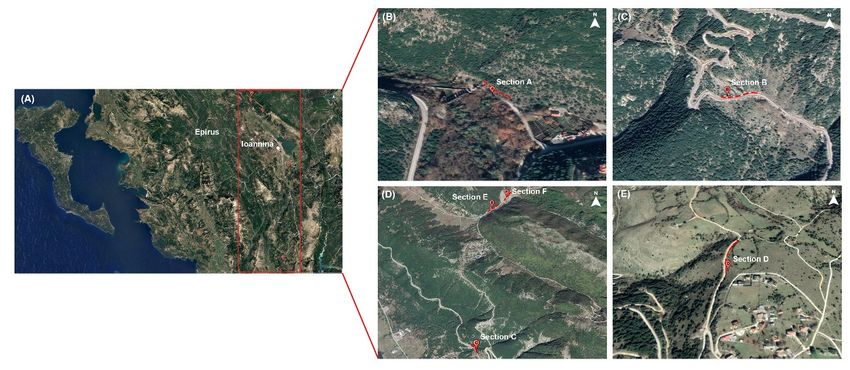
J. Mar. Sci. Eng. 2020, 8, 706                                                                              6 of 25

2.2.3. Senonian Limestones
       This formation corresponds to thick pelagic strata (1 to 3 m) intercalated with calciturbidites,
comprising limestones with fragments of globotruncanids and rudists and fine-grained breccia
intervals with limestones and rudist fragments within calcareous cement containing pelagic fauna.
Calciturbidites are usually alternated with sub-lithographic pelagic limestones and cherts [34,35].
Overall, this formation corresponds to a period of basinal sedimentation, with significant variations of
its lithological characteristics and sedimentary facies from the external (western) to the internal (eastern)
parts of the Ionian basin. In the external sub-basin, they have been described as “clastic limestones” [75]
containing floatstones, rudstones and rare grainstones and packstones with a micritic matrix, biomicritic
intercalations, and rare cherty nodules. In the middle sub-basin, these carbonates are characterized as
microclastic, bioclastic or polygenic microbreccias with a micritic matrix (wackestone, packstones),
intercalated with (bio)micrites. In the internal sub-basin, the Senonian Limestones are massive,
thick bedded microbrecias to breccias containing rudists and coral fragments, with only local appearance
of thin-bedded or nodular chert [65,66,76].

2.2.4. Paleocene-Eocene Limestones
     This formation also known as “Limestones with microbreccia” [75] is characterized by the same
sedimentary facies with the underlying formation, with prominent microbreccia derived from the
erosion of Cretaceous carbonates from both the Gavrovo (to the east) and Apulian (to the west)
platforms. On Late Paleocene and progressively through the Early Eocene, the supply of calciclastic
material diminished significantly, especially in the central Ionian Basin. The main depositional facies
during the Eocene were platy wackestone and mudstone with Globigerinidae and chert nodules,
analogous to those of the Vigla Limestones, but lack continuous siliceous intervals [34].

3. Materials and Methods
       Six sections (A–F; Figure 2A–E) were sampled every 1 m and studied in terms of their reservoir
parameters, paleodeposition environment, and paleogeographic significance.
       Section A (Agios Georgios Section) is situated at the entrance of Agios Georgios village
(lat: 39◦ 160 14.99” N, lon: 20◦ 500 59.43” E; Figure 2B). This section belongs to the Pantokrator Limestones
(Figure 3), with a total length of 50 m, where 50 samples have been collected (Figure 4).
       Section B (Perivleptos section) is situated at the north part of Perivleptos village (lat: 39◦ 460 21.90” N,
lon: 20◦ 460 48.34” E; Figure 2C). This section covers parts of Pantokrator Limestones and Vigla Shales
(Figure 3). The total length of the section is 20 m, where 20 samples have been collected (Figure 4).
       Section C (Vigla Section) is situated at the south part of Asprageli village (lat: 39◦ 480 33.45” N,
lon: 20◦ 430 38.73” E; Figure 2D). This section covers partially the Vigla Limestones (Figure 3) with a
total length of 20 m, where 20 samples have been collected (Figure 4).
       Section D (Koloniati section) is situated at the north part of Koloniati village (lat: 39◦ 340 52.46” N,
lon: 20◦ 530 11.41” E; Figure 2E). This section covers the upper part of the Vigla Limestones and the
lower part of the Senonian Limestones, which are separated by an unconformity (Figure 3). The total
length of the section is 60 m, where 30 samples have been collected every 2 m (Figure 4).
       Section E (Asprageli-2 Section) is situated at the north-east part of Asprageli village, near the
section C (lat: 39◦ 490 54.00” N, lon: 20◦ 430 58.25” E; Figure 2D). This section covers the Senonian
Limestones (Figure 3), with a total length of 10 m, where 10 samples have been collected (Figure 4).
       Section F (Asprageli-1 Section) is situated at the north-east part of Asprageli village
(lat: 39◦ 450 57.42” N, lon: 20◦ 430 58.25” E; Figure 2D). This section covers the part of Paleocene-Eocene
limestones (Figure 3), with a total length of 25 m, where 25 samples have been collected (Figure 4).
J. Mar. Sci. Eng. 2020, 8, 706 7 of 25
J. Mar. Sci. Eng. 2020, 8, x FOR PEER REVIEW 7 of 26
Figure3.3.Synthetic
Figure Synthetic lithostratigraphic
lithostratigraphiccolumn columnofof thethe
Ionian zone
Ionian (modified
zone fromfrom
(modified [34]),[34]),
alongalong
with the
with
thecorrespondence
correspondence of of
study
studysections
sections stratigraphy
stratigraphy with
with Ionian formations
Ionian formations andandtheir average
their average porosity
porosity
values
values asaspotential
potentialreservoir
reservoirrocks.
rocks.TheThe colors
colors in the lithostratigraphic
lithostratigraphiccolumn
columnare areconsistent
consistent with thethe
with
relevantcolors
relevant colorsofofthe
theInternational
InternationalChronostratigraphic
Chronostratigraphic Chart Chart(v2020/01).
(v2020/01).(1) (1)Shales
Shalesandand sandstones;
sandstones;
(2)(2)limestones
limestoneswithwith rare
rare cherty
chertyintercalations,
intercalations, occasionally
occasionally microbreccious; (3) pelagic
microbreccious; limestones
(3) pelagic with
limestones
clastic
with platform
clastic platformelements; (4) pelagic
elements; limestones
(4) pelagic with cherts;
limestones (5) cherty
with cherts; beds with
(5) cherty bedsshale
withand marl
shale and
intercalations;
marl (6) (6)
intercalations; pelagic limestones
pelagic limestones with cherty
with nodules
cherty andand
nodules marls; (7)(7)
marls; pelagic
pelagiclimestones
limestones with
with
bivalves;(8)
bivalves; (8)pelagic,
pelagic,nodular
nodular redred limestones
limestones withwith ammonites;
ammonites; (9) (9)marly
marlylimestones
limestonesand andlaminated
laminated
marls; (10) conglomerates-breccias and marls with ammonites; (11) pelagic limestones withwith
marls; (10) conglomerates-breccias and marls with ammonites; (11) pelagic limestones rare
rare cherty
cherty intercalations; (12) external platform limestones with brachiopods and
intercalations; (12) external platform limestones with brachiopods and small ammonites in upper part; small ammonites in
upper part; (13) platform limestones; (14) thin-bedded black limestones;
(13) platform limestones; (14) thin-bedded black limestones; (15) evaporites; (16) shales. (15) evaporites; (16) shales.
J. Mar. Sci. Eng. 2020, 8, 706 8 of 25
J. Mar. Sci. Eng. 2020, 8, x FOR PEER REVIEW 8 of 26
Figure
Figure 4. 4.Lithology
Lithology of
of the
the 66 study
studysections
sectionsinin
Epirus
Epirusregion. The The
region. orange and blue
orange and circles at the right
blue circles at the
of each column represent the sampling intervals for thin sections as well as porosity and
right of each column represent the sampling intervals for thin sections as well as porosity and bulk density
bulk
measurements.
density measurements.
TheThe study
study ofof theJurassic
the JurassictotoEocene
Eocenesediments’
sediments’ distribution
distribution was
was based
basedon ontectonic,
tectonic,stratigraphic,
stratigraphic,
paleontologic,and
paleontologic, and sedimentologic
sedimentologic observations.
observations.Depending
Dependingmostly
mostly on on
outcropping
outcropping conditions, an
conditions,
an average
averagesampling
samplinginterval
intervalofofapproximately
approximately11mmhas hasbeen
beenused.
used.An
Anoverall
overallnumber
numberofof150 150samples
samples
were
were collected,
collected, amongwhich
among which7070usedusedforforsedimentary
sedimentary facies
facies analysis
analysis and
and 50
50for
formeasuring
measuringporosity
porosity
and bulk density. Microfacies definition and textural characters analysis of thecarbonate
and bulk density. Microfacies definition and textural characters analysis of the carbonaterocks,
rocks,
including
including bothbiogenic
both biogenicand andinorganic
inorganicdominant
dominant components,
components, werewere done
done according
accordingtotocarbonate
carbonate
classification
classification schemesofof[77],
schemes [77],which
whichlater
latermodified
modified by by [78],
[78], based
based on
on the
theStandard
StandardMicrofacies
MicrofaciesTypesTypes
(SMF) in the facies zones (FZ) of the rimmed carbonate platform model. Depositionalenvironments
(SMF) in the facies zones (FZ) of the rimmed carbonate platform model. Depositional environments
were
were reconstructedbased
reconstructed basedononthe thederived
derivedsedimentological
sedimentological features
features and
and through
throughcomparison
comparisonwith with
additional standard facies reconstructions [79–85]. Therefore, assemblages consisting of several SMF
additional standard facies reconstructions [79–85]. Therefore, assemblages consisting of several SMF
types characterize all depositional environments. Thin sections were prepared in the Historical
types characterize all depositional environments. Thin sections were prepared in the Historical
Geology and Paleontology Laboratory (National and Kapodistrian University of Athens; NKUA),
Geology and Paleontology Laboratory (National and Kapodistrian University of Athens; NKUA),
biostratigraphically and sedimentologically studied under a polarized LEICA DM LP microscope,
biostratigraphically and sedimentologically studied under a polarized LEICA DM LP microscope,
and photos have been performed with OLYMPUS UC30 Microscope Digital Camera. The reservoir
and photos have been performed with OLYMPUS UC30 Microscope Digital Camera. The reservoir
potential of these carbonates was also obtained through the examination of porosity and bulk density
potential of these carbonates was also obtained through the examination of porosity and bulk density
parameters on representative of each stratigraphic formation samples, with the use of GeoPyc 1360
parameters
Envelope on representative
Density Analyzer and of each stratigraphic
helium AccuPyc 1330 formation samples,
Pycnometer, with the use
respectively, alsoof
atGeoPyc
NKUA. 1360All
Envelope Density Analyzer and helium AccuPyc 1330 Pycnometer, respectively,
measurements were made on dry samples that were previously dried in the oven at 40 °C for 24 h. also at NKUA.
AllThe
measurements were made on dry samples that were previously dried inregional
the oven at 40 ◦ C for 24 h.
petroleum potential information was further compared with existing data covering the
The petroleum
studied potential
stratigraphic information
interval. Finally,was further
ArcGIS compared
software with to
was used existing regional
visualize data of
the results covering
the study the
studied stratigraphic
area, along interval.data
with additional Finally,
known ArcGIS
from thesoftware wasoutcropped
literature, used to visualize
and wellthedata
results of the study
[33,35,42,59,86]
area, along with additional data known from the literature, outcropped and well
expanding the entire Ionian zone within paleogeographic/paleoenvironmental maps for the relevant data [33,35,42,59,86]
expanding the entire Ionian zone within paleogeographic/paleoenvironmental maps for the relevant
time interval.
time interval.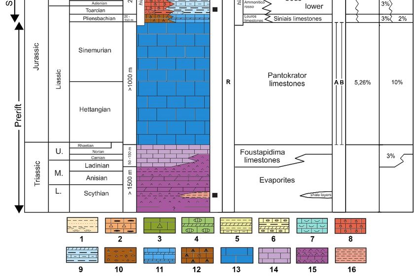
J. Mar. Sci. Eng. 2020, 8, 706                                                                                    9 of 25

     J. Mar. Sci. Eng. 2020, 8, x FOR PEER REVIEW                                                            9 of 26
4. Results
     4. Results
4.1. Description of the Study Sections
     4.1. Description
      Figure          of the Study
               5 illustrates       Sections view of the studied sections, regarding the Jurassic-Eocene
                                a general
carbonates    of the
          Figure       Ionian zone
                  5 illustrates        in theview
                                 a general      study   area.studied
                                                    of the     Agios sections,
                                                                      Georgiosregarding
                                                                                   section consists      of 50 m of a
                                                                                              the Jurassic-Eocene
uniform,    largely
     carbonates       condensed
                 of the Ionian zoneshallow-water
                                     in the study area.limestone    unit section
                                                         Agios Georgios    (Figureconsists
                                                                                     5a,b) with
                                                                                             of 50 mcalcareous    algae,
                                                                                                      of a uniform,
     largely
benthic       condensed and,
         foraminifera,     shallow-water    limestone The
                                rarely, brachiopods.     unitmiddle
                                                               (Figurepart
                                                                        5a,b)of with  calcareous (samples
                                                                                this succession     algae, benthic
                                                                                                              L15–L20)
     foraminifera, and
is recrystallized   and,slightly
                          rarely, brachiopods.
                                  dolomitized,The      middle part of
                                                   a phenomenum          thisusually
                                                                      that     succession   (samples
                                                                                      occurred         L15–L20)
                                                                                                  during           is
                                                                                                           the Jurassic
     recrystallized  and slightly dolomitized,   a phenomenum      that usually  occurred   during
in the Ionian zone. Such Early Jurassic sediments represent the lower part of the carbonate unit     the Jurassic in
     the Ionian
in western       zone. The
              Greece.   Suchbasal
                              Early10Jurassic  sediments represent
                                        m of Perivleptos      section the  lower neritic
                                                                      contains     part of Pantokrator
                                                                                            the carbonateLimestones,
                                                                                                            unit in
     western Greece. The basal 10 m of Perivleptos section contains neritic Pantokrator Limestones,
overlain unconformably by reddish and green organic matter-rich shales with thin- to medium-bedded
     overlain unconformably by reddish and green organic matter-rich shales with thin- to medium-
marly limestone interbeds and siliceous lenses, the Vigla Shales (Figure 5c–e).
     bedded marly limestone interbeds and siliceous lenses, the Vigla Shales (Figure 5c–e).

           Figure 5. Outcrop photographs of the study sections along with enlargements indicative of their
      Figure 5. Outcrop photographs of the study sections along with enlargements indicative of their
           characteristics: (a) General panoramic view of the Agios Georgios section; (b) Early Jurassic
      characteristics: (a) General panoramic view of the Agios Georgios section; (b) Early Jurassic Pantokrator
           Pantokrator Limestones of Agios Georgios section; (c) general panoramic view of Perivleptos section.
      Limestones of Agios Georgios section; (c) general panoramic view of Perivleptos section. The red dashed
           The red dashed line marks the unconformity between the lower (Pantokrator Limestones) and the
      line marks the unconformity between the lower (Pantokrator Limestones) and the upper (Vigla Shales)
      part of the section; (d) Pantokrator Limestones of the lower part of Perivleptos section; (e) Vigla Shales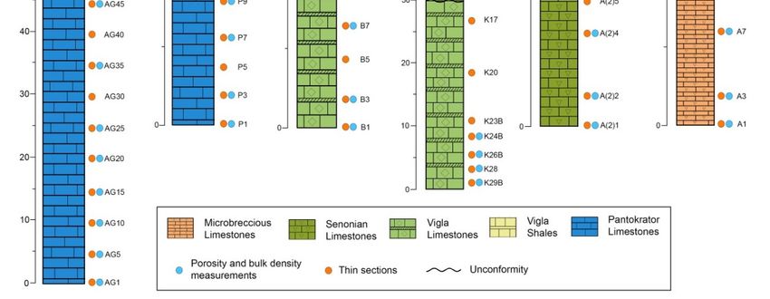
J. Mar. Sci. Eng. 2020, 8, 706                                                                               10 of 25

      of the upper part of Perivleptos section; (f) general panoramic view of Vigla section; (g) enlargement of
      the Vigla section, showing pelagic limestones and with chert intercalations; (h) general panoramic view
      of Koloniati section; (i) Vigla Limestones of the lower part of Koloniati section. The red dashed line
      marks the unconformity between the lower (Vigla Limestones) and the upper (Senonian Limestones)
      part of the section; (j) Senonian Limestones of the upper part of Koloniati section; (k) enlargement
      of the Vigla Limestones, showing pelagic limestones intercalated with flattened cherty nodules;
      (l) general panoramic view of Asprageli-2 section; (m) Senonian Limestones of Asprageli-2 section;
      (n) general panoramic view of Asprageli-1 section; (o) Paleocene-Eocene microbrecciated limestones of
      Asprageli-1 section.

     The Vigla section, which has a thickness of 20 m, is characterized by typical Vigla formation
deposits, such as pelagic limestones interbedded with centimeter- to decimeter-thick radiolarian chert
beds (Figure 5f,g). Koloniati section (60 m thickness) consist of Cretaceous deposits of both Vigla and
Senonian Limestones formations separated by an unconformity (Figure 5i). The lower half consists of
pelagic massive limestones with rare intercalations of chert beds, and spherical, but also flattened, cherty
nodules (Figure 5i,k). The siliceous nodules are beige, or light grey to dark grey color. The lithology of
the upper half is described as solid, thick-bedded limestones that can be easily separated from the
underlain thin-bedded ones (Figure 5j). In the uppermost part of the section brecciated horizons have
been observed. Similar microbreccia bioclastic limestones with roudist fragments were observed in the
10 m thick Asprageli-2 section (Figure 5l,m). Finally, at the top of the studied carbonate succession,
the 25 m thick Asprogeli-1 section consists of grey-light micro- to mesoporous, turbiditic limestones
with abundant radiolaria and planktonic foraminifera (Figure 5n,o).

4.2. Sedimentary Facies Analysis
      Section A (Agios Georgios Section): The principal lithofacies of this section is boundstone,
composed of red algal communities, and less frequent benthic foraminifera within a micritic clotted
matrix (Figure 6a,b). Some lime horizons are dolomitized.
      Section B (Perivleptos section): The lower part of this section is characterized by the lithofacies
recrystallized grainstone of peloids with signals of dolomitization and fracturing (Figure 6c,d),
while the upper part consists of mudstone-wackstone with radiolarians and/or planktonic foraminifera
(Figure 6e).
      Section C (Vigla Section): Section E consists of radiolarian biomicrite wackstone (Figure 6f,g).
      Section D (Koloniati section): Within this section biomicrite mudstone-wackstone with planktonic
foraminifera (Figure 6h), allochtonous bioclastic packstone with abundant benthic foraminifera
(Figure 6i), and ooid lithofacies (Figure 6j,k) were observed.
      Section E (Asprageli-2 Section): In Section D, the following two lithofacies have been observed:
(i) bioclastic packstone, (Figure 6l), and (ii) biomicrite wakstone-packstone-floatstone with planktonic
foraminifera, (Figure 6m).
      Section F (Asprageli-1 Section): In Section C a packstone with planktonic foraminifera and some
scattered mollusc and benthic foraminifera (Figure 6n,o) has been identified.
      Generally, high energy environments such as platform, fore-shoal, and intertidal channel display
grain supported textures. On the contrary, in low energy environments such as deep shelf and open
marine, mud supported textures developed. In between, medium energy settings include platform slope
environments, deposits of which are characterized by significant debris of rudists, algae, porcelaneous
benthic foraminifera, and rarely variable shell fragments (bivalves, bryozoans). Grainy or micritic
texture also strongly affected porosity, fluid flow, and diagenetic processes.

4.3. Biostratigraphic Analysis
     Section A (Agios Georgios Section): Calcareous green algae of Paleodasycladus sp. and
Paleodasycladus mediterraneus and Thaumatoporella parvovesiculifera, Thaumatoporella sp. build
boundstones. Benthic foraminifers are represented by Textularia sp., Miliolidae and Ataxophragmiidae.
J. Mar. Sci. Eng. 2020, 8, 706 11 of 25
J. Mar. Sci. Eng. 2020, 8, x FOR PEER REVIEW 11 of 26
Figure6.6.Characteristic
Figure CharacteristicEarly
EarlyJurassic
Jurassic to
to Paleogene
Paleogene microfacies types of
microfacies types of Ionian
Ionian zone
zone(Epirus
(Epirusregion,
region,
NWNWGreece).
Greece).(a,b)
(a,b)Dolomized
Dolomizedboundstone
boundstone withwith calcareous
calcareous algae and benthic foraminifera
foraminifera within
withinaa
micritic
micriticclotted
clottedmatrix
matrix (samples AG1, AG15);
(samples AG1, AG15);(c,d)(c,d)recrystallized
recrystallizedgrainstone
grainstone of of peloids
peloids with
with signals
signals of
ofdolomitization
dolomitizationand andfracturing
fracturing(samples
(samplesP3, P3,P9);
P9); (e)
(e) mudstone-wackestone
mudstone-wackestonewith with radiolarian
radiolarian and
and
planktonicforaminifera
planktonic foraminifera (sample
(sample P19);
P19); (f,g)(f,g) wackestone
wackestone withwith radiolarians
radiolarians (samples(samples B1,(h)
B1, B10); B10); (h)
Pelagic
Pelagic wackestone
wackestone with radiolarians
with radiolarians and planktonic
and planktonic foraminiferaforaminifera (sample
(sample K2); K2); (i) Allochthonous
(i) Allochthonous bioclastic
bioclastic packstone
packstone with medium-with medium- and large-sized
and large-sized bioclastsbioclasts
benthics benthics and rudist
and rudist fragments
fragments (sample
(sample K5);
K5);grainstone
(j,k) (j,k) grainstone
of ooidsof ooids
with withcement
sparitic sparitic cementK4,
(samples (samples K4, K9); packstone
K9); (l) bioclastic (l) bioclastic packstoneand
of orientated of
orientated larger
transported and transported larger benthic
benthic foraminifera foraminifera
and rudists (sampleand rudists
A(2)7); (samplewackestone-packstone
(m) Pelagic A(2)7); (m) Pelagic
ofwackestone-packstone
radiolarian and planktonic of radiolarian and planktonic
foraminifera, among which foraminifera, among
carenate forms arewhich carenate
presented forms
(sample are
A(2)9);
presented
(n,o) packstone(sample A(2)9);
with in (n,o) packstone
situ planktonic with and
foraminifera in situ planktonic
scattered, foraminifera
transported benthicsand
and scattered,
molluscks
transported
(samples benthics and molluscks (samples A7, A13).
A7, A13).
Section
SectionBB (Perivleptos section):The
(Perivleptos section): Benthic
lower foraminifera Glomospira
(e.g., is
part of this section Glomospirella
sp., by
characterized sp.,
the lithofacies
Globochaete
recrystallized Textularia sp.,
sp.,grainstone Valvulina
of peloids withsp., Miliolidae,
signals Clypeina jurassica,
of dolomitization Protopeneroplis
and fracturing striata)
(Figure 6c,d), and
whileJ. Mar. Sci. Eng. 2020, 8, 706 12 of 25
fragments of hermatypic corals, calcareous green algae, gastropods, were identified in the lower part
of the section and suggest a Hettangian-Sinemurian age. Radiolarians and planktonic foraminifera
Ticinella roberti, Biticinella breggiensis, Hedbergella delrioensis, Hedbergella planispira, place the upper part
of this section to the Middle-Late Albian.
Section C (Vigla Section): Assemblages of small-to-medium-sized morphotypes of Calpionella alpina
followed by the acme of Calpionella elliptica at the basal part of the section suggest an Early
Berriasian age, while progressively through the top of the section radiolarians and other planktonics
(Favusella hauterivica, Hedbergella sigali, Hedbergella dendroensis) have been further identified. In the
upper half of the section the Globigerinelloides “acme” and “eclipse” intervals, characterized by the
abundant presence and the lack of representatives of this genus, respectively, show the evolution
through the Barremian up to the Albian in the topmost meters of the Vigla Limestones.
Section D (Koloniati section): The lower part of the section assigned to Vigla Formation was
characterized by the presence of the planktonic foraminiferal assemblage Rotalipora appenninica,
Rotalipora cushmani, and Praeglobotruncana gibba suggesting the early Late Cretaceous and particularly
the Cenomanian-Turonian boundary interval. The upper part has a Coniacian-Maastrichtian age and
contains the foraminifera Globotruncana cf. arca, Globotruncana cf. linnei, Orbitoides sp., Quinqueloculina sp.,
Spiroloculina sp., Pseudolituonella sp., Cuneolina sp., Textulariidae, and Miliolidae.
Section E (Asprageli-2 Section): This section cover the Santonian-Maastrichtian time span based
on the variable fauna containing mainly Globotruncaniids (e.g., Globotruncanita stuarti stuatiformis,
Rugoglobigerina rugosa, Globotruncana cf. bulloides, Globotruncana arca, Abathomphalus mayaroensis,
Contusotruncana sp.), but also benthic foraminifera (e.g., Miliolidae, Siderolites sp., Cuneolina sp.,
Orbitoides cf. media, Orbitoides apiculata), as well as rudist and molusc fragments.
Section F (Asprageli-1 Section): The genera Subbotina, Acarinina, and Morozovella are the
dominant groups of Paleocene-Early Eocene assemblages. More explicitly, the lower part of the section
contains carbonates enriched on radiolarians and planktonic foraminifera (Parasubbotina pseudobulloides,
Acarinina sp., Subbotina sp., Igorina pussila, Chiloguembelina sp.), which deposited during the
Early Paleocene (Selandian). Progressively through the top of the section, the increase of
highly and full body ornamented Morozovellid species (e.g., Morozovella aequa and Morozovella
subbotinae, Morozovella velascoensis) and quadrate Acarininids (e.g., Acarinina wilcoxensis and
Acarinina pseudotopilensis) are indicative to the end of the Paleocene and the start of the Eocene (Ypresian).
Overall, the age determination supports the pre-existing results mentioned in the geological maps
(Ioannina, Doliana, Pappadatai, and Tsepelovo sheets; [87–90]) regarding the Ionian zone rock exposures.
Particularly, they confirm the Early Jurassic (Hettangian-Sinemurian) for the Pantokrator Limestones,
the Early Cretaceous-early Late Cretaceous (Berriasian-Turonian) for the Vigla Limestones, the early Late
Cretaceous (Albian) for the Vigla Shales, the Late Cretaceous (Coniasian-Maastrichtian) for the Senonian
Limestones, and the Paleocene/Early Eocene age for the microbreccious limestones respectively.
4.4. Porosity and Bulk Density Measurements
The results of porosity and bulk density measurements of the studied carbonates are listed
in Table 1, while the average values per formation in Table 2. With the exception of Vigla Shales,
which present the lowest measured bulk density values (2.60–2.63; average 2.62 gr/cm3 ), the bulk
density is quite homogeneous for all carbonate samples, ranging from 2.64 to 2.74 gr/cm3 , with an
average of 2.68–2.70 gr/cm3 , respectively, per study formation (Table 2). On the contrary the total
porosity values evaluated with the pycnometer present significant variability between the different
sections and stratigraphic formations. In Agios Georgios section porosity values range between 2.31%
and 9.71%, with an average value of 4.97% (Table 1). Significant porosity values above the average value
for the Jurassic deposits were recorded in some horizons of this unit (samples AG10-20), where the
limestones seem to be dolomitized. These values approximate the maximum porosities (~10%) that
have been reported for this formation for the entire Ionian zone [33]. The total average porosity for theJ. Mar. Sci. Eng. 2020, 8, 706 13 of 25
Pantokrator Limestones, including both Agios Georgios and the lower part of Perivleptos sections,
is 5.26% (Table 2).
Table 1. Porosity and bulk density measurements displayed from all the study sections.
Section Formation Sample ID Height (m) Porosity (%) Bulk Density (g/cm3 )
A1 0 9.35 2.64
A3 2 3.90 2.61
A7 6 7.38 2.65
Section F Limestones with A10 9 8.55 2.68
(Asprageli-1) breccia A13 12 2.50 2.71
A19 18 3.46 2.67
A23 22 4.32 2.72
A25 24 5.60 2.74
A(2)1 0 3.31 2.72
A(2)2 1 4.52 2.72
A(2)4 3 2.60 2.74
Section E Senonian
A(2)7 6 8.64 2.69
(Asprageli-2) Limestones
A(2)8 7 9.63 2.73
A(2)9 8 7.36 2.62
A(2)10 9 8.99 2.70
K1 0 8.88 2.69
K3 4 9.26 2.68
Senonian K5 8 5.47 2.69
Limestones K8 14 3.86 2.72
Section D K11 20 6.56 2.72
(Koloniati) K15 26 5.46 2.72
K28 52 1.28 2.67
K24B 44 2.33 2.69
Vigla Limestones
K26B 48 3.87 2.69
K29B 54 5.65 2.69
B1 0 3.36 2.73
B3 2 3.86 2.70
B7 6 1.81 2.71
Section C B10 9 3.52 2.68
Vigla Limestones
(Vigla) B14 13 2.45 2.71
B18 17 2.07 2.73
B20 19 2.98 2.69
Π20 19 6.00 2.63
Π18 17 8.10 2.60
Vigla Shales Π15 14 5.82 2.62
Section B Π12 11 3.38 2.61
(Perivleptos) Π9 8 8.18 2.72
Pantokrator Π7 6 7.67 2.72
Limestones Π3 2 3.75 2.72
Π1 0 4.02 2.66
AG1 0 2.49 2.70
AG5 4 3.55 2.73
AG10 9 9.71 2.72
AG15 14 9.62 2.68
Section A Pantokrator AG20 19 7.56 2.69
(Agios Georgios) Limestones AG25 24 3.28 2.73
AG35 34 2.31 2.70
AG45 44 3.76 2.65
AG50 49 2.45 2.66
Porosity measurements of the Perivleptos section document steadily high values for both
lithostratigraphic members, with quite similar values (3.75–8.18%, average 5.91%; Table 1) for the
basal Jurassic interval and the overlying Vigla Shales (3.38–8.10%, average 5.83%; Table 1). On theJ. Mar. Sci. Eng. 2020, 8, 706 14 of 25
contrary, the typical Vigla Limestones in both Vigla section and the lower part of Koloniati outcrop
display the lowest values ranging between 1.81% and 3.86% (average 2.86%) in the former and 1.28%
and 5.65% (average 3.28%) in the latter (Table 1). Overall, the average porosity for Vigla Limestones,
taking into account the data from both aforementioned areas, equals to 3.02% (Table 2). The analyzed
samples from the upper part of Koloniati section characterized as Senonian Limestones showed
steadily high porosity in the range of 3.86% to 9.26% (average 6.58%), especially at the top of this
unit, where brecciated limestones with the maximum porosities of about 10% were identified (Table 1).
The same range showing the tendency for increased porosity values (2.60–9.63%, average 6.44%; Table 1)
was observed in Asprageli-2 section, with the hemipelagic calciturbidites and fractured resedimented
microbreccia. The total average porosity measured for this Late Cretaceous carbonate unit is 6.50%
(Table 2). The porosity of Asprageli-1 brecciated Paleogene limestones is in the range of 2.50–9.35%
(Table 1), with the average of 5.63% (Table 2).
Table 2. Average porosity and bulk density values per studied formation of the Ionian zone.
Formation Stratigraphy Average Porosity (%) Average Bulk Density (gr/cm3 )
Limestones with miccrobreccia Paleocene/Eocene 5.63 2.68
Senonian calciturbidites Late Cretaceous 6.50 2.70
Vigla Shales late Early Cretaceous 5.83 2.62
Vigla Limestones Early Cretaceous 3.02 2.70
Pantokrator Limestones Early Jurassic 5.26 2.70
5. Discussion
5.1. Microfacies Types and Depositional Environments
The main textural and compositional characteristics, as well as the sedimentary features of
the distinguished microfacies, are summarized in Table 3, corresponding to different depositional
environments or facies zones (FZ) defined by [84,85] (Figure 7). More specifically, the Pantokrator
Limestones were classified as boundstone of algae (SMF 7) and bioclastic grainstone (SMF 11)
in the Agios Georgios and Perivleptos sections respectively, giving evidence of a depositional
environment characterized by a platform, with both intertidal and subtidal environments (FZ5-6).
Recrystallization-dolomitation and fracturing of some redeposited carbonate clasts points a subaerial
exposure of parts of the platform. Vigla Limestones consist of mudstone-wackestone with radiolarians
and planktonic foraminifera (SMF 2-3), characterizing a low energy, relatively deep environment,
such as the toe of slope (FZ3) and/or deep shelf (FZ2). Senonian Limestones present a variety of
lithofacies, which correspond to environments ranging from the slope to deep shelf. They mostly
include in-situ wackestone-packstone with planktonic foraminifera along with microbreccia bioclastic
packstone with fragments of shallow water fauna (rudists and benthic foraminifera) (SMF 4), and micrite
with transported ooids (SMF 13), which in total represent a medium-to-high-energy environment
(e.g., slope), possibly due to the transportation of the sediments within the basin from the platform.
The above facies distribution reflects the separation of the deep Ionian Basin into a central
topographically-higher area characterized by reduced sedimentation, and two surrounding talus
slopes with increased sedimentation [66]. Locally, micritic peloids and dark-gray intraclasts, floating in
an overall micritic matrix were also observed within these carbonates. The range of depositional
interpretations of these formations includes supratidal settings, vadose-marine inorganic precipitation
in inter- and subtidal environments of formation in marine seepage or groundwater springs [85].
Overall, Late Cretaceous calciturbidites suggest relatively deep-slope depositional conditions (FZ3-4).
Relatively similar and possibly deeper depositional conditions apply for the Paleogene biomicritic
packstones with radiolaria (mostly at the Early Paleocene) and planktonic foraminifera (through the
Eocene) (SMF3), suggesting a basinal environment (FZ2).J. Mar. Sci. Eng. 2020, 8, 706 15 of 25
Table 3. Detailed description of representative thin sections, where sedimentary facies, lithology, formation, age, and the depositional environments of the studied
deposits are presented.
Section Samples Formation Lithology Facies Description Figures Depositional Environment Stratigraphy (Stages)
Hemipelagic Packstone with in-situ planktonic
Limestones with Shelf slope (FZ3) to deep shelf
F: Asprageli-1 A7, A13 calciturbidites with foraminifera and scattered, benthic Figure 6n,o Paleocene to Eocene
microbreccia (FZ2) (medium energy)
microbreccia foraminifera and molluscks (SMF 3)
(a) Allochtonous bioclastic
packstone with rudists and benthic
Miccrobrecciated Slope (FZ4) - toe of slope (FZ 3) to
Senonian foraminifera (SMF 5), (b) Pelagic Late Cretaceous
E: Asprageli-2 A7, A9 bioclastic to pelagic Figure 6l,m deep shelf (FZ 2)
Limestones wackestone-packstone with (Santonian-Maastrichtian)
turbiditic limestones (medium energy)
radiolarian and planktonic
foraminifera (SMF 4-5)
(a) Allochtonous bioclastic
packstone to grainstone with rudist
fragments and benthic foraminifera
D: Koloniati Senonian Bioclastic Limestones Slope (FZ 4) (medium to Late Cretaceous
K2, K9, K4, K5 (SMF 5), (b) Mudstone-wackestone Figure 6h,i,j,k
(upper part) Limestones (often brecciated) high energy) (Santonian-Maastrichtian)
with planktonic foraminifera (SMF
4-5), (c) Grainstone of ooids with
sparite cement (SMF 5)
C: Vigla, D: Early Cretaceous-early
Limestones intercalated Wackestone with radiolarians and
Koloniati B1, B10 Vigla Formation Figure 6f,g Toe of slope (FZ 3) (low energy) Late Cretaceous
with cherts planktonic foraminifera (SMF 3)
(lower part) (Berriasian-Turonian)
Shales with marly Mudstone-wackestone with late Early Cretaceous-early
B: Perivleptos
P19 Vigla Formation limestone interbeds and radiolarians and planktonic Figure 6e Deep shelf (FZ 2) (low energy) Late Cretaceous
(upper part)
siliceous nodules foraminifera (SMF 3) (Aptian-Turonian)
Recrystallized grainstone of peloids Inner platform with interdital
B: Perivleptos Pantokrator Early Jurassic
P3, P9 Neritic limestones with lithoclasts (SMF 5). Signals of Figure 6c,d and subtidal environments (FZ 4)
(lower part) Limestones (Hettangian-Sinemurian)
dolomitization and fracturing (moderate energy)
Dolomized boundstone with
Pantokrator Limestones locally calcareous algae and benthic Early Jurassic
A: Agios Georgios AG1, AG15 Figure 6a,b Platform (FZ 5) (high energy)
Limestones dolomitized foraminifera within a micritic clotted (Hettangian-Sinemurian)
matrix (SMF 7)environment, such as the toe of slope (FZ3) and/or deep shelf (FZ2). Senonian Limestones present a
variety of lithofacies, which correspond to environments ranging from the slope to deep shelf. They
mostly include in-situ wackestone-packstone with planktonic foraminifera along with microbreccia
bioclastic packstone with fragments of shallow water fauna (rudists and benthic foraminifera) (SMF
4), and micrite with transported ooids (SMF 13), which in total represent a medium-to-high-energy
J. Mar.environment
Sci. Eng. 2020,(e.g.,
8, 706slope), possibly due to the transportation of the sediments within the basin from
16 of 25
the platform.
Figure 7. Depositional
Figure distribution
7. Depositional distributionmodel
modelin
inthe
the Ionian zone.The
Ionian zone. Thesedimentary
sedimentary changes
changes display
display good
good
correlation with the energy level of environments and facies changes.
correlation with the energy level of environments and facies changes.
5.2. Reservoir Potential
The above of the
facies Early Jurassic
distribution to Eocene
reflects CarbonateofRocks
the separation of theIonian
the deep Ionian Basin
Zone into a central
topographically-higher area deals
Reservoir characterization characterized by reduced
with physical sedimentation,
characteristics and twoincluding
of the reservoir, surrounding talus
petrophysics
slopes with increased
(porosity–bulk density sedimentation [66]. Locally,
and grain density micritic peloidscapillary
measurements, and dark-gray intraclasts,
pressure floating
measurements),
in an overall micritic matrix were also observed within these carbonates. The range of depositional
fluid properties (e.g., reservoir fluid saturations) and reservoir drive mechanisms [51,91]. Moreover,
interpretations of these formations includes supratidal settings, vadose-marine inorganic
reservoir quality is defined as the amount of porosity and bulk density in a reservoir and can be a
precipitation in inter- and subtidal environments of formation in marine seepage or groundwater
function of many control factors for both carbonates and sandstones [92–94]. In the present study,
springs [85]. Overall, Late Cretaceous calciturbidites suggest relatively deep-slope depositional
the reservoir
conditionsproperties, porosity and
(FZ3-4). Relatively bulkand
similar density, are deeper
possibly comparatively examined
depositional in theapply
conditions studiedforsections
the
on aPaleogene
large intra-basin scale
biomicritic in order with
packstones to assess the quality
radiolaria (mostlyofatcarbonate
the Early reservoirs
Paleocene) of theplanktonic
and Ionian zone.
Measuring porosity
foraminifera and the
(through bulk density
Eocene) of a suggesting
(SMF3), given reservoir is aenvironment
a basinal direct measure
(FZ2).for the storage and
flow capacity. Though porosity seems to be a main contributor to the flow capacity, bulk density
is mostly controlled by the pore throat distribution [95]. However, they are difficult to predict,
since they depend on both initial depositional processes and diagenetic overprinting. Particularly,
their complexity in carbonate reservoirs should be attributed to the different interplays, among other
factors, of hydrodynamic conditions, carbonate cementation or dissolution, and tectonic setting that
form the architecture of the marine setting [96].
The surveyed carbonates showed remarkable average porosities (3.02–6.50%; Table 2) accompanied
by even lower bulk densities (2.62–2.70%), and therefore, the quality of the reservoir has been
described as poor to fair. Low and homogeneous bulk density values are in good agreement with
the literature data for pure calcite rocks [97–99]. Average porosity values are quite variable in the
study sections, with a tendency to slightly higher values in section E and upper part of section D
both of Senonian age, as well as in the upper part of section B corresponding to the Vigla Shales.
On the contrary, the lowest porosity (and bulk density) values were reported for the biomicritic
mudstone-wackestone depositional facies with pelagic fauna of Vigla formation. The Pantokrator
Limestones present significant porosity and bulk density values only on dolomitized horizons,
explaining the significant variability observed into this formation. Generally, this intra-zone original
porosity evolution characterized by an increased tendency from the Early Cretaceous pelagic limestones
to the Late Cretaceous calciturbidites, which are also slightly more permeable, is consistent with
previous findings in the Ionian zone of NW Greece [33,100,101]. Particularly, the overall evolution in the
study area display a quite variable average porosity pattern, characterized mostly by low to moderateYou can also read