White Pines Central Residential Development, Stocking Avenue, Dublin 16 Traffic and Transport Assessment Report Ardstone Homes Limited - White ...
←
→
Page content transcription
If your browser does not render page correctly, please read the page content below
Project

                            White Pines Central Residential Development,
                                             Stocking Avenue, Dublin 16

                                                                  Report Title

                                Traffic and Transport Assessment Report

                                                                         Client

                                                Ardstone Homes Limited

DBFL Consulting Engineers                                      190004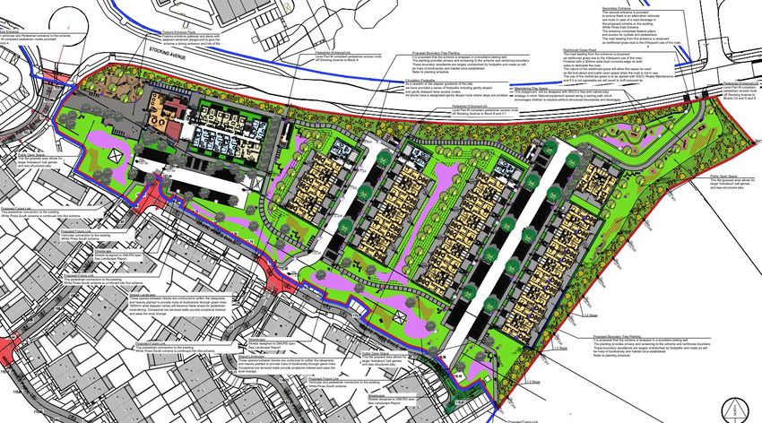
White Pines Central Residential Development
Traffic and Transport Assessment
                                                                                                                             2

Document Control

Job Title:                     White Pines Central Residential Development,
                               Stocking Avenue, Dublin 16

Job Number:                    p190004

Report Ref:                    p190004-rep-008 TTA

Author:                        Daniel Garvey

Reviewed by:                   Mark Kelly

Date:                          May 2021

Distribution:                  Client
                               Design Team
                               DBFL Consulting Engineers

    Revision                 Issue Date                    Description               Prepared          Reviewed          Approved
         -                   16/07/2020                Design Team Review                DG                 MK                   -
         A                   15/09/2020                Design Team Review                DG                 MK                   -
         B                   30/10/2020                Design Team Review                DG                 MK                   -
         C                   06/11/2020              Issued for ABP Pre-App              DG                 MK                   -
         D                   23/04/2021                       Pre-App                    DG                 MK               RJK
       Final                 27/05/2021                       Pre-App                    DG                 MK               RJK

 DBFL Consulting Engineers
 Dublin Office                               Waterford Office                            Cork Office
 Ormond House                                Suite 8b Atrium                             14 South Mall
 Upper Ormond Quay                           Maritana Gate                               Cork
 Dublin 7                                    Canada Street, Waterford                    T12 CT91

 Tel         01 4004000                      Tel        051 309500                       Tel        021 2024538
 Fax         01 4004050                      Email      info@dbfl.ie                     Email      info@dbfl.ie
 Email       info@dbfl.ie                    Web        www.dbfl.ie                      Web        www.dbfl.ie
 Web         www.dbfl.ie

DBFL Consulting Engineers disclaims any responsibility to the Client and others in respect of any matters outside the scope of this
report. This report has been prepared with reasonable skill, care and diligence within the terms of the Contract with the Client
and generally in accordance with ACEI SE 9101 Conditions of Engagement and taking account of the manpower, resources,
investigations and testing devoted to it by agreement with the Client. This report is confidential to the Client and DBFL Consulting
Engineers accepts no responsibility of whatsoever nature to third parties to whom this report or any part thereof is made known.
Any such party relies upon the report at their own risk.

DBFL Consulting Engineers                                                                                           190004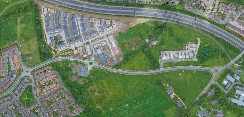
White Pines Central Residential Development
Traffic and Transport Assessment
                                                                                                                                                3

                                                              CONTENTS

1.0 INTRODUCTION .................................................................................. 5
  1.1       BACKGROUND ............................................................................................................. 5
  1.2       SCOPE ......................................................................................................................... 5
  1.3       METHODOLOGY .......................................................................................................... 5
  1.4       REPORT STRUCTURE .................................................................................................. 7

2.0 RECEIVING ENVIRONMENT .............................................................. 8
  2.1       LAND USE .................................................................................................................... 8
  2.2       LOCATION ................................................................................................................... 8
  2.3       LOCAL AMENITIES .................................................................................................... 10
  2.4       EXISTING TRANSPORTATION INFRASTRUCTURE .................................................... 12
  2.5       ROAD SAFETY RECORD............................................................................................. 20
  2.6       EMERGING TRANSPORT DEVELOPMENTS (LAP & NATIONAL POLICY) ................... 21

3.0 POLICY FRAMEWORK....................................................................... 26
  3.1       SMARTER TRAVEL – A SUSTAINABLE TRANSPORT FUTURE .................................... 26
  3.2       SUSTAINABLE URBAN HOUSING: DESIGN STANDARDS FOR NEW APARTMENTS –
  MARCH 2018 ......................................................................................................................... 27
  3.3       DESIGN MANUAL FOR URBAN ROADS AND STREETS (DMURS) - 2019................... 29
  3.4       TRANSPORT STRATEGY FOR THE GREATER DUBLIN AREA 2016-2035 .................. 30
  3.5       SOUTH DUBLIN COUNTY DEVELOPMENT PLAN 2016-2022 ..................................... 31
  3.6       BALLYCULLEN – OLDCOURT LOCAL AREA PLAN 2014 ............................................. 33

4.0 CHARACTERISTICS OF PROPOSALS .............................................. 36
  4.1       OVERVIEW ................................................................................................................ 36
  4.2       VEHICULAR/PEDESTRIAN/CYCLE ACCESS ARRANGEMENTS .................................... 37
  4.3       CYCLE PARKING PROVISION .................................................................................... 39
  4.4       VEHICLE PARKING REQUIREMENT ........................................................................... 42
  4.5       INITIATIVES FOR SUSTAINABLE TRAVEL................................................................. 45
  4.6       PEDESTRIAN CONNECTIVITY ................................................................................... 47

5.0 TRIP GENERATION AND DISTRIBUTION ..................................... 48
  5.1       INTRODUCTION ........................................................................................................ 48
  5.2       TRAFFIC SURVEYS .................................................................................................... 48
  5.3       TRIP GENERATION .................................................................................................... 49
  5.4       COMMITTED DEVELOPMENT .................................................................................... 51
  5.5       TRIP DISTRIBUTION & ASSIGNMENT ...................................................................... 54
  5.6       TRAFFIC GROWTH .................................................................................................... 54

DBFL Consulting Engineers                                                                                                               190004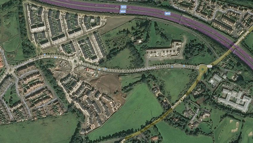
White Pines Central Residential Development
Traffic and Transport Assessment
                                                                                                                                           4

  5.7      ASSESSMENT SCOPE ................................................................................................. 55
  5.8      NETWORK IMPACT .................................................................................................... 56

6.0 MITIGATION MEASURES ................................................................. 59
  6.1      MOBILITY MANAGEMENT PLAN (MMP) ..................................................................... 59
  6.2      CAR PARKING STRATEGY ......................................................................................... 60

7.0 CONSTRUCTION PHASE ................................................................... 61
  7.1      OVERVIEW ................................................................................................................ 61

8.0 SUMMARY AND CONCLUSION ........................................................ 63
  8.1      OVERVIEW ................................................................................................................ 63
  8.2      SUMMARY .................................................................................................................. 64
  8.3      CONCLUSION ............................................................................................................ 65

                                                         APPENDICES

APPENDIX A                      Traffic Flow Diagrams

APPENDIX B                      TRICS Output Data

DBFL Consulting Engineers                                                                                                          190004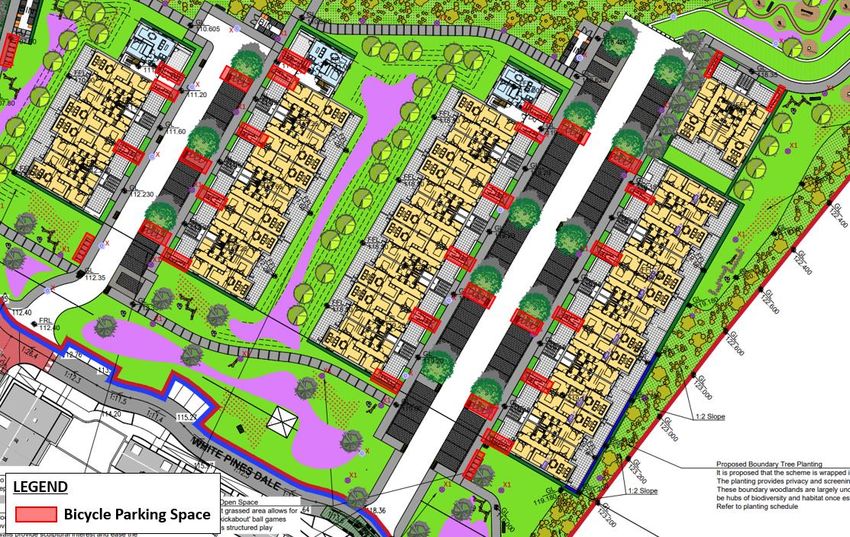
White Pines Central Residential Development
Traffic and Transport Assessment
                                                                                               5

1.0        INTRODUCTION

1.1        BACKGROUND

1.1.1      DBFL Consulting Engineers (DBFL) has been commissioned by Ardstone Homes
           Limited to compile a Traffic and Transport Assessment (TTA) for a proposed
           residential development on a greenfield site located at Stocking Avenue, Dublin 16,
           Co. Dublin.

1.1.2      The proposal is for a residential development of 114 units, located on lands to the
           southeast of the Stocking Avenue / White Pines Way / White Pines South roundabout
           in Woodstown, Dublin, comprising 32 no. 1-bed apartment units, 53 no. 2-bed
           apartment units and 29 no. 3-bed duplex units. The development also comprises 98
           no. car parking spaces and 238 no. cycle parking spaces and will be accessed via
           White Pines South located to the south of the subject development site.

1.1.3      The report has been produced to address any potential concerns that the local
           planning authority may have pertaining to the level of influence of the proposed
           development upon the local transportation system.

1.1.4      During the development of this report, traffic turning count surveys that were
           undertaken at key junctions in the vicinity of the site were used to analyse existing
           traffic movement patterns across the local road network. This information has been
           supplemented with data obtained from site audits of the local road network,
           subsequently enabling the identification of existing local travel characteristics and an
           appreciation of the local receiving environment from a transportation perspective.

1.2        SCOPE

1.2.1      The purpose of this TTA is to quantify the existing transport environment and to detail
           the results of assessment work undertaken to identify the potential level of any
           transport impact generated as a result of the proposed development. The scope of
           the assessment covers transport and related sustainability issues including means of
           vehicular access, pedestrian, cyclist and local public transport connections. The
           principal objective of the report is to quantify any level of impact across the local road
           network and subsequently ascertain both the existing and future operational
           performance of the local road network.

1.3        METHODOLOGY

DBFL Consulting Engineers                                                                190004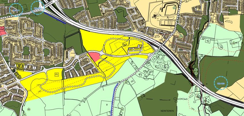
White Pines Central Residential Development
Traffic and Transport Assessment
                                                                                                  6

1.3.1      Our approach to the study accords with policy and guidance both at a national and
           local level. Accordingly, the adopted methodology responds to best practices, current
           and emerging guidance, exemplified by a series of publications, all of which advocate
           this method of analysis. Key publications consulted include;

              •    ‘Traffic and Transport Assessment Guidelines’ (May 2014) National Road
                   Authority;

              •    ‘Traffic Management Guidelines’ Dublin Transportation Office & Department of
                   the Environment and Local Government (May 2003);

              •    ‘Guidelines for Traffic Impact Assessments’ The Institution of Highways and
                   Transportation; and

              •    South Dublin County Council Development Plan 2016-2022.

1.3.2      Our methodology incorporated a number of key inter-related stages, including;

              •    Background Review: This important exercise incorporated three parallel
                   tasks which included (a) an examination of the local regulatory and
                   development management documentation; (b) an analysis of previous
                   ‘transport’ related, strategic and site specific studies of development and
                   transport infrastructure proposals across the Ballycullen area and (c) a review
                   of planning applications to establish the legal status of various third party
                   development schemes that were either considered within the strategic
                   ‘transport’ studies or which have emerged and received full planning permission
                   since.

              •    Site Audit: A site audit was undertaken to quantify existing road network
                   issues and identify local infrastructure characteristics, in addition to establishing
                   the level of accessibility to the site in terms of walking, cycling and public
                   transport. An inventory of the local road network was also developed during
                   this stage of the assessment.

              •    Traffic Counts: Traffic counts surveys were analysed with the objective of
                   establishing local traffic characteristics in the immediate area of the proposed
                   development.

DBFL Consulting Engineers                                                                   190004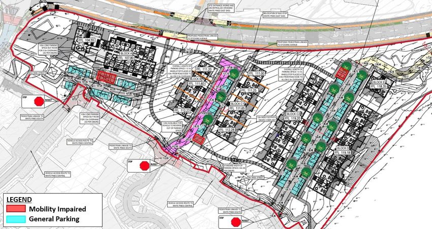
White Pines Central Residential Development
Traffic and Transport Assessment
                                                                                              7

              •    Trip Generation: A trip generation exercise has been carried out to establish
                   the potential level of vehicle trips generated by the proposed development.

              •    Trip Distribution: Based upon both the existing and future network
                   characteristics, a distribution exercise has been undertaken to assign site
                   generated vehicle trips across the local road network.

              •    Network Analysis: Further to quantifying the predicted impact of vehicle
                   movements across the local road network for the adopted site access strategy
                   more detailed computer simulations have been undertaken to assess the
                   operational performance of key junctions in the post development 2023, 2028
                   and 2038 development scenarios.

1.4        REPORT STRUCTURE

1.4.1      As introduced above, this TTA seeks to clarify the potential level of influence
           generated by the proposed development upon the local road network and
           subsequently ascertain the existing and future operational performance of the local
           transport system. The structure of the report responds to the various stages of this
           exercise including the key tasks summarised below.

1.4.2      Chapter 2 of this report describes the existing conditions at the proposed
           development location and surrounding area, whilst Chapter 3 provides a summary
           of the relevant transport policies that influence the design and appraisal of the subject
           residential proposal.

1.4.3      A description of the proposed development scheme is described in Chapter 4 whilst
           Chapter 5 outlines the trip generation exercise carried out and the adopted
           methodology for applying growth factors to establish design year network traffic flows
           and the predicted scale of impact upon the local road network.

1.4.4      A number of mitigation measures are summarised within Chapter 6 whilst Chapter
           7 outlines how the construction phase of the project will be managed.

1.4.5      The main conclusions and recommendations derived from the analysis are
           summarised in Chapter 8.

DBFL Consulting Engineers                                                               190004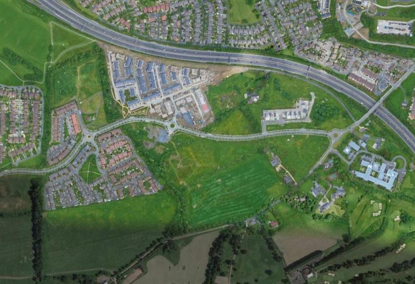
White Pines Central Residential Development
Traffic and Transport Assessment
8
2.0 RECEIVING ENVIRONMENT
2.1 LAND USE
2.1.1 The subject site is located on a greenfield area within the Woodtown suburb of South
Dublin. The site lies within the Ballycullen-Oldcourt Local Area Plan (LAP) lands. The
subject site predominantly comprises greenfield site and is zoned as Objective RES-N
which aims “To provide for new residential communities in accordance with approved
area plans” within the 2016-2022 South Dublin County Development Plan as shown
in Figure 2.1.
N
Subject Site
Figure 2.1: South Dublin County Council Zoning Objectives
2.2 LOCATION
2.2.1 The subject site is located approximately 11km south-west of Dublin City Centre, 5km
south-east from Tallaght Town Centre and offers good access to the M50 Motorway,
via Junction 12, located to the north-west of the site.
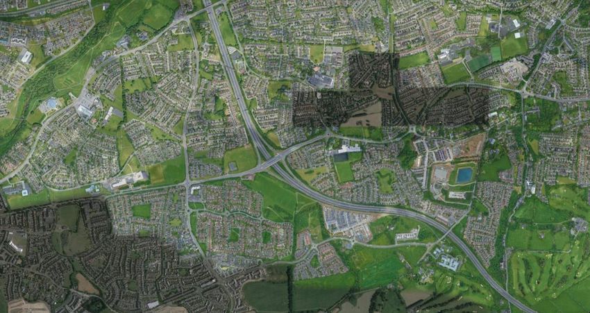
2.2.2 The general location of the subject site in relation to the surrounding road network is
illustrated in below in Figure 2.2, while Figure 2.3 indicatively shows the extent of
the subject site boundary and neighbouring lands.
DBFL Consulting Engineers 190004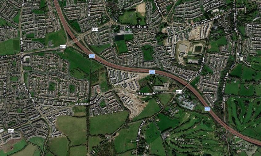
White Pines Central Residential Development
Traffic and Transport Assessment
                                                                                                  9

       N

                                                                             Subject Site

                                    Figure 2.2: Site Location (Source: www.google.ie/maps)

   N

                                          Indicative Site Boundary

                       Figure 2.3: Indicative Site Boundary (Source: www.google.ie/maps)

2.2.3      The subject site is bound to the north by Stocking Avenue and to the west by the
           residential development of White Pines South. The site is situated in close proximity
           to the established residential area of Stocking Wood and Stocking Well to the west as
           well as Woodstown Village, Knocklyon which is approximately 1.8km north-west of
           the development site.

DBFL Consulting Engineers                                                                    190004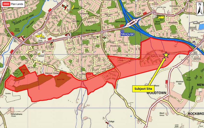
White Pines Central Residential Development
Traffic and Transport Assessment
                                                                                                10

2.3        LOCAL AMENITIES

2.3.1      The proposed development site is well placed in terms of proximity to local amenities
           including schools such as Edmondstown National School, Rockbrook Park School, St
           Colmcille's Community School, Sancta Maria College, Ballyroan Boys National School,
           Scoil Naomh Padraig, Colaiste Eanna C.B.S, Firhouse Educate Together National
           School, South Dublin Music School, Firhouse Community College and Holy Rosary
           Primary School.           Additionally, the site is also conveniently situated close to
           Woodstown Shopping Centre and LIDL approximately 1.8km to the north-west.

2.3.2      In terms of leisure facilities, the subject site is approximately 950m and 2.3km to the
           east of Rathfarnham and Edmondstown Golf Clubs respectively, while Firhouse
           Community & Leisure Club is situated approximately 2.5km west of the development
           site. There are a number of health care facilities in close proximity to the site, including
           medical clinics in Woodtown village centre and Ballycullen west of the development,
           while the Bloomfield Health Service is located in the vicinity of the development to
           the east. Figure 2.4 below show indicatively the subject site’s location in relation to
           the aforementioned local amenities. There is a proposed retail unit, White Pines Retail,
           that is currently under construction and when completed will be situated
           approximately 100m west of the development site.

                                                                                           N

                                              Subject Site

                                   Figure 2.4: Subject Site Area Local Amenities

DBFL Consulting Engineers                                                                  190004
White Pines Central Residential Development
Traffic and Transport Assessment
11
N
Sancta Maria College Ballyroan B.N.S
20 mins – Walk 27 mins – Walk
7 mins - Cycle 7 mins - Cycle
St Colmcille's
Community School
27 mins – Walk
8 mins - Cycle
SPAR
23 mins – Walk
6 mins - Cycle
LIDL
22 mins – Walk
6 mins - Cycle
Figure 2.5: Subject Site Area Local Amenities
DBFL Consulting Engineers 190004White Pines Central Residential Development
Traffic and Transport Assessment
12
2.4 EXISTING TRANSPORTATION INFRASTRUCTURE
Road Network
2.4.1 Stocking Avenue runs in an east-west direction along the northern site boundary,
comprising a two-way single lane carriageway with 3.75m wide traffic lanes in both
directions in the vicinity of the site. Stocking Avenue is subject to a speed limit of
50kph with street lighting provided on both sides and traffic calming features in the
form of road humps located at intervals along the carriageway.
2.4.2 Stocking Avenue connects to a four-arm roundabout junction with Stocking Lane
(R115) approximately 300m to the east to the development site.
2.4.3 Approximately 1.2km to the west of the subject site, Stocking Avenue connects to a
roundabout junction with Hunters Road and Ballycullen Road, which provides onward
connections to the M50 Motorway Junction 12 north-west of the site. The M50
Motorway provides strategic network access across the Greater Dublin Area and
onward links to the M1 Motorway Northbound and the M11 Motorway Southbound,
via Blanchardstown and Sandyford.
2.4.4 Stocking Lane (R115) extends from Stocking Avenue junction in both northern and
southern directions, towards the city centre of Dublin (via Ballyboden) and the Dublin
Mountains, respectively.
2.4.5 Ballycullen Road extends from the roundabout with Stocking Avenue north towards
Firhouse Road (R114). It intersects Killinniny Road (R113) and St. Colmcille’s Way at
a 4-arm signalized junction. Eastbound along St. Colmcille’s Way provides access to
the M50 via Junction 12, while westbound via Killinniny Road provides access to
Tallaght and south west Dublin.
2.4.6 Figure 2.6 below illustrates the location of the subject site within the context of the
existing road network.
DBFL Consulting Engineers 190004White Pines Central Residential Development
Traffic and Transport Assessment
13
Figure 2.6: Existing Road Network (Source: www.google.ie/maps)
Existing Pedestrian and Cycling Facilities
2.4.7 A segregated cycle track and footpath is provided on both sides of Stocking Avenue
between the development site and the Stocking Lane/Stocking Avenue junction to the
east. Similarly, to the west of the development site a segregated cycle track and
footpath are provided on both sides of Stocking Avenue, up to the junction with
Ballycullen Road and Hunters Road, as shown in Figure 2.7 and Figure 2.8 below.
Pedestrian & Cyclist
Facilities
Figure 2.7: Pedestrian/Cycle Facilities on Stocking Avenue Looking West
DBFL Consulting Engineers 190004White Pines Central Residential Development
Traffic and Transport Assessment
14
Pedestrian & Cyclist
Facilities
Figure 2.8: Stocking Avenue Looking East
2.4.8 In addition to the aforementioned cycle facilities on Stocking Avenue, a segregated
southbound cycle tracks is provided on Ballycullen Road, as shown in Figure 2.9,
while northbound cyclists are required to use the northbound bus lane.
Segregated Southbound
Pedestrian & Cyclist Facility
Bus Lane for
Northbound Cyclists
Figure 2.9: Cycling Facilities on Ballycullen Road
2.4.9 The Stocking Avenue/White Pines Way/White Pines South Roundabout was upgraded
as part of the planning application SD14A/0222, to better reflect DMURS guidelines,
providing a safer environment for pedestrians and cyclists while also reducing traffic
speeds (i.e. the shared pedestrian/cycle crossings were widened, while the
carriageway widths and circulating width around the roundabout were reduced).
DBFL Consulting Engineers 190004White Pines Central Residential Development
Traffic and Transport Assessment
15
2.4.10 Furthermore, there are a variety of cycle facilities available on the surrounding
network as illustrated below in Figure 2.10 which illustrates the National Transport
Authorities’ (NTA) Greater Dublin Area Existing Cycle Facilities (2013).
Subject Site
N
Figure 2.10: Existing Cycle Facilities (Extract of Sheet E6 GDA Cycle Network Plan)
Site Accessibility - Walking
2.4.11 Existing walking time isochrones from the development site are shown in Figure
2.11, which illustrates the high levels of accessibility for pedestrians walking to/from
the site. The walking time isochrones illustrates that food supermarkets and St
Colmcille's Community School are within a 30 minute walking distance, and Sancta
Maria College, Ballyroan Boys National School, Scoil Naomh Padraig and Colaiste
Eanna C.B.S are within a 45 minute walking distance.
DBFL Consulting Engineers 190004White Pines Central Residential Development
Traffic and Transport Assessment
16
Figure 2.11: Walking Isochrones from the Subject Development Site (Source:
Traveltime.com)
Site Accessibility - Cycling
2.4.12 The cycling time isochrones from the development site were created and are shown
in Figure 2.12 below, which illustrates that Tallaght is within a 15 minute cycling
distance from the subject site, whereas, Rathfarnham, Dundrum, Saggart are within
a 30 minute cycling distance and Brittas, Clondalkin, Sandyford, Blackrock and
Dublin City Centre are within a 45 minute cycling distance from the proposed
development site entrance.
DBFL Consulting Engineers 190004White Pines Central Residential Development
Traffic and Transport Assessment
17
Figure 2.12: Cycling Isochrones from the Subject Development Site (Source: Traveltime.com)
Site Accessibility – Public Transport & Walking
2.4.13 Regarding public transport accessibility, the subject site currently benefits from bus
services in close proximity to the site as outlined in the provious section. In order to
obtain reaslistic journey times, the following maps give travel times during AM peak
time hours, in this case 8.00am on a Tuesday. The public transport time isochrones
from the development site were created and are shown in Figure 2.13 below, which
illustrates that Tallaght, Rathfarnham, Rathmines and Portobello are within a 30
minute public transport distance and Crumlin, Dundrum and Dublin City Centre are
within a 45 minute public transport distance from the proposed development site
entrance.
DBFL Consulting Engineers 190004White Pines Central Residential Development
Traffic and Transport Assessment
18
Figure 2.13: Public Transport Isochrones from the Subject Development Site (Source:
Traveltime.com)
Public Transport – Bus
2.4.14 Dublin Bus Route 15b travels along Stocking Avenue with bus stops located to the
north boundary of the site along Stocking Avenue (approx. 1min walking). Dublin Bus
Route 15 travels along Ballycullen Road with bus stop facilities available approximately
1.2km to the west of the subject site. Dublin Bus Route 65b travels along Ballycullen
Road with bus stop facilities available approximately 2.0km to the northwest of the
subject site. Go Ahead Bus Route 161 travels along Edmondstown Road with bus stop
facilities available approximately 1.2km to the east of the subject site. Go Ahead Bus
Route 175 travels along Scholarstown Road with bus stop facilities available
approximately 1.8km to the northwest of the subject site. Figure 2.14 below
provides details of the above bus routes and the closest bus stop opportunities
available to the subject development site.
DBFL Consulting Engineers 190004White Pines Central Residential Development
Traffic and Transport Assessment
19
Walking distance
from bus stop: 2.0km
Approx. 26 min
N
Walking distance
from bus stop: 50m
Approx. 1 min
Walking distance
from bus stop: 1.8km
Approx. 23 min
Walking distance
from bus stop: 1.2km
Approx. 15 min
Walking distance
Indicative Site
from bus stop: 1.2km Boundary
Approx. 15 min
Figure 2.14: Existing Dublin Bus Routes and walking distance from Bus Stops
(Source: www.google.ie/maps)
2.4.15 All of the routes operate daily as summarised in Table 2.1. Route 15b, which travels
along Stocking Avenue directly passing the subject development site provides
convenient connections to and from Rathfarnham, Rathgar, City Centre and Grand
Canal Dock. Additional areas can be accessed via the number 15 route with
connections to/from Knocklyon, Templeogue, Rathgar, City Centre, Fairview, Coolock
and Clongriffin available. Route 65b offers connections to/from the City Centre,
Rathmines, Terenure, Templeogue, Old Bawn and Citywest. Route 161 offers
connections to/from Dundrum, Nutgrove, Ballyboden and Rockbrook. Route 175
offers connections to/from Citywest, Old Bawn, Marley Park, Dundrum and UCD.
Route Monday –
Route Saturday Sunday
Number Friday
15 Clongriffin - Ballycullen Rd 8 - 12 15 15
15b Grand Canal Dock (Benson St.) - Stocking Ave 15 15 20 - 30
65b Poolbeg St. - Citywest 60 60 60
8 Times
161 Dundrum - Rockbrook - -
Daily
175 Kingswood Ave. - UCD 20 -30 40 - 60 60
Table 2.1: Dublin Bus Service Average Frequency (In minutes)
DBFL Consulting Engineers 190004White Pines Central Residential Development
Traffic and Transport Assessment
20
2.5 ROAD SAFETY RECORD
2.5.1 With the objective of ascertaining the road safety record of the immediate routes
leading to/from the subject site, the collision statistics as detailed on the Road Safety
Authority’s (RSA) website (www.rsa.ie) have been examined. The RSA website
includes basic information relating to reported collisions over the most recent twelve-
year period, from 2005 to 2016 inclusive.
2.5.2 The RSA database records detail where collision events has been officially recorded
such as when the Garda being present to formally record details of the incident.
2.5.3 Table 2.2 below summarises the RSA Collision Data in the vicinity of the proposed
development.
2.5.4 The review of the RSA data reveals that the local road network exhibits a good safety
record considering the volume of traffic traveling across the local road network as
only one minor incident has been recorded in the vicinity of the subject site.
N
Subject Site
1
Figure 2.15: Collision Records - (Source: www.rsa.ie)
2.5.5 In summary the review confirms that no significant incident trends or significant
safety concerns are evident across the local road network.
Severity Year Vehicle Circumstances Day Time Casualty
Ref
Single vehicle Sun 1900-2300 1
1 Minor 2008 Car
only
Table 2.2: Collision Records - (Source: www.rsa.ie)
DBFL Consulting Engineers 190004White Pines Central Residential Development
Traffic and Transport Assessment
21
2.6 EMERGING TRANSPORT DEVELOPMENTS (LAP & NATIONAL POLICY)
Ballycullen-Oldcourt Local Area Plan Transport Initiatives
2.6.1 The Ballycullen-Oldcourt LAP (2014) includes proposals for the provision of road
infrastructure upgrades along with upgraded/new pedestrian and cycle facilities within
the LAP area as shown in Figure 2.16 and summarised as follows:
• Roundabouts along Stocking Avenue to be upgraded to signal controlled
junctions;
• The construction of the “Oldcourt Main Link Street” which will serve the subject
development and future developments within the Oldcourt Lands. It will connect
Bohernabreena Road to the west with Oldcourt Road to the east;
• Pedestrian/Cycle Connections linking the subject site with the neighbouring
residential areas to the west; and
• Pedestrian Crossing facilities at various locations along Stocking Avenue.
2.6.2 It is noted that the Stocking Avenue roundabout, located to the southwest of the site
is indicated in the LAP to be removed or signalised. However, this roundabout was
upgraded as part of the planning application SD14A/0222, to better reflect DMURS
guidelines, providing a safer environment for pedestrians and cyclists while also
reducing traffic speeds. Based on discussions with SDCC Roads Department
throughout the pre-planning stages, it is understood that the roundabout would not
be removed/signalised in the near future.
DBFL Consulting Engineers 190004White Pines Central Residential Development
Traffic and Transport Assessment
22
Figure 2.16: Infrastructure Proposals (Extract from Ballycullen – Oldcourt LAP)
DBFL Consulting Engineers 190004White Pines Central Residential Development
Traffic and Transport Assessment
23
GDA Cycle Network Plan (2013)
2.6.3 The subject site is located within the “Dublin South West Sector” as outlined within
the Greater Dublin Area Cycle Network Plan (2013). The Sector “extends outward
from the twin corridors of Camden Street and Clanbrassil Street in the city centre,
through the inner suburbs of Rathmines and Harold’s Cross, to serve the areas of
Terenure, Kimmage, Walkinstown, Tallaght, Firhouse and Rathfarnham.”
2.6.4 There is a feeder route proposed along Stocking Avenue which will provide a
connection to Secondary Route SO6 to the west and Secondary Route 10 to the east.
2.6.5 As mentioned in Chapter 2.4, there are currently segregated cycle tracks on both
sides of Stocking Avenue from Stocking Lane junction to Dodderbrook.
2.6.6 According to the GDA, the proposals include upgrades to the Orbital Cycle Route SO6
between Scholarstown and Old Bawn via the Ballycullen area and upgrades to the
Radial Cycle Route 10 along from Portobello Bridge on the Grand Canal along
Rathmines Road and Rathgar Road to Terenure Cross.
2.6.7 In the vicinity of the subject site, the Plan proposes the following route additions as
indicated on Figure 2.17 below:
N
Figure 2.17: Proposed Cycle Routes
(Extract of Sheet N6 GDA Cycle Network Plan 2013)
DBFL Consulting Engineers 190004White Pines Central Residential Development
Traffic and Transport Assessment
24
BusConnects
2.6.8 The National Transport Authority (NTA) has developed a strategic transport plan,
known as BusConnects, which will transform and overhaul the current bus network
to provide a more efficient network. The proposed network will deliver the ‘next
generation’ of bus corridors on the busiest routes and redesign routes with the aim
of offering fast, predictable and reliable bus journeys.
2.6.9 Under the BusConnects proposals, the following routes will serve Ballycullen and the
subject site and are shown below in Figure 2.18:
• A1 Route – Ballycullen - Beaumont
• 85 Route – Tallaght – Parnell Square
2.6.10 The number 85 bus route, proposed under BusConnects, runs from Tallaght to the
City Centre via Ballyboden, Rathfarnham, Harold’s Cross and on to Parnell Square.
This route is proposed to operate with a frequency of 10-15 minutes along Stocking
Avenue and is directly adjacent the subject development site (approx. 1 min walk).
This new bus route provides the subject development site with direct access to
Tallaght, a proposed transport hub/key interchange between several radial and
orbital services, along with the LUAS Red Line which offers an alternative means
of travelling to the city centre.
2.6.11 The A1 bus route runs from Ballycullen to Beaumont via City Centre. This route is
proposed to run along Ballycullen Road, approximately 1.2km west of the subject
development, with services proposed to operate with a 10-15 minute frequency.
DBFL Consulting Engineers 190004White Pines Central Residential Development
Traffic and Transport Assessment
25
Subject Site
Figure 2.18: Proposed Public Transport Routes (Source: www.busconnects.ie)
DBFL Consulting Engineers 190004White Pines Central Residential Development
Traffic and Transport Assessment
26
3.0 POLICY FRAMEWORK
3.1 SMARTER TRAVEL – A SUSTAINABLE TRANSPORT FUTURE
3.1.1 Smarter Travel was published in 2009 by the Department of
Transport which represents the national policy documentation
outlining a broad vision for the future and establishes
objectives and targets for transport. The document examines
past trends in population and economic growth and transport
concluding that these trends are unsustainable into the
future.
3.1.2 In order to address the unsustainable nature of current travel
behaviour, Smarter Travel sets down a number of key goals
and targets for 2020 - including:
• Total vehicle km travelled by car will not significantly increase;
• Work-related commuting by car will be reduced from 65% to 45%;
• 10% of all trips will be by cycling; and
• The efficiency of the transport system will be significantly improved.
3.1.3 The document recognises that these are ambitious targets, and outlines a suite of 49
actions required to achieve these targets – summarised under the following four main
headings:
• Actions aimed at reducing distances travelled by car and the use of fiscal
measures to discourage use of the car;
• Actions aimed at ensuring that alternatives to the car are more widely available;
• Actions aimed at improving fuel efficiency of motorized travel; and
• Actions aimed at strengthening institutional arrangements to deliver the targets.
DBFL Consulting Engineers 190004White Pines Central Residential Development
Traffic and Transport Assessment
27
3.2 SUSTAINABLE URBAN HOUSING: DESIGN STANDARDS FOR NEW
APARTMENTS – DECEMBER 2020
3.2.1 This guideline document was produced by the Department
of Housing, Planning and Local Government and was
updated with the latest version in December 2020. The
purpose of this document is to set out standards for
apartment development, mainly in response to
circumstances that had arisen whereby some local authority
standards were at odds with national guidance.
3.2.2 With the demand for housing increasing, this means that
there is a need for an absolute minimum of 275,000 new
homes in Ireland’s cities by 2040. It is therefore critical to ensure that apartment living
is an increasingly attractive and desirable housing option for a range of household types
and tenures.
3.2.3 These Guidelines apply to all housing developments that include apartments that may
be made available for sale, whether for owner occupation or for individual lease. They
also apply to housing developments that include apartments that are built specifically
for rental purposes, whether as ‘build to rent’ or as ‘shared accommodation’.
3.2.4 Cycling provides a flexible, efficient and attractive transport option for urban living and
these guidelines require that this transport mode is fully integrated into the design and
operation of all new apartment development schemes.
3.2.5 The quantum of car parking or the requirement for any such provision for apartment
developments will vary, having regard to the types of location in cities and towns that
may be suitable for apartment development, broadly based on proximity and
accessibility criteria. There are three types of locations set out that will determine the
level of parking provided. The Central and/or Accessible Urban Locations
comprise of apartments in more central locations that are well served by public
transport. These locations have a default policy for car parking provision to be
minimised, substantially reduced or wholly eliminated in certain circumstances. The
Intermediate Urban Locations comprise of apartments in suburban/urban locations
served by public transport or close to town centres or employments areas. These
locations require that planning authorities must consider a reduced overall car parking
standard and apply an appropriate maximum cap parking standard. The Peripheral
and/or Less Accessible Urban Locations comprise of apartments located in
DBFL Consulting Engineers 190004White Pines Central Residential Development
Traffic and Transport Assessment
28
relatively peripheral or less accessible urban locations, one car parking space per unit,
together with an element of visitor parking should generally be required.
3.2.6 It is considered that the subject development site is located within an “Intermediate
Urban Location” as designated within the DHPLG standards, on the basis of the
proximity to high frequency urban public transport stops.
3.2.7 The subject site is within walking distance (i.e. between 5-10 minutes or up to 1,000m)
to/from a high frequency (i.e. min 10 minute peak hour frequency) urban bus service
(15B bus route); and within easy walking distance (i.e. up to 5 minutes or 400-500m)
to/from reasonably frequency (i.e. min 15 minute peak hour frequency) urban bus
service, 15B stop is adjacent to the site.
3.2.8 For all types of location, where it is sought to eliminate or reduce car parking provision,
it is necessary to ensure, where possible, the provision of an appropriate number of
drop off, service, visitor parking spaces and parking for the mobility impaired. Provision
is also to be made for alternative mobility solutions including facilities for car sharing
club vehicles and cycle parking and secure storage.
DBFL Consulting Engineers 190004White Pines Central Residential Development
Traffic and Transport Assessment
29
3.3 DESIGN MANUAL FOR URBAN ROADS AND STREETS (DMURS) - 2019
3.3.1 DMURS provides guidance relating to the design of urban roads and
streets. It presents a series of principles, approaches and standards
that are necessary to achieve balanced, best practice design
outcomes with regard to street networks and individual streets.
3.3.2 The manual places a significant emphasis on car dominance in
Ireland and the implications this has had regarding the pedestrian
and cycle environment. The document encourages more
sustainable travel patterns and safer streets by proposing a
hierarchy for user priorities. This hierarchy places pedestrians at the top, indicating that
walking is the most sustainable form of transport and that by prioritizing pedestrians
first, the number of short car journeys can be reduced and public transport made more
accessible.
3.3.3 Second in the hierarchy are cyclists with public transport third in the hierarchy and
private motor vehicles at the bottom. By placing private vehicles at the bottom of the
hierarchy, the document indicates that there should be a balance on street networks
and cars should no longer take priority over the needs of other users.
3.3.4 The manual emphasizes that narrow carriageways are one of the most effective design
measures that calm traffic. Standard width of an arterial and link street is 3.25m,
however, this may be reduced to 3m where lower design speeds are being applied.
Desirable footpath widths are between 2m – 4m. The 2m width should be implemented
to allow for low to moderate pedestrian activity. A 3m – 4m footpath should be
implemented to allow for moderate to high pedestrian activity.
3.3.5 The focus of the manual is to create a place – based sustainable street network that
balances the pedestrian and vehicle movements. The manual references the different
types of street networks, including arterial streets, link streets, local streets, and
highlights the importance of movement.
DBFL Consulting Engineers 190004White Pines Central Residential Development
Traffic and Transport Assessment
30
3.4 TRANSPORT STRATEGY FOR THE GREATER DUBLIN AREA 2016-2035
3.4.1 The Transport Strategy for the Greater Dublin Area 2016-
2035 is a document compiled by the National Transport
Authority which sets out the Strategic Transport Plan for the
Greater Dublin Area for the period up to 2035. This sets out
an integrated long-term strategy for the area and includes
new public transport proposals such as DART and Luas
expansion, BusConnects and also a new Metro route.
3.4.2 This document will influence transport planning across the
region until 2035 and replaces ‘A Platform for Change – An
Integrated Transportation Strategy for the Greater Dublin Area 2000 to 2016’. It
thereby underpins all transportation strategies, traffic management schemes and
development plans prepared by South Dublin County Council during this timeframe.
3.4.3 The Strategy sets out a clear hierarchy of transport users, commencing with the
sustainable modes of travel such as walking, cycling and public transport users at the
very top of the hierarchy. The Strategy adopts the general principle that these users
should have their safety and convenience needs considered first and that the hierarchy
is applied where a large share of travel is (or could be) made by walking, cycling and
public transport.
3.4.4 In addition to guiding the development of specific Strategy measures, the NTA
encourages that the “transport user hierarchy should guide engineers, planners and
urban designers on the order in which the needs of transport users should be
considered in designing new developments or traffic schemes in the Greater Dublin
Area.”
DBFL Consulting Engineers 190004White Pines Central Residential Development
Traffic and Transport Assessment
31
3.5 SOUTH DUBLIN COUNTY DEVELOPMENT PLAN 2016-2022
3.5.1 The South Dublin County Development Plan 2016-2022 sets the broad development
framework for the county and the development areas within its administrative
boundary. In the context of the subject proposals, the following are the relevant
transport and development policies and objectives set out in the plan: -
Transport & Mobility Policies
“Policy 1 – Overarching: It is the policy of the Council to promote the sustainable
development of the County through the creation of an integrated transport network
that services the needs of communities and businesses.”
“Policy 2 – Public Transport: It is the policy of the Council to promote the
sustainable development of the County by supporting and guiding national agencies
in delivering major improvements to the public transport network and to ensure
existing and planned public transport services provide an attractive and convenient
alternative to the car.”
“Policy 3 – Walking and Cycling: It is the policy of the Council to re-balance
movement priorities towards more sustainable modes of transportation by prioritising
the development of walking and cycling facilities within a safe and traffic calmed street
environment.”
“Policy 4 – Strategic Road and Street Network: It is the policy of the Council to
improve and expand the County-wide strategic road and street network to support
economic development and provide access to new communities and development.”
Transport & Mobility Objectives
3.5.2 It is the policy of the Council to promote the sustainable development of the County
through the creation of an integrated transport network and re-balance movement
priorities toward sustainable modes of transportation, as set out in the following
relevant objectives:
“TM1 Objective 3: To focus on improvements to the local road and street network
that will better utilise existing road space and encourage a transition towards more
sustainable modes of transport, while also ensuring sufficient road capacity exists for
the residual proportion of the trips which will continue to be taken by private vehicle.”
DBFL Consulting Engineers 190004White Pines Central Residential Development
Traffic and Transport Assessment
32
“TM1 Objective 4: To prioritise new road construction that provides access to new
communities and development areas and supports the economic development of the
County.”
“TM3 Objective 2: To ensure that connectivity for pedestrians and cyclists is
maximised in new communities and improved within existing areas in order to
maximise access to local shops, schools, public transport services and other
amenities, while seeking to minimise opportunities for anti-social behaviour and
respecting the wishes of local communities.”
Road and Street Proposals
3.5.3 South Dublin County Council (SDCC) is responsible for the management of the regional
and local network within the county. SDCC lists proposals for the short and medium to
long term development of the regional road network. The following are relevant
schemes mentioned under SDCCs Six Year Road Programme to the subject scheme in
the Oldcourt - Ballycullen Lands (Table 3.1):
Location Description Function
Ballycullen-Oldcourt Street Various streets within the Ballycullen- Formation of a strategic street network
Network Oldcourt LAP lands. providing access throughout the site.
Ballyboden Road/ Upgrade of existing road. To enhance pedestrian and cycling
Stocking Lane (R115) facilities and exploit the tourist potential
of the route.
Killinniny Road Minor widening of the existing To reduce delays to the M50 and
carriageway within the curtilage create additional road space for the
of the existing road. provision of dedicated bus and cycle
lanes.
Table 3.1: South Dublin County Council’s Six Year Road Programme
DBFL Consulting Engineers 190004White Pines Central Residential Development
Traffic and Transport Assessment
33
3.6 BALLYCULLEN – OLDCOURT LOCAL AREA PLAN 2014
3.6.1 The subject site lies within the Ballycullen - Oldcourt Local Area Plan lands (Figure
3.1) and as such is governed by the specific policies and objectives outlined with the
Ballycullen - Oldcourt Local Area Plan (2014).
Figure 3.1: LAP Boundary (Extract of Fig 1.1 Ballycullen – Oldcourt LAP)
Accessibility and Movement
3.6.2 The Accessibility and Movement Strategy outlined within the LAP seeks to “open up
the Plan Lands with a clear hierarchy of integrated streets for universal movement
including pedestrian, vehicular and cyclist activity and sets out a framework for such.
This will comprise the upgrade of Stocking Avenue, Hunters Road and Oldcourt Road
as a primary (Main Link) street for movement across the Plan Lands and to areas
outside the Plan Lands.” The LAP also states that planning permission was granted
for “approximately 1,800 dwellings on the eastern side of the Plan Lands between
2000 and 2012” as indicated in Figure 3.2.
DBFL Consulting Engineers 190004White Pines Central Residential Development
Traffic and Transport Assessment
34
Figure 3.2: Development Status (Extract of Fig 1.1 Ballycullen – Oldcourt LAP)
Public Transport
3.6.3 With regards to public transport, the LAP states that “Access to upgraded Main Link
Streets (Stocking Avenue, Hunters Road, Oldcourt Road, and the new Main Link
Street) will be prioritised in the form of direct pedestrian and cycle routes to help
sustain and improve the relatively frequent public transport services on the eastern
side of the Plan Lands and improve the viability of such services on the western side.
This includes for the planned provision of bus lay-bys on the eastern and western
sides of the Plan Lands.”
Ballycullen-Oldcourt Local Area Plan Transport Initiatives
3.6.4 The Ballycullen-Oldcourt LAP (2014) includes proposals for the provision of road
infrastructure upgrades along with upgraded/new pedestrian and cycle facilities within
the LAP area as shown in Figure 2.16 and summarised as follows:
• Roundabouts along Stocking Avenue to be upgraded to signal controlled
junctions;
• The construction of the “Oldcourt Main Link Street” which will serve the subject
development and future developments within the Oldcourt Lands. It will connect
Bohernabreena Road to the west with Oldcourt Road to the east;
• Pedestrian/Cycle Connections linking the subject site with the neighbouring
residential areas to the west; and
• Pedestrian Crossing facilities at various locations along Stocking Avenue.
DBFL Consulting Engineers 190004White Pines Central Residential Development
Traffic and Transport Assessment
35
3.6.5 It is noted that the Stocking Avenue roundabout, located to the southwest of the site
is indicated in the LAP to be removed or signalised. However, this roundabout was
upgraded as part of the planning application SD14A/0222, to better reflect DMURS
guidelines, providing a safer environment for pedestrians and cyclists while also
reducing traffic speeds. Based on discussions with SDCC Roads Department
throughout the pre-planning stages, it is understood that the roundabout would not
be removed/signalised in the near future.
Figure 3.3: Infrastructure Proposals (Extract from Ballycullen – Oldcourt LAP)
DBFL Consulting Engineers 190004White Pines Central Residential Development
Traffic and Transport Assessment
36
4.0 CHARACTERISTICS OF PROPOSALS
4.1 OVERVIEW
4.1.1 The proposal is for a residential development of 114 units, located on lands to the
southeast of the Stocking Avenue / White Pines Way / White Pines South roundabout
in Woodstown, Dublin, comprising 32 no. 1-bed apartment units, 53 no. 2-bed
apartment units and 29 no. 3-bed duplex units. The development also comprises 98
no. car parking spaces and 238 no. cycle parking spaces and will be accessed via
White Pines South located to the south of the subject development site.
4.1.2 Further details of the development proposals including the site layout and internal
transport network arrangements are illustrated in the scheme drawings as submitted
with this planning application. Figure 4.1 below illustrates the plan layout of the
proposed residential development.
N
Figure 4.1: Proposed Development Layout
DBFL Consulting Engineers 190004White Pines Central Residential Development
Traffic and Transport Assessment
37
4.2 VEHICULAR/PEDESTRIAN/CYCLE ACCESS ARRANGEMENTS
4.2.1 The main vehicular access to/from the subject development will be provided via White
Pines South on the southern boundary of the site which connects onto a roundabout
on Stocking Avenue, as shown in Figure 4.2 below. There will also be an emergency
vehicular access onto Stocking Avenue via a new priority junction on the north-eastern
boundary of the site. This is proposed for emergency vehicles only and will be
controlled with bollards to prohibit general vehicles using the access. However,
pedestrians and cyclists will be able to use this emergency access on a regular basis.
Emergency
Site Access
N
Pedestrian
Access
Vehicular
Site Access
Figure 4.2: Proposed Site Access Locations
4.2.2 These vehicular accesses will also be accessible to both pedestrian and cyclists. There
are additional pedestrian access points located to the north, providing access to
Stocking Avenue and to the South providing access to White Pines South as shown in
Figure 4.2. These non-vehicular access points provide filtered permeability, ensuring
shorter walking and cycling distances and increasing the attractiveness of these
sustainable modes.
4.2.3 The internal street layout has been designed to respect the principles and guidance
outlined within the Design Manual for Urban Roads and Streets (DMURS). The design
of the internal streets will seek to provide self-regulating streets whilst respecting the
important functions of both place and movement in a consistent and integrated
contextual manner. Self-regulating streets aim to balance the functional needs of
DBFL Consulting Engineers 190004White Pines Central Residential Development
Traffic and Transport Assessment
38
different users (vehicles, pedestrians and cyclists), enhance the sense of place and
manage speed in a manner that does not rely on extensive regulatory controls and
physical intrusive measures for enforcement.
4.2.4 Speeds within the development will be minimised through the inclusion of a number
of vertical and horizontal control measures including;
• Tight corner radii;
• Table-top ramps.
• Narrow streets (generally 5.5m); and
• Short lengths of straight streets.
DBFL Consulting Engineers 190004White Pines Central Residential Development
Traffic and Transport Assessment
39
4.3 CYCLE PARKING PROVISION
4.3.1 In order to determine the appropriate level of cycle parking provision for the proposed
development, reference should be made to both (i) the South Dublin County Council
(SDCC) requirements; and (ii) the Department of Housing and Planning and Local
Government(DHPLG) Government ‘Sustainable Urban Housing: Design Standards for
New Apartments’ (SUHDS guidance 2018). The SDCC cycle parking standards are
detailed in Table 4.1 below: -
SDCC Cycle Parking Standards
Category Land Use Long Term Short Term
Accommodation Residential Apartment 1 per 5 apartments 1 per 10 apartments
Table 4.1: SDCC Cycle Parking Requirements
SDCC Cycle Parking Requirements
4.3.2 With reference to the Table 4.1 above, the development is required to provide 23
long term cycle spaces for residents and 11 short term cycle spaces for visitors. This
equates to a total cycle parking provision requirement of 34 cycle parking spaces in
accordance with the SDCC Development standards. The SDCC cycle parking
requirements are outlined in Table 4.2.
4.3.3 The SDCC bicycle parking standards are considered to be ‘minimum’ standards,
whereas the DHPLG requirements are considered to be the substantial level of
provision in situations where on-site car parking has been substantially or completely
removed as permitted in certain situations by the corresponding DHPLG car parking
guidance. It should be noted that the local authority may look more favourably on
the subject site development proposals if the development plan cycle parking
requirements are exceeded in order to encourage more sustainable mode of travel.
Department of Housing, Planning and Local Government
4.3.4 The Department of Housing, Planning and Local Government ‘Sustainable Urban
Housing: Design Standards for New Apartments’ (SUHDS guidance 2018) states the
following requirements for cycle parking: -
• 1 cycle storage space per bedroom;
• 1 cycle storage space for studio units and
• 1 cycle space per two residential units for visitor parking.
DBFL Consulting Engineers 190004White Pines Central Residential Development
Traffic and Transport Assessment
40
4.3.5 In total, there are 114 residential units proposed. Of these, there is proposed to be
32 No. 1-bedroom apartments, 53 No. 2-bedroom apartments and 29 No. 3-bedroom
duplexes. Therefore, the development is required to provide a total of 282 no. of
cycle parking spaces based on the DHPLG guidelines. The SDCC cycle parking
requirement for the development is proportionally low at 34 spaces whereas the
DHPLG requirement is high at 282 cycle parking spaces. It is considered that a
provision of cycle parking that is between the SDCC guidelines (32 spaces) and
the DHPLG guidelines (282 spaces) is acceptable.
4.3.6 Therefore, the development proposes to provide a total of 238 cycle parking spaces
with 188 of these proposed as long term parking for the residents and an additional
50 proposed as short term stay. The increased level of cycle parking spaces is
proposed to encourage positive modal shift towards a more sustainable mode of
travel. Moreover, future residents of the subject site will also be able to benefit from
pedestrian/cycle facilities along most of the roads to/from the proposed development.
Standard/Proposed Type Sub Total
Short 11
SDCC Standards Long 23
Total 34
Short 57
SUHDS Standards Long 225
Total 282
Short 50
Proposed Long 188
Total 238
Table 4.2: Comparison of Bicycle Parking Provision
DBFL Consulting Engineers 190004You can also read