Wessex 2019 - 2024 Route CP6 Weather Resilience and Climate Change Adaption Plans - Network Rail
←
→
Page content transcription
If your browser does not render page correctly, please read the page content below
2019 – 2024

Wessex
Route CP6 Weather Resilience and
Climate Change Adaption Plans

2   Wessex Route WRCCA Plan 2020

    Contents

    Director of Engineering & Asset Management statement                             3

    Executive summary                                                                4

    Introduction                                                                     6

    Wessex Route WRCCA Plan                                                         12

    Wessex Route vulnerability assessment                                           13

    Wessex Route impact assessment                                                  28

    Wessex Route WRCCA actions                                                      35

    Management and review                                                           39

    Purpose of this document

    This document; defines the Wessex Route Weather Resilience and Climate Change Adaptation (WRCCA)
    Plan for CP6 and reviews progress against the WRCCA Plan published for CP5. This is supported by
    an evaluation of the resilience of rail infrastructure to historical weather events and an awareness of
    potential impacts from regional climate change projections. The resilience of the rolling stock operating
    within the route is not specifically assessed.

    Wessex Route Weather Resilience and Climate Change Adaptation Plan – Version 1 October 2020.
Wessex Route WRCCA Plan 2020                                                                                   3

                        Director of Engineering &
                        Asset Management statement
                        The railway network has been significantly affected by severe weather
                        conditions including wind, snow, rainfall, lightning, heat and cold,
                        all of which can impact our passengers.

Figure 1
Repairing a track
washout in the
Axe Valley, Salisbury
to Exeter line –
November 2012

                        Climate change projections suggest we will be            form part of the CP6 investment plan. Plans to
                        entering a period with increasing average and            address these strategic risks will be developed in
                        maximum daily temperatures, drier Summers,               CP6 and funding to implement changes to the
                        wetter Winters, sea level rises and increased            infrastructure requested in future control periods.
                        storminess. Increased storminess and Winter              Through careful investment in the highest risk
                        rainfall will increase the risk of flooding, earthslip   sites, better monitoring of vulnerable locations
                        and coastal storm surges. Hotter and drier               and more comprehensive seasonal planning,
                        Summers will increase track buckles and the              Wessex Route will continue to reduce the impact
                        risk of desiccation related track quality                of severe weather on the passengers and our
                        problems respectively.                                   lineside neighbours through CP6.

                        Wessex Route is particularly vulnerable to               Stuart Kistruck
                        predicted changes in precipitation as significant        Southern Region Director Engineering &
                        parts of the route are constructed on moisture           Asset Management
                        sensitive clay. These parts of the route are
                        susceptible to desiccation, which impacts track
                        quality in Summer and Autumn, and embankment
                        failure during extended wet periods. While we are
                        able to mitigate the safety risk from these failures,
                        they have a direct and unacceptable impact on
                        journey times and passengers. Approximately 1/3
                        of the route runs in cuttings which are vulnerable
                        to earthslip during extended periods of wet
                        weather and during intense storms. The track in
                        these areas is also vulnerable to flooding as the
                        capacity of drainage systems is insufficient for
                        increased precipitation. There are several parts of
                        the route vulnerable to flooding from rivers and
                        the sea, funding to address these issues does not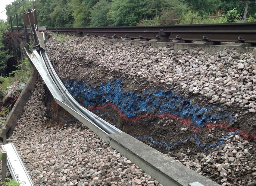
4                     Wessex Route WRCCA Plan 2020

                       Executive summary
                       Current weather events can cause significant disruption to the
                       operation of train services and damage to rail infrastructure;
                       this has a negative impact on our customers.
                       Disruption leads to delays and cancellations to           Wessex Route is committed to supporting the
                       train services, and infrastructure damage can lead        improvement of weather and climate change
                       to lines being closed to rail traffic for extended        resilience through the delivery of the route-specific
                       periods. The UK Climate Change Projections 2018           objectives. We have developed an understanding
                       (UKCP18) indicate that there will be a shift to a         of our risks by; assessing our weather-related
                       warmer climate with significant changes in sea            vulnerabilities (for example Figure 2), identifying
                       level and the pattern and intensity of precipitation      root causes of historical performance impacts and
                       across the year. Changes in the frequency and             using UKCP18 climate change projections.
                       intensity of extreme weather events and seasonal
                                                                                 Our 2014 Route WRCCA Plan set out our Route
                       patterns as a result of this could alter the likelihood
                                                                                 WRCCA Strategy, summarised the findings of
                       and severity of weather event impacts. A detailed
                                                                                 our route vulnerability and impact assessments,
                       understanding of the vulnerability of rail assets
                                                                                 detailed the CP5 investments and actions that
                       to weather events, and potential impacts from
                                                                                 we would take to mitigate these and highlighted
                       climate change, are therefore needed to maintain
                                                                                 future considerations.
                       a resilient railway.

Figure 2
Wessex Route weather
attributed delay
minutes – 2006/07
to 2018/19

                                                                                 This updated plan reports our CP5 progress, sets
                                                                                 out our plan for CP6 and beyond and updates
                                                                                 our vulnerability and impact assessments to
                                                                                 account for changes in the Network Rail WRCCA
                                                                                 Strategy and guidance.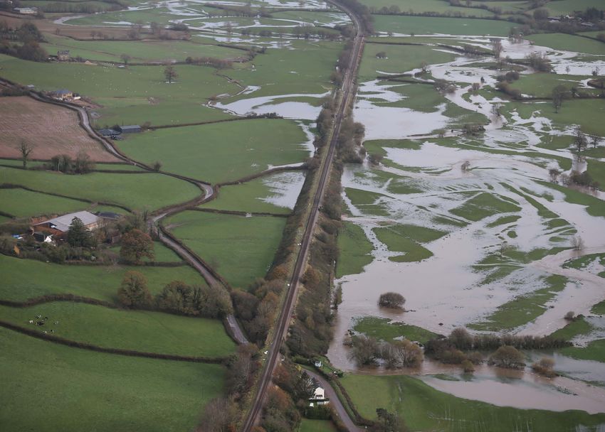
Wessex Route WRCCA Plan 2020                                                                                               5

                                   In 2017 the Network Rail guidance on the                              In CP6 Wessex Route will continue to deliver
                                   climate change projections to be used for                             works to mitigate weather and climate risk,
                                   impact assessment and planning was reviewed.                          these include;
                                   This recommended using the UKCP09 Medium
                                                                                                         •
                                                                                                           A continuation of the programme of track
                                   scenario, 90th percentile probability1. With the
                                                                                                           drainage refurbishment and renewal,
                                   release of the UKCP18 data this has been updated
                                   to the UKCP18 Representative Concentration                            •
                                                                                                           A significant programme of crest drainage
                                   Pathway (RCP) 6.0 90th percentile.                                      improvements to high risk cuttings,

                                   Key aspects of our CP5 delivery were;                                 •
                                                                                                           Pro-active scour protection works to 4No.
                                                                                                           bridges, with risk score greater than 16,
                                   •
                                     A significant pumped drainage system,
                                     constructed in 2017 at Fullwell in South West                       •
                                                                                                           Further refurbishment of coastal defences at
                                     London to address a long-standing track                               Poole Harbour,
                                     flooding problem,                                                   •
                                                                                                           Renewal of high-risk earthworks at 36 locations,
                                   •
                                     Over 135,000m of track drainage refurbishment                       •
                                                                                                           Refurbishment of high-risk earthworks at
                                     and renewal, reducing the incidence of track                          77 locations,
                                     flooding at locations throughout the route,
                                                                                                         •
                                                                                                           Culvert works including relining where required
                                   •
                                     Renewed or refurbished crest drainage to                              to 30No. poor condition culverts,
                                     the top 10 highest risk cuttings, significantly
                                     reducing landslip and derailment risk,                              •
                                                                                                           Maintenance of existing monitoring systems
                                                                                                           on high risk earthworks, and the installation of
                                   •
                                     A significant Department for Transport (DfT)                          monitoring on more high-risk sites, and
                                     funded project, constructed in 2018 to install
                                     two new bridges in the Axe Valley on the                            •
                                                                                                           Renewal of two bridges at Yetminster, Dorset
                                     Salisbury to Exeter line to reduce the frequency                      at risk of failure during flood events.
                                     of track flooding and the risk of flooding related                  During CP6 Wessex Route will continue to work
                                     embankment failure and bridge scour,                                to understand vulnerability to a changing climate
                                   •
                                     A DfT funded programme of resilience                                and to develop investment plans to address the
                                     improvements consisting of: enhanced crest                          risks in future control periods.
                                     drainage systems at Hedge End and Sway in                           Although the actions taken in CP5 improved
                                     Hampshire, and the replacement of a culvert                         aspects of our resilience, weather events continue
                                     at Sherburne Dorset with a significantly larger                     to impact our operations. Wessex Route is
                                     structure,                                                          committed to addressing the risks through the
                                   •
                                     Monitoring equipment installations at 22 high                       timely, cost efficient and safe delivery of this
                                     risk cuttings and one high risk embankment to                       Route WRCCA Plan.
                                     alert engineers to earth movement that may
                                     indicate imminent landslips,

                                   •
                                     River level monitoring equipment installations
                                     at 6 bridges at risk of flooding and scour
                                     to mitigate risk and minimize the use of
                                     operational restrictions to manage safety,

                                   •
                                     Improved scour protection to 4No. bridges,
                                     reducing the risk of asset failure,

                                   •
                                     Repair works, including relining to 2615m2 of
                                     culvert structures,

                                   •
                                     Refurbishment to 1700m2 of coastal defences
                                     at Poole Harbour.

1Previous   recommendation used in the 2014 Route WRCCA Plans was UKCP09 High scenario, 50th percentile probability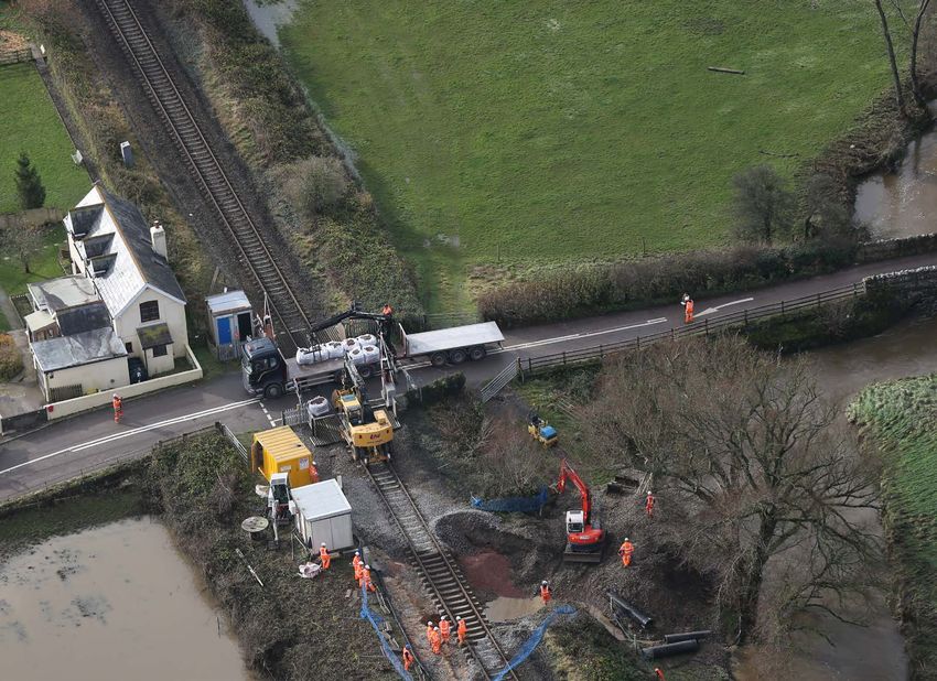
6                           Wessex Route WRCCA Plan 2020

                            Introduction
                            The railway routinely operates in a wide range of weather conditions,
                            however adverse and extreme weather can still cause significant
                            disruption to our network, resulting in significant inconvenience to
                            customers who find their planned journeys delayed or cancelled.

                            Current weather events such as extreme rainfall,       •	Heat – high temperature impacts e.g. rail
                            snow (and the resultant melt water) and high              buckles, Temporary Speed Restrictions (TSRs),
                            temperatures can cause delays, raise operating            overheated electrical components,
                            costs and increase safety risks. During Summer
                                                                                   •	Lightning strike – e.g. track circuit and signalling
                            2018 an extended period of warm, dry weather
                                                                                      damage or power system failure,
                            led to extensive desiccation damage to the
                            track in areas where the track is constructed on       •	Snow – e.g. blocked lines and points failures,
                            embankments in areas of moisture sensitive
                                                                                   •	Subsidence – the impacts of landslips, rockfalls
                            clay. This resulted in deformation to the track at
                                                                                      and sinkholes, and
                            78 locations in the Wessex Route. In February
                            2019 train services were suspended between             •	Wind – e.g. trees and other items blown onto
                            Basingstoke and Winchester for over 8 hours after         the track and into the Overhead Line Equipment
                            a heavy fall of wet snow brought down trees,              (OLE) or TSRs.
                            blocking the line.
                                                                                   As this data includes the duration and location
                            We monitor the impact of weather events on             of each disruption, and attributes cause, it gives
                            the performance of our network by using delay          a high degree of granularity for use in analysing
                            minutes and Schedule 8 delay compensation
                                                                                   weather impacts and trends.
                            costs2. Incidents are recorded under 9 categories
                            as follows;                                            In the past 13 years (2006/07 to 2018/19) the
                                                                                   average annual number of Schedule 8 delay
                            •	Adhesion – line contamination leading to
                                                                                   minutes attributed to weather for the Wessex
                               traction loss, e.g. leaf fall, moisture, oils,
                                                                                   network was 137,838. This represents 12.9% of
                            •	Cold – e.g. ice accumulations on conductor rails,   the total number of delay minutes for all causes
                               points and in tunnels,                              over that period and equates to an average annual
                            •	Flooding – standing or flowing water leading        cost of £6.5m.
                               to asset damage or preventing trains from           The impacts of severe weather events on the
    Figure 3                   accessing the track,
    Wessex Route                                                                   Wessex Route can be clearly seen in Figure 3, for
    weather attributed      •	Fog – reduced visibility obscuring signals,         example;
    delay minutes by year
    – 2006/07 to 2018/19                                                           •
                                                                                     Snowfalls of 2009 through to 2011 and
                                                                                     2017/18,

                                                                                   •
                                                                                     Wind in a number of years, but particularly
                                                                                     2013/14 and 2018/19,

                                                                                   •
                                                                                     Flooding in all years, but particularly in 2009/10,
                                                                                     2010/11, 2012/13 and 2016/17,

                                                                                   •
                                                                                     Extreme heat in 2018/19, and

                                                                                   •
                                                                                     Significant delay attributed to lightning in
                                                                                     2014/15 largely due to a single storm that
                                                                                     disabled a large signal box responsible for
                                                                                     controlling trains on a key part of the route.

                                                                                   2The compensation payments to passenger and freight train operators

                                                                                   for network disruption
Wessex Route WRCCA Plan 2020                                                                                                                      7

                                   The costs of weather attributed Schedule 8                                    Trends in the UK climate, and the UKCP18
                                   and 4 payments and the wider socio-economic                                   data, indicate that there has, and will continue
                                   impacts of rail disruption on the UK justify                                  to be, a shift to a warmer climate. Figure 4
                                   continued investments to increase current                                     illustrates the changes in frequency and severity
                                   weather resilience. Network Rail’s collaborative                              of Atlantic Winter storms and Figure 5 shows
                                   approach to understanding weather impacts in                                  observed increases in the Central England
                                   the increasingly interdependent infrastructure,                               Temperature record.
                                   societal and environmental systems is key to
                                   identifying appropriate resilience response that
                                   support our role in developing regional and
                                   national resilience.

Figure 4
Intensity and
frequency of high
latitude Atlantic
Winter storms3

Figure 5
Mean Central England
Temperature record4

3
 Xiaolan L. Wang, Y. Feng, G.P. Compo, V.R. Swail, F.W. Zwiers, R.J. Allan, P.D. Sardeshmukh. 2012. Trends and low frequency variability of extra-tropical cyclone activity in the
ensemble of twentieth century reanalysis
4
 Parker, D.E., T.P. Legg and C.K. Folland. 1992. A new daily Central England Temperature Series, 1772-1992. Int. J. Clim., Vol12, pp 317-342
8                                Wessex Route WRCCA Plan 2020

                                 Introduction continued
                                 UKCP18 projects an overall shift towards warmer   Examples of the changes are shown in Figure 6 for
                                 climates with drier Summers and wetter Winters    the mean daily maximum Summer temperature
                                 for the whole of the UK, although the level of    and Figure 7 for Winter precipitation.
                                 change will vary across the regions.

Figure 6
Change in mean daily
maximum Summer
temperature (°C) (left
to right; 2030s, 2050s
and 2070s) based
on a 1981–2000
baseline5

Figure 7
Change in Winter
precipitation (%) (left
to right; 2030s, 2050s,
2070s) based on a
1981–2000 baseline6

© UK Climate Projections, 2018
5

© UK Climate Projections, 2018
6
Wessex Route WRCCA Plan 2020                                                                                  9

                                  The potential increases in weather impacts due          For the 2014 Route WRCCA Plans, Network Rail’s
                                  to climate change support the business case             national guidance was to use the UKCP09 High
                                  for enhancing weather resilience action and             scenario, 50th percentile probability projections
                                  identifying actions that will deliver a railway that    as an appropriate benchmark on which to base
                                  is safe and more resilient to the effects of weather,   evaluations and decisions. In 2017 Network Rail
                                  now and in the future.                                  commissioned a review of its guidance taking
                                                                                          into account the Paris Agreement, advances
                                  The 2015 Paris Agreement unites nearly every
                                                                                          in climate science, additional years of climate
                                  nation in a common cause to undertake ambitious
                                                                                          observations and the then pending release of the
                                  efforts to combat climate change and adapt to
                                                                                          UKCP18 dataset.
                                  its effects. The central aim is for a strong global
                                  response to the threat that keeps the global            The conclusions of the review7 were that as we are
                                  temperature rise this century to well below 2°C         a safety critical focused organisation and a major
                                  above pre-industrial levels and to pursue efforts to    UK infrastructure manager the most appropriate
                                  limit it to 1.5°C.                                      UKCP projections to use are:

                                  The Department for the Environment, Food and            •
                                                                                            UKCP18 – RCP6.0, 90th percentile probability
                                  Rural Affairs (Defra) provides national climate           as the baseline scenario for evaluations and
                                  change guidance in a number of ways to enable             decisions, and
                                  the assessment of future climate risks and the
                                                                                          •
                                                                                            RCP8.5 90th percentile as the sensitivity test on
                                  planning of adaptation actions to maintain and
                                                                                            assets with a lifespan beyond 2050.
                                  improve resilience. Most important to Network
                                  Rail and the Wessex Route are;                          Analysis in this report has been updated to use
                                                                                          the UKCP18 projections where available. It should
                                  •
                                    The UK Climate Projection data sets which are
                                                                                          be noted that some UKCP09 parameters have not
                                    produced by the Met Office Hadley Centre, and
                                                                                          been updated in UKCP18. Where this is the case,
                                  •
                                    The National Adaptation Programme (NAP).              the UKCP09 data has been used and this is clearly
                                                                                          indicated in the report.
                                  The UK Climate Projection data sets are produced
                                  for use in assessing the future risk and impacts of
                                  the possible climate projections for the UK. They
                                  are used by government to conduct the 5 yearly
                                  UK Climate Change Risk Assessments (UKCCRA)
                                  and by individual organisations to understanding
                                  and planning for their specific risks.

7Identifying   a climate change planning scenario, JBA Consulting 22/02/18
10                     Wessex Route WRCCA Plan 2020

                       Introduction continued
                       The NAP is based upon the UKCCRA and is              Although climate change projections include
                       published by Defra every 5 years. It contains        uncertainties, associated with natural climate
                       a summary of the impacts expected for each           variability, climate modelling and future
                       sector of the UK economy and tables detailing        emissions, they and the actions from the
                       adaptation actions that the UK Government            NAP can be used to provide guidance on the
                       requires those sectors to undertake to ensure the    direction that the UK climate may take. Wessex
                       continuing resilience of the UK economy.             Route has therefore used the projections in the
                                                                            creation of this WRCCA Plan.
                       The sectorial actions are apportioned to key
                       stakeholders such as regulators and national         To ensure a consistent approach to WRCCA
                       infrastructure operators. Details of the Transport   consideration and action across Network Rail
                       Sector actions in the NAP 2018 that are              an iterative framework of key management
                       apportioned to Network Rail and hence the            stages is used (see Figure 8). The same
                       Wessex Route are included in Table 6 in the          framework has been applied to develop this
                       Wessex Route WRCCA Actions section of this Plan.     Route WRCCA plan.

Figure 8
Weather resilience
and climate change
adaptation framework                                        Strategy and
                                                                policy

                                Adaptation                Management                    Vulnerability
                                 options                   and review                   assessment

                                                               Impact
                                                             assessment
Wessex Route WRCCA Plan 2020 11
Network Rail will take a range of soft (changes The following sections provide findings from the
to processes, standards, specifications and updated Wessex Route vulnerability and impact
knowledge and skill base) and hard (engineered assessments, and detail; progress on the CP5
solutions to increase resilience) WRCCA actions resilience actions, actions planned for CP6 and
tailored to the level of risk and the strength of additional actions for future consideration.
evidence for it. Examples include;
• Do nothing/minimum – the option to do
nothing/minimum and the risks should be
evaluated,
• No regrets – increasing current and future
resilience without compromising future
flexibility,
• Precautionary – investment in adaptation now
in anticipation of future risk, and
• Adaptation pathways – staged adaptation
balancing future risk and current investment
funds through phased investment enabling
assets to be retrofitted cost-effectively in
the future.
Figure 9
Track defects resulting from desiccation in a clay
embankment near Guilford – September 201812 Wessex Route WRCCA Plan 2020
Wessex Route WRCCA Plan
Network Rail’s WRCCA Policy sets out the approach to achieving
our company’s vision of ‘A better railway for a better Britain’
by creating a railway that is safer and more resilient to weather
impacts now and in the future.
It commits the business to seeking to apply the Wessex Route Plan
following key principles;
Wessex Route is committed to including current
• Including current and future weather impacts in and future weather impacts when prioritising,
our risk analysis and investment decision making developing and delivering capital investment
and embedding climate change specifications and to ensuring that weather and climate
into policies, procedures and standards, change resilience is achieved at lowest whole life
cost, where sufficient capital budget is available
• Adapting at construction and at asset renewal,
to achieve that aim. The route is committed
designing schemes to be resilient in the most
to renewing on a like for better basis when
cost-effective manner and/or with passive
catastrophic asset failure occurs.
provision for future weather conditions,
Wessex Route has developed a register of areas
• In the event of catastrophic asset failure
and assets vulnerable to weather and climate
replacing on a like for better basis rather than
risk, these registers will be maintained and
like for like, considering the whole life cost and
improved during CP6, with mitigations for the
the best strategy for managing the railway,
highest risks developed. Where route funding
• Identifying high priority locations for proactive cannot address risks, high level investment
resilience interventions and working to identify plans will be developed, and schemes added to
funding sources for projects not included within the enhancement work bank for future funding.
agreed Control Period funding, and
Wessex Route will continue to improve operational
• Working with stakeholders to identify procedures used to mitigate weather risk and
opportunities to enhance our preparation for, will work with professional partners to develop
response to and recovery from adverse/extreme integrated plans to manage shared risks.
weather events.
Figure 10
Undertaking
temporary repairs
to a storm damaged
embankment at
Yeovil Somerset –
February 2014Wessex Route WRCCA Plan 2020 13
Wessex Route
vulnerability assessment
In the 2014 Route WRCCA Plan this section provided details of the
general vulnerability of the national rail network and Wessex Route’s
specific vulnerabilities to current weather impacts, and regional
climate change projections.
This Plan updates the vulnerability assessment
Primary event Secondary event
taking account of;
• Advances in climate science, High temperature Drought
•
Improvements in our understanding of the
impacts of weather and future climate, and Low rainfall Dessication
•
Changes in Network Rail’s climate change
policy and guidance since the last plan High rainfall Interdependencies
was published.
Sea level rise Earthslip
Network-wide weather vulnerability
The rail network and its component assets are
Low temperature Flooding
sensitive to the effects of a number of weather
types. These manifest as either primary events
Snow Erosion
(one weather type) or secondary events which
are the result of these and/or a combination of
weather types. It should be noted that these are Wind/storms Ground heave
the mechanisms by which impacts are felt, not the
actual impacts themselves. Figure 11 illustrates Lightning
the primary event types and their related
secondary event types.
Fog
Figure 11
Examples of primary and secondary events14 Wessex Route WRCCA Plan 2020
Wessex Route
vulnerability assessment continued
Managing a complex array of assets with The key findings of this work were that earthworks
varying ages, condition and weather vulnerabilities were the asset most affected by rainfall, OLE was
across a wide range of bio-geographic regions most sensitive to wind and that temperature
in a variety of climates is a complex challenge. impacted the widest range of assets. These and
Interdependencies with other sectors of the the detailed outputs behind them have been
economy, for example power, telecoms and water disseminated to Network Rail’s national asset
infrastructure add to this. function teams and the routes for use in asset
maintenance and investment planning.
Understanding current weather impacts is essential
for assessing the probable effects of climate As the above work was based upon current data the
change and for the planning and implementation changes to Network Rail’s national guidance for
of appropriate cost-effective resilience investments the climate change planning projections have not
to adapt the network to the future impacts. changed the conclusions.
The 2014 Plan outlined how we monitor the impact We continue to monitor and analyse this data and
of weather on the performance of our network by we now have a 13-year series increasing our capacity
using Schedule 8 delay compensation costs and the to discern trends in failures and performance.
process we used to carry out a detailed analysis of We have now made the raw data available and
this data to understand; we are continuing to look at how we can improve
its use including through trend and performance
• The characteristics of weather-events that
reporting on a period, quarter an annual basis.
trigger failures,
• The thresholds at which failure rates change, and
• Trends in the failures of assets and the
performance of the network.Wessex Route WRCCA Plan 2020 15
Route weather vulnerability
Wessex Route has some specific vulnerability to The repeated seasonal expansion and contraction
severe weather. The western parts of the route can also, over long periods, push over retaining
pass through difficult topography requiring the walls and results in embankments becoming
original railway builders to use numerous deep, lower and wider over many years. This requires
steep cuttings, tunnels and large embankments maintenance to maintain track geometry more
to maintain acceptable gradients. To minimize intensively than in areas with more stable geology.
construction costs the lines were routed down river
Southern parts of Wessex Route pass through the
valleys where possible, this has resulted in this part
tidal flood zone, this causes infrequent disruption
of the route suffering from a high risk of earthslips
at present, however future risk must be quantified
and flooding in wet weather conditions. This risk
so that appropriate plans can be made before the
is raised further by the effect the Blackdown Hills
risk of tidal flooding and coastal erosion becomes
has on locally increasing rainfall rates, and the
unacceptable. During CP5 a study was undertaken
east west orientation of the Route in this area
to quantify the coastal flooding and erosion risk
that means that storms tend to track along the
and some erosion protection work has been
line resulting in flooding in multiple locations.
progressed at Poole Harbour.
Roads in the area are also prone to flooding and
earthslip often making it difficult or impossible for Specific vulnerabilities on the Wessex Route to
maintenance staff to access sites to quickly rectify weather impacts include high-risk earthworks
problems. All tunnel approach cuttings on this line on the Salisbury to Exeter line. This area of the
had crest drainage improved during CP5 to reduce network passes through the Blackdown Hills
the risk of landslip, and all of these cuttings have which are prone to failure during periods of
also had monitoring installed during CP5 to alert heavy rain due to very soft geology and over
engineers should a landslip occur. steep earthworks. Honiton tunnel is a good
example of the challenge in managing these
In large areas at the eastern part of the route
assets. Improved drainage has been constructed
the underlying geology is of moisture sensitive
during CP5, and the most vulnerable areas are
clay, a material that is prone to softening
programmed for investment in CP6 to arrest
and expanding in wet Winter conditions and
active landslips in the cutting. Similar conditions
shrinking when desiccated, a risk in dry Summers.
exist on parts of the Weymouth to Bristol line and
This results in an elevated risk of landslip
elsewhere on the route.
in wet Winters and difficulty in maintaining
track geometry in late Summer and early Autumn.
Figure 12
Honiton tunnel
earthwork failure –
February 201216 Wessex Route WRCCA Plan 2020
Wessex Route
vulnerability assessment continued
Large sections of the Salisbury to Exeter line near Several bridges within the route are at higher risk
Axminster run in the River Axe flood plain. Some of of flood damage including those at Yetminster
the embankments and up to nine river crossings in on the WEY line and at the River Frome on the
this area require modification to reduce the risk Bournemouth main line. The Yetminster bridge
of flood damage. The embankment near Broom will be replaced in early CP6, but due to technical
Level Crossing was strengthened with sheet piles constraints the new bridges will not offer
in CP4 to reduce the chance of washout at this significantly improved performance during flood
location in the future. In 2018 two new bridges events. While the bridges remain at significant
were built, one at Broome Level Crossing and one risk of inundation, they will however feature more
at Axe Farm Level Crossing to reduce the risk of resilient construction, therefore reducing the risk of
future embankment failure. The line remains at asset failure during flood events, and reducing the
significant risk of flooding due to the increasing time taken to re-open the line following flooding.
river flows and the low height of the embankments River level monitoring via Remote Condition
throughout the area. Monitoring (RCM) and a robust procedure to
stop traffic when river levels are unsafe will be
maintained to ensure safety.
Figure 13
Track washout at
Broom Crossing,
Axe Valley –
November 2012
Figure 14 Figure 15
Construction of new Yetminster bridge
railway bridge in the during high river
Axe Valley to reduce flows – January 2008
future flood impact –
September 2018Wessex Route WRCCA Plan 2020 17
Recent severe Winters have exposed the route to function has entered into an agreement with the
significant flooding. The line at Datchet was closed EA to build the ‘on railway’ portion of this project
for several days in early 2014 as a result of the River consisting of removal of all railway infrastructure
Thames experiencing the highest levels recorded from the new bridge locations, construction of
for over 40 years, reminding all that significant the two new bridges and reinstatement and
parts of Greater London are at risk of flooding. commissioning of railway assets and systems.
The Environment Agency (EA) has designed a
Large parts of the route near the South Coast are
scheme to improve the flood performance of
vulnerable to sea level rise including sections of
this section of the Thames. The EA is planning to
line near Poole Harbour and the Portsmouth line
undertake significant works in late CP6 to reduce
as it approaches through Portcreek Junction and
the flood risk to communities in the Datchet area.
crosses Portcreek Viaduct. This viaduct will require
This will require the construction of two new
replacement before mid-century as track level is
bridges under the Windsor and Eaton Riverside
currently predicted to be below flood levels at
branch and a new river channel adjacent to the
that time and is below the crest level of the new
railway to connect these two bridges to the main
flood defences recently constructed to protect
river channel. Wessex Route is actively engaged
Portsmouth from rising sea levels.
with the project. Network Rail’s Capital Delivery
Figure 16
Portcreek viaduct
at high tide – month
not known 2018
Large parts of Wessex Route are built on moisture The BKE line forms part of the strategic freight
sensitive clay. Embankments constructed from this network and there is no freight diversion due to
material are prone both to conventional failure restricted gauge on all alternatives. Significant
when saturated in Winter but also to desiccation works are required to improve resilience of the
where track quality is very difficult to maintain in BKE line and in order for this work to take place a
dry Summer and Autumn conditions. This affects freight diversion is likely to be required to facilitate
several lines but is most pronounced on the BKE sufficient access to undertake such significant
line between Reading and Basingstoke, the GTW work. Desiccation is likely to be an increasing
line from Guildford to Ash, the NGL line from challenge to manage as longer, drier Summers
Guildford to Surbiton, the ETF line from Eastleigh with higher average and peak temperatures lead
to Fareham, the BAE2 line from Gillingham to to increased desiccation and therefore more
Yeovil, and elsewhere on the route, including the shrinkage which is likely to lead to more track
BML line between Wimbledon and Woking. quality issues.18 Wessex Route WRCCA Plan 2020
Wessex Route
vulnerability assessment continued
Wessex Route is largely DC electrified and this Heat speeds are currently well managed and
technology although extremely resilient in most most jointed track has been removed from heavily
conditions is prone to icing. The worst effect trafficked parts of the route with the small areas
occurs when rain falls on a conductor rail that is of jointed track remaining largely programmed
below freezing. This happens infrequently but the for removal in CP6. Maintenance work is
consequences are very disruptive, particularly if programmed to minimize formation disturbance
this occurs early in the morning before rail traffic during the Summer months. Increased
is busy enough to clear ice as it forms. Conductor maintenance volumes in CP6 will allow the
rail icing is likely to be a reducing problem in the track to enter the Summer period with better
future, and well targeted rail head treatment with geometry and more consistent stressing,
hydrophobic products can significantly reduce increasing resistance to desiccation and high
the impact of these conditions by preventing temperatures. As average temperatures increase,
water freezing to the con-rail. DC electrification the length of Summer in effect lengthens, and
is also unreliable if flooding occurs, this is likely the window for intrusive track maintenance
to increase in frequency unless significant will reduce. This will be a significant challenge for
improvements are made to the drainage asset. maintenance teams who do not currently have
The areas of the route most at risk from coastal access to any additional maintenance shifts
flooding are DC electrified. During CP6 the impact in Winter.
of this emerging risk must be better understood
As embankments weather they tend to become
and plans drawn up to mitigate them in the long
narrower at the crest and over time they settle.
term. A significant proportion of snow related
Most current track maintenance practices
delay in Winter 2018/19 was as a result of
maintain the height of or raise the track, and the
coppiced hazel in chalk cuttings overturning onto
position of the track must be maintained over
track and blocking the line. This vegetation cannot
structures. These factors together have resulted
be removed as it is valuable dormouse habitat,
in parts of the route suffering from having no
but it can be managed in a way that prevents it
space at the crest for a safe cess and insufficient
posing a risk to the passage of trains.
space to maintain a compliant ballast shoulder.
Figure 17 As temperatures increase, we must find a
Pinks Hill embankment cost-effective way to lower track in areas where
failure – July 2014
this is possible, so it fits on the underline bridges
and embankments, or undertake works to make
space for the track formation on the narrow
embankments. The lack of cess width in places
not only makes maintaining track difficult, it
increases the chance of track buckling during hot
weather, therefore requiring speed restrictions
during hot weather to manage safety. A narrow
cess also increases the chance of earthwork
failures during wet weather, such as at Pinks
Hill near Guildford which failed in July 2014
following a very wet Winter.Wessex Route WRCCA Plan 2020 19
One of the most significant weather-related
safety and performance incidents in recent years
was the St Jude storm of the 27th and 28th October
2013; this brought down hundreds of trees across
the route. If storm intensity and frequency
increases, the impact of such weather events will
be significant unless the number of trees able to
fall on the line, both owned by Network Rail and
third-party owned, is reduced.
Summer 2018 was the driest recorded for
Wessex Route since we started tracking Soil
Moisture Deficit in 2000. The extended dry period
coincided with the highest number of days with
an average temperature over 20°C, 29 days
exceeded this threshold. The previous highest
number of days over 20°C was 22 days, recorded
in 2003 and in 2017. This run of hot dry weather
had a devastating impact on performance as
desiccation led to a significant upturn in track
defects needing a speed restriction to manage
safety. During September 2018 there were up to
Figure 18
62 speed restrictions imposed; this led to a PPM Track impacted by desiccation between Guilford and
attrition of over 3%. Ash – Summer 201820 Wessex Route WRCCA Plan 2020
Wessex Route
vulnerability assessment continued
Future climate change vulnerability
The complexity of the relationship between UKCP18 provides regional projections across
weather events and climate means that the 13 administrative regions in Great Britain
UKCP18 data set cannot forecast future weather (Figure 19), The Wessex Route falls within two of
events. It projects modelled probabilistic trends these regions, South East England and South West
that can be used to understand the potential England. These regions are therefore considered
future risks associated with certain climates and as representative of the route for the purposes of
the likely changes in weather events/parameters. analysing future climate projections.
Network Rail therefore uses projections from the
In the 2014 Plan charts were generated using the
UKCP18 data set as a future baseline to understand
UKCP09 High emissions 50th percentile probability
potential risks and for making informed strategic
scenario for the two regions to show the projected
decisions to increase future weather resilience.
changes in temperature and precipitation from
the 2020s to the 2080s relative to the baseline
climate of the 1970s (1961-1990).
For this report the charts and associated narrative
have been updated to match the current Network
Rail climate change guidance which uses the
current UKCP18 climate projections where
available. Replacing the UKCP09 emissions
scenario used in the 2014 report with the UKCP18
emissions scenarios noted in the introduction has
involved a number of changes to the data used.
These include:
•
Using a new baseline period of 1981-2000,
•
Moving from projection time periods of
30 years (2020, 2050, 2080) to shorter
20-year periods (2030, 2050, 2070), and
The use of UKCP18 RCP 4.5 95th percentile
•
data for sea level rise as a proxy for RCP 6.0
data (UKCP18 did not model RCP 6.0 for
sea level rise).
Figure 19
Map of UK administration
regions used in UKCP188
8
Source: Met Office © Crown Copyright 2019 [available from UKCP18 Guidance: Data availability,
access and formats: https://www.metoffice.gov.uk/binaries/content/assets/metofficegovuk/pdf/
research/ukcp/ukcp18-guidance-data-availability-access-and-formats.pdf]Wessex Route WRCCA Plan 2020 21
Mean Daily Maximum Temperature change South East England
The mean daily maximum temperature for both The highest mean Summer temperatures are
regions is projected to increase in every month expected to be in August for both the 2050s
of the year, with the greatest increases expected and 2070s with increases of 4.6°C to 26.4°C
in the Summer months. This increase becomes and 6.3°C to 28.1°C respectively. In Winter the
larger across the century. highest mean temperatures will be seen in
December, with increases of 2.1°C to 10.1°C and
2.9°C to 10.9°C respectively.
Figure 20
South East England,
mean daily maximum
temperature change
(°C) (RCP 6.0 90th
percentile)22 Wessex Route WRCCA Plan 2020
Wessex Route
vulnerability assessment continued
South West England
The highest mean daily maximum Summer In Winter the highest mean temperatures will be
temperatures are expected to be in August for seen in December for the 2050s, with increases of
both the 2050s and 2070s, with increases of 2.0°C to 10.4°C and February by the 2070s with
4.5°C to 25.0°C and 6.2°C to 26.8°C respectively. increases of 3.6°C to 11.3°C.
Figure 21
South West England,
mean daily maximum
temperature change
(°C) (RCP 6.0 90th
percentile)Wessex Route WRCCA Plan 2020 23
Mean Daily Minimum Temperature change South East England
The mean daily minimum temperature for The highest mean daily minimum temperatures
the regions is also projected to show increases for Summer are expected to be in August, with
throughout the year with the highest in Summer. increases of 3.1°C to 15.0°C by the 2050s and
The level of increase is expected to become higher 4.6°C to 16.5°C by the 2070s. The lowest mean
across the century. minimum temperatures will still occur in February
with expected increases being 2.5°C by the 2050s
to 3.6°C, and by 3.5°C by the 2070s to 4.5°C.
Figure 22
South East England,
mean daily minimum
temperature change
(°C) (RCP 6.0 90th
percentile)
South West England
The highest mean daily minimum temperatures minimum temperatures will still occur in February
for Summer are expected to be in August, with with expected increases being 2.7°C by the 2050s
increases of 2.9°C to 14.7°C by the 2050s and to 4.3°C, and 3.8°C by the 2070s to 5.5°C.
4.5°C to 16.3°C by the 2070s. The lowest mean
Figure 23
South West England,
mean daily minimum
temperature change
(°C) (RCP 6.0 90th
percentile)24 Wessex Route WRCCA Plan 2020
Wessex Route
vulnerability assessment continued
Mean daily precipitation South East England
The UKCP18 narrative for mean daily precipitation In the 2050s and 2070s December will be the
in the regions is of significantly wetter Winters wettest month with mean daily rainfall increases
and drier Summers. Network Rail’s chosen climate of 34.8% to 3.8mm/day and 50.3% to 4.2mm/
change planning scenario (RCP 6.0 90th percentile) day respectively. The driest month will be July
shows the upper range of Winter rainfall showing decreases of 48.6% to 0.8mm/day by the
increases, but it does not illustrate the highest 2050s and 51.3% to 0.7mm/day by the 2070s.
potential Summer rainfall reductions. These are
best represented by the RCP 6.0 10th percentile
projections. Figure 24 and Figure 25 therefore
plot the RCP 6.0 50th percentile projections with
error bars that indicate the wider range of change
associated with the 10th and 90th percentiles.
Figure 24
South East England,
mean daily
precipitation change
(%) (RCP 6.0 50th
percentile with the
wider range showing
the 10th and 90th
percentiles)Wessex Route WRCCA Plan 2020 25
South West England
In the 2050s and 2070s December will be the The driest month will be July showing decreases
wettest month with mean daily rainfall increases of 45.1% to 1.0mm/day by the 2050s and 54.5%
of 27.2% to 5.4mm/day and 38.4% to 5.8mm/day to 0.8mm/day by the 2070s.
respectively (and in the 2070s, both January and
December receive 5.8mm/day).
Figure 25
South West
England, mean daily
precipitation change
(%) (RCP 6.0 50th
percentile with the
wider range showing
the 10th and 90th
percentiles)26 Wessex Route WRCCA Plan 2020
Wessex Route
vulnerability assessment continued
Storm intensity and river flows
In addition to changes in total rainfall, climate climate change data, however, at the time of
change is also expected to increase the frequency publishing this plan the guidance is still based
and severity of river flooding events and individual on the UKCP09 Medium Emissions scenario. This
rainstorm events, Summer rainstorms will show recommends that rainstorm intensities for the
the largest increases. Wessex Route regions should be increased by
10% for the 2050s and 20% for the 2080s.
The EA produces guidance on the rainstorm
Climate uplifts9 for river flows are provided by river
intensity and river flow uplifts that should be used
basin and those relevant to the Wessex Route
to account for climate change. This guidance
regions are shown in Table 1.
is being reviewed due to the release of UKCP18
Table 1 River basin 2050s uplift 2080s uplift
River flow uplifts
Thames 25% 35%
(UKCP09)
South East England 30% 45%
South West England 30% 40%
Sea level rise South East England
Sea level varies around the coast due to Margate will see the highest rises by 2050 and
differences in coastal morphology and isostatic 2070 of 34.8cm and 53.1cm respectively and
rebound since the last ice age. As this also affects Brighton will see the lowest at 34.6cm and 52.9cm.
the degree of sea level rise, UKCP18 projections
have been obtained for 3 coastal locations in
both of the administrative regions covered by the
Wessex Route10.
Figure 26
Sea level rise
projections for
South East England
(cm) (RCP 4.5 95th
percentile)
9
EA higher central climate change estimate as the most comparable to Network Rail’s climate change planning scenario.
10
Sea level rise data in UKCP18 is not available for RCP 6.0, instead RCP 4.5 is used as a proxy on the recommendation of the Met Office.
This is the most compatible with the Network Rail Primary planning scenario.Wessex Route WRCCA Plan 2020 27
South West England
Penzance will see the highest rises by 2050 and
2070 of 36.5cm and 55.6cm respectively and
Weston-Super-Mare will see the lowest at 34.1cm
and 52.2cm.
Figure 27
Sea level rise
projections for
South West England
(cm) (RCP 4.5
95th percentile)28 Wessex Route WRCCA Plan 2020
Wessex Route impact assessment
This section provides an update of the Wessex Route weather impact
assessment findings published in the 2014 Wessex Route WRCCA
Plan, including annual performance impacts and identification of
higher impact locations on the Route.
Performance impacts
The impact of weather events on our network’s restrictions to be used to mitigate safety risk when
performance is monitored using delay minutes a threshold is exceeded. This generates a lot of
and Schedule 8 delay compensation costs as delay versus the published timetable, whereas for
proxies. As this data includes the duration and landslip (recorded in S8 data as subsidence) failures
location of each disruption, and attributes cause, often block lines, and the costs of recovering from
it gives a high degree of granularity for use in landslip can run into several £million for a single
analysing weather impacts and trends. site. A project to identify the true cost of weather
and climate change disruption and recovery is
It is acknowledged that Schedule 8 has limitations
being progressed in CP6.
in recording the true cost of weather and disruption
and does not account for the full cost of severe In the 2014 plan eight financial years of Schedule
weather events. Schedule 8 disproportionately 8 data were analysed to give an assessment of the
represents impacts that lead to delay, rather than weather impacts for the Wessex Route. This Plan
those that close lines. Wind is over represented updates that assessment using additional data
as operational processes require blanket speed from the past 5 years, see Figure 28.
Figure 28
Wessex Route weather
attributed Schedule
8 costs – 2006/07 to
2018/19Wessex Route WRCCA Plan 2020 29
The updated analysis shows that wind continues There is a high degree of confidence in the UKCP18
to be the most significant weather impact costing projections for temperature, rainfall and sea level
a total of £22.4m in the last 13 years. This is rise, but lower levels for wind, lightning and snow
around one third or so more than the costs of fall. Planning for the latter parameters should
adhesion and flooding and more than double still be undertaken, but outputs should be more
that of snow and cold related incidents which cost flexible to acknowledge the higher possibility of
£15.4m, £12.2m, £10.5m and £9.9m respectively alternative climate outcomes.
over the same period.
The findings from the combined analysis of
Climate modelling cannot provide future weather current weather impacts and UKCP data (UKCP09
forecasts, but it does give us projections for the for wind, lightning and snow and UKCP18 for
trends in future weather patterns. Combining temperature, precipitation and sea level rise will
these trends with our analysis of current weather be used in the prioritisation of resilience actions
impacts allows us to understand the future as summarised in Table 2 below.
vulnerability and possible impacts upon the
Wessex Route.
Table 2 Impact Schedule Climate projections12 Prioritisation
Prioritisation of 8 Cost per
weather-related year11
impacts on Wind Average £1.73m Changes difficult to project, however generally expected to increase High
Wessex Route Highest £6.91m
Adhesion Average £1.19m Complex relationship between multiple causes and their climate Medium
Highest £2.57m projections
Snow Average £0.82m Changes difficult to project, but increases in Autumn, Winter and Spring Medium
Highest £3.73m minimum temperatures suggest reduced snow days
Lightning Average £0.56m Changes in storms difficult to project, however generally expected to Medium
Highest £3.18m increase
Cold Average £0.76m Increases in mean minimum daily temperatures across the regions Low
Highest £2.14m in Autumn, Winter and Spring ranging from 1.8oC in April to 2.9oC in
September for the 2050s and 2.7oC in April to 4.6oC in September for
the 2070s
Subsidence Average £0.25m Increases in mean daily rainfall across the regions for late Autumn, Winter High
Highest £0.72m and early Spring months, for example; 13.2% in April and 39.8% in
January by the 2050s becoming 16.7% in April and 56.3% in January by
the 2070s
Decreases in mean daily rainfall for late Spring through to early Autumn,
for example; 26.3% in May and 49.3% in August by the 2050s becoming
37.2% in May and 58.4% in August by the 2070s
Increased frequency and intensity of Winter and Summer storms
Heat Average £0.27m Increases in mean maximum daily temperatures across the regions Medium
Highest £1.87m range from 2.0oC to 2.5oC (Winter) and 2.9oC to 4.6oC (Summer) by the
2050s. In the 2070s this becomes 2.8oC to 3.6oC and 4.4oC to 6.3oC
respectively
Flooding Average £0.94m Increases in mean daily rainfall for late Autumn through to early Spring High
Highest £3.60m and increased intensity and frequency of Winter and Summer storms
(see subsidence)
Fog Average30 Wessex Route WRCCA Plan 2020
Wessex Route impact
assessment continued
Identification of higher risk locations Heat impact assessment
Since the publication of the last Plan the Wessex Between 2006/07 and 2018/19 heat related
Route network has continued to experience incidents accounted for an average of 4,745 delay
extreme weather events that have challenged minutes and £0.27m in Schedule 8 costs per year.
weaknesses in our assets and operations. Climate This is 3.4% of Wessex’s annual average weather-
change projects more frequent and intense related delay minutes and 4.1% of the annual
extreme weather events, so understanding the average cost.
impacts of current and future events is critical to
Track asset
investment decision making.
As we experience longer periods of dry and hot
The impacts of weather on our Route are captured
weather, the management of the track asset needs
via analysis of the delay minute and Schedule 8
to change. The increasing number of train services
cost data and the outputs of this allow high impact
coupled with our desire to minimise passenger
frequency/cost sites to be identified and targeted
disruption means that the track asset needs to be
for detailed assessment to:
managed in a way that makes it more resilient to
•
Verify the attribution of the delay(s) to a the changes in weather the Route is experiencing
weather impact(s), than was previously the case.
•
Determine the root cause of the delay, The management of the track asset will now need
to include more robust preparation in advance
•
Identify if resilience action has been taken in
of the Summer. This will comprise completion
the past or is already planned, and
of hot weather preparation works to eliminate
•
Generate and prioritise appropriate resilience deficiencies such as unstressed rails and ballast
actions. shortages earlier in the spring, and to improve
geometry. The management of track geometry
In addition to the above assessments Wessex
and ballast disturbance works will need to
Route has also identified potential future risks
be reduced in Summer to help prevent track
and resilience actions based on climate change
buckles. Any shortfall in this activity leads to staff
projections and Route knowledge.
being deployed on watchman duties and speed
Combining these findings allows us to proactively restrictions being imposed – the more extreme
identify potential investments that would address temperatures get, the wider the need for blanket
current weaknesses and mitigate and/or enable speed restrictions.
the mitigation of future risks. This approach is
critical to creating a railway that is safer and more The current process and framework with which
resilient to weather impacts now and in the future. we balance the risks of track geometry faults and
track buckle needs to evolve. The development
and delivery of requirements set out for the hot
weather preparation of the track asset needs
to achieve a reduction in the overall number of
deficiencies and specifically target no deficiencies
on certain parts of the network. Requirements
for the management of the track asset during
prolonged periods of hot and dry weather also
need to be made more robust – giving front line
teams clearer guidance on the management of
deteriorating track geometry versus track buckle
risk. Network Rail standards will also need to be
reviewed and updated as part of this process.Wessex Route WRCCA Plan 2020 31
Vegetation Buildings
Although current research is not advanced enough As the year will become warmer on average in all
for us to be able to understand the detailed seasons, and heatwaves will increase in frequency,
risks and impacts of climate change on our line intensity and duration, the current building stock
side vegetation at this time, we can make some will require modification or enhancement to provide
general assumptions that allow us to consider our an internal environment suitable for customers,
responses going forwards. staff and equipment (for example electrification,
signalling and vital communications equipment).
As the year will become warmer on average in all
Much of our current lineside and depot building
seasons, growing patterns will change significantly
stock comprises lightweight modular buildings
over time. Some species may not tolerate the new
with poor thermal performance
local conditions and their distribution patterns
may change. Long lived species, for example some Longer dryer Summers will lead to increased
broad leaved trees will potentially be less able to desiccation, this is likely to represent an increased
adapt. There is also emerging evidence that some risk of desiccation related subsidence to buildings
tree diseases, such as Ash die back, are increasing constructed on moisture sensitive clay.
in prevalence due to climate change induced tree
Wetter Winters and a greater frequency of intense
stress. If the health of trees suffers they will need
rainfall events will test the water tightness of the
to be felled to manage safety risk, this is likely to
building stock and it may be necessary to upgrade
be both very expensive and will require careful
rainwater goods, particularly on large station and
management to protect organisational reputation.
train shed roofs.
In areas where currently dominant vegetation
dies back, or is removed, there is the potential for Structures
pioneer species to colonise the rail corridor. Many Longer dryer Summers will lead to increased
of these are likely to grow vigorously in the warmer desiccation, this is likely to represent an increased
prevailing conditions and may potentially grow for risk of desiccation related subsidence to structures
more of the year. Under these circumstances the constructed on moisture sensitive clay.
intensity of lineside management may need to
increase to maintain rail safety. Changes in species As structures tend to have a significant operational
range may also introduce species completely new life the predicted temperatures are outside the
to the UK, potentially including species injurious range envisaged when many of the current
to health. More vigorous growth would mean structures were designed and constructed. Some
that core safety activity such as examination structural elements will expand beyond design
of earthworks, drainage and structures may be limits, initially freezing expansion joints, then
more difficult if the asset is obscured by greater generating significant stresses and strains within
vegetation growth year-round. This could drive the structures for which they were not designed.
a greater need for vegetation management. Our The impact of this is currently poorly understood
ability to achieve such management may face as each structure is unique and calculating the
greater constraints if the bird nesting season shifts impact of such heat induced load would require
or expands. Changes in our lineside habitats and work on a structure by structure basis, with high
the wider climate issues may mean that we will quality survey data available.
need to consider changes in our current vegetation
management practices, for example; we may not
wish to leave significant cut and chipped material
on site due to increased risk of line side fires.You can also read