Southernmost Weather Reporter - National Weather Service Weather Forecast Office Key West, FL
←
→
Page content transcription
If your browser does not render page correctly, please read the page content below
Southernmost Weather
      Reporter

   National Weather Service
   Weather Forecast Office
         Key West, FL
Southernmost
                  Weather Reporter
                  National Weather Service                           · Key West, FL
   Welcome to the January 2021 Edition!
                                                                                                  JANUARY 2021
                                                                                               INSIDE THIS EDITION:

Shortly after the last edition of the Southernmost Weather Reporter was published             Welcome                 1
(March 2020), the COVID-19 pandemic completely transformed everyday life within a
                                                                                              Covid-19 Decision
few months of the beginning of the 2020 Atlantic Hurricane Season. At your Florida Keys                               2-3
                                                                                              Support
National Weather Service (NWS), we quickly implemented measures to ensure the
health and safety of our team and to maintain operational readiness for executing our         Staff Changes           3
mission of delivering weather, water, and climate data, information, and knowledge in         “Civilian in the
support of decisions and actions protecting lives and livelihoods in the Florida Keys and                             4
                                                                                              Spotlight” Award
across the adjacent coastal waters. We implemented mandatory telework for certain
                                                                                              Sofia de Solo           4
positions and shifts, moved computer workstations to facilitate greater physical
separation of mission-essential staff, established guidelines for wearing facial coverings,   Lexia Williams          5
maintaining physical distancing, and increased hygiene, cleanliness, and disinfection
                                                                                              Heritage Project        5
protocols. We suspended public tours and in-person outreach, educational, and
coordination visits, and transitioned to virtual meetings. We are grateful for the            Peripheral Impacts of
                                                                                                                      6
expertise and guidance from the dedicated career officers and scientists with the U.S.        Tropical Cyclones
Public Health Service, Centers for Disease Control and Prevention, National Institutes of     Mark Webb               7
Health, and Monroe County Health Department.
                                                                                              “Learning Lunches”      7
The 2020 Atlantic Hurricane Season was expected to be busy, and it delivered, with            Wet May 2020            8
record-breaking numbers. Despite being threatened several times by tropical storms
                                                                                              Florida Keys
and hurricanes between July and November, the Florida Keys escaped any hurricane              Hurricane History
                                                                                                                      8
impacts. Nevertheless, Florida Keys NWS staff were very busy as tropical cyclones Isaias,
Laura, Sally, Delta, and Eta all threatened the Florida Keys during their evolutions. Our     Hurricane Season
                                                                                                                      9-10
                                                                                              2020
team sprang into action with each threat, releasing extra weather balloons, updating our
followers on social media, providing quality marine weather forecasts to the maritime         National Ocean Ser-
                                                                                                                      10-11
community, producing web graphics highlighting threats and                                    vice Rafting Award

potential impacts, and providing e-mail briefings and                                         Marine Partners
                                                                                                                      11
telephone consultations to core partners. The 2020                                            Workshop
hurricane season is over, and as we turn the corner, from
                                                                                              Keren Rosaso-Vazquez 12
2020 into 2021, I would like to extend best wishes to all for a
happy and healthy new year!                                                                   Hot Summer 2020         12

                                                                                              NOAA Hollings Scholar 13
Sincerely,
                                                                                              Justin McReynolds       14

Kennard “Chip” Kasper                                                                         CoCoRaHS                14
Meteorologist-in-Charge                                                                       Sally Rainfall          15
NOAA/Florida Keys National Weather Service
                                                                                              Florida Diversity and
                                                                                                                      16
                                                                                              Inclusion Workshop
Long-Duration Impact-Based Decision Support During
      the Covid-19 Pandemic in Monroe County

                                                   By: Jon Rizzo

When you think of the local emergency response to a pandemic, images of emergency managers and first
responders meeting frequently with public health and safety subject matter experts come to mind. However, did
you know that a team of local meteorologists was among them?

 That’s right! Your Florida Keys National Weather Service (NWS) rapidly responded with its all-hazards support
approach to the growing information needs of Monroe County Emergency Management and first responders once
the Emergency Operations Center (EOC) became established in mid-March 2020. As the EOC established a
rigorous schedule of planning and tactical meetings, in my role as Warning Coordination Meteorologist at the
Florida Keys NWS, I was present virtually to develop a plan for long-term response as well as identify short-term
hazardous weather vulnerabilities. As medical knowledge concerning the pandemic grew, challenges emerged as
health safety guidance and directives concerning social distancing, personal protective equipment and
teleconferencing technology were set by each of the responding stakeholders and subject matter experts’
agencies.

Early in the response, weather information needed for response
personnel working and storing protective equipment under
temporary structures resulted in briefings and a supporting
Weather Impact Matrix product. The Weather Impact Matrix,
originally used by the Florida Keys NWS to provide first responders
with a hazardous weather outlook during the week-long Fantasy
Fest festivities in Key West, was adapted with modified thresholds
coordinated through the Monroe County Covid-19 Response’s
Safety Officer.

Soon afterward, a more immediate life-safety information evolved
once the Monroe County resident and worker access checkpoints           Telework setup early during the Covid-19
were established on U.S. Highway 1 and Card Sound Roads. A 24-         pandemic. Here, multi-tasking, attending a
hour direct notification service on critical weather hazards and       briefing provided by Naval Air Station Key
warnings to the Monroe County Sheriff's Office supervisors was               West Capt. Sohaney while also
provided, as the Florida Keys NWS’ dedicated operational               participating in our office’s annual tropical
meteorologists in Key West stood the watch for hazardous weather.                   season workshop.
The checkpoints, consisting of shade tents, law enforcement, fire
rescue, and public works crews, faced several hazards, including
one severe thunderstorm with wind gusts approaching 60 mph and hail. The notification enabled the checkpoint
commands to make immediate life-safety decisions to halt activities and seek shelter in their vehicles until
dangerous weather passed. The notification service was expanded temporarily to include the Monroe County
Public Works department, storing and distributing protective gear until a more substantial enclosed facility could
be readied for storage. The combination of real-time weather monitoring, short-term hazardous weather warning
and notification, and my role as WCM for planning formed the meteorological support network for Monroe County
and Florida Keys municipalities to continue their pandemic response safely and efficiently.

                                                   (Continued on page 3)

Southernmost Weather Reporter ~ Florida Keys National Weather Service ~ January 2021                              2
Long-Duration Impact-Based Decision Support During
    the Covid-19 Pandemic in Monroe County (continued)

    Even as the need for 24-hour notification faded with the discontinuation of the checkpoints, the continuing response
    into the summer months meant a new concern: A forecast active hurricane season. Coordination began with tropical
    cyclone briefings as well as review of service delivery to the Monroe County and municipal emergency management
    agencies. The Weather Impact Matrix was expanded to include tropical weather outlook information.

    While the Monroe County Covid-19 response evolved into longer planning periods, the Florida Keys NWS transitioned
    the Weather Impact Matrix to support the Monroe County Health Department for Covid-19 testing events.

    The continuing Monroe County response to the pandemic led to improvements in the Florida Keys NWS’ ability to
    support our core partners remotely. A variety of collaborative teleconferencing and meeting tools, including those
    operated by both the NWS and Monroe County, have enabled your local NWS office to share and store briefings as
    references. The practice of countywide stakeholder meetings, led by the Monroe County Emergency Management,
 Bahia Honda State Park Temperature Observations Return
    led to direct communication with all levels of the response and media. And, partnerships strengthened at the
    Monroe County Public Information Officer Roundtable in late 2019 and the NWS Florida Keys’ Integrated Warning
    Team Workshop in January 2020 resulted in direct collaboration and instant “chat” contact with public information
    officers representing a large number of agencies and departments serving the Florida Keys. These strong
    relationships led to more frequent and robust service delivery for incidents outside the pandemic, including for
    Tropical Cyclones Laura and Eta.

    So, when you learn about local first responders and your local emergency managers ramping up during a long-term
    non-weather situation, you know local subject matter experts are ready to provide scientific guidance and support.
    Among them is a whole team of NWS meteorologists, based right here at home in the Florida Keys, standing the
    hazardous weather watch and at the ready for long-duration support to help our partners protect life and property.

    2020 Florida Keys National Weather Service Staff Changes

                                                    By: Bryce Tyner
In 2020, there were several staff changes at the Florida Keys National Weather Service:

•     Stephen Chesser accepted a position as a Meteorologist at the Central Weather Service Unit in Miami, Florida. He
      completed his tenure at the Florida Keys National Weather Service in July 2020.
•     Katherine Lenninger accepted a position as a Meteorologist at the National Weather Service Office in Houston, TX.
      She completed her tenure here in October 2020.
•     Mark Webb accepted the Information Technology Officer position in July 2020.
•     Justin McReynolds and Keren Rosado-Vazquez started their new roles as Meteorologists in October and November
      2020, respectively.
•     Dan Milner, Electronic Systems Analyst, retired at the end of 2020. Dan completed 38 years of federal service,
      including 12 years with the United States Air Force and over 25 years with the National Weather Service.

We wish the best to those moving on to new opportunities. For those joining the Florida Keys National Weather Service,
we embrace you with a warm welcome!

     Southernmost Weather Reporter ~ Florida Keys National Weather Service ~ January 2021                                3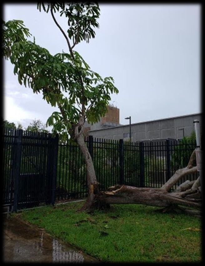
Naval Air Station Key West “Civilian in the Spotlight”: Jon Rizzo

                                                      By: Chip Kasper
 On February 6, 2020, Capt.Mark Sohaney, Commanding Officer, Naval Air Station (NAS) Key West, visited the Florida
 Keys National Weather Service to recognize Warning Coordination Meteorologist, Jon Rizzo, as “Civilian in the
                                                   Spotlight”. Jon was recognized for his meteorological knowledge,
                                                   local expertise, and excellent briefing skills in support of the
                                                   emergency management and command staff of NAS Key West
                                                   during the approach of Hurricane Dorian in September 2019. NAS
                                                   Key West’s national security mission supports operational and
                                                   readiness requirements for Department of Defense, Department
                                                   of Homeland Security, National Guard units, other federal
                                                   agencies, and allied forces. NAS Key West is the U.S. Navy’s
                                                   premier training facility for tactical aviation squadrons. Local
                                                   aerial ranges enable aviators to engage in training maneuvers
                                                   within minutes of takeoff. The station is equipped with a
                                                   sophisticated tactical combat training system, which tracks and
                                                   records combat aerial maneuvers. In addition, NAS Key West is
                                                    the host facility for numerous tenant activities, including the Joint
    Capt. Mark Sohaney, Commanding Officer of       Interagency Task Force-South and the U.S. Army Special Forces
   NAS Key West, presents Warning Coordination      Underwater Operations School. Congratulations, Jon, on this
    Meteorologist, Jon Rizzo, with the award for    recognition!
             “Civilian in the Spotlight”.

                Getting to Know the New Staff: Sofia de Solo

What were you doing before joining the team at the Florida Keys National Weather Service (NWS)?
I received my acceptance to the Pathways program during my first year of graduate school at Mississippi State
University, where I was beginning my research on rapidly weakening tropical cyclones. Prior to joining the team at the
Florida Keys National Weather Service, I have interned with the Air Force Hurricane Hunters, the Environmental
Modeling Center, and the Hurricane Research Division.
Where do you see yourself in ten years?
In 10 years I wish to have established a well-respected career within the National Weather Service from a sunny and
warm location. This includes being fairly involved in outreach and diversity programs. I, one-day, would like to fly
regularly into hurricanes with either the NOAA or Air Force Hurricane Hunters. The timeline of that goal is still
uncertain but I hope to have a better idea by then! With an established career, I also hope to dive deeper into my non-
meteorological passions. I see myself owning a boat and maybe pursuing a side job in sports journalism.

What do you like to do in your free time?
I love to be near the water! I love boating, fishing, sitting on the beach, kayaking, and catching sunrises/sunsets. I am
also a bigtime baseball fan and spend much of my time at Marlins Park. During baseball off-season, I enjoy playing
some slow pitch softball, myself.

  Southernmost Weather Reporter ~ Florida Keys National Weather Service ~ January 2021                                      4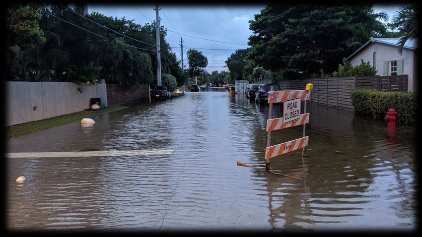
Getting to Know the New Staff: Lexia Williams

What were you doing before joining the team at the Florida Keys National Weather Service (NWS)?
Before joining the Florida Keys National Weather Service, I was working on completing my masters degree in Natural
Hazards and Catastrophes at the University of Miami while completing my thesis "Statistical Analysis of Wind and
Pressure Fluctuations for Hurricane Matthew (2016), Hurricane Irma (2017), and Hurricane Dorian (2019)" and
working in the service industry in Asheville, North Carolina. I was also active in research at my previous internship at
the State Climate Office of North Carolina, where I also had the opportunity to present several research projects at
both national and school-based conferences.
Where do you see yourself in ten years?
In ten years, I hope to still be working for the Florida Keys National Weather Service, as Key West quickly has become
my home. I hope to begin building relationships with my local community members and core partners while becoming
more active in educational outreach and in the various programs that the office has to offer. If I happen to no longer
be at this office, I would like to still be working for the organization at another National Weather Service office or
working for the National Hurricane Center in Miami, as tropical meteorology has been a passion of mine for as long as
I can remember. Aside from my career goals, I hope to obtain my own personal goals by having a family of my own
that will also support me and my dreams.
What do you like to do in your free time?
In my free time, I enjoy getting out and exploring the various views that the Florida Keys have to offer while taking my
camera out and capturing memories. I also enjoy spending a good portion of my free time either in the water or at the
beach. When I am not exploring or in the water, I like to spend time with my close friends, whether that involves
movie nights, trying the many restaurants that the islands have to offer, or making dinners of our own.

 Southernmost Weather Reporter ~ Florida Keys National Weather Service ~ January 2021                                 5
Peripheral Impacts of Tropical Cyclones in the Florida Keys

                                                    By: Sandy Delgado

 It is a natural reaction to worry more about tropical cyclones that are forecast to make landfall in the Florida Keys
 than those that are expected to give a glancing blow to the island chain. After all, it is in the core of hurricanes
 where you find the strongest winds and most damaging storm surge. Regardless, the peripheral impacts of tropical
 cyclones should not be taken lightly. This past hurricane season, a few tropical cyclones passed close enough to the
 Florida Keys to cause important impacts, including the very heavy rainfall produced by what would eventually
 become Hurricane Sally as it passed to the north.

 In late August, Tropical Storm Laura passed about 200 miles south of the Lower Keys near the southern coast of
 Cuba on a westward track toward the Gulf of Mexico. Outer rainbands moved across the Florida Keys, bringing
 spells of heavy rain, tropical-storm-force wind gusts, and rough seas. The highest wind gust was measured at our
 office in Key West, 69 mph! Only minor damage was reported across the island chain. A strong high pressure
 system over the western Atlantic kept Laura south of the Florida Keys, but it also caused a tight pressure gradient
 across the island chain. This pattern resulted in persistent strong, to near-gale breezes (25-38 mph) across the
 Florida Keys. .

 In 2008, Hurricane Gustav crossed western Cuba, passing well
 southwest of the Lower Keys. Gustav still was able to produce
 wind gusts to tropical storm intensity in the Lower and Middle
 Keys. However, Sand Key, about 8 miles southeast of Key West,
 reported sustained winds of 56 mph and wind gusts to 74 mph.
 About two weeks later, Hurricane Ike passed at about the same
 distance from the Keys as Gustav with similar wind impacts.

 Ike did bring another danger associated with the outer
 rainbands of tropical cyclones: tornadoes. Two tornadoes
 impacted the Florida Keys. Similarly, Hurricane Mitch in 1998
 produced two tornadoes when it passed over 100 miles north
 of the island chain. Back in 1972, Hurricane Agnes passed over
 250 miles west of Key West. The outer rainbands produced a
 few tornadoes that impacted the island chain. Unfortunately,
 the tornadoes occurred at night and around 40 people
 sustained injuries in Big Coppitt Key.

 In summary, it is very important to be prepared and vigilant
 even when the tropical cyclone is not expected to make landfall
 in the Florida Keys.                                                 Tree damage due to a 69 mph wind gust
                                                                       observed at the Florida Keys National
                                                                     Weather Service office on August 24, 2020.

 Southernmost Weather Reporter ~ Florida Keys National Weather Service ~ January 2021                                  6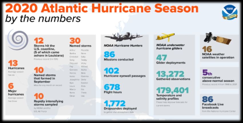
Getting to Know the New Staff: Mark Webb

What were you doing before joining the team at the Florida Keys National Weather Service (NWS)?
Before joining the team at the National Weather Service here in Key West, I served as an Information Technology
Analyst for the U.S. Army and Department of Defense at Fort Knox, Kentucky. I had the privilege of serving the Army
Human Resources Command, which maintained over 150 applications running on over 1500 servers that kept the Army
Human Resources operation running smoothly. We also built and maintained the Goarmy.com website on premises.
Where do you see yourself in ten years?
Finally getting on board with NOAA and the National Weather Service has been a dream of mine for many years, and
having made it to the Florida Keys, I don’t see myself going anywhere in the near future. Being in the beautiful Florida
Keys makes that statement even more likely to come to fruition. In one word, “here”, the answer is here.
What do you like to do in your free time?
The last few years have seen my interest change. I have become an avid scuba diver, one of the primary factors of
wanting to move to the Keys. If I’m not diving, I’m working on my project boat (endless) or talking to one of my
grandchildren on Messenger. Other than that, I’m learning a new computer skill (yes, that’s a hobby) or playing a video
game (you’re never too old).

        Florida Keys NWS Begins “Learning Lunch” Series

                                                     By: Chip Kasper
The National Weather Service (NWS) is a science
agency that depends on its experts to convey
relevant knowledge to partners and the general
public for the purpose of protecting lives and
property. As such, the NWS is a “learning
organization” where continuous learning and
improvement is necessary to keep up with the
growing need by partners for weather
intelligence. The arrival of several new staffers at
the Florida Keys NWS in the middle of the COVID-
19 pandemic inspired the creation of a weekly
“Learning Lunch”, an informal virtual forum where
our staff routinely meet to exchange ideas, share
knowledge, and learn from each other. Fifteen             Florida Keys NWS Meteorologist Lexia Williams presents her
                                                        research working with the State Climate Office of North Carolina
learning lunches have been held so far in 2020, with
                                                                as part of the Friday “Learning Lunch” program.
presentation formats including short seminars,
science project updates, core partner overviews,
diversity and inclusion presentations, and informal discussions. The learning lunches are about an hour in duration,
and include time for questions, answers, and discussion. Notes are taken, shared with the entire staff (including those
not present), and archived. In 2021, we plan to expand the range of topics to include both colleagues in the weather
enterprise and core partners. If you are interested in being a guest presenter, please contact Chip Kasper at
kennard.kasper@noaa.gov.

 Southernmost Weather Reporter ~ Florida Keys National Weather Service ~ January 2021                                 7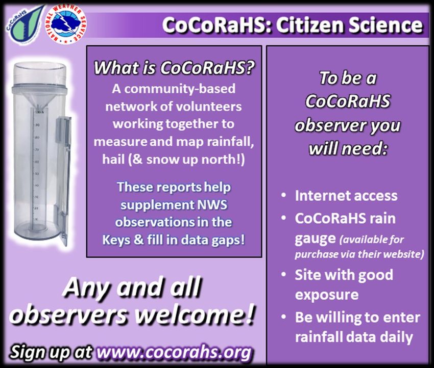
Wet May 2020

                                                      By: Sandy Delgado

It is not unusual to have a rainy month of May in the Florida Keys. After all, the month typically marks the beginning of the
rainy season. Furthermore, it is not unusual for the heavy rain to be caused by a tropical or subtropical cyclone. In 2018, for
example, rains from Subtropical Storm Alberto allowed Key West to have the wettest May since climate records began in
1871. In 2020, two disturbances affected the island chain and brought record rainfall, especially to the Middle Keys and
parts of South Florida. Both disturbances would later develop into the season’s first tropical cyclones, Arthur and Bertha,
off the southeast coast of the United States.

On May 10th, a weak cold front that was the predecessor for Subtropical Storm Alberto moved across the Florida Keys,
bringing showers and thunderstorms to the island chain. The cold front commenced the rainy season after a very dry
winter. The airport in Marathon received 2.81 inches of rain on May 10th, not only shattering the daily record of 0.69
inches but making it the 10th wettest day in May. The weak front continued southward, stalling over the Bahamas and
Cuba. However, on May 13th, showers and thunderstorms began to increase over western Cuba and moved slowly
northward into the Florida Straits, affecting the Florida Keys. Very heavy rains affected the Florida Keys on May 14th. On
that day, the Marathon airport received 5.76 inches of rain, not only obliterating the previous daily record of 1.20 inches,
but it also made May 14th the 2nd wettest May day ever.

Another frontal boundary, the origins for Tropical Storm Bertha, moved across the Florida Keys on May 19th. Showers and
thunderstorms increased in the Western Caribbean Sea over the next couple of days and gradually lifted northward on May
22nd and 23rd, affecting the Florida Keys. The storm activity became more prominent on May 24th, extending from the
eastern Gulf of Mexico to the Bahamas, causing heavy rains in southern Florida and the island chain. Marathon airport
received 3.45 inches of rain on that day, surpassing the
previous record of 2.30 inches set in 2001. On May 25th, heavy
rains affected the Middle and Upper Keys, with some locations
receiving 5 to 10 inches.

The disturbances that affected the Florida Keys resulted in the
wettest May on record for much of the island chain. The
heaviest precipitation occurred in the Middle Keys, with some
reporting stations recording over 20 inches of rain. Marathon
International Airport received 15.66 inches of rain, 3.35 inches
above normal, and surpassed the monthly record of 15.47
inches set in 1968. In the Upper Keys, most islands received 10
to 15 inches of rain, with isolated spots reporting higher
amounts. Similarly, 10 to 15 inches were recorded in the
eastern Lower Keys. In the rest of the Lower Keys, rainfall                       May rainfall (inches) from
amounts of 4 to 10 inches were more common.                                    Florida Keys observing locations.

Southernmost Weather Reporter ~ Florida Keys National Weather Service ~ January 2021                                           8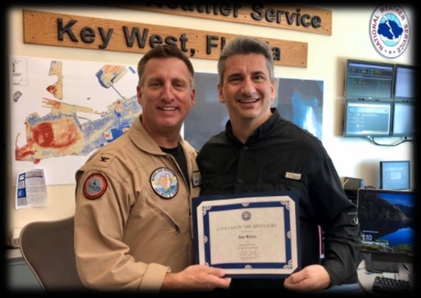
2020 Hurricane Season: A Year of Records

                                                 By: Sandy Delgado

The 2020 Hurricane Season goes into the record books as one of the most active ever recorded in the Atlantic
basin. In total, there were 30 named storms of which 13 became hurricanes and 6 major hurricanes. Five major
hurricanes reached at least Category Four intensity. In comparison, an average hurricane season sees around 12
named storms, 6 hurricanes, and 3 major hurricanes. The active nature of the hurricane season did not come as a
surprise, as all pre-season forecasts were calling for an active or hyperactive hurricane season. In May, NOAA
predicted 13-19 named storms, 6-10 hurricanes, and 3-6 major hurricanes.

These forecasts were based on the indication that either neutral or La Nina conditions would be present through
the hurricane season, which makes the equatorial waters of the Pacific Ocean cooler than normal. The lack of an El
Niño typically means less wind shear across the tropical Atlantic Ocean and more favorable conditions for tropical
cyclone development. Water temperatures in the tropical Atlantic basin were also above normal and the
environmental pressures below normal. These factors are typically a recipe for a very active hurricane season.

              Some statistics from the historic 2020 Atlantic hurricane season (courtesy: NOAA).

The Southeast Untied States had 12 landfalling tropical cyclones, eclipsing the 1916 record of 9. Most of the U.S.
impacts occurred along the Gulf Coast. The most significant was Hurricane Laura, which made landfall in southwest
Louisiana in late August with maximum sustained winds of 150 mph, a powerful Category Four storm. Laura was
the most intense hurricane to make landfall in Louisiana since 1856. Hanna, Isaias, Sally, Delta and Zeta were also
hurricanes when they made landfall. Sally’s slow movement across south Florida brought very heavy rainfall as the
system slowed down to a crawl as it approached the Alabama and NW Florida coasts. Zeta made landfall in
southeastern Louisiana as a strengthening Category 2 hurricane, despite the storm moving over cooler shelf
waters. Zeta moved over New Orleans, and the National Weather Service office in Slidell was actually able to
release a rare weather balloon inside the eye of the hurricane. Zeta was a quick-moving hurricane, which largely
limited its impact.

                                             (Continued on page 10)

Southernmost Weather Reporter ~ Florida Keys National Weather Service ~ January 2021                              9
2020 Hurricane Season: A Year of Records (continued)
The Florida Keys were spared of significant impacts despite the number of tropical cyclones that impacted the Gulf
of Mexico and western Caribbean Sea. The Island Chain experienced peripheral impacts from a few tropical
cyclones, including Isaias, Laura, and Sally. Eta was the only system to make landfall in the Keys, occurring in Lower
Matecumbe Key on November 9th with maximum sustained winds of 65 mph. Eta had a large eye visible on radar,
but the southern side was quite weak, and most of the weather was on the north side. There was some damage
reported in Key Largo, especially to trees.
Statistics of the 2020 Hurricane Season:
• 30 named storms was the most ever recorded, surpassing
the 28 named storms that occurred in 2005
• Twelve tropical cyclones made landfall in the United
States, breaking the record of nine set in 1916
• Five named storms formed in July, tying the record of five
set in 2005
• Ten named storms formed in September, breaking the
record of eight set in 2002, 2007, and 2010
• Alpha became the first recorded named storm to make
landfall in Portugal
• Four major hurricanes developed after October 1st; the
Tracks of all tropical cyclones in 2020 previous record was two in 2005
(courtesy: National Hurricane Center). • Eta and Iota became major hurricanes in November, the
first recorded occurrence
• Iota became a Category Five hurricane in November, only the second time a Category Five hurricane has been
recorded in November
• Iota was also the latest recorded Category Five hurricane on record
• Ten tropical cyclones underwent rapid intensification (increase in maximum sustained winds of at least 30 knots in
24 hours), tying the record set in 1995
Florida Keys NWS Team Wins National Ocean Service
Peer Recognition Rafting Award
By: Chris Rothwell
The National Ocean Service (NOS) selected Daniel Milner (Electric Systems Analyst), Martin Rieman (Electronics
Technician), Chris Rothwell (Lead Meteorologist), and Chip Kasper (Meteorologist-in-Charge) of the Florida Keys National
Weather Service (NWS) for the 2020 NOS Peer Recognition Rafting Award. This award recognizes coordination among NOS
offices and provides NOS employees the opportunity to express their appreciation to another NOS or NOAA colleague who
has helped them in some way. Their NOS Peer Recognition Rafting Award was preceded by a NOAA Employees and Team
Member of the Month Award in June of 2020.
The Florida Keys NWS routinely works with several NOAA line offices in support of the common mission. In this case, the
team collaborated with the NOS to assist them in safely replacing a mission-essential sea surface temperature sensor at
the NOAA/National Water Level Observation Network station at Key West Harbor in the midst of the Covid-19 pandemic
and government-wide travel restrictions.
(Continued on Page 11)
Southernmost Weather Reporter ~ Florida Keys National Weather Service ~ January 2021 10Florida Keys NWS Team Wins National Ocean Service
Peer Recognition Rafting Award (continued)
The important environmental monitoring sensor at the Key West station failed at the end
of March 2020. Chris Rothwell consulted with Field Engineering Technician Jack Marshall
(NOS/Center for Operational Oceanographic Products and Services/Field Operations
Division in Gulf Breeze, Florida), to identify a course of action to quickly and efficiently
replace the sensor. This course of action returned the critical data feed, which NOAA
scientists and partners use for a variety of purposes, including environmental monitoring,
validating satellite-derived measurements, and provision of marine impact-based decision
support services to emergency managers, water resource managers, and other federal,
state, and local partners. After receiving the new sensor via express shipping and arranging Electronics Technician,
for site access from NOS/Florida Keys National Marine Sanctuary staff, Rothwell joined Martin Rieman, aids in
Milner and Rieman at the Key West Harbor station, which is only a short distance away the repair of the sea
from the Florida Keys NWS forecast office. Mindful of safe physical distancing, the NWS surface temperature
team of Rothwell, Milner, and Rieman (on site) and NOS Affiliate Jack Marshall (via sensor for
telephone) executed Marshall’s thorough instructions, removing the old sensor from the Key West Harbor.
cable conduit, and installing a replacement sensor to precision depth in only two hours. On
May 8, 2020, the SST data feed at Key West Harbor (one of the oldest stations in the network) was fully restored.
This award represents a unique way to recognize the tremendous work the Florida Keys NWS team has done in support
of the NOS and NOAA mission.
Florida Keys NWS Attends Partners Workshop at the
Tropical Analysis and Forecast Branch
By: Chris Rothwell
Early in March of 2020, as Marine Program leader at the Florida Keys
National Weather Service (NWS), I attended a marine partner workshop
at the Tropical Analysis and Forecast Branch (TAFB) located at the
National Hurricane Center (NHC). Senior operations managers from
Carnival, Royal Caribbean, Norwegian, Crowley Marine, Tote Maritime,
Foss Maritime, and others, in conjunction with representatives from
Weather Forecast Office (WFO) Miami, WFO Key West, TAFB, NHC,
Ocean Prediction Center, Port Meteorological Officers, and United
States Coast Guard District 7, met to discuss operational products and
decision support deficiencies across the NWS enterprise. One of several
items of note, I observed how the larger ship companies rarely use the
10 meter, 2-minute average surface wind speed (the standard wind
Nearly three-dozen participated in the height and averaging period for the World Meteorological Organization)
2020 Marine Partners Workshop at TAFB. for forecasts and ship routing, which is not applicable to the larger
freighters, tankers, and tugs. Instead, operations managers rely on the
30, 60, and 90 meter winds to assess on-the-ocean conditions for their larger ships. In addition to learning ways to
improve NWS products and services, the forecasters and industry professionals took part in a hurricane avoidance
exercise, which tasked teams with finding routes away from the path of a simulated strengthening hurricane in the
Western Caribbean.
Southernmost Weather Reporter ~ Florida Keys National Weather Service ~ January 2021 11Getting to Know the New Staff: Keren Rosado-Vazquez
What were you doing before joining the team at the Florida Keys National Weather Service (NWS)?
Before joining the Florida Keys National Weather Service, I was a University of Miami / Cooperative Institute for Marine
and Atmospheric Studies (CIMAS) postdoctoral fellow affiliated to NOAA’s Atlantic Oceanographic and Meteorological
Laboratory (AOML) Hurricane Research Division (HRD). As a postdoc, I worked in the implementation and testing of the
National Centers for Environmental Prediction (NCEP’s) Advanced Bending Angle Method (NABAM), and its inclusion
into the operational version of the Finite Volume Cubed-Sphere dynamical core Global Forecasting System (FV3GFS)
Gridpoint Statistical Interpolation (GSI) to improve the assimilation of Radio Occultation (RO) observations.
Where do you see yourself in ten years?
Joining the NWS has been a dream come true to me. I was missing the action packed days of weather as a researcher.
In ten years, I see myself as a NWS Science and Operations Officer (SOO). It will be great to incorporate my research
experience with the operations related to the office. I would like to enhance the breach between operations-to-
research and research-to-operations.
What do you like to do in your free time?
Most of the time, I am training for a race such as a triathlon, half marathon, or a marathon. I also like trying new
restaurants and spending quality time with my family.
Hot Summer 2020
By: Dave Ross
Summer 2020 entered the record books for Key West as the warmest summer on record. With an average
temperature of 86.1°F, it ended up 2 degrees above the 30-year normal. While the days were warm, as to be expected
during the summer, an abundance of warmer than usual nights really helped to boost the average temperature for
this period. For June, July, and August, the official climate reporting site for Key West (Key West International Airport)
saw a month’s worth of warm low temperature records.
These 32 records at Key West far outweighed the seven
similar records recorded at the Florida Keys Marathon
International Airport, the official climate reporting site
for Marathon. They did, however, see several more daily
high temperature records than Key West. In addition to
Key West, two other Keys’ sites saw their warmest
summer on record from June through August. Bahia
Honda State Park and John Pennekamp State Park
cooperative observing sites came in 2.6 and 2.5 degrees
above normal, respectively, claiming the top spots in Summary of daily records that were either set or tied at
their 15-year periods of record. Key West and Marathon during summer 2020
Key West did see one other record that stands out this
past summer, an elusive cool temperature record. On July 21st, a high of 84 degrees was recorded at Key West, tying
the daily cool high temperature record. Perhaps unsurprising, this was on a day that Key West set a new daily rainfall
record of 2.35 inches. The last time Key West set or tied one of these records was on May 26th, 2018.
Southernmost Weather Reporter ~ Florida Keys National Weather Service ~ January 2021 12NOAA Hollings Scholarship Provides
Opportunity for Research-to-Operations Collaboration
By: Bryce Tyner
Mr. Benjamin Fellman, who is pursuing a degree in Atmospheric Science at Millersville
University, was selected as a prestigious 2020 NOAA Hollings Scholar. For his six-week research
project, he chose to work with Florida Keys National Weather Service Science and Operations
Officer, Andy Devanas, and myself as his co-mentors. Although COVID-19 forced the program to
be conducted virtually, we decided to move forward with the research, with the project officially
beginning in May 2020.
Waterspouts pose a significant hazard to mariners, and perhaps nowhere in the world are
waterspouts more frequent in the wet season months of May-September than the Florida Keys.
Using 1200 UTC daily weather balloon upper-air sounding data from Key West, previous
research at the Florida Keys National Weather Service resulted in the development of a logistic
A waterspout regression (statistical) model to predict the probability of observing a waterspout in the Florida
observed by Keys on a given day. Although the resulting Waterspout Index is a valuable tool for
helicopter pilot meteorologists working in operations on a given day in the Florida Keys, the study was limited
Luis Folgueira on due to it only using data from one point in the Florida Keys (Key West). However, the radiosonde
Sept. 24, 2016. location at Key West was found to be statistically representative of the Florida Keys island chain
and surrounding waters.
In the Florida Keys, subtle differences in both the small-scale (on the order of
1-100 miles) and large-scale (on the order of 100-1000 miles) environment
can result in very different meteorological impacts. The 2020 Hollings research
project aimed to examine some of the large-scale conditions that provide
favorable conditions for the development of waterspouts in the Florida Keys.
For part of his research, Ben used both statistical compositing analysis to
examine the potential link of waterspout frequency in the Florida Keys to a
defined parameter known as the Bermuda High Index (BHI). The BHI is quite
simply a measure of the difference in sea level pressure at Bermuda and at Waterspout frequency as a function of
New Orleans, Louisiana, with positive values indicating higher sea level BHI for wet season days 2007-2016. The
pressure at Bermuda than at New Orleans. orange line highlights the mean daily
waterspout frequency of 0.2.
Ben used data for the wet seasons between 2007-2016 and examined
observed waterspout frequency for three bins: a negative BHI (< 0), a weak positive BHI (0-4.9), and a strong positive
BHI (>4.9). Using a statistical test of significance known as a Fisher’s Test, he showed a statistically significant drop off in
observed waterspout frequency when the BHI was strongly positive. To provide a meteorological cause for such a
relationship between observed waterspouts and BHI, Ben used composite analysis to compare the large-scale
environments for days with a negative BHI, weak positive BHI, and a strong positive BHI. One of his key discoveries was
that days with a strong positive BHI tend to have much weaker northerly and/or easterly (or even southerly and/or
westerly) wind components relative to climatology, whereas days with a negative and weak positive BHI tend to have
stronger northerly and easterly wind components. It is speculated that the strength and position of the Bermuda High
likely results in producing conditions more favorable for waterspout formation.
We are continuing to move forward with this research. Mr. Jonny Benoit, who is pursuing his Geophysics degree at
Brown University, will join the Florida Keys National Weather Service as a NOAA Hollings Scholar in the summer of
2021. For his research, he will continue examining the large-scale patterns that ultimately result in favorable conditions
for waterspouts in the Florida Keys, using statistical techniques and in-depth case studies of past waterspout outbreaks.
Southernmost Weather Reporter ~ Florida Keys National Weather Service ~ January 2021 13Getting to Know the New Staff: Justin McReynolds
What were you doing before joining the team at the Florida Keys National Weather Service (NWS)?
Before joining the Florida Keys National Weather Service, I was in that strange summer Covid-19 limbo “vacation”
immediately following my graduation from Florida State University in May of 2020. While in Tallahassee, I worked
with Dr. Bob Hart researching the asymmetrical decay of a tropical cyclone’s wind field at landfall for my Master’s
research project. I was also a teacher’s assistant for a synoptic meteorology class and a meteorological instruments
and observations course, as well as an instructor of a weather discussion course and an introductory meteorology
lab. During my final semester at Florida State, I volunteered at the Florida Division of Emergency Management
(FDEM) as the Intern Meteorologist, where I got my first official taste of the operational application of meteorology.
Where do you see yourself in ten years?
Honestly, a lot is going to happen in the next ten years! Joining the National Weather Service has been a long-time
dream for me, so I am in the process of figuring out my next big thing. To accomplish that, I want to explore the
different roles in the office to see what I gravitate towards with my specific skill sets. From some of my time at the
University of Oklahoma and FDEM, I have an interest in getting involved with Decision Support Services and
examining the products used to inform the public about severe and dangerous weather. I could see using the
experience I get over this decade along with some research as a tool to help streamline messages and products so
that they are easier for the intended audience to see and digest. On the flipside, I am curious about forensic
meteorology and how we can tell how drastic an event is versus others. One thing is for sure, I will have learned a lot
by the time this decade has passed, and I wouldn’t want it any other way!
What do you like to do in your free time?
I am blessed to be very well-traveled during vacations, whether it be close to home in the Florida theme parks or
farther away in parts of Europe and the edges of the US. I have been a singer for most of my life and have experience
playing cello, electric bass, and the piano, which I use for song writing when I have time. I enjoy watching college
football (Boomer Sooner!) along with any sort of action, fantasy, and sci-fi movies or shows. I am also pretty big into
games of the PC, Switch, and Dungeons and Dragons variety.
Did you know that our office also contributes rainfall
measurements to The Community Collaborative Rain,
Hail, & Snow Network (CoCoRaHS)? Our White Street
facility in Key West (across from City Hall) manually
measures 24-hour rainfall at midnight standard time
every day of the year. These reports are then submitted
to the online CoCoRaHS database, one of 22 such
observation sites in the Florida Keys.
Southernmost Weather Reporter ~ Florida Keys National Weather Service ~ January 2021 14Rainfall Associated with Eventual Tropical Storm Sally
By: Dave Ross
Deep cumulus convection associated with developing
Tropical Depression 19, on Friday, September 11th
continued to increase across the Straits of Florida and
Florida Keys into the early morning hours of Saturday,
September 12th. By Saturday midday, Tropical Storm Sally
was born near East Cape Sable, Florida. By this time, over
11 inches of rain had fallen in portions of the Upper Keys,
with similar amounts recorded across Key West and its
vicinity by late Saturday evening.
Flooded roadways
Flooded roadwaysnear Atlantic
near AtlanticBoulevard
Boulevard in
Widespread ponding of water and street flooding Key WestinonKey September 12th,
West on Sept. 2020.
12th, 2020.
escalated in Key West during a short period with
exceptional rain rates (1.10” in 10 minutes ending at 9:43
PM EDT and 3.98” in 60 minutes ending at 9:56 PM EDT) as thunderstorm outflow reached the island chain from
the south. Residents reported stalled cars, popped manhole covers, and residential flooding in low-lying areas of
Key West that evening, with the intense convective rain finally diminishing just before midnight.
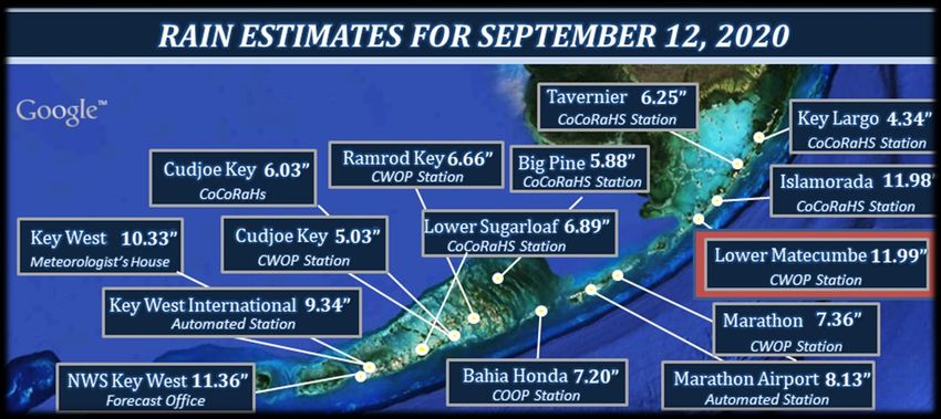
Of note, the 11.36 inches of rainfall measured at the Florida Keys National Weather Service office on White Street
in Key West is the wettest day on record since observations at the facility began in September 2005. While this
may be a short period of record, it is significant in that it was over 4 inches greater than the next wettest day, 7.00
inches on October 23, 2008.
For the Key West climate location (Key West International Airport ASOS) 9.37 inches of rainfall was a dual record. It
shattered the daily record for September 12th of 2.26 inches from 1924. It is also now the wettest September day
on record, surpassing the previous record of 7.47 inches on September 10, 1919. In addition to these two new
titles, it became the 5th wettest day ever recorded in Key West, with records dating back to 1871. The wettest day
on record for Key West is November 11 1980, when 22.75 inches of rainfall was measured.
The Marathon climate location (Florida Keys Marathon International Airport) was not to be left out, also setting a
record for any September day. The daily rainfall total of 8.13 inches was more than 7 times the previous daily
record of 1.13 inches set in 1995. Until
this year, the wettest September day was
September 28, 1953, when 5.92 inches of
rainfall was measured. With records
going back to 1950, this rain-soaked day
also now ranks as the 3rd wettest day
ever recorded for the Marathon area.
August 24, 1995 remains the wettest day
on record for Marathon, with 8.33 inches
of rainfall.
Rainfall totals for Sept. 12th, 2020.
Southernmost Weather Reporter ~ Florida Keys National Weather Service ~ January 2021 15Inaugural NOAA Florida Diversity & Inclusion
Workshop Held Virtually
By: Luis Ingram-Westover
The inaugural NOAA Florida Diversity & Inclusion (D&I)
Workshop was held on Tuesday, June 2nd, 2020. Given the
Covid-19 pandemic, the workshop was transitioned to a
virtual event. Despite the change, we had a successful event
with a variety of topics presented by outstanding speakers
and panelists with decades of combined experience in D&I,
including Catalina Martinez (Regional Program Manager at
the NOAA Office of Ocean Exploration and Research) , Richard
“Pete” Hill (National Weather Service Director of the Equal
Opportunity and Diversity Management Division), Earl Breon
(WFO Indianapolis), Amneris Caba (Equal Employment
The planning committee of the First NOAA Florida Opportunity and Diversity Specialist in the NOAA Office of
Diversity & Inclusion (D&I) Workshop, from the top Inclusion and Civil Rights), Dr. Vernon Morris (Howard
left: Krizia Negron (WFO MLB), Molly Merrifield (MFL University Professor Emeritus and incoming Director of the
WFO MFL), Jeffrey Lewitsky (NHC TAFB), myself (KEY School of Mathematical and Natural Sciences at Arizona State
WFO KEY), and Dr. Nelsie Ramos (NHC TAFB). University), Dr. Sim Aberson (Meteorologist of NOAA's AOML
Hurricane Research Division), Kenneth Bailey (Director of
NOAA OICR), and myself (WFO Key West and NWS Diversity
Ambassador for LGBTQ+ and Hispanics). Some topics covered included unconscious bias, creating a respectful
workplace, the importance of self-awareness to improve how we relate to others, and making the workplace more
diverse and inclusive using empathy and sympathy.
Though there are benefits to having these kinds of workshops in person, we have demonstrated that holding a virtual
workshop can be just as beneficial and effective in reaching more people who might have been unable to attend
otherwise. The feedback received from
participants, speakers, and panelists was
overwhelmingly positive, which propelled us to
consider extending more opportunities like this
in the future. One participant noted having the
workshop 100% virtual had a positive impact on
the participants, as they felt more compelled to
participate and express their true feelings,
questions, and concerns about D&I.
Our utmost gratitude goes out to all the
speakers, panelists, and participants for their
time and commitment participating in this
workshop. The commitment to bring forth an
open, honest discussion with each other is what
made this workshop truly great and will carry us
forward on the path to further promote diversity
and inclusion. We hope you will be inspired to
continue these conversations at your workplace
as you go forward in your daily lives.
Comments from select attendees of the
Florida Diversity & Inclusion Workshop.
Southernmost Weather Reporter ~ Florida Keys National Weather Service ~ January 2021 16National Weather Service
Weather Forecast Office
1315 White Street
Title Text Key West, FL 33040
Tel: (305) 295-1316
Subtitle Text
Fax: (305) 296-2011
Contact Us:
Email:
Web: www.weather.gov/key
sr-key.webmaster@noaa.gov
Facebook: NWSKeyWest Twitter: @NWSKeyWest
6th Addition Editors:
Bryce Tyner, Meteorologist
Christopher Rothwell, Lead Meteorologist
Laura Kasper, ASA/Meteorologist
Southernmost Weather Reporter ~ Florida Keys National Weather Service ~ January 2021 17You can also read