Guidelines for DOC Volcanic Risk Management in Tongariro National Park - Some information in this document has been withheld under section 9 (2) ...
←
→
Page content transcription
If your browser does not render page correctly, please read the page content below
Photo by Paul Dawson

   Guidelines for DOC Volcanic Risk
 Management in Tongariro National Park

Some information in this document has been withheld under section 9 (2)
(a) of the Official Information Act
GUIDELINES FOR DOC VOLCANIC RISK MANAGEMENT IN TONGARIRO
                               NATIONAL PARK

                                                                                          Department of Conservation
 Document Control                                                                          Tongariro District Office
 Document Ref: DOC-1130183

 Revision      Date                        Description                       Author        Reviewed           Approved
   No.

   1.0       November            Draft Adapted from Tongariro –
               2012            Ngāuruhoe Response Plan DOCDM-
                                 1039463 And incorporating key
                              elements of former EDS and ERLAWS
                                              plans

   2.0      August 2013                     Re-Drafted

   2.1       November              Minor additions and editing
               2013
   3.0       November             Significant additions & editing
               2014          incorporating DOC’s new duty/response
                              arrangements and GNS’s new Volcanic
                                        Alert Level system
   3.1      October 2015        Significant additions & editing re                                            Paul
                                 terminology, VAN, Crater lake                                                (pending
                             temperature modes, decreasing activity,                                            audit
                                  tech contacts, readiness table,                                             process)
                                     references, appendices,
                                 admin/performance measures

   3.2       June 2016       Edits and additions as initial response to
                                         the         audit

   3.3      October 2016         Addition of new Table 3 re TAC
   3.4       December        Changes post Morris review (May 2016)
               2016          accepted, new Fig 4 added re TAC and
                                Appendix 5 added for disabling
                                           speakers

   3.5      October 2017     Further changes post         review and                                         Allan Munn
                                                    re TAC                 (final check                       (Director
                                                                            with minor                          CNI)
                                                                              edits 22
                                                                          January 2018)

   4.0       April 2019      Annual Review: Minor alterations due to
                               new phone callout procedures and
                                   documentation synthesis

   5.0       December        Changes based on external review from
               2019

   6.0       April 2020      Significant changes to Ruapehu unrest
                             and eruption management action tables
                             (tables 1 and 4). Major update/rewrite of
                             section 3.3 ‘DOC staff and visitor safety
                             roles’

   7.0       July 2020       Addition of ‘DOC Risk Management
                             Stages’ to volcanic unrest triggers and
                             management action tables – Ruapehu
                             and Tongariro

NOTE: Review of this document is required annually in April in conjunction with the Initial Response
Plan for Volcanic Activity in Tongariro National Park DOCDM-1193248

Live Version – Guidelines for DOC Volcanic Risk Management in Tongariro National Park.
Updated July 2020. DOC-1130183
                                                                                                             Page 2 of 44
Contents
       TABLES AND FIGURES:....................................................................................................... 4
1.     INTRODUCTION AND PURPOSE OF THESE GUIDELINES ......................................................... 5
2. VOLCANIC PHENOMENA AND RISKS IN TONGARIRO NATIONAL PARK .................................. 7
   2.1     Background ............................................................................................................ 7
   2.2     Volcano monitoring, Volcanic Alert Levels (VALs) and Bulletins (VABs) ................... 7
3. OVERVIEW OF APPROACH TO VOLCANIC RISK MANAGEMENT .............................................. 8
   3.1     Volcanic risk mitigation .......................................................................................... 8
   3.2     Summary of how volcanic risks are managed in Tongariro National Park ..................11
   3.3     DOC staff and visitor safety roles ............................................................................11
   3.4     DOC’s core partners and stakeholders .....................................................................13
   3.5     Coordination with GNS, Police and CDEM ..............................................................13
   3.6     Communication plan ..............................................................................................14
   3.7     Performance monitoring .........................................................................................14
4. VOLCANIC RISK MANAGEMENT METHODOLOGY .....................................................................14
   4.1     Introduction: slow escalation of volcanic activity .....................................................14
   4.2     Decision-making information during volcanic unrest ...............................................14
   4.3     General DOC management actions during volcanic unrest ......................................15
   4.4     Managing Ruapehu volcanic unrest ........................................................................15
   4.5     Managing Tongariro volcanic unrest ......................................................................21
   4.6     Summary of stakeholder coordination and integration during unrest ........................25
5. MANAGING VOLCANIC ERUPTION AND DE-ESCALATION OF VOLCANIC ACTIVITY .....................25
   5.1     Rapid escalation of volcanic activity ........................................................................25
   5.2     Initial Response Plan ..............................................................................................25
   5.3      CIMS Structure in response to volcanic event .........................................................26
   5.4     Decision-making in DOC and the Volcanic Home Page ...........................................27
   5.5     Managing Ruapehu volcanic eruptions ...................................................................28
   5.6     Managing Tongariro volcanic eruptions ..................................................................29
   5.7     Management of ongoing volcanic events ................................................................30
   5.8     Decreasing or de-escalation of volcanic activity .......................................................30
APPENDICES ..........................................................................................................................31
APPENDIX A: REFERENCES ......................................................................................................31
APPENDIX B: VOLCANIC PHENOMENA AND RISKS .....................................................................32
APPENDIX C: VOLCANIC RISK MANAGEMENT PERFORMANCE MONITORING ...............................40
APPENDIX D: FURTHER SCENARIOS .........................................................................................44

Live Version – Guidelines for DOC Volcanic Risk Management in Tongariro National Park.
Updated July 2020. DOC-1130183
                                                                                                                       Page 3 of 44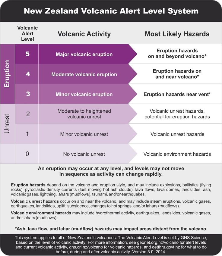
TABLES AND FIGURES:

TABLE 1. RUAPEHU UNREST TRIGGERS AND MANAGEMENT ACTIONS................................................... 18
TABLE 2. VOLCANIC UNREST ACTIONS FOR TONGARIRO ALPINE CROSSING AND NORTHERN CIRCUIT
    ....................................................................................................................................................... 23
TABLE 3. BREAKDOWN OF CIMS FUNCTIONS AND RESPONSIBILITIES ................................................. 26
TABLE 4. RUAPEHU ERUPTION TRIGGERS AND MANAGEMENT ACTIONS .............................................. 28
TABLE 5. VOLCANIC ERUPTION AND DE-ESCALATION ACTIONS FOR TONGARIRO ALPINE CROSSING
    AND NORTHERN CIRCUIT.............................................................................................................. 29
TABLE 6. VOLCANIC PHENOMENA INSIDE TONGARIRO NATIONAL PARK FROM TONGARIRO,
    NGĀURUHOE OR RUAPEHU ........................................................................................................... 34
TABLE 7. RUAPEHU VOLCANIC ACTIVITY SCENARIO ............................................................................. 36
TABLE 8. RUAPEHU LANDSLIDE SCENARIOS .......................................................................................... 36
TABLE 9. TONGARIRO ACTIVITY SCENARIOS ......................................................................................... 37
TABLE 10. NGĀURUHOE VOLCANIC ACTIVITY SCENARIO ..................................................................... 38
TABLE 11. PERFORMANCE MONITORING AND MEASURES – SEE 280745 ................................................ 40
TABLE 12. SUMMARY OF READINESS AND RESPONSE ACTIONS FOR WHAKAPAPA SKI FIELD AND
    WHAKAPAPA VILLAGE STAKEHOLDER COORDINATION AND INTEGRATION AT DIFFERENT
    VOLCANIC ALERT LEVELS ............................................................................................................. 42

FIGURE 1. VOLCANIC RISK MANAGEMENT APPROACH WITHIN TONGARIRO NATIONAL PARK .............. 6
FIGURE 2. NEW ZEALAND VOLCANIC ALERT LEVEL SYSTEM ................................................................. 8
FIGURE 3. VOLCANIC ALERT NETWORK CONCEPT FOR INTEGRATION OF VOLCANIC WARNING SYSTEM
    IN TONGARIRO NATIONAL PARK .................................................................................................. 10
FIGURE 4. DECISION TREE FOR TONGARIRO ALPINE CROSSING AND DOC MANAGERS AND ADVISORS
    ....................................................................................................................................................... 22
FIGURE 5. DOC'S RESPONSE STRUCTURE FOR MANAGING VOLCANIC ERUPTIONS AND EVENTS ............. 26
FIGURE 6. VOLCANIC HAZARDS AT TŪROA SKI FIELD .......................................................................... 32
FIGURE 7. VOLCANIC HAZARDS AT WHAKAPAPA SKI FIELD ................................................................. 33

Live Version – Guidelines for DOC Volcanic Risk Management in Tongariro National Park.
Updated July 2020. DOC-1130183
                                                                                                                                            Page 4 of 44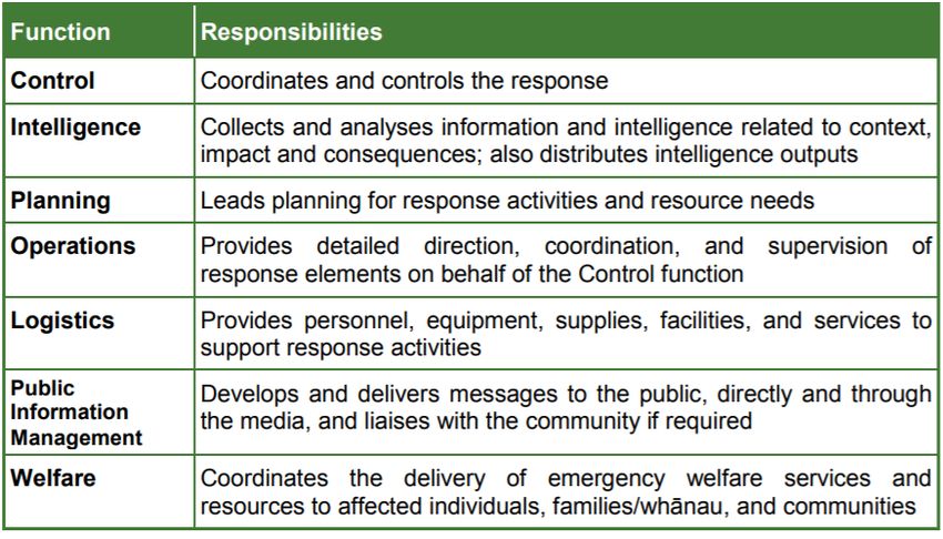
1. INTRODUCTION AND PURPOSE OF THESE GUIDELINES

These guidelines outline how the Department of Conservation (DOC) manages volcanic risk
within Tongariro National Park (TNP). This includes during quiet periods, volcanic unrest, non-
eruptive events, eruptions of Ruapehu, Tongariro and Ngāuruhoe volcanoes and de-escalation of
volcanic activity. It endeavours to outline the coordination with GNS, police, iwi and other agencies
as well as key management actions in relation to the escalation of volcanic activity. This document
remains live and will continue to evolve in response to emerging research relevant to decision-
making, unrest and future eruption lessons. The guidelines also outline closure decisions in
response to significant risk from unrest, volcanic events or eruptions but do not outline a plan for
reopening. The reopening phase will be planned and addressed alongside our treaty partners and
GNS.

This document is but one function of the overall approach to volcanic risk management within
Tongariro National Park by the Department. The approach has been split into systems and
processes to simplify and orientate users into the structure of volcanic risk management.

The Initial Response Plan (IRP) is the primary document that guides DOC’s initial response to an
eruption within Tongariro National Park, or a false positive activation of the Volcanic Alert
Network.

The documentation of DOC’s volcanic warning systems ‘the Volcanic Alert Network in TNP’
provides a detailed overview of the components of the Volcanic Alert Network (VAN) – their
history, purpose, how they work, roles and responsibilities, relationships with GeoNet and GNS
Science, testing, maintenance and other operational matters.

Live Version – Guidelines for DOC Volcanic Risk Management in Tongariro National Park.
Updated July 2020. DOC-1130183
                                                                                         Page 5 of 44
Figure 1. Volcanic risk management approach within Tongariro National Park

For further breakdown of the VAN, see Figure 3.

Live Version – Guidelines for DOC Volcanic Risk Management in Tongariro National Park.
Updated July 2020. DOC-1130183
                                                                                         Page 6 of 44
2. VOLCANIC PHENOMENA AND RISKS IN TONGARIRO NATIONAL PARK
2.1      Background
Ruapehu, Tongariro and Ngāuruhoe are active volcanoes. Records of their most recent eruptions
over the last 120+ years, complemented with research by many science agencies, indicate the most
likely range and extent of most volcanic phenomena that may occur during eruptions. Records
from the most violent eruptions in the last 10,000-15,000+ years indicate the maximum severity of
what might occur, or other vents that might become active (e.g. Pardo et al 2012).

The mountains erupt at irregular intervals, with warning of days to weeks or more and sometimes,
little to-no warning at all. The last major eruptions from Ruapehu occurred in 1995-1996 and a
typical short-lived event in September 2007. Much of our internal planning and preparation for
volcanic events predominantly focuses on one-offs or short-lived events. Emerging research from
Massey University and University of Auckland is focused revealing historical multi-phase and
long-term eruptions to ascertain eruption duration and scale. The last major eruptions at
Ngāuruhoe were in 1974/1975 with a small event in 1977. Tongariro erupted at Te Maari in August
and November 2012.

The main threats from volcanic phenomena are posed by the following:

    •   flying rocks (ballistics),
    •   Lahars, or volcanic mud flows,
    •   Pyroclastic density currents (PDCs); and
    •   Ash fall and gas – but these are generally a minor concern in comparison to those outlined
        above.

At Ruapehu, lahars are the more likely to injure people and damage property in comparison with
other volcanic phenomena, although flying rocks and blasts can still be fatal. Lahar paths exist
throughout the park, but in relation to proximity of visitors; lahars through the Whakapapa Ski
Field and Whakapapa Village are the most significant risk.

The time for a lahar to reach the top of the Whakapapa Ski Field from Te Wai ā-moe is
approximately 1-5 minutes, the bottom of the Whakapapa Ski Area 15 minutes, and Whakapapa
Village 25 minutes. Larger lahars travel faster, especially after heavy rain.

The recent 2012 eruptions at Te Maari damaged sections of the Tongariro Alpine Crossing with
ballistics (and inundated the now removed Ketetahi Hut) and produced a heat blast warm enough
to damage a significant amount of vegetation on the northern flanks west of Te Maari. These recent
and historical events are reminders of the variability and extent of volcanic phenomena present
within TNP.

Refer to Appendix B for further information on volcanic phenomena, volcanic activity, scenarios
and a summary of volcanic risks.

2.2     Volcano monitoring, Volcanic Alert Levels (VALs) and Bulletins (VABs)
All volcanoes within the TNP are constantly monitored by GNS through GeoNet. When a change
in volcanic unrest or activity is detected, various pre-determined actions are undertaken to reduce
the risk to people. For DOC this may include closing part of the Ski Fields on Ruapehu or closing
the Tongariro Alpine Crossing on Tongariro.

Live Version – Guidelines for DOC Volcanic Risk Management in Tongariro National Park.
Updated July 2020. DOC-1130183
                                                                                         Page 7 of 44
Figure 2. below describes the Volcanic Alert Levels that are applied to all volcanoes within New
Zealand. These levels are set by GNS and are a necessary and valuable guide in providing the
current volcanic unrest, or eruptive status of volcanoes. Their limitation is that they do not provide
for current or future scenarios or even predictions, these may be outlined within Volcanic Alert
Bulletins.
GeoNet: www.geonet.org.nz
GNS website: www.gns.cri.nz
Figure 2. New Zealand Volcanic Alert Level System
3. OVERVIEW OF APPROACH TO VOLCANIC RISK MANAGEMENT
Tongariro National Park contains three active volcanoes including four main vents (Ruapehu,
Ngāuruhoe, Te Maari and Red Crater) that have erupted producing severe volcanic phenomena
historically. Many visitors to the Park may be at risk in a sudden eruption or escalation of volcanic
activity if they are within the Hazard Zones and known areas of volcanic risk such as lahar paths.
3.1 Volcanic risk mitigation
DOC have based the volcanic risk mitigation system for the TNP on the 4Rs of Civil Defence
Emergency Management which are outlined below:
• Reduction: Identifying and analysing long-term risks to human life and property from
natural events; taking steps to eliminate these risks if practicable, and, if not, reducing the
magnitude of their impact and the likelihood of it occurring.
Live Version – Guidelines for DOC Volcanic Risk Management in Tongariro National Park.
Updated July 2020. DOC-1130183
Page 8 of 44• Readiness: Developing operational systems and capabilities before a civil defence
emergency happens; including self-help and response programmes for the general public,
and specific programmes for emergency services, lifeline utilities and other agencies.
• Response: Actions taken immediately before, during or directly after a civil defence
emergency to save lives and protect property, and to help communities recover.
• Recovery: The coordinated efforts and processes to bring about the immediate, medium-
term and long-term holistic regeneration of a community following a civil defence
emergency.
The main reduction tools include GeoNet and the VAN. The Earthquake Commission own GeoNet
but operational and maintenance responsibility lies with GNS. With respect to the TNP, GeoNet
works alongside the VAN and provides alerts to GNS in the event of seismic and eruptive events
associated with volcanic eruption or subsurface processes. There are various seismic monitoring
sensors throughout the TNP that communicate data to GNS, however, it does not always provide
automatic warnings to GNS as event magnitudes may be too small.
The VAN is the other key part of the risk reduction. These systems provide early warning of
eruption activity from any of the three volcanoes including the threat of lahar down paths on the
north-western, eastern flanks of Ruapehu. The warnings are received by a mixture of mediums
including automated pager, text and/or email to DOC and key agencies. Sirens located at the
Whakapapa Ski Field and Whakapapa Village are also activated as part of this system (tied
primarily to REDS). In addition to the four components of the VAN, electronic light signs are used
to indicate significant unrest at Tongariro, and ultimately may be deployed in conjunction with
closure of the Tongariro Alpine Crossing and Northern Circuit.
The readiness component is tied to our operational capability:
• VAN is operational and regularly tested
• Tongariro District duty staff (Response Rangers and Volcanic Rangers) are trained in
response procedures; and
• All appropriate documentation is up to date.
Readiness now recognises there are various ways volcanic activity can escalate and is addressed
by automatic monitoring, manual testing, active response to system faults, conducting eruption
exercises, staff rostering and ensuring training and plans are up to date.
The response component focuses on how DOC will function in response to an event. This will
involve DOC executing plans and management actions in conjunction with and alongside other
agencies. The recovery phase for DOC in response to volcanic events is dependent on the nature
of the volcanic event, the timeframe of de-escalation of activity and the impacts resulting from the
event. This will remain a case-by-case basis.
Live Version – Guidelines for DOC Volcanic Risk Management in Tongariro National Park.
Updated July 2020. DOC-1130183
Page 9 of 44GeoNet Tongariro
National Park
Ruapehu Eruption
Eastern Ruapehu Lahar Tongariro & Ngāuruhoe
Detection System Webcams, additional
Alert & Warning System Eruption Detection System
(REDS) monitoring etc
(ERLAWS) (TEDS)
Whakapapa Ski Area Lahar Whakapapa Village Lahar Tongariro Alpine Crossing
Geophones & Genesis
Alert & Warning System Alert & Warning System Monitoring: gas and wind electronic light signs at two
Tokaanu (and stream)
in conjunction with GNS car parks (installed only
(WLAWS) (VLAWS) monitoring sites
when required)
Horizons & TASC cams etc
Figure 3. Volcanic Alert Network concept for integration of volcanic warning system in Tongariro National Park
Live Version – Guidelines for DOC Volcanic Risk Management in Tongariro National Park.
Updated July 2020. DOC-1130183
Page 10 of 443.2 Summary of how volcanic risks are managed in Tongariro National Park
The volcanic risk mitigation system and management at TNP can be summarised under 10
categories:
1. Land use as a national park including the TNP Management Plan, policies, legislated
controls, concession management and volcanic maps.
2. Infrastructure is located away from at risk areas or designed appropriately for the
environmental conditions. Alternatively, if located in areas of risk appropriate mitigation
measures are in place to address ongoing volcanic risk.
3. Operational practice including Health and Safety policy and procedures when
conducting work in the field.
4. Volcanic monitoring by the GeoNet geological hazard monitoring system and research
by GNS, universities and others.
5. Alerted of changing volcanic conditions through Volcanic Alert Levels and Volcanic
Alert Bulletins by GNS and responding accordingly.
6. Communication to decision-makers, duty staff, treaty partners and appropriate agencies
when volcanic risk changes.
7. Management decisions and procedures, including advisories or temporary closure of
facilities and ensuring that the 4Rs are sufficiently covered.
8. Public awareness work to ensure visitors have full access to volcanic risk information and
are informed of changing volcanic conditions when risk changes.
9. The Volcanic Alert Network utilising sensor networks (including GeoNet) provide direct
warning of VAN activation almost instantaneously to staff, stakeholders via text/email or
page. Built in speakers sound a siren and voice message within the Whakapapa Ski Field
and Whakapapa Village.
10. Response plans including interagency coordination and training. The Senior Ranger
Public Safety and Technical Advisor Volcanology are responsible for training on
response plans/actions.
Whilst the Department has made significant attempts to reduce the risk to visitors within the Park
from volcanic activity, we recognise that some residual risk to visitors will always remain due to
people’s behaviour, their proximity to vents and practical constraints on warning systems within
areas of volcanic risk.
3.3 DOC staff and visitor safety roles
Overview
DOC’s Visitor Risk Management Policy, SOP and Guidelines outline the organisation’s overall
responsibility and approach to visitor safety (more specific volcanic risk management obligations
within DOC-3136467). During volcanic unrest and eruptions, the Department’s role will be to
address the safety of visitors, concessionaires and staff within TNP. The primary and most effective
means of managing volcanic risk is to close at risk destinations within TNP – prior to eruptions
occurring. DOC uses volcanic alert levels and other information about volcanic unrest from GNS
to make these management decisions.
In response to eruptions (usually triggered by VAN activations) our role is informing managers,
activating supporting staff as necessary, making decisions about facility closures and any
immediate response needs in collaboration with Police. In an emergency response context, Police
are the main agency with statutory responsibility for public safety in NZ. Within the boundaries of
the park, it is DOC’s role to assist them.
Live Version – Guidelines for DOC Volcanic Risk Management in Tongariro National Park.
Updated July 2020. DOC-1130183
Page 11 of 44The IRP phone callout will notify treaty partners, concessionaires and key agencies of an event.
The Minister of Conservation and other senior management will need to be advised as soon as
practical, and this responsibility will sit with the CNI Director Operations or be initiated by the
Tongariro Operations Manager in the director’s absence. Other management decisions and actions
to further address visitor, concessionaire and staff safety will take place in the ensuing period.
As a Person Conducting Business or Undertaking (PCBU) DOC has a legal role regarding staff and
concessionaire safety. DOC has a duty to share information about hazards and risk management
with concessionaires and staff. Concessionaires – particularly guides and registered adventure
activity operators have responsibility for the safety of their customers.
Staff Safety
Staff safety is paramount and will be managed by communicating heightened volcanic risk and
risk mitigation options to staff who are working in at risk areas such as Hut Rangers and Tongariro
Alpine Crossing Rangers during the Great Walk Season. Again, the most effective risk mitigation
option is to eliminate exposure by closing areas prior to eruption (if possible).
Staff health and safety management controls are detailed in the Safety Plan for the Tongariro
District Operations Team – see Risk Manager. These hazards are updated annually in Risk
Manager or as required, considering the volcanic risk present, hazard type and likelihood of
occurrence.
A Job Safety Analysis (JSA) is always conducted before any fieldwork is conducted.
Visitor Safety
The severity of risk to visitors depends on the following factors:
• Location of people in relation to the volcanoes
• Proximity of people in areas of high risk
• Probability and severity of volcanic phenomena
• Length of time people are exposed to them
• Their ability to move out of harm’s way.
Risks are highest within the Hazard Zones around active or recent vents, and subsequently in paths
of lahar or pyroclastic density currents, and along the Tongariro Alpine Crossing. Huts and other
tracks in TNP around the volcanoes are at lesser risk unless eruption magnitude increases. Posters
outlining typical volcanic phenomena impacts and spread for both Tūroa and Whakapapa Ski
Areas’ are in Appendix B.
Despite closures being the most effective mitigation option, volcanic activity is often
unpredictable. DOC’s ability to manage the exposure of visitors to volcanic risk can be limited –
especially since the volcanoes are one of the main attractions in TNP. Decisions about access
should always rely on good information, especially from GNS regarding the status of the volcanoes.
Risk assessments are part of decision-making and such information is necessary but may never be
enough.
DOC recognises that visitors are generally responsible for their own safety within TNP, especially
when entering areas such the Hazard Zones. However, DOC must provide quality pre-visit and on-
site information, so visitors are able to make informed decisions on the level of risk they are taking.
Live Version – Guidelines for DOC Volcanic Risk Management in Tongariro National Park.
Updated July 2020. DOC-1130183
Page 12 of 443.4 DOC’s core partners, stakeholders and science/research and emergency management
organisations
DOC’s core partners in management of volcanic activity in TNP:
• Ngāti Tūwharetoa, Ngāti Hikairo and other associated hapū.
• Ngāti Rangi.
• Uenuku.
• Other iwi of the Kāhui Maunga who may wish to be involved.
• GNS.
• Police.
Stakeholders impacted by volcanic activity in, or from TNP:
• Ruapehu Alpine Lifts.
• Tūkino Alpine Sports Club.
• Tongariro Alpine Crossing Transport and Guides group (TACTAG).
• Other concessionaires in TNP.
• Genesis Energy, NZ Army, Transpower and KiwiRail.
• Ruapehu Mountain Clubs Association, Iwikau and Whakapapa Village communities.
Science/research and emergency management organisations:
• CDEM agencies including Taupō and Ruapehu district councils with CPVAG having a
coordinating role during non-eruptive periods.
• Universities and other science/research agencies.
3.5 Coordination with GNS, Police and CDEM
GNS Science
GNS is responsible for monitoring volcanic activity, setting Volcanic Alert Levels and issuing
Volcanic Alert Bulletins. As such they are an indispensable agency and DOC must maintain close
communications with them during volcanic unrest, emergencies, in periods following eruptions
and during quiet times. DOC and GNS have an important and well-tested Memorandum of
Understanding (DOC and GNS now have a national Multi-Service Agreement, and our current
local MOU needs to be updated) which details the relationship further including cooperation
regarding working with the media.
In relation to volcanic risk management actions, DOC should inform, discuss and seek input on
major decisions or external communications with GNS. GNS would usually advise us when a
Volcanic Alert Bulletin is being developed and released, but time constrains may limit this.
Police and CDEM
This document recognises the NZ police’s statutory role regarding public safety during an
eruption. More recently the roles and responsibilities of all agencies, including DOC’s fundamental
role within the park, have been outlined within the Tongariro Volcanic Centre Contingency Plan.
Outside the park, councils and other CDEM agencies have the statutory role and DOC will assist
as much as possible.
DOC maintain their decision-making role within the park in all cases, however if an Emergency
Declaration is made, CDEM agencies will take over the decision-making role. Declaration criteria
and dependent scales for this decision needs to be clearer, and DOC should have input into this.
Criteria such as Volcanic Alert Levels should be used in complementary ways by the various
agencies, to ensure a collective response and consistent messaging across all organisations is
Live Version – Guidelines for DOC Volcanic Risk Management in Tongariro National Park.
Updated July 2020. DOC-1130183
Page 13 of 44maintained and is consistent with the actual risk. A poorly perceived “perception of risk” should
not be the driver of response.
3.6 Communication plan
The communication plan has received a significant update that has refined and isolated the key
tasks required in response to changing volcanic unrest and initial response to eruptions. The
purpose of the document is to disseminate information that is critical to protecting the safety of
public and informing users of the changing volcanic conditions. The communication plan directs
the DOC specific response and recognises also the role and discussions required within the wider
CPVAG PIM context that is outlined within the Tongariro Volcanic Centre Contingency Plan.
3.7 Performance monitoring
DOC monitors volcanic risk management performance via KPIs, standards and measures, as
detailed within Appendix C.
4. VOLCANIC RISK MANAGEMENT METHODOLOGY
4.1 Introduction: slow escalation of volcanic activity
It is highly likely that activity or unrest will escalate slowly, over several days, weeks or more. It is
imperative that DOC works alongside GNS, police, treaty partners and local councils and their
procedures. Maintaining and involving our treaty partners in discussions and key decisions
relating to this slow escalation for all maunga is also important. The other agencies have actions
that are also coordinated by CPVAG and summarised in the Contingency Plan (2018). Many of the
roles DOC has and actions needed to be taken within TNP will be the same as for rapid escalation.
However, outside TNP the other agencies will have time to carry out their normal roles regarding
public safety and emergency management.
4.2 Decision-making information during volcanic unrest
As well as basic considerations about weather conditions, time of day and location of staff, the
advice for management decisions should be based on the following scientific data and advice
during escalation of volcanic unrest or activity:
1. Volcanic Alert Level increase from 0 to 1 or 1 to 2. This and other information are distributed
via Volcano Alert Bulletins or available directly from the GNS Duty Volcanologist and
www.geonet.org.nz
2. When Volcanic Alert Level is at 2 but not quite 3 (based on discussions with and advice
from GNS) some considerations to be aware of:
• Increased concerns based on monitored GeoNet parameters such as seismic
magnitude increase, decreasing depth, increased gas flux, changing chemistry of
fluids, increased deformation.
• Visual evidence obtained from monitoring of field observations or forecasts that raise
concern. Some examples are local small-scale eruptive activity, debris or ash
accumulations, secondary events such as impounded water, forecasts of heavy rain,
wind direction, changing levels of Te Wai ā-moe or other lakes involved.
• With rapid escalation of unrest DOC may need to act independently from
CDEM/CPVAG and perhaps even Police and GNS. However, with a slow escalation
DOC should work in association with group decision-making as far as possible.
Live Version – Guidelines for DOC Volcanic Risk Management in Tongariro National Park.
Updated July 2020. DOC-1130183
Page 14 of 443. Indicators of potential increase of risk such as modes of cool or hot temperatures, levels of
lakes or other situations described earlier.
4.3 General DOC management actions during volcanic unrest
The range of management actions during escalation of activity in order of increasing need for rapid
action in response to increased risk is as follows, but not necessarily in this order:
1. Communication with supervisors in relation to staff in the field and with Hut Ranger
Coordinator for additional information, but also to provide instructions to them if required.
2. Prepare a skeleton crew CIMS structure in preparation for an eruption, with closer
collaboration with GNS, police and iwi.
3. Temporary closure of one or more DOC huts that may be at higher risk from an eruption.
4. Restrictions or closures of tracks and/or facilities near the unrest site and at-risk zones. This
may require the additional checking of tracks and the erection of signs.
5. If electronic lights signs deployed on the Tongariro Alpine Crossing, changing colour of
lights may be required.
6. Closures of Bruce, Mountain, Tūkino, Ketetahi, Mangatepōpō and other roads in or near
the park with police support in the emergency phase and councils/CDEM outside TNP as
long-term management gets underway.
7. Gain situational awareness (if it is considered safe to do so) to gain further understanding
of volcanic activity. Helicopters that may be requested for use are listed on DOC’s National
helicopter service directory.
8. More specific discussion and liaison with treaty partners and development of joint actions
including volcanic risk management and mitigation measures.
9. Ministerial briefings as regularly as required.
10. DOC media releases as per Communications Plan integrated with or immediately
following GNS Volcanic Alert Bulletins or other agency media releases with specific
messages as required. If time permits, drafts of these releases should be sent iwi and
appropriate agencies during the draft phase prior to release.
11. Engagement with media to assist them in carrying out their roles (where this does not
conflict with other management).
12. Further monitoring of specific volcanic phenomena such as areas of potential lahar paths
where secondary volcanic events may occur (e.g. debris dammed lakes or thick ash
deposits).
13. Support for GNS and other science agencies monitoring a vent(s) before or after eruptions.
14. Revision of existing risk assessments and response plans or preparation of new ones.
15. Considerations for the development of a recovery plan to pre-empt post eruption phase
which could include emergency funding and staffing, track repairs, safety plans,
development of additional mitigation tools and advocacy (e.g. Site-specific safety plan for
eruption repair work on the TAC DOC-1091466).
There are various other specific tasks that might be needed, but which are not DOC’s primary
responsibility. DOC would usually respond with all resources necessary in support of or in
conjunction with the police and other agencies. These tasks could include SAR, emergency care,
disaster control, law enforcement.
4.4 Managing Ruapehu volcanic unrest
Ruapehu predominantly sits at a VAL 1 which is indicative of its constant state of minor unrest
conditions present and the consistent monitoring of volcanic activity. For the majority of time VAL
1 status is maintained, however there have been two instances since the eruption in September
2007 where this changed. Ruapehu moved from VAL 1 to VAL 2 from May – July 2016 due to a
combination of elevated unrest conditions consisting of higher temperature at Te Wai ā-moe,
Live Version – Guidelines for DOC Volcanic Risk Management in Tongariro National Park.
Updated July 2020. DOC-1130183
Page 15 of 44increased and changing volcanic gas emissions, changing water chemistry and elevated levels of
tremor. The rise and fall of these unrest conditions usually go hand in hand with the periodic
temperature cycle at Te Wai ā-moe. In some instances, elevated temperatures at Te Wai ā-moe,
such as the hot lake mode (as described below) does not always constitute a change in VAL if other
unrest conditions are not similarly elevated. For the most part, higher parameters of unrest
conditions do not usually result in an eruption.
GNS monitor various conditions at Ruapehu, with real time short-term or long-term trends of
temperature at Te Wai ā-moe, seismicity and monthly gas and water chemistry sampling which are
completed manually by GNS.
Te Wai ā-moe temperature modes and lake levels
Te Wai ā-moe reflects magmatic heating and vent conditions through lake temperature, water
chemistry and gas outputs. The short-term and long-term temperature trends maintained by
GeoNet (available to the public) are indicative of the expected ranges at Te Wai ā-moe. While these
higher and lower temperature cycles are commonplace at Te Wai ā-moe, they suggest the level of
heat input or lack of below the lake, and in the absence of other monitoring data such as changes
in seismicity, gas or water chemistry which are held by GeoNet, these temperature ranges serve as
prompts for discussion both internally at a district level and with GNS. Whilst higher temperatures
can be accompanied by water chemistry changes, increased and sometimes changing gas
emissions, increase in tremor; it signals to us an open vent. On the contrary the cooler temperature
range can often mean the absence of observed changes potentially due to reduced heat through
the vent, or less often caused through a sulfur seal over the vent blocking heat from the system
below.
Therefore; two indicative temperature modes have been defined by DOC:
Cool lake more:
• With lake temperature trending towards 17.5°C, conduct discussions with GNS on likely
temperature trend and wider vent conditions to ascertain if further unrest indicators are
present, or not.
• Be mindful of the presence or absence of intermittent upwellings or sulphur slicks during
these cooler temperatures as they indicate an open vent 15°C or lower discussions to
continue to ascertain if eruption probability has changed – see Table 1 for decision modes
and actions.
Hot lake mode:
• Temperatures trending towards and going above 40°C should include heightened
monitoring as above and ongoing discussions with GNS to understand other vent
conditions and unrest parameters.
Refilling lake mode:
• Close monitoring of rising lake level towards or above previous levels required for risk
management purposes. Establishing warning levels and management decisions in
response to lake level will be required.
• Warning levels and management decisions based on 1997-2007 are documented in docCM-
50552, Keys and Green 2008 and further preparation, collaboration and response to
situations like 1997-2007 will need to be developed and implemented.
Live Version – Guidelines for DOC Volcanic Risk Management in Tongariro National Park.
Updated July 2020. DOC-1130183
Page 16 of 44There may be other indicators of enhanced risk, due to other evidence or types of instability on the
volcanoes. The most recognised indicator are small rockfalls and larger landslides from the
volcanoes, these are also known as flank failures or sector collapses. Increased seepage from a lake
might also be apparent. Deformation may also be an indicator relating to instability – it could be
possible to detect situations before an event.
Therefore, a fourth mode of risk is identified:
Slope deformation mode:
• Indications of possible instability will be from changes in key landscape features (cracks)
or established benchmarks. Initial watch and management decisions in response to any
surface changes and advice, including monitoring survey benchmarks and/or cracks
documented for Ruapehu’s crater rim 1998-2011 by Energy Surveys 2011, west rim of Upper
Te Maari Crater or increased seepage from the Ruapehu tephra dam or Te Maari landslide
dam documented in Keys and Green 2008 and elsewhere and Jolly et al 2014, as well as the
stability of the Crater Rim (Schaefer et al, 2018).
Live Version – Guidelines for DOC Volcanic Risk Management in Tongariro National Park.
Updated July 2020. DOC-1130183
Page 17 of 44Table 1. Ruapehu unrest triggers and management actions
DOC Risk V Considerations and potential Management Tools Management Actions Timeline
Management A triggers from volcano and
Stage L GNS
A 1 Normal, including aperiodic
cycling of water temperatures
Recommendation to public not to •
enter the crater basin (700m
Ensure public recommendation
is in place and up-to-date
Normal cycle including
resumption of it.
at Te Wai ā-moe and radius from centre of Crater Lake), information is available via
resumption of this cycling. not to camp in the Summit regularly used mediums.
Plateau and to take care when
travelling in known lahar paths.
B 1 Increasing unrest but no VAL
change – situation not
Recommendation to public not to •
enter the Summit Plateau (1.5 km
Ensure public recommendation
is in place and up-to-date
Management actions and
messaging should be tailored to
entirely ‘normal’. radius from centre of Crater Lake) information is available via activity level and likelihood of
and to take care when travelling regularly used mediums VAL change.
Questions and uncertainty. in known lahar paths. • If Summit Plateau concessions
are suspended, ensure It could be that:
Could include any of, but not Suspension of concession concessionaires with permits to
limited to the following: activities within the 1.5km radius. undertake activities within this 1. Normal heating cycle is not
area are notified entirely present. Or:
• VAB released on elevated Communication with GNS on • Undertake initial risk
unrest, but may not be potentially elevated unrest assessment and prepare for 2. There is other anomalous
enough to change VAL parameters. Gauge likelihood of VAL 2 to be reached, activity and trending towards
• Increased tremor or VAL change. discussions on access, VAL change (situations at 10
earthquake activity concessions – address the what January 2013, 11 May 2016).
• Anomalous temperature Ensure Guidelines and IRP are up if?
trend – period of cool or hot to date and revisited by key staff • CNI Director, Ops Manager and The intensity of DOC’s response
temperatures. (Trending (Response Rangers/Volcanic PIM advised (current situation, should reflect which of these
well beyond 40°C or well Rangers/Ops Manager). concerns and likely scenarios) scenarios is being managed.
below 15°C) • Initial (email) communication
• Increased gas emissions to treaty partners, RAL,
ERLAWS stakeholders, Police
Live Version – Guidelines for DOC Volcanic Risk Management in Tongariro National Park.
Updated July 2020. DOC-1130183
Page 18 of 44• No gas emissions (vent (OC National Park, OC Taupō)
blocked?) on current activity
• Absence of upwelling • Initial (email) communication
(sulphur slicks) on Crater with CPVAG
Lake surface. • Considerations to release, share,
reiterate DOC key messages
alongside or soon after VAB –
PIM to draft and prepare
• REDS/WLAWS assurances
completed, consider daily tests,
and full test – address issues if
they arise
• Ensure Tongariro District staff
are informed, and VR
refamiliarized with key
response actions, review of
CIMS structures and
requirement
• Signs (held at ski areas)
deployed if trending toward
VAL change or risk warrants it.
C 2 VAB has been released and
VAL change has occurred.
Access to the 2km radius from
centre of Crater Lake is closed.
• CNI Director, Ops Manager and
PIM advised (current situation,
When unrest parameters are
more definitive.
Public are not to enter this area concerns and likely scenarios)
Additional or more significant and all concessions that operate • Advisory that 2km radius is
unrest parameters including within this area are suspended closed and public are not to
seismic activity (e.g. low until further notice. enter this area
frequency, EQ swarm • Ensure concessionaires with
magnitude/location/depth), If volcanic unrest continues to permits to undertake activities
ground deformation, anomalous escalate, and eruption probability within this area are notified of
lake level/discharge changes or increases, consider extending the this advisory
chemistry, or other anomalous closure to the entire Summit • Signs (held at ski areas)
Hazard Zone (3km radius from deployed
Live Version – Guidelines for DOC Volcanic Risk Management in Tongariro National Park.
Updated July 2020. DOC-1130183
Page 19 of 44activity more directly related to centre of Crater Lake) and • Organise hui with treaty
likely volcanic activity. suspending all concessions that partners, RAL, Police (OC
operate within this area until National Park, OC Taupō), RDC
further notice. and TDC on situation around
access, closures, concessions
Maintain regular contact and and risk analysis and eruption
communication with GNS Team preparation
Leader Volcanology. • Conversation with CPVAG on
outcomes above and likely way
forward
• Conversations with ERLAWS
stakeholders on situation
• PIM to execute information
release and action outcomes
• Daily EDS testing ERLAWS
systems check
• Risk Assessment review
• DLT/VR hui held, discussion on
IMT roles and responsibilities
in preparation for further
escalation.
Live Version – Guidelines for DOC Volcanic Risk Management in Tongariro National Park.
Updated July 2020. DOC-1130183
Page 20 of 444.5 Managing Tongariro volcanic unrest
Unlike Te Wai ā-moe (Crater Lake) – the current singular source of eruption at Ruapehu, there are
multiple vents across the Tongariro Complex that volcanic activity and eruptions could originate
from. This adds complexity to the management of unrest – especially when the Summer/Great
Walk season brings major foot traffic to the Hazard Zones of Ngāuruhoe, Red Crater and Te Maari1.
Both the Tongariro Alpine Crossing and Tongariro Northern Circuit traverse Red Crater and
Emerald Lakes. The proximity of visitors to these potential eruption sources is a significant
consideration when access decisions are made during periods of unrest.
It is critical that DOC is highly responsive to any changes in volcanic activity on Tongariro and
has clear management actions to mitigate increasing risk when unrest occurs.
1 These are the three vents referred to in Figure 4.
Live Version – Guidelines for DOC Volcanic Risk Management in Tongariro National Park.
Updated July 2020. DOC-1130183
Page 21 of 44Figure 4. Decision tree for Tongariro Alpine Crossing and DOC managers and advisors 2
2 Requires review once Risk Tolerance Thresholds are established.
Live Version – Guidelines for DOC Volcanic Risk Management in Tongariro National Park.
Updated July 2020. DOC-1130183
Page 22 of 44Table 2. Volcanic unrest actions for Tongariro Alpine Crossing and Northern Circuit
Partner/stakeholder VAL 0 but GNS or VAL 1 VAL 2
communication and VAB report some
DOC management possible signs of DOC Risk Management Stage B DOC Risk Management Stage C
tools unrest
DOC Risk
Management Stage A
Treaty partners Discuss with senior Ensure Ngāti Hikairo and other treaty partners are Ensure treaty partners are kept informed and remain
contacts in Ngāti informed, possibly at a hui at a local marae and involved.
Hikairo. discuss possible scenarios and management actions.
GNS Science Initial communication • Maintain regular communication with GNS Initiate or participate in scenario planning and
and requests. • Ensure monitoring and review of data is shared coordinate community meeting(s).
with DOC
• Urgently facilitate any requests for additional
deployment of extra monitoring equipment etc.
DOC management Key staff to familiarise • Update to CNI Director, Ops Manager and PIM • Update to CNI Director, Ops Manager and PIM
actions with Initial Response (current situation, concerns and likely scenarios) (current situation, concerns and likely scenarios)
Plan and the Guidelines • Share VAB/VAL change with treaty partners, • Share VAB/VAL change with treaty partners, Police
documents. Police (OC National Park, OC Taupō) initially, (OC National Park, OC Taupō)
follow up with need for hui alongside RDC/TDC • Send email out to key stakeholders attached to phone
CNI Director, Ops and GNS call out with information – direct them to updates
Manager and PIM • Communication to key stakeholders outlined in provided by PIM
advised (current phone call out for Tongariro • Hui with treaty partners, Police (OC National Park,
situation, concerns, and • Regular communication with GNS OC Taupō), RDC/TDC and GNS relating to DOC
likely scenarios). • Risk assessment development and request data actions
from GNS – in relation to ongoing closure. • Scenario planning commenced and additional
response actions identified
• Regular communication with GNS.
Live Version – Guidelines for DOC Volcanic Risk Management in Tongariro National Park.
Updated July 2020. DOC-1130183
Page 23 of 44TAV and SR-PS to support the Ops manager in the TAV and SR-PS to support the Ops Manager in the
following: following:
• Decision on closure of the Tongariro Alpine • Incident Control Point planning and IMT roles
Crossing and sections of the Tongariro Northern established, considerations for a roster for key roles
Circuit if unrest is located at one of the three may be required
main vents; Ngāuruhoe, Te Maari or Red Crater • Police & helicopter pilots advised and put on standby
• Preparations for hut, track and road closures with as necessary
barriers & signage as necessary • Field staff procedures for locations at risk and work
• Meeting with RR/VR/DLT and note IMT prioritisation
discussion and preparation • Meeting with VRs and note IMT discussion and
• Meeting with DLT to support development of preparation.
procedures for field staff – locations and work
prioritisation.
Electronic light Prepare light signs and Based on access decision above – light signs Lights remain red – track closed.
signs locations for deployed at both track ends showing red – track
deployment. closed.
Media & Ops Manager and CNI Comms plan initiated. Comms plan initiated and developed with other agencies
communication plan Director advised of Consider development in conjunction with other involved including treaty partners, police, GNS,
situation. agencies including treaty partners, police, GNS. TACTAG etc.
Minister and DOC Wellington Office informed, and
briefings/decision documents prepared as necessary.
Preparation for follow up releases at predetermined
timeframe or as new information becomes available.
TACTAG Contact made with Meeting held with TACTAG members, possibly in TACTAG members invited to meeting supported by
Chair or Secretary and conjunction with a wider meeting, to outline GNS.
preliminary plans made situation and discuss possible scenarios and actions.
for discussions with
whole group.
Live Version – Guidelines for DOC Volcanic Risk Management in Tongariro National Park.
Updated July 2020. DOC-1130183
Page 24 of 444.6 Summary of stakeholder coordination and integration during unrest
Table 12. in Appendix C contains a summary of Whakapapa stakeholder coordination and
integration during unrest and eruption.
5. MANAGING VOLCANIC ERUPTION AND DE-ESCALATION OF VOLCANIC ACTIVITY
5.1 Rapid escalation of volcanic activity
The Initial Response Plan (IRP) is to be used in response to sudden volcanic activity within the
TNP. Response Rangers will follow the appropriate procedures outlined within this document to
firstly, confirm event with GNS Duty Volcanologist, secondly follow instruction from Volcanic
Ranger to alert and/or confirm an event to stakeholders alerted by the Volcanic Alert Network.
All reflex actions and key tasks are outlined within the IRP and the Response Rangers and Volcanic
Rangers should be well versed with these procedures. It is important for DOC to understand the
status, scale and location of the event to then execute the appropriate tasks. For large eruptions,
DOC may need to initiate a CIMS working with and alongside the wider DOC team, and other
agencies. Incident Action Plans from 2012 Te Maari have been prepared to respond to such as event
DOC-1279700.
Understanding the nature of historical events can help assist planning and preparations for future
eruptions. Large magmatic eruptions such as the 1945, 1995-96 eruptions of Ruapehu deposited a
significant amount of volcanic material on the crater rim which enabled a higher volume of water
to be contained within the lake. The eventual collapse of the crater lake rim caused two large lahars;
1953 which resulted in the deaths of 151 passengers and in 2007 with no injuries or death.
Alternatively, a lake may be created by a debris avalanche such as happened during the 2012
eruption episode of Te Maari.
5.2 Initial Response Plan
As described above, the IRP is the fundamental response document for any volcanic events (or a
false positive activation of the VAN). It contains initial reflex tasks and the phone callout to key
stakeholders within the first hour of an activation of the following components of the VAN which
are all located within the Park:
• Ruapehu Eruption Detection System (REDS) and Whakapapa Ski Area Lahar Alert and
Warning System (WLAWS),
• Whakapapa Village Lahar Alert and Warning System (VLAWS),
• Tongariro Eruption Detection System (TEDS),
• Eastern Ruapehu Lahar Alert and Warning System (ERLAWS).
The IRP is used to alert key agencies and stakeholders with interests in the TNP of a false positive
or real event. This document is primarily used by Volcanic Rangers, but during an event or ongoing
events, other staff may be tasked to execute the phone call out section. The Trello app (on Volcanic
Ranger phones) is a digital version of the callout lists.
The VAN is operated by DOC and GNS Science and has been developed over the last 30 years to
help mitigate volcanic risk from sudden eruptions. Following the 1969 and 1975 Ruapehu eruptions,
a Lahar Warning System was installed in 1983 at Whakapapa Ski Area and an extension in
Whakapapa Village was installed sometime after this.
Live Version – Guidelines for DOC Volcanic Risk Management in Tongariro National Park.
Updated July 2020. DOC-1130183
Page 25 of 44REDS and WLAWS have operated since 1999 and had a major upgrade in 2012. VLAWS was
remodelled in 2013. TEDS was commissioned in 2014 after the Te Maari eruptions and ERLAWS in
early 2001/02 to address the lahar risk after 1995-1996 eruption episodes.
When an activation of the VAN occurs, a series of automated messages (text page and email) is
sent to DOC duty staff and to affected stakeholders. For REDS and VLAWS, sirens and voice
messages are extra measures that are set off during activations.
The VAN is mostly self-monitored automatically and the individual systems are tested on various
predetermined time scales (every few seconds, daily, monthly, six monthly or yearly). Maintenance,
remedial and emergency work is carried out by the following companies who we have worked with
since 2001:
Communication Network Management Ltd (CNML), Rotorua
(WLAWS, VLAWS, ERLAWS, lights)
Field hardware engineer:
Cybernetics, Auckland (WLAWS, VLAWS, TEDS)
Control System (SCADA) engineer and technical support:
Tesla Ltd, Hamilton (ERLAWS)
Technical system support:
DOC Information Systems and Services (ERLAWS)
5.3 CIMS Structure in response to volcanic event
The standard CIMS structure will be applied by the Department in response to a volcanic event
to ensure effective and collaborative interagency response as described below in Fig. 5.
Figure 5. DOC's response structure for managing volcanic eruptions and events
The responsibilities of each function are described below for reference in Table 3.
Table 3. Breakdown of CIMS functions and responsibilities
Live Version – Guidelines for DOC Volcanic Risk Management in Tongariro National Park.
Updated July 2020. DOC-1130183
Page 26 of 44You can also read