Furneaux Fire Management Area - Fire Protection Plan 2014 2019
←
→
Page content transcription
If your browser does not render page correctly, please read the page content below
Furneaux Fire Management Area
     Fire Protection Plan
         2014 - 2019

                                1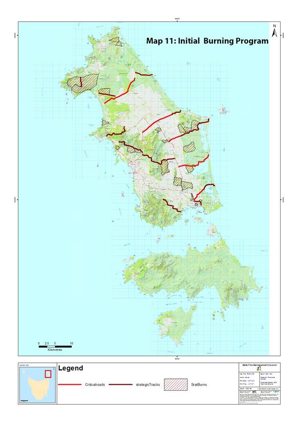
Document Control

Document History
Version                Date               Author      Section

1.0                                       S Summers   Draft
2.0                                                   Final

Document Endorsements
Agency                 Name & Title       Signature   Date
Raoul Harper           Flinders Council
Steve Lowe             TFS
Graham Gardiner        TALC
Jim Grace              TFS
Darren Grace           TFGA
Steve Summers          PWS
Nigel Binns            TAS Networks

Endorsed for Furneaux Fire management Area Committee

____________________________________

Chairman –
Date:

Accepted by State Fire Management Council

____________________________________

Chairman – Ian Sauer
Date: 13/1/15

                                                                2
Table of Contents
Document Control................................................................................................................................... 2
   Document History ............................................................................................................................... 2
   Document Endorsements ................................................................................................................... 2
   Endorsed for Furneaux Fire management Area Committee............................................................... 2
   Accepted by State Fire Management Council..................................................................................... 2
Glossary ................................................................................................................................................... 5
Acronyms ................................................................................................................................................ 7
Chapter 1          Introduction ........................................................................................................................ 8
   1.1         Background ............................................................................................................................. 8
   1.2         Aim and Objectives ................................................................................................................. 8
   1.3         Plan Context ............................................................................................................................ 8
   1.4         Policy, Standards and Legislation ............................................................................................ 9
       Standards ........................................................................................................................................ 9
       Legislation ....................................................................................................................................... 9
Chapter 2          Establishing the Context ................................................................................................... 10
   2.1         Description of the Furneaux Fire Protection Plan Area ........................................................ 10
       2.1.1 Location, Boundaries and Land Tenure ............................................................................... 10
       2.1.2 Climate and Bushfire Season ............................................................................................... 12
       2.1.3 Vegetation ............................................................................................................................ 12
       2.1.4 Population and Demographics ............................................................................................. 13
       2.1.5 Bushfire Frequency and Causes of Ignition.......................................................................... 14
Chapter 3          Analysing and Evaluating Bushfire Risk ............................................................................. 15
   3.1         Analysing Bushfire Risk ......................................................................................................... 15
   3.2         Likelihood .............................................................................................................................. 15
   3.3         Consequence (values at risk) ................................................................................................ 15
   3.4         Overall Risk............................................................................................................................ 16
   3.5         Risk Analysis for the Furneaux Fire Management Area ........................................................ 16
       3. 5.1          Community Assessment................................................................................................ 17
Chapter 4          Bushfire Risk Treatment .................................................................................................... 18
   4.1 Planning framework .................................................................................................................... 18
       4.1.1 Community risk management .............................................................................................. 18
   4.2         Region Wide Controls ........................................................................................................... 19
       4.2.1           Strategic fire infrastructure........................................................................................... 19
       4.2.2           Strategic Burning program ............................................................................................ 20

                                                                                                                                                            3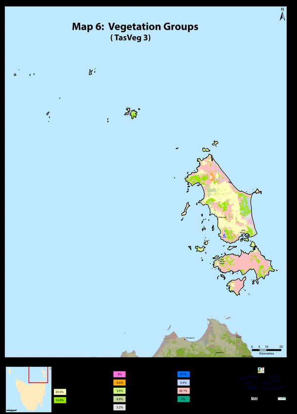
4.3         Asset Specific Treatment Strategies ..................................................................................... 21
   4.4         Treatment Selection and Priorities ....................................................................................... 21
   4.5         Implementation Program...................................................................................................... 22
   4.6         Implementation .................................................................................................................... 23
Chapter 5         Monitoring and Review ..................................................................................................... 23
   5.1         Review ................................................................................................................................... 23
   5.2         Monitoring ............................................................................................................................ 23
   5.3         Reporting............................................................................................................................... 24
References ............................................................................................................................................ 25
   Appendices........................................................................................................................................ 26
   Appendix 1 – Maps of FMAC area displaying context information .................................................. 26
   Appendix 2 - The Bush Fire Risk Model (BRAM) ............................................................................... 31
   Appendix 3 – NERAG risk assessment approach............................................................................... 37
   Appendix 4 – Bushfire Risk Assessment Maps .................................................................................. 40
   Appendix 5 – Community Specific Plans already in place................................................................. 43
   Appendix 6 – Implementation Strategy ............................................................................................ 44
   Appendix 7 - Strategic fire infrastructure and conceptual zoning .................................................... 49
   Appendix 8 - Strategic fuel management program........................................................................... 50
   Appendix 9 – Description of vegetation communities...................................................................... 51

                                                                                                                                                          4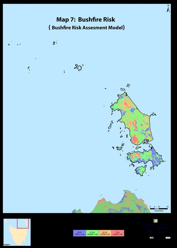
Glossary
Asset              A term used to describe anything valued by the community that may be
                   adversely impacted by bushfire. This may include residential houses,
                   infrastructure, agriculture, industry, environmental and heritage sites.

Asset Zone         The geographic location of asset(s) of high value or importance and the physical
                   boundary immediately around the asset.

Asset Protection   An area of high strategic importance to protect values in the asset zone. Regular
Zone               fuel reduction should be undertaken in the vicinity of specific assets. (Up to 1km
                   wide around the asset). The area within 1.05km of a human settlement area
                   (SFMC Fuel Strategy)

Strategic Fuel     Area of management that will increase the likelihood of controlling a bushfire
Management         within or the forward spread through the area. Located strategically in fuel
Zone               types of high or greater flammability. Fuel to be managed by prescribed
                   burning. Between 1.05km and 6.05km from a human settlement area (SFMC
                   Fuel Strategy)

                   An area that is managed to meet the objectives of the relevant land manager,
Land
                   which can be planned fire for fuel reduction, biodiversity conservation or forest
Management
                   regeneration.
Zone
                   Bushfire Risk Assessment Model – A computer based modelling tool that uses a
BRAM
                   series of inputs to assess the risk of bushfire to a specific area. The BRAM has a
                   capacity to produce a series of outputs. It was developed and is managed by
                   Tasmanian Parks & Wildlife Service (State Fire Protection Plan)

Bushfire           Unplanned vegetation fire. A generic term which includes grass fires, forest
                   fires and scrub fires both with and without a suppression objective.

Bushfire Hazard    The potential or expected behaviour of a bushfire burning under a particular set
                   of conditions, i.e. the type, arrangement and quantity of fuel, the fuel moisture
                   content, wind speed, topography, relative humidity, temperature and
                   atmospheric stability.

Bushfire Risk      A systematic process to coordinate, direct and control activities relating to
Management         bushfire risk; with the aim of limiting the adverse effects of bushfire on the
                   community.

Community          A bushfire plan for community members that provides local, community-specific
Bushfire           information to assist with bushfire preparation and survival. The focus of the
Protection Plan    Bushfire Protection Plan is on bushfire safety options, and the intent of the plan
                   is to support the development of personal Bushfire Survival Plans

Community          An Emergency Management Plan for emergency managers and responders. The
Bushfire           Bushfire Response Plan aims to better protect communities and their assets
Response Plan      during bushfire emergencies, through the identification of protection priorities
                   and critical operational information. These plans make firefighting resources
                                                                                                    5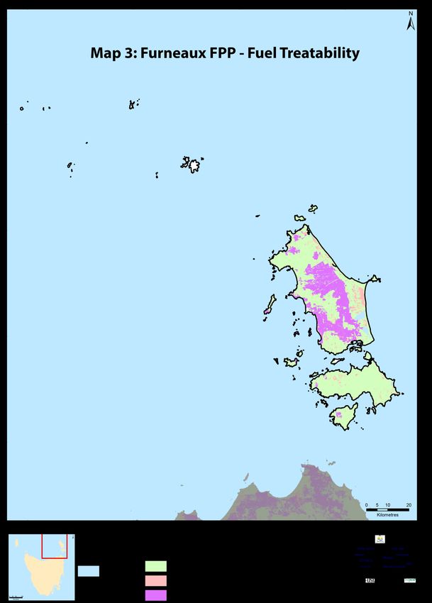
safer and more effective

Community             A strategic plan that focuses on addressing bushfire hazards, and improving the
Mitigation plan       survivability of communities and assets. The Bushfire Mitigation Plan identifies
                      key areas for fuel management, and provides tactical guidance regarding
                      prescribed burning, fuel treatment, fire management infrastructure, and asset
                      protection work

Consequence           Consequences are defined as a qualitative rating of damage from fire to values.

Fire Management       Classification system for the area to be managed. The zoning system indicates
Zoning                the primary fire management purposes for an area of land.

Human                 Term given for the dataset used to define where people live and work. The
Settlement Area       dataset was developed for the purpose of risk modelling and was created using
                      a combination of building locations, cadastral information and ABS data.
                      Includes seasonally populated areas and industrial areas.

Likelihood            Likelihood is defined as a qualitative method to assess the likelihood rating to
                      the consequences occurring

Risk                  The effect of uncertainty on objectives. (Note: Risk is often expressed in terms
                      of a combination of the consequences of an event and the associated likelihood
                      of occurrence.)

Risk Acceptance       The informed decision to accept a risk, based on the knowledge gained during
                      the risk assessment process.

Risk Analysis         The application of consequence and likelihood to an event in order to
                      determine the level of risk.

Risk Assessment       The systematic process of identifying, analysing and evaluating risk.

Risk Criteria         Standards (or statements) by which the results of risk assessments can be
                      assessed. They relate quantitative risk estimates to qualitative value
                      judgements about the significance of the risks. They are inexact and should be
                      seen as guidelines rather than rules.

Risk Evaluation       The process of comparing the outcomes of risk analysis to the risk criteria in
                      order to determine whether a risk is acceptable or tolerable.

Risk Identification   The process of recognising, identifying and describing risks.

Risk Treatment        A process to select and implement appropriate measures undertaken to modify
                      risk.

                                                                                                         6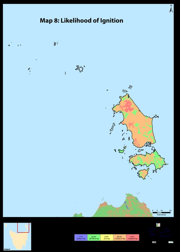
Acronyms

FIAT       Forest Industry Association Tasmania

FMAC       Fire Management Area Committee

FPP        Fire Protection Plan

FT         Forestry Tasmania

PWS        Parks and Wildlife Service

REMC       Regional Emergency Management Council

SEMC       State Emergency Management Committee

SFMC       State Fire Management Council

TFGA       Tasmania Farmers and Graziers Association

TFS        Tasmania Fire Service

ALCT       Aboriginal Land Council of Tasmania

LGA        Local Government Area

                                                       7
Chapter 1 Introduction
1.1 Background
Under Section 20 of the Fire service Act 1979, fire management area committees are required to
submit to SFMC, on an annual basis, a fire protection plan for its fire management area commencing
on 1 October.
It is a requirement of the fire protection plan that it is consistent with the State Fire Protection Plan
and the State Vegetation Fire Management Policy.
1.2 Aim and Objectives
The management of bush fire related risk is not the sole responsibility of any one land manager but
is a collective responsibility of the whole community. All members within a community have a
responsibility to assist with the management of bush fire risk.
The aim of this FPP is to document a coordinated and efficient approach towards the identification
and treatment of bushfire-related risk within the Furneaux Fire Management Area.
The objective of this FPP is to effectively manage bushfire related risk within the Furneaux Fire
Management Area in order to protect people, assets and other things valuable to the community.
Specifically, the objectives of this plan are to:
Guide and coordinate a tenure blind bushfire risk management program over a five (5) year
period;
Document the process used to identify, analyse and evaluate risk, determine priorities and
develop a plan to systematically treat risk;
Facilitate the effective use of the financial and physical resources available for bushfire risk
management activities;
Integrate bushfire risk management into the business processes of Local Government, land
managers and other agencies;
Ensure integration between stakeholders;
Clearly and concisely communicate risk in a format that is meaningful to stakeholders and
the community; and
Monitor and review the implementation of the Plan, to ensure enhancements are made on
an on-going basis.
1.3 Plan Context
The fire protection plan needs to be considered in terms of:
The fire protection plan is an approach to managing fire risk across the fire protection area
with a focus on community protection ;
Fire risk is not the sole prerogative of any one element of the community but a collective
responsibility of the whole community;
Risk management across the landscape can only be developed in terms of a cross tenure
approach;
8
Identification of risk and its management is an ongoing process based on new information
about values and consequences;
Risk treatments will be continuously be identified and programmed into the
implementation program;
The implantation program is an ongoing process and the plan will be subject to annual
review with regards to completed works.
1.4 Policy, Standards and Legislation
The following policy, standards and legislation were considered to be applicable to the development
and implementation of the FPP.
Tasmanian Emergency Management Plan;
State Fire Protection Plan 2013;
State Vegetation Fire Management Policy.
Standards
AS/NZS ISO 31000:2009 - Risk Management – Principles and Guidelines;
AS 3959 – 2009 - Construction of buildings in bushfire prone areas;
Forest Practices Code 2000;
Tasmanian Electricity Code.
Legislation
Aboriginal Relics Act 1975 (soon to be replaced);
Fire Service Act 1979;
Emergency Management Act, 2006;
National Parks and Reserve Management Act, 2002;
Nature Conservation Act, 2002;
Crown Lands Act, 1976;
Forestry Act 1920;
Tasmanian Forests Agreement Act, 2013;
Forest practices Act, 1985;
Threatened Species Protection Act, 1995;
Environmental Management and Pollution Control Act, 1994;
Local Government Act, 1993
9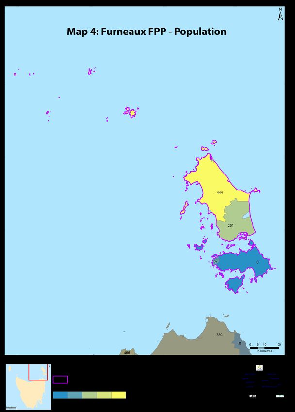
Chapter 2 Establishing the Context

2.1       Description of the Furneaux Fire Protection Plan Area
      2.1.1 Location, Boundaries and Land Tenure
      The fire management area covers the Flinders local government area (LGA). The LGA extends
      from near the coastline of Victoria to the Tasmanian mainland. The major land components
      within the municipality are the Furneaux group, Hogan group and the Kent group of islands
      (map 1).

      The Furneaux island group is an archipelago of approximately 50 islands located in Bass Strait
      between mainland Australia and Tasmania. The largest island is Flinders Island followed by
      Cape Barren and Clarke Island.

      The fire protection plan encompasses all the islands and the area covered is approximately
      206046 hectares. There exist a variety of tenures present within the fire management area
      including:

                      Tenure type                       Area m2                  Percentage of
                                                                                    region
       Private Freehold                               1286179464                    63.31%
       Conservation Area                               346143096                    17.04%
       Nature Reserve                                 117208025.1                    5.77%
       Game Reserve                                   103777568.7                    5.11%
       National Park                                  100048886.9                    4.92%
       Nature Recreation Area                         52586341.64                    2.59%
       Local Government                                5169062.06                    0.25%
       Casement                                       4618815.365                    0.23%
       Public Reserve                                 3458834.041                    0.17%
       Conservation Covenant                          3515762.651                    0.17%
       Crown Lease or Licence                         2726037.617                    0.13%
       Crown Land                                     2075957.782                    0.10%
       Private Sanctuary                               1212636.86                    0.06%
       Private Nature Reserve                         997292.3947                    0.05%
       State Reserve                                  725065.3832                    0.04%
       Historic Site                                  350455.2209                    0.02%
       Hydro-Electric Corporation                     446065.9292                    0.02%
       Authority Crown                                225802.2667                    0.01%
       Authority Freehold                             88992.28484                    0.00%
       Local Government Act Reserve                   18293.01156                    0.00%
       Commonwealth                                   14820.00466                    0.00%
       Tas Water                                      47020.06992                    0.00%
      Table 1: Tenure Area

                                                                                                 10
Map 1: Location
11The principle land management agencies are:
Land Manager/Agency % of Land Managed within the FMA
DPIWE( including PWS and Crown land services) 34.48%
Private Parcel 34.10%
Aboriginal Land Council of Tasmania 25.41%
Dep’t of Economic Development 5.75%
Local Government Authority 0.24%
Hydro Electric Corporation 0.02%
Department of Education 0.01%
Commonwealth Of Australia < .01%
Table 2: Overview of Land management agencies within the Fire management Area
2.1.2 Climate and Bushfire Season
The Furneaux islands experience a climate that can be considered a mixture of a Mediterranean
and an oceanic climate that is composed of warm dry summers and mild wet winters. Rainfall is
possible in all seasons. Under the moderating influences of low elevation and the maritime
effects, the islands generally have a milder climate compared to that of Tasmania. The Furneaux
islands are in the path of the “roaring forties” with a prevailing westerly wind particularly during
the summer. The winds are persistent reaching their maximum in the afternoon.
The mean daily maximum temperature is 17.7oC with a range from 13.3oC in July through to
22.1oc in February (BOM 2014). Similarly the mean daily minimum temperatures are 9.8oc
ranging from 13.7 oc in February through to 6.20c in July. Mean daily sunshine hours range from
3.7 hours in winter through to 7.8 hours in summer. The daily mean 3.00 pm relative humidity is
approximately 65 % over all months.
Automatic weather stations exist at the Flinders Island airport and on Hogan Island.
The fire season is traditionally from November through to March though fires can and do occur
outside this peak season.
2.1.3 Vegetation
The vegetation of The Furneaux Island is a mix ranging from heaths, scrub and dry woodlands
through to dry sclerophyll forest interposed with wet sclerophyll forest gullies and remnant
rainforest on Mt Strzelecki and the Darling Range. The region is considered to be important
biogeographically as it is indicative of an ecotone between the Tasmanian and mainland
vegetation complexes. Some of the vegetation species present on the islands are at the most
southern point of its range if a mainland species or the most northern aspect of Tasmanian
endemic species.
The Tasmanian vegetation mapping program coordinated by the Department of Primary
Industries Parks Water and the Environment (DPIPWE), has classified the vegetation of
Tasmania into 162 mapping units with the majority based on ecological vegetation
communities. This data is represented in the TasVeg 3 map. The classification of ecological
vegetation communities is often an artificial process as vegetation exists as a complex
continuum (Kitchener and Harris, 2013)
12The vegetation can also be categorised into 12 broad groups that represent broad vegetation or
landscape types. A description of the vegetation groups can be found in Appendix 10. A
breakdown of the principle vegetation groups present within the Furneaux region as per TasVeg
3 classification is:
Flammability
(Pyrke and Marsden-Smedley,
Vegetation Group( Tas Veg 3, 2013) 2005) % of FMA
Scrub, heathland and coastal complexes High – very high 42.12
Agricultural, urban and exotic vegetation moderate 25.47
Dry eucalypt forest and woodland Moderate - high 14.87
Non eucalypt forest and woodland moderate 6.90
Native grassland high 3.48
Saltmarsh and wetland low 3.43
Other natural environments moderate 3.19
Moorland, sedgeland, rushland and peatland Moderate - high 0.38
Rainforest and related scrub low 0.15
Table 3: Vegetation groups
The majority of the vegetation groups in the Furneaux group can be considered to be of a high
to very high flammability classes with a low to moderate sensitivity to fire (Pyrke and Marsden-
Smedley, 2005). The exception is the rain forest complexes on Mt Strzelecki which is very
sensitive to fire as well as being of low flammability. Similarly the Melaleuca ericifolia swamp
forest scattered around the island is very sensitive to fire though also being of low flammability.
The vegetation can also be considered in terms of its “treatability” with regards to fuel
reduction programs. Treatable fuels suitable for planned burns are typically dry eucalypt forest,
scrub complexes, heath complexes and button grass. Agricultural lands while susceptible to the
impact of bush fires are not consider treatable due to the nature of the land use. However this
does not preclude agricultural land from being incorporated into burning operations.
The majority of fuels on the islands are considered to be treatable (map 3).
2.1.4 Population and Demographics
The estimated resident population of the Furneaux Islands is 784 persons as of 2013(Flinders
Council web site, 2014, map 4). Flinders Island has two major population centres, Whitemark
and Lady Barron. Other settlement areas included Emita, Palana, Memana, and Killiecrankie.
Outside the settlement areas, the population is based around farm holdings. Whitemark is the
administrative and commercial centre for the Furneaux region
A smaller population of approximately 60 persons reside on Cape Barren Island. The outer
islands have transient populations based around agricultural needs.
The community profile of the Furneaux region indicates that The Furneaux Island Group had a
lower proportion of preschoolers and a higher proportion of persons at post retirement age
than Regional TAS in 2011(Profile.id.com.au/flinders-island). Analysis of the service age groups
of the Furneaux Island Group in 2011 compared to Regional TAS shows that there was a lower
proportion of people in the younger age groups (0 to 17 years) and a higher proportion of
13people in the older age groups (60+ years). Overall, 15.7% of the population was aged between
0 and 17, and 31.8% were aged 60 years and over, compared with 23.3% and 24.0% respectively
for Regional TAS.
Agriculture, fishing and aquaculture together with tourism and hospitality are the principle
industries in the Furneaux islands. The agriculture and fishing sectors employ 23.3 % of the
population.
The population trend over the last few years has been a gradual reduction of people present on
the island. As a consequence of this decreasing population, there is an increased level of
absentee landowners and an increased no’s of iterant holiday visitors.
The communities of Whitemark, Lady Barron and Cape Barren are home to the islands primary
built environment. Built environment constitutes: Multi-Purpose Centre, Whitemark, Cape
Barren Health Centre, residential properties, businesses industrial properties and holiday
homes. Some development is occurring in the coastal zone adjacent to the West End road.
There are no major areas on the island where significant development growth is occurring
2.1.5 Bushfire Frequency and Causes of Ignition
Before major settlement of the island, it is likely that there was repeated burning of the island
though fires ignited by lightning strikes. Such fire will have travelled through the landscape till
sufficient rains extinguished the fire. The island have been subject to a range of fires with
analysis indicating that the majority of incidents are located either near communities or in the
Agricultural landscape. In recent years, the island has been subject to several severe fires that
have impacted on both the community and the natural environment. Major fires include:
Fire name Ignition date size
Sellers Point 1990 578 Ha
Darling Range 2003 170567 ha
Cameron Lagoon 2003 4261 ha
Reedy lagoon 2006 1716 ha
Cape Barren Island (Apple 2006 42000 ha
Orchard Point)
Five Mile Road 2008 6690 ha
Clarke Island 2013 8100 ha
Table 4: Major fires
There is a paucity of fire records for the planning area where ignition sources have been
identified. Analyses (map 5) of the records that exist indicate that the principle causes of
ignition are:
Ignition source % of ignitions
Unknown 59.88%
Lightning 23.52%
Escapes from planned burns 5.88%
Arson 10.7%
Table 5: Ignition Causes
14Chapter 3 Analysing and Evaluating Bushfire Risk
3.1 Analysing Bushfire Risk
Following the Australian Standard of risk (ISO 3100) bushfire risk has been considered spatially,
assessing a combination of likelihood and consequence (PWS 2011). The Bushfire Risk Assessment
Model (BRAM), model data run of November 2013 was used to analyse the landscape level risk for
this plan. For a full analysis of the model, see Appendix 2.
To determine overall risk the NERAG (National Emergency Risk Assessment Guidelines August 2009)
document (see Appendix 3) was used. The level of risk is determined by combining consequences
and likelihood (see Appendix 3).
It must be noted that the BRAM and therefore the consequences, likelihood and risk outputs are
based on available spatial data. The analysis has been undertaken on a statewide basis, and maps
are presented as complete for Tasmania. There are however gaps in the data inside and outside
areas of public land. This includes fire history information, particularly on private land, which
contributes to ignition potential information (likelihood), and many of the agricultural values have
not been well captured (consequence). Notwithstanding these limitations, the model does provide
an objective spatial analysis of bushfire risk in a landscape context.
3.2 Likelihood
Likelihood is defined as a qualitative method to assess the likelihood rating to the consequences
occurring. The likelihood of an event was generated by calculating ignition potential, suppression
capabilities and fire behaviour potential, followed by assigning these output values to categories in a
likelihood matrix. This is taken to mean the likelihood of a fire occurring in a specific area which
surpasses the ability of the fire agencies to contain within the first 24 hours.
3.3 Consequence (values at risk)
Consequences are defined as a qualitative rating of damage from fire to values. The consequences
were taken directly from the output generated through the Values at Risk spatial layer output
(appendix 2). Region wide values utilised in the BRAM modelling include:
Constructed values
Wildland urban interface;
Critical infrastructure including transmission lines, telecommunication infrastructure and
transport links
Burnable infrastructure;
Heritage buildings;
Non burnable;
Neighbouring houses ( life);
Parks and wildlife asset base including life
Forest/ agricultural
Production Forest both state owned and private;
Horticulture production;
15 Research monitoring sites.
Natural values
Flora and Fauna( fire sensitive and threatened species);
Water catchments;
Geo-morphic values
While the values layer identifies a wide range of values in the Furneaux fire management area, the
agricultural grassland and its economic significance are not part of the analysis. The agricultural
grassland community is of particular importance with the loss of extensive grass impacting on the
immediate viability of farming enterprises. This is compounded by the difficulty and cost n
transporting feed to the island after a major bushfire event. The loss of grasslands has a major
impact on the island economy.
Other values at that need to be understood when examining risk is the critical infrastructure present.
Critical infrastructure on the islands includes:
Flinders Island Airport;
Hydro Tasmania Power station Flinders island;
Fuel Dump Lady Barron;
Whitemark jetty;
Lady Barron jetty/ wharf;
Tas Water supply infrastructure (Lady Barron pump station, Vinegar Hill water reservoir, Pats
River Pump station and water reservoir (Whitemark);
UHF/VHF repeater networks - Walkers lookout;
Flinders Island District High School;
Flinders island Multi-purpose Centre and hospital;
Hydro Tasmania Diesel fired Power station - Cape Barren.
Flinders Island Emergency Services Building (Whitemark)
Telecommunications (Telstra) infrastructure (Mt Tanner, Vinegar Hill, Hayes Hill, Middle
Patriarch Hill, Whitemark Post Office)
3.4 Overall Risk
A representation of risk (see Appendix 4) is developed when you combine the factors of likelihood
and consequence. The generated output map of risk shows qualitative areas of risk, not areas of
perceived risk.
The model assists in objectively defining areas where genuine risk is present. In-depth analysis will
indicate what factor is driving the risk for a given area
3.5 Risk Analysis for the Furneaux Fire Management Area
The bush fire risk Model BRAM was utilised to examine risk across the fire management area. For a
simplified explanation of the BRAM model and associated NERAG process see appendix’s 3 and 4.
16In addition Phoenix Rapidfire, a bush fire simulator, developed by the University of Melbourne
(Kevin Tolhurst and Derek Chong) was used to model the risk of fires impacting on communities
present in the FMA. This modelling was done as part of the state wide strategic fuel management
assessment. The process involved modelling potential ignition points, incorporating worst case
scenario weather patterns and examining fire behaviour based on current fuel loads to identify the
potential impact on human settlement areas.
An understanding of where potential ignition point that may impact on communities is crucial.
It must be understood that such analysis has many limitations but does provided an indication a
where communities may be under risk as well as identify areas where strategic burning will assist in
changing fire behaviour
Output maps identifying risk, likelihood of ignition and potential ignition points are outlined in
appendix 5
3. 5.1 Community Assessment
Strategic assessment tools have been used to conduct a broad scale assessment across the Furneaux
Fire Management Area to identify communities vulnerable to bushfire, that require more detailed
assessment using more locally specific processes. Selection and prioritisation of treatments was
done using a combination of:
BRAM and Phoenix computer modelling results
Expert opinion of fire practitioners(TFS and PWS)
Local knowledge from Tas Fire Service District Officers and Brigades.
Identification and consideration of existing and past fire management actions and plans
Consultation with TFS Community Protection Planners
The results of the strategic assessment for the Furneaux Fire Management Area are outlined below
in Table 6.
Human settlement Area Assessment Rating Priority
Lady Barron High High
Emita High High
Cape Barren(the corner) High High
Big River High High
West End High High
Killiecrankie Mod Mod
Palana Mod Mod
Whitemark Mod Mod
Table6: Results of the Strategic Assessment
While an initial categorisation of priority is highlighted, all human settlement areas have effectively
the same priority. The priority for implementation of these risk management strategies for the
designated human settlement area will be subject to availability and resources required to develop
plans and implement the programs.
A number of communities already have specific plans in place, these are summarised in Appendix 5.
17Chapter 4 Bushfire Risk Treatment
4.1 Planning framework
Fire management zoning is a classification system for the area to be managed. Zoning provides a
framework by identifying where fire preparedness works and planned burning should occur.
Ellis etal, 2004 recommended that all jurisdictions in should adopt a zoning strategy to assist with
mitigation planning particularly fuel management areas. The process should be applied at a
landscape level but the concept can be applied to localised community protection. Ellis etal, 2004
also highlights that the rural–urban interface and the agriculture – conservation reserve interface
are the areas where bushfire poses the greatest risks to lives, property and economic values????
The most effective way of managing these areas is by identifying ‘fire management zones’ across the
landscape and having clear objectives for each zone.
Clear objectives for each zone should be outlined and stakeholders and the community should be
involved. The fire management zones to be used in developing fire strategies/ mitigation plans
within the Furneaux fire protection area are:
Asset. This is a feature that is either man made or natural of significant value in which a
fire will have negative impact;
Asset Protection Zone. This is typically the rural–urban interface, where regular fuel
reduction should be undertaken in the vicinity of specific assets. This zone provides the
highest level of localised protection to human life property and highly valued assets.
Mitigation works may include mechanical fuel modification, fuel reduction burning,
evacuation, and engineering and community awareness and preparation programs.
Strategic Fuel Management Zone. This aims to provide areas of reduced fuel in strategic
areas, to reduce the speed and intensity of bushfires and reduce the potential for spot-fire
development.
Land Management Zone. The primary purpose here is to meet the objectives of the relevant
land manager, which can be planned fire for fuel reduction, biodiversity conservation or
forest regeneration.
4.1.1 Community risk management
In developing mitigation plans for local communities, the strategic methodology by Ellis etal 2004
outline above is to be to be used as the basis of the mitigation planning process. Mitigation plan
provides a means of articulation and managing risk for human settlement areas.
The strategies to be used in developing fire mitigation plans include:
Zoning as per COAG recommendations 2004( Ellis etal 2004);
Fire and Management Regimes - Fuel reduction burning including criteria / triggers for
repeated burning;
Other Fuel treatments such as Slashing;
Fuel breaks;
Fire ready neighbour development programs.
18In addition, 2 other planning processes need to be developed and incorporated into the works
programs to manage the risk present with the fire management area
Community bushfire protection planning (TFS) Community Bushfire Protection Plans are
prepared for community members that provide local information to assist with bushfire
preparation, and survival.
Community bushfire response planning (TFS); Community Bushfire Response Plans are
prepared for emergency managers to better protect communities and their assets during
bushfire emergencies.
4.2 Region Wide Controls
The following controls are currently in place across the Furneaux fire management area to assist in
the strategic management of bushfire related risk:
Legislative controls – including abatements, fire restrictions etc.
Public education campaigns and the use of TFS and SFMC state-wide programs tailored to
suit local needs; (e.g. Private land burning; Community Protection Planning; Bushfire Ready
Neighbourhoods)
State-wide arson prevention programs developed in conjunction with TAS Police and TFS;
Setting of appropriate land subdivision and building standards in line with State Bushfire
Prone Area Building Standards;
Performance monitoring and reporting of FPP outcomes to the relevant Emergency
Management Council and State Fire Management Council as required by the Tasmanian
Emergency Management Plan and the Fire Service Act
4.2.1 Strategic fire infrastructure
Strategic fire infrastructure includes critical fire access tracks and water sources. Critical fire
infrastructure identified for the island (map??) Includes:
4.2.1.1 Strategic fire trails
To be of strategic value, fire trails should be located in the following situations:
Adjacent to the assets which they are required to protect;
Lead to strategic water sources;
Break up large tracts of contiguous flammable vegetation;
to facilitate access and egress to assets;
To provided boundaries for prescribed burning blocks.
Strategic fire trails identified on Flinders and Cape Barren Islands are:
Strategic Trail Start(UTM GDA94) Finish(UTM GDA94) Standard required
Logan’s lagoon 608080 55553010 611410 5554360 Class 5
Haulands Gap 589400 5563800 596700 5562000 Class5
Brougham Sugarloaf 589274 5564632 582119 5567591 Class 5
Wallanipi to Badger 591151 5550861 601111 5546339 Class 5
Summers Road to 601300 5569200 609600 5574500 Class 5
19Sellers Point
Sawyers Bay track 578398 5569397 583863 5572272 Class 5
Mt Tanner to Boat 570442 5584486 570549 5587248 Class 5
Harbour
Wingaroo to Foochow 587131 5588570 592356 5588050 Class 5
Beach
Table 7: Fire Trails
Fire trails should be maintained to an appropriate standard. Currently the only standards within
Tasmania dealing with fire infrastructure are the PWS’s Fire Management Infrastructures Categories
and standards v4 and the forest practice code. These documents should be used as a guide in the
maintenance of fire infrastructure.
Not all access tracks will be considered critical fire infrastructure though they may have use in fire
operation. Such tracks may be maintained for a variety of purposes including management and
recreation activities. The decision to maintain will be the prerogative of the land manager (including
private landowners) controlling access to such a track.
4.2.1.2 Fire breaks
Wingaroo
Lady Barron
4.2.1.3 Strategic roads
Strategic roads link to the strategic fire trails. They also provide good control lines especially in the
advent of rapidly moving grass fires.
Identified Strategic road on Flinders Island are:
Five Mile road;
Cameron Inlet road;
Logan Lagoon road;
Summers road;
Memana road to Patriarchs Inlet.
For effective use in a wildfire event, the vegetation adjacent to the strategic road should be reduced.
The minimum standard of vegetation clearance should be 5m either side of the asset. Slashing of the
roads side verge is the preferred method for managing the vegetation.
4.2.2 Strategic Burning program
The fuel loads in the strategy area are such that any wildfire has the potential to impact on a range
of assets including residential properties. The objective of managing this risk is to modify the fire
behaviour of any wildfire so that there exists, an improved window of opportunity to control or
contain wildfire events. The basic strategy is to develop a mosaic of fuel reduced areas within the
strategy area over a time frame of several years through the use of the most suitable methods. The
imposition of a burning regime that establishes a mosaic of burns can be used to ensure wildfire
impacts are minimised. It also ensures fire dependent species are maintained. Appropriate
20techniques may include but are not restricted to such processes as fuel reduction burning, slashing
and fire break construction.
A strategic burning program to be commenced with the aim of reducing fuels across the fire
management area. The program is to concentrate particularly on:
Darling Range;
Mt Strzelecki;
East Coast ( Down to lady Baron and the Pot Boil);
Mt Tanner.
Other areas to be targeted are Castle Rock, Shag lagoon and the Dutchman and selected blocks of
native vegetation on private property.
The initial potential strategic burning program for the Furneaux Fire Management area is identified
on map 11, appendix 8. Selection of the initial burn blocks is based on identification of treatable
fuels, previous fire history, the need to reinforce existing fire trails and the need to implement a
mosaic of fuel reduced areas across the landscape.
Strzelecki National Park and Wingaroo Nature Reserve are identified as high risk areas though not
with regards to communities. The risk is generated by and to natural values present in the blocks.
The fuels present within these areas need to be reduced in such a way that they do not create
environmental damage to the values present. PWS is to develop a fuel reduction strategy for Mt
Strzelecki and Wingaroo NR.
4.3 Asset Specific Treatment Strategies
There are five broad asset specific treatment strategies that have been used to manage the bushfire
risks identified in the Community Risk Assessment. They include:
Fuel management – Treatments include the reduction / modification of bushfire fuels
through manual, chemical and prescribed burning methods;
Ignition management - Treatments aim to reduce the occurrence of human induced ignitions
in the landscape;
Preparedness – Treatments focus on providing suitable access and water supply
arrangements that will assist with firefighting operations;
Planning – Treatments relate to the development of plans that will improve the ability of
firefighters and the community to respond to bushfire; and
Community Engagement – Treatments seek to build relationships, raise awareness and
change behaviours relating to the management of bushfire related risks within the
community.
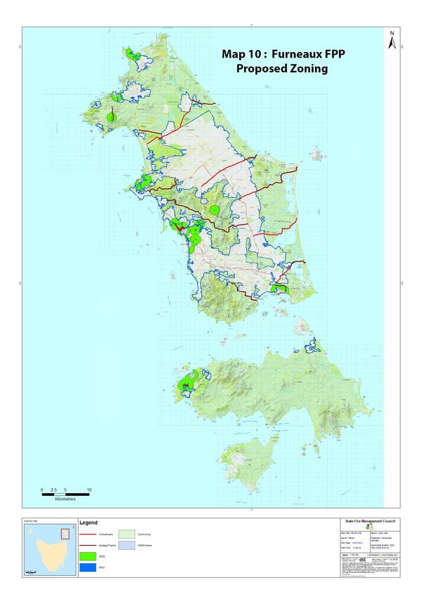
4.4 Treatment Selection and Priorities
A strategic bushfire risk assessment has been undertaken for the entire Furneaux Fire Management
Area. This strategic assessment was used to identify key communities and assets considered to be at
risk of bushfire and prioritise the preparation and implementation of different treatment strategies.
21In developing strategies for addressing the risk the fire management area was zoned to identify
areas that require works. This was in addition to the examination of the risk outline above.
Principally the islands were zoned based on:
Asset protection zones around human settlement areas;
Asset protection zones around critical assets including major agricultural grass lands.
The zoning identified for the fire protection area is shown on Map 1.
General risk management approaches to the major human settlement areas present on the islands
are:
Lady Barron - development of mitigation plan, development of a community protection and
responses plan together with implementation of a Bush Fire Ready Neighbourhood
Program;
Emita - development of mitigation plan, development of a community protection and
responses plan together with implementation of a Bush Fire Ready Neighbourhood Program;
The Corner (Cape Barren Is.) - development of mitigation plan, development of a
community protection and responses plan together with implementation of a Bush Fire
Ready Neighbourhood Program;
Killiecrankie - development of a community protection and responses plan together with
implementation of a Bush Fire Ready Neighbourhood Program;
Palana development of a community protection and responses plan together with
implementation of a Bush Fire Ready Neighbourhood Program;
West End - development of a community protection and responses plan together with
implementation of a Bush Fire Ready Neighbourhood Program;
Blue Rocks - implementation of a Bush Fire Ready Neighbourhood Program
Big River- implementation of a Bush Fire Ready Neighbourhood Program;
Whitemark- development of a community protection and responses plan together with
implementation of a Bush Fire Ready Neighbourhood Program.
4.5 Implementation Program
Under the terms of reference for the Flinders Fire Management Area Committee (FMAC), the
committee has objectives to:
Provide a point of coordination and cooperation for FMAC members.
Review plans and processes to ensure interoperability between stakeholders and the
broader community.
The fire area management committee (FMAC) will coordinate the implementation strategy identified
in appendix 6. The committee will be involved in identifying organisation or agencies to complete
the risk management strategies required under the fire protection plan. Implementation of the
various risk management controls and strategies identified in the fire protection plan will be the
responsibility of the identified land manager/ agency.
The FMAC will liaise with the State fire council to develop a strategy to address funding for works
and risk management strategy’s to address community obligations.
224.6 Implementation
When the treatments identified in this FPP are implemented there are a number of issues that need
to be considered by the responsible agency including
1. Environmental impact and assessment;
2. Aboriginal and European heritage;
3. Prescribed burn plans and approvals;
4. Smoke management associated with planned burning programs;
5. Community consultation;
6. Community partnerships.
Chapter 5 Monitoring and Review
Monitoring and review processes are in place to ensure that the FPP remains current and valid.
These processes are detailed below to ensure outcomes are achieved in accordance with the
Implementation Schedule.
5.1 Review
This FPP, including appendices, will be subject to a comprehensive review every five (5) years from
the date of approval, unless significant circumstances exist to warrant earlier review. The review
process would include examination of:
Changes to the FPP area, organisational responsibilities or legislation;
Changes to the bushfire risk in the area; or
Following a major fire event.
In addition, the fire management area committee should identify:
Shortcomings in data
Change of usage of the area
New or changes to asset values within the fire protection area
Data shortcomings and changes to values (both community and natural) identified by the review
process are to be passed to the state fire council for inclusion in ongoing risk modelling being carried
out at the state level.
In addition, to complete the NERAG assessment process, the development of an asset risk register
detailing specific risk treatments should be developed. Information derived from this process is to
be incorporated into individual community mitigation plans as well as the wider strategic FPP.
5.2 Monitoring
The implementation program at Appendix 6 is a living document and progression towards
completion of the treatments proposed will be monitored and reviewed at least every six (6) months
by the FMAC
At a state wide level, the State fire council will be examining the impacts of the strategic burning
program on risk management as part of the strategic fuel management program
23The implementation program will be updated as treatments are progressed and completed.
5.3 Reporting
A report detailing progress towards implementation of this FPP will be provided annually. Reporting
performance criteria should address;
Planning outcomes including mitigation plans, community protection plans, community
response plans;
Implementation progress of community mitigation programs;
Completed strategic burns;
Development and maintenance of strategic fire infrastructure.
24References
Ellis, S., Kanowski, P., & Whelan, R., 2004, National Inquiry on Bushfire Mitigation and
Management, Commonwealth of Australia, Canberra;
Kitchener, A., and Harris, S., 2013, From Forest to Fjaeldmark: Descriptions of Tasmanian Vegetation
Edition 2, Department of Primary Industries, Parks, Water and Environment, Hobart;
http//Profile.id.com.au/flinders-island accessed 12/5/2015
National Emergency Management Committee, (2010), National Emergency Risk Assessment
Guidelines, Tasmanian State Emergency Service, Hobart;
Parks and Wildlife Service (unpublished), Bushfire Risk Assessment Model Project Business Process
Model (2008). Department of Primary Industries, Parks, Water and Environment, Hobart.
Parks and Wildlife Service (unpublished). Tasmanian Bushfire Risk User Guide (2010). Department of
Primary Industries, Parks, Water and Environment, Hobart;
Parks and Wildlife Service (unpublished). Tasmanian Bushfire Risk Assessment Model (2013).
Department of Primary Industries, Parks, Water and Environment, Hobart;
Parks and Wildlife Service, 2009, Northern Region Strategic Fire Management Plan, Department of
Primary Industries, Parks, Water and Environment, Hobart;
Pyrke A.F. and Marsden-Smedley J.B., 2005, Fire-attributes Categories, Fire sensitivity and
flammability of Tasmanian vegetation communities, Tasforests 16: 35-47, Forestry Tasmania, Hobart
State Fire Management Council, 2014, Bushfire in Tasmania: A New Approach to Reducing Our
Statewide Relative Risk. Department of Police and Emergency Management, Hobart.
25Appendices
Appendix 1 – Maps of FMAC area displaying context information
Map 2: land Tenure
26Map 3: Fuel Treatability
27Map 4: Population
28Map 5: Ignition Cause
29Map 6: Vegetation Groups
30Appendix 2 - The Bush Fire Risk Model (BRAM)
Background
The Bushfire Risk Assessment Model (BRAM) is a software product that was developed by the
Fire Management Section of the Parks and Wildlife Service (Department of Primary Industries,
Parks, Water and Environment). The aim of the model is identify bush fire risk at a strategic
level as well as to identify the elements driving actual bush fire risk.
A stakeholder group was set up to oversee the process. Stakeholders involved in developing the
process included:
o Parks and Wildlife Service;
o Tasmania Fire Service;
o Forestry Tasmania;
o Tasmanian Farmers and Graziers Association;
o State Emergency Service:
o Forest Industries Association of Tasmania;
o Local Government Association of Tasmania;
o Resource management and conservation, DPIPWE;
o Natural Resource Management(NRM) ;
o Tasmanian Aboriginal land and Sea Council ;
Additional working groups were set up to provide advice on specialist areas such as values at
risk, suppression capabilities, ignition potential, and fire behaviour.
The process is aligned to the Australian/New Zealand Standard AS/NZS 4360:2004 Australian
Standard Risk Management and the updated standard AS/NZS ISO 31000:2009 Risk management
– Principles and guidelines. Risk is defined as the” effect of uncertainty on objectives” with a
focus of the effect on the objectives
The process
The model is built in a geographic information system that utilizes various spatial orientated
data, fire behaviour and fuel accumulation models and climate records. The data and values
were developed by consensus of a range of stakeholders
The process applies the same set of assessment rules to the data contained in the model, thus it
can be applied across the state. The process is tenure blind
The BRAM identifies the likelihood and consequence of a fire at a particular point. The risk
is determined through the use of a qualitative risk matrix incorporating likely hood and values
at risk (consequences). The process identifies the actual risk at that point not the perceived risk.
The output is in the form of layers identifying the likelihood, values at risk and actual risk
The model uses 4 major areas to calculate risk
o Fire behaviour potential - the manner in which fuel ignites, flame develops, and
fire spreads and exhibits other related phenomena (likelihood).
o Ignition potential - the probability or chance of fire starting as determined by the
presence of causative agents (likelihood).
o Suppression capability - the factors and limitations that are related to the ability
to contain a bushfire upon detection (likelihood).
31o Values at risk - a specific or collective set of natural resources and man-made
improvements and/or developments that have measurable or intrinsic worth,
and which could potentially be destroyed or otherwise altered by fire in any
given area (consequence
Ignition potential
32Suppression capabilities
33Fire Behaviour Potential
34Values at risk
Limitation of the process
BRAM does not incorporate the likelihood and consequence at the same point from a
fire occurring in an adjacent area.
BRAM does not display the risks posed by an area adjacent to a particular point.
35 Mitigation works undertaken on adjacent areas do not change the risk at a particular
point.
The process is based on available data, there are significant gaps in data e.g. fire history
on private lands,
Untested assumptions – may over/underestimate risk
36Appendix 3 – NERAG risk assessment approach
(Derived from the National Emergency Management Committee (2010), National Emergency Risk Assessment Guidelines,
Tasmanian State Emergency Service, Hobart)
The NERAG provide a methodology to assess risks from emergency events and are principally
concerned with risk assessment. The NERAG methodology was utilised in development of the BRAM
to develop the final risk profile
The guidelines are not intended to address the entire risk management framework or the risk
management process as outlined in AS/NZS ISO 31000:2009. However, because they focus on the
assessment of risks from emergency events, they ultimately direct the management of emergency
risks in line with the international standards for risk management.
The guidelines aim to provide a risk assessment methodology that:
enables focus on risks in small (e.g. municipal) or large (e.g. regional and/or state and/or
national) areas
is useable for both risk ‘from’ and risk ‘to’ (e.g. risk from bushfire, risk to infrastructure from
all or specific sources of risk)
uses a scenario-based approach
samples risk across a range of credible consequence levels
identifies current risk under existing controls and residual risk assuming implementation of
additional controls or control improvements
provides base-line qualitative risk assessments and triggers for more detailed analysis
allows risk evaluation at varying levels of confidence
Provides outputs that are comparable, which rate risk and suggests means to reduce risk.
Risk analysis is the element in the process through which the level of risk and its nature is
determined and understood. Information from risk analysis is critical to rank the seriousness of risks
and to help decide whether risks need to be treated or not. In this phase, control opportunities are
also identified. The analysis involves consideration of possible consequences, the likelihood that
those consequences may occur (including the factors that affect the consequences), and any existing
control that tends to reduce risks. During this phase the level of confidence in the analysis is
assessed by considering factors such as the divergence of opinion, level of expertise, uncertainty,
quality, quantity and relevance of data and information, and limitations on modelling. At the
conclusion of this step, all identified risks are categorised into risk levels and given a risk rating, and
statements concerning existing controls and their adequacy are made.
NERAG takes an all hazards approach and provides a method that is suitable for considering other
sources of risk beside fire
37You can also read