King Island Fire Management Area
Bushfire Risk Management Plan
2021
←
→
Page content transcription
If your browser does not render page correctly, please read the page content below
King Island Fire Management Area Bushfire Risk Management Plan 2021
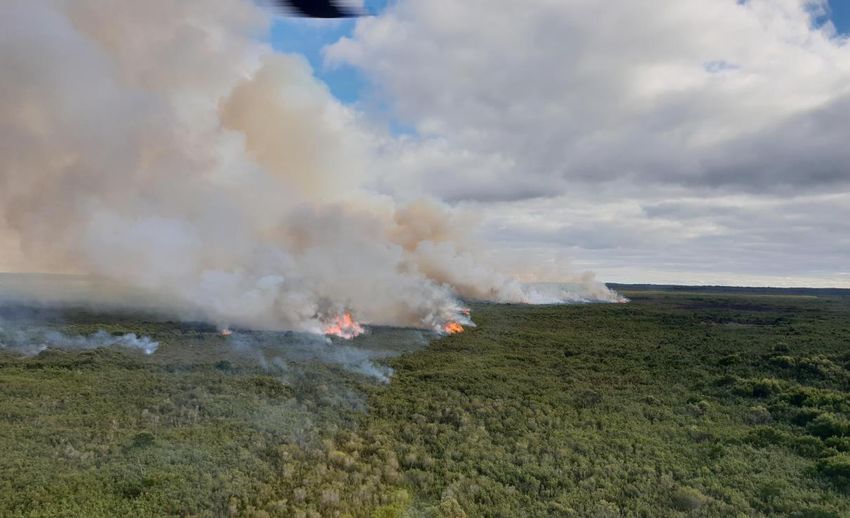
Document Control
Document History
 Version                 Date                   Author                  Section
 1.0                     01/2021                C Heyworth              Bushfire Risk Unit

Document Endorsements
 Agency                  Name & Title           Signature               Date

Document Endorsement by King Island Fire Management Area Committee

Nicholas J Cooper, Chair, King Island FMAC

Date: 11/03/2021

Accepted by State Fire Management Council

Ian Sauer, Chair, SFMC

Date: 30/03/2021

Cover Page Photo Acknowledgement: Fuel Reduction Burn, Blowhole Road, July 2020, photo courtesy
of David Fulford
Contents
Glossary ....................................................................................................................................... 5
Acronyms ..................................................................................................................................... 7
Executive Summary ...................................................................................................................... 8
1.       Introduction ..................................................................................................................... 11
         1.1 Background ........................................................................................................................... 11
         1.2 Purpose of this plan .............................................................................................................. 11
2.       Establishing the context .................................................................................................... 13
         2.1 Description of the King Island Fire Management Area ......................................................... 13
         2.2 Fire environment................................................................................................................... 13
         2.3 Climate and bushfire season ................................................................................................. 16
         2.4 Population and community ................................................................................................... 18
         2.5 Community engagement....................................................................................................... 18
3.       Identifying the risks .......................................................................................................... 19
         3.1 Bushfire and impact scenarios .............................................................................................. 19
         3.2 Statewide controls ................................................................................................................ 19
         3.3 Fire Management Area controls ........................................................................................... 20
4.       Analysing and evaluating bushfire risk ............................................................................... 21
         4.1 Analysing bushfire risks ......................................................................................................... 21
         4.2 Evaluating bushfire risks ....................................................................................................... 21
5.       Bushfire risk treatment ..................................................................................................... 22
         5.1 Treatment plan...................................................................................................................... 22
         5.2 Bushfire management zones................................................................................................. 22
         5.3 Implementing treatments ..................................................................................................... 23
         5.4 Strategic fire infrastructure ................................................................................................... 23
         5.5 Fuel reduction burning .......................................................................................................... 24
6.       Monitoring and review ..................................................................................................... 25
         6.1 Review ................................................................................................................................... 25
         6.2 Monitoring and reporting ..................................................................................................... 25
References ................................................................................................................................. 26
Appendices ................................................................................................................................ 27
         Appendix 1: Risk Register ............................................................................................................ 27
         Appendix 2: Treatment plan ....................................................................................................... 32
         Appendix 3: Bushfire Management Zones .................................................................................. 35
         Appendix 4: Strategic Fire Infrastructure .................................................................................... 36
         Appendix 5: Current implementation plans................................................................................ 38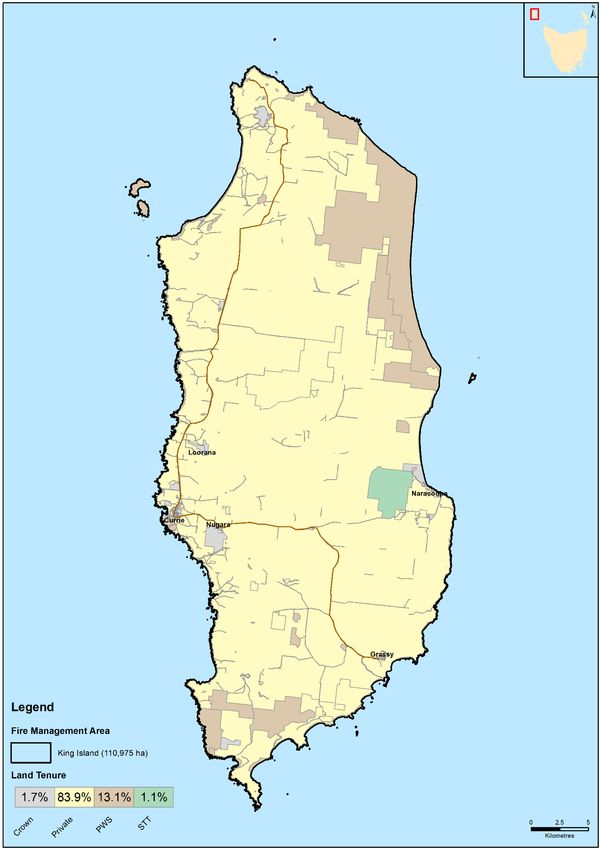
Maps ......................................................................................................................................... 39
         Map 1: King Island Fire Management Area location ................................................................... 40
         Map 2: Tenure summary map for King Island Fire Management Area....................................... 41
         Map 3: Assets and values from the risk register for King Island Fire Management Area ........... 42
         Map 4: Fuel treatability for King Island Fire Management Area................................................. 43
         Map 5: Vegetation for King Island Fire Management Area ........................................................ 44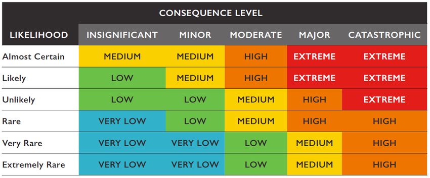
Glossary

Glossary
Asset                   A term used to describe anything valued by the community that may be adversely impacted
                        by bushfire. This may include houses, infrastructure, agriculture, production forests, industry,
                        and environmental and heritage sites.
Asset Zone (AZ)         The geographic location of asset(s) and values of importance requiring bushfire exclusion.
Asset Protection Zone   An area adjacent to or near Asset Zones, the primary management purpose of which is to
(APZ)                   protect human life, property and highly valued assets and values. Treatment can include
                        intensive fuel reduction, manipulation of fuel moisture or response plans.
Bushfire                Unplanned vegetation fire. A generic term which includes grass fires, forest fires and scrub
                        fires both with and without a suppression objective.
Bushfire hazard         The potential or expected behaviour of a bushfire burning under a particular set of
                        conditions, i.e. the type, arrangement and quantity of fuel, the fuel moisture content, wind
                        speed, topography, relative humidity, temperature and atmospheric stability.
Bushfire Risk           A computer-based modelling tool that uses a series of inputs to assess the risk of bushfire to
Assessment Model        a specific area. The BRAM has a capacity to produce a series of outputs. It was developed and
(BRAM)                  is managed by Tasmanian Parks & Wildlife Service.
Bushfire risk           A systematic process to coordinate, direct and control activities relating to bushfire risk with
management              the aim of limiting the adverse effects of bushfire on the community.
Community Bushfire      A bushfire plan for community members that provides local, community-specific information
Protection Plan         to assist with bushfire preparation and survival. The focus of the Bushfire Protection Plan is
                        on bushfire safety options, and the intent of the plan is to support the development of
                        personal Bushfire Survival Plans.
Community Bushfire      An Emergency Management Plan for emergency managers and responders. The Bushfire
Response Plan           Response Plan aims to better protect communities and their assets during bushfire
                        emergencies, through the identification of protection priorities and operational information.
Consequence             Impact(s) of an event on the five key areas: environment, economy, people, social setting and
                        public administration.
Control                 A measure that modifies risk. This may be an existing process, policy, device, practice or other
                        action that acts to minimise negative risk or enhance positive opportunities.
Fire management         Classification system for the areas to be managed. The zoning system indicates the primary
zoning                  purposes for fire management for an area of land.
Fuel break              A natural or manmade change in fuel characteristics which affects fire behaviour so that fires
                        burning into them can be more readily controlled.
Hazard management       The area between a building and the bushfire-prone vegetation that provides access to a fire
area                    front for firefighting, which is maintained in a minimal fuel condition and in which there are
                        no other hazards present that will significantly contribute to the spread of a bushfire.
Human Settlement        Term given for the dataset used to define where people live and work. The dataset was
Area                    developed for the purpose of risk modelling and was created using a combination of building
                        locations, cadastral information and ABS data. Includes seasonally populated areas and
                        industrial areas.
Land Management         An area that is managed to meet the objectives of the relevant land manager such as:
Zone (LMZ)              Traditional Owner practices, biodiversity conservation, production forestry, farming or
                        recreation. Management can include planned burning, experimental treatments, fire
                        exclusion or no planned action.
Likelihood              Chance of something happening. It is used as a general description of probability and may be
                        expressed qualitatively or quantitatively.
Risk register           A document usually presented in a tabular form which lists concisely the following
                        information for each risk: the risk statement, source, hazard, impact area,
                        prevention/preparedness controls, recovery/response controls, level of existing controls,
                        likelihood level, risk level, confidence level and treatment strategy.
Risk treatment          Process of selection and implementation of controls to modify risk. The term ‘risk treatment’
                        is sometimes used for the controls themselves.

                                                                                                               Page 5 of 44
                                                                                             Bushfire Risk Management Plan
Glossary
Strategic Fire An area located close to or some distance away from assets (e.g. the urban–rural interface),
Management Zone the primary management purpose of which is to provide a mosaic of areas of reduced fuel in
(SFMZ) strategic locations to reduce the speed and intensity of bushfires, potential for spot-fire
development, and size of bushfires. Treatment is by fuel reduction burning and other bushfire
protection measures such as fire trails, water points, detection measures and response plans.
Treatable vegetation Types of vegetation which are suitable for fuel reduction burning, for example, dry eucalypt
forest, scrub, heathland and buttongrass.
Treatment plan A document related to the risk register presented in a tabular form which lists concisely the
following information for each risk: the agreed strategies to manage the risk (i.e. treatments),
the responsible organisations, proposed completion date and comments.
Page 6 of 44
Bushfire Risk Management PlanAcronyms
Acronyms
BRMPG Bushfire Risk Management Planning Guidelines
BRAM Bushfire Risk Assessment Model
BRMP Bushfire Risk Management Plan
DPIPWE Department of Primary Industries, Parks, Water and Environment
FFDI Forest Fire Danger Index
FMA Fire Management Area
FMAC Fire Management Area Committee
LGA Local Government Area
PWS Parks and Wildlife Service
SFMC State Fire Management Council
STT Sustainable Timber Tasmania
TFS Tasmania Fire Service
Maps contained in this document may include data provided by DPIPWE (Land Tasmania), Parks and
Wildlife Service (Fire Management Section) and Tasmania Fire Service. These map products have been
produced by the Tasmania Fire Service. While all efforts have been taken to ensure their accuracy,
there may be errors and/or omissions in the data presented. Users of these products are advised to
independently verify data for accuracy and completeness before use.
Page 7 of 44
Bushfire Risk Management PlanExecutive Summary
Executive Summary
This Bushfire Risk Management Plan identifies priorities for the treatment of bushfire risk in the King
Island Fire Management Area over the next three years. It was developed by the Fire Management
Area Committee (FMAC) as required under sections 18 and 20 of the Fire Service Act 1979. This plan
aims to coordinate and influence the treatment of bushfire risk in the Fire Management Area.
The plan is strategic level and does not include all details of bushfire risk treatments but does identify
which organisations or individuals are responsible for implementing them. The King Island FMAC will
prepare a written report twice yearly for the State Fire Management Council on the progress of
implementation.
The plan was developed in line with the Bushfire Risk Management Planning Guidelines 2020. The risk
assessment considers bushfire impacts to the assets and values in the area, and uses the following
matrix to calculate a risk rating:
The results of the risk assessment are summarised in the risk register (Appendix 1) and the proposed
treatments are listed in the treatment plan (Appendix 2). All maps are published on the internet on
LISTmap, and hyperlinks to these can be found in the relevant locations in this plan.
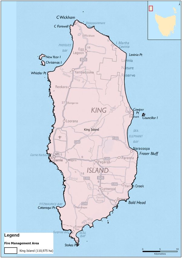
This FMA covers the whole of King Island, an area of 110,975 hectares located at the western entrance
of the Bass Strait, midway between Victoria and mainland Tasmania. Approximately 17% of the island
is public land, managed by Parks and Wildlife Service (PWS) and Sustainable Timber Tasmania (STT).
1,585 people (ABS 2016) occupy the remaining 83% (private/freehold land), serviced by the sole local
government authority on the island, King Island Council.
When considering bushfire as a threat for the community of King Island, the greatest threat comes
from human ignition. Of the bushfires recorded on the island, human ignition has been a common
cause. Since European settlement in the mid 1800’s, fire has been utilised for clearing vegetation for
establishing a successful agricultural industry on the island. As such, it has been estimated that
approximately 70% of the land mass has been modified for agricultural purposes and has subsequently
resulted in the dramatic decline and in some cases elimination of most rainforest and wet forest
vegetation communities and accompanying animal species from areas of the island.
Significant impact from bushfire has historically been faced in the natural landscape with limited
impact identified on human settlement areas. The more significant bushfires recently recorded on the
island, were in 2001 and 2007. These fires burnt extensive tracts of the island’s remaining native
vegetation; with the 2001 bushfire burning approximately 6,000 hectares and the 2007 bushfire
Page 8 of 44
Bushfire Risk Management PlanExecutive Summary
burning approximately 12,500 hectares of native forest, peat (organic soils), pasture, shelter belts and
Ramsar listed wetlands, from Pennys Lagoon in the north to Eldorado Creek in the south, an estimated
70% of the islands native vegetation significantly impacted.
The organic soils (otherwise referred to as ‘Peat’) underlying the pastures on King Island contribute
significantly to the high productivity of the island and are likely to be at least hundreds if not thousands
of years old. Peat or organic leaf matter in soils has both a high economic and environmental value but
can also be an issue for extinguishment following bushfires. Where swamps have been drained for
agricultural purposes or dry out during drought years, peat if exposed to fire can be burnt away and
totally and permanently destroyed. Bushfire poses a risk to peat deposits on King Island.
Bushfire continues to be a major ongoing threat to both the quality and scope of King Island’s
biodiversity. Bushfire is considered to be a major threat to threatened species on King Island.
The remoteness of King Island from mainland Tasmania means that assistance from “off island” in the
form of extra resources and crews that may be required to control a large-scale bushfire on the island
can be logistically challenging. Early recognition of the likely need for assistance together with an early
request for additional resources from off island represents the best opportunity for fast and effective
response to large bushfires on the island. In response to issues faced by the community on King Island
during the 2007 bushfires, a set of criteria have been developed for the TFS, PWS and KIC
representatives to inform decision making and to determine trigger points, where requesting
assistance for bushfire suppression from ‘off island’ resources may occur.
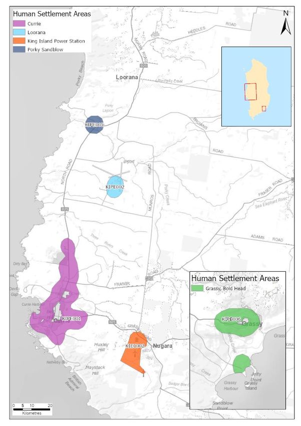
Areas of strategic importance within the King Island Fire Management Area
Reducing fuel loads in strategic locations has the potential to modify fire behaviour and reduce impacts
from bushfires. These areas were identified through a process that utilised and combined local
knowledge/expertise and computer modelling. Fire Management Area Committee members with
specific fire expertise and knowledge across the area contributed to the identification of both the
communities at risk and the broader strategic areas for potential mitigation activities.
The following areas were identified as having strategic importance for the King Island FMA:
Table 1: Areas of strategic importance
Treatment area/Asset Risk Responsible Agency
Currie Human Settlement Bushfires pose a risk to the human settlement area of King Island Council,
Area Currie and associated critical infrastructure supporting PWS and TFS
the community.
Grassy Human Settlement Bushfires pose a risk to the human settlement area of King Island Council,
Area Grassy and associated critical infrastructure PWS and TFS
supporting the community.
Naracoopa Human Bushfires pose a risk to the human settlement area of King Island Council,
Settlement Area Naracoopa and associated critical infrastructure PWS, TFS and STT.
supporting the community.
Colliers Swamp Bushfires pose a risk to threatened ecosystems and PWS
associated individual plant and animal species
Nook Swamp and Lavinia Bushfires pose a risk to threatened ecosystems and PWS
wetlands associated individual plant and animal species
Pegarah Plantation Threatened Ecosystems and associated individual STT
plant and animal species
Economic loss from potential harvest material
Page 9 of 44
Bushfire Risk Management PlanExecutive Summary
Treatment area/Asset Risk Responsible Agency
Critical infrastructure – Bushfires pose a risk to critical infrastructure (through Hydro Tasmania,
communication network, disruption of power) for the King Island community Telstra, King Island
power facilities, water and Council, TasWater and
TAS Ports
transport network.
Existing Strategic fire Access and egress to King Island community and King Island Council,
trails. natural values during the event of a bushfire. PWS, STT and TFS
Page 10 of 44
Bushfire Risk Management PlanIntroduction
1. Introduction
1.1 Background
It is a requirement of Section 20 of the Fire Service Act 1979 that the Fire Management Area Committee
(FMAC) prepare a fire protection plan for its Fire Management Area. This Bushfire Risk Management
Plan (BRMP) fulfils that requirement. The BRMP is submitted to and approved by the State Fire
Management Council (SFMC).
The Fire Service Act 1979 requires that the fire protection plan is consistent with the State fire
protection plan, the Tasmanian Vegetation Fire Management Policy, and because it is an instruction
from SFMC, the Bushfire Risk Management Planning Guidelines (SFMC 2020).
The Bushfire Risk Management Planning Guidelines (BRMPG) explain the framework for bushfire risk
management in Tasmania, the method for doing the risk assessment, and how to prepare the BRMP.
There is very little explanation here in this plan on the rationale, principles and methods used;
therefore, the BRMPG is an important supporting document for understanding this plan.
Under the terms of reference for the King Island FMAC, the purposes of the committee are:
• Provide a forum for communication and collaboration between key stakeholders in the FMA
• Enable a holistic and consistent approach, incorporating local knowledge, to identify strategic
priorities to reduce bushfire risk
• Coordinate efforts and facilitate resource sharing to implement the strategic risk reduction
priorities
• Link the local community and the SFMC through ‘ground-truthing’ the bushfire risk assessment
and mitigation strategies
• Through their advisory function, provide input into decisions and outcomes beyond the Fire
Management Area.
1.2 Purpose of this plan
The management of bushfire-related risk is a collective responsibility of the whole community, with
contributions made by numerous individuals, landowners, and organisations.
An overriding aim of this BRMP is to document a coordinated approach to the identification and
treatment of bushfire risk in the King Island Fire Management Area (FMA). Specific objectives include:
• Guide and coordinate bushfire risk management over a three-year period on all land within the
FMA
• Provide a reference point for the prioritisation and justification of bushfire treatment actions,
as well as supporting evidence for funding requests
• Facilitate the integration of bushfire risk management into the business processes of councils,
organisations, and land managers
• Facilitate cooperation and the coordination of treatment actions between stakeholders
• Clearly and concisely communicate bushfire risk to stakeholders and the community
• Provide a basis for monitoring and reporting of implementation of bushfire risk treatments in
the FMA.
Page 11 of 44
Bushfire Risk Management PlanIntroduction
This BRMP is a strategic-level document that does not provide detail on treatment actions. Individual
organisations and landowners, or collaborative groups, may have developed plans and processes for
implementation of bushfire risk treatment; these can be considered to be linked to the strategic
priorities identified here (SFMC 2020).
Page 12 of 44
Bushfire Risk Management PlanEstablishing the context
2. Establishing the context
2.1 Description of the King Island Fire Management Area
King Island is one of the 334 islands that make up the state of Tasmania. The island is 64km long by
27km wide and lies at the western entrance to the Bass Strait, midway between the state of Victoria
and mainland Tasmania at 144⁰ longitude and 40⁰ latitude. The island is generally quite flat to
undulating, with the highest point being 168m above sea level at Gentle Annie in the south east of the
island. Refer to Map 1 for further locality details.
This Bushfire Risk Management Plan (BRMP) encompasses the whole of King Island with an area of
110,975 ha or 1,095 square kilometres. Approximately 83% of which is considered private land, almost
15% is PWS responsibility and a little over 1% is managed by STT (refer to Table 2 for details). The King
Island Council is the sole local government authority within the FMA. Refer to Map 2 for further FMA
tenure details.
Table 2: Summary of the major tenure land managers in the King Island Fire Management Area
(FMA).
Land manager % of FMA
Private property 83.9
Parks and Wildlife Service reserves 13.1
Sustainable Timbers Tasmania 1.1
Crown land 1.7
2.2 Fire environment
Land use within King Island has been predominantly for purposes of agriculture since European
settlement, with an estimated 70% of native vegetation being removed or modified for agricultural
purposes since European settlement in the late 1800’s.
Remaining native vegetation on the island consists of 28 vegetation communities, with 7 listed as
threatened under the Nature Conservation Act 2002, (36A Spray zone Coastal complex; 6 E.
brookeriana wet forest; 18 E. globulus King Island forest; 18 E. ovata forest and woodland, 30 M.
ericifolia swamp complex, 35 Seabird rockery complexes and Wetland complex). Areas with these
vegetation communities persisting are considered to be of high ecological significance, such as the
Lavinia State Reserve.
Many of the vegetation communities within the FMA are considered to be highly flammable with under
30% of the total land area regarded as ‘treatable’ vegetation, (suitable for fuel reduction planned
burning practices). Although vegetation communities are identified as treatable, current status and
structure of these communities (low surface or near surface fuels and very high to extreme elevated
or canopy fuels are making it increasingly difficult to complete planned burns within prescription). Map
5 provides further details for Vegetation communities identified within FMA.
Page 13 of 44
Bushfire Risk Management PlanEstablishing the context
Table 3: Vegetation Communities and Flammability (Source from LIST Map)
Broad Vegetation Group Veg Flammability % of FMA
Agricultural, urban, and exotic vegetation Medium 63.3
Scrub, heathland, and coastal complexes High – Very High 26.6
Non eucalypt forest and woodland High 2.6
Wet eucalypt forest and woodland Medium 2.8
Dry eucalypt forest and woodland Medium - High 1.0
Other Natural Environments N/A 0.8
Native Grassland High 0.5
Saltmarsh and Wetland Low 0.4
Further detailed descriptions on vegetation communities and associated threatened plant species
residing on the Island, can be sourced from visiting the DPIPWE website at
www.dpipwe.tas.gov.au/tasveg.
Fire practitioners along with key stakeholders have considered the importance of shelter belts on the
island, (narrow rows or belts of trees and shrubs used to provide shelter to stock from wind and also
corridors for native fauna), and the potential for them to act as ‘wicks’ and rapidly carry fire into
adjoining vegetated areas. Shelter belts are highly valued by livestock producers and environmental
groups within the community. To reduce fire spread within these shelter belts, it is recommended that
breaks in the vegetation should be implemented.
Frequent and intense fires over the Island’s European history have eliminated most rainforest and wet
forest associated flora and fauna from areas of the Island (Barnes et al. 2002).
The bushfires experienced in 2001 and 2007 are considered to be the most significant bushfires on the
island in recent times. In 2001, a lightning strike resulted in the Lavinia bushfire burning almost 6,000
hectares of the Lavinia State Reserve, including the devastation of Ramsar Wetland.
In 2007 the Sea Elephant Road bushfire burnt approximately 12,500 hectares of vegetation extending
from Lavinia Point to Sea Elephant Bay. This fire has contributed to a permanent disruption to the
ecology of the island with an estimated 95% of vegetation burnt in the 2001 bushfire, burnt again in
2007. This coupled with extremely dry conditions experienced in 2007, has ensued in a significant loss
of peat and Melaleuca ericifolia swamp forests (RMCD 2007, Corbett & Corbett 2010).
The 2007 (Sea Elephant Road) bushfire was ignited on 18 February 2007 and continued to burn for
three weeks. The fire burnt approximately 12,500 ha from the Sea Elephant Estuary through to Pennys
Lagoon in the north of the Island. It is estimated that 70% of the island’s native vegetation was burnt
during the fire, including areas of internationally recognised Ramsar wetlands and orange bellied
parrot feeding grounds within Lavinia State Reserve and significant tracts of remnant vegetation and
pasture on private property including shelter belts.
Page 14 of 44
Bushfire Risk Management PlanEstablishing the context
When considering the vegetation type, structure, and flammability of the King Island FMA, fires are
largely ‘wind driven’. That is, fires will run with high intensity with the wind, and back very slowly with
medium to low intensity, if not self-extinguish when not influenced by wind. This creates difficulty for
burn practitioner’s planning fuel reduction burns, and successfully completing within prescription.
Peat or organic leaf matter in soils, has both a high economic (supports the nutrient rich agricultural
pastures) and environmental value but can also be an issue for suppression during and post bushfires.
Where swamps have been drained for agricultural purposes or become dry during drought years, the
peat if more readily exposed to fire and may be permanently destroyed.
A summary of the FMA values, concerns and priorities can be drawn from the focus on the protection
of:
• Health and educational facilities including supporting infrastructure, such as childcare facilities,
District School, District Hospital.
• Economic and commercial infrastructure supporting employment/tourism on the island,
including the KI dairy, KI airport, King Island Golf courses (Ocean Dunes, King Island Golf and
Bowling Club, Cape Wickham Golf Links), port infrastructure, Pegarah plantation and agriculture.
• Important natural and cultural values, such as the Lavinia State Reserve or Colliers Swamp
Conservation Area and the associated threatened plant and animal species; Agricultural “Shelter
Belts’, which are considered to be a vital component for successful agriculture on the Island or
Pegarah plantation which has been recognised as possessing endemic rare and threatened
species; and
• Critical communication facilities and supporting infrastructure.
Page 15 of 44
Bushfire Risk Management PlanEstablishing the context
2.3 Climate and bushfire season
The climate of the King Island FMA can be classified as temperate.
The King Island FMA primary Bureau of Meteorology (BOM) weather observation station is located at
King Island Airport, on the western side of the island (Latitude: 39.88° S, Longitude: 143.88°N, Height:
35.0 m), about 5 kilometres north of Currie township.
King Island FMA has a cool to moderate maritime climate heavily influenced by the exposure to the
Southern Ocean and the ‘Roaring 40’s’ with prevailing winds from the west. Although wind direction
during the summer months is highly variable, the most common fire danger weather conditions are
experienced from the north west, refer to Figure 1 for FFDI wind rose.
Mean temperatures (measured from 1962 – 2020) within this FMA range from 7.6°C during the winter
months to 21.3°C in the summer months. The island recorded its hottest day in January of 2013 with
a maximum of 37.8°C and its lowest recorded temperature of -1.2°C in July of 2020. It has been
identified that average temperatures have risen at a rate similar to mainland Tasmania (up to 0.1 C per
decade), since the 1950s, with the daily minimum temperature rising slightly more than daily maximum
temperatures (M Grose 2012, Antarctic Climate and Ecosystems CRC).
The regular westerly frontal systems that cross Tasmania during the winter months, provide the bulk
of the islands rainfall. Although periodic rainfall does occur from the north and east dependant on the
strength of influencing weather patterns, such as the Southern Annular Mode, Indian Ocean Dipole
and El Nino Southern Oscillation.
The bushfire season for King Island is traditionally from November to March, though fires can and do
occur outside this peak season. The bushfire threat for the King Island FMA increases in late December
with January and February generally being the driest and hottest months when bushfires are more
difficult to control.
Autumn is considered to be the preferred and recommended season for fuel reduction planned
burning within King Island, to minimise the risk of organic soils (peat) smouldering and reigniting.
Figure 1: Wind Rose Plot of FFDI – King Island Airport
Page 16 of 44
Bushfire Risk Management PlanEstablishing the context
Figure 1 illustrates the most common FFDI above ‘moderate’, weather conditions recorded for King
Island Airport (Currie) since 1990, and the frequency we can expect those particular conditions to
occur. This wind rose reveals the worst prevailing weather from the NNW.
The graph illustrated in figure 2 below, indicates the likely return period or recurrence of a particular
FFDI for King Island. This information can be utilised to determine what a ‘one in ten year’ fire weather
event may look like for King Islands FMA. The FFDI return period for King Island equates to a FFDI rating
of approximately 36 once every ten years.
Figure 2: FFDI v Annual Exceedance Probability (AEP) – King Island Airport
Climate is changing in Tasmania and it is evident from bushfire climate indicators (Fox-Hughes et al.
2015) that we can expect destructive bushfires to become more frequent.
As per much of the world, climate variability and drought are becoming much more common
occurrences. Since 1981, King Island has experienced all but five years below the long-term
mean annual rainfall (DPIW 2007). Prior to fires in February 2007, King Island has had a
‘serious’ rainfall deficiency for the previous 12, 24 and 36 months, while the annual rainfall
for 2006 was one of the lowest on record (DPIW 2007). (KIWMP 2009, p.3)
Page 17 of 44
Bushfire Risk Management PlanEstablishing the context
2.4 Population and community
A summary of King Island FMA community profile is as follows:
• King Island has an estimated residential population of 1585 people (ABS 2016)
• Approximately 23% of the population are aged 24 or less, with over 50 % of the population aged
between 25 years to 64 years of age, and 22 % of the population aged 65 years or over.
• The Township of Currie is the Islands largest town and administrative centre.
• Agriculture and fishing are the main industries and employers on the island.
• King Island has a strong reputation for its dairy and meat products and has a commercial fishing
fleet for lobster (crayfish) and abalone.
• Public administration and retail trade are the next most significant sources of employment.
Other industries providing employment include mining, kelp harvesting and tourism.
A temporary increase in population may be experienced intermittently, due to transient construction
workers supporting new commercial/infrastructure projects, along with tourists. This may have
potential implications during in an emergency situation.
2.5 Community engagement
The King Island FMAC recognises the importance of the ongoing community liaison and engagement
with DPIPWE, STT, associated specialists, specialist groups along with key stakeholders within the
community, as being an integral component of bushfire management on the island. Community
engagement has and will continue to be centred on individual landowner engagement and immediate
neighbours as part of the planned burn development coordinated by the Bushfire Risk Unit and Parks
and Wildlife. at the time of writing this plan, STT are yet to complete planned burns within STT
managed lands. STT currently focus efforts on preparedness and prevention.
Recent community engagement initiatives have been largely driven by the Bushfire Ready
Neighbourhood program in partnership with the King Island Council, through the delivery of bushfire
preparedness information sessions. These information sessions are supported through regular
attendance of the King Island Show by Parks and Wildlife Service (PWS) and Tasmanian Fire Service
(TFS) representatives from the Fuel Reduction Program, to further discuss and inform decision making
pertaining to mitigation strategies for reducing bushfire risk to members of the community.
Longer-term specific community engagement for the King Island FMA will continue to concentrate on
preparedness through the Bushfire Ready Neighbourhood program in the following areas:
• Loorana
• Naracoopa
• Grassy
• Currie
Bushfire Ready Information sessions provide context around previous and upcoming bushfire seasons,
how TFS responds, situational awareness (FDR and Alerts and Warnings), understanding of Community
Protection Planning, Bushfire survival planning, and preparing individual landowner properties.
The newly developed Red Hot Tips practical bushfire management program will be working towards
facilitating workshops with farmers and landholders in rural areas in 2021/2022. This program aims to
provide landholders with practical advice on effective bushfire mitigations strategies, whilst
empowering the landholder with enhanced skills and abilities to implement these strategies.
Page 18 of 44
Bushfire Risk Management PlanIdentifying the risks
3. Identifying the risks
3.1 Bushfire and impact scenarios
To set the scene for this risk assessment, the bushfire scenarios under consideration are very large
events, typically 10,000 to 20,000 hectares, occurring when fuel dryness and weather conditions
combine to create one or more days of very significant fire weather. Analysis of climate data was used
to determine standard weather events for the scenarios – described as having an Annual Exceedance
Probability of approximately 10% (SFMC 2020).
• A fire breaks out from a campfire, located in the dunes of Lavinia Beach, on a day of FFDI 31, and
ignites adjacent highly flammable vegetation (consisting of rare and threatened plant and animal
species). Weather conditions for the day will be strong north westerly wind stream.
• A fire breaks out from a person cutting firewood through accidental fuel ignition while refuelling
chainsaw, on a day of FFDI 28, and ignites adjacent natural plantation. (Consisting of rare and
threatened plant and animal species and valuable natural and cultivated planation timbers).
Weather conditions for the day will be strong Westerly wind stream.
• A fire breaks out from a powerline arc-flash, located north of Grassy alongside a roadside shelter
belt, on a day of FFDI 37, and ignites adjacent vegetation. Weather conditions for the day will be
strong north westerly wind stream.
Please note, these are not actual scenarios, rather hypothetical agency scenarios for example only.
3.2 Statewide controls
The following controls are currently in place across Tasmania to help manage bushfire-related risk:
• Legislative controls – including Fire Service Act 1979 (e.g. Fire permit period, Total Fire Ban days,
campfires), National Parks and Reserves Management Act 2002 (e.g. fires and campfires),
abatement notices
• TFS public education (e.g. Bushfire Ready Neighbourhoods, media campaigns)
• TFS planning – community protection planning (e.g. Community Response Plans)
• Fuel Reduction Program (TFS, PWS, STT) – funding and coordination of fuel reduction burning
• SFMC programs (e.g. Red Hot Tips training program for fuel reduction burning on private land)
• FMAC – performance monitoring and reporting on this BRMP
• Tasmania Police and TFS – Statewide arson prevention programs
• Land subdivision and building standards (Bushfire-Prone Areas Code, Building Code of Australia)
• Suppression response preparedness – e.g. TFS local volunteer brigades, STT and PWS crews,
forest company crews, fire towers, aircraft, pre-positioning of firefighting resources
• Weather forecasting (Bureau of Meteorology) and fire behaviour prediction (TFS, STT, PWS).
Page 19 of 44
Bushfire Risk Management PlanIdentifying the risks
3.3 Fire Management Area controls
Summary of existing control measures for bushfire within FMA include but are not limited to:
• 4 TFS Brigades, with 52 volunteers and retained brigade response crew available during bushfire
season
• 1 PWS response crew on Island, and Statewide PWS response crews (Statewide rapid attack,
remote area winch capability, seasonal and permanent arrangements) on an availability roster
to respond anywhere within Tasmania.
• Community Protection Planning initiatives through the development of Community Bushfire
Protection Plans and Community Bushfire Response Plans
• Situational awareness during high FDR days, through alerts and warnings to the community.
• Community Engagement programs including, BRN Engagement initiatives, the delivery of
Disaster Resilience Education Tasmania education resources.
• PWS Management Plans
• Fuel Reduction Program throughout key target areas within the FMA – delivered by TFS, PWS
and STT and local Council.
• Ongoing maintenance of scheduled works program completed by Hydro Tasmania, for the
treatment of flammable vegetation within electrical distribution network.
• Annual inspection and maintenance activities of established strategic fire infrastructure within
Parks and Reserves and Crown Land.
Page 20 of 44
Bushfire Risk Management PlanAnalysing and evaluating bushfire risk
4. Analysing and evaluating bushfire risk
4.1 Analysing bushfire risks
A standard risk assessment process was used to determine priorities for this Bushfire Risk Management
Plan (BRMP) following the Tasmanian Emergency Risk Assessment Guidelines and the Bushfire Risk
Management Planning Guidelines 2020 (SFMC 2020), which in summary considers:
• Consequences – what values and assets are at risk given the standard bushfire scenario under
consideration
• Existing controls – how effective the existing controls are at reducing the risk and how much
they are used
• Likelihood – how the likelihood of the consequence occurring is quantified, based on weather,
topography, fuels, and ignition potential
• Confidence level – how certain we are about the evidence and data used
• Risk rating and priority score – calculated by the risk assessment tool (SFMC 2020)
All of the above is recorded in the risk register (Appendix 1).
4.2 Evaluating bushfire risks
The FMAC has identified King Island FMA at risk communities to continue to receive further
engagement initiatives, where fuel reduction mitigation activities may not be permissible due to
variable constraints. Engagement initiatives (such as - Bushfire Ready Neighbourhood program, Fuel
Reduction Program and the Red Hot Tips programs), will promote preparedness and an overall
behavioural change to fire mitigation techniques within the landscape.
Critical infrastructure and supporting network facilities for communication, power, water and
transport corridors, (e.g. King Island Advanced Hybrid Power Station; Gentle Annie, Counsel Hill and
Tower Hill Communication facilities), have been identified for priority actioning to review bushfire risk,
where practically possible and implement bushfire mitigation measures as required.
The FMAC has identified a need for responsible agencies to complete further analysis and/or develop
strategic bushfire mitigation plans within the predetermined bushfire management zones identified
within the treatment plan (Appendix 2) for human settlement areas bounded by vegetation
communities not conducive with planned burning practices, (Grassy, Currie and Naracoopa). Further
detailed analysis may follow should key stakeholders determine local mitigation plans be required.
The Pegarah plantation will continue to receive strategic enhancement of strategic fire trails within the
land parcel and review tactical plan.
Environmental values (Colliers Swamp, Nook Swamp and Lavinia Wetlands, threatened flora and fauna
species) have been evaluated with consideration to vulnerability to bushfire and relative impact. These
values will be targeted for treatment, further analysis or monitor and review, primarily by PWS for
protection through the strategic application of fuel reduction planned burning, along with the adoption
and implementation of strategic bushfire mitigation tactics.
Further details of the key risks identified within the FMAC can be sources from risk register (Appendix
1).
Page 21 of 44
Bushfire Risk Management PlanBushfire risk treatment
5. Bushfire risk treatment
5.1 Treatment plan
The Fire Management Area Committee (FMAC) considered the costs, benefits, practicalities, and
environmental impacts of various control options for the highest priority risks. The risk treatments that
were determined from these deliberations are recorded in the treatment plan (Appendix 2).
Individual landowners and organisations are usually responsible for implementing the treatments;
these are indicated in the treatment plan. One exception is fuel reduction burning that is planned and
conducted by the Fuel Reduction Program (TFS, PWS, STT) with the agreement of landowners.
Community education and preparedness coupled with the implementation of strategic bushfire
mitigation strategies will be key to sustainable bushfire risk reduction for the King Island community.
The FMAC has identified an importance to further enhance response planning for highly threatened
ecosystems and natural values at risk from bushfire (refer to treatment plan (Appendix 2) for details),
such as:
• Colliers Swamp Conservation Area
• Nook Swamp & Lavinia Wetlands within Lavinia State Reserve, and
• Pegarah Plantation.
Critical infrastructure and supporting network facilities for the King Island community, have been
identified for priority actioning for ongoing support, monitoring and review, to ensure bushfire
mitigation is adhered and support provided when applicable.
Due to complexities for fuel reduction burning on the island, fuel management buffer zones (FMBZ’s)
and strategic fire trails (SFT) are considered a desirable alternative, where fuel reduction burning is not
conducive with particular vegetation type. The towns of Currie and Grassy, require priority actioning
for review and implementation in order to provide further protection and aid in suppression efforts.
5.2 Bushfire management zones
For those assets and values where fuel management or other treatments are designated in the
treatment plan (Appendix 2), bushfire management zones are used to delineate the treatment areas.
It is anticipated that bushfire management zones will be identified through the development and
enhancement of strategic bushfire mitigation plans by key stakeholders or local mitigation plans should
the responsible agency deem it necessary. Priority assets which require development of said plans are
identified in the treatment plan (Appendix 2).
The names of zones and descriptors are provided in Appendix 3.
Page 22 of 44
Bushfire Risk Management PlanBushfire risk treatment
5.3 Implementing treatments
This Bushfire Risk Management Plan (BRMP) does not guarantee a source of funding for treatment
actions, nor does it provide a process for seeking funding. The organisations and individuals that are
responsible for delivering the bushfire risk treatments are responsible for developing further plans for
implementation, as well as arranging resources and funding.
The BRMP is, however, intended to provide evidence and justification for where funding and resources
are most appropriate to be committed by stakeholders to mitigate bushfire risk.
Many treatments identified in this plan will require environmental and cultural impact assessment.
These assessments are the responsibility of the individual organisations and are not covered by this
BRMP.
From the inception of the Fuel Reduction Program within the FMA, the successful implementation of
tactical fire mitigation strategies has been limited or in some cases halted due to various factors
outside the practitioner’s control, such as:
• Lack of funding for maintenance or establishment of Strategic Fire Trails, Fuel Management
Buffer Zones or other mechanical mitigation activities located on private and public lands, for
local council and private landholders.
• Limitations on fire mitigation strategies within vegetation communities not suitable for planned
burning practices.
• Shifting climatic conditions, which are shortening windows for planned burning.
• Community perception and understanding of ‘treatable’ and ‘untreatable’ vegetation, and
awareness of vegetation that may or may not be suitable for planned burning within
prescriptions.
• Lack of funding for enhanced protection of critical assets and supporting infrastructure.
• Lack of capacity of some of the community to adhere to abatement notices issued by local
Council.
• Lack of resourcing on the island to complete maintenance of mechanical bushfire mitigation
activities.
• Difficulty in resourcing of planned burning activities. Key land management agencies regularly
compete for human and mechanical resources for planned burn activities.
5.4 Strategic fire infrastructure
Strategic fire infrastructure includes access roads, fire trails, tracks, and water sources.
Strategic fire trails in the King Island FMA are listed in strategic fire infrastructure (Appendix 4). These
fire trails are designated because they are essential for fuel reduction and bushfire suppression; they
should be regularly maintained to appropriate standards.
A detailed analysis of potential fire trails was completed in the 2009 King Island Wildfire Management
Plan. Of the 38 identified fire trails/tracks, only a select few strategic trails have received adequate
maintenance for bushfire mitigation. In line with, bushfire management areas identified in Section 5.2,
TFS along with with PWS, King Island Council and other key stakeholders, will collaboratively develop
localised mitigation strategies in order to enhance the effectiveness of identified strategic fire
infrastructures.
Page 23 of 44
Bushfire Risk Management PlanBushfire risk treatment
Approved water sources for firefighting purposes include:
• Naracoopa (Kibuka Dam)
• Sea Elephant River (x2)
• Counsel Hill fire trails (end of Rekara road)
• Nook Swamp
• Main Lavinia fire trail (Youngs road)
• Lake Flannigan track
5.5 Fuel reduction burning
The Strategic Fire Management Zones (SFMZ) delineate general areas for treatment by fuel reduction
burning. Individual burn units are not identified in this BRMP, but will need to be identified within the
SFMZ by further planning from the organisations responsible for carrying out the fuel reduction
burning.
There are many kinds of vegetation for which it is not appropriate or practical to conduct fuel reduction
burning (SFMC 2020); these vegetation communities are described as ‘untreatable’ and indicated on
Map 4. The broad vegetation communities within the FMA can be seen on Map 5.
The Fuel Reduction Program that is funded, coordinated and implemented by the Tasmania Fire
Service, Parks and Wildlife Service and Sustainable Timbers Tasmania is undertaken on behalf of and
with the agreement of individual landowners or organisations (e.g. councils). The priorities of the Fuel
Reduction Program are guided by the priorities identified in the treatment plans across all Fire
Management Areas.
Page 24 of 44
Bushfire Risk Management PlanMonitoring and review
6. Monitoring and review
6.1 Review
This Bushfire Risk Management Plan (BRMP), including appendices and maps, will be subject to a
comprehensive review every three (3) years from the date of approval, unless significant
circumstances exist to warrant earlier review. The revised BRMP will be based on a new risk
assessment that may include revised input methods. The review process will include examination of:
• changes to the Fire Management Area (FMA), organisational responsibilities or legislation
• changes to the bushfire risk in the area
• major bushfire events
• shortcomings in data that can be improved
• change of usage of the area
• new or changed asset values within the FMA
Additional and changed data and values (both community and natural) identified by the review process
will be supplied to the Bushfire Risk Unit (TFS) for inclusion in ongoing risk modelling being carried out
at the state level.
6.2 Monitoring and reporting
Progress towards completion of the treatments proposed will be monitored and reviewed twice a year
by the Fire Management Area Committee (FMAC); this will be documented in the Implementation
Status Report which should address as a minimum:
• progress on implementation of treatments listed in the treatment plan, including
• planning outcomes including mitigation plans, community protection plans, community
response plans
• implementation progress of community programs
• completed fuel reduction burns
• development and maintenance of Asset Protection Zones (APZ)
• development and maintenance of strategic fire infrastructure
At a Statewide level, the State Fire Management Council will examine the impacts of the strategic
burning program on risk management as part of the strategic fuel management program.
Page 25 of 44
Bushfire Risk Management PlanReferences
References
Fox-Hughes, P., Harris, R.M.B., Lee, G., Jabour, J., Grose, M.R., Remenyi, T.A. and Bindoff, N.L. (2015).
Climate Futures for Tasmania future fire danger: the summary and the technical report, Antarctic
Climate & Ecosystems Cooperative Research Centre, Hobart, Tasmania. Retrieved from
http://acecrc.org.au/wp-content/uploads/2015/12/Report_CFT_Future-Fire-Technical-
Report_2015_web.pdf.
King Island Fire Management Area Committee (2009), King Island Wildfire Management Plan.
Department of Primary Industries, Parks, Water and Environment.
SFMC (2020), Bushfire Risk Management Planning Guidelines, State Fire Management Council,
Tasmania. Retrieved from
http://www.sfmc.tas.gov.au/sites/sfmc.tas.gov.au/files/Bushfire%20Risk%20Management%20Planni
ng%20Guidelines%202020.pdf
TERAG (2017), Tasmanian Emergency Risk Assessment Guidelines. Department of Police, Fire and
Emergency Management, Tasmania. Retrieved from http://www.ses.tas.gov.au/about/risk-
management/terag/
Threatened Species Section (2012), King Island Biodiversity Management Plan. Department of
Primary Industries, Parks, Water and Environment, Hobart.
Page 26 of 44
Bushfire Risk Management PlanAppendices
Appendices
Appendix 1: Risk Register
Notes at the end of the risk register provide explanation for the TERAG code, Asset description and Priority FMAC columns.
TERAG Asset Asset description (risk Consequence Controls Confidence Combined Risk level Priority Treatment LGA
code category statement) effectiveness likelihood FMAC options
KIPU002 Critical Grassy water catchment area Major Low Moderate Rare High 8 Monitor and King Island
Infrastructure review
KIPU001 Critical Counsel Hill communications Moderate Low Moderate Unlikely Medium 11 Monitor and King Island
Infrastructure towers review
KIEC002 Critical King Island Power Station Major Medium Highest Rare High 19 Monitor and King Island
Infrastructure review
KIPU004 Critical Tower Hill communications Moderate Medium Moderate Rare Medium 19 Further analysis King Island
Infrastructure towers
KIPU003 Critical Gentle Annie communications Moderate Medium Moderate Very Rare Low 32 Monitor and King Island
Infrastructure towers review
KISO002 Human Grassy, Bold Head Major Very Low Highest Unlikely High 16 Treatment King Island
Settlement
Area
KIPE001 Human Currie Moderate Very Low Highest Unlikely Medium 29 Treatment King Island
Settlement
Area
KIPE006 Human Grassy, Bold Head Moderate Very Low Highest Unlikely Medium 29 Treatment King Island
Settlement
Area
KIPE002 Human Loorana Insignificant Low Highest Rare Very Low Further analysis King Island
Settlement
Area
KIPE003 Human Naracoopa Minor Very Low Highest Rare Low Further analysis King Island
Settlement
Area
KISO001 Human Naracoopa Moderate Very Low Highest Rare Medium Further analysis King Island
Settlement
Area
Page 27 of 44
Bushfire Risk Management PlanAppendices
TERAG Asset Asset description (risk Consequence Controls Confidence Combined Risk level Priority Treatment LGA
code category statement) effectiveness likelihood FMAC options
KIPE005 Human Porky Sandblow Minor Very Low Highest Rare Low Further analysis King Island
Settlement
Area
KIEN014 Natural Value Acanthornis, Austrochloritis, Catastrophic Low Highest Unlikely Extreme 3 Treatment King Island
King, Melaleuca
KIEN003 Natural Value Acanthornis, King Catastrophic Low Highest Unlikely Extreme 3 Treatment King Island
KIEN001 Natural Value Pneumatopteris Major Very Low Highest Unlikely High 11 Treatment King Island
KIEN002 Natural Value Pneumatopteris Major Very Low Highest Unlikely High 13 Further analysis King Island
KIEN004 Natural Value King Minor Very Low Highest Rare Low Further analysis King Island
KIEN005 Natural Value King Minor Very Low Highest Rare Low Further analysis King Island
KIEN006 Natural Value King Minor Very Low Highest Unlikely Low Treatment King Island
KIEN007 Natural Value King Minor Very Low Highest Very Rare Very Low Further analysis King Island
KIEN008 Natural Value King Minor Very Low Highest Rare Low Further analysis King Island
KIEN009 Natural Value King Minor Very Low Highest Unlikely Low Further analysis King Island
KIEN010 Natural Value King Minor Very Low Highest Very Rare Very Low Further analysis King Island
KIEN011 Natural Value King Minor Very Low Highest Unlikely Low Further analysis King Island
KIEN012 Natural Value King Minor Very Low Highest Rare Low Further analysis King Island
KIEN013 Natural Value King Minor Very Low Highest Very Rare Very Low Further analysis King Island
KIEN015 Natural Value King Minor Very Low Highest Unlikely Low Further analysis King Island
KIEN016 Natural Value King Minor Very Low Highest Unlikely Low Further analysis King Island
KIEN017 Natural Value King Minor Very Low Highest Rare Low Further analysis King Island
KIEN018 Natural Value King Minor Very Low Highest Very Rare Very Low Further analysis King Island
KIEN019 Natural Value King Minor Very Low Highest Rare Low Further analysis King Island
KIEN020 Natural Value King Minor Very Low Highest Very Rare Very Low Further analysis King Island
KIEN021 Natural Value King Minor Very Low Highest Unlikely Low Further analysis King Island
KIEN022 Natural Value King Minor Very Low Highest Unlikely Low Further analysis King Island
KIEN023 Natural Value King Minor Very Low Highest Very Rare Very Low Further analysis King Island
KIEN024 Natural Value King Minor Very Low Highest Rare Low Further analysis King Island
KIEC001 Production Cluster of various coupes & Major Low Highest Unlikely High 11 Treatment King Island
Forest plantations
Page 28 of 44
Bushfire Risk Management PlanYou can also read