Human Discovery and Settlement of the Remote Easter Island (SE Pacific) - MDPI
←
→
Page content transcription
If your browser does not render page correctly, please read the page content below
quaternary

Review
Human Discovery and Settlement of the Remote
Easter Island (SE Pacific)
Valentí Rull
 Laboratory of Paleoecology, Institute of Earth Sciences Jaume Almera (ICTJA-CSIC), C. Solé i Sabarís s/n,
 08028 Barcelona, Spain; vrull@ictja.csic.es

 Received: 19 March 2019; Accepted: 27 March 2019; Published: 2 April 2019

 Abstract: The discovery and settlement of the tiny and remote Easter Island (Rapa Nui) has
 been a classical controversy for decades. Present-day aboriginal people and their culture are
 undoubtedly of Polynesian origin, but it has been debated whether Native Americans discovered
 the island before the Polynesian settlement. Until recently, the paradigm was that Easter Island
 was discovered and settled just once by Polynesians in their millennial-scale eastward migration
 across the Pacific. However, the evidence for cultivation and consumption of an American plant—the
 sweet potato (Ipomoea batatas)—on the island before the European contact (1722 CE), even prior
 to the Europe-America contact (1492 CE), revived controversy. This paper reviews the classical
 archaeological, ethnological and paleoecological literature on the subject and summarizes the
 information into four main hypotheses to explain the sweet potato enigma: the long-distance
 dispersal hypothesis, the back-and-forth hypothesis, the Heyerdahl hypothesis, and the newcomers
 hypothesis. These hypotheses are evaluated in light of the more recent evidence (last decade),
 including molecular DNA phylogeny and phylogeography of humans and associated plants and
 animals, physical anthropology (craniometry and dietary analysis), and new paleoecological findings.
 It is concluded that, with the available evidence, none of the former hypotheses may be rejected
 and, therefore, all possibilities remain open. For future work, it is recommended to use the multiple
 working hypotheses framework and the strong inference method of hypothesis testing, rather than
 the ruling theory approach, very common in Easter Island research.

 Keywords: islands; discovery; settlement; colonization; Easter Island; Rapa Nui; Pacific Ocean;
 Polynesians; Native Americans

1. Introduction
     Due to their remoteness and physical isolation, oceanic islands are particularly well suited to
study discovery and settlement processes [1]. Easter Island, located in the South Pacific, has been
included among the most remote inhabited places on Earth (Figure 1). This, together with its more
or less intermediate position between the Polynesian Pacific archipelagos and the South American
continent, of contrasting cultural traits, has fostered the interest on when, how, and by whom this tiny
island was discovered and initially settled and whether it has experienced significant cultural turnover
since then [2–5].
     This paper briefly reviews the classical literature on the subject to present the main hypotheses
that have been erected and the archaeological, ethnological, and paleoecological evidence used to test
them. The paradigmatic outcomes of these studies are then checked against new multidisciplinary
evidence collected during the last decade, including genomics, the results of which have challenged
and/or enriched former views. The focus is on the discovery and settlement phases and, eventually,
on the occasional occupancy between these two events. Postsettlement cultural developments and their
possible drivers have already been reviewed by the author elsewhere [6,7]. Finally, it is recommended

Quaternary 2019, 2, 15; doi:10.3390/quat2020015                              www.mdpi.com/journal/quaternary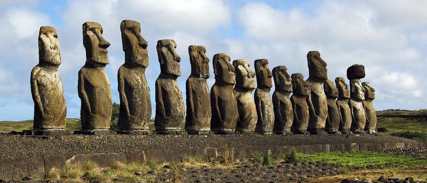
Quaternary 2019, 2, 15 2 of 16
Quaternary 2019, 2, x FOR PEER R EVIEW 2 of 16
that further
Finally, it is studies adopt athat
recommended multiple
furtherworking
studies hypotheses framework
adopt a multiple combined
working with framework
hypotheses the strong
inference method of hypothesis testing to adequately tackle the inherent complexity of the topic
combined with the strong inference method of hypothesis testing to adequately tackle the inherent under
study [8]. of the topic under study [8].
complexity
Figure 1.
Figure 1. General
General map of the Pacific Ocean with indication of the main archipelagos including those
mentioned in the text. Easter Island (EI)(EI) is
is displayed
displayed asas a red dot and some significant islands in the
of this
context of thispaper
paperare
arehighlighted
highlightedasasblue
blue dots
dots (M – Mangareva;
(M–Mangareva; R – Iti;
R–Rapa Rapa Iti; T –The
T–Tahiti). Tahiti). The
distance
between
distance Easter
betweenIsland and
Easter someand
Island relevant
some islands
relevantisislands
expressed in km [3].in km [3].
is expressed
2.
2. The Island Today
The Island Today
Easter
Easter Island
Island isis called
called RapaRapa NuiNui by by itsits aboriginal
aboriginal inhabitants,
inhabitants, the the Rapanui.
Rapanui. TheThe name
name Easter
Easter
Island (Paasch Eyland, in Dutch) was coined by the first Europeans who
Island (Paasch Eyland, in Dutch) was coined by the first Europeans who arrived to the island, arrived to the island, a Dutcha
expedition commanded
Dutch expedition commanded by Jacob byRoggeveen,
Jacob Roggeveen, on Easter Sunday
on Easter (5th April)
Sunday of 1722.
(5th April) of The
1722.name Rapa
The name
Nui
Rapa Nui (Big Rapa) originated later in the 1860s, and was used by the Tahitian sailors the
(Big Rapa) originated later in the 1860s, and was used by the Tahitian sailors to differentiate to
island from athe
differentiate smaller
islandone from called Rapa (now
a smaller one calledRapa Rapa
Iti, meaning
(now RapaSmall Iti,Rapa) (Figure
meaning 1). Rapa)
Small According to
( Figure
the indigenous to
1). According tradition, the first name
the indigenous of thethe
tradition, island
firstwas
namePito-o-te-Henua
of the island (the wasNavel of the World(the
Pito-o-te-Henua or
the End of the World, depending on the source) but this term is rarely used.
Navel of the World or the End of the World, depending on the source) but this term is rarely used. In In Spanish—the official
Chilean language
Spanish—the (theChilean
official island belongs
language to (the
Chile sincebelongs
island 1888)—the namesince
to Chile is Isla de Pascua.name
1888)—the Easter Island
is Isla de
is very small 2
Pascua. Easter(164 km is) and
Island veryofsmall
triangular
(164 km shape,
2) andowing to the coalescence
of triangular shape, owing of three
to thevolcanic cones:
coalescence of
Terevaka (the highest
three volcanic cones: elevation
Terevaka of (thethehighest
island with 511 m),
elevation Poike,
of the andwith
island Kao 511
(Figure
m), 2). The and
Poike, island is
Kao
located ◦ 0 00 ◦ 0 00
(Figure at
2).about 27 07 is
The island 09located
S and at109about
21 2927ºW, 07’more
09” Sthan
and2000
109ºkm21’apart
29” W, from thethan
more nearest
2000Polynesian
km apart
islands (Picairn) and >3500 km far from the South American Pacific coasts
from the nearest Polynesian islands (Picairn) and >3500 km far from the South American Pacific (Figure 1).
coasts (Figure 1).
Quaternary 2019, 2, 15 3 of 16
Quaternary 2019, 2, x FOR PEER R EVIEW 3 of 16
2. Google
Figure 2.
Figure Earth view
Google Earth view of
of Easter
Easter Island
Island indicating
indicating the
the main
main features
features mentioned
mentioned in
in the
the text.
text.
The climate
The climate is is subtropical
subtropical oceanic oceanic with
with annual
annual average
average temperatures
temperatures of 20–21 ◦°C
of 20–21 C andand small
small
seasonal ◦
seasonal variations (2–3 °C). Total annual precipitation is 1200 mm on average, with a more humid
variations (2–3 C). Total annual precipitation is 1200 mm on average, with a more humid
period
period between
between April April andand JuneJune (120–140
(120–140 mm/month)
mm/month) and and aa drier
drier phase
phase between
between November
November and and
January (70–90 mm/month). There are no permanent water
January (70–90 mm/month). There are no permanent water courses on the island due to courses on the island due to the
the high
high
porosity
porosity of of its
its volcanic
volcanic rocks;
rocks; the theonly
onlyfreshwater
freshwaterreservoirs
reservoirsare arethe
theranos,
ranos, anan indigenous
indigenous name
name to
to designate a volcanic crater with permanent water inside, in the
designate a volcanic crater with permanent water inside, in the form of a lake or a marsh [9]. The form of a lake or a marsh [9].
The biggest
biggest one isoneRanois Rano
Kao, Kao,
with with
a lakeaoflake
>1 kmof >1 km diameter
diameter and ca.and 10 m ca.depth,
10 m followed
depth, followed
by Ranoby Rano
Raraku
Raraku (300 m diameter
(300 m diameter and up to and3 mup to 3 m
depth) depth)
and Ranoand Aroi, Rano
withAroi,
a marshwithofa ca.
marsh
150 m of diameter
ca. 150 m( Figure
diameter 3).
(Figure 3).
The vegetation is entirely anthropogenic and dominated by grasslands (85–90% of the surface),
forestThe
andvegetation
shrublands is are
entirely
scareanthropogenic
(5% each), andand ~1%dominated
corresponds bytograsslands
crops and (85–90% of the surface),
ruderal vegetation [10].
forest and shrublands are scare (5% each), and ~1% corresponds to crops
The flora is not very rich and most species are introduced. Indeed, of the >200 species of vascular and ruderal vegetation [10].
The flora is not very rich and most species are introduced. Indeed,
plants known, less than a quarter are autochthonous and only four are endemic to the island [11]. of the >200 species of vascular
plants known,contrasts
This situation less thanwith a quarter are autochthonous
palynological reconstructionsand only four are
that have endemic to
documented anthe island
island [11].
mostly
This situation
covered by dense contrasts with palynological
and extensive palm-dominatedreconstructions that have
forests during documented
the last ~40 kyr BP an[12–14].
island mostly
These
covered by dense and extensive palm-dominated forests during the
forests would have been totally removed in 1400–1600 CE by Polynesian colonizers, the fruit eating last ~40 kyr BP [12–14]. These
forests
rats theywould have been
introduced totally
to the removed
island, or both in [3,15,16].
1400–1600This CE byhasPolynesian
been interpretedcolonizers,
as thetheresult
fruit eating
of the
rats
overexploitation of the Island’s natural resources and the main cause of the cultural collapse of
they introduced to the island, or both [3,15,16]. This has been interpreted as the result of the
the
overexploitation
ancient Rapanui civilization [3], which has been considered a microcosmic model for the futurethe
of the Island’s natural resources and the main cause of the cultural collapse of of
ancient Rapanui civilization [3], which has been considered a microcosmic
the entire planet under the current exploitation practices [17]. This ecocidal hypothesis has been model for the future of
the entire planet
paradigmatic under the
for decades butcurrent
furtherexploitation
studies havepractices
challenged [17].
thisThis
view ecocidal
[5,16,18hypothesis
–20]. has been
paradigmatic for decades but further studies have challenged this view
At present, Easter Island has about 6000 inhabitants, most of them living on the capital, Hanga [5,16,18–20].
Roa. At present, Easter
Approximately 40%Islandof thehaspopulation
about 6000isinhabitants,
consideredmost to beofofthem living on
Polynesian the capital,
origin and 60% Hanga
is of
Roa. Approximately 40% of the population is considered to be
Chilean origin, although the intense mixing between these two ethnic groups prevents to defineof Polynesian origin and 60% is ofa
Chilean origin, although
clear separation betweenthe intense
them. Themixing between
indigenous these two
language of ethnic
Rapa Nui groups prevents
is called to define
vananga anda clear
is of
separation between them. The indigenous language of Rapa Nui is called vananga
Polynesian origin, but is restricted to this island. The different cultures that have established on the and is of Polynesian
origin, but isinfluenced
island have restricted the to this island.
original The different
vananga, which cultures that havefrom
has contribution established on the island
several languages, have
notably
influenced the original
English, French, Spanish, vananga,
and Tahitianwhich[21].
has contribution from several languages, notably English,
French, Spanish, and Tahitian [21].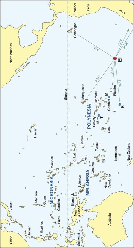
Quaternary 2019, 2, 15 4 of 16
Quaternary 2019, 2, x FOR PEER R EVIEW 4 of 16
Quaternary 2019, 2, x FOR PEER R EVIEW 4 of 16
Figure 3. The
Figure three
3. The permanent
three permanentwaterbodies ofEaster
waterbodies of EasterIsland.
Island. Photos:
Photos: V. Rull.
V. Rull.
The The
island Figure
holds an3.anThe three permanent
impressive waterbodies offrom
Easter the
Island. Photos:Rapanui
V. Rull.
island holds impressivecultural
cultural heritage
heritage from the ancient
ancient civilization
Rapanui civilization that, that,
according
according to the ecocidal paradigm, caused the socioecological demise of the island. The most iconicmost
to the ecocidal paradigm, caused the socioecological demise of the island. The
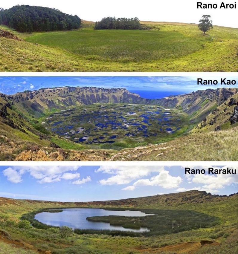
The island holds an impressive cultural heritage from the ancient Rapanui civilization that,
iconicmanifestations
manifestations of disappeared
of this this disappeared civilization
civilization aremegalithic
are the >950 the >950 statues,
megalithiccalledstatues, called
moai (Figure 4),moai
according to the ecocidal paradigm, caused the socioecological demise of the island. The most iconic
carved
(Figure 4), on the soft
carved on volcanic
the soft rocks (tuff)
volcanic of the
rocks Raraku
(tuff) of crater
the and transported,
Raraku crater and by unknown methods,
transported, by unknown
manifestations of this disappeared civilization are the >950 megalithic statues, called moai (Figure 4),
to almost all island’s
methods, coasts [22]. However this is not thethis
onlyislegacy of that enigmatic civilization, as
carvedtoonalmost
the softall island’s
volcanic coasts
rocks (tuff)[22].
of theHowever
Raraku crater and not the only
transported, bylegacy of that
unknown enigmatic
methods,
it has
civilization, been
asall estimated
it island’s
has been that a total
estimated of ~20,000
that a totalsites and/or
ofnot
~20,000manifestations
sites and/or (in an island
manifestations of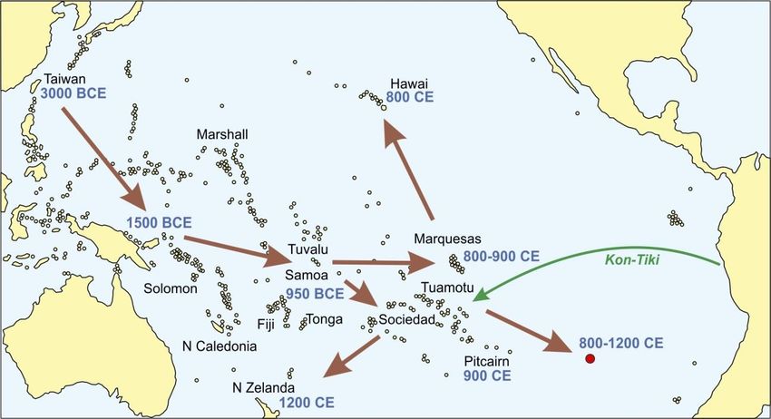
Quaternary 2019, 2, 15                                                                               5 of 16

3. The East–West Debate
      The intermediate position of Easter Island between South America, to the East, and Polynesia,
to the West, has fostered a controversy on the geographical origin of Easter Island’s discoverers and
settlers from either one or another side of the Pacific Ocean. A brief historical account is provided
to the following on how this debate has proceeded using mainly ethnological and archaeological
evidence. More extensive and detailed reviews are available elsewhere [2–5,24–27].

3.1. Rapanui Mythology
      The first hypothesis on the origin of the Rapanui civilization emerged from Rapanui’s oral tradition
and, hence, it should be taken with great care [3]. According to the Rapanui legend, the founders
of this civilization arrived from the west by boat and landed at Anakena beach (Figure 2). These
pioneers were commanded by Hotu Matu’a and their homeland was a hypothetical Polynesian island
called Hiva. These first colonizers brought all what they needed to settle the island (food, tools, plants,
and animals) and settled near Rano Raraku, from where they spread across the island. This legend does
not specify a particular chronology for the arrival of the Polynesian settlers. As any legend based on
oral tradition, there are several versions and a variable set of details according to the person who tells
the story but there is a general agreement in the geographical origin. On the basis of the Rapanui oral
tradition, earlier Easter Island ethnologists, such as Katherine Routledge or Alfred Métraux, located the
legendary island of Hiva in the Marquesas Islands or in the Gambier Islands, specifically on an island
called Mangareva (Figure 1) [24,25]. It should also be noted that modern Rapanui have an indisputable
Polynesian origin and, hence, they refer to the origin of their own culture. In the Rapanui mythology,
Hotu Matu’a and their followers were both the discoverers and the first settlers of Easter Island.

3.2. South American Origins
     In 1803, the Spanish missionary Joaquín de Zúñiga suggested that the predominant winds and
marine currents seamed favorable for navigating from South America to Polynesia. During the
same century, several analogies were established between the Easter Island statues and those from
Native American cultures of Bolivia and Peru [3]. These observations encouraged the Norwegian
explorer Thor Heyerdahl to demonstrate that Easter Island was first discovered by Native Americans,
before the arrival of the Polynesian culture that founded the Rapanui civilization. The famous Kon-Tiki
expedition was launched for this purpose in 1947. Using a simple raft with a single sail, Heyerdahl
and five other men navigated from Peru to the Tuamotu Islands in 101 days (Figure 5) with only the
aid of the winds and the marine currents, thus supporting the hypothesis of Zúñiga [28]. Heyerdahl
concluded that Easter Island would have been discovered in this way by Native American cultures and
organized a fieldwork campaign (1955–1956) to the island to collect evidence in support of this idea.
He found, for example, that some plants (notably the sweet potato; Ipomoea batatas) were considered to
be introduced from South America and their names (kumara, in the case of sweet potato) were also of
Native American origin. He also noted similarities between many tools and constructions, including
the moai and some petroglyph representations, with potential Incaic and pre-Incaic counterparts from
South America [29].
     The underlying hypothesis of Heyerdahl was that Native Americans were the discoverers of Easter
Island by 400 CE and the Polynesians arrived later and eradicated the Amerindian culture. Heyerdahl
linked this view with a Rapanui legend about a war between two groups called the “short-ears” and
the “long-ears”, where the first won and exterminate the enemies. The chronology was based on a
single radiocarbon date and was called in question later and considered too old [30]. The scientific
community did not take Heyerdahl’s ideas too seriously arguing that he was so attached to his theories
that he was neither objective nor rigorous in the analysis of evidence [3]. Perhaps the main merit of
Heyerdahl was that, for the first time, he disentangled discovery from settlement, in a cultural sense,
Quaternary 2019, 2, x FOR PEER R EVIEW 6 of 16
Quaternary 2019, 2, 15 6 of 16
attached to his theories that he was neither objective nor rigorous in the analysis of evidence [3].
Perhaps the main merit of Heyerdahl was that, for the first time, he disentangled discovery from
and introduced the possibility of arrival and interaction of both Polynesian and Amerindian cultures
settlement, in a cultural sense, and introduced the possibility of arrival and interaction of both
on Easter Island.
Polynesian and Amerindian cultures on Easter Island.
Figure 5. Peopling of the Pacific from East Asia, according to Kirch [31]. The green arrow is the
Figure 5. Peopling of the Pacific from East Asia, according to Kirch [31]. The green arrow is the
approximate trajectory of the Kon-Tiki experition [28].
approximate trajectory of the Kon-Tiki experition [28].
3.3. Polynesian Origins
3.3. Polynesian Origins
Most evidence provided by Heyerdahl to defend his theory of Native American discovery was
Most evidence
reanalyzed by Flenley provided
and Bahn by[3]
Heyerdahl
to supportto thedefend
contrary hishypothesis,
theory of Native
that is,American discovery
the Polynesian was
discovery
reanalyzed
and settlement, by Flenley
coinciding andwith
Bahn the[3] to support
Rapanui legend.theThese
contrary hypothesis,
authors highlightedthat that
is, the
the Polynesian
winds and
discovery and settlement, coinciding with the Rapanui legend. These
currents that favor the East–West navigation are not constant but vary seasonally. They also noted authors highlighted that that
the
winds and currents that favor the East–West navigation are not constant
the “El Niño” phenomenon, which occurs every four years, stops or reverts the oceanic circulation but vary seasonally. They
also noted that
thus favoring the “El navigation.
West–East Niño” phenomenon,
Furthermore, which occurs skills
navigation everywere
fourveryyears, stops atorboth
different reverts
sidesthe
of
oceanic circulation thus favoring West–East navigation. Furthermore,
Easter Island. Polynesians were experienced sailors who have colonized most of the Pacific islands andnavigation skills were very
different
archipelagosat both sides of in
for millennia Easter Island. direction
a West–East Polynesians (seewere
below). experienced
Their boatssailors who have
were highly colonized
hydrodynamic
most of the
and very Pacificand
efficient islands
couldand archipelagos
be moved by wind forand
millennia
oars, very in adifferent
West–East direction
to the (see below).
rudimentary Their
Heyerdahl’s
boats were
Kon-Tiki raft. highly hydrodynamic and very efficient and could be moved by wind and oars, very
different to the rudimentary
Regarding plants of South Heyerdahl’s
American Kon-Tiki
origin andraft. their names, these would have been introduced
after the European contact. According to Flenley and Bahn names,
Regarding plants of South American origin and their [3], the these
Rapanuiwould have
art can been
also be introduced
considered
after the European contact. According to Flenley and Bahn
of Polynesian origin. For example, the moai and the tools used for their carving may be [3], the Rapanui art canrelated
also be to
considered of Polynesian
similar representations fromorigin. For example,
Mangareva the moai and
(the hypothetical Hiva the
of tools used forlegend,
the Rapanui their carving
see above)mayand be
related
adjacenttoislands.
similar representations
The same is true from Mangareva
for the petroglyphs,(the hypothetical
whose images Hivaareofcommon
the Rapanui legend,
in other see
Pacific
above) and adjacent islands. The same is true for the petroglyphs,
island, for example, Hawaii or New Zealand. Other evidence come from physical anthropology, whose images are common in
other Pacificfrom
specifically island, for example,
skeletons found inHawaii or New
the island’s Zealand.corresponding
excavations Other evidence to come from Rapanui
the ancient physical
anthropology, specifically from skeletons found in the island’s excavations
civilization. The skull biometry and the dental patterns, two characters commonly used in human corresponding to the
ancient Rapanui civilization. The skull biometry and the dental patterns,
phylogeny, were also Polynesian in origin, probably from the Marquesas or the Tuamotu Islands two characters commonly
used in1).
(Figure human phylogeny, were also Polynesian in origin, probably from the Marquesas or the
Tuamotu
FlenleyIslands (Figure
and Bahn [3] 1).
dismissed the Native American discovery and concluded that Easter Island
Flenley and Bahn
was colonized only from Eastern [3] dismissed the Native
Polynesia, probably American
from the discovery
Marquesas andIslands,
concluded that Easter
via Mangareva
Island was colonized only from Eastern Polynesia, probably from
(Figure 1). Based on palynological reconstructions using radiocarbon-dated lake sediments [13,14], the Marquesas Islands, via
Mangareva (Figure 1). Based on palynological reconstructions using
these authors found that forests started to decline at about 800 CE and considered this as the indication radiocarbon-dated lake
sediments
of the initial[13,14], these authors
Polynesian foundunder
settlement, that forests started toof
the hypothesis decline at about 800
anthropogenic CE and considered
deforestation. Using
this
archaeological evidence, other authors suggested that the initial settlement of the of
as the indication of the initial Polynesian settlement, under the hypothesis anthropogenic
island took placeQuaternary 2019, 2, 15 7 of 16
between 800 and 1000 CE and ceremonial sites with worked stones were erected later, sometime
between 1100 and 1200 CE [30]. This view is consistent with the Rapanui mythology and also with
the current conception of the human colonization of Pacific islands, which is briefly summarized in
the following.
3.4. Peopling of the Pacific
In a Pacific context, the colonization of Easter Island was one of the last steps of a West–East
spreading process (Figure 5) initiated when one or several groups of Taiwanese sailors colonized the
Philippines by 5000 yr BP (3000 BCE) [31]. The next step was the colonization of the Bismark Islands,
north of New Guinea, by 1500 BCE. This was a fundamental stage because it implied the disconnection
from the original Taiwanese culture and the development of a new culture known as Lapita, which was
the seed of all Polynesian cultures.
The Lapita culture experienced a rapid expansion reaching Tonga and Samoa (Western Polynesia)
by 950 BCE, followed by a long pause of ~2000 years, before the expansion towards Eastern Polynesia.
The archipelagos of Society, Tuamotu, and Marquesas, as well as the Mangareva Island, were not
colonized until 600 to 900 CE. The last expansion wave started from these archipelagos in three
different directions—Hawaii (800 CE), Easter Island (800 CE), and New Zealand, the last Polynesian
Island to be colonized—by 1200–1300 CE. Some authors have presented evidence of later dates for
this last colonization wave, including Easter Island, which would have occurred between 1200 and
1300 CE [32]. This coincides with the oldest dated archaeological materials from the Anakena beach
(the landing site of Hotu Matu’a and his group, according to the Rapanui tradition), which are dated
between 1200 and 1400 CE [33].
According to Nunn [34], the last colonization wave, including the discovery and settlement
of Easter Island, took place during the Medieval Warm Period (750–1250 CE), characterized by
warm and dry conditions with reduced storminess, low interannual variability, and rising sea levels,
perhaps above present-day ones. Aridity would have stimulated the search for new islands to live,
and climatic stability and increased sea levels would have provided better conditions for long-distance
navigation. This is supported by the larger amount of interisland interactions documented during the
Medieval Warm Period, in comparison with the Little Ice Age (1350–1800 CE), when long-distance
voyaging ceased coinciding with increased variability in trade winds, increased storminess and perhaps
increased dust from volcanic eruptions [34].
This general picture is the current paradigm but there are still some points that should be clarified
before dismissing any Native American influence on Easter Island before the European contact, which
signified the first worldwide exposure of the island and its inhabitants. Perhaps the most important
of these pending issues is the presence, on the island, of the sweet potato (Ipomoea batatas), which
was considered by Flenley and Bahn as “The only remaining possible botanical link between the
island and the South American mainland . . . ” [3] during the Rapa Nui prehistory, i.e., before the
European contact.
4. The Sweet Potato Enigma
The sweet potato, which in Rapanui is known by its Amerindian name of kumara, originated
in tropical America and was domesticated >6000 years ago, owing to the nutritional properties of
its tuberous roots [35,36]. There is evidence of its presence on Easter Island long before European
contact (1722 CE), even before Europe-America contact (1492 CE). Therefore, it is likely that the
ancient Rapanui used this American plant before Europeans knew it. The oldest Polynesian record
of sweet potato consisted of carbonized soft tissues found on the Cook Islands (Figure 1), dated to
ca. 1000 CE [37]. The occurrence of sweet potato remains throughout Polynesia in archaeological
sites of similar ages has suggested that cultivation and consumption of this plant was common and
widespread long before European contact. On Easter Island, carbonized fragments of sweet potato
were found on archaeological sites dating back 1–3 centuries before European contact [38,39]. It hasQuaternary 2019, 2, 15 8 of 16
been considered that the sweet potato was the main food source during the flourishment of the ancient
Rapanui society, which occurred between approximately 1200 and 1500 CE [4,40]. How could the
sweet potato be present on Easter Island before the Europeans arrived in America? Hypothetically,
four main possibilities exist—the long-distance dispersal hypothesis, the back-and-forth hypothesis,
the Heyerdahl hypothesis, and the newcomers hypothesis—which are presented at following.
4.1. Long-Distance Dispersal Hypothesis
According to the long-distance dispersal hypothesis, sweet potato seeds could have reached
Easter Island by nonhuman means [3], including birds, wind, or rafting (attached to sea-drifting
materials). An analysis of the so called dispersal syndromes, based on seed morphology, concluded
that birds would have been the dispersal agents of 75% of the Easter Island’s original flora and the
remaining 25% would have been dispersed by water drift; none of the species was considered to be
anemochore (dispersed by wind) [41,42]. According to Zizka [11], the sweet potato was anthropocore
(human dispersal) and, therefore, the long-distance dispersal by others means was considered unlikely.
In addition, dispersal modeling suggested that the probability of long-distance seed dispersal from
America and further successful establishment in Polynesia was very low [43].
4.2. Back-and-Forth Hypothesis
The back-and-forth hypothesis was based on the possibility that Easter Polynesians travelled to
South America in pre-Columbian times and came back with the sweet potato, thus facilitating its spread
over Polynesia [44]. Based on archaeological, ethnobotanical, and linguistic data, it was suggested
that the kumara variety of the sweet potato could have dispersed from the Peru/Ecuador coasts to
the Marquesas–Tuamotu society region (1000–100 CE), and then rapidly transferred to Hawaii, Easter
Island, and New Zealand (1150–1250 CE) [45–47]. Remarkably, the Native American name (kumara)
has been preserved in Easter Island and New Zealand and their derivatives (koumara, kumala, kumal,
kuma’a, ‘uumara, kuuara, ‘uala, umala, and others similar) occur across the entire Pacific, from the
Micronesian Mariana Islands (Figure 1) to Easter Island [45]. Historical reports demonstrate that other
sweet potato varieties (camote and batata) were transported to the West Pacific by European traders,
after the Europe-America contact.
Currently, the back-and-forth option is the more accepted hypothesis by archaeologists and
ethnobotanists working on this subject. This hypothesis implies that Polynesians arrived in America
prior to Europeans, a view that is under discussion [48,49]. Jones et al. [49] compiled the material,
linguistic, biological, mythological, nautical, chronological, and physical anthropological evidence in
support of the pre-Columbian presence of Polynesians in America, and suggested that such contact
could have occurred repeatedly between approximately 700 and 1350 CE by three main regions:
southern Chile, Ecuador/Peru, and California (Figure 1). According to these authors, Polynesians did
not alter the general cultural development of Native Americans, but introduced new technologies and
domesticates that affected the subsistence practices of local populations.
4.3. Heyerdahl Hypothesis
The Heyerdahl hypothesis is based on the already mentioned possibility of Native Americans
discovering Easter Island long before the Polynesian arrival and carrying the sweet potato with them.
As it has been discussed above, this possibility was considered very unlikely by the defenders of the
unique Polynesian discovery and colonization but recent evidence has been put it back on the table.
4.4. Newcomers Hypothesis
In theory, it is also possible that Native Americans arrived to Easter Island after its Polynesian
colonization, an option that has not been considered in the classical literature but deserves further
examination in light of recent evidence. This option has two hypothetical possibilities, one is that
Native Americans arrived by their own, and the other is that they were transported to Easter Island byQuaternary 2019, 2, 15 9 of 16
Polynesians in their return from America. The first possibility is similar to the Heyerdahl hypothesis
but with different timing, whereas the second option implicitly includes the back-and-forth hypothesis.
5. New Evidence
Most evidence discussed above was provided by archaeological, ethnological, ethnobotanical,
historical, and paleoecological research. During the last decade, the spectacular development of
molecular phylogenetic and phylogeographic tools has increased the body of evidence to test the
hypotheses about the colonization of Easter Island. These analyses have been applied to humans,
thus providing direct evidence on the origin of settlers, and also to some plants and animals intimately
linked to human life, as indirect evidence for human migrations. Other analyses carried out recently
include physical anthropological techniques such as craniometry and paleodietary analysis. Finally,
new paleoecological records have also provided evidence on plants associated to human activities, as
indicators of potential human migrations.
5.1. Sweet Potato Phylogeography
Molecular DNA phylogenies have provided evidence for sweet potato dispersal across the Pacific
Ocean. The first attempts yielded incomplete results, mainly due to insufficient geographical sampling
but a recent study that included the Neotropics and the entire Pacific Ocean was more informative.
In this study, Roullier et al. [50] genetically differentiated the kumara lineage and demonstrated that
this was the sweet potato variety that spread over the whole Pacific from the South American coasts of
Peru/Ecuador. The spreading of the kumara lineage occurred before the introduction of the camote
and batata lineages, that is, during pre-Columbian times, but the study did not provide a specific
chronology [50]. The authors of this study suggested that Polynesian sailors were the most likely agents
of transport and diffusion of the kumara lineage from South America to Oceania, thus supporting the
back-and-forth hypothesis.
A more recent molecular phylogenetic study of the genus Ipomoea [51] found that Ipomoea littoralis,
a Pacific species absent from America, diverged from its sister species, the American I. lactifera,
more than one million years ago, long before the human colonization of the Pacific. The authors
suggested that I. littoralis reached the Pacific by long-distance dispersal of their seeds. The same
occurred with I. tuboides, which is endemic to Hawaii but belongs to a clade dominated by Mexican
species. All these species are closely related to the sweet potato (I. batatas) and have similar seeds,
fruits, and dispersal biology. Therefore, the authors of the study suggested that long-distance dispersal
cannot be dismissed as a potential means of sweet potato to reach the Pacific islands in pre-Columbian
times [51].
In support to the long-distance dispersal hypothesis of I. batatas, the same study analyzed a
specimen of sweet potato collected on the Society Islands (Figure 1) by Captain Cook’s expedition in
1769 CE. The dated phylogeny of this specimen showed that it diverged from its closest relative during
pre-human times between approximately 110,000 to 140,000 years ago. Again, this was interpreted in
terms of long-distance dispersal, a mechanism that was considered common in the genus Ipomoea [51].
These conclusions rely on phylogenetic dating, one of the more controversial steps of molecular
phylogenetic analyses, which is in constant development. Given previous experiences, it would not be
surprising that further studies find different divergence ages.
5.2. Physical Anthropology
The demonstration that sweet potato was an important food source for Rapanui in pre-Columbian
times came from the finding of starch grains of Ipomoea batatas in the dental calculus of Rapanui
skeletons dated to 1330 CE [52]. However, this did not resolve the enigma of whether the sweet
potato was carried to Easter Island by Native Americans or by Polynesians in back-and-forth travels.
Genome-wide molecular analysis of a sample of 27 native Rapanui without known foreign ancestry
revealed a predominantly Polynesian origin (76% of the genome), with an early contribution fromQuaternary 2019, 2, 15 10 of 16
Native Americans (8%), dated to 1280–1495 CE, and a later European contribution (16%), occurred from
1850 CE [53].
This suggested the presence of Native Americans on Easter Island shortly after Polynesian
settlement and long before the Europe-America contact (newcomers hypothesis) but, once more, it was
not possible to know whether these Native Americans arrived by their own or were transported by
Polynesians in their eventual return from South America (back-and forth hypothesis) [54]. Considering
the navigation skills of these two cultures, the back-and forth hypothesis seems more plausible.
As it has been noted above, Polynesians were sophisticated sailors who colonized the entire pacific
from West to East. One more step reaching South America would have not been surprising. Native
Americans, on the contrary, used to navigate near the continental coasts, and the longest trip known
was to the Galapagos Islands, situated ca. 1000 km offshore [3].
A more recent study analyzed the DNA of five skeletons from an archaeological site on the
Anakena beach dated to 1445–1624 CE (pre-European contact) to 1815–1945 CE (post-European
contact) [55]. No American ancestry was found for any of them and the authors suggested that
contemporary American ancestry found in previous studies [53,54] was not present in the island prior
to European contact and may be due to contacts in more recent history. However, the extrapolation of
results obtained in such a small sample from a single archaeological site to the entire island and the
whole ancient Rapanui culture is unwarranted.
Perhaps the most convincing evidence of Polynesians travelling to South America (back-and-forth
hypothesis) was the finding of chicken bones of Polynesian origin as old as ca. 1300–1400 CE
on the Chilean coast [56]. The genome of these bones was identical to chicken bones found at
prehistoric archaeological sites from Tonga (Figure 1), dated to 2000–1550 yr BP. A further phylogenetic
study of ancient and modern Polynesian chickens did not find early South American ancestry
and questioned chickens as providers of evidence for Polynesian–South America pre-Columbian
contact [57]. This study demonstrates that the chickens analyzed have no American ancestry but they
do not invalidate previous records of Polynesian chickens in South America [56].
Other evidence for the presence of Polynesians in America before the European contact was
the craniometric analysis of pre-Columbian skeletons found on a 30 km offshore Chilean island,
which suggested that they may be of Polynesian origin [58]. Two human skulls from Brazilian
indigenous were found to be of Polynesian origin with no detectable American components in their
DNA [59]. The relatively recent age of these skulls prevented unequivocal attribution of its presence in
South America to pre-Columbian voyaging from Polynesia but the authors of the study did not rule
out this possibility.
5.3. Paleoecology
Recent paleoecological surveys have also provided new evidence useful to test the hypotheses
about Easter Island discovery and settlement. One of the main advantages of paleoecology is that
it provides evidence from pre-settlement times, and is thus able to test hypotheses on discovery
and occasional occupancy events [60]. In addition, paleoecological records may also inform on
natural conditions prior to human discovery. On Easter Island, archaeological records begin with
Polynesian settlement, between about 800–1200 CE onwards, but paleoecological records preserved in
the sediments of Rano Aroi, Rano Kao, and Rano Raraku (Figure 3) extend to the last ca. 40 kyr BP [61].
In this specific case, finding pollen of plants associated with human activities, notably the sweet potato,
would be especially helpful. Charcoal records, as fire proxies, and/or forest clearing events could also
be useful as indirect indicators but their anthropogenic character should be demonstrated by other
independent evidence.
Although the sweet potato has been extensively cultivated on the Pacific during the last
millennium, no fossil palynological evidence exists for this fact, as the pollen of Ipomoea batatas
is rare or absent in sediments from Pacific islands. This has prevented a reconstruction of the dispersal
history of this plant across the Pacific. The paucity of sweet potato pollen in sedimentary records isQuaternary 2019, 2, 15 11 of 16
likely due to the strict entomophilous pollination, which involves low pollen production and poor
wind dispersal, and the low preservation capacity due to the high susceptibility of this pollen to
physicochemical degradation [62]. The better-preserved remains of sweet potato seem to be starch
grains, which are found even on dryland soils, although identification is not always unquestionable
due to the similarity with starch grains from others cultivated plants such as Alocasia macrorrhiza
(elephant ear taro) and Tacca leontopetaloides (Polynesian arrowroot) [63,64].
On Easter Island, the first records of Ipomoea batatas pollen were dubious due to the bad
preservation of the fragments found [65], but recent works confirmed the presence of sweet potato
pollen in lake sediments. Horrocks et al. [66] found this pollen within the Rano Kao sediments
(Figure 3), slightly below a radiocarbon date of 377 ± 30 14 C yr BP (1460–1630 CE). Starch grains
identified as cf. Ipomoea were found in deeper sediments of the same lake, but the occurrence of
age inversions prevented the assignment of a specific date to them. The same authors reported the
occurrence of Ipomoea batatas pollen in the sediments of Rano Raraku (Figure 3), close to a sample dated
to 587 ± 30 14 C yr BP (1320–1440 CE) [67]. Again, cf. Ipomoea starch was found on apparently older,
but of uncertain age, sediments. These findings strongly suggest that sweet potato were cultivated on
Easter Island about three or four centuries before the European contact, but the evidence is not sufficient
to differentiate between the back-and-forth or the newcomers hypotheses. Using the argument of
navigation skills, the first possibility would be favored.
Another plant of American origin linked to human activities whose pollen has been recently
identified in prehistoric lake sediments from Easter Island is Verbena litoralis (locally called puringa),
a ruderal species eventually used for medical purposes. Today, the plant is widespread across the
island as a weed and is considered to have been introduced during the last centuries [11]. However,
the pollen of this species (identified by comparison with present-day representatives collected around
Rano Raraku) appeared in sediments dated to approximately 450 BCE and increased to become an
important component of the pollen spectra from that date until the present [68]. The Verbena pollen
appeared in an almost continuous and coherent, i.e., free of age inversions, Rano Raraku sedimentary
sequence representing the last two millennia.
The first Verbena occurrence was found slightly below a radiocarbon date of 2120 ± 30 yr BP (200
to 50 BCE) and the increase leading to present-like values occurred around another radiocarbon
date of 1180 ± 30 yr BP (790 to 990 CE), which includes the oldest dates proposed for the
Polynesian settlement [3,30]. The trends of the Verbena pollen paralleled those of grasses and charcoal
and were opposite to the palm pollen trends, which suggested that forest clearance would have
started approximately two millennia ago and accelerated by 800–1000 CE [68]. According to this,
Verbena litoralis was already present when the Polynesians settled Easter Island and low-intensity
deforestation, probably by fire, was already in progress. The incoming of Polynesians would have
exacerbated forest clearing and the expansion of grasses and Verbena.
The possibility of early, pre-settlement deforestation by fire was already suggested by Butler and
Flenley [69]. Working in the Rano Kao sediments, these authors found a significant palm forest decline
associated to a sharp charcoal increase, suggestive of forest clearing by fire, at about 1900-1850 cal yr
BP. They discussed the possibility of this forest disturbance to have been due natural causes (climate,
volcanism). However, the rarity of lighting in Pacific islands and the absence of volcanic ash in the
Kao sediments led them to seriously considered the possibility of human intervention. Moreover,
the charcoal never deceased to former values indicating continuous disturbance. Butler and Flenley
concluded that: “ . . . the most interesting feature of the diagram is the interpretation that human
disturbance began around 1900 BP (c. AD 100), and continued thereafter, perhaps varying in intensity
but never ceasing” [69].
These two palynological surveys on Rano Raraku and Rano Kao [68,69] coincided in suggesting a
millennial-scale forest disturbance by fire, possibly of anthropogenic origin, which may imply human
presence on Easter Island since 450 BCE or 100 CE. The coincidence of Verbena litoralis pollen with
charcoal trends in Raraku may suggest that Native Americans would have been among these earlyQuaternary 2019, 2, 15 12 of 16
colonizers, which would support the Heyerdahl hypothesis, except for timing. The low fire incidence
and gentle forest decline recorded in Raraku until 800–1000 CE may indicate low human pressure until
the Polynesian arrival. The whole picture may be consistent with a Native American discovery of the
island and a long period of occasional occupancy (either by Native Americans or Polynesians, or both)
until the full Polynesian settlement. The absence of archaeological evidence prior to this settlement
could be due to its paucity, owing to occasional occupancy, and/or to the ensuing full Polynesian
occupation of the island.
6. Conclusions and Final Remarks
According to the classical literature based on archaeological, ethnological, and paleoecological
evidence, Easter Island was discovered and settled just once by Polynesians, likely from the Marquesas
or the Gambier Islands, specifically Mangareva. This is in agreement with the Rapanui oral tradition
and would have occurred between 800 and 1200 CE, depending on the author. However, the finding
of sweet potato (Ipomoea batatas) remains long before European contact (1722 CE), even before the
Europe-America contact (1492 CE), challenged this classical view and opened new perspectives for
the colonization of this remote island. This American plant was found to be extensively cultivated
for human consumption in the Polynesian archipelagos before these dates and was considered to be
crucial for the flourishment of the ancient Rapanui civilization. The arrival of this plant to Polynesia,
including Easter Island, before the Europeans suggested four main hypotheses that affect the classical
view of discovery and settlement of this island.
According to the long-distance dispersal hypothesis, the seeds of sweet potato could have
arrived from America to Polynesia transported by wind, rafting, or birds. Another possibility
is that Polynesians discovered America before the Europeans and transported the sweet potato
in their return (back-and-forth hypothesis). Easter Islanders could have travelled to America by
themselves or the plants could have been introduced to the island by Polynesian settlers. Finally,
Native Americans could have travelled to Easter Island by themselves carrying the sweet potato either
before (Heyerdahl hypothesis) or after (newcomers hypothesis) the Polynesian settlement. These
hypotheses have been discussed in this review in light of the evidence provided during the last decade
by molecular DNA phylogeography, physical anthropology (DNA and microfossil analysis), and new
paleoecological findings.
The long-distance dispersal hypothesis found some support on DNA phylogeographies of sweet
potato. The back-and-forth hypothesis was also supported by other phylogeographic studies of this
species and also by physical anthropology (dietary, DNA, and craniometric analysis of modern and
ancient Rapanui), DNA analysis of domestic Polynesian animals (chickens), and paleoecological
analysis involving the finding of Ipomoea batatas pollen in the island before 1492 CE. Some of these
studies strongly supported the discovery of America by Polynesians before the Europe-America
contact but failed to differentiate between the back-and-forth and the newcomers hypotheses. Finally,
the Heyerdahl hypothesis, which was officially dismissed for long time, was revived by the finding
of pollen from another American species—Verbena litoralis—long before the purported Polynesian
colonization. In summary, some hypotheses are more supported than others by the evidence collected
during the last decade but there is no conclusive evidence to reject none of them. Therefore, in terms
of Easter Island’s discovery and settlement, all possibilities remain open.
The discovery and settlement of Easter Island provides one more example of the application of a
multiple working hypotheses framework combined with the strong inference method of hypothesis
testing [8]. The classical view of a single discovery and settlement event by Polynesians could be
considered the ruling theory (sensu Chamberlin [70]) that directed research until new observations
put it into question. This fostered the incoming of new possible explanations to be tested with further
studies. In this case, four main hypotheses were selected and tested using a diversity of methods,
including newly developed analysis tools. In this way, the debate was enhanced from a simple dualQuaternary 2019, 2, 15 13 of 16
controversy between the defenders and the opponents of the ruling theory, to become a truly multiple
hypotheses discussion.
In this framework, hypotheses are not necessarily excluding, as it occurs in the ruling-theory
scheme, and proposals may be complementary. Using the strong inference method [71], based on
Popperian logics [72], to dismiss any of these existing hypotheses, it should be falsified using empirical
evidence. Contrary to the dual excluding approach, supporting a given hypothesis does not necessarily
mean rejecting the others. In the case of the discovery and settlement of Easter Island, none of the
existing hypotheses may be rejected with the available evidence. In principle, the hypotheses proposed
to date are not necessarily excluding and it is possible that elements of most or all of them could be
retained for a sound explanation. It is also possible that new challenging evidence may appear that
change the current state of the art, a common feature in scientific research.
Conflicts of Interest: The author declares no conflict of interest.
References
1. Gillespie, R.G.; Clague, D.A. Encyclopedia of Islands; University California Press: Berkeley, CA, USA, 2009.
2. McCall, G. Rapanui. Tradition and Survival on Easter Island; University Press Hawaii: Honolulu, HI, USA, 1981.
3. Flenley, J.; Bahn, P. The Enigmas of Easter Island; Oxford University Press: Oxford, MS, USA, 2003.
4. Fischer, S.R. Island at the End of the World. The Turbulent History of Easter Island; Reaktion Books: London,
UK, 2005.
5. Hunt, T.; Lipo, C. The Statues that Walked. Unraveling the Mystery of Easter Island; Free Press: New York, NY,
USA, 2011.
6. Rull, V. Natural and anthropogenic drivers of cultural change at Easter Island: Review and new insights.
Quat. Sci. Rev. 2016, 150, 31–41. [CrossRef]
7. Rull, V. La Isla de Pascua. Una Visión Científica; CSIC-La Catarata: Madrid, Spain, 2016.
8. Rull, V. Strong Fuzzy EHLFS: A general conceptual framework to address past records of environmental,
ecological and cultural change. Quaternary 2018, 1, 10. [CrossRef]
9. Herrera, C.; Custodio, E. Conceptual hydrological model of volcanic Easter Island (Chile) after chemical and
isotopic surveys. Hydrogeol. J. 2008, 16, 1329–1348. [CrossRef]
10. Etienne, M.; Michea, G.; Díaz, E. Flora, Vegetación y Potencial Pastoral de la Isla de Pascua; Facultad Ciencias
Agrarias, Veterinarias y Forestales Universidad Chile: Santiago de Chile, Chile, 1982.
11. Zizka, G. Flowering Plants of Easter Island; Palmarum Hortus Francofurtensis: Frankfurt am Main,
Germany, 1991.
12. Flenley, J.R.; King, S. Late Quaternary pollen records from Easter Island. Nature 1984, 307, 47–50. [CrossRef]
13. Flenley, J.R.; King, A.S.M.; Jackson, J.; Chew, C. The Late Quaternary vegetational and climatic history of
Easter Island. J. Quat. Sci. 1991, 6, 85–115. [CrossRef]
14. Mieth, A.; Bork, H.R. Humas, climate or introduced rats-which is to blame for the woodland destruction of
prehistoric Rapa Nui (Easter Island)? J. Archaeol. Sci. 2010, 37, 417–426. [CrossRef]
15. Mann, D.; Edwards, J.; Chase, J.; Beck, W.; Reanier., R.; Mass, M.; Finney, B.; Loret, J. Drouhgt, vegetation
change, and human history on Rapa Nui (Isla de Pascua, Easter Island). Quat. Res. 2008, 69, 16–28. [CrossRef]
16. Hunt, T.L. Rethinking Easter Island’s ecological catastrophe. J. Archaeol. Sci. 2007, 34, 485–502. [CrossRef]
17. Diamond, J. Collapse: How Societies Choose to Fail or Succeed; Viking: New York, NY, USA, 2005.
18. Rull, V.; Cañellas-Boltà, N.; Sáez, A.; Margalef, O.; Bao, R.; Pla-Rabes, S.; Valero-Garcés, B.; Giralt, S.
Challenging Easter Island’s collapse: The need for interdisciplinary synergies. Front. Ecol. Evol. 2013, 1, 3.
[CrossRef]
19. Rull, V.; Cañellas-Boltà, N.; Margalef, O.; Sáez, A.; Pla-Rabes, S.; Giralt, S. Late Holocene vegetation dynamics
and deforestation in Rano Aroi: Implications for Easter Island’s ecological and cultural history. Quat. Sci.
Rev. 2015, 126, 219–226. [CrossRef]
20. Rull, V.; Cañellas-Boltà, N.; Margalef, O.; Pla-Rabes, S.; Sáez, A.; Giralt, S. Three millennia of climatic,
ecological and cultural change on Easter Island: A synthetic overview. Front. Ecol. Evol. 2016, 4, 29.
[CrossRef]
21. McLaughlin, S. The Complete Guide to Easter Island; Easter Island Foundation: Los Osos, CA, USA, 2007.Quaternary 2019, 2, 15 14 of 16
22. Van Tilburg, J.A. Easter Island: Archaeology, Ecology and Culture; Smithsonian Institution Press: Washington,
DC, USA, 1994.
23. Vargas, P.; Cristino, C.; Izaurieta, R. 1000 Años en Rapa Nui. Arqueología del Asentamiento; Editorial
Universitaria: Santiago, Chile, 2006.
24. Routledge, K. The Mystery of Easter Island: The Story of an Expedition; Sifton Praed, Co.: London, UK, 1919.
25. Métraux, A. Ethnology of Easter Island; Bishop Museum Press: Honolulu, HI, USA, 1940.
26. Heyerdahl, T. Easter Island. The Mystery Solved; Random House: New York, NY, USA, 1989.
27. Edwards, E.; Edwards, A. When the Universe Was an Island; Hangaroa Press: Hanga Roa, Chile, 2013.
28. Heyerdahl, T. American Indians in the Pacific: The Theory Behind the Kon-Tiki Expedition; Allen & Unwin:
London, UK, 1952.
29. Heyerdahl, T.; Ferdon, E. Reports of the Norwegian Archaeological Expedition to Easter Island and the East Pacific.
Vol. 1: The Archaeology of Easter Island; Allen & Unwin: London, UK, 1961.
30. Martinsson-Wallin, H.; Crockford, S.J. Early settlement of Rapa Nui (Easter Island). Asian Perspect. 2002, 40,
244–278. [CrossRef]
31. Kirch, P.V. Peopling of the Pacific: A holistic anthropological perspective. Annu. Rev. Anthropol. 2010, 39,
131–148.
32. Wilmshurst, J.M.; Hunt, T.L.; Lipo, C.P.; Anderson, A.J. High-precision radiocarbon dating shows recent
and rapid initial human colonization of East Polynesia. Proc. Natl. Acad. Sci. USA 2011, 108, 1815–1820.
[CrossRef] [PubMed]
33. Hunt, T.L.; Lipo, C.P. Late colonization of Easter Island. Science 2006, 311, 1603–1606. [CrossRef] [PubMed]
34. Nunn, P.D. Climate, Environment and Society in the Pacific during the Last Millennium; Elsevier: Amsterdam,
The Netherlands, 2007.
35. Piperno, D.R.; Holst, I. The presence of starch grains on prehistoric stone tools from the humid Neotropics:
Indications of early tuber use and agriculture in Panama. J. Archaeol. Sci. 1998, 25, 765–776. [CrossRef]
36. Bovell-Benjamin, A.C. Sweet potato: A review of its past, present, and future role in human nutrition.
Adv. Food Nutr. Res. 2007, 52, 1–59. [PubMed]
37. Hather, J.; Kirch, P.V. Prehistoric sweet potato (Ipomoea batatas) from Mangaia Island, central Polynesia.
Antiquity 1991, 65, 887–893. [CrossRef]
38. Orliac, C.; Orliac, M. The disappearance of Easter Island’s forest: Over-exploitation or climatic catastrophe?
In Easter Island in Pacific Context; Stevenson, C.M., Lee, G., Morin, F.J., Eds.; Easter Island Foundation:
Los Osos, CA, USA, 1998; pp. 129–134.
39. Orliac, C. The woody vegetation of Easter Island between the early 14th and the mid-17th centuries AD.
In Easter Island Archaeology. Research on Early Rapanui Culture; Stevenson, C.M., Ayres, W.S., Eds.; Easter Island
Foundation: Los Osos, CA, USA, 2000; pp. 211–220.
40. McCall, G. Easter Island. In Encyclopedia of Islands; Gillespie, R.G., Clague, D.A., Eds.; University California
Press: Berkeley, CA, USA, 2009; pp. 244–251.
41. Carlquist, S. The biota of long-distance dispersal V. Plant dispersal to Pacific Islands. Bull. Torrey Bot. Club
1967, 44, 129–162. [CrossRef]
42. Carlquist, S. Island Biology; Columbia University Press: New York, NY, USA, 1974.
43. Montenegro, A.; Avis, C.; Weaver, A. Modeling the prehistoric arrival of the sweet potato in Polynesia.
J. Archaeol. Sci. 2008, 35, 355–367. [CrossRef]
44. Bourke, R.M. Sweetpotato in Oceania. In The Sweetpotato; Loebenstein, G., Thottappilly, G., Eds.; Springer:
Berlin, Germany, 2009; pp. 489–502.
45. Yen, D.E. The Sweet Potato in Oceania: An Essay in Ethnobotany; Bishop Museum Press: Honolulu, HI,
USA, 1974.
46. Green, R.C. Origin for the Rapanui of Easter Island before European contact: Solutions from holistic
anthropology to an issue no longer much of a mystery. Rapa Nui J. 2000, 14, 71–76.
47. Green, R.C. Sweet potato transfers in Polynesian prehistory. In The Sweet Potato in Oceania: A Reappraisal;
Ballard, C., Brown, P., Nourke, R.M., Harwood, T., Eds.; University of Sydney: Sydney, Australia, 2005;
pp. 43–62.
48. Lawler, A. Beyond Kon-Tiki: Did Polynesians sail to South America? Science 2010, 328, 1344–1347. [CrossRef]
49. Jones, T.L.; Storey, A.A.; Matisoo-Smith, E.; Ramírez-Aliaga, J.M. Polynesians in America. Pre-Columbian
Contacts with the New World; Altamira Press: Lanham, MD, USA, 2011.You can also read