North West river basin district Flood Risk Management Plan 2015 to 2021 Habitats Regulation Assessment - March 2016 - Gov.uk
←
→
Page content transcription
If your browser does not render page correctly, please read the page content below
North West river basin district
Flood Risk Management Plan 2015
to 2021
Habitats Regulation Assessment

March 2016

                  1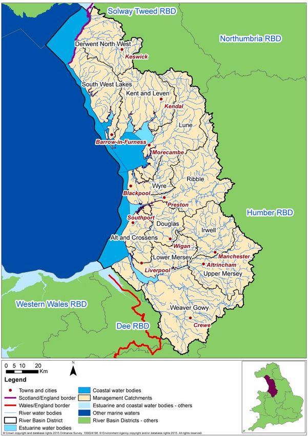
Executive summary
The Flood Risk Management Plan (FRMP) for the North West River Basin District (RBD)
provides an overview of the range of flood risks from different sources across the 12
catchments of the RBD and more specifically from local flood sources in the 2 Flood Risk
Areas (FRAs) of Liverpool and Sefton and Greater Manchester. The RBD catchments are
defined in the River Basin Management Plan (RBMP) and based on the natural configuration
of bodies of water (rivers, estuaries, lakes etc.). The 2 FRAs were identified as having higher
local flood risk by the Preliminary Flood Risk Assessments.

The FRMP provides a range of objectives and programmes of measures identified to
address risks from all flood sources. These are drawn from the many risk management
authority plans already in place but also include a range of further strategic developments for
the FRMP ‘cycle’ period of 2015 to 2021. The range of measures in the North West RBD
FRMP are reported under the following types of flood management action:

Types of flood management measures                                      % of RBD measures

Prevention – e.g. land use policy, relocating people at risk etc.                       7%
Protection – e.g. various forms of asset or property-based protection                  60%
Preparedness – e.g. awareness raising, forecasting and warnings                        32%
Recovery and review – e.g. the ‘after care’ from flood events
FRMP RMA plans                       Screened out          Measures from             New cycle 1
                                        measures            existing plans            measures1
NW RBD catchments                                179                     179                     71

FRA Liverpool and Sefton                            2                     24                      0

FRA Greater Manchester                             18                     18                     44

                         Total             199 (37%)              221 (41%)              115 (22%)

The HRA has been carried out for the set of measures for each RBD catchment that address
main river, sea and reservoir flooding alongside any measures volunteered by RMAs that
address local flooding and thus form a ‘RBD plan’ within the FRMP. Measures within FRAs
that address high risk of local flooding in these areas have been considered in the HRA as
separate ‘FRA plans’ within the FRMP. Both ‘RBD plan’ and ‘FRA plans’ are further
considered in-combination by the HRA. The findings are a summary of the risks to European
sites and an indication of the need for future HRAs at a project level when developing local
actions, as well as considering how to avoid and mitigate any residual risks to European
sites.
For the North West RBD FRMP, the main conclusions from the stages of assessment across
all 3 RMA plans of the FRMP are as follows:

A determination was made to screen out measures that would not have physical effects on
any European sites.

The effects of the measures from existing plans include effects of measures to address
coastal flooding from SMPs, measures to address main river flooding from CFMPs and
measures to address local flooding from local strategies. Existing controls and mitigation
from these plans include: for SMPs, development of coastal strategies, accompanied by
more detailed HRAs for relevant SMP Policy Areas, and for CFMPs and Local Strategies
more detailed appraisal and assessment on plans or projects arising out of the plans to
demonstrate meeting the requirements of the Conservation of Habitats and Species
Regulations 2010, as amended (Habitats Regulations).

The effects of the measures that are for new flood risk management priorities for the next
FRMP cycle period of 2015 to 2021 have been considered within this strategic-plan level
HRA as far as they can be assessed at this high level. This HRA considered the range of
mitigation options that may be applicable. It is concluded that the measures are expected to
be able to be avoided or mitigated as part of their development as local actions, and all
measures have been identified as capable of being fully mitigated. It can therefore be
concluded that at the plan level there is sufficient scope for ensuring no likely significant
effects during its implementation. The detail of the controls and mitigation required will be
assessed as part of requirements to meet consents under planning and other consenting
mechanisms as part of a project level HRA, some of which may need to proceed to
appropriate assessment in order to gather the necessary level of detail.

The HRA considers the potential for in-combination effects with other plans and projects.
Given the level of information currently available, the assessment has identified the plans

1
 Measures across several catchments are counted up for each catchment for HRA purposes which may be a
different figure than reported in the FRMP.

                                                   3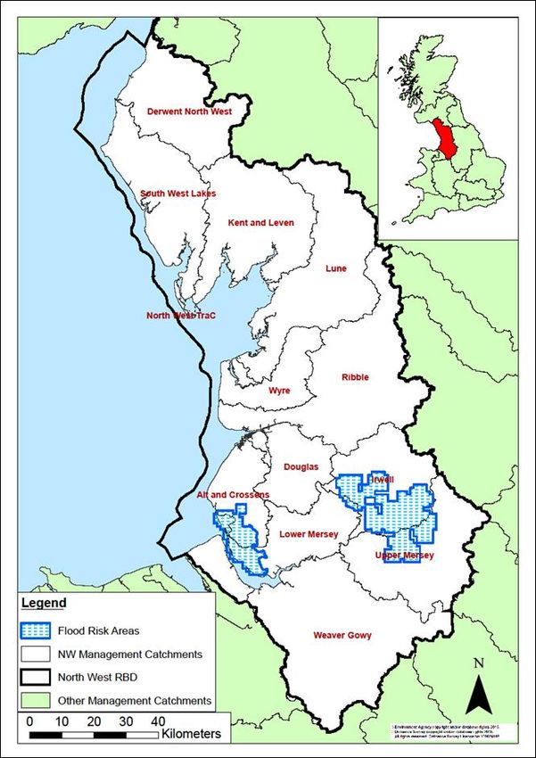
where the greatest risk of in-combination effects occur, but a detailed assessment can only
be undertaken at the project level when details of location and design of measures are
known. Key external plans to consider for in-combination effects are:
Local Plans – plans of local planning authorities to determine consent for proposed
developments including FCRM ‘Protection’ types of development and which require
HRA for developments affecting European sites
Water Resource Management Plans – plans to manage the supply of water to
communities by Water Companies.
River Basin Management Plans – plans that seek to ensure the objectives of water
dependent European sites are maintained.
Marine Plans – plans to manage the sustainable use of marine resources for inshore
areas.
This HRA does not remove the need for HRA at a subsequent level, i.e. lower tier strategies,
plans or projects that implement measures. This plan-level HRA does not give any weight to
subsequent lower-tier plans or projects and their HRA outcomes.
As local actions are developed at a project level and the details of their scope and scale are
known, this may identify additional effects on European sites that have not been assessed
here, or were not appropriate to consider at this spatial scale of plan.
4
CONTENTS

1     Introduction .................................................................................................................... 7
    1.1     Introducing this report ............................................................................................. 7
    1.2     Background to the FRMPs ...................................................................................... 8
    1.3     The North West RBD FRMP ................................................................................... 8
    1.4     Background to Habitats Regulations Assessment ................................................. 10
2     European sites in the North West RBD ........................................................................ 12
    2.1     European sites that could be affected by the FRMP.............................................. 13
    2.2     European sites and their status for FRMPs ........................................................... 13
    2.3     European sites and their management.................................................................. 14
3     Approach to the HRA ................................................................................................... 15
    3.1     Description of the FRMP programmes of measures .............................................. 15
    3.2     Screening and Likely Significant Effects................................................................ 16
    3.3     Screening out catchments where no European sites are present .......................... 16
    3.4     Screening out measures that would not have physical effects .............................. 16
    3.5     Considering measures from existing plans ............................................................ 17
    3.6     Considering new measures for FRMP cycle 1 ....................................................... 18
    3.7     Considering the need for further stages of assessment ........................................ 18
4     North West River Basin District Catchments HRA ........................................................ 20
    4.1     Summary of Measures .......................................................................................... 20
    4.2     Screening and Likely Significant Effects................................................................ 22
    4.3     Consideration of results and conclusion ................................................................ 45
5     Liverpool and Sefton Flood Risk Area HRA.................................................................. 49
    5.1     Summary of Measures .......................................................................................... 49
    5.2     Screening and Likely Significant Effects................................................................ 50
    5.3     Consideration of results and conclusion ................................................................ 53
6     Greater Manchester Flood Risk Area HRA................................................................... 54
    6.1     Summary .............................................................................................................. 54
    6.2     Screening and Likely Significant Effects................................................................ 56
    6.3     Consideration of results and conclusion ................................................................ 61
7     In combination effects with other plans and projects .................................................... 62
    7.1     RBD and FRA FRMPs .......................................................................................... 62
    7.2     In-combination effects between RBD FRMPs ....................................................... 63
    7.3     In-combination effects with external plans ............................................................. 63
8     Conclusion and Future HRAs ....................................................................................... 65

                                                                   5
Annex A:
Table A1 – HRA screening table for the FRMP measure categories
Table A2 – Management Catchments and European sites in the NW RBD / FRMP
Table A3 – Mitigation and Control Measures

Annex B – North West RBD European sites

                                             6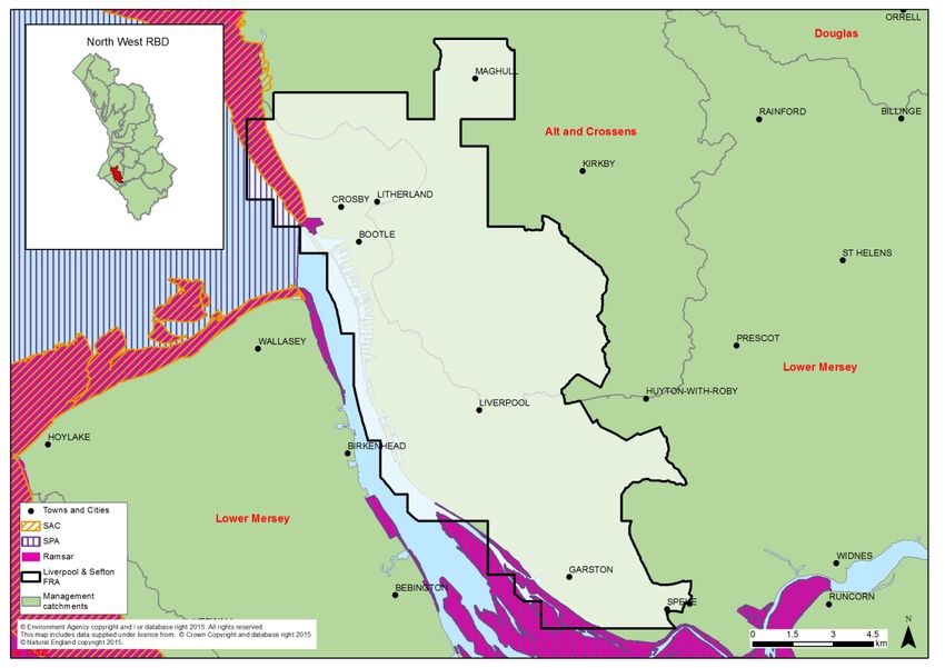
1 Introduction
1.1 Introducing this report
This report sets out the results of a strategic-plan level Habitat Regulations Assessment
(HRA) into the likely significant effects on designated ‘European sites’ of the Flood Risk
Management Plan (FRMP) for the North West River Basin District, published in December
2015. The HRA report has been prepared by the Environment Agency on behalf of the
collective Risk Management Authorities (RMAs) that have responsibilities for information
being published within the FRMP, and are thus the ‘competent authorities’ for the HRA of
their respective published information, as follows:
Information on flooding from main river, sea and reservoirs being published for the
catchments of the river basin district (RBD) are the responsibility of the Environment
Agency (for English catchments).
Information on flooding from local sources being published for any Flood Risk Area
(FRA) is the collective responsibility of Lead Local Flood Authorities within the FRA.
In preparing the HRA report the Environment Agency has consulted with Natural England
(for English catchments) and Natural Resources Wales (for Welsh catchments / European
sites in Wales). The Lead Local Flood Authorities in Flood Risk Areas are ‘competent
authorities’ for HRA of their FRMP information and have agreed that this report will meet
their HRA requirements.
FRMPs are new strategic plans for implementing the Flood Risk Regulations 2009 and the
existing National Flood and Coastal Erosion Risk Management (FCERM) Strategy for
England. They have been developed for River Basin Districts (RBDs) and Flood Risk Areas
(FRAs) and draw together information from a range of existing strategies and plans that are
in place and continue to be maintained by Risk Management Authorities. The HRA has been
carried out at the level of detail published in the FRMP and takes into account HRAs that
have already been undertaken for measures in existing plans, and at the level of detail
provided by these existing plans. Whilst a HRA at this strategic level cannot obtain the level
of detail necessary for in-depth assessment, the HRA summarises the likely risks and
potential need for controls and mitigation and the range of generic mitigation options
available, which will then proceed through further consideration once measures are
developed as specific local actions. In this way, this high-level HRA will be helpful for future
HRAs that consider the effects on European sites at a project level.
The report describes each of the main stages and results of the FRMP HRA as follows:
Describing the network of European sites within the RBD (chapter 2)
The approach to the HRA (chapter 3)
Screening and assessing likely significant effects (chapters 4,5,6)
Appropriate assessment, alternative solutions and imperative reasons of overriding
public interest (IROPI) (chapters 4,5,6)
Conclusion and future HRAs (chapter 8).
71.2 Background to the FRMPs
Flood risk management plans (FRMPs) highlight the hazards and risks from rivers, the sea,
surface water, groundwater and reservoirs and set out how risk management authorities,
such as the Environment Agency and local authorities, will manage flood risk. They are
required by the European Union Floods Directive and the Flood Risk Regulations 2009. The
FRMPs must be reviewed and reissued every six years to describe progress.
The Environment Agency is required to prepare FRMPs for all of England covering flooding
from main rivers, the sea and reservoirs. Lead Local Flood Authorities (county councils and
unitary authorities) must prepare flood risk management plans for flood risk areas (there are
ten flood risk areas in England) where the risk of flooding from local sources is significant as
identified in Preliminary Flood Risk Assessments.
The 2015-2021 period will be the first cycle of the FRMPs, however RMAs already plan for
flooding and a large proportion of the FRMP measures are taken from existing plans that
have already been consulted on and published. This includes plans such as Catchment
Flood Management Plans (CFMPs) and Shoreline Management Plans (SMPs) as well as
Local Flood Risk Management Strategies that have been developed by local authorities.
Some further strategic developments have been included for the 2015-2021 first cycle of the
FRMP that build on existing plans and seek to address the key objectives of the Flood Risk
Regulations 2009, such as: strengthening joint working of RMAs, developing more integrated
management of the water environment, and updated priorities from any new understanding
of flood risks including the implications of climate change.
1.3 The North West RBD FRMP
The North West river basin district (RBD) is predominantly rural with the majority of the 7
million people living in large cities in the south of the RBD such as Manchester and
Liverpool. It contains large areas designated for their iconic landscapes such as the Lake
District and many areas protected for nature conservation such as the Mersey Estuary.
Water is central to the economy, life and heritage of the North West, for example mills, weirs
and other water related structures dating from the Industrial Revolution, and tourism
attractions such as the Lake District and Blackpool’s beaches. The North West RBD is made
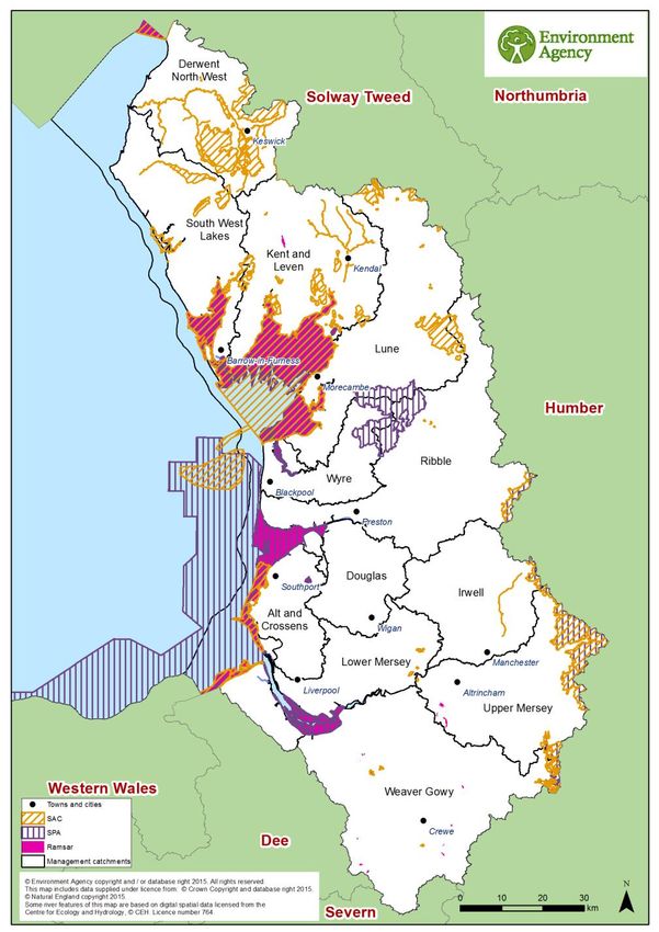
up of 12 management catchments (see map in Figure 1 below).
The FRMP describes the scale of flood risk in the NW RBD which includes:
27,900 people at high risk (up to a 1 in 30 chance in any given year) of flooding from
surface water and 30,900 from rivers and the sea. For moderate risk (between a 1 in
30 and 1 in 100 chance in any given year), twice as many people (105,000) are
potentially affected by surface water as by rivers and the sea (46,500).
Many thousands of properties behind sea and tidal defences which protect them from
a flood with a 1 in 200 chance in any given year. This includes some key towns such
as Blackpool, Wirral, Morecambe, Barrow, Whitehaven and Workington and some
towns along estuaries.
The NW RBD has one of the highest numbers of rapid response catchments in
England. These are areas where flooding may occur quickly after rainfall.
8 The RBD also has a large network of ageing sewers and drains, many dating from
the Victorian era. This and the surge in development since the Industrial Revolution
now pose particular problems, as significant proportions of flood risk management
and drainage infrastructure show evidence of deterioration.
Other key infrastructure includes significant numbers of reservoirs in the NW RBD
that are priorities for maintenance given the high consequences of any failure and
3,000 culverts on main rivers which require significant levels of inspection and repair
as well as clearance during flood events.
In general, groundwater is not a significant source of flooding in the NW RBD.
Figure 1 North West RBD catchments and Flood Risk Areas
The North West RBD FRMP sets out the objectives and measures that have been drawn by
risk management authorities from existing plans or newly developed for the FRMP cycle
9period of 2015-2021. Existing measures in the North West RBD FRMP are derived from the
following source plans:
The North West England and North Wales Shoreline Management Plan (SMP)
Catchment Flood Management Plans (CFMPs)
Local Flood Risk Management Strategies (FRMS) developed by LLFAs.
The FRMP is divided into the separate plans that are the responsibility of different risk
management authorities, as follows:
Measures within the 12 RBD catchments of the North West RBD that the
Environment Agency is responsible for,
Measures within the Liverpool and Sefton Flood Risk Area (FRA) for local sources of
flooding that fall within the Alt and Crossens and Lower Mersey catchments.
Liverpool City Council and Sefton Council are responsible for these measures.
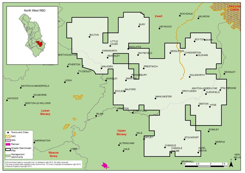
Measures within the Greater Manchester FRA for local sources of flooding that the
Lead Local Flood Authorities are responsible for. This FRA covers part of the Irwell,
Upper Mersey and Lower Mersey catchments.
1.4 Background to Habitats Regulations Assessment
In England and Wales, the Conservation of Habitats and Species Regulations 2010, as
amended, commonly termed the Habitats Regulations, implements the European Union
Habitats Directive (Directive (92/43/EEC) on the Conservation of natural habitats and of wild
flora and fauna, and certain elements of the Wild Birds Directive (2009/147/EC). This
legislation provides the legal framework for the protection of habitats and species of
European importance in England.
Sites protected under the Habitats Regulations comprise Special Protection Areas (SPA),
Special Areas of Conservation (SAC), candidate SACs (cSAC), Sites of Community
Importance (SCI) and, as a matter of government policy, to potential Special Protection
Areas (pSPA) and Ramsar sites (sites designated under the 1971 Ramsar Convention for
their internationally important wetlands). These sites are referred to collectively as in this
report as ‘European sites’.
Regulation 9(3) of the Habitats Regulations requires that a ‘competent authority’ must
consider the requirements of Habitats Directive in exercising any of its functions. Article 6(3)
of the Habitats Directive defines the requirements for assessment of plans and projects
potentially affecting European sites. This requires that a competent authority, before
deciding to undertake, or give any consent or authorisation for a plan or project which is
likely to have a significant effect on a European site, and is not directly connected with or
necessary to the management of that site, must carry out an appropriate assessment. The
term commonly referred to for the assessment process is ‘Habitats Regulations
Assessment’.
The NW FRMP is considered to fit within the definitions of a ‘plan’ as defined by the Habitats
Directive, and requires a Habitats Regulations Assessment (HRA). The FRMP is a high-
level planning document for the NW River Basin District (RBD) (see map in Figure 1),
therefore potential impacts of the plan on European sites across the RBD are difficult to
10determine. Given the geographic scale and nature of the plan, the HRA has been tailored to
be appropriate for the spatial area of coverage and the strategic nature of the plan.
The Habitats Regulations Assessment has followed a framework of four distinct stages, only
moving to the next stage if required by the results of that stage of the assessment. The four
stages are:
Stage 1: Screening and Likely Significant Effects is the process which initially identifies
the likely impacts upon a European site of a plan or project, either alone or in combination
with other plans or projects, and considers whether these impacts may be significant. This
stage also includes the development of mitigation to avoid or reduce any possible effects.
Stage 2: Appropriate Assessment is the detailed consideration of the impact on the
integrity of the European site of the plan or project, either alone or in combination with other
plans or projects, with respect to the site’s conservation objectives and its structure and
function. This is to determine whether there is objective evidence that adverse effects on the
integrity of the site can be excluded. This stage also includes the development of mitigation
to avoid or reduce any possible effects.
Stage 3: Assessment of alternative solutions is the process which examines alternative
ways of achieving the objectives of the plan or project that would avoid adverse impacts on
the integrity of the European site, should avoidance or mitigation be unable to avoid adverse
effects.
Stage 4: Assessment where no alternative solutions exist and where adverse effects
remain is made with regard to whether or not the plan or project is necessary for imperative
reasons of overriding public interest (IROPI) and, if so, of any required compensatory
measures.
112 European sites in the North West RBD
Within the North West RBD there are 28 SACs, 13 SPAs, and 13 Ramsar sites. Some of the
sites have more than one designation such as Morecambe Bay, parts of which are
designated as SPA, SAC and Ramsar.
Figure 2 - Map of the European sites in the North West River Basin District
Although most of the European sites contain a variety of habitat types, broadly speaking they
could be described as coastal and marine sites, freshwater sites (comprising rivers, lakes,
canals and other wetlands) and terrestrial sites such as woodlands, grasslands and
moorlands.
12Of the 13 Ramsar sites, 7 are coastal sites and the remainder are freshwater sites. Most
SPAs in the RBD are wetland habitats, and of these most are coastal apart from the
freshwater sites of Martin Mere and Leighton Moss. The remaining 3 SPAs are upland sites
(Peak District, South Pennine Moors and the Bowland Fells), designated for breeding birds.
The 28 SACs in the North West RBD range in size and nature from the relatively small Clints
Quarry (12 hectares (ha)), which is designated for its population of Great Crested Newts, to
Morecambe Bay (61,506 ha), which is designated for a number of qualifying habitats.
Annex B contains a summary of the European sites present within North West RBD. Table
A2 in Annex A presents a summary of the European sites present within the management
catchments of the North West RBD. In a number of cases European sites cross over the
boundary of two or more management catchments, therefore a number of European site
names / designations may appear against more than one management catchment.
2.1 European sites that could be affected by the FRMP
The North West FRMP is a long term plan for the water environment, which could potentially
affect both water dependent and non water-dependent European sites and their qualifying
features.
It is not possible from the outset to rule out, at the RBD scale, any (water-dependent or non
water-dependent) European sites from being affected by the North West FRMP. The HRA
(in particular Sections 4.2, and 5.2 / 6.2 for the two FRAs) reviews the European sites by
management catchment, and determines whether any of the measures within the
catchments are likely to lead to significant effects on European sites.
2.2 European sites and their status for FRMPs
The North West RBMP provides summary information on the current status and baseline for
water-dependent European sites as part of its monitoring data.
European sites in England, with the occasional exception, are also designated as SSSIs.
Natural England monitors the conditions of SSSIs and their component units using six
reportable condition categories: favourable; unfavourable recovering; unfavourable no
change; unfavourable declining; part destroyed and destroyed.
The current status of water-dependent European site protected areas for the North West
RBD is summarised in table 1 below. This gives the current area of water-dependent SSSI
units of European protected areas in different condition categories as currently recorded on
Natural England’s designated site data system. SSSI units underpin European protected
areas and Natural England only collects data at a SSSI unit level. When SSSI units are in
favourable condition, they are deemed to be meeting their conservation objectives.
The table shows that for the North West RBD, 30% of water-dependent SSSI units of
European protected area sites are currently not compliant with the condition requirements.
13Table 1 Status of water-dependent European sites based on assessment of SSSIs
units for the North West RBD (Extract from Natural England databases August 2015)
Condition North West RBD (ha)
Favourable 74,505
Destroyed / Part destroyed -
Unfavourable declining 1,253
Unfavourable no change 3,104
Unfavourable recovering 27,450
Total Area Unfavourable 31,807
% Unfavourable 30
The generic pressures on such sites in the NW region include freshwater point source and
diffuse pollution, siltation, forestry and woodland management, agricultural practices and
diffuse pollution, under or over grazing, drainage and inappropriate water levels, invasive
non-native species, and public access and disturbance. There are also long term national
threats to habitats and especially species, including climate change, alterations in
hydrological and coastal processes and invasive non-native species.
2.3 European sites and their management
As part of a new strategic approach to managing all England’s European sites, new
measures needed to achieve favourable conservation status for all European sites in
England have been developed by Natural England. These are collectively referred to as Site
Improvement Plans (SIPs), and are being developed by the Improvement Programme for
England’s Natura 2000 sites (IPENS). SIPs were published for all European sites in
England in 20152.
The North West FRMP recognises SIPs include actions where flood risk management is
specifically a mechanism for their delivery. The following are the relevant SIPs for the North
West RBD:
Site Improvement Plan: Leighton Moss (SIP119)
Site Improvement Plan: Martin Mere (SIP133)
Site Improvement Plan: River Derwent and Bassenthwaite Lake (SIP190)
Site Improvement Plan: River Kent (SIP194).
2
Site Improvement Plans for the North West River Basin District can be found on:
http://publications.naturalengland.org.uk/category/6287197783195648
143 Approach to the HRA
The steps undertaken to complete the HRA are as follows:
describe the plan and the measures proposed
screen and assess the likely significance of any effects on European sites
consider need for further stages of assessment (i.e. appropriate assessment,
alternative solutions and IROPI)
determine a plan level conclusion
3.1 Description of the FRMP programmes of measures
The North West River Basin District Flood Risk Management Plan (FRMP) is a joint
publication of several plans required under the Flood Risk Regulations that are the separate
responsibilities of specific Risk Management Authorities (RMAs), as follows:
North West River Basin District catchments (Environment Agency)
Liverpool and Sefton Flood Risk Area (LLFAs within the FRA)
Greater Manchester Flood Risk Area (LLFAs within the FRA).
3.1.1 River Basin District Catchments
FRMPs for the River Basin District (RBD) are being published by the Environment Agency
(for English catchments) and Natural Resources Wales (NRW) (for Welsh catchments), and
are focused on measures principally to address flood sources from main river, the sea and
reservoirs. The measures have been divided into catchments based on the River Basin
Management Plans (where they are called ‘management catchments’).
Production of the FRMPs for the RBDs is the legal duty of the Environment Agency and
NRW. Where any voluntary information on local sources of flooding within RBD catchments
has been provided by LLFAs, these are published by joint agreement in the RBD FRMP.
The Environment Agency and NRW are also the competent authority under the Habitats
Regulations for the RBD FRMPs.
3.1.2 Flood Risk Areas
FRMPs for Flood Risk Areas (FRAs) are being published by the Lead Local Flood
Authorities (LLFAs) where the FRAs lie within their administrative boundaries. Production of
the FRMPs for the FRAs are the legal duty of the respective LLFAs. The LLFAs responsible
for the FRA FRMPs are also the competent authority under the Habitats Regulations.
Where a RBD includes one or more FRA, as is the case for the North West RBD, the
measures that have been developed specifically for these FRA FRMPs are presented and
assessed separately.
3.1.3 Applying HRA
In applying the HRA process, each RMA plan has been assessed separately. A final
summary of conclusions and recommendations for future HRAs is provided that also draws
on a high-level summary of the potential for in-combination effects of the FRMP with other
key plans.
153.2 Screening and Likely Significant Effects
This first stage of the HRA process requires consideration of screening and likely significant
effects of measures on European sites. The tasks undertaken to complete this are as
follows, and set out in more detail below:
screening out catchments where no European sites are present
screening out measures that would not have physical effects
considering measures from existing plans, with mitigation / controls already agreed in
HRAs for any likely significant effects, or in some cases potential adverse effect on
site integrity
considering new measures and their likely significant effects, with mitigation / controls
where considered necessary
conclusion from screening and likely significant effects.
The results of these tasks for each RMA’s plan of the FRMP are provided in the following
chapters:
Chapter 4: NW River Basin District catchments
Chapter 5: Liverpool and Sefton Flood Risk Area
Chapter 6: Greater Manchester Flood Risk Area.
3.3 Screening out catchments where no European sites are present
Where there are no European sites present in a catchment, it was determined that no further
consideration of measures in the catchment is required. Given the level of detail in the plan
where the FRMP measures are mainly strategic in nature and are not specific on their
precise location, there is insufficient details to consider downstream or down drift effects
beyond the catchment. However, such screening for cross-catchment effects will be a
requirement in assessing local plans and projects.
3.4 Screening out measures that would not have physical effects
Every measure included within the FRMP is categorised according to one of the following 4
categories, accompanied by an M-code:
Prevention (M2) - reducing the impacts of flooding through land use and
development policy, relocation of assets at risk, or measures to divert the hazard to
avoid harm.
Protection (M3) - protecting people from the risk of flooding; for example, by the
maintenance, refurbishment of existing defences or building new defences.
Preparedness (M4) - by taking actions that prepare people for flooding; for example,
by improving awareness of flood risk, or by providing warning and forecasting for
floods.
16 Recovery and review (M5) - supporting recovery after flooding has happened and
reviewing how things can be improved; for example, by improving the availability of
recovery services such as providing temporary accommodation.
Other (M6) – measures not fitting in to any of the above categories.
Further definitions of each of the measures are set out in the FRMP according to a second
tier of M-codes. For example, Prevention (M2) includes the second tier measure, M22, which
is defined as “Prevention, removal or relocation measure to remove receptors from flood
prone areas or to relocate receptors to areas of lower risk”. These measure definitions have
been used as the basis for the initial screening out of the measures that require no further
consideration within the HRA.
The measure codes and their definitions are included as Table A1 (in Annex A to this
document). Measures under ‘Preparedness’ (M4) and ‘Recovery and review’ (M5) will not
result in development, demolition or changes of management ‘on the ground’ that could
result in effects on European sites. These were therefore screened out from any further
consideration. Similarly, under the ‘Prevention’ category (M2), only the removal or relocation
of receptors from flood prone areas could potentially affect European sites. The measures
that have been screened in to the assessment are set out below and have been highlighted
in Table A1:
M22 – Prevention – removal or relocation (category)
M3 – Protection – all sub-categories
M6 – Other – not yet defined.
3.5 Considering measures from existing plans
Risk Management Authorities have a range of plans in place for developing and
implementing measures related to flooding from main river (in Catchment Flood
Management Plans), to flooding from the sea (in Shoreline Management Plans) and related
to local sources of flooding (e.g. in Local Flood Risk Management Strategies). These plans
have been subject to HRA where relevant, and have reported on the effects on European
sites consistent with the level of detail of the plans.
For this HRA, these existing HRAs have been used to summarise the effects of measures
from existing plans that are now set out under specific RBD catchments or FRAs. For many
RBD catchments and FRAs there are multiple existing plans covering the geographic area
but also some existing plans that are split across RBD catchments or FRAs. Nonetheless we
have separated out the ‘screened in’ measures from individual existing plans and referenced
the specific HRA results that apply to them.
The results from existing HRAs have considered the extent that they remain valid since they
were published. This has been done by checking the status of the relevant European sites
that were considered within the source plan’s HRA for any changes to site designations
since the date of the HRA publication. The criteria were agreed with Natural England and
comprised: whether there were any new / additional site designations, any changes in site
boundaries, changes in designated site features, or any significant changes in site
conditions.
17The HRA results from Shoreline Management Plans are relatively recent with most
published between 2010 and 2011. The HRA results from Catchment Flood Management
Plans are a little older with most published between 2008 and 2010. The HRA results from
Local Flood Risk Management Strategies are the most recent with the first ones being
published around 2012 and most being published much more recently.
One of the main reasons for a likely change from when the effects of plan measures were
reported in HRAs is where there have been boundary changes to European sites or to the
scope of condition of the interest features of the sites i.e. specific habitats, species etc.
Where we have been advised that such changes have occurred and are significant then this
has triggered further consideration of the validity of the existing HRA results that we have
relied upon.
3.6 Considering new measures for FRMP cycle 1
In reviewing the range of measures across existing plans covering all sources of flooding,
Risk Management Authorities (RMAs) have taken the opportunity to put forward further
strategic developments for the next 6 year cycle of the FRMP. These ‘new measures’ focus
on: strengthening the joint working of RMAs across all flood sources; developing more
integrated management of the water environment as set out in the River Basin Management
Plans and other related plans; and updating flood risk information to help manage risks with
communities.
For this HRA we have reviewed the set of new measures that have been ‘screened in’ for
each catchment. As they are mostly ‘strategic’ measures without specific information on
location or the form of action that would be developed on the ground, we have considered a
range of factors that would give rise to any likely risks from this set of measures in a specific
catchment, which includes:
their general proximity in the catchment to European sites
whether they aim to address sources of flooding that are local, or main river or
related to the coast
the mix of types of new measures within the catchment denoted by their M-codes
(i.e. whether they are mainly maintenance, or channel works, or new solutions).
General proximity was considered by narrowing down the set of measures within a
catchment to those that were closer in general and more likely to be connected to European
sites by the hydrology of the catchment rather than applying specific buffer distances to
individual measures.
3.7 Considering the need for further stages of assessment
HRA steps were carried out for each RBD catchment of the RBD plan that is the
responsibility of the Environment Agency. Further HRA steps were carried out for each FRA
(by catchment) that is the responsibility of respective Lead Local Flood Authorities. The
determination for each catchment or FRA that there are no likely significant effects to
European sites, is based on the following assumptions:
that this HRA does not remove the need for HRA at a subsequent level, i.e. lower tier
strategies, plans or projects that implement measures, nor does it give any weight to
18their outcomes. Consideration of potential impacts and options available to mitigate
for those impacts should assist, but not influence or constrain any lower-tier
assessments.
that as local actions are developed at a project level and the details of their scope
and scale are known, that this may identify additional effects on European sites that
have not been assessed here, or were not appropriate to consider at this spatial
scale of plan.
194 North West River Basin District Catchments HRA
This chapter sets out the results of carrying out the HRA on the measures for the North West
RBD catchments that are for flooding from main river, sea and reservoirs and for local
flooding sources outside of Flood Risk Areas. This is the FRMP information for which the
Environment Agency is the FRMP ‘statutory authority’ and HRA ‘competent authority’. The
Flood Risk Area FRMP information for which other RMAs have responsibility has been
considered separately in later chapters of the HRA (see sections 5 and 6).
This section covers the following stages of the assessment:
Summary of measures being assessed
Screening and assessment of likely significant effects
Consideration of results and conclusion.
4.1 Summary of Measures
The initial screening and assessment of likely significant effects reviewed the measures for
each of the 12 management catchments within the NW FRMP.
Figure 3 - Map of the North West river basin district and management catchments
A summary of the measures and their screening is given below for each catchment.
20Table 2 Summary of measures by catchment
Number of measures
Number of measures
Management Number of measures related to types of Number of new measures and
Number of European
from existing plans1
measures for cycle1
Catchment existing plans1 known level of detail1
screened in (out)
Number of new
sites
Catchments with no screened in measures
All catchments have some screened in measures.
Catchments with all measures from existing plans
Alt and 32 32 30 from River Alt and Crossens CFMP 0 No new measures 5
Crossens (10) 2 from NW England and N.Wales SMP
Douglas 36 36 30 from River Douglas CFMP 0 2
(7) 6 from NW England & N Wales SMP
Wyre 6 6 6 from River Wyre CFMP 0 4
(17)
Sub-total 74 74 66 from CFMPs 0
(34) 8 from SMPs
% all 17% 17% (n/a)
measures
Catchments with new measures for cycle 1 of the FRMP
NW RBD 20 0 0 from existing plans 20 20 strategic/proximity unknown 54
Wide (31)
Derwent 17 11 8 from River Derwent CFMP 6 1 not in proximity 9
North West (10) 3 from NW England and N.Wales SMP 4 strategic/proximity unknown
1 specific/in proximity
Irwell 17 6 6 from River Irwell CFMP 11 8 not in proximity 3
(4) 3 strategic/proximity unknown
Kent and 11 6 3 from River Kent and Leven CFMP 5 3 specific/in proximity 12
Leven (28) 3 from NW England and N.Wales SMP 2 strategic/proximity unknown
Lune 25 22 20 from River Lune CFMP 3 1 not in proximity 10
(14) 2 from NW England and N.Wales SMP 2 specific/in proximity
Lower 17 3 2 from Mersey Estuary CFMP 14 10 not in proximity, 12
Mersey (13) 1 from NW England and N.Wales SMP 3 specific/in proximity
1 strategic/proximity unknown
South West 10 7 3 from South West Lakes CFMP 3 3 strategic/proximity unknown 8
Lakes (21) 4 from NW England and N.Wales SMP
Weaver 11 10 9 from Weaver and Gowy CFMP 1 1 not in proximity 10
Gowy (9) 1 from LFRMS
Upper 15 13 13 from Upper Mersey CFMP 2 1 not in proximity 6
Mersey (6) 1 strategic/proximity unknown
Ribble 32 26 25 from River Ribble CFMP 6 6 not in proximity 7
(9) 1 from NW England and N.Wales SMP
Sub-total 175 104 89 from CFMPs 71 28 not in proximity
(145) 14 from SMPs 34 strategic/proximity unknown
1 from LFRMS 9 specific/in proximity
% all 41% 24% 17%
measures
Overall 249 179
155 from CFMPs 71 See above
Total (179) 22 from SMPs
1 from LFRMS
% all 58% 42% 36% from CFMPs 17% 7% not in proximity
measures 5% from SMPs 8% strategic/proximity unknown3
Measures across several catchments are counted up for each catchment for HRA purposes which may be a higher
figure than reported in the FRMP.
Of the total of 428 measures 58% have been screened in for HRA consideration (42%
screened out). All management catchments within the NW RBD have some screened in
measures and are considered further.
There are 51 measures that are RBD-wide and are considered in section 4.2.4.1.
There are a number of measures from neighbouring river basin districts that were included in
NW RBD catchments including measures from:
The Humber RBD and within the West Midlands FRA which are considered within the
Humber RBD HRA
The Solway Tweed RBD which are considered within the NW RBD HRA catchment
sections below.
4.1.1 Risks from existing plan measures
42% of all FRMP measures (excluding Flood Risk Areas) are screened in and from existing
plans, 36% are from CFMPs and 5% from SMPs. Most risks are from SMP measures where
adverse effects identified in the SMP HRA for specific policy areas are being addressed.
Most risks to European sites that are being addressed by existing plans relate to the (5%)
measures in SMPs, and more specifically where the SMP is managing likely adverse effects,
such as in the catchments of Alt and Crossens, Lower Mersey and South West Lakes.
4.1.2 Risks from new measures
17% of all FRMP measures (excluding Flood Risk Areas) are screened in for HRA and new
measures, 8% are strategic without locations, 7% are not in proximity to any European sites
and 2% are more specific improvements that are in proximity to sites. The most likely risks
will be related to the development of local actions for the specific improvements in the next
FRMP cycle and can be found in the Lower Mersey, Kent and Leven, Lune and Derwent
North West catchments. The future strategic measures may also present a risk depending
on where they are implemented.
4.2 Screening and Likely Significant Effects
The management catchments that make up the NW RBD FRMP are set out in table 3 below.
The colour coding in the table summarises the nature and source of the bundle of measures,
which forms the basis for how each management catchment has been assessed. The
following sub-sections consider each of the management catchments in turn.
22Table 3 Management Catchments of the NW RBD /FRMP
Management Catchment Category Management Catchments
Management catchments with no None
European sites present.
Management catchments with no None
‘screened in’ measures.
Management catchments with all - Alt & Crossens - Wyre
measures from existing plans. - Douglas
Management catchments with new - Derwent North West - South West Lakes
measures. - Irwell - Weaver Gowy
- Kent and Leven - Upper Mersey
- Lune - Ribble
- Lower Mersey
4.2.1 Management catchments with no European sites present
All management catchments within the North West RBD have European sites present,
therefore no management catchments have been ruled out of further consideration on this
basis.
4.2.2 Management Catchments with no ‘screened in’ measures
All management catchments within the North West RBD have screened in measures,
therefore no management catchments have been ruled out of further consideration on this
basis.
4.2.3 Management Catchments with all measures from existing plans
The following management catchments in the North West FRMP do not contain any FRMP
new measures; they contain only measures from existing plans.
Each of these plans has already been subject to consultation and assessment, including
HRA. The HRA conclusions for those source plans have been referred to in each case.
4.2.3.1 Alt & Crossens Management Catchment
European New measures Existing plan measures
sites
Screened in Screened out Screened in Screened out
5
0 0 32 10
The Alt & Crossens management catchment contains 5 European sites. There are no new
measures within this catchment; all of the 42 measures are from existing plans.
Alt & Crossens CFMP
Most of the measures are from the Alt & Crossens CFMP. The majority of the screened in
CFMP measures are protection measures (M3) and are considered further below; the two
23screened out CFMP measures relate to emergency flood event response / contingency
planning.
The Alt & Crossens CFMP boundary is the same as the Alt & Crossens management
catchment within the NW FRMP. The 30 CFMP protection measures incorporated within the
Alt & Crossens management catchment, implement the policies of the CFMP, which were
assessed by the Alt & Crossens CFMP HRA. The Ribble & Alt Estuaries SPA and Ramsar
site, Martin Mere SPA and Ramsar site, and the Sefton Coast SAC lie within the catchment
boundary. The CFMP HRA assessed potential effects on these sites and concluded
that the policies and actions within the Alt & Crossens CFMP were not likely to have a
significant effect on any European sites.
North West England and North Wales Shoreline Management Plan
The remainder of the measures in the management catchment are from the North West
England and North Wales Shoreline Management Plan 2 (SMP)3.
Of the 10 measures from the SMP, 8 relate to preparedness for flood events (M44) and have
been screened out. The 2 SMP protection measures (M35) are considered further below.
The SMP measures are located within the Seaforth to River Alt Policy Area – Policy Unit
11a8.4 (River Alt Mouth (east and west banks) to the Alt Pumping Station) and the Formby
Dunes Policy Area – Policy Unit 11a9.1 (Mouth of River Alt (west bank) to Weld Road,
Southport (Formby Dune System)), within sub-cell 11a of the NW and North Wales SMP.
The measures are located in proximity to the Sefton Coast SAC, Ribble & Alt Estuaries SPA
and Ramsar sites.
The HRA of the SMP concluded a potential adverse effect of the Hold the Line (HTL)
policy for Policy Unit 11a8.4 in the long term epoch (incorporating maintaining
existing defences and maintaining the River Alt channel position), in relation to the
Ribble & Alt Estuaries SPA and Ramsar Site and the Sefton Coast SAC.
For Policy Unit 11a9.1, the HRA concluded that there will not be adverse effects on the
integrity of the sites from the proposed (managed realignment) policy options.
Proposed mitigation within the SMP, in relation to PU11a8.4, comprises updating the
Crosby Marine Lake to Formby Point Coastal Defence Strategy (which includes this and
other adjacent and related Policy Units) to demonstrate that the implementation of the HTL
policy and potential managed realignment policy elsewhere will not have an adverse effect
on the integrity of the Ribble & Alt Estuaries SPA / Ramsar site and the Sefton Coast SAC.
The Crosby Marine Lake to Formby Point Strategy for Coastal Defence, accompanied by a
HRA, was approved in 2010. The HRA concluded that the strategy was not likely to result in
significant effect on the European sites, provided that the HRAs for the individual
components of the strategy conclude that there will be no adverse impacts on the features of
the European sites in the strategy area.
Proposed mitigation within the SMP, in relation to PU11a9.1, comprises further proposed
studies as part of the SMP2 Action Plan to develop and implement dune management
3
Also known as the Great Ormes Head to Scotland Shoreline Management Plan (SMP).
24adaptation strategy, and plans for developing a regional dune habitat restoration programme
as a strand of the Regional Habitat Creation Programme. A dunes restoration scheme has
subsequently been developed to implement this mitigation – the Hightown Dunes
Restoration Scheme.
The SMP HRA determined that, despite mitigation proposals, it cannot be concluded that
there will not be adverse effects on the Ribble & Alt Estuaries SPA and Ramsar Site, due to
uncertainties surrounding implementation of HTL Policy (in relation to PU11a8.4) in the long
term, to be treated as a potential adverse effect with a requirement that habitat to
offset adverse impacts may need to be provided as part of the Regional Habitat
Creation Programme. Due to this, a statement of case for Imperative Reasons of
Overriding Public Interest (IROPI) was required before the SMP2 could be formally
adopted.
4.2.3.2 Douglas Management Catchment
European New measures Existing plan measures
sites
Screened in Screened out Screened in Screened out
2
0 0 36 7
The Douglas management catchment contains 2 European sites.
There are no new measures within this catchment; all of the 43 measures are from existing
plans.
Douglas CFMP
Most of the measures for this catchment are from the Douglas CFMP. The screened in
CFMP measures are all protection measures (M3) and are considered further below; the five
screened out CFMP measures relate to flood forecasting and warning (M41).
The Douglas CFMP boundary is the same as the Douglas management catchment within
the NW RBD FRMP. The 35 CFMP protection measures incorporated within the Douglas
management catchment, implement the policies of the CFMP, which were assessed by the
Douglas CFMP HRA4. The Ribble & Alt Estuaries SPA and Ramsar site lie within the
catchment boundary. The CFMP HRA assessed potential effects on these sites and
concluded that the policies and actions within Douglas CFMP were not likely to have a
significant effect on these European sites.
North West England and North Wales SMP
The remainder of the measures (3 of 43) in the management catchment are from the North
West England and North Wales SMP. Of the 3 measures from the SMP, 2 relate to
preparedness for flood events (M44) and have been screened out of the assessment. The 1
SMP protection measure (M33) is considered further below.
The SMP measure is located within the Ribble Estuary Policy Area – Policy Unit 11b1.5
(Hesketh Outmarsh East) within sub-cell 11b (Southport to Rossall Point, Fleetwood) of the
4
HRA for River Douglas Catchment Flood Management Plan, September 2008.
25NW and North Wales SMP. The measure is located in proximity to the Ribble & Alt
Estuaries SPA and Ramsar site.
The HRA of the SMP concluded that there will not be any adverse effects on the
integrity of the Ribble & Alt Estuaries SPA and Ramsar site from the proposed policy
options (managed realignment followed by HTL) for this Policy Unit.
4.2.3.3 Wyre Management Catchment
European New measures Existing plan measures
sites
Screened in Screened out Screened in Screened out
4
0 0 6 17
The Wyre management catchment contains 4 European sites.
There are no new measures within this catchment; all of the 23 measures are from existing
plans.
Wyre CFMP
Approximately half of the measures for this catchment are from the Wyre CFMP. The six
screened in CFMP measures are removal / relocation (M22), or other flood risk measures
(M61) and are considered further below; the four screened out CFMP measures relate to
flood forecasting and warning (M41), emergency event response / contingency planning
(M42) and prevention / avoidance measures (M21).
The Wyre CFMP boundary is the same as the Wyre management catchment within the NW
RBD FRMP. The 6 CFMP removal / relocation / other measures incorporated within the
Wyre management catchment, implement the policies of the CFMP, which were assessed
by the Wyre CFMP HRA5. The Morecambe Bay SAC, SPA and Ramsar site and the
Bowland Fells SPA lie within the catchment boundary.
The CFMP HRA concluded that the policies and actions within Wyre CFMP were not
likely to have a significant effect on the Morecambe Bay SAC and Bowland Fells SPA,
and would not adversely affect the integrity of the Morecambe Bay SPA / Ramsar site.
Proposed mitigation within the CFMP comprised the requirement for more detailed
appraisal and assessment on plans or projects arising out of the CFMP to demonstrate
meeting the requirements of the Habitats Regulations; and any measures which require
land-take or affect habitats / land use would be located outside the European sites, with no
works undertaken within the site boundary.
North West England and North Wales SMP
The remainder of the measures (13 of 23) in the management catchment are from the North
West England and North Wales SMP. All of the 13 measures from the SMP relate to
preparedness for flood events (M44) or other flood prevention measures (M24) and have
been screened out of the assessment.
5
HRA for River Wyre Catchment Flood Management Plan, September 2008.
264.2.4 Management Catchments with New Measures
4.2.4.1 North West River Basin District
European New measures Existing plan measures
sites
Screened in Screened out Screened in Screened out
54
20 31 0 0
The North West RBD contains 54 European sites. A general summary of the European sites
across the RBD is provided in section 2, and Annex B provides a table summary of the sites
present within the RBD.
In total there are 51 measures for the North West RBD, all of which are new as part of the
FRMP. 31 of the measures are screened out as they relate to prevention, preparedness or
recovery and review (M2 / M4 / M5). 20 of the measures relate to flood risk protection (M3)
or flood risk prevention (M22) and are screened in, considered further below.
Of the 20 new measures for the North West RBD, 6 relate to natural flood management
(M31); 6 are channel, floodplain and coastal works (M33), 7 are other flood protection
measures (M35) and 1 is flood risk prevention - removal / relocation (M22).
At the scale of the RBD the proposed measures do not specify particular locations and refer
to general opportunities, such as flood risk management programmes including 'Slowing the
Flow', integrated catchment planning and natural flood management measures developed
with partner organisations. Other RBD wide measures refer in general terms to asset
management and maintenance, incorporating and integrating climate change resilience,
creating habitats and contributing to the development of ecological networks.
Given the general scope and the strategic scale of the measures, the FRMP does not
specify or constrain how or where measures are implemented. The measures will be subject
to project level control through the relevant consenting process and the associated
requirement for the consideration of project level HRA. At this strategic plan level, a range of
mitigation options have been identified (see section 4.3.3 and also Table A3 in Annex A). In
light of the mitigation options available to adequately avoid or mitigate for impacts, the
measures are screened as not likely to lead to significant effect on European sites.
This is a plan-level conclusion and does not remove the need for lower-tier HRA, nor does it
influence the conclusions or specific need for appropriate assessment to investigate
mitigation options in more detail.
4.2.4.2 Derwent North West Management Catchment
European New measures Existing plan measures
sites
Screened in Screened out Screened in Screened out
9
6 1 11 9
The Derwent North West management catchment contains 9 European sites.
27You can also read