Tesco Hawkins Lane, Burton-on-Trent Air Quality Assessment Report
←
→
Page content transcription
If your browser does not render page correctly, please read the page content below
Tesco – Hawkins Lane, Burton-on-Trent
              Air Quality Assessment Report

P/2010/01452
Received 9/12/2010

                Tesco Hawkins Lane, Burton-on-Trent
                   Air Quality Assessment Report

                                                   E&E3/AQ/PR00031

                                                          Produced for:

              Mouchel Collaborator\Air Quality & Odour\Live Projects\Tesco - Hawkins Lane, Burton-on-Trent\09 Control of   1
              Documents \08 Reporting\Final Report
              © Mouchel 2010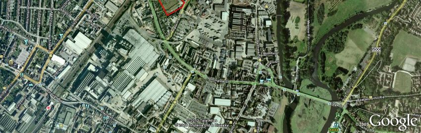
Tesco – Hawkins Lane, Burton-on-Trent
Air Quality Assessment Report

CLIENT AND CONSULTANT CONTACT DETAILS
                                               Client Details
Client                        Tesco Stores Ltd
                              PO Box 400, Cirrus building, Shire Park, Welwyn Garden City, AL7
Address
                              1ZR
Project Manager               Dave Burkey
Tel                           +44 (0)1707 360401
Email                         dave.burkey@uk.tesco.com

                                     Air Quality Consultant Details
Address 1                     Export House, Cawsey Way, Woking, Surrey, GU21 6QX
Address 2                     1 Waterhouse Square, 138-142 Holborn, London, EC1N 2ST
Address 3                     St. Johns House, Queen Street, Manchester, M2 5JB
Project Manager               Mark Chapman
Tel                           +44 (0)1483 731 378
Fax                           +44 (0)1483 731 006
Email                         mark.chapman@mouchel.com
Technical Manager             Ana Grossinho
Tel                           +44 (0)1483 731 510
Fax                           +44 (0)1483 731 006
Email                         ana.grossinho@mouchel.com
Project Team                  Chloe Smith, Fergus Boughton, Thomas Wright, Mark Chapman,
                              Ana Grossinho
Principal Author(s)           Chloe Smith

DOCUMENT CONTROL SHEET
Document Information

Project Name                               Tesco - Hawkins Lane, Burton-on-Trent
Project Number                             1032252-001-001
File Name                                  Tesco_Hawkins_Lane_AQA_Final_021210_Compressed

Mouchel Collaborator\Air Quality & Odour\Live Projects\Tesco - Hawkins Lane, Burton-on-Trent\09 Control of   2
Documents \08 Reporting\Final Report
© Mouchel 2010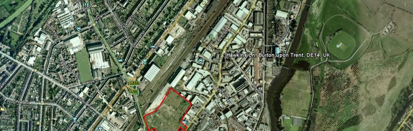
Tesco – Hawkins Lane, Burton-on-Trent
Air Quality Assessment Report

Record of Issue

                                                                      Approved and
                                              Prepared by:
                                                                      Authorised by:
Issue      Status       Description
                                               Name/Dated
                                                                       Signed/Dated

                                               Chloe Smith
                         First report
   1      Final v1                               02/12/10
                       issued to client                                Ana Grossinho           Mark Chapman
                                                                          02/12/10                 02/12/10

Distribution

Organisation                                  Contact                                            Copies

Mark Chapman                                  Mouchel                                            electronic

Ana Grossinho                                 Mouchel                                            electronic

David Burkey                                  TESCO                                              electronic

Mark Aylward                                  DPP                                                electronic

Mouchel Collaborator\Air Quality & Odour\Live Projects\Tesco - Hawkins Lane, Burton-on-Trent\09 Control of    3
Documents \08 Reporting\Final Report
© Mouchel 2010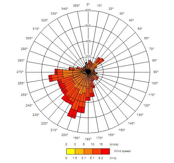
Tesco – Hawkins Lane, Burton-on-Trent
Air Quality Assessment Report

Disclaimer

This Report is presented to Tesco Stores Ltd (the Client) and may not be used or
relied on by any other person or by the Client in relation to any other matters not
covered specifically by the scope of this Report.

Notwithstanding anything to the contrary contained in the Report, Mouchel is obliged
to exercise reasonable skill, care and diligence in the performance of the services
required by the Client and shall not be liable except to the extent that it has failed to
exercise reasonable skill, care and diligence, and this Report shall be read and
construed accordingly.

This Report is based on and incorporates information and data from information
preceding Mouchel’s involvement and Mouchel is unable to defend any inaccuracies
within this information.

This Report has been prepared by Mouchel Limited. No individual is personally liable
in connection with the preparation of this document. By receiving this Report and
acting on it, the Client or any other person accepts that no individual is personally
liable whether in contract, tort, for breach of statutory duty or otherwise.

Any questions or matters arising from this report should be addressed in the first
instance to the Project Manager.

Mouchel Collaborator\Air Quality & Odour\Live Projects\Tesco - Hawkins Lane, Burton-on-Trent\09 Control of   4
Documents \08 Reporting\Final Report
© Mouchel 2010
Tesco – Hawkins Lane, Burton-on-Trent
Air Quality Assessment Report

Contents
EXECUTIVE SUMMARY...............................................................................................9

1      Introduction ......................................................................................................10

1.1    Objectives...........................................................................................................10

1.2    Description of the Proposed Development..........................................................11

1.3    Study Area..........................................................................................................11

2      Legislative Background and Guidance...........................................................13

2.1    Air Quality (England) Regulations 2000 and Air Quality (England) Amendment
       Regulations 2002................................................................................................13

2.2    Planning Policy Statement 23 (PPS23): Planning and Pollution Control .............14

2.3    The Environmental Protection Act 1990 (EPA) ...................................................15

2.4    Best Practice Guidance: Control of Dust Emissions from Construction Activities 16

3      Assessment Methodology ...............................................................................17

3.1    Analysis of Traffic Data.......................................................................................17

3.2    Definition of the Study Area ................................................................................17

3.3    Identification of Relevant Receptors of Public Exposure.....................................17

3.4    Characterisation of Baseline Conditions .............................................................18

3.5    Identification of Hot-spot Locations.....................................................................19

3.6    Background Data................................................................................................19

3.7    Monitoring Data ..................................................................................................19

3.8    Construction Impacts on Local Air Quality ..........................................................25

Mouchel Collaborator\Air Quality & Odour\Live Projects\Tesco - Hawkins Lane, Burton-on-Trent\09 Control of               5
Documents \08 Reporting\Final Report
© Mouchel 2010
Tesco – Hawkins Lane, Burton-on-Trent
Air Quality Assessment Report

3.9    Operation Impacts on Local Air Quality...............................................................28

4      Baseline Conditions.........................................................................................32

4.1    Selected Relevant Receptors of Public Exposure ...............................................32

4.2    Local Air Quality Management Findings .............................................................34

4.3    Background Concentrations ...............................................................................36

4.4    Local Air Quality Monitored Concentrations ........................................................36

5      Results..............................................................................................................39

5.1    Construction Phase ............................................................................................39

5.2    Construction Site Proposed Mitigation Measures................................................42

5.3    Operation Phase.................................................................................................49

6      Conclusions .....................................................................................................58

6.1    Construction Phase ............................................................................................58

6.2    Operation Phase.................................................................................................58

6.3    Overall Impacts on Local Air Quality ...................................................................59

7      References........................................................................................................60

8      Appendices.......................................................................................................62

8.1    Appendix A - Summary of Health Effects of NO2 and PM10 .................................62

8.2    Appendix B - Meteorological Data ......................................................................63

8.3    Appendix C - Detailed Modelling Procedures......................................................64

Mouchel Collaborator\Air Quality & Odour\Live Projects\Tesco - Hawkins Lane, Burton-on-Trent\09 Control of               6
Documents \08 Reporting\Final Report
© Mouchel 2010
Tesco – Hawkins Lane, Burton-on-Trent
Air Quality Assessment Report

Figures
Figure 1 - Location of the Proposed Development ............................................................................. 12
Figure 2 - Location of the Diffusion Tubes Used for Model Verification (ESBC Survey) ....................... 23
Figure 3 - Location of the Diffusion Tubes Within the Vicinity of the Site (ESBC Survey) ..................... 24
Figure 4 - Location of Public Exposure Receptors (including Sensitive Receptors).............................. 33
Figure 5 - Location of AQMAs and Proposed Development Site ......................................................... 35
Figure 6 - Construction Phase Estimated Impact Magnitude Bands (Pre Mitigation Controls) .............. 41
Figure 7 - Construction Phase Estimated Impact Magnitude Bands (Post Mitigation Controls)............. 48
Figure 8 - Do-Minimum NO2 Concentrations...................................................................................... 50
Figure 9 - Do-Something NO2 Concentrations ................................................................................... 51
Figure 10 - Operation Phase Change in NO2 Concentrations ............................................................. 52
Figure 11 - Do-Minimum PM10 Concentrations ................................................................................... 54
Figure 12 - Do-Something PM10 Concentrations................................................................................. 55
Figure 13 - Operation Phase Change in PM10 Concentrations ............................................................ 56
Figure 14 - 2009 Wind Rose for East Midlands Airport Meteorological Station .................................... 63

Mouchel Collaborator\Air Quality & Odour\Live Projects\Tesco - Hawkins Lane, Burton-on-Trent\09 Control of                     7
Documents \08 Reporting\Final Report
© Mouchel 2010
Tesco – Hawkins Lane, Burton-on-Trent
Air Quality Assessment Report

Tables
Table 1 - Relevant Air Quality Objectives/ EU Limit Values ................................................................ 13
Table 2 - Description of Local Authorithy Monitoring Sites Considered for Model Verification in the
     Current Assessment................................................................................................................. 20
Table 3 - Best Practice Guidance Construction Dust Risk Classification ............................................. 26
Table 4 - Construction Impact Magnitude Categories (Source: Mouchel) ............................................ 28
                                                                                                  3
Table 5 - Average Background Concentrations across the Study Area (µg/m ) ................................... 36
                                                           3
Table 6 - Annual Mean NO2 Concentrations (µg/m ) Measured at Continuous Monitors ...................... 36
                                                             3
Table 7 - Annual Mean PM10 Concentrations (µg/m ) Measured at Continuous Monitors..................... 37
Table 8 - Diffusion Tube Monitoring - Annual Mean NO2 Concentrations Measured by ESBC.............. 37
Table 9 - Relevant Receptors Sensitive to Dust Deposition ................................................................ 40
Table 10 - Diffusion Tube Monitoring - Annual Mean NO2 Concentrations Measured by ESBC............ 62
Table 11 - Summary of Traffic Characteristics Data ........................................................................... 66
Table 12 - Summary of Model Conditions for CHP............................................................................. 68
Table 13 - Summary of Car Park Accumulation Data (Friday)............................................................. 68
Table 14 - Summary of Car Park Accumulation Data (Saturday) ........................................................ 69
Table 15 – Three Stage Model Adjustment Factors............................................................................ 71

Mouchel Collaborator\Air Quality & Odour\Live Projects\Tesco - Hawkins Lane, Burton-on-Trent\09 Control of                               8
Documents \08 Reporting\Final Report
© Mouchel 2010
Tesco – Hawkins Lane, Burton-on-Trent Air Quality Assessment Report EXECUTIVE SUMMARY Mouchel Limited was commissioned by Tesco Stores Ltd to undertake an Air Quality Assessment in support of their planning application for the re-development of land at Hawkins Lane, Burton-on-Trent. The current report evaluates the air quality conditions registered in the baseline year (2009) and estimates the likely contributions of the proposed development to local air quality in the opening year (2013) in association with both the construction and operation phases of the development. The proposed development is located within close proximity to two Air Quality Management Areas (AQMAs). Therefore the assessment has also considered the impact of the development on these AQMAs. The main sources of local pollution associated with the construction phase of the development are those of fugitive dust emissions arising from demolition, excavation and materials storing and handling activities. The main sources of pollution arising from the operation phase of the development are those of road traffic emissions associated with changes in the local network traffic characteristics, those arising from vehicles parking at the site, and from the Combined Heat and Power (CHP) unit which is to be installed as part of the development. The construction site was classified as a high risk site with relevant receptors identified as being exposed to major magnitude impacts at the pre mitigation stage. Therefore, a series of hard and soft control measures are recommended to reduce the magnitude of these impacts. Once such mitigation controls are implemented it is estimated that the majority of the receptors will fall under either the minor or negligible magnitude impact categories. Advanced air dispersion modelling was used in the assessment undertaken, taking into account the effects of the car park, the CHP plant and likely changes in traffic characteristics associated with the proposed development. Available local diffusion tube monitoring data provided by East Staffordshire Borough Council (ESBC) were analysed and used for model verification purposes. Analysis of the modelled results indicates that exceedences of the Annual Mean Air Quality Objective for nitrogen dioxide (NO2) and particulate matter (PM10) for both the Do-Minimum and Do-Something Scenarios in the opening year (2013) are unlikely. Overall, this Air Quality Assessment concluded that the proposed development is likely to be compliant with the national and European Air Quality Objectives and Limit Values and, as such, there are no air quality reasons to prevent the local planning authority from granting planning permission. Mouchel Collaborator\Air Quality & Odour\Live Projects\Tesco - Hawkins Lane, Burton-on-Trent\09 Control of 9 Documents \08 Reporting\Final Report © Mouchel 2010
Tesco – Hawkins Lane, Burton-on-Trent
Air Quality Assessment Report

1        Introduction

1.1      Objectives

Mouchel Limited was commissioned by Tesco Stores Ltd to undertake an Air Quality
Assessment in support of their planning application for the re-development of land at
Hawkins Lane, Burton-on-Trent.

This assessment will be undertaken in accordance with the Department for
Environment, Food and Rural Affairs’ (Defra) current Technical Guidance on Local
Air Quality Management (LAQM) (Defra, 2009) and will cover air quality impacts
associated with both the construction and operation phases of the proposed
development.

It is considered that the proposed development may have a temporary effect on local
air quality during construction, with demolition activities, earth-moving works and the
storage of aggregates at the Hawkins Lane Site (hereafter referred to as the Site)
posing the highest risk with respect to the occurrence of ‘nuisance dust’. These
activities are likely to increase the risk of dust entrainment and possible nuisance
occurrence from increased deposition to surrounding surfaces. The assessment of
construction phase impacts will focus on likely impacts of airborne and deposited
particulate matter in the vicinity of the Site. Potential control measures will be
evaluated and recommended to mitigate any estimated risks associated with this
phase of the development.

Changes in local traffic characteristics resulting from the operation of the proposed
development may have an impact on air quality. Vehicle exhaust gases contain a
number of air pollutants. The quantities of each pollutant emitted depend upon the
type and quantity of fuel used, engine size, speed of the vehicle and the type of
emissions abatement equipment fitted. Therefore changes in traffic characteristics
(as a result of the proposed development) may result in changes in pollutant
concentrations at properties near to roads relevant. These will be addressed in the
current assessment.

The operation of a Combined Heat and Power (CHP) natural gas-fired power unit will
result in emissions of carbon dioxide (CO2), water vapour (H2O), oxides of nitrogen
(NO and NO2, generally referred to as NOx), oxides of sulphur (SOx), carbon
monoxide (CO), unburnt hydrocarbons (UHC), and particulate matter (PM10).
However, NOx is likely to be the main emission and its impact on local air quality
(NO2 concentrations) will be assessed in the current exercise.

Finally, the operation of a new car park may have an impact on local air quality and
its associated emissions will equally be considered.

Mouchel Collaborator\Air Quality & Odour\Live Projects\Tesco - Hawkins Lane, Burton-on-Trent\09 Control of   10
Documents \08 Reporting\Final Report
© Mouchel 2010
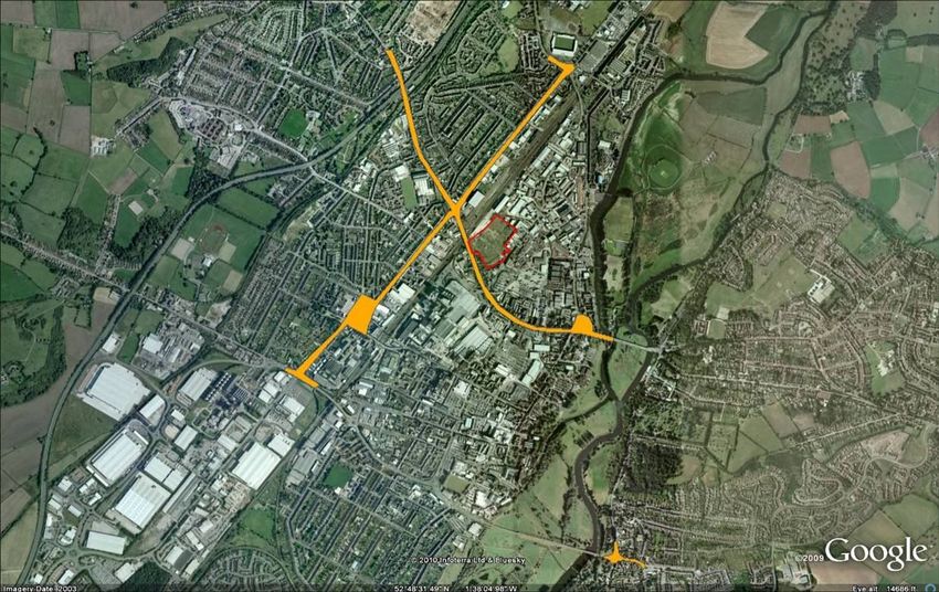
Tesco – Hawkins Lane, Burton-on-Trent
Air Quality Assessment Report

The pollutants NOx/NO2 and PM10/PM2.5 are the main pollutants associated with this
development with relevance for local air quality and will be evaluated in the current
assessment.

The potential impact of the development on local air quality will be assessed on the
basis of the findings of advanced dispersion modelling (ADMS-Roads) calculations,
which will be undertaken in the context of relevant national and European Air Quality
Objectives and Limit values (described in Section 2) and relevant guidance.

1.2      Description of the Proposed Development

The proposed Site works will be undertaken at the existing Alumasc Grundy Site,
Hawkins Lane, Burton-on-Trent. These will consist of the construction of a new Tesco
store with CHP and associated car park, along with vehicle access on this former
Brownfield site.

The proposed development lies within East Staffordshire Borough Council (ESBC) and
will comprise a gross building area of 10,570 m2 and a net sales area of 7,669 m2 with
associated car parking and a CHP unit. The re-development of the site is proposed for
B1 (Business), B2 (General Industry) and B8 (Storage and Distribution) use, with trade
facilities and the construction of a new vehicular access.

1.3      Study Area

The Site is situated on a vacant Brownfield site, which is located approximately 0.7 km
to the north west of the centre of Burton-on-Trent and to the west of the River Trent.
The site is bound by Hawkins Lane to the east and Horninglow Street to the south,
with the major trunk road (A38) located approximately 1.2 km to the north of the site.

The nearest bus stop to the Site is located along Horninglow Street to the west. This
bus stop is served regularly by services from across the area. There are also
proposals in place for a hopper bus service associated with the development.

Figure 1 presents the location of the proposed development in Burton-on-Trent.

Mouchel Collaborator\Air Quality & Odour\Live Projects\Tesco - Hawkins Lane, Burton-on-Trent\09 Control of   11
Documents \08 Reporting\Final Report
© Mouchel 2010
Tesco – Hawkins Lane, Burton-on-Trent
Air Quality Assessment Report

                                                                                                                                                                       LEGEND

                                                           Description:                                                   Design           CS     10/09/2010
                        Client:
                                                     Location of the Proposed
                    Tesco Stores Ltd
                                                           Development
                                                                                              Google Earth                Drawn            CS     10/09/2010
                                                                                           © 2010 Tele Atlas
                                                                                      © 2010 Infoterra Ltd & Bluesky
                                                            Project:                                                     Checked          MIC     01/12/2010            Figure 1
            Rev:            Description:
                                                      Tesco Hawkins Lane,
             A                FINAL
                                                        Burton-on-Trent
                                                                                                                         Approved          AG     01/12/2010   Scale          Not to Scale

                                                                    Figure 1 - Location of the Proposed Development

Mouchel Collaborator\Air Quality & Odour\Live Projects\Tesco - Hawkins Lane, Burton-on-Trent\09 Control of Documents \08 Reporting\Final Report                          12
© Mouchel 2010
Tesco – Hawkins Lane, Burton-on-Trent
Air Quality Assessment Report
2 Legislative Background and Guidance
2.1 Air Quality (England) Regulations 2000 and Air Quality (England)
Amendment Regulations 2002
The UK Government and the devolved administrations published the latest Air
Quality Strategy for England, Scotland, Wales and Northern Ireland in July 2007
(Defra, 2007a) defining both the standards and objectives for each of a range of air
pollutants.
The ‘standards’ are set as concentrations below which health effects are unlikely
even in sensitive population groups, or below which risks to public health would be
exceedingly small. They are based purely upon the scientific and medical evidence
of the effects of a particular pollutant.
The ‘objectives’ set out the extent to which the Government expects the standards to
be achieved by a certain date. They take account of the costs, benefits, feasibility
and practicality of achieving the standards. The objectives are prescribed within The
Air Quality (England) Regulations 2000 (Stationery Office, 2000) and The Air Quality
(England) (Amendment) Regulations 2002 (Stationery Office, 2002) (termed the
‘Regulations’). Air Quality Objectives included in the Regulations and current
legislation (CAFE Directive) which are relevant to the current study (NO2 and PM10)
are outlined in Table 1.
Table 1 - Relevant Air Quality Objectives/ EU Limit Values
Air Quality Objective/EU Limit Value To be achieved by:
Pollutant Measured
Concentration Regulation EU Limit
as
Nitrogen Dioxide (NO2)
3
200 µg/m , not to be exceeded 31 December
1 Hour Mean
more than 18 times a year 2005
All UK 2010
3 31 December
40 µg/m Annual Mean
2005
Particulate Matter (PM10) (gravimetric)
50 µg/m3, not to be exceeded 24 Hour31 December
more than 35 times a year Mean 2004
All UK
3 31 December
40 µg/m Annual Mean
2004
Particulate Matter (PM2.5) (gravimetric)*
3
25 µg/m (target) Annual Mean 2020
All UK 15% cut in urban background
Annual Mean 2010 - 2020
exposure
Note: * Not included in Regulations at present.
Mouchel Collaborator\Air Quality & Odour\Live Projects\Tesco - Hawkins Lane, Burton-on-Trent\09 Control of 13
Documents \08 Reporting\Final Report
© Mouchel 2010Tesco – Hawkins Lane, Burton-on-Trent
Air Quality Assessment Report
Appendix A provides a brief summary of the health effects of NO2 and PM10.
The Air Quality Objectives only apply where members of the public are likely to be
regularly present for the averaging time of the objective (i.e. where people will be
exposed to pollutants). The annual mean objectives apply to all locations where
members of the public might be regularly exposed; these include building façades of
residential properties, schools, hospitals, care homes etc. The 24 hour mean
objective applies to all locations where the annual mean objective would apply,
together with hotels and gardens of residential properties1. The 1 hour mean
objective also applies at these locations as well as at any outdoor location where a
member of the public might reasonably be expected to stay for 1 hour or more, such
as shopping streets, parks and sports grounds, as well as bus stations and railway
stations that are not fully enclosed.
Measurements across the UK have shown that the 1 hour mean NO2 objective is
unlikely to be exceeded unless the annual mean NO2 concentration is greater than
60 µg/m3 (Laxen and Marner, 2003). Thus exceedences of 60 µg/m3 as an annual
mean NO2 concentration are used as an indicator of potential exceedences of the 1
hour mean NO2 objective.
Similarly, studies (Defra, 2003) have also established a relationship between the
annual mean PM10 concentration and number of exceedences of the 24 hour mean
objective: those areas where the annual mean concentrations is greater than
32 µg/m3 were demonstrated to be at risk of exceeding the 24 hour mean objective.
Thus exceedences of 32 µg/m3 as an annual mean PM10 concentration are used as
an indicator of potential exceedences of the 24 hour mean PM10 objective.
2.2 Planning Policy Statement 23 (PPS23): Planning and Pollution
Control
PPS23 is guidance which covers planning and pollution control and new
development in England. PPS23 advises on the policies and practices that should be
taken into account by those involved in the planning of any development that has the
potential to cause pollution. Annex 1, Paragraph 1.48 states…
“planning conditions could be used in respect of […] impacts such as noise,
vibrations, odour, air pollutants and dust from certain phases of the development
such as demolition and construction”.
1
Such locations should represent parts of the garden where relevant public exposure is likely, for example where
there are seating or play areas. It is unlikely that relevant public exposure would occur at the extremities of the
garden boundary, or in front gardens, although local judgement should always be applied.
Mouchel Collaborator\Air Quality & Odour\Live Projects\Tesco - Hawkins Lane, Burton-on-Trent\09 Control of 14
Documents \08 Reporting\Final Report
© Mouchel 2010Tesco – Hawkins Lane, Burton-on-Trent
Air Quality Assessment Report
(ODPM, 2004)
2.3 The Environmental Protection Act 1990 (EPA)
Dust and air pollution, can cause nuisance affecting properties and the public
adjacent to a construction site and can also adversely affect other environmental
receptors including watercourses and ecological receptors. In addition, there are
statutory objectives in relation to NO2 and PM10 which have known health impacts.
The EPA (Section 79, Chapter 43, Part III - Statutory Nuisances and Inspections)
contains a definition of what constitutes a ‘statutory nuisance’ with regard to dust,
and places a duty of care on Local Authorities to detect any such nuisances within
their area. Section 79 of the Act further defines “Best Practicable Means” (BPM)
as…
“reasonably practical having regard, among other things, to local conditions and
circumstances, to the current state of technical knowledge and to the financial
implications”.
(EPA, 1990)
It also defines a number of factors relating to dust and air pollution which constitute a
statutory nuisance. These include:
i. smoke emitted from premises so as to be prejudicial to health or a nuisance;
ii. fumes or gases emitted from premises so as to be prejudicial to health or a
nuisance;
iii. any dust, steam, smell or other effluvia arising on industrial, trade or business
premises and being prejudicial to health or a nuisance; and
iv. any accumulation or deposit which is prejudicial to health or a nuisance.
Local Authorities have the power under Section 80, Chapter 43, Part III of the EPA
(Summary Proceedings for Statutory Nuisances) to serve an abatement notice
requiring the abatement of a nuisance or requiring works to be executed to prevent
their occurrence. Generally, if something is unreasonable to an average person, a
court may decide that it is a nuisance. A typical example of statutory nuisance is dust
produced by construction activities.
Mouchel Collaborator\Air Quality & Odour\Live Projects\Tesco - Hawkins Lane, Burton-on-Trent\09 Control of 15
Documents \08 Reporting\Final Report
© Mouchel 2010Tesco – Hawkins Lane, Burton-on-Trent Air Quality Assessment Report 2.4 Best Practice Guidance: Control of Dust Emissions from Construction Activities The Greater London Authority and London Councils published this Best Practice Guidance document in November 2006 (London Councils, 2006). While it is specifically aimed at developments in London, it is the most comprehensive guidance document available, and the Environment Agency (EA) and others are encouraging its use across the country. The basic principles to be applied in the selected approach are the targeted prevention, suppression and containment of emissions. This document is used in line with Annex 1 of the Minerals Policy Statement (OPDM, 2005) which gives examples of reducing and controlling dust, and outlines good practice in dust assessment. These documents together with Mouchel’s professional judgement were used to localise and evaluate the potential construction impacts associated with the proposed development. Mouchel Collaborator\Air Quality & Odour\Live Projects\Tesco - Hawkins Lane, Burton-on-Trent\09 Control of 16 Documents \08 Reporting\Final Report © Mouchel 2010
Tesco – Hawkins Lane, Burton-on-Trent
Air Quality Assessment Report

3        Assessment Methodology

3.1      Analysis of Traffic Data

Data were provided by Transport Planning Associates (TPA) and included daily
flows, speed information and composition. These data were analysed and
processed for the baseline (2009) and opening year (2013) for the Do-Minimum
(DM) and Do-Something (DS) scenarios. The data included:

        i. annual average daily traffic flows (AADT, combined - vehicle/day) for
           relevant links;
       ii. the percentage of Heavy Duty Vehicles (HDVs) (vehicles > 3.5t Gross
           Vehicle Weight) on each of the roads for each year modelled;
       iii. the daily average speed (kph) on the relevant roads for each year
            modelled; and
      iv. road type.

3.2      Definition of the Study Area

To ensure consistency with the Local Authority LAQM modelling approach and to
make sure the AQMAs were addressed suitably in the current exercise, the full
extent of the study area was determined by the roads considered in ESBCs Further
Assessment report (ESBC, 2008). These roads were considered to be relevant for
the current Air Quality Assessment and all relevant receptors within 200m of these
links were selected and included in the model.
This procedure defined the study area for local air quality purposes.

3.3      Identification of Relevant Receptors of Public Exposure

The Regulations require that likely exceedences of Air Quality Objectives are
assessed in relation to:

“…the quality of the air at locations which are situated outside of buildings or other
natural or man-made structures, above or below ground, and where members of the
public are regularly present…”.

                                                                   (Stationery Office, 2000 and 2002)

Existing and planned properties where people might experience a change in local air
quality within 200m of the relevant roads were identified. This included a clear
identification of properties hosting susceptible groups of the public (establishment of

Mouchel Collaborator\Air Quality & Odour\Live Projects\Tesco - Hawkins Lane, Burton-on-Trent\09 Control of   17
Documents \08 Reporting\Final Report
© Mouchel 2010
Tesco – Hawkins Lane, Burton-on-Trent
Air Quality Assessment Report
locations of any receptors that may be sensitive to changes in air quality during the
construction and operation phases of the development - e.g. schools, hospitals,
homes for the elderly, residential properties, etc.). Representative receptors of such
locations were subsequently selected and used in the model.
Overall 7,302 relevant receptors (including sensitive locations such as nurseries and
schools) were identified using MasterMap Address Layer 2 data and mapped onto
the Ordnance Survey base map using a Geographic Information System (GIS) and
then modelled to ascertain annual mean concentrations of NO2 and PM10.
These relevant receptor locations were considered site representative of locations
where members of the public are exposed for a period of time appropriate to the
averaging period of the objective.
3.4 Characterisation of Baseline Conditions
The identification of baseline air quality conditions in and around the proposed
development included:
i. review of LAQM information:
evaluation of the most readily available LAQM Assessment Reports to
ascertain the existence, location and extent of any AQMAs and
ascertain air quality trends in the study area;
ii. analysis of local air quality monitoring data:
this entailed obtaining and reviewing local pollutant monitoring data held
by the Local Authority. Local Authority and National AURN (Automatic
Urban and Rural Network) monitoring data for NO2 and PM10 were
analysed for location and type of station, pollutant measured, data
capture, validity and values recorded; and
iii. background concentrations:
this comprised a review of estimated Annual Mean background
pollutant concentrations (available online at the UK National Air Quality
Information Archive (NAQIA)2). Estimated background pollution
concentrations were derived from the national maps (1 km x 1 km
spatial resolution) and used in the assessment for the baseline year
2009 and opening year 2013.
2
http://www.airquality.co.uk/archive/index.php - Accessed 19/08/10
Mouchel Collaborator\Air Quality & Odour\Live Projects\Tesco - Hawkins Lane, Burton-on-Trent\09 Control of 18
Documents \08 Reporting\Final Report
© Mouchel 2010Tesco – Hawkins Lane, Burton-on-Trent
Air Quality Assessment Report
3.5 Identification of Hot-spot Locations
Areas likely to experience higher-than-average pollution concentrations, such as
roundabouts and junctions, were identified and assessed accordingly.
3.6 Background Data
Background concentrations of NO2 and PM10 within the study area for the baseline
and opening years have been derived from national maps (1 km x 1 km spatial
resolution) of Annual Mean background concentrations available from the NAQIA
(Defra, 2007b).
Total background concentrations from Defra were disaggregated to provide relative
contributions from different sources. The contributions of emissions from trunk ‘A’
roads and primary ‘A’ roads have been excluded from total background
concentrations used in the assessment as these have been explicitly modelled in the
current exercise. Where industrial sources have also been explicitly modelled as
part of the DS scenario, these have also been removed from the total. Contributions
from the ‘Out grid’ component were left within the total backgrounds.
Due to the large model study area and the need for receptor specific concentrations,
ArcGIS 9.3 was used to select the nearest background to the relevant receptor. This
ensured that the background concentrations were selected for the actual grid square
where the receptors were located.
3.7 Monitoring Data
3.7.1 Continuous Monitoring Data
ESBC has two automatic monitoring stations located at St. Peters Bridge and Derby
Turn monitoring NOx/NO2 and PM10. The Derby Turn monitoring station is located
approximately 195m of the north west to the site and the St. Peters Bridge
monitoring station is located approximately 1.4 km to the south-east of the Site.
Monitored concentrations were analysed and evaluated for suitability for both model
verification and indication of local conditions in this assessment.
Mouchel Collaborator\Air Quality & Odour\Live Projects\Tesco - Hawkins Lane, Burton-on-Trent\09 Control of 19
Documents \08 Reporting\Final Report
© Mouchel 2010Tesco – Hawkins Lane, Burton-on-Trent
Air Quality Assessment Report
3.7.2 Passive Monitoring Data
ESBC currently manages a network of diffusion tubes measuring NO2 concentrations
across their area of jurisdiction.
Thirty eight (38) of these locations were evaluated and considered suitable for model
verification purposes in the current assessment in terms of location, data quality and
capture. These were within close proximity to the Site and the modelled road
network. Table 2 provides a description of these sites.
Table 2 - Description of Local Authorithy Monitoring Sites Considered for Model Verification in the
Current Assessment
Site Site X Y
Site Description
Number Type (m) (m)
1 and 2 Trent Bridge Duplicates Roadside 425362 323339
3 and 4 St Peters Bridge Duplicates Roadside 425575 322028
7 Horninglow Croft Roadside 424367 324781
11, 12 Wellington Street Kerbside 423953 323280
13 Horninglow Street Roadside 424796 323624
14 Derby Turn Roadside 424632 324043
15 Derby Turn Kerbside 424636 324037
21 Horninglow Road - approaching A38 flyover Kerbside 424404 324481
22 Horninglow Road / Parker St Junction Roadside 424537 324228
23 Derby Street - nr to Derby Turn Kerbside 424581 323963
25 Derby Street / Byrkley St junction Roadside 424212 323473
A444 - Stapenhill - Approaching junction with
26 Kerbside 425706 321902
Violet Way
27 Princess Way Roundabout Roadside 425235 324854
Derby Road - Approaching Princess Way Roadside
28 425161 324737
Roundabout
29 Derby Road/ Eton Road junction Roadside 425107 324668
30 Sydney Street - nr. Junction with Derby Rd Roadside 424970 324505
31 Derby Road - Approaching Derby Turn Roadside 424709 324140
Mouchel Collaborator\Air Quality & Odour\Live Projects\Tesco - Hawkins Lane, Burton-on-Trent\09 Control of 20
Documents \08 Reporting\Final Report
© Mouchel 2010Tesco – Hawkins Lane, Burton-on-Trent
Air Quality Assessment Report
Site Site X Y
Site Description
Number Type (m) (m)
32 Derby Street - Approaching Derby Turn Roadside 424547 323940
34 Derby Street - Maltings Court Roadside 424351 323660
35 Albert St - nr. Junction with Derby St Roadside 424322 323674
36 Derby Street - Appr Little Burton West Roadside 424453 323794
37 Byrkley St - nr Princess St Roadside 424194 323508
Waterloo Street - Approaching junction with
38 Kerbside 424116 323483
Byrkley Street
Derby Street - opposite Midland Grain Roadside
39 424149 323344
Warehouse
40 Wellington Street - Crossing Roadside 423993 323308
Curzon Street - nr. Junction with Wellington Roadside
41 423951 323216
Street
42 Wellington Street - roundabout Roadside 423812 323077
43 Wellington Street - Approaching roundabout Roadside 423807 323115
44 Wellington Street - roundabout Roadside 423784 323099
Rolleston Road - nr junction with Horninglow Roadside
46 424113 325209
Road
Shakespeare Road - nr junction with Roadside
49 424417 324579
Horninglow Road
Goodman Street - nr Junction Horninglow Roadside
50 424621 324142
Road
52 Horninglow Street - Bridge Roadside 424752 323748
Horninglow Street - nr junction with Wetmore Roadside
53 425270 323346
Road
54 Horninglow Street - nr junction with High Street Roadside 425275 323327
55 Bridge Street - nr Old Bridge Roadside 425345 323321
58 Belvedere Rd - A38 flyover Roadside 423834 324316
59 Shobnall Rd - A38 flyover Roadside 422908 323540
Mouchel Collaborator\Air Quality & Odour\Live Projects\Tesco - Hawkins Lane, Burton-on-Trent\09 Control of 21
Documents \08 Reporting\Final Report
© Mouchel 2010Tesco – Hawkins Lane, Burton-on-Trent Air Quality Assessment Report Figures 2 and 3 show the location of these monitoring sites across the study area and in the vicinity of the site respectively. Mouchel Collaborator\Air Quality & Odour\Live Projects\Tesco - Hawkins Lane, Burton-on-Trent\09 Control of 22 Documents \08 Reporting\Final Report © Mouchel 2010
Tesco – Hawkins Lane, Burton-on-Trent
Air Quality Assessment Report

                                                                                                                                                           LEGEND

                                                                         This map is reproduced from Ordnance
                                               Description:              Survey material with the permission of     Design    CS      28/09/2010
              Client:                 Location of the Diffusion Tubes      Ordnance Survey on behalf of the
          Tesco Stores Ltd           Used for Model Verification (ESBC    Controller of Her Majesty’s Stationery
                                                  Survey)                                 Office.                   Drawn     CS      28/09/2010

                                                                          © Crown Copyright. Licence number
                                                                                      100020449                    Checked    MIC     02/12/2010            Figure 2
                                                 Project:                 Unauthorised reproduction infringes
  Rev:            Description:
                                           Tesco Hawkins Lane,             Crown copyright and may lead to
   A                FINAL
                                             Burton-on-Trent                prosecution or civil proceedings.      Approved   AG      02/12/2010   Scale        Not to Scale

                                                Figure 2 - Location of the Diffusion Tubes Used for Model Verification (ESBC Survey)

Mouchel Collaborator\Air Quality & Odour\Live Projects\Tesco - Hawkins Lane, Burton-on-Trent\09 Control of Documents \08 Reporting\Final Report                                23
© Mouchel 2010
Tesco – Hawkins Lane, Burton-on-Trent
Air Quality Assessment Report
LEGEND
This map is reproduced from
Description: Ordnance Survey material with the Design CS 28/09/2010
Client: Location of the Diffusion Tubes permission of Ordnance Survey on
Tesco Stores Ltd Within the Vicinity of the Site behalf of the
(ESBC Survey) Controller of Her Majesty’s Stationery Drawn CS 28/09/2010
Office.
© Crown Copyright. Licence number
100020449 Checked MIC 02/12/2010 Figure 3
Project:
Rev: Description: Unauthorised reproduction infringes
Tesco Hawkins Lane,
A FINAL Crown copyright and may lead to
Burton-on-Trent
prosecution or civil proceedings. Approved AG 02/12/2010 Scale Not to Scale
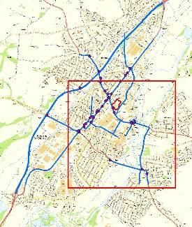
Figure 3 - Location of the Diffusion Tubes Within the Vicinity of the Site (ESBC Survey)
Mouchel Collaborator\Air Quality & Odour\Live Projects\Tesco - Hawkins Lane, Burton-on-Trent\09 Control of Documents \08 Reporting\Final Report 24
© Mouchel 2010Tesco – Hawkins Lane, Burton-on-Trent Air Quality Assessment Report 3.8 Construction Impacts on Local Air Quality During the construction phase, there will be a number of activities undertaken that have the potential to generate and/or re-suspend dust and PM10/PM2.5. At the time of assessment the exact activities to be undertaken during construction are unknown. In order to evaluate the magnitude and extent of potential adverse impacts likely to result from the proposed development, the following construction activities have therefore been assumed: i. site clearance and preparation; ii. storage of materials; iii. laying of hard surfaces; and iv. landscaping. The magnitude of potential impacts of a construction site on air quality is mainly determined by its size, the range of activities undertaken across the site, proximity to sensitive receptors, prevailing wind direction, complexity of terrain and any barriers between sources and receptors. These are addressed in turn in the following sub- sections. 3.8.1 Risk of the Site Best Practice guidance issued by the London Councils (2006) provides guidelines that allow the evaluation of potential risk of air quality impacts occurring during the demolition or construction of a site. A summary of these details is presented in Table 3. Mouchel Collaborator\Air Quality & Odour\Live Projects\Tesco - Hawkins Lane, Burton-on-Trent\09 Control of 25 Documents \08 Reporting\Final Report © Mouchel 2010
Tesco – Hawkins Lane, Burton-on-Trent
Air Quality Assessment Report

                   Table 3 - Best Practice Guidance Construction Dust Risk Classification
      Risk Category                                                   Criteria

      Low Risk Site              Development of up to 1,000 square metres of land; or

  (Small Developments)           Development of one property and up to a maximum of ten; or

                                 Potential for emissions and dust to have an infrequent impact on
                                 sensitive receptors.

    Medium Risk Site             Development of between 1,000 and 15,000 square metres of land;
                                 or
      (Medium Sized
      Developments)              Development of between ten and 150 properties; or

                                 Potential for emissions and dust to have an intermittent or likely
                                 impact on sensitive receptors.

      High Risk Site             Development of greater than 15,000 square metres of land; or

(Large Developments or           Development of greater than 150 properties; or
    Developments of
 Strategic Importance)           Major development referred to Central Government; or

                                 Major development as defined by the Local Planning Authority; or

                                 Potential for emissions and dust to have a significant impact on
                                 sensitive receptors.

These guidelines were designed to be applied in London, which is very densely built
and often has multiple construction sites in close proximity. As such, professional
judgment was applied to these criteria in order to ensure that the risk evaluation
reflected site specific characteristics.

3.8.2    Analysis of Distance from Source to Near-by Receptors

Distance bands were created from the boundaries of the site to account for likelihood
of levels of dust and PM10/PM2.5 originated by construction related activities. The
distance classes considered were 0-50m, 50-100m, 100-200 and greater than 200m.
Mouchel Collaborator\Air Quality & Odour\Live Projects\Tesco - Hawkins Lane, Burton-on-Trent\09 Control of   26
Documents \08 Reporting\Final Report
© Mouchel 2010
Tesco – Hawkins Lane, Burton-on-Trent Air Quality Assessment Report These distance bands were then combined with the magnitude of construction risks and the prevailing wind conditions of the site to ascertain the order of impact of the estimated impacts associated with the construction activities of the proposed development. 3.8.3 Prevailing Wind Conditions Meteorological data for 2009 from East Midlands Airport meteorological station were assumed representative of the study area and analysed for wind speed and direction. A wind rose was produced to ascertain the likelihood of receptors to be affected by dust resulting from construction activities and is shown in Appendix B. These data were also used in the dispersion modelling exercise. 3.8.4 Barriers between Emission Sources and Receptors The existence and location of any barriers between emission sources and receptors was ascertained and evaluated. This enabled the evaluation of risk of nuisance associated with downwind emissions and the selection of suitable mitigation measures wherever such need was identified. 3.8.5 Estimation of Magnitude of Impacts Based on the London Councils’ guidance and the spatial extent of effects, the Impact Criteria detailed in Table 4 have been developed by Mouchel for assessment of construction phase impacts. Mouchel Collaborator\Air Quality & Odour\Live Projects\Tesco - Hawkins Lane, Burton-on-Trent\09 Control of 27 Documents \08 Reporting\Final Report © Mouchel 2010
Tesco – Hawkins Lane, Burton-on-Trent
Air Quality Assessment Report

                                Table 4 - Construction Impact Magnitude Categories (Source: Mouchel)

                                                                    Risk from Development
                                                     Low                    Medium                      High

                                                Outside zone of         Outside zone of          Outside zone of
                              >200m
  Distance to Receptors

                                                   influence                influence                  influence

                             100 - 200m           Negligible                 Minor                     Moderate

                             50 - 100m              Minor                  Moderate                     Major

                              0 - 50m              Moderate                  Major                      Major

The 200 m distance criteria is based on the distance beyond which no significant
impacts are expected from road traffic and construction dust (HA, 1993). The 100 m
distance criteria is based on guidance which identifies that the majority of dust is
deposited within 100 m of the emission source (ODPM, 2005). The 50 m criteria are
based on a study showing that half of people living beside construction works were
bothered by nuisance (HA, 1993).

Further than 200m is generally considered to be outside of the zone of influence;
however there is still the possibility that nuisance may occur during atypical
meteorological conditions.

The impact criteria were used to identify possible mitigation measures appropriate for
dust management purposes during the construction phase of the proposed
development. Allowance was made for the number of receptors per distance band and
the prevailing wind direction when control or mitigation measures were being
considered based on these impact criteria.

For receptors upwind of the site, and where physical barriers were identified between
emission sources and potential receptors, the impact category was reduced by one
level.

3.9                       Operation Impacts on Local Air Quality

The store proposals include the installation of a CHP plant to power the Store, new car
parking facilities and a Petrol Filling Station (PFS). This assessment therefore
considered the combined effect of the CHP plant and road traffic impacts (including the
car park contributions and PFS access) on local air quality at relevant receptor
locations representative of public exposure within 200m of the modelled road network.

Mouchel Collaborator\Air Quality & Odour\Live Projects\Tesco - Hawkins Lane, Burton-on-Trent\09 Control of         28
Documents \08 Reporting\Final Report
© Mouchel 2010
Tesco – Hawkins Lane, Burton-on-Trent Air Quality Assessment Report Following the 2009 Local Air Quality Management Technical Guidance (LAQM.TG(09)) guidance, there is no requirement to assess the impact of the PFS on concentrations of Benzene (C6H6) emissions, because from 1st January 2010 all new PFS with a petrol throughput of >500m3/yr are to be fitted with Stage 2 recovery systems. The increase in traffic as part of the PFS will be assessed as part of the road traffic assessment. 3.9.1 Traffic Data 2009 and 2013 traffic flow data were used as input to the ADMS-Roads model for the baseline year and for the opening year DM and DS scenarios. Further information regarding the traffic data used in the current assessment is provided in Appendix C. 3.9.2 CHP The proposals include the installation of a CHP plant to power the Store. The plant is expected to provide an electricity output of 228 kW. The CHP plant will be fuelled by natural gas, and the main emissions modelled were NOx to estimate local air quality impacts on NO2 concentrations. The assessment therefore modelled the CHP plant emissions at relevant public exposure locations in close proximity to the store. A technical data sheet for the proposed CHP plant was received providing input data for the modelling exercise. As the details of the CHP operation were not available, it was assumed that the plant will run at full load, continuously throughout the year. In reality, this is an unlikely scenario which provides an over-estimate of operational conditions and therefore a worst case scenario. Furthermore, a source diameter of 0.2m has been assumed, as estimated from the design drawing provided by the Client for a similar store design. Further information on CHP input data used in the current assessment are provided in Appendix B. 3.9.3 Car Park The proposed development site will provide a total of 631 car parking spaces (this amount was updated after the car park assessment was carried out). The emissions associated with the proposed new store car park were modelled assuming the car park surface as an area source in the ADMS-Roads. Further information on car park input data used in the current assessment are provided in Appendix B. Mouchel Collaborator\Air Quality & Odour\Live Projects\Tesco - Hawkins Lane, Burton-on-Trent\09 Control of 29 Documents \08 Reporting\Final Report © Mouchel 2010
Tesco – Hawkins Lane, Burton-on-Trent
Air Quality Assessment Report

3.9.4         Modelling

Annual Mean concentrations of NO2 and PM10 during 2009 and 2013 have been
modelled using the ADMS-Roads. ADMS-Roads is one of the dispersion models
accepted for modelling within the Government’s Technical Guidance (Defra, 2009).
The model has been run using a full year of meteorological data for 2009 from the East
Midlands Airport meteorological station which is approximately 19 km east of Burton-
on-Trent. Appendix C presents the wind rose for the meteorological conditions
modelled in the current assessment.

Concentrations were modelled for relevant locations of public exposure (including
sensitive receptors). The modelling methodology, and the input data (traffic data, CHP
and car park emissions) utilised are described in further detail in Appendix B. The
model was verified against local diffusion tube measurements and its performance
evaluated to ascertain whether an adjustment of the results obtained was required.

3.9.5    Data Uncertainty

There is an element of uncertainty in all measured and modelled data. All values
presented in this report are the best possible estimates given the data and tools
available, but uncertainties in the results might cause over-predictions or under-
predictions in the data. All of the measurements presented in this report have an
intrinsic margin of error. Defra (2009) suggest that this is of the order of plus or minus
20% for diffusion tube data and plus or minus 10% for automatic measurements. The
model results rely on traffic count data, and predictions of future traffic flows, and thus
any uncertainties inherent in these data sets will carry into this assessment.

There will be additional uncertainties introduced because the modelling has simplified
real-world processes into a series of algorithms. For example, it has been assumed
that:

   i. during each year, the vehicle fleet within the study area will conform to the
      national (UK) average composition;

  ii. the emissions per vehicle conform to the factors published in the Emissions
      Factor Toolkit Version 4.2.2;

  iii. wind conditions measured at the meteorological station during 2009 will occur
       throughout the study area during 2013; and

 iv. the subsequent dispersion of emitted pollutants will conform to a Gaussian
     distribution over flat terrain.

Mouchel Collaborator\Air Quality & Odour\Live Projects\Tesco - Hawkins Lane, Burton-on-Trent\09 Control of   30
Documents \08 Reporting\Final Report
© Mouchel 2010
Tesco – Hawkins Lane, Burton-on-Trent Air Quality Assessment Report An important step in the assessment is verifying the dispersion model against the measured data. By comparing the model results with actual measurements, data will be adjusted for any under or over-prediction. The UK Government’s Air Quality Expert Group (AQEG) has published a report on trends in primary NO2 in the UK (AQEG, 2007). This examines evidence that shows that while NOx emissions have fallen in line with predictions made a decade previously, the composition of NOx has, in some urban environments, changed. This may have caused NO2 concentrations at some locations to fall less rapidly than was expected. The latest guidance from Defra has been followed regarding NOx to NO2 relationships, but there is still uncertainty as to whether these relationships will continue to apply in 2013. Any effect is likely to be greatest close to major roads, where future concentrations may have been underestimated. These limitations to the assessment are considered when reviewing the results set out in the following Sections. While the model should give an overall accurate picture, i.e. one without bias, there will be uncertainties for individual receptors. Clearly in future years the uncertainties are likely to be greater than they are at present. The results are ‘best estimates’ and have therefore been treated as such in the discussion. Mouchel Collaborator\Air Quality & Odour\Live Projects\Tesco - Hawkins Lane, Burton-on-Trent\09 Control of 31 Documents \08 Reporting\Final Report © Mouchel 2010
Tesco – Hawkins Lane, Burton-on-Trent
Air Quality Assessment Report

4        Baseline Conditions

4.1      Selected Relevant Receptors of Public Exposure

Figure 4 presents the locations of the selected receptors representative of public
exposure.

Mouchel Collaborator\Air Quality & Odour\Live Projects\Tesco - Hawkins Lane, Burton-on-Trent\09 Control of   32
Documents \08 Reporting\Final Report
© Mouchel 2010
Tesco – Hawkins Lane, Burton-on-Trent
Air Quality Assessment Report

                                                                                                                                                          LEGEND

                                                                         This map is reproduced from Ordnance
                                                 Description:            Survey material with the permission of     Design    CS    18/11/2010
                Client:                  Location of Public Exposure       Ordnance Survey on behalf of the
            Tesco Stores Ltd            Receptors (including Sensitive    Controller of Her Majesty’s Stationery
                                                 Receptors)                               Office.                   Drawn     CS    18/11/2012

                                                                          © Crown Copyright. Licence number
                                                                                      100020449                    Checked    MIC   01/12/2010             Figure 4
                                                  Project:                Unauthorised reproduction infringes
    Rev:            Description:
                                            Tesco Hawkins Lane,            Crown copyright and may lead to
     A                FINAL
                                              Burton-on-Trent               prosecution or civil proceedings.      Approved   AG    01/12/2010    Scale       Not to Scale

                                                  Figure 4 - Location of Public Exposure Receptors (including Sensitive Receptors)

Mouchel Collaborator\Air Quality & Odour\Live Projects\Tesco - Hawkins Lane, Burton-on-Trent\09 Control of Documents \08 Reporting\Final Report                              33
© Mouchel 2010
You can also read