Ballinasloe Local Area Plan 2015-2021 - Stage 2 Strategic Flood Risk Assessment of the - Galway County ...
←
→
Page content transcription
If your browser does not render page correctly, please read the page content below
Stage 2 Strategic Flood Risk
    Assessment of the
Ballinasloe Local Area Plan
        2015-2021

                    Prepared by Arup
                      Consultants for
               Galway County Council
                     November 2015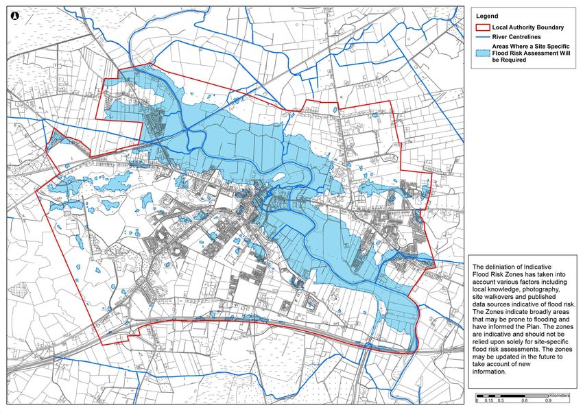
Galway County Council
                                                                         Ballinasloe Local Area Plan 2015-
                                                                         2021
                                                                         Strategic Flood Risk Assessment
                                                                         4-04-03

                                                                         Issue 1 | 5 November 2015

This report takes into account the particular instructions and
requirements of our client.
The maps produced as part of this study were prepared for the purpose
of informing the Ballinasloe Local Area Plan 2015-2021 and broadly
indicate areas that may be prone to flooding. The study has taken into
account various factors including local knowledge, photography, site
walkovers and published data sources indicative of flood risk. The
Indicative Flood Risk Zones should not be solely relied upon for site-
specific flood risk assessments.

Job number        240963-00

Ove Arup & Partners Ireland Ltd
15 Oliver Plunkett Street
Cork
Ireland
www.arup.com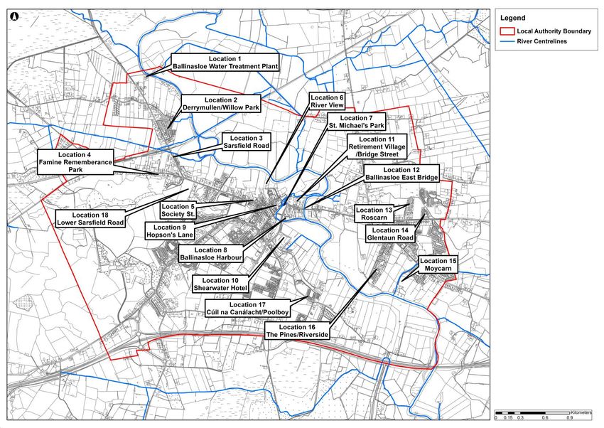
Document Verification
Job title Ballinasloe Local Area Plan 2015-2021 Job number
240963-00
Document title Strategic Flood Risk Assessment File reference
4-04-03
Document ref 4-04-03
Revision Date Filename 20150223_240963_Ballinasloe_SFRA_DRAFT_V1.docx
Draft 1 2 March Description First Draft
2015
Prepared by Checked by Approved by
Name Alan Leen Ken Leahy Ken Leahy
Signature
Draft 2 27 Mar Filename 20150325_240963_Ballinasloe_SFRA_DRAFT_V2.docx
2015 Description Draft for Public Consultation
Prepared by Checked by Approved by
Name Alan Leen Ken Leahy Ken Leahy
Signature
Draft 3 14 May 20150511_240963_Ballinasloe_SFRA_DRAFT_V2.2_no
Filename
2015 watermark.docx
Description Revised Draft for Public Consultation
Prepared by Checked by Approved by
Name Alan Leen Ken Leahy Ken Leahy
Signature
Issue 1 5 Nov Filename 20151030_240963_Ballinasloe_SFRA_V3.docx
2015 Description Final Issue
Prepared by Checked by Approved by
Name Alan Leen Ken Leahy Ken Leahy
Signature
Issue Document Verification with Document
4-04-03 | Issue 1 | 5 November 2015
J:\240000\240963-00\4. INTERNAL\4-04 REPORTS\4-04-03 INFRASTRUCTURE\SFRA\20151030_240963_BALLINASLOE_SFRA_V3.DOCX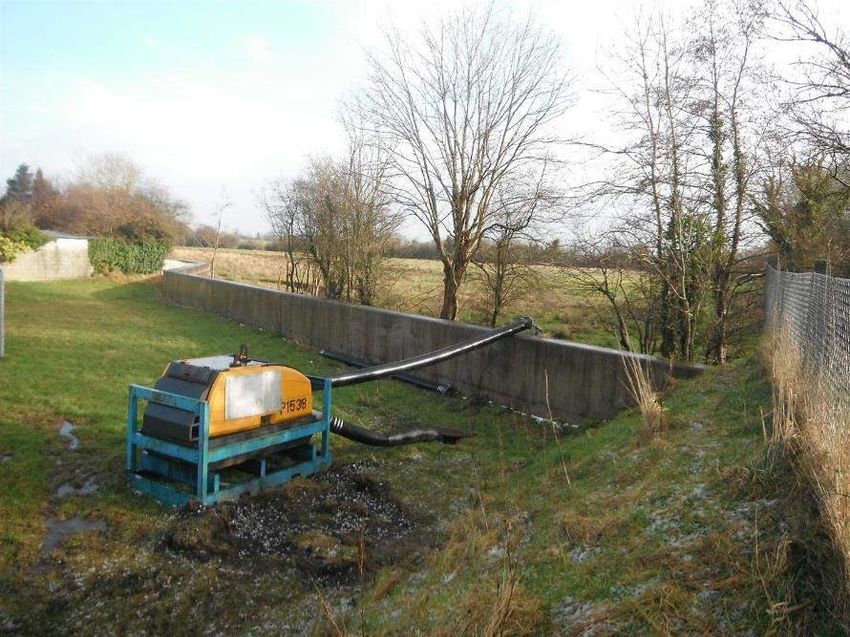
Galway County Council Ballinasloe Local Area Plan 2015-2021
Strategic Flood Risk Assessment
Contents
Page
1 Introduction and Context 3
2 Flood Risk Management Policy 4
2.1 European Policy 4
2.2 National Flood Policy 4
3 Principles of Flood Risk Assessment and Management 10
3.1 Definition of Flood Risk 10
3.2 Principles of Flood Risk Management 10
4 Stage 1 SFRA – Flood Risk Identification 13
4.1 Introduction 13
4.2 Site Description 13
4.3 Data Collection & Review 14
5 Stage 2 SFRA – Initial Flood Risk Assessment 18
5.1 Introduction 18
5.2 Site Walkovers and Ground-Truthing 18
5.3 Defence Assets and Structures 28
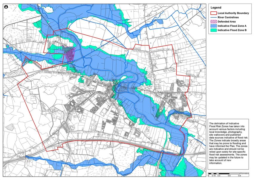
5.4 Indicative Flood Risk Zone Mapping 30
6 Recommendations 32
6.1 Introduction 32
6.2 Recommendations on Flood Risk Management Policy 32
6.3 Recommendations on Flood Risk Management Objectives 33
6.4 Recommendations on Land Use Zoning 36
6.5 Recommendations on Development Management
Guidelines 40
6.6 Requirement for Site-Specific Flood Risk Assessments in
potential flood risk areas outside of the Indicative Flood
Zones A and B 44
6.7 Recommendation for Future Review of Indicative Flood
Zones 46
Appendices
Appendix A
Summary of Relevant Provisions of the DEHLG/OPW Flood Guidelines for
Indicative Flood Zones A and B
4-04-03 | Issue 1 | 5 November 2015
J:\240000\240963-00\4. INTERNAL\4-04 REPORTS\4-04-03 INFRASTRUCTURE\SFRA\20151030_240963_BALLINASLOE_SFRA_V3.DOCX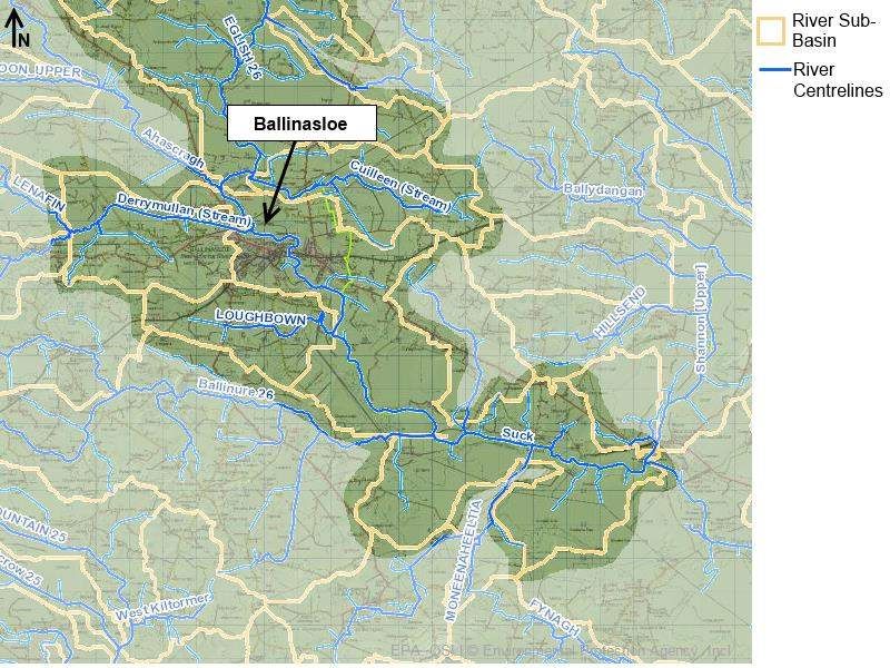
Galway County Council                                                                                               Ballinasloe Local Area Plan 2015-2021
                                                                                                                          Strategic Flood Risk Assessment

4-04-03 | Issue 1 | 5 November 2015
J:\240000\240963-00\4. INTERNAL\4-04 REPORTS\4-04-03 INFRASTRUCTURE\SFRA\20151030_240963_BALLINASLOE_SFRA_V3.DOCX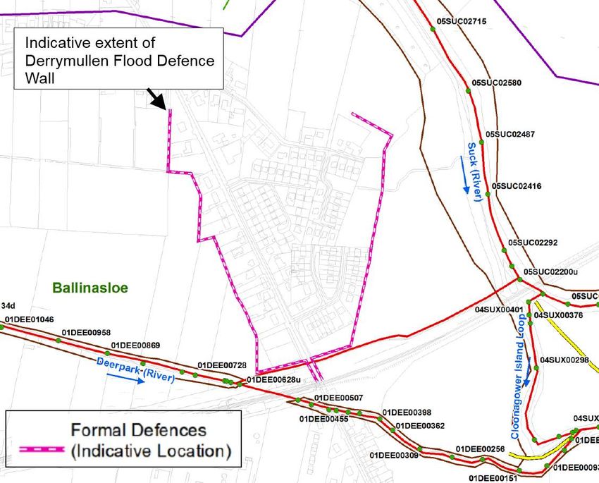
Galway County Council                                                                                               Ballinasloe Local Area Plan 2015-2021
                                                                                                                          Strategic Flood Risk Assessment

1                        Introduction and Context
Galway County Council has prepared a Local Area Plan (LAP) for Ballinasloe for
the period 2015-2021. The LAP has been prepared in accordance with the
requirements and provisions of the Planning and Development Act 2000 (as
amended) and sets out the overall strategy for the proper planning and sustainable
development of Ballinasloe for the period 2015-2021.
In accordance with Section 28 of the Planning and Development Act 2000 as
amended, the planning authority shall have regard to any guidelines issued by the
Minister of the Environment, Heritage and Local Government to planning
authorities in the performance of their functions including the preparation of
Development Plans.
Therefore, in accordance with “The Planning System and Flood Risk Management
- Guidelines for Planning Authorities” (Department of the Environment, Heritage
and Local Government and Office of Public Works, 2009) (The Guidelines), and
Circular PL 2/2014, (Department of the Environment, Community and Local
Government), a Strategic Flood Risk Assessment (SFRA) was required to be
undertaken during the development of the Plan.
Arup was appointed by Galway County Council to undertake a SFRA for the
Ballinasloe LAP in accordance with the Guidelines and Circular PL 2/2014. The
SFRA is an assessment of flood risk within Ballinasloe and includes mapped
boundaries for Indicative Flood Risk Zones, taking into account factors including
local knowledge, photography, site walkovers and various flood risk indicators.
The preparation of this SFRA was undertaken alongside the preparation of the Plan
from draft stage through to material alteration stage and adoption stage. The SFRA
has informed the Plan and enabled compliance with the Flood Risk Management
Guidelines. All material alterations (MA) have been assessed as part of the SFRA
and the adopted MA’s are reflected in this report.

4-04-03 | Issue 1 | 5 November 2015                                                                                                           Page 3
J:\240000\240963-00\4. INTERNAL\4-04 REPORTS\4-04-03 INFRASTRUCTURE\SFRA\20151030_240963_BALLINASLOE_SFRA_V3.DOCX
Galway County Council Ballinasloe Local Area Plan 2015-2021
Strategic Flood Risk Assessment
2 Flood Risk Management Policy
2.1 European Policy
The European Directive 2007/60/EC on the assessment and management of flood
risk aims to reduce and manage the risks that floods pose to human health, the
environment, cultural heritage and economic activity. The Directive applies to
inland waters as well as all coastal waters across the whole territory of the EU. The
Directive requires Member States to:
Carry out a preliminary assessment by December 2011 in order to identify
the river basins and associated coastal areas where potential significant
flood risk exists.
Prepare flood hazard and risk maps for the identified areas by December
2013 (it is estimated that these maps will be finalised in Ireland in 2015).
Prepare flood risk management plans focused on prevention, protection and
preparedness by December 2015. These plans are to include measures to
reduce the probability of flooding and its potential consequences.
Implementation of the EU Floods Directive is required to be coordinated with the
requirements of the EU Water Framework Directive and the current River Basin
Management Plans.
2.2 National Flood Policy
2.2.1 Report of the Flood Policy Review Group
Historically, flood risk management focused on land drainage for the benefit of
agricultural improvement. With increasing urbanisation, the Arterial Drainage Act,
1945, was amended in 1995 to permit the OPW to implement localised flood relief
schemes to provide flood protection for cities, towns and villages.
In line with changing national and international paradigms on how to manage flood
risk most effectively and efficiently, a review of national flood policy was
undertaken in 2003-2004. The review was undertaken by an Inter-Departmental
Review Group, led by the Minister of State at the Department of Finance with
special responsibility for the OPW. The Review Group prepared a report that was
put to Government, and subsequently approved and published in September 2004
(Report of the Flood Policy Review Group, OPW, 2004).
The scope of the review included a review of the roles and responsibilities of the
different bodies with responsibilities for managing flood risk, and to set a new
policy for flood risk management in Ireland into the future. The adopted policy was
accompanied by many specific recommendations, including:
Focus on managing flood risk, rather than relying only on flood protection
measures aimed at reducing flooding;
Taking a catchment-based approach to assess and manage risks within the
whole-catchment context;
4-04-03 | Issue 1 | 5 November 2015 Page 4
J:\240000\240963-00\4. INTERNAL\4-04 REPORTS\4-04-03 INFRASTRUCTURE\SFRA\20151030_240963_BALLINASLOE_SFRA_V3.DOCX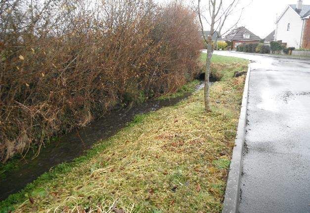
Galway County Council Ballinasloe Local Area Plan 2015-2021
Strategic Flood Risk Assessment
Being proactive in assessing and managing flood risks, including the
preparation of flood maps and flood risk management plans.
Develop and implement policy and guidelines on the consideration of flood
risk in planning and development control
The report confirmed the role of OPW as the lead agency for flood risk management
in Ireland. The coordination and implementation of Government policy on the
management of flood risk in Ireland is part of its responsibility. The European
Communities (Assessment and Management of Flood Risks) Regulations 2010 (S.I.
No. 122) identifies the Commissioners of Public Works as the ‘competent
authority’ with overall responsibility for implementation of the Floods Directive
2007/60/EC.
2.2.2 National CFRAM Programme
OPW in 2011 commenced the Irish national Catchment Flood Risk Assessment and
Management (CFRAM) programme. The CFRAM Programme is intended to
deliver on core components of the National Flood Policy, adopted in 2004, and on
the requirements of the EU Floods Directive. The Programme is being implemented
through CFRAM studies which are being undertaken for each of the six river basin
districts in Ireland. Ballinasloe is located in the area of the Shannon CFRAM Study.
The Programme comprises three phases as follows:
The Preliminary Flood Risk Assessment (PFRA) in 2011;
The CFRAM Studies and parallel activities, from 2011 to 2015; and
Implementation and Review from 2016 onwards.
The Programme provides for three main consultative stages as follows:
PFRAs in 2011;
Flood Hazard Mapping, in 2013 (it is estimated that these maps will be
finalised in 2015); and
Flood Risk Management Plans in 2015.
The PFRA identified areas at risk of significant flooding and includes maps
showing areas deemed to be at risk. Built-up areas deemed to be at significant risk,
where the flood risk that is of particular concern nationally, are identified as Areas
for Further Assessment (AFAs) and more detailed assessment of the extent and
degree of flood risk is currently being undertaken in these areas with the objective
of producing Flood Hazard Mapping. Ballinasloe was designated as an AFA.
The purpose of the CFRAM Studies is to assess and map existing and potential
future flood hazard and flood risk within the AFAs and to identify viable structural
and non-structural flood risk management measures for the AFAs and within each
river catchment as a whole (in catchment-based Flood Risk Management Plans).
The flood risk review carried out as part of the CFRAM Study confirmed the status
of Ballinasloe as an AFA.
It is important to note that at the time of preparation of this SFRA, the information
available from the Shannon CFRAM Study is incomplete and in draft format only.
The assessment and mapping of areas of flood risk, in particular, still awaits the
4-04-03 | Issue 1 | 5 November 2015 Page 5
J:\240000\240963-00\4. INTERNAL\4-04 REPORTS\4-04-03 INFRASTRUCTURE\SFRA\20151030_240963_BALLINASLOE_SFRA_V3.DOCX
Galway County Council Ballinasloe Local Area Plan 2015-2021
Strategic Flood Risk Assessment
finalisation of both Flood Hazard and Risk Maps for Areas for Further Assessment
(AFAs) (estimated for 2015) and for Flood Risk Management Plans (estimated for
2015).
The draft Shannon CFRAMS flood maps were supplied by Galway County Council
as part of the preparation of this SFRA. However, these maps remain subject to an
unknown amount of change before they can be robustly relied upon for decision-
making. Therefore it was deemed premature to rely solely on these maps to identify
the extents of flood risk areas in Ballinasloe.
2.2.3 Flood Risk Management Guidelines
2.2.3.1 Introduction
In 2009, the OPW and the then Department of the Environment and Local
Government (DEHLG) published Guidelines on flood risk management for
planning authorities entitled The Planning System and Flood Risk Management -
Guidelines for Planning Authorities. The Guidelines introduce mechanisms for the
incorporation of flood risk identification, assessment and management into the
planning process. Implementation of the Guidelines is intended to be achieved
through actions at the national, regional, local authority and site-specific levels.
Planning Authorities and An Bord Pleanála are required to have regard to the
Guidelines in carrying out their functions under the Planning Acts.
The core objectives of the Guidelines are to:
Avoid inappropriate development in areas at risk of flooding;
Avoid new developments which could increase flood risk elsewhere,
including that which may arise from surface water run-off;
Ensure effective management of residual risks for development permitted
in floodplains;
Avoid unnecessary restriction of national, regional or local economic and
social growth;
Improve the understanding of flood risk among relevant stakeholders; and
Ensure that the requirements of EU and national law in relation to the natural
environment and nature conservation are complied with at all stages of flood
risk management.
Notwithstanding the above, the flood risk management guidelines recognise that
there is a need to reconcile the desire to avoid development in areas at risk of
flooding while also ensuring sequential and compact urban development as several
large urban centres are already located in areas that are at risk of flooding. Section
3.7 of the guidelines state the following:
“Notwithstanding the need for future development to avoid areas at risk of flooding,
it is recognised that the existing urban structure of the country contains many well
established cities and urban centres, which will continue to be at risk of flooding.
At the same time such centres may also have been targeted for growth in the
National Spatial Strategy, regional planning guidelines and the various city and
county development plans taking account of historical patterns of development and
4-04-03 | Issue 1 | 5 November 2015 Page 6
J:\240000\240963-00\4. INTERNAL\4-04 REPORTS\4-04-03 INFRASTRUCTURE\SFRA\20151030_240963_BALLINASLOE_SFRA_V3.DOCXGalway County Council Ballinasloe Local Area Plan 2015-2021
Strategic Flood Risk Assessment
their national and strategic value. In addition, development plans have identified
various strategically located urban centres and particularly city and town centre
areas whose continued growth and development is being encouraged in order to
bring about compact and sustainable urban development and more balanced
regional development. Furthermore, development plan guidelines, issued by the
Minister for the Environment, Heritage and Local Government under Section 28 of
the Planning and Development Act 2000, have underlined the importance of
compact and sequential development of urban areas with a focus on town and city
centre locations for major retailing and higher residential densities.”
The above guidelines, inter alia, have been further clarified in Circular PL2/2014
as outlined in section 2.2.3.2.
2.2.3.2 Circular PL2/2014
Circular PL2/2014, published by the Department of Environment, Community and
Local Government in August 2014 clarified and amended certain aspects of the
Guidelines, which are of relevance to Local Authorities in the preparation of
development plans. The relevant amendments/clarifications are outlined below.
a. Section 3.7 Justification Test (Added text in bold italics)
…. In addition, development plans have identified various strategically located urban centres
and particularly city and town centre areas whose continued consolidation, growth,
development or regeneration, including for residential use, is being encouraged in order to
bring about compact and sustainable urban development, and more balanced regional
development…..
This item clarifies the principle of balancing flood risk management with the
development and regeneration of existing areas at flood risk within established
urban centres, even if such development is residential in nature.
b. Box 4, Justification Test for development plans, point 2 V) Foot note added (in bold italics)
2)The zoning or designation of the lands for the particular use or development type
is required to achieve the proper planning and sustainable development of the urban
settlement and, in particular:
v) There are no suitable alternative lands for the particular use or
development type, in areas at lower risk of flooding within or adjoining the
core of the urban settlement.
This criterion may be set aside where section 4.27b* Applies
c. Insertion of section 4.27a), that in summary says:
in areas categorised as “highly vulnerable development“ e.g. housing, to be zoned for
residential purposes and also located in flood zone A/B. in these areas where
housing/vulnerable use zoning has been considered as part of the development plan, subject
to justification text as appropriate, and existing use zoning is still appropriate, the
development plan must specify the nature of the and design of the structural or non-structural
flood risk management measures required prior to future development.
*This is assumed to be a typo and should instead refer to the new section 4.27a)
The above is an addition to the Justification Test for development plans, which sets
the procedure to be followed if highly vulnerable development in Flood Zone A or
B is considered appropriate by the Planning Authority. In this case the Planning
4-04-03 | Issue 1 | 5 November 2015 Page 7
J:\240000\240963-00\4. INTERNAL\4-04 REPORTS\4-04-03 INFRASTRUCTURE\SFRA\20151030_240963_BALLINASLOE_SFRA_V3.DOCXGalway County Council Ballinasloe Local Area Plan 2015-2021
Strategic Flood Risk Assessment
Authority is required to specify in the development plan their requirements for flood
risk management standards and measures in these areas. A specification of these
requirements is included in Section 6.4.3 of this report
The following text is also added to section 4.27
Regeneration areas
As indicated in section 3.7, development plans have identified various strategically located
urban centres and particularly city and town centre areas whose continued consolidation,
growth, and development or regeneration is being encouraged.
Where an existing residential area is proposed for residential regeneration, and is located in
a flood zone A/B, the planning authority should in the first instance consider the relocation
of the residential use and where in the opinion of the planning authority this is not feasible,
the development plan (or any variation) must specify the matters above, i.e. the nature and
design of structural or non-structural flood risk management measures required prior to
future development in such areas to ensure that flood hazard and risk to the area and other
locations will not be increased or, if practicable, will be reduced, with a particular emphasis
on the overall design of the area following the core principles set out in section 2.1 of
Appendix B on planning and design for flood risk.
Where more extensive regeneration is to take place, including site clearances, and where new
mixed development is proposed i.e. a docklands site, again the planning authority must
specify the nature and design of structural or non-structural flood risk management measures
required prior to future development in such areas to ensure that flood hazard and risk to the
area and other locations will not be increased or, if practicable, will be reduced, with a
particular emphasis on the overall design of the area to integrate flood risk management as a
central core of the design, ensuring that as far as possible vulnerable uses are not located in
flood zone A/B areas.
The above text outlines the guidelines for flood risk management in areas that have
been designated for urban regeneration by the Planning Authority.
d. Minor revision of section 5.28, Assessment of minor proposals in areas of flood risk
(Added text indicated thus)
5.28 Applications for minor development, such as small scale infill, small extensions to
houses or the rebuilding of houses, and most changes of use of existing buildings and or
extensions and additions to existing commercial and industrial enterprises, are unlikely to
raise significant flooding issues, unless they unless they obstruct important flow paths,
introduce a significant additional number of people into flood risk areas or entail the storage
of hazardous substances. Since such applications concern existing buildings or developed
areas, the sequential approach cannot be used to locate them in lower-risk areas and the
Justification Test will not apply. However, a commensurate assessment of the risks of
flooding should accompany such applications to demonstrate that they would not have
adverse impacts or impede access to a watercourse, floodplain or flood protection and
management facilities. These proposals should follow best practice in the management of
health and safety for users and residents of the proposal.
The above amendment changes the requirements for new small scale developments
in areas at flood risk. Small scale infill development will not now be required to
pass the Justification Test for development management.
4-04-03 | Issue 1 | 5 November 2015 Page 8
J:\240000\240963-00\4. INTERNAL\4-04 REPORTS\4-04-03 INFRASTRUCTURE\SFRA\20151030_240963_BALLINASLOE_SFRA_V3.DOCXGalway County Council Ballinasloe Local Area Plan 2015-2021
Strategic Flood Risk Assessment
4-04-03 | Issue 1 | 5 November 2015 Page 9
J:\240000\240963-00\4. INTERNAL\4-04 REPORTS\4-04-03 INFRASTRUCTURE\SFRA\20151030_240963_BALLINASLOE_SFRA_V3.DOCXGalway County Council Ballinasloe Local Area Plan 2015-2021
Strategic Flood Risk Assessment
3 Principles of Flood Risk Assessment and
Management
3.1 Definition of Flood Risk
Flooding is an environmental phenomenon and can pose a risk to human health as
well as causing economic and social effects, including damage to property, damage
to health and wellbeing etc. Flood risk is an expression of the combination of the
flood probability or likelihood and the magnitude of the potential consequences of
the flood event. It is normally expressed in terms of the following relationship:
Flood risk = Likelihood of flooding x Consequences of flooding
Likelihood of flooding is normally defined as the percentage probability of a flood
of a given magnitude or severity occurring or being exceeded in any given year. For
example, a 1% Annual Exceedance Probability (AEP) indicates the severity of a
flood that is expected to be exceeded on average once in 100 years, i.e. it has a 1 in
100 (1%) chance of occurring in any one year.
Consequences of flooding depend on the hazards associated with the flooding (e.g.
depth of water, speed of flow, rate of onset, duration, wave-action effects, water
quality), and the vulnerability of people, property and the environment potentially
affected by a flood (e.g. the age profile of the population, the type of development,
presence and reliability of mitigation measures etc.).
3.2 Principles of Flood Risk Management
The key principles of flood risk management set out in the flood guidelines are to:
Avoid development that will be at risk of flooding or that will increase the
flooding risk elsewhere, where possible;
Substitute less vulnerable uses, where avoidance is not possible; and
Mitigate and manage the risk, where avoidance and substitution are not
possible.
The Guidelines follow the principle that development should not be permitted in
flood risk areas, particularly floodplains, except where there are no alternative and
appropriate sites available in lower risk areas that are consistent with the objectives
of proper planning and sustainable development.
Development in areas which have the highest flood risk should be avoided and/or
only considered in exceptional circumstances (through a prescribed Justification
Test) if adequate land or sites are not available in areas which have lower flood risk.
Most types of development would be considered inappropriate in areas which have
the highest flood risk. Only water-compatible development such as docks and
marinas, dockside activities that require a waterside location, amenity open space,
outdoor sports and recreation and essential transport infrastructure that cannot be
located elsewhere would be considered appropriate in these areas.
4-04-03 | Issue 1 | 5 November 2015 Page 10
J:\240000\240963-00\4. INTERNAL\4-04 REPORTS\4-04-03 INFRASTRUCTURE\SFRA\20151030_240963_BALLINASLOE_SFRA_V3.DOCXGalway County Council Ballinasloe Local Area Plan 2015-2021
Strategic Flood Risk Assessment
3.2.1 Definition of Flood Zones
Flood zones in the Guidelines are geographical areas within which the likelihood
of flooding is in a particular range and they are a key tool in flood risk management
within the planning process as well as in flood warning and emergency planning.
There are three types or levels of flood zones defined in the Guidelines as shown in
Table 1
Table 1 Flood Zone Designations
Flood Zone Probability of Flood Event
Designation
Probability of flooding from rivers and the sea is highest
Flood Zone A (greater than 1% or 1 in 100 for river flooding or 0.5% or 1
in 200 for coastal flooding).
Probability of flooding from rivers and the sea is moderate
Flood Zone B (between 0.1% or 1 in 1000 year and 1% or 1 in 100 for river
flooding and between 0.1% or 1 in 1000 year and 0.5% or 1
in 200 for coastal flooding); and
Probability of flooding from rivers and the sea is low (less
than 0.1% or 1 in 1000 for both river and coastal flooding).
Flood Zone C
Flood Zone C covers all areas of the plan which are not in
zones A or B.
3.2.2 Definition of Vulnerability Classes
The following table summarises the Vulnerability Classes defined in the Guidelines
and provides a sample of the most common type of development applicable to each.
Table 2 Definition of Vulnerability Classification
Vulnerability Development Type
Classification
Highly Vulnerable Includes Garda, ambulance and fire stations, hospitals,
Development schools, residential dwellings, residential institutions,
essential infrastructure, such as primary transport and
utilities distribution and SEVESO and IPPC sites, etc.
Less Vulnerable Includes retail, leisure, warehousing, commercial,
Development industrial and non-residential institutions, etc.
Water Compatible Includes Flood Control Infrastructure, docks, marinas,
Development wharves, navigation facilities, water based recreation
facilities, amenity open spaces and outdoor sport and
recreation facilities
4-04-03 | Issue 1 | 5 November 2015 Page 11
J:\240000\240963-00\4. INTERNAL\4-04 REPORTS\4-04-03 INFRASTRUCTURE\SFRA\20151030_240963_BALLINASLOE_SFRA_V3.DOCXGalway County Council Ballinasloe Local Area Plan 2015-2021
Strategic Flood Risk Assessment
3.2.3 Types of Vulnerability Class appropriate to each Zone
The following table illustrates the different types of Vulnerability Class appropriate
to each Zone and indicates where a Justification Test will be required.
Table 3 Applicability of Justification Test
Flood Zone A Flood Zone B Flood Zone C
Highly Justification Test Justification Test Appropriate
Vulnerable
Less Vulnerable Justification Test Appropriate Appropriate
Water Appropriate Appropriate Appropriate
Compatible
3.2.3.1 Stages of SFRA
The Flood Risk Management Guidelines recommend a staged approach to flood
risk assessment that covers both the likelihood of flooding and the potential
consequences. The stages of appraisal and assessment are:
Stage 1 Flood risk identification – to identify whether there may be any
flooding or surface water management issues related to either the area of
regional planning guidelines, development plans and LAP’s or a proposed
development site that may warrant further investigation at the appropriate
lower level plan or planning application levels;
Stage 2 Initial flood risk assessment – to confirm sources of flooding that
may affect a plan area or proposed development site, to appraise the
adequacy of existing information and to scope the extent of the risk of
flooding which may involve preparing indicative flood zone maps. Where
hydraulic models exist the potential impact of a development on flooding
elsewhere and of the scope of possible mitigation measures can be assessed.
In addition, the requirements of the detailed assessment should be scoped;
and
Stage 3 Detailed flood risk assessment – to assess flood risk issues in
sufficient detail and to provide a quantitative appraisal of potential flood
risk to a proposed or existing development or land to be zoned, of its
potential impact on flood risk elsewhere and of the effectiveness of any
proposed mitigation measures.
4-04-03 | Issue 1 | 5 November 2015 Page 12
J:\240000\240963-00\4. INTERNAL\4-04 REPORTS\4-04-03 INFRASTRUCTURE\SFRA\20151030_240963_BALLINASLOE_SFRA_V3.DOCXGalway County Council Ballinasloe Local Area Plan 2015-2021
Strategic Flood Risk Assessment
4 Stage 1 SFRA – Flood Risk Identification
4.1 Introduction
A Stage 1 SFRA (flood risk identification) was undertaken in order to identify
whether there may be any flooding or surface water management issues within the
town and consequently whether a Stage 2 SFRA (initial flood risk assessment)
should be undertaken. The Stage 1 SFRA was based on existing information on
flood risk indicators and involved consulting a range of sources as detailed in
Section 4.3 below. The information provided in this section clearly identifies a
potential flood risk issue within the Ballinasloe Plan area and therefore it was
deemed appropriate to proceed with a Stage 2 SFRA.
4.2 Site Description
Ballinasloe is located on the banks of the Suck River in County Galway. The
catchment area upstream of Ballinasloe is approximately 1350km2. The confluence
of the River Deerpark with the Suck River is located at the western end of the town,
in the vicinity of Derrymullen. (The River Deerpark is called Derrymullan Stream
on EPA mapping).
The River Suck regularly floods a large and well-defined floodplain in Ballinasloe.
Regular flooding may typically be caused by high fluvial flows on the Suck, or due
to a backwater effect during times of flood on the River Shannon, (located 13km
downstream of the town), or potentially a combination of both.
The existing watercourse network and river subbasins in Ballinasloe are shown in
Figure 1 below.
Figure 1 River Sub-Basin, Rivers and Streams (Source: Environmental Protection Agency)
4-04-03 | Issue 1 | 5 November 2015 Page 13
J:\240000\240963-00\4. INTERNAL\4-04 REPORTS\4-04-03 INFRASTRUCTURE\SFRA\20151030_240963_BALLINASLOE_SFRA_V3.DOCXGalway County Council Ballinasloe Local Area Plan 2015-2021
Strategic Flood Risk Assessment
4.3 Data Collection & Review
A data collection exercise was initially carried out in order to collate data on flood
risk indicators in the study area.
Indicators of flood risk based on historical flooding events are identified and
described in Table 4 below.
Indicators of flood risk based on computational models and/or predictive mapping are
identified and described in Table 5 below.
The following relevant reports and documents were also collated and reviewed:
Ballinasloe Local Area Plan 2009-2015, including background reports
Galway County Development Plan 2015-2021
Ballinasloe Flood Relief Study (Hydro Environmental Ltd., 2010)
Ballinasloe Flood Protection Report (Galway County Council, November
2010)
Pre-Draft Submissions on the Draft Ballinasloe Local Area Plan 2015-2021
Existing reference SFRA’s in County Galway, supplied by Galway County
Council
4-04-03 | Issue 1 | 5 November 2015 Page 14
J:\240000\240963-00\4. INTERNAL\4-04 REPORTS\4-04-03 INFRASTRUCTURE\SFRA\20151030_240963_BALLINASLOE_SFRA_V3.DOCXGalway County Council Ballinasloe Local Area Plan 2015-2021
Strategic Flood Risk Assessment
Table 4 Historical Flood Risk Indicator Mapping
Information Description Spatial Spread Strategic Limitations
Source
Benefitting lands Benefitting lands mapping is a dataset identifying land that might benefit No benefitting lands in the current Plan area Identifies broad areas – low resolution for flood risk
(OPW) from the implementation of Arterial (Major) Drainage Schemes (under management
the Arterial Drainage Act 1945) and indicating areas of land estimated
or reported to be subject to flooding or poor drainage.
Drainage Districts This drainage scheme mapping dataset was prepared on behalf of the Drainage Districts in Ballinasloe are Identifies large broad areas - very low resolution for
(OPW) Drainage Districts (Local Authorities with statutory responsibility for identified along the River Suck reaching from flood risk management
maintenance under the Arterial Drainage Act, 1925). These maps the northwestern to the southeastern extent of
identify land that might benefit from the implementation of Arterial the current Plan area.
(Major) Drainage Schemes and indicate areas of land subject to flooding
or poor drainage.
Alluvium Soils Mineral alluvial soil mapping is indicative of recurrent or significant Alluvium soils have been identified along the Drainage may have changed significantly since these
fluvial flooding at some point in the past and was generated by Teagasc Suck River and flood plain corridor. There is soils were deposited.
with co-operation of the Forest Service, EPA and GSI. This project was also an area of alluvium soil located east of
completed May 2006. the R357 and north of the R446 on a minor
tributary stream
Road Closures & This dataset has been prepared by Galway County Council’s Roads There are two recorded road closures during Potential errors in evidence and approximated closed
Lengths November Department and identifies the road closures and major roads closed the 2009 Flood Event within the Ballinasloe roads lengths
2009 during the November 2009 event. The road lengths (lines) which have Local Area boundary which are the R446
been drawn are approximate and are compiled entirely of eye witness, (Church Street and Bridge Street) and on the
anecdotal evidence mainly noted over the phone from area staff and R358 road north of Deerpark
members of the public i.e. no surveying was involved.
Photographs The OPW provided aerial photography capturing lands within and Aerial photography included view of Coverage limited to certain areas
outside of the Plan area during the 2009 flood. Ballinasloe town centre, Derrymullan and the
Northwest of Ballinasloe and the Willow
Park Area.
Flood Events and A flood event is the occurrence of recorded flooding at a given Flood event in 2009 and 1995 were recorded This dataset only provides a spot location and
Flood Extents from location on a given date. The flood event is derived from different within the Plan area does not list flood events which have not been
the OPW types of information (reports, photographs etc.). A flood event recorded as part of the dataset.
floodmaps.ie that has occurred more than once at a certain area is named a
website recurring flood event. A flood extent is an inundated area as
recorded at a certain moment in time.
4-04-03 | Issue 1 | 5 November 2015 Page 15
J:\240000\240963-00\4. INTERNAL\4-04 REPORTS\4-04-03 INFRASTRUCTURE\SFRA\20151030_240963_BALLINASLOE_SFRA_V3.DOCXGalway County Council Ballinasloe Local Area Plan 2015-2021
Strategic Flood Risk Assessment
Information Description Spatial Spread Strategic Limitations
Source
‘Liable to flood’ The Ordnance Survey of Ireland (OSI) 6” mapping identifies Area "Liable to Flood" were identified on The OSI maps simply show the text Liable to
markings on the broad areas as being Liable to Floods. both banks of the Suck River through its Floods without delineating the extent of these
historic OSI ‘6 entire reach through the Plan Area areas. For the purposes of these draft maps a GIS
Inch’ maps system has been used to indicate the likely
potential extent of these areas.
As these maps were based on survey work
carried out from 1833-1844 with many updated
in the 1930s and 40s, they do not show or take
any account of recent changes including changes
in surface drainage, such as development in
floodplains, road realignments or drainage
works for forestry or agriculture. So there is
significant potential that flood risk in some areas
may have increased or reduced since they were
prepared.
4-04-03 | Issue 1 | 5 November 2015 Page 16
J:\240000\240963-00\4. INTERNAL\4-04 REPORTS\4-04-03 INFRASTRUCTURE\SFRA\20151030_240963_BALLINASLOE_SFRA_V3.DOCXGalway County Council Ballinasloe Local Area Plan 2015-2021
Strategic Flood Risk Assessment
Table 5 Modelled Flood Risk Indicator Mapping
Information Source Description Spatial Spread Strategic Limitations
OPW Preliminary Flood The OPW PFRA mapping dataset has been arrived at by: PFRA Fluvial flood extents The PFRA is only a preliminary assessment, based
Risk Assessment (PFRA) Reviewing records of floods that have happened in the includes land adjacent to the Suck on available or readily derivable information.
Fluvial, Groundwater and past; River and its tributaries as they Analysis has been undertaken to identify areas prone
Pluvial flood maps flow through the current Plan
Undertaking analysis to determine which areas might flood to flooding, and the risks associated with such
Area. flooding, but this analysis is purely indicative and
in the future, and what the impacts might be; and
undertaken for the purpose of completing the draft
Extensive consultation with each local authorities and
PFRA Groundwater flood extents PFRA. The mapping has been developed using
other Government departments and agencies.
includes pockets of flooding in the simple and cost-effective methods and is based on
This assessment has considered all types of flooding, including broadscale simple analysis and may not be accurate
west of the Plan area, next to the
that which can occur from rivers, the sea and estuaries (not for a specific location/use.
quarry, the Famine Memorial
relevant for Ballinasloe), heavy rain, groundwater, the failure
Garden and Brackernagh Area.
of infrastructure, and so on. It has also considered the impacts
flooding can have on people, property, businesses, the
environment and cultural assets. Further information on the PFRA Pluvial flood extents is
purpose and development of the OPW PFRA Maps are found at a number of locations
available on www.cfram.ie. throughout the Plan Area.
Emerging data from the The Shannon CFRAM Flood Risk Review was undertaken to The CFRAM Study Flood Risk CFRAMS mapping only considers fluvial and tidal
Shannon CFRAM Study help validate the findings of the PFRA, informing decisions on Review covers Ballinasloe town, flood risk.
which sites will be taken forward as Areas for Further and the Draft mapping covers the
Assessment (AFAs) for a more detailed assessment within the extent of the Plan Area.
CFRAM Programmes. The Flood Risk Review recommended
“AFA Status” for the settlement of Ballinasloe
The draft Shannon CFRAMS flood extents maps also assist in
estimating the extent of flood zones A and B
4-04-03 | Issue 1 | 5 November 2015 Page 17
J:\240000\240963-00\4. INTERNAL\4-04 REPORTS\4-04-03 INFRASTRUCTURE\SFRA\20151030_240963_BALLINASLOE_SFRA_V3.DOCXGalway County Council Ballinasloe Local Area Plan 2015-2021
Strategic Flood Risk Assessment
5 Stage 2 SFRA – Initial Flood Risk
Assessment
5.1 Introduction
A Stage 2 SFRA (initial flood risk assessment) was undertaken to:
Confirm the sources of flooding that may affect areas within the Plan
boundary;
Appraise the adequacy of existing information as identified in the Stage 1
SFRA
Scope the extent of the risk of flooding through the preparation of indicative
flood zone maps.
5.2 Site Walkovers and Ground-Truthing
As part of the Stage 2 SFRA, a site walkover and ground-truthing exercise was
carried out. This involved inspecting the study area on foot in order to assess and
appraise the validity of existing flood risk information.
The site walkover was carried out on Monday 23 February 2015. The site walkover
focused on areas considered at risk from fluvial, pluvial and groundwater flooding.
These locations consisted of, but are not limited to, areas close to the River Suck
and its tributaries, local watercourses, flood defence structures and topographic
areas and features that correspond with flood extent boundaries.
A key plan of the ground-truthing locations is shown in Figure 2.
Table 6 details the findings of the ground-truthing at specific locations.
4-04-03 | Issue 1 | 5 November 2015 Page 18
J:\240000\240963-00\4. INTERNAL\4-04 REPORTS\4-04-03 INFRASTRUCTURE\SFRA\20151030_240963_BALLINASLOE_SFRA_V3.DOCXGalway County Council Ballinasloe Local Area Plan 2015-2021
Strategic Flood Risk Assessment
Figure 2 Ground-truthing locations key plan
4-04-03 | Issue 1 | 5 November 2015 Page 19
J:\240000\240963-00\4. INTERNAL\4-04 REPORTS\4-04-03 INFRASTRUCTURE\SFRA\20151030_240963_BALLINASLOE_SFRA_V3.DOCXGalway County Council Ballinasloe Local Area Plan 2015-2021
Strategic Flood Risk Assessment
Table 6 Ground-Truthing Findings and Recommendations at Specific Locations
Location Location Local Knowledge Flood Risk Indicators including Photography Ground Truthing Findings
No. Description
1 Ballinasloe Flooding of water Stage 1 SFRA for the Galway County Development plan The topography around the water treatment plant is flat and low
Water Treatment treatment plant 2015-2021 identifies flood risk within this area and the lying. The water treatment plant appears to be located within the
Plant – Located during 2009 need to construct a flood defence around the treatment floodplain. A number of properties located in close proximity to the
to the north of November flood plant. water treatment works are likely to be at risk from a 1 in 100 year
Ballinasloe at event. flood event.
Upper The flood extent boundary within this area appears reasonable and
Derrymullen on is confirmed by flat topography, few obstructions to flood flow
the R339. paths and flood extent mapping.
2 Derrymullen/Wil Low lying Stage 1 SFRA for the Galway County Development plan The River Suck floodplain is located in close proximity to the
low Park – to properties (mainly 2015-2021 identifies flood risk within this area. Flood properties. A small water course also runs parallel and adjacent to
north of residential) in the defences in the form of steel sheet piled walls and flood the rail line. A permanent large pump was noted to be located in
Ballinasloe Rail Willow Park embankments have been constructed to protect open ground on the ‘dry’ side of the flood defence. In addition,
Station. flooded during properties along Willow Drive. saturated ground on the ‘dry’ side of the defence suggests that
November 2009 The aerial photo displays Derrymullen during the 2009 surface water flooding may remain an issue.
flood event. flood event. The topography is low lying and is likely to be defended from
flooding of the River Suck. The site walkover and ground-truthing
exercise appears to confirm that the relatively recently constructed
flood defences now defend this area.
4-04-03 | Issue 1 | 5 November 2015 Page 20
J:\240000\240963-00\4. INTERNAL\4-04 REPORTS\4-04-03 INFRASTRUCTURE\SFRA\20151030_240963_BALLINASLOE_SFRA_V3.DOCXGalway County Council Ballinasloe Local Area Plan 2015-2021
Strategic Flood Risk Assessment
Location Location Local Knowledge Flood Risk Indicators including Photography Ground Truthing Findings
No. Description
3 Sarsfield Road – Wide scale Stage 1 SFRA for the Galway County Development plan Deer Park river, a tributary of the River Suck, flows in close
south of flooding occurred 2015-2021 identifies flooding risk within this area. proximity to a number of residential properties on Sarsfield Road.
Ballinasloe Rail during 2009 event. Aerial photograph displays flooded area along Sarsfield Low point in Sarsfield Road immediately south of the rail crossing.
Station Road during the 2009 flood events. Channel appears shallow and heavily vegetated.
Ground levels fall from the rail embankment in a southerly direction
which suggests that ponding of flood waters is likely to occur. The
flooding extents would appear to be in agreement with the findings
of the ground-truthing.
4 Famine - Stage 1 SFRA for the Galway County Development plan Localised low point in ground and road levels adjacent to the
Remembrance 2015-2021 identifies flood risk within this area. Famine Remembrance Park on the R348. The SFRA maps suggest
Park – Located to that the area is at risk from pluvial flooding. It is likely that surface
the west of water flooding may occur within this area due to the local
Ballinasloe Town topography and flow paths from high ground to the south of the
Centre on the Famine Remembrance Park.
R348. Flood extent maps appear to confirm the likelihood of pluvial
flooding to properties and the R348 road at this area. However, it
was not apparent from the site walkover whether flow paths from
the Deer Park River could reach this site, and thus cause fluvial
flooding.
5 Society St. – Low - Stage 1 SFRA for the Galway County Development plan Moderate change in gradient from Sarsfield Road to Society Street.
area adjacent to 2015-2021 identifies flood risk within this area. A local high point in the topography is located from the junction of
the Presbyterian Church Hill to Society Street. Likely that flow paths may result in
Church pluvial flooding in this area during a flood event.
Flood extent maps and ground-truthing would appear to confirm the
likelihood of flood risk to commercial properties and the R348 road
at this area.
4-04-03 | Issue 1 | 5 November 2015 Page 21
J:\240000\240963-00\4. INTERNAL\4-04 REPORTS\4-04-03 INFRASTRUCTURE\SFRA\20151030_240963_BALLINASLOE_SFRA_V3.DOCXGalway County Council Ballinasloe Local Area Plan 2015-2021
Strategic Flood Risk Assessment
Location Location Local Knowledge Flood Risk Indicators including Photography Ground Truthing Findings
No. Description
6 River View – - Stage 1 SFRA for the Galway County Development plan Appears that commercial property is located within the flood plain.
Located to the 2015-2021 identifies flood risk within this area. The The surrounding topography is flat and low lying. Agricultural land
north of the town photo below was taken from River View road with the surrounds the commercial properties.
centre at Topline river in normal flow conditions and displays the flood Local vegetation consistent with saturated ground was noted to be
Hardware Store. plain adjacent to Topline Hardware Store. growing in close proximity to the commercial property.
Flood extent maps and ground-truthing would appear to confirm the
likelihood of fluvial flood risk to commercial property.
7 St. Michael’s Wide scale The town park risk, according to previous hydraulic A tributary of the River Suck flows in a northerly direction
Park – Town flooding of the studies, is subject to high risk of flooding (1 in 10 year underneath Bridge Street Bridge. The water course splits
Park located town park during event). The photo below displays flooding during the immediately upstream of Bridge Street Bridge into three channels
south of Bridge November 2009 November 2009 event. before merging again a short distance downstream of the bridge. A
Street and surrounding number of constrictions and a lack of capacity within the shallow
areas. channel would indicate issues with conveyance during flood events.
Flood extent maps and ground-truthing appear to confirm the
likelihood of flooding to commercial and residential property.
Previous flood events have been well documented within this area.
4-04-03 | Issue 1 | 5 November 2015 Page 22
J:\240000\240963-00\4. INTERNAL\4-04 REPORTS\4-04-03 INFRASTRUCTURE\SFRA\20151030_240963_BALLINASLOE_SFRA_V3.DOCXGalway County Council Ballinasloe Local Area Plan 2015-2021
Strategic Flood Risk Assessment
Location Location Local Knowledge Flood Risk Indicators including Photography Ground Truthing Findings
No. Description
8 Ballinasloe Wide scale Stage 1 SFRA for the Galway County Development plan The R446 road is at a higher level than the surrounding ground at
Harbour – flooding of 2015-2021 identifies flood risk within this area. The Ballinasloe Harbour.
Located adjacent Ballinasloe photo below displays flooding during the November The surrounding topography is relatively flat. The harbour areas has
to R446 road in Harbour during 2009 event. a history of flooding. Low lying areas to the south of the harbour
the town centre. November 2009 appear to be saturated and liable to flooding.
and surrounding
Flood extent maps, ground-truthing appear to confirm the likelihood
areas.
of flooding to commercial property. Local vegetation consistent
with saturated ground was noted to be growing in close proximity
to the commercial property.
9 Hopsons Lane – Surface water Stage 1 SFRA for the Galway County Development plan Previous flooding likely to have been caused by a combination of
West of the town flooding of 2015-2021 identifies flood risk within this area. under-capacity drainage systems and fluvial flooding. While new
park Hopsons Lane The photo below displays the channel in the town park drainage works constructed after the 2009 flood events are not
during November in normal flow conditions. The apparent unflapped largely visible, it appeared from the site walkover that a drainage
2009 flood event. outfall can be seen in the central middle ground of the outfall into the watercourse at the town park is unflapped. A number
photo. of commercial and residential properties are located in close
proximity to the watercourse.
Flood extent maps and ground-truthing appear to confirm the
likelihood of flood risk to commercial and residential property.
4-04-03 | Issue 1 | 5 November 2015 Page 23
J:\240000\240963-00\4. INTERNAL\4-04 REPORTS\4-04-03 INFRASTRUCTURE\SFRA\20151030_240963_BALLINASLOE_SFRA_V3.DOCXGalway County Council Ballinasloe Local Area Plan 2015-2021
Strategic Flood Risk Assessment
Location Location Local Knowledge Flood Risk Indicators including Photography Ground Truthing Findings
No. Description
10 Shearwater Hotel Previously closed Stage 1 SFRA for the Galway County Development plan While it is not known if flooding has previously occurred at the
– Located during the 2009 2015-2021 identifies flood risk within this area. hotel, it is known that the 2009 flood events have caused disruption
adjacent to the flood event as a The photo below displays the top of the embankment to business due to temporary closure of the hotel.
R446 precautionary that surrounds the Shearwater Hotel site and was taken A large embankment surrounds the hotel perimeter. SFRA flood
measures. No during normal flow conditions. maps appear to show small extents of flooding within the hotel
record of flooding grounds and this may be due to backing up of surface water drains
of the hotel. or surface water flooding.
Flood extent maps appear to confirm the likelihood of small extents
of flooding to the hotel grounds. This may be as a result of pluvial
flooding. However, a site walkover has concluded that it is likely
that the embankment provides protection from fluvial flooding.
11 Retirement - Stage 1 SFRA for the Galway County Development plan Likely that conveyance constrictions caused by the bridge arches on
Village/Bridge 2015-2021 identifies flood risk within this area. Bridge St. may lead to elevated water levels and localised flooding
Street – The The photo below displays the watercourse in normal of the retirement village.
Millrace flow conditions. The photo displays the close proximity The topography of the surrounding land to the north west of the
retirement village of the retirement village to the watercourse. retirement village rises relatively steeply which is in line with the
is located to the SFRA flood extent maps.
north of the town
Flood extent maps and ground-truthing appears to confirm the
park
likelihood of flooding to commercial and residential property.
4-04-03 | Issue 1 | 5 November 2015 Page 24
J:\240000\240963-00\4. INTERNAL\4-04 REPORTS\4-04-03 INFRASTRUCTURE\SFRA\20151030_240963_BALLINASLOE_SFRA_V3.DOCXGalway County Council Ballinasloe Local Area Plan 2015-2021
Strategic Flood Risk Assessment
Location Location Local Knowledge Flood Risk Indicators including Photography Ground Truthing Findings
No. Description
12 Ballinasloe East Sluice structures on Stage 1 SFRA for the Galway County Development plan Removal of the sluice gates on the upstream face of the bridge is
Bridge – Large the bridge have 2015-2021 identifies flood risk within this area. likely to have improved conveyance through the bridge.
stone arch bridge been attributed to The photo below displays the downstream face of the Immediately upstream of the bridge, the surrounding land is very
that spans the causing bridge in normal flow conditions. flat and agricultural land forms the floodplain. A number of
River Suck to the conveyance issues commercial and residential properties are located in close proximity
east of the town and afflux of flood to the bridge.
centre. waters at the site To the east of the site, a recently constructed reinforced concrete
during the 2009 retaining wall at Atlas Industries retains higher ground. Channel
November flood clearance of vegetation and detritus to improve conveyance after the
events. 2009 floods was also recommended by Galway County Council. A
fall in gradient in the road, approximately 100-150m east of the
bridge, was noted during the site walkover.
Flood extent maps and ground-truthing appear to confirm the
likelihood of flooding to commercial and residential property.
13 Roscarn – - A small watercourse flows to the north of Roscarn High ground to the east of the housing estate may facilitate flood
Housing estate housing estate. Pluvial flood extent maps indicate that flow paths entering the housing estate. From a visual assessment on
located to the east the housing estate may be at risk from flooding. site, surface water drains appeared to be blocked which may lead to
of the town on The photo below indicates a low point in the topography increased risk of surface water flooding. The surrounding land is
Church Street of the housing estate which may be liable to ponding of largely agricultural.
(R446). flood water. Flood extent maps and ground-truthing appear to confirm the
likelihood of flooding to residential property.
4-04-03 | Issue 1 | 5 November 2015 Page 25
J:\240000\240963-00\4. INTERNAL\4-04 REPORTS\4-04-03 INFRASTRUCTURE\SFRA\20151030_240963_BALLINASLOE_SFRA_V3.DOCXGalway County Council Ballinasloe Local Area Plan 2015-2021
Strategic Flood Risk Assessment
Location Location Local Knowledge Flood Risk Indicators including Photography Ground Truthing Findings
No. Description
14 Glentaun Road – - A small watercourse flows through the Glentaun estate. Flood water may gather in localised low areas of ground leading to
Housing estate PFRA maps indicate that the housing estate may be at flooding of the Glentaun housing estate.
located to the east risk from flooding Flood extent maps and ground-truthing appear to confirm the
of the town off likelihood of flooding to residential property.
Church Street
(R446).
15 Moycarn - Lodge - Stage 1 SFRA for the Galway County Development plan Topography of the surrounding land generally slopes from a north
and Marina 2015-2021 identifies flood risk within this area. to south direction towards Moycarn Lodge and Marina.
The photo below displays the culverted watercourse A water course to the west of the Lodge flows in parallel to Moycarn
flowing into the open channel section along Moycarn Drive and appears to be shallow in nature. The watercourse is
Drive during normal flow conditions. culverted for a considerable length along Moycarn Drive. This may
lead to capacity and conveyance issues during flood events and may
result in increasing flood risk to the surrounding residential and
commercial properties.
Flood extent maps and ground-truthing appear to confirm the
likelihood of flooding to residential property.
16 The - Stage 1 SFRA for the Galway County Development plan Topography of the surrounding land generally slopes significantly
Pines/Riverside – 2015-2021 identifies flood risk within this area. from a north to south direction from Church Street to Greenhills
Located to the View and Riverside View.
east of A wastewater treatment plant appears to be within the flood extents
Ballinasloe off which may increase risk of pollution to surrounding properties
the R357 road. during a flood event.
Flood extent maps and ground-truthing appear to confirm the
likelihood of flooding to residential property.
4-04-03 | Issue 1 | 5 November 2015 Page 26
J:\240000\240963-00\4. INTERNAL\4-04 REPORTS\4-04-03 INFRASTRUCTURE\SFRA\20151030_240963_BALLINASLOE_SFRA_V3.DOCXYou can also read