Telegraph Hill conservation area - character appraisal
←
→
Page content transcription
If your browser does not render page correctly, please read the page content below
Telegraph Hill
conservation area
character appraisal
d Telegraph Hill conservation area character appraisal
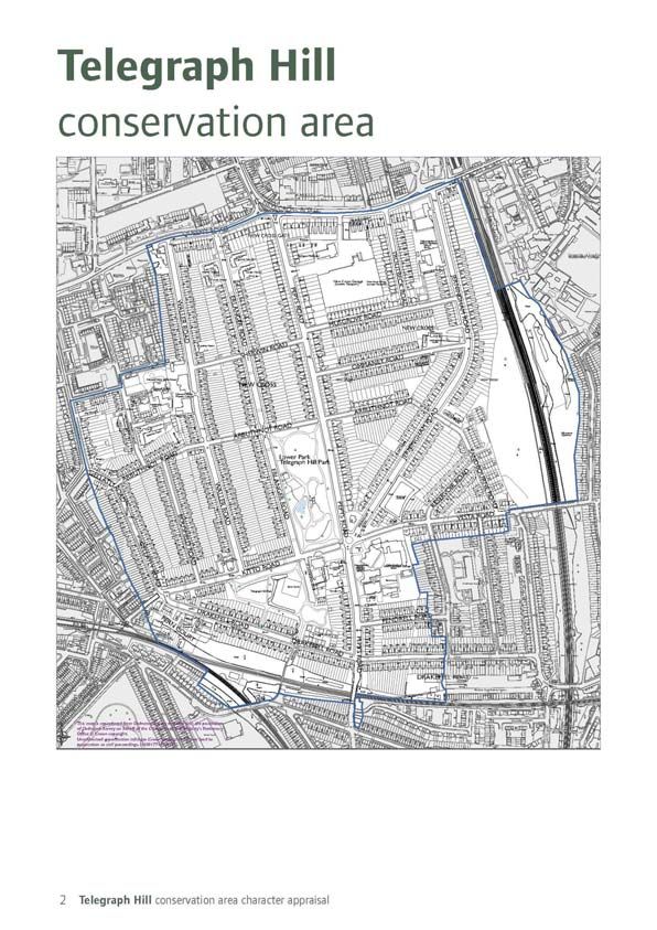
Telegraph Hill conservation area
Summary of Special Interest
The Telegraph Hill Conservation Area has a hillside location on the slopes of Telegraph Hill. The
conservation area encloses a well preserved planned development of late 19th century terraces
and pairs of houses built under the control of the Worshipful Company of Haberdashers. The
Haberdashers’ Company’s development of a full community also includes church, schools and
public park, all of which remain in their original use.

The area’s uniform and cohesive architectural character is based around two main house types
(two- and three-storey) built to standardised designs within approximately 30 years between
1870-1900.

The houses are good examples of late 19th century middle class houses and villas with many
surviving design features such as vertical sliding sash timber windows, robust part-glazed
front doors, two-storey canted bays, recessed front doors, pitched slate roofs and decorative
brickwork. Numerous original architectural details survive such as glazed decorative porch tiles,
foliated capitals, cast-iron railings, tiled front paths and clay chimney pots.

The estate’s original street layout remains intact and nearly all of the original 19th century
houses survive (a few have been lost to wartime bomb damage). Being in good condition and
relatively unaltered externally, all of the 19th century buildings make a positive contribution
to the special character and appearance of the conservation area. The area contains five listed
buildings: Robert Aske’s statue in the forecourt of Haberdashers’ Aske’s Hatcham Boys’ School
and four K2 type 1920s red telephone kiosks.

Key non-residential buildings of the Haberdashers’ development are Haberdashers’ Aske’s
Hatcham Boys’ School (1875), Haberdashers’ Aske’s Hatcham Girls’ School (1891), Public
House (No. 1 Kitto Road) (c.1890) and St Catherine’s Church (1894). Other key buildings are
the former London Board School in Waller Road (1887) and New Cross Fire Station (1894).

The area’s most significant public open space is Telegraph Hill Park, a ten acre late Victorian
public park formally opened in 1895 and re-opened after extensive restoration works in 2005.
From Upper Park, the highest point of Telegraph Hill about 50 metres above sea level, there are
views to the north west of landmark buildings in the centre of London.

Trees are a particular feature of the area, particularly roadside trees and those found in St
Catherine’s churchyard, Telegraph Hill Park and the railway cuttings. Verdant railway cuttings
and unusually large areas of undeveloped back-to-back rear gardens add to the green ambience
of the area.

                                                                                                1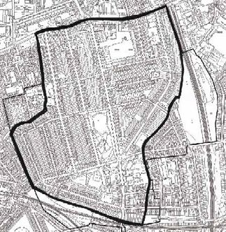
Contents
Introduction 4
The conservation area today 4
Planning policy 4
Public consultation and adoption 4
1 History of the area 6
2 Form and character of the area 13
Spatial character 13
Views 14
Streetscape 16
The natural environment 17
3 Buildings of interest and character areas 18
Character area 1: The Haberdashers’ Company’s late 19th
century development of Telegraph Hill comprising (a) Telegraph
Hill and (b) New Cross Road and Queens Road; 20
Character area 2: Mid 19th century and later development in
Dennett’s Road, Mona Road and Lausanne Road; 26
Character area 3: Good quality late 19th century development
outside of the control of the Haberdashers’ Company comprising
(a) Reservoir Road, Vesta Road and Sandbourne Road and
(b) eastern lengths of Pendrell Road and Drakefell Road; 27
Character area 4: Railway cuttings now designated nature reserves
comprising (a) New Cross Gate Cutting and (b) Nunhead Cutting; 30
4 Materials and details 33
5 The condition of the conservation area 37
Useful Contacts 38
Bibliography 39
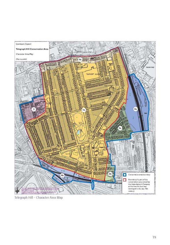
Telegraph Hill Character Area Map 19
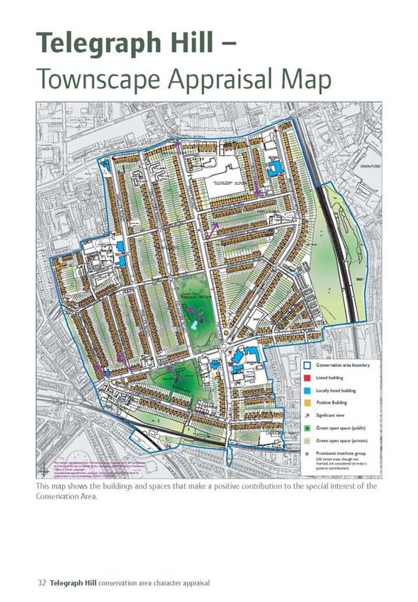
Telegraph Hill townscape appraisal map 32
3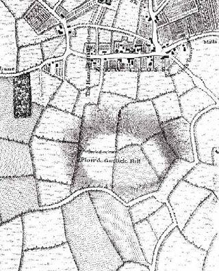
Introduction
Telegraph Hill Conservation Area was                     level course of Queens Road and New Cross Road
designated in 1990. The main body of the                 (part of the major roads A202 and A2 respectively),
conservation area was developed by the                   from where the land rises southwards to the public
Worshipful Company of Haberdashers during                park at the top of Telegraph Hill at c. 50 metres
the later part of the nineteenth century.                above sea level.
The Telegraph Hill Conservation Area is an               The conservation area measures 0.77 square
exemplar of a late Victorian planned residential         kilometres in area (c.200 acres) and contains
suburb that included (and still includes)                approximately 2,600 buildings. It was developed as
schools, places of worship and public parks all          a residential estate and remains so today. Though
designed and built as an integral part of the            the 19th century houses were built for occupation
neighbourhood.                                           by single families, many have now been divided into
Conservation areas are designated by the                 flats or student accommodation. Late 20th century
Council for their special architectural or               blocks of flats occupy the sites of major World War
historic character and appearance. Character             II bomb damage in Ommaney Road and Erlanger
Appraisals are written to provide information            Road.
on this special character. However, they are             There is a row of shops between nos. 256 to 268
not comprehensive studies and any omissions              New Cross Road and a large London Bus depot
do not therefore imply that an element does              with space for up to 300 buses located between
not contribute to the character of the area.             Troutbeck Road and Pepys Road. Further west
                                                         along this busy highway stands the New Cross
                                                         Fire Station. The area also includes three schools/
The conservation area                                    colleges, a corner shop, a public house, community
today                                                    centre and café, surgery, public park and at least
                                                         three active places of worship. The area is bounded
The Telegraph Hill Conservation Area is located          to south and east by railways whose leafy deep
mainly on the slopes of Telegraph Hill in south-east     cuttings have been designated sites of nature
London. The northern boundary is formed by the           conservation importance.

Semi-detached house in Erlanger Road                     Paired houses in a terrace in Waller Road

4 Telegraph Hill conservation area character appraisal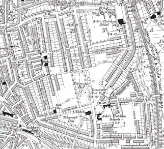
Queens Road and New Cross Road are busy
highways with the accompanying adverse impact
                                                      Public consultation and
of noise and air pollution. With the exception of a
secondary vehicular through route along Lausanne
                                                      adoption
Road (A2214), Gellatly Road and Drakefell Road        This appraisal is part of a wider review of the
(B2142), other roads within the conservation area     management of Telegraph Hill Conservation
are generally quiet and carry low levels of traffic.   Area which was carried out by the Conservation
                                                      and Design team and their consultants, The
Planning policy                                       Conservation Studio in 2007. The review included
                                                      this appraisal, a review of the boundaries of the
                                                      conservation area, the adoption of locally listed
The Council has a duty to formulate and publish
                                                      buildings and measures to control alterations
proposals for conservation areas and to pay special
                                                      to houses in the conservation area. Public
attention to the desirability of preserving or
                                                      consultation was carried out on these matters
enhancing the character of such areas. Character
                                                      in September and October 2007 in accordance
appraisals are a material consideration in the
                                                      with the Council’s Statement of Community
planning process and are used when determining
                                                      Involvement. Following support from local
planning applications and appeals. Other planning
                                                      residents, this appraisal was adopted by the Mayor
policies may also be taken into consideration when
                                                      and his Cabinet on 19 March 2008. An Article
we consider planning applications and these are
                                                      4(2) direction was also made to control external
available in our Unitary Development Plan and our
                                                      alterations of houses in order to preserve or
emerging Local Development Framework.
                                                      enhance the character of the area. This direction
                                                      came into effect on 9 April 2008. Six buildings
                                                      and three boundary markers were locally listed
                                                      following the review and the boundary of the
                                                      conservation area was not changed.

Three storey house in Queens Road                     Nos. 157 and 159 Jerningham Road

                                                                                                     5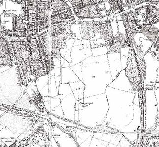
1 History of the area
                                                         The manor of Hatcham-
                                                         Bavant or Hatcham-Barnes
                                                         in which Telegraph Hill is
                                                         situated is an off-shoot of
                                                         the manor of Hatcham. The
                                                         parent manor was, at the
                                                         time of the Domesday Book
                                                         of 1086 in the hands of the
                                                         Bishop of Lisieux and its
                                                         assets were recorded as 3
                                                         hides, 3 ploughs, 6 acres of
                                                         meadow and woodland worth
                                                         3 hogs. The name Hatcham
                                                         is Anglo-Saxon and may be
                                                         derived from ‘Hacci’s village’
                                                         or ‘the village clearing in the
                                                         woods’.
The semaphore telegraph station c. 1800
                                                         A succession of owners held the
                                                         manor of Hatcham, including
                                                         the Crown, until in 1614 it
                                                         was bought by the Worshipful
                                                         Company of Haberdashers.
                                                         The Worshipful Company of
                                                         Haberdashers is one of the
                                                         ancient guilds of the City of
                                                         London. It has its roots in a
                                                         medieval fraternity, a group of
                                                         people who lived in the same
                                                         area doing the same sort of
                                                         work and who worshipped at St.
                                                         Paul’s Cathedral. Haberdashers
                                                         traded ribbons, beads, purses,
Pepys Road at the start of the 20th century              gloves, pins, caps and toys, and
                                                         later hats as well. The Company
                                                         had the right to search all
                                                         haberdashers’ shops within
                                                         three miles of the City, and to
                                                         destroy goods which were not
                                                         up to standard.

6 Telegraph Hill conservation area character appraisal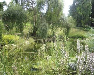
By 1650 the population of
London had grown to such
an extent that it was no
longer possible to control the
haberdashery trade and, over
a period of time, the Company
moved away from its historical
involvement in the trade of
haberdashery and developed
into a supporter of schools and
education in England and Wales.

The Hatcham estate, an immense
area of farming land stretching
from North Peckham to
Brockley, was bought to provide
an endowment for William
Jones’ school and almshouses        Part of the Haberdashers’ Aske’s Hatcham College, formerly the
in Monmouth, Wales. Jones           Boys’ School
was a successful haberdasher
and Hamburg merchant who
left a great fortune to the
Haberdashers to maintain his
charitable foundation.

John Rocque’s map of c.1740
shows that the land of today’s
conservation area was almost
exclusively agricultural although
the map does illustrate some
development immediately on
either side of today’s New Cross
Road.

Telegraph Hill is marked on
Rocque’s map as ‘Plow’d Garlic
Hill’ which may derive from the
name of a family or perhaps
the fact that garlic was grown
locally. Telegraph Hill owes its
present name to the fact that
its highest point was formerly
one of the stations on the line     Part of the Haberdashers’ Aske’s Hatcham College, formerly the
of semaphores, established in       Girls’ School

                                                                                                     7
1795, which were used by the
                                                         Admiralty before the invention of
                                                         the electric telegraph. Telegraph
                                                         Hill was on the communication
                                                         line between London, Deal and
                                                         Dover. It was used to bring
                                                         news of Wellington’s victory at
                                                         Waterloo in 1815.

                                                         Development of the area first
                                                         started in 1793 when the
                                                         Croydon Canal was built. In
                                                         the mid 19th century the canal
                                                         was converted to a railway
                                                         with New Cross Gate station
                                                         opening in 1839. The arrival
Telegraph Hill Park, entrance and bandstand, c.1910      of the railways resulted in a
                                                         huge rise in the development
                                                         potential of the Haberdashers’
                                                         land and in 1858 the Company
                                                         set up a committee, later
                                                         called the Hatcham Manor
                                                         Estate Committee, “with
                                                         power to originate and receive
                                                         suggestions for the laying out
                                                         and management of the estate
                                                         at New Cross”. By the late1860s
                                                         the majority of the land on the
                                                         north side of today’s New Cross
                                                         Road was under development
                                                         (much of this development now
                                                         forms the Hatcham Conservation
                                                         Area). An indication of the rapid
                                                         rate of urbanisation is shown
                                                         by the increase in Hatcham’s
                                                         population. It had increased
                                                         from 734 inhabitants in 1801
                                                         to 1,555 in 1831 but during the
                                                         next 40 years to 1871 it rose to
                                                         17,168.

                                                         Telegraph Hill, on the south
                                                         side of New Cross Road,

8 Telegraph Hill conservation area character appraisal
remained undeveloped until
the 1870s, probably because
the steepness of the hill
made it a less commercial
proposition. However, in 1861
the Haberdashers’ Company put
forward plans to develop the
Hill. The Company instructed
its surveyor William Snooke to
survey it with a view to house-
building. He recommended the
laying out of wide tree-lined
streets for the erection of houses
of a high standard and the first
street of terraced houses was
built in 1871.
Pepys Road and Recreation Ground, c.1905
An early building was
Haberdashers’ Aske’s Hatcham
Boys’ School for which four
acres of land were acquired
utilising funds bequeathed in
1688 by Robert Aske, citizen
and haberdasher. When the
school was opened in 1875
it was reported that “there
was not a paved road or a
house within some hundreds
of yards of it and the party
of Haberdashers’ Company at
the opening ceremony had to
dismount from their carriages
and walk along planks placed
across the mud…” There were
originally two schools on this
site, one for 300 boys and one
for 200 girls but as the estate
expanded and local population
grew the accommodation proved
insufficient and a new school
for 400 girls was opened at the
bottom of Jerningham Road in
1891.
9The growth of the
neighbourhood from 1870
onwards was very rapid. The
farming land sublet by the
Haberdashers’ Company to
tenants for farming (Manor Farm
and Hatcham Farm) and large
villas (Fairlawn, Hatcham Manor
House, Field House) just south
of New Cross Road was amongst
the first to be developed. A
comparison of the Ordnance
Survey maps published in 1868
and 1894 shows how in a period
of less than 20 years an expanse
of former nursery grounds
and market gardens had been
subsumed by a grid-pattern
development of residential
streets, three schools, public park
and church.
The growth of Hatcham’s
population provided a strong
justification for a public park.
With grants from George
Livesay (1834-1908), a local
philanthropist and chairman
John Rocque’s map of c.1740 of the South Metropolitan Gas
Company, the Parish of Deptford
and the London County Council,
Telegraph Hill Park opened
in 1895. The park contained
ornamental wrought-iron
perimeter railings and gates, a
stone drinking fountain and a
band-stand. Having fallen into
disrepair by the 1980s, the park
was restored with the aid of
the Heritage Lottery Fund and
formally re-opened in 2005.
10 Telegraph Hill conservation area character appraisalIn addition to the Haberdashers’
Aske’s Hatcham Schools (now
Haberdashers’ Aske’s Hatcham
College) a London School Board
school was established in Waller
Road on 1887. The Church of
St Catherine’s was built and
endowed by the Haberdashers’
Company in 1894 at a cost of
£20,000, designed by Henry
Stock A.R.I.B.A. Stock was
appointed surveyor to the
Haberdashers’ Company in
1882 and was also responsible
for the adjacent vicarage and
Haberdashers’ Aske’s Hatcham
Girls School (1891). The church
was popularly rumoured to have
been the subject of an attack
by suffragettes when it was
damaged by fire in 1914. It was James Wyld’s map of 1848
damaged by fire again in 1940
due to World War II bombs. In The area’s schools, places of
1971 the church was altered and worship and park remain albeit
extended by the addition of a restored and refurbished to
community centre. meet the demands of 21st
century living. Telegraph
In 1900 Telegraph Hill was a Hill has a strong sense of
popular and desirable newly- community and the Telegraph
built middle-class suburb Hill Conservation Area
with convenient near-by rail continues to be a popular place
connections to central London. of residence.
During the twentieth century the
Haberdashers sold off the estates
to private owners but there has
been little change to the area’s
street pattern and almost all of
the original late 19th century
houses remain (some were
destroyed during bombing raids
of World War II).
11Ordnance Survey 1868 Ordnance Survey 1894 12 Telegraph Hill conservation area character appraisal
2 Form and character
  of the area
Spatial
character
The built environment of the
conservation area was laid out in
a planned and uniform manner
over a relatively short period.
The regularity of the street
pattern and the consistency of
the building line is one of the
area’s most strongly defining
features.

Buildings follow a strict building
line running parallel to the
highway and set back behind          Strongly defined building line in Ommaney Road
small front gardens that were
originally bounded by iron
railings. Rear gardens are
long especially those in Waller,
Erlanger and Pepys Road – a
reflection of the high status
of the dwellings. Unusually
there are no ‘back lanes’ or
service roads to provide access
to the rear of properties. This
has prevented the building of
rear garages and other modern
accretions that sometimes
mar the character of similar
developments. The large areas
of open space created by rows
of back-to-back rear gardens
add to the local distinctiveness     Wide carriageway and pavements, Jerningham Road
of the area.

                                                                                       13
There are only three
developments to deviate from
the strongly defined building
line: the central block of Aske’s
School, which was presumably
deliberately aligned to present
its façade and a triangular
forecourt (now containing a
statue of Robert Aske) to the
junction of five estate roads,
and two late 20th century
flatted developments which
replace 19th century houses
destroyed by World War II
bombs i.e. Jerningham Court in
Ommaney Road and Cypress,
Views to central London from Upper Park Cedar, Myrtle and Rowan
Houses in Erlanger Road.
Views
The conservation area is notable
for the long distance views
north-west to landmarks in the
centre of London available from
the top of the hill in Telegraph
Park. The Houses of Parliament
are clearly visible to the north
west from Upper Park as are
Battersea Power Station, the BT
Tower and the London Eye.
The view down Jerningham
Road which includes views
of the Dome and the City of
The Fire Station’s look-out is a local landmark London is best appreciated in
winter when the trees are not in
foliage.
14 Telegraph Hill conservation area character appraisalBecause of its elevated position
similar, but less extensive views,
can be gained from the top of
Bousfield Road and Gellatly
Road and from the lawn above
the park-keeper’s cabin in
Lower Park. From the west end
of Ommaney Road there is a
distant view north eastwards Old stone kerbs in Erlanger Road Remnants of 19th century iron
to tall buildings in London railings
docklands.
There are good views of the
backs of houses, as uniform
in design as the fronts, and
across green back gardens from
where the east-west side roads
(e.g. Arbuthnot, Ommaney and
Sherwin Roads) cut between the Tiled footpath in Waller Road St Catherine’s churchyard
primary north-south roads.
Generally speaking, the
conservation area’s buildings are
notable for the unity of building
height. There are few tall
buildings of landmark quality
except for the turrets of the Fire
Station and the Aske’s Schools.
No. 133 Pepys Road has a
prominent location overlooking
a road junction but this is not
reflected in any departure from
the approved house design.
Traffic control measures in Gellatly Road
15Streetscape
Whilst many streets retain stone
kerbs of varying length, the
floorscape is predominantly
modern, composed of black
tarmac highway and pavements
of concrete slabs and tarmac.
Street lighting is modern. Bus
shelters and traffic calming
measures such as road bumps,
coloured road surface and
street narrowing devices,
though necessary, do not sit
well with the strong historic
character and appearance of the
conservation area because of
their uncompromisingly modern
materials, colour and design.
Street trees in Erlanger Road The public realm is enhanced
by small details such as street
names painted onto house walls
and occasional Haberdashers’
Company plaques. A few
‘traditional’ bright red letter
boxes and telephone kiosks (of
which four are grade II listed)
struggle for attention amidst the
plethora of unsightly wheelie
bins that often clutter the
pavements.
16 Telegraph Hill conservation area character appraisalto create a pleasant green east. The undisturbed sloping
The natural ambience at the heart of this sides of the deep cuttings
environment urban conservation area. through which the railways pass
have considerable ecological
The largest public open space in Street trees are one of the interest. From within the
the area is Telegraph Hill Park, defining characteristics of the conservation area they are only
divided by Kitto Road into two conservation area. Mature visible from the bridges at the
areas known as Upper Park (to London planes and lime trees ends of Vesta Road and Pepys
the south of Kitto Road) and adorn the area particularly in Road.
Lower Park (to the north). Both Pepys Road, Jerningham Road
parks have recently (2004-5) and Waller Road. Less majestic The birch woodland occupying
undergone extensive restoration trees can be seen in Bousfield most of the New Cross Gate
and replanting. Road and the roads running Cutting is of fairly recent origin,
east-west. Lombardy Poplars birch being a pioneering species
The Upper Park is laid out originally planted along the rear particularly on nutrient poor
with viewing point, lawns and garden boundaries of the main soils. The cutting forms part
picnic area bounded by trees roads have been complemented of an extensive railway cutting
and shrubs. Lower Park, the by more recent trees and reserve between New Cross
larger of the two parks, has a shrubs to create pleasant green Gate and Forest Hill stations,
more consciously landscaped environs not visible from the the most representative site in
atmosphere than Upper Park public highway. London for habitats developing
containing two ponds and a on active rail sites.
cascade crossed by a small The residential area is bounded
bridge, sinuous footpaths across by railways to the south and
sloping lawns and a restored
park-keeper’s cabin.
Telegraph Hill Park was
described at its opening in 1895
as the ‘smallest of London’s
lungs’. The two parks continue
to provide a valuable green
breathing space and make a
good setting for the houses in
Pepys Road and Erlanger Road
which overlook the site.
Both parks contain fine mature
trees and other greenery which,
together with the yews in St
Catherine’s churchyard and trees
in the north-west forecourt
of Aske’s School, combine The pond in Lower Park
173 Buildings of interest
and character areas
The Telegraph Hill Conservation Area can be divided into four discernible ‘character
areas’, each one unified by a similarity of historic development, land use or architectural
character.
The four character areas are:
• Character area 1:
The Haberdashers’ Company’s late 19th century development of Telegraph Hill comprising (a)
Telegraph Hill and (b) New Cross Road and Queens Road;
• Character area 2:
Mid 19th century and later development in Dennett’s Road, Mona Road and Lausanne Road;
• Character area 3:
Good quality late 19th century development outside of the control of the Haberdashers’ Company
comprising (a) Reservoir Road, Vesta Road and Sandbourne Road and (b) eastern lengths of
Pendrell Road and Drakefell Road;
• Character area 4:
Railway cuttings / sites of nature conservation importance comprising (a) New Cross Gate Cutting
and (b) Nunhead Cutting;
All the historic buildings in the conservation area make a positive contribution to its distinctive character
and appearance. These ‘positive’ buildings are identified on the townscape map on page 32.
As recommended in Planning Policy Guidance 15: Planning and the Historic Environment, the general
presumption is in favour of retaining all buildings which make a positive contribution to the character or
appearance of a conservation area.
18 Telegraph Hill conservation area character appraisalCharacter Areas
Individual listed buildings,
locally listed buildings and
other buildings of architectural
significance are featured within
the relevant character area
below.
Character area 1:
The Haberdashers’
Company’s late 19th
century development
of Telegraph Hill
comprising (a)
Telegraph Hill and (b)
Nos. 71 and 73 Pepys Road New Cross Road and
Queens Road;
This character area includes
all of the houses built under
the control of the Worshipful
Company of Haberdashers in the
period 1870-1899.
Character area 1a:
As soon as one moves away
southward from New Cross Road
(character area 1b), there is an
increasing feeling of suburban
tranquillity engendered by
street trees, boundary hedges
and a huge reduction in traffic
movement and noise.
Three storey red-brick row in Pepys Road
The London Bus garage which
includes a non-descript building
and large areas for parking breaks
the prevalent rectilinear pattern
of rows and terraces of houses
south of New Cross Road. Its
20 Telegraph Hill conservation area character appraisalpotentially detrimental impact on
the streetscene is minimised by
surrounding development which
shields most of it from public
view.
The four wide tree-lined
roads that lead uphill from
New Cross Road and Queens
Road form the core of the
prestigious Haberdashers’ estate.
The houses were built to a
standardised design, mainly by
two firms of builders. They are
predominantly two storeys with
basement, the front entrance
usually approached up a flight
of steps. The basement storey Statue of Robert Aske, Pepys Road (Grade ll Listed Building)
obviously provided more floor
space but may also have been
a response to the incline of the
hill. Waller Road is terraced
although the houses are paired
in design. It is the most uniform
road in the area. In contrast,
Erlanger, Pepys and Jerningham
Roads are predominantly lined
by semi-detached houses which
have a similar design to the
terraced pairs in Waller Road i.e.
central paired front entrances,
canted bays rising the full height
of the building under a hipped
slate roof. Narrow gaps between
buildings reveal green gardens
to the rear. The houses are well
London Board School, Waller Road (1887) - a Locally Listed Building
set back from the road with
front gardens and, formerly, a
grass verge at the front of the
pavement.
The lower ends of Jerningham
and Pepys Roads were
21developed earlier than the
upper slopes of the hill and
this is reflected in their form
and plan which differs from the
vast majority of Haberdashers’
houses. The architecture of
nos.1-23 (odd) Jerningham
Road and nos. 1-37 (odd) and
nos. 2-32 (even) Pepys Road
has more in common (e.g. three
full storeys) with the more
massive developments in New
Cross Road.
The other roads in this area
are built to a smaller scale with
a narrower carriageway and
Public House, No. 1 Kitto Road (c1890) - a Locally Listed Building smaller front gardens. Bousfield
Road, Gellatly Road and the
west end of Arbuthnot Road
form an architecturally cohesive
sector of two storey terraces of
almost identical design. Their
scale, in comparison to the
four main roads, reflects the
lower social class of the original
residents. Ommaney Road and
Musgrove Road (the last road
to be completed c.1900) follow
the contour of the hill and
therefore, because of the fall,
have basements.
The street pattern was laid out
in the 1870s to follow a roughly
north-south and east-west
Church of St Catherine (1894) - a Locally Listed Building grid pattern, ignoring existing
field boundaries. The most
prestigious streets (Waller Road,
Erlanger Road, Pepys Road and
Jerningham Road) being placed
along the central north-south
axis (Jerningham Road is forced
22 Telegraph Hill conservation area character appraisalto bend to the south-east to
accommodate the contours of
the hill and the limited eastward
extension of Haberdashers’
land). These roads are wider
than the east-west side-streets
and the streets on the periphery
of the area.
The Architect in 1875 reported:
“The Hatcham Manor Estate
which exceeds two hundred
acres in extent is now being
laid out for building purposes
by the Haberdashers’ Company
to whom it belongs…Nothing
but buildings of a superior class,
including villas and high class Haberdashers’ Aske’s Boys’ School (1875) - a Locally Listed Building
mansions will be permitted
to be built on the estate…A
general architectural design has
been agreed upon…the several
elevations must be to a large
extent uniform with it…and
must receive the approval of the
Haberdashers’ Company”.
This character area contains two
listed buildings: a K2 telephone
kiosk in Jerningham Road and
the statue of Robert Aske in the
forecourt of Aske’s School is
also listed grade II. K2 cast-iron
telephone kiosks, designed by
Giles Gilbert Scott in 1927, are
distinguished by their domed
Haberdashers’ Aske’s Girls’ School (1891) - a Locally Listed Building
roof, perforated crowns in the
top panel and glazing bars to
windows and doors. The Coade
stone statue of Robert Aske is in
the robes of the Livery Company
and is signed ‘Croggon,
Lambeth, 1836’.
23There are five non-residential
buildings that were built
as an integral part of the
Haberdashers’ estate:
Haberdashers’ Aske’s Boys’
School (1875); Haberdashers’
Aske’s Girls’ School (1891);
London Board Schools, Waller
Road (1887); Public house, No.
1 Kitto Road (c.1890) and the
Church of St Catherine (1894).
These buildings are an intrinsic
part of the overall conception
of the estate, have notable
architectural and historic merit
and are therefore locally listed
buildings.
Row of shops in New Cross Road
Character area 1b:
The New Cross Road/Queens
Road thoroughfare is an ancient
road that divided the old manor
of Hatcham. The land north
of this road was developed by
the Haberdashers’ Company
from the 1860s onwards and
this now forms part of the
Hatcham Conservation Area.
The character of the road
is part commercial and part
residential. Because of its role
as a main arterial London road
the road carries a high level of
traffic along four lanes with
a consequent high level of
noise and air pollution. Busy
No. 318 Queens Road
bus stops, shops and a nearby
college result in a high footfall
along the pavements, especially
at peak times, and create a
general feeling of activity and
movement.
24 Telegraph Hill conservation area character appraisalThe central length of the road foliated capitals, paired doors
(south side) is dominated by under a segmental pediment,
Fairlawn Mansions (c.1910), two red brick eaves course) that
massive blocks of residences, are so prevalent in the streets
three storeys with basement, behind, in the main body of the
built in red brick with stone conservation area. No. 294 has
dressings. Their north facing a Haberdashers’ plaque fixed to
aspect and soiled appearance its front wall.
due to pollution give them an
austere appearance. The two The New Cross Fire Station
blocks are separated by the (1894) has an L-shape plan,
entrance to the London Bus four storeys with a six bay
depot, formerly a tram depot façade flanked on either side by
opened in 1906. projecting rounded turrets in a
faintly Baronial style, red brick
To the east of Fairlawn and clay tile roof. It holds a
K2 telephone kiosk, Troutbeck prominent corner location and,
Mansions, nos. 218 -238 New Road (one of four grade ll
Cross Road and all of Troutbeck rising well above surrounding
listed telephone kiosks in the development, it has landmark
Road is an interwar housing conservation area)
development that is out of quality. It is a locally listed
Queens Road has a less hectic building.
character with the late 19th
ambience and is enhanced
century appearance of the
by some fine street trees and There are three grade II listed
main body of the conservation
greenery in front gardens. Nos. K2 telephone kiosks in this
area but has its own particular
268-320 are three storeys and character area: Jerningham
1930s character. These two
begin to show some of the Road, Troutbeck Road and
20th century developments in
architectural features (e.g. Waller Road.
New Cross Road (bus depot
and interwar houses) occupy
the site of a number of earlier
villas, including Fairlawn, and a
building identified on the 1912
O.S. map as a laundry. Further
east, beyond a wall enclosing
Aske’s School, there is a parade
of shops in the ground floor
of an altered and neglected
three storey late 19th century
brick row originally called ‘The
Pavement’. Shopfronts are
modern, mostly in garish colours.
There are vestiges of earlier
shopfronts in the remaining
pilasters and consoles. New Cross Fire Station (1894) - a Locally Listed Building
25Character area 2: Nos. 110-116 Dennett’s Road
(on the west side) is a short
Mid 19th century and row of mid 19th century two
later development in storey brick built houses with
paired first floor windows and
Dennett’s Road, Mona roofs concealed behind parapets
Road and Lausanne with stucco cornice, much
altered by the introduction of
Mid 19th century houses in Road; uPVC windows and removal of
Dennett’s Road architectural details. Nos. 82-90
This small area in the west of have a similar scale and design
the conservation area pre-dates but with a different style of
the Haberdashers’ development window and door surround (the
having been constructed former with flat arch, the latter
c.1850. The 1868 O.S map with segmental arch) probably
shows the grid of Carlton Road reflecting the different designs
(now Walsham Road), Dennett’s of two different builders, even
Grove, Butts Road and Victoria within the same street. Nos
Road (now Mona Road) 1- 7 Mona Road date from the
immediately abutting an area of same period.
open hillside to the east.
Nos. 61 and 63 Lausanne Road In contrast, just around the
This character area has some corner, nos. 61-67 Lausanne
good examples of early Victorian Road (c.1900) shows the
terraced houses. It contains a changes in house design that
diversity of house building style has occurred in 50 years.
in a very small area and thereby These houses are modulated
provides a good contrast to by ground floor canted bay
the regularity of house design window, pitched roofs and eaves
within the main part of the have replaced parapets and
conservation area (character front doors are slightly recessed
area 1). within a small porch.
The area has undergone great The variety in house design,
changes, including bomb the presence of a former large
damage and demolition, warehouse and differences
especially east of Dennett’s in scale on the east side of
Road where the Edmund Waller Lausanne Road is reflected in an
Infants School and Walsham inconsistent roofline along the
House now stand on the site street. The road has cars parked
of mid 19th century terraced on either side and is busy with
houses. traffic.
26 Telegraph Hill conservation area character appraisalCharacter area 3: Two boundary markers are
located at the back of the
Good quality pavement outside no. 61 Vesta
late 19th century Road. One of these is a short
iron post topped by a cube
development outside with KENT and SURREY on
of the control of opposite faces and it marked
the boundary between Kent and
the Haberdashers’ Surrey, the other is a truncated
Company short metal bollard which marks
the limit of the Haberdashers’
Comprising (a) Reservoir Road, estate. These markers and a
Vesta Road and Sandbourne similar Haberdashers’ metal
Road and (b) eastern lengths bollard in a piece of waste
of Pendrell Road and Drakefell ground beside the flats in
County boundary marker - a
Road; Sandbourne Road are notable
Locally Listed Building
items of historic interest and
This area comprises two locally listed buildings.
distinctly separate areas that are
not part of the Haberdashers’ From here Vesta Road descends
19th century development but to a bridge over the railway.
nevertheless have considerable On the south side the road is
architectural and historic notable for houses that rise to
interest. Being on land a full three storeys, those at the
outside the ownership of the top of the hill having a third
Haberdashers’ Company, the storey lit by wide brick ‘dormers’
houses were not built with the with three windows above two-
same restrictions. storey canted bays. The design
appears crude in comparison to
Character area 3a: the well proportioned houses
Reservoir Road, Vesta Road of say, Pepys Road. Further
and Sandbourne Road: This down the south side of Vesta
triangular character area Road are pairs of three-storey
comprises three residential roads houses with a distinct lack of
just west of the New Cross Gate architectural embellishment that
railway cutting. There are only marks them out as qualitatively
different to the Haberdashers’ Haberdashers’ Company marker
a few houses of historic interest beside the flats in Sandbourne
in Sandbourne Road as the east development. Some of these
appear to have been converted Road - a Locally Listed Building
side has been redeveloped with
late 20th century residential to flats and the ensuing lack
blocks. of maintenance of the front
garden is detrimental to the
streetscene.
27No. 30 Vesta Road is dated
1906, a late addition and,
unusually, built with red brick.
Reservoir Road comprises short
rows of houses arranged in pairs
with paired front doors under a
segmental pediment enriched
with foliage and a central face,
two storey canted bays flank
the entrance and wide eaves
are supported on numerous
decorative timber brackets.
Often the name of the house
(e.g. St Anne’s Cottage,
Pendennis) has been incised
above the front door.
Nos.18 and 20 Reservoir Road
No 1 Reservoir Road has been
designed to celebrate its corner
location and boasts a two
storey projecting corner bay
with a red brick dentilled eaves
course. The road is particularly
notable for the ornamental
tiles that decorate the sides
of the recessed front porches
Tiled front path and cast iron although, regrettably, some
railings porches have been enclosed.
Three storey development in A full set of clay chimney pots
Vesta Road
28 Telegraph Hill conservation area character appraisalCharacter area 3b:
Nos. 29-35 and 26-36 Pendrell
Road and nos. 107-131 and
172-196 Drakefell Road;
This character area well
illustrates the contrast between
Haberdashers’ and non-
Haberdashers’ building. Of
particular note is the abrupt
break in house style between
no. 105 and no. 107 Drakefell
Road that vividly illustrates
the change in land ownership.
No. 105 is the most easterly of
the Haberdashers’ houses in
Drakefell Road and, on plan,
its eastern flank wall can be
seen to be canted to follow Nos. 23 and 25 Pendrell Road
exactly the boundary line of
the Haberdashers’ estate. A
small Haberdashers’ plaque
is fixed to the façade of no.
105 and a similar plaque set in
the boundary wall of no. 170
opposite marks the limit of the
Haberdashers’ land.
The transition is not so
noticeably marked at the east
end of Pendrell Road although
the break can be told by the
wide gaps between nos. 27/29
and 24/26 where the terraces of
over 12 houses to the west give
way to the short rows of houses
to the east. Unusually no. 36
No. 105 Drakefell Road, the eastern limit of the Haberdashers’ estate
Pendrell Road is built with red
brick.
29Character area 4:
Railway cuttings
/ sites of nature
conservation
importance
comprising (a) New
Cross Gate Cutting
and (b) Nunhead
Cutting;
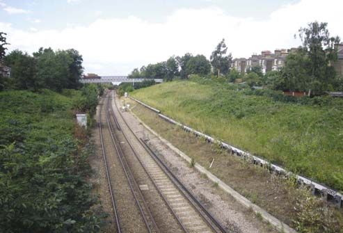
New Cross Gate Cutting
(character area 4a) is the larger
of the two railway cuttings. It
was excavated by the London
and Croydon Railway Company
after buying the Croydon Canal
in 1836. Between here and
Forest Hill half a million cubic
metres of soil were removed by
The part of the conservation area owned by the Haberdashers’ navvies working only with hand
Company at the time the land was developed in the late 19th century tools. Earthworks since the
railway opened in 1839 have
resulted in the site becoming
a series of terraces down to
the railway line. The woodland
occupying most of the site is of
fairly recent origin, previously
the slopes were more intensively
managed by British Rail and
grassland predominated. Since
1987 London Wildlife Trust has
managed the site as a nature
reserve.
The wide shallow cutting
between New Cross Gate and
Forest Hill stations contain
The diagonal line to the right of the plan follows probably the finest suite of
the boundary of the Haberdashers’ estate railside wildlife habitats in
30 Telegraph Hill conservation area character appraisalLondon. Around 4 km long, this
is a huge swathe of high-quality
habitat reaching right into the
densely populated urban north
of Lewisham Borough.
Nunhead Cutting (character
area 4b) was created during
construction of the London
Chatham and Dover Railway
c.1870. It has an east-west
orientation and is vegetated
with a mosaic of woodland
(mostly sycamore), scrub and
rough grassland.
New Cross Cutting Nature Reserve
Trees and greenery beside Nunhead Cutting
314 Materials and details
Walls and roofs
Building materials and
architectural details play a
significant role in forming an
area’s special character and
appearance. The houses in the
Telegraph Hill Conservation
Area are remarkable for the
prevalent use of a limited
palette of building materials.
Walling is predominantly yellow
London stock brick with stucco
dressings (to imitate stone) and
occasional red brick recessed
panels or string courses. Brick
colours come in a range of ‘Fishscale’ effect of slates
yellow/brown hues and textures
and, unexpectedly, a few houses
are built with red brick (e.g. no.
32 Pendrell Road). Brickwork
of houses is invariably laid in
Flemish bond. Brickwork on
the garden walls is more often
in English Garden bond. Of
particular note is the walling
of the Haberdashers’ Aske’s
Hatcham Girls’ School which has
inlayed designs.
Some non-residential buildings
such as the fire station,
Haberdashers’ Aske’s Girls’
School, public house and
vicarage are also built with red
brick. Brickwork is invariably laid The Vicarage, Pepys Road
in Flemish bond i.e. alternating
headers and stretchers. St
Catherine’s Church is built of
natural stone.
33Roofs were originally covered
with Welsh slates although in
many instances natural slate
has been replaced with ridged
concrete tiles to the detriment
of the house’s appearance. A
fishscale effect remains on many
hipped bays. These should be
preserved or replicated.
Windows
Ornamentation of window
surrounds varies between streets
adding diversity amidst the
overall uniformity of the estate.
Original windows are almost
exclusively timber vertical
sliding sashes. The prevalent
glazing pattern consists of two
panes in each sash for the upper
floor and one pane per sash in
the lower floor. Where this no
longer occurs it is because of
modernisation.
Doors and
porches
Many houses in the
conservation area retain their
original doors which are often
set within elaborately detailed
recessed porches enhanced
by ornamental tiled side walls
which help create an attractive
entrance to the house and add
to its status. Robust, panelled
timber doors are common,
the upper panels glazed with
34 Telegraph Hill conservation area character appraisalleaded lights or coloured glass.
Above the door decorative
rectangular and semi-circular
fanlights provide more light to
the internal hall. Many houses
have twin entrances beneath an
embellished stucco pediment
with ornamentation that
matches the adjacent window
surrounds.
Boundary
treatment and
front paths
Front boundaries were originally
bounded by metal railings set
in a low wall. Though many
remain, most were removed
at the start of World War II.
Arbuthnot Road is notable for
the retention of lengths of
original railings.
Though many historic front
paths have been lost, those
that remain are a valuable
asset to the conservation area.
Encaustic tiles in geometric
patterns and black and white
diadem patterns are both
common.
35Architectural detail The houses are rich in architectural detail especially, as noted, on door and window openings around which there area a wide variety of decorative effects. Clay ridge tiles, finials and rows of clay chimney pots on robust brick chimney stacks enliven the roofscape. Their loss is always regrettable. 36 Telegraph Hill conservation area character appraisal
5 Condition
  of the conservation area
As part of the assessment           located in the front roofslope,
of Telegraph Hill                   unauthorised satellite dishes,
                                    replacement of slate with
Conservation Area in 2007,
                                    concrete tiles or poor quality
a brief visual condition            artificial slate, incorrect bonding
survey of some of the               of new brickwork, rendering/
properties and the area in          pebble-dashing of original
general was carried out.            brickwork, removal of small
All of the original houses          architectural details such as tiled
                                    front paths, finials, ridge tiles
in the conservation area
                                    and clay chimney pots.
are over 100 years old.
The conservation area has,          Of particular note is the change
unsurprisingly, undergone a         caused by the loss of original
certain amount of change,           front boundary walls and the
not all of which is good            hard-surfacing of front gardens,
                                    usually to form a parking area.
quality and some of which
                                    Not only is the removal of wall
has been detrimental to             and garden regrettable in terms
the area’s character and            of the loss of historic fabric but
appearance.                         also because of the loss of an
                                    urban wildlife habitat and the
The general condition of            adverse impact of hard surfacing
the buildings in the area is        on water run-off.
good. There are no derelict         Some of the above alterations
properties and although some        may not have required planning
would benefit from routine           permission and have been
maintenance and repair,             carried out lawfully under
none are considered to be           ‘permitted development rights’.
at immediate risk of decay.         The Council has powers to
Telegraph Hill Park, after some     restrict permitted development
years of neglect, has been          rights by means of an Article 4
recreated and restored.             Direction.
Small changes to the external
appearances of individual
houses are beginning to erode
the special interest of the area.
Examples of such negative
alterations are: replacement of
timber sash windows with uPVC
or windows in a different style,
enclosure of recessed front
porches, obtrusive rooflights

                                                                          37
Useful contacts
London Borough of Lewisham
Website: www.lewisham.gov.uk Envirocall
Report fly-tipping, graffiti,
Planning Service potholes etc on the following
Laurence House phone number or websites:
Fifth floor, 1 Catford Road Tel: 020 8314 7171
Catford, London, SE6 4SW www.lewisham
visibledifference.org.uk
Planning and information desk: www.lovelewisham.org
020 8314 7400
Conservation and Urban Housing Needs Grants
Design team: Captial House
020 8314 6071/8533 47 Rushey Green
Planning Enforcement team: Catford, London, SE6 4AS
020 8314 8092 Tel: 020 8314 6622
Building Control Highways
Laurence House Wearside Service Centre
Second floor Wearside Road
Address as above Ladywell, London, SE13 7EZ
Tel: 020 8314 8233 Tel: 020 8314 2181
Lewisham Local Studies Street trees
and Archives Centre Wearside Service Centre
Lewisham Library (as above)
199-201 Lewisham High Street Tel: 020 8314 7171
Lewisham, London, SE13 6LG
Tel: 020 8297 0682
Other
The Telegraph Hill Society
Contact via the details posted on
www.thehill.org.uk/society/
38 Telegraph Hill conservation area character appraisalBibliography
Hatcham and Telegraph Hill by Raymond Thatcher published by Lewisham Local History Society (1982)
A History of St Catherine’s, Hatcham by Olive Palmer and Maud Foreman (1990)
Opening of Telegraph Hill, Hatcham by J. Sexby, London County Council (1995)
Re-opening of Telegraph Hill Park published by the Telegraph Hill Society (2005)
Hatcham Conservation Area Appraisal published by Lewisham Borough Council (2006)
Maps and old photographs from Lewisham Local Studies and Archive Centre
39For other formats,
including Braille, large
print, audio tape or
computer disc and for
further information
contact:
Planning Information
Desk, 020 8314 7400,
planning@lewisham.
gov.uk
Planning Service Produced by The Conservation
Laurence House Studio for Lewisham Council’s
1 Catford Road Conservation & Urban Design
Catford Team
SE6 4RU
Adopted: 19 March 2008
Printed: May 2008
Historic maps & photos:
Lewisham Local Studies
Centre
Visit www.lewisham.gov.uk
for all the latest news and
information about your
Council’s services, and the
range of job opportunities we
40 Telegraph Hill conservation area character appraisal currently have on offer.You can also read