Prepared for City of Whitehorse Planning and Sustainability Services By January 2018
←
→
Page content transcription
If your browser does not render page correctly, please read the page content below
Prepared for
City of Whitehorse
Planning and Sustainability Services

By
                                       January 2018

In association with

                       Ra ndy Lew is
                        C onsult ing
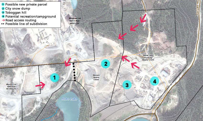
Table of Contents

1.0 INTRODUCTION                                                                                        2

2.0 OVERVIEW OF THE STUDY AREA                                                                          3

3.0 WHAT WE HEARD                                                                                       6

4.0 ROBERT SERVICE CAMPGROUND                                                                           8

5.0 LOWER BOWL/ SNOW DUMP                                                                              10

6.0 UPPER TERRACE/ESCARPMENT                                                                           12

7.0 EAR LAKE QUARRIES                                                                                  14

8.0 EAR LAKE RECREATION                                                                                16

9.0 TRAIL CONNECTIONS                                                                                  18

10.0 OTHER RECOMMENDATIONS                                                                             20

Acknowledgements:

The Project Team gratefully acknowledges the many individuals who provided their time, information,
thoughts and advice to the creation of this report. A list of governments, stakeholder groups, and individuals
consulted during the study can be found in the Robert Service Way Planning Study Background Report.

                                                    ROBERT SERVICE WAY PLANNING STUDY FINAL REPORT           1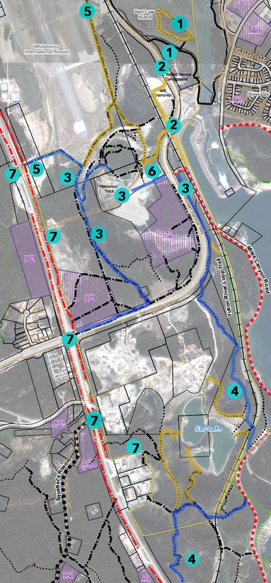
1.0 Introduction
Robert Service Way (RSW), formerly referred to as         commissioned a planning study into the RSW area
the “South Access”, is the main arterial road             to bridge any knowledge gaps. The objectives of
connecting the Alaska Highway to the southern             the study were to:
entrance of Downtown Whitehorse. This two/four-
                                                          • Assess ecological, wildlife, archaeological,
lane paved road roughly bisects a 337.85-hectare
                                                            heritage and recreational values;
area – herein referred to as the Robert Service Way       • Determine the likelihood of contamination
(or study) area - with a diversity of physiographic
                                                             issues;
features, land uses, and values.
                                                          • Explore development and servicing options for
Several planning studies have been undertaken in             the study area;
the past for the RSW area, the most recent being a        • Determine a vision for the remediation and
1997 Area Development Scheme. Since that time,
                                                             recreational use of the Ear and Hobo Lakes area;
numerous changes to land tenure and use in the
area have occurred, including:                               and,
                                                          • Review the existing function and future of the
• Both the Kwanlin Dün First Nation and Ta’an
                                                             ball diamond and campground area.
  Kwäch’än Council signed Final and Self
  Government Agreements that conferred
                                                          The project was carried out in three distinct phases
  ownership over two land parcels in the area;
                                                          as illustrated below. A comprehensive Background
• Planning was undertaken for the western shore           Report was issued in July 2017 to provide a baseline
  of Schwatka Lake in 2015 and the Order in               of information about the planning area prior to
  Council for the Chadburn Lake Park Reserve was          public engagement. This document contains a
  withdrawn in 2016;                                      summary of information provided in the Background
                                                          Report but is focused primarily on the final
• Yukon Energy Corporation constructed a liquid
                                                          recommendations of the Planning Team. Two stand-
  natural gas storage facility in 2015; and,
                                                          alone companion studies were also undertaken to
• The ten-year lease terms expired for two quarry
                                                          supplement the contents of the Background Report:
  operators situated in the Ear Lake area in
                                                          a Phase 1 Environmental Site Assessment and
  December 2016.
                                                          Heritage Resource Overview Assessment (both
In preparation for review of the Official Community       public and site-sensitive versions).
Plan (OCP) in 2018, the City of Whitehorse

                                                      Phase 2                            Phase 3
          Phase 1
                                             Background Report &                    Recommendations
   Information Gathering                      Public Engagement                       & Final Report
     FEBRUARY - JUNE                          JULY - SEPTEMBER                      OCTOBER 2017 -
           2017
                                                     2017                            JANUARY 2018

   2   ROBERT SERVICE WAY PLANNING STUDY FINAL REPORT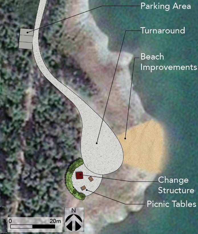
2.0 Overview of the Study Area
The Robert Service Way (RSW) study area is located            Land Tenure and Uses
within the City of Whitehorse municipal boundaries
south of the Downtown. The area is bounded by the             The Government of Yukon (YG) is the predominant
Erik Nielsen Whitehorse International Airport to the          landowner, followed by the City of Whitehorse.
north, Alaska Highway to the west, Yukon River                Land uses include:
and/or White Pass and Yukon Route (WPYR) railway
to the east, and the Ear Lake area to the south.              Vacant lands - The RSW study area consists of
                                                              predominantly undeveloped Commissioner’s lands.
Three distinct landscape features delineate the               The KDFN and TKC parcels are also vacant;
study area:                                                   portions of both were previously cleared and
                                                              quarried. A small YG parcel encompassing Ear
• Yukon River valley bottom – This includes                   Lake’s peninsula is a former life estate lease.
  the fluvial plain of the Yukon River and adjacent
  channel islands complex, which are home to                  Industrial/quarry operations - Industrial and
  Robert Service campground. To the west of RSW               quarrying operations occur on two private parcels
  is a portion of the Yukon River fluvial plain that          and two City leases in the Ear Lake area. Skookum
  forms a broad “C” shaped area, or bowl, that is             Asphalt Ltd. and Norcon Concrete Products Inc.
  occupied by a City snow dump (seasonally) and               own the private parcels, and Norcon and Annie
  Ta’an Kwäch’än Council (TKC) parcel C-28B.                  Lake Trucking Ltd hold the leases.

                                                              Recreation infrastructure - Formal recreation
• The upper terrace/escarpment – The
                                                              nodes include the Millennium Trail, Bert Law Park,
  western portion of the study area is separated
                                                              Robert Service Campground, the softball complex,
  from the Yukon River valley bottom by a steep
                                                              motocross track, and a “mud bog” event area.
  escarpment and occupied by the southerly
                                                              Informal recreation nodes include the river, Ear Lake
  portion of the airport reserve, Commissioner’s
                                                              and the local network of roads and trails.
  land, and Kwanlin Dün First Nation (KDFN)
  parcel C-34B.                                               Public utilities - The RSW area is home to the
                                                              Yukon Energy Corporation’s (YEC) Whitehorse
• Ear Lake complex – This complex of kettle-
                                                              Rapids hydroelectric facility, headquarters, and
  kame terrain comprises the area situated south
                                                              liquid natural gas (LNG) storage facility and
  of RSW and includes Ear and Hobo lakes.
                                                              generator. The City snow dump is its largest and the
  Approximately half of the area has been utilized
                                                              only one open to commercial snow removal
  for gravel quarrying since the 1950s.
                                                              contractors. YEC has a substation in the vicinity of
                                                              its power plant, which subsequently feeds into two
  Pho to below: Lo ng radius curve of R SW facin g north
  towards TKC parcel C-28 B.
                                                              ATCO power distribution lines that bisect Lot 1267.

                                                       ROBERT SERVICE WAY PLANNING STUDY FINAL REPORT         3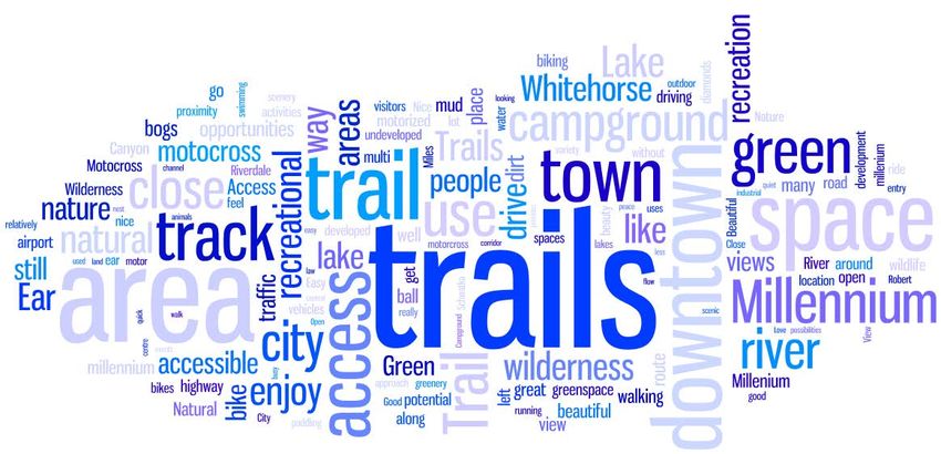
4 ROBERT SERVICE WAY PLANNING STUDY FINAL REPORT
3.0 Current Conditions
Geology and Terrain                                             Ecology

RSW’s three physiographic regions have different                The RSW area is home to three Environmentally
geological and terrain characteristics – and                    Sensitive Areas (ESAs), two of which are also
accordingly, different development opportunities                considered Significant Wildlife Areas. These include:
and constraints. The steep glaciolacustrine
                                                                1. Shallow, sheltered bays, open water, and riparian
escarpment of the Whitehorse valley and kettle-
kame features present in the Ear Lake area are the                 areas of small lakes, such as Ear and Hobo Lakes;
area’s predominant landscape features and                       2. The Riverdale-Yukon River Flats Wildlife Area;
development constraints.                                           and,
                                                                3. Steep, exposed silt bluffs below the airport.
Much of the valley bottom is deemed suitable for
development, with generally level, well-draining
sand and gravel near the surface and the water
table 2-3 metres below ground. The upper terrace
has good to moderate development potential, with
undulating topography and high erosion potential
of surficial sands posing some challenges.

                                                                Pho to abo ve : Water le ve ls h ave d ro ppe d sign ificantly
                                                                at Ea r L ake and th e exact cause is u nknown .

                                                                Ear and Hobo Lakes and surrounding area are
                                                                considered to have moderate to high
                                                                environmental sensitivity and provide habitat for
                                                                waterfowl and semi-aquatic mammals. Most of the
Pho to above: View o f the valle y bo tto m an d river
                                                                islands in the Riverdale-Yukon River Flats Wildlife
chann el islan ds fro m the escarpment
                                                                Area are permanently forested and, during periods
McLean Creek is the predominant up gradient water               of low water, mid-river islands can become
source, entering the study area from the west and               exposed gravel bars with willow-alder. Spawning
discharging into Hobo Lake, which has no outlet but             and rearing habitat for Chinook salmon and Arctic
is presumed to flow eastward to Ear Lake and                    grayling exists throughout the islands complex in
ultimately Schwatka Lake. The water levels in Ear               shallow side channels and along RSW. A small
and Hobo Lakes have fluctuated in the past but                  colony of Little Brown Myotis (bats), an endangered
have been on a consistent downward trend in                     species, has been documented along the bluffs
recent years due to unknown causes.                             below the airport; otherwise, this ESA is not
                                                                considered significant for wildlife. There are no
                                                                known rare plant species within the study area.

                                                         ROBERT SERVICE WAY PLANNING STUDY FINAL REPORT                 5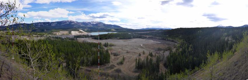
Heritage and Archaeology                                    solvents, etc. Of additional potential concern are
                                                            various adjoining current and historic land uses,
Several sites within the study area are of particular       including the Land Treatment Facility on airport
significance from a heritage and historical                 lands, quarrying and industrial activities on private
standpoint. The present-day Robert Service                  parcels near Ear Lake, WPYR and YEC operations,
Campground was a traditional fish camp for local            and the decommissioned pipeline on the western
Kwanlin Dün First Nation and Ta’an Kwäch'än                 side of the Alaska Highway.
people, site of a Kwanlin village, and a camp for
visiting First Nations. Its use as a recreational site by   Site Servicing
non-Indigenous Whitehorse residents dates back to
the 1920s. There are three known archaeological             There is no municipal water or wastewater service in
sites in the study area. A Heritage Resources               the study area at present. The most favourable
Overview Assessment concluded the highest                   option for connection to the City’s water system is
potential for heritage resources is located along           to create a watermain extension from the corner of
ridges and terraces where high, flat terrain breaks to      Condor Road, south of the airport. Similarly, a
downward slopes and waterfront areas.                       sewage connection would ideally tie into the
                                                            airport. These upgrades would likely be
                                                            necessitated by future residential development in
                                                            the Southern Urban Containment Boundary area
                                                            roughly extending from the south of Copper Ridge
                                                            to Canyon Creek.

                                                            Transportation

                                                            The two major roads located within the RSW area
                                                            are RSW itself and the Alaska Highway. The Ear
                                                            Lake Road is a secondary gravel road but does
                                                            connect to RSW at a signaled intersection. As of
                                                            early 2018, the Yukon Department of Highways and
                                                            Public Works has shelved a long-term functional
                                                            plan for the Alaska Highway through Whitehorse
Pho to abo ve: The WPYR railwa y o n a stee p bank          and will focus on priority safety improvements,
section ru nning alo ngside Ear Lake (no te the much
                                                            including the intersection with RSW.
highe r wa te r le ve l). (S ou rce : Yukon Archives)

Contamination Issues                                        Power

The Phase 1 Environmental Site Assessment for               Yukon Energy Corporation’s hydroelectric and LNG
public lands in the RSW area found that heavy               facilities are situated in the middle of the planning
vehicle movements and equipment storage                     area. About 1-1.5 megawatts of power capacity are
activities associated with the historic quarrying           potentially available to service development in the
activities, motorized sports, and the snow dump             RSW area currently; any power needs beyond this
have the potential to result in soil and/or                 threshold would trigger new upgrades in the $5
groundwater contamination by heavy metals, fuels,           million range.

   6    ROBERT SERVICE WAY PLANNING STUDY FINAL REPORT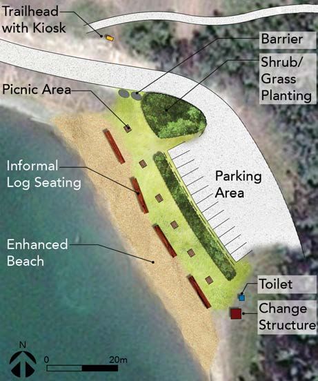
3.0 What We Heard
Overview
The stakeholder and public engagement
component of the study centered around two key
elements:
• Interviews with government representatives, etc.
With an interest in the study area; and,
• A survey (short and long version) that was
delivered online and in person at four “pop-up”
booths from July 28 to September 10, 2017.
The long survey included the same core questions Study Area Uses
as the quick survey (use of the study area, values,
general comments) as well as more detailed Survey participants were most likely to use the
questions about land uses, recreation, and Ear Lake. Millennium Trail (88%), drive through the study area
(85%), and use other trails in the area (59%). Users
RS W ENGAGE MENT , BY TH E NUMB ERS
Study Area Uses of the ball diamonds and motocross track were well
represented in the survey (21% and 17% of
• 16 government & stakeholder interviews
respondents, respectively). 23% of participants
• 176 public surveys (short version)
indicated using the area for other activities,
• 300 public surveys (long version)
primarily paddling, swimming, and watching the
• 257 social media interactions
mud bogs.
• Neighbourhood of residence: Riverdale -
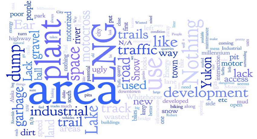
28%; Porter Creek – 11%; country residential Below: Fr eq uent ly occ ur r ing wo rds used to a nswer
south of RSW – 11%; Copper Ridge – 10%; t he quest ion, “ Wha t do you like and/o r val ue mos t
Downtown – 7%
a bout t he RS W a rea ?”
ROBERT SERVICE WAY PLANNING STUDY FINAL REPORT 7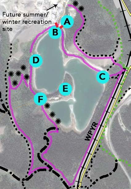
Key Findings and Themes                                 • A majority of survey respondents (67%)
                                                          supported future land use policy that promotes a
                                                          balance between development and
• The future of the RSW area was considered
                                                          protection of green space and aesthetics,
  “important” or “very important” to an
                                                          followed closely by policy promoting minimal
  overwhelming majority of survey
                                                          change (62%). A third policy option to maximize
  respondents.
                                                          development in the area received only 33%
• Views, lack of development, green space,                support.
  and recreational opportunities are the most
                                                        • Recreation was the most supported
  highly valued characteristics of the RSW area by
                                                          future land use option for all of the sub-areas
  survey respondents. The area’s close proximity
                                                          in the RSW corridor. Non-motorized trail use was
  to Downtown was frequently mentioned in
                                                          generally the most supported form of
  relation to the presence of green space, and
                                                          recreational development, but there were many
  many respondents spoke to the area’s gateway
                                                          expressions of support for a new whitewater
  function and role in forming first impressions for
                                                          slalom course, improvements at Ear Lake, and
  visitors to the city.
                                                          motorized trail use.
• Yukon Energy’s liquid natural gas (LNG)
                                                        • Opposition was generally high to future
  plant was the most frequently cited dislike
                                                          built development throughout the RSW area,
  about the study area by survey respondents,
                                                          but there was greater acceptance for
  followed by the “waste” or underutilization
                                                          development in the area immediately south of
  of land, traffic, and quarries/asphalt
                                                          the airport. There was reasonably strong support
  plants. Traffic concerns related to both
                                                          for a continuation of current uses in the snow
  congestion and speeding; some singled out the
                                                          dump/lower bowl area (including the mud bog
  perceived danger of the intersection of RSW with
                                                          and motocross amenities). In contrast, just over
  the Alaska Highway.
                                                          half of respondents expressed opposition to
                                                          continued quarrying and industrial operations in
  Below: Fr eq uent ly occ ur r ing wo rds used t o       the Ear Lake area.
  a nswer the questi on, “ Wha t do you dislike
  a nd/or va lue lea st a bout t he a rea ?”

   8   ROBERT SERVICE WAY PLANNING STUDY FINAL REPORT
4.0 Robert Service Campground Area
for this initiative at present. Additional parking
What We Know would be needed and there is little to no room to
The Robert Service Campground (RSC), Bert Law accommodate it on the river side of RSW.
Park (BLP), and adjacent section of the Millennium
Trail (MT) are situated within the Yukon River Flats W hite ho rse R es iden ts To ld Us:
Wildlife Area, an ecologically rich habitat for birds
and aquatic life. The campground area is an “Great location for a campground close to town.
important heritage site to local First Nations and its Day use area could be…used more for
recreational use by non-Indigenous residents dates community events.”
back to the 1920s. “The campground is managed well but is
The campground is owned by the City but has been outdated and needs improvement as well as
operated on a lease basis for several decades. The expansion.”
campground receives an estimated 19,000-22,000 “It should stay just the way it is!”
visitors to its 68 walk-in tent sites and day use area
“Find biking/hiking Bert Law a little creepy –
during its mid-May to end of September season.
would welcome trail improvements.”
The site is not connected to municipal services and
the washroom building is in need of replacement in “I specifically avoid this campground because of
the short to medium term. City administration the folks ‘living’ there.”
intends to assume operations of the campground in
“Whitewater rec area would be amazing. It has
2018. City staff view the site as an ideal venue for
the potential to be as big as mountain biking in
nature-based programming, including summer
the Yukon.”
camps. Providing overnight sites for small
recreational vehicles (i.e. campers) by expanding The softball diamonds on the west side of RSW
across RSW has also been contemplated. across from the campground access serve about
1100 softball players each spring and summer.
BLP is accessed from the campground and MT via a
About $200,000 of capital improvements have been
bridge and its infrastructure is limited to a few
made to the facility in recent years by Softball
interpretive signs, a bench, and perimeter
Yukon and a 10-year lease with the City for use of
singletrack (narrow) trail. Illegal camping on the
the site was renewed in early 2017.
islands west of the park has been an ongoing issue.
Pedestrian and bicycle connections between the
The Yukon Canoe and Kayak Club (YCKC) aims to
ball diamond and campground, as well as between
construct a whitewater slalom course in the Bert Law
the MT, airport escarpment, and Miles Canyon Road
Island channel through its “Rock the River” project.
(MCR) are marginal.
There is no concrete commitment or timeframe
C y
ROBERT SERVICE WAY PLANNING STUDY FINAL REPORT 9What We Heard
• Survey respondents told us they most frequently • Support was strongest for trail
visited the MT (62% using it “often”). BLP was improvements to BLP (72%) and
visited more frequently than the campground development of a whitewater slalom course
day use area. (65%). Potential campground expansion was
supported by 45% and opposed by 32%.
Planning Directions & • City and/or third party and year-round
programming;
Recommendations • Opportunities for private sector partners;
• Expansion to serve additional visitors and
The long-term planning direction for this portion of (possibly) small recreational vehicles; and,
the RSW area should be the protection and • Accommodating parking for a potential
enhancement of its significant ecological, heritage whitewater slalom course in the future
and recreational values. The 2010 Official within the campground day use area.
Community Plan designation is still
appropriate. Future development should be 2. Complete trail improvements to BLP for
limited to low-impact recreational uses with a improved sustainability and user enjoyment
minimal footprint. In addition, the City should: and promote awareness and
appreciation of the island by incorporating
1. Undertake a facility refurbishment plan to it into City events and programming.
identify service provision, programming
functions, and infrastructure needs for RSC, 3. Install a pedestrian crosswalk between the
with specific consideration for: campground and softball diamonds/RSW bus
stop.
• Showcasing the site’s heritage values and
4. Direct MT and RSC trail users through
traditional uses in cooperation with local
First Nation governments; the campground to bypass a section of RSW
and mark a route from ball diamonds to
• Balancing day and community use with
the escarpment (see Sections 6/9).
visitor needs;
10 ROBERT SERVICE WAY PLANNING STUDY FINAL REPORTPho to above: So uth facing view o f the lower bowl are a from the airpo rt escarpme nt, with lower airport light tower,
the m oto cro ss track and City sno w dump a re a in the cleared are a. Schwatka La ke is visible in the backg ro un d.
5.0 Lower Bowl/Snow Dump
parcel for over 30 years and is interested in a more
What We Know secure tenure and expanding their event offerings.
The motocross track also lacks any motorized multi-
The City’s Lot 1267 and Ta’an Kwäch’än Council’s
use trail connections, although it is regularly used as
(TKC) C-28B currently occupy the C-shaped portion
a staging area for cross-country rides.
of the Yukon River fluvial plain, located in the
middle of the planning area. The site was previously There are several constraints to future development
quarried for gravel and used during the construction of the City’s parcel, including the two ATCO
of the Whitehorse Rapids dam. The area has good distribution lines bisecting it (which currently have
development potential. no easement and would cost about $500-$750,000
to relocate) and the planned installation of an
TKC has no immediate plans to develop their
additional three runway light towers directly west of
parcel. Yukon Energy Corporation (YEC) has
the motocross track. The TKC parcel has an unusual
expressed an interest in the ability to pursue
configuration and access will need to be
potential future energy infrastructure expansion in
coordinated with activities on Lot 1267. Proximity to
this area. The City’s snow dump, which seasonally
the main airport runway largely rules out residential
occupies the southern half of Lot 1267, is the only
development as well.
disposal site available to commercial snow removal
contractors. Any snow dump relocation further from
Downtown could compromise efficiency for the
What We Heard
Public Works department.
• Survey respondents were most supportive of use
Mayor and Council approved a 10-year lease (with of the lower bowl for parks and recreation
3-month termination clause) to the Yukon Cross (play fields, etc.) (82%), community
Country Motorcycle Association in May 2017, agriculture (64%), and continued use for
thereby formalizing a longstanding use of a motocross and “mud bogging” (51%).
motocross track in the northern portion of Lot 1267. Opposition was strongest to built
The Midnight Sun Dirt Riders Association has development.
informally managed a mud bog site in the same
ROBERT SERVICE WAY PLANNING STUDY FINAL REPORT 11• Continued City snow dumping operations
Wh at Wh iteh orse Re side nts T old Us:
received marginal support (42%), but almost
as many neutral responses (38%). There were
“Please don’t pollute this access…with big box
negative comments about site aesthetics.
stores! It sets the…perception of our city.”
• 43% of participants who don’t use the “Motocross, mud bog need a place for their
motocross track expressed support for its events but not (here). Eye sore.”
continued use, while 30% expressed
opposition. “I don’t support destructive machine-based
“recreating”, though I think the motocross
area is a good use and place for that kind of
Planning Directions and thing – a sacrifice zone.”
Recommendations “This is a valuable piece of land close to the
downtown core which is highly under-used.
This area has hosted interim activities for decades, Snow can melt elsewhere.”
and in the absence of a proposal for a specific end
“I think it could be developed into a more
use, a continuation of the status quo is appropriate.
interesting recreational space.”
The 2010 Official Community Plan
designations are still applicable, and the most “Industrial and commercial do not belong
likely trigger for a change to the status quo will be near our river and campground.”
development of the TKC parcel in the future. Over
“Makes sense to use this area as it is already
the long-term, the continuation of snow dumping
disturbed.”
could compromise highest and best use of C-
28B and the land use compatibility provisions of
2. Explore the potential for relocating the snow
TKC’s Self-Government Agreement.
dump to the Ear Lake area over the next 10-15
Over the long-term, the highest and best use of years (see Section 7).
Lot 1267 is deemed to be space-intensive
3. Work with TKC to ensure that future
recreation (playing fields, event grounds, etc.) The
development of C-28B and snow dumping
strategic location of C-28B and TKC’s revenue
operations and lessee activities (if still in
generation interests suggest a broader range of
effect) are coordinated and compatible.
land uses, particularly mixed use and commercial,
could be considered in this parcel. Such 4. Designate and mark motorized multi-use
development would ideally maintain corridor trail connections to and from the
aesthetics to the extent possible. motocross track (see Sections 6/9).
Public support for motorized recreation here is 5. Initiate discussions with Erik Nielsen
considerably higher than it has been in City trail Whitehorse International Airport administration
planning processes in other areas; the continuation around the envisioned new light towers.
of these uses in the future will ultimately depend on
6. Maintain flexibility to support creative,
their compatibility with new uses that emerge.
community-oriented interim uses of the
In addition, the City should: area between RSW and the mud bog site.
1. Initiate discussions with the Midnight Sun Dirt 7. Work with ATCO to establish an easement
Riders Association to formalize use of the for the distribution lines located in Lot 1267.
mud bog site.
12 ROBERT SERVICE WAY PLANNING STUDY FINAL REPORT6.0 Upper Terrace/South of Airport
What We Know Wh at Wh iteh orse Re side nts Said:
This portion of the planning area includes the steep “This area has incredible recreational
glaciolacustrine escarpment found throughout the potential...”
Yukon River valley in Whitehorse, a generally level
“Create an aesthetic corridor leading to
plain in the south, and undulating topography
Whitehorse, first impression shouldn’t be
closer to the airport boundary. The area has good
industrial looking.”
to moderate development potential, although the
escarpment itself is considered highly sensitive. “We already have a large land intensive
commercial area…there is absolutely no
These lands are vacant at present, but the need for more of this.”
Government of Yukon (YG) parcel has been
“This is a prime commercial area, completely
considered for highway operations. Kwanlin Dün
unused. However, development should
First Nation (KDFN) does not have specific plans for
consider aesthetics.”
parcel C-34B at present. The 2020 airport master
plan envisioned mixed commercial-industrial “Creating too much retail or commercial use
development to the airport fence; the plan is next to the highway may slowly replace the
currently being updated. downtown core and become a “1 strip
highway town” (not good).”
Topography and access are the two biggest
constraints on development. In order to meet
• There were many more neutral responses to
highway safety standards, the only probable access
land use options here than for the snow dump
points are from the current Ear Lake Road
area, suggesting that the public may not be as
intersection and across from the weigh scales.
invested in the end use of this site.
Commercial development requiring visibility is
further precluded by the significant grade difference
between the highway and KDFN and YG parcels; Planning Direction and
remedying this would require substantial fill.
Recommendations
The airport perimeter trail is highly used and valued
by Whitehorse residents, but sections of it are The upper terrace area poses an increasingly rare
eroding badly and good connections to/from it are opportunity to develop with minimal negative
limited. impacts on visual quality, environment, or
recreation. Its current zoning as Public Services is
What We Heard appropriate but may be unnecessarily
restrictive. The City should:
• Parks and recreation was the most strongly 1. Consider the re-designation of the
supported option (67%) for future use of this Government of Yukon portion of the upper
area. Development was generally opposed – terrace area to mixed use commercial but
by 46% of respondents for light/clean industrial, retain environmental protection of the
45% for “land-intensive commercial” (car escarpment during the upcoming Official
dealerships, etc.), and 44% for institutional. Community Plan process;
ROBERT SERVICE WAY PLANNING STUDY FINAL REPORT 132. Work with airport administration to address
5. Work with Highways and Public Works to ensure
airport trail erosion and formalize trailhead
that any future controlled intersection at the
signage and parking at the southern
weigh scales includes a pedestrian crossing
boundary;
to facilitate connections to/from Ice Lake Park
3. Designate and mark motorized multi-use (see Section 9); and,
connections between the Alaska Highway, Ear
6. Construct a sustainably graded singletrack
Lake Road and motocross track (see Section 9);
(narrow) trail to/from the escarpment to
4. Maintain minimum 30-metre development crosswalks across from Miles Canyon Road and
buffers from the top of escarpment and retain the Robert Service Campground (see Section 9).
trail connectivity;
14 ROBERT SERVICE WAY PLANNING STUDY FINAL REPORT7.0 Ear Lake Quarries
What We Know What We Heard
Gravel quarrying and industrial activities in the Ear • Non-motorized recreation (85%) and
Lake area began in the 1950s and are currently commercial recreation (63%) were most
confined to two private parcels (owned by Norcon strongly supported as future end uses of the
Enterprises and Skookum Asphalt) and two City ALT lease. Opposition was strongest to
leases (to Norcon and Annie Lake Trucking (ALT)). quarrying (51%) and motorized recreation
(41%).
10-year leases expired in December 2016 and are
now renewed on a month-to-month basis. Planning Direction and
Skookum’s property was a former lease sold by the
City in 2012; the two other lessees are interested in Recommendations
a similar opportunity to purchase. There appears to
In the absence of clear answers on the “big picture”
be non-compliance with lease conditions and there
of citywide gravel supply and availability of suitable
has been little to no coordination around extraction
sites for concrete production, providing a longer-
along the shared boundary of the leases.
term horizon for operators to plan within is prudent.
The operators claim that 10 (ALT) and 20-25 years Maximizing resource extraction in this long
(Norcon) of operating life remain in the pits, but disturbed area has equal merit. However, continued
verification is needed. These two leases support the quarrying activities should not compromise the
territory’s only concrete production at present and potential for highest and best end uses for both the
the combination of clean aggregate and a water lease parcels and Ear Lake.
source are integral. All three stressed the difficulty
Adjacent industrial uses, noise and visuals pose
of finding a comparable site within or close to
limits to future uses of the Norcon lease. In contrast,
Whitehorse that wouldn’t pose other conflicts.
the ALT pit area’s close proximity to Ear Lake and
Questions and concerns about the impact of water visual buffer from the other parcels create unique
withdrawal from Hobo and Ear lakes on water opportunities.
quality and lake levels persist and previous studies
B el ow: Proc e ss an d time li n e t o addre ss
have recommended a hydrological investigation; to
Ear Lake qu arri es
date, this has not been fully implemented.
ROBERT SERVICE WAY PLANNING STUDY FINAL REPORT 15Quarrying is best viewed as a 10-15 year operation requirements and the protection of Ear and
that leverages the shared interests of the City and Hobo lakes.
lessees, answers outstanding questions, and
3. Consider future subdivision of and right of
facilitates the eventual achievement of highest and
first refusal for the western portion of the
best use. Specifically, the City should:
Norcon lease to adjacent owners, subject to
1. Follow a sequential process to support the hydrologeological study and compliance.
orderly extraction and compliance via:
4. Plan for commercial recreation (i.e.
• Third party compliance inspections;
campground) and winter public recreation
• A joint operations and reclamation
as end uses for the ALT lease, and include
plan that includes an updated estimate of
assistance with gates and parking (see Section
remaining granular resources and addresses
8) for Ear Lake as a lease condition for ALT.
shared boundary extraction; and,
• A hydrogeological study funded jointly by 5. As part of the joint reclamation plan, consider
City/lessees to pinpoint water withdrawal and facilitating identified end uses by:
potential impacts, cause(s) for declining lake • Stockpiling silty-clay material (both leases);
levels (and possible mitigation), and • Retaining the pit floor to terrace road (ALT);
maximum pit depth – with 2018 results • Retaining steeper pit faces along the north
incorporated into the joint plan. (Norcon) and northeastern (ALT) boundaries
to allow for blowing of stockpiled snow;
2. Explore the potential for utilizing the entire
• Retaining much of the flat, open area (ALT);
and/or eastern portion of the Norcon lease
and recontouring of western pit faces; and,
for a snow dump and/or waste (i.e. brush)
• Maintaining the visual buffer between ALT’s
disposal site, subject to regulatory
lease and the other developed parcels.
16 ROBERT SERVICE WAY PLANNING STUDY FINAL REPORT8.0 Ear Lake Recreation
What We Know Wh at Wh iteh orse Re side nts Said:
“I would strongly encourage use of this area….
Ear Lake has been used as a recreational area since
so few swimming lakes near Whitehorse.”
the early 1900s, and Robert Service himself mused
about its future as a park in a poem. Ear Lake was “People don’t use Ear Lake anymore because of
once very popular for swimming and picnicking; its rumoured contaminated water… it could be a
over the past 20 or so years, its use has declined lovely..recreation area…but it would need some
considerably. This trend is attributed to frequent development and promotion.”
vandalism and partying at the site, concerns about
“Would spend more time (there) if it had
water pollution, and declining water levels. The site
enhancements – it’s a dirty party place with lots
is used by local companies and clubs for paddling
of garbage.”
instruction, bird watching, and orienteering, but
unstructured uses are predominant. There are no “The area could…ease over-use (elsewhere).”
services at the site presently.
What We Heard Planning Direction and
Recommendations
• Survey participants use the area
“sometimes” (42%) or “rarely” (26%) in Ear Lake is an underutilized asset with great
summer, and “never” or “rarely” (77%) in potential. With nearby quarrying and industrial
winter. Activities included hiking/walking/ activities likely to continue indefinitely, the City
running (64%), swimming (41%), paddling should focus on shifting visitor behaviour at
(32%), bird watching (22%) and orienteering, and perceptions about the site in the interim. The
dirt biking, and snowmobiling (10% each). figure below sets out a step-by-step approach that
will allow the City to make incremental site
• Support for a picnic area and 1-2 marked
interventions, monitor results, and adaptively
loop trails was strong (89% and 92%).
manage the site.
Interpretive signage and an artificial beach
were also popular (73% and 71%).
Abov e: P roc es s an d t ime li ne for Ear Lake re cr eat ion al en ha nc eme n ts
ROBERT SERVICE WAY PLANNING STUDY FINAL REPORT 17Proposed Ear Lake site
enhancements
include:
Vehicle gates –
Installed at the “Y”
intersection and
opened/closed on scheduled basis with ALT assistance.
Parking – 4-5 spaces at gates (next to/on ALT settling pond) for
“after hours” parking; delineated parking at C and D. Safety on
narrow access road into C to be addressed via selective clearing,
pull-outs, wireless traffic control, etc.
Trails and interpretation – New singletrack (narrow) trail built
to create two loop options. A section of the White Pass railway
line would provide optimal route and interpretation. Nearby City
trail could be used as alternate. Trailhead kiosk located at C.
Day use area(s) – Picnic area, change structures, portable
toilet, beach enhancements (with Ear Lake, and native plantings
at the beach and day use area (C) and primary boat launch/group
use site (D).
Ice skating node – Pathway access, signage and benches (B).
Night sky viewing and tenting site – Post quarry reclamation, node E could feature a viewing platform,
shelter, controlled fire pit and seating, picnic area, and tent sites, with associated parking/turn-around at F.
Above: Beach a nd da y use a rea (C ) Above: P r imar y boa t launc h/gr oup use a rea (D)
18 ROBERT SERVICE WAY PLANNING STUDY FINAL REPORT9.0 Trail Connections
What We Know Wh at Wh iteh orse Re side nts Sa id
“…it’s important to legitimize dirt bike use on
The Robert Service Way (RSW) area is home to a some trails to avoid conflicts on other trails.”
wide variety of trails, some of which are among the
“Trail connections in the area are difficult to
most highly used in Whitehorse. The paved
use...if I want to cut up from RSW to the
Millennium Trail (MT) is the city’s most used and
escarpment trail, it’s a very steep, difficult
accessible trail. The airport perimeter trail,
path to push my bike up.”
(essentially a dirt road) is also well used and
showcases some of the best views in the city. “Dirt bikes are disruptive for animals and
people in the area. There is lots of further out
Trail connectivity is compromised throughout the places for dirt bikers.”
area due to the high and steep escarpment, RSW
traffic, Ear Lake industrial activity, and other “People who could consider that area
infrastructure. There are no designated motorized environmentally sensitive will consider every
multi-use (MMU) connections to or from the area environmentally sensitive until there are
motocross track. Dirt bikers utilize the track as a no more places to ride motorized vehicles.”
staging area and connect to trails that run east of
Ear Lake and on to Miles Canyon. Ear Lake is an Planning Direction and
Environmentally Sensitive Area, but the area
between Miles Canyon Road and Ear Lake is a
Recommendations
possible candidate for lower impact motorized trails.
Aside from driving along RSW, trails are the primary
Trail planning for the Ear Lake area is under the way Whitehorse residents experience the planning
purview of the City’s Whitehorse South planning area. While the protection of “destination” trails is
process; there has been no trail planning for RSW. important, the area’s value for cross-city
connections is equally significant. This value will
What We Heard further increase should residential development in
the Southern Urban Containment Boundary area
west of the RSW area occur in the future. The key is
• Survey respondents indicated the connection
to protect, enhance, and efficiently allocate what
between the Miles Canyon Road (MCR)
currently exists and to leverage road corridor and
and MT was the most important (77%),
access improvements that could optimize active
followed by the connection between the
transportation and recreation.
escarpment and Downtown South (72%), airport
perimeter trail (71%), and connection between Motorized use is a divisive issue in Whitehorse, but
escarpment and MT (67%). public response to the idea of MMU trails in the
RSW study area is notably more supportive than
• 45% of respondents supported designating a
that received for such trails in other areas. RSW
MMU trail connection through the Ear Lake
poses an opportunity to site singletrack (narrow)
area and 34% opposed it. Those who didn’t
MMU trails with comparatively little disturbance and
use the motocross track were more divided on
cultivate stewardship and responsible etiquette in a
the issue, with 40% opposing and 36%
user group that has felt marginalized in recent years.
supporting.
To optimize RSW trails, the City should:
ROBERT SERVICE WAY PLANNING STUDY FINAL REPORT 191. Complete trail improvements in Bert Law Park, designate the trail and direct trail users through the campground to connect between the MT and MCR. 2. Install crosswalks across RSW at the campground and MCR “short cut”. 3. Designate MMU trails to/from the motocross track and construct a new MMU singletrack section parallel to Miles Canyon Road to facilitate safer connection. Install maps and educational signage at the track. 4. Designate MMU connections near Ear Lake and consider MMU singletrack designation/development between the RSW area boundary and MCR. 5. Work with airport administration to address erosion of the airport perimeter trail, designate it, establish a formal trailhead and parking area at fence, and build a staircase in Downtown South to create a new connection. 6. Build a sustainably graded singletrack trail to connect the escarpment and RSW crosswalks. 7. Advocate for new Alaska Highway active transportation crossings (at airport south fence, RSW intersection, and Squatter’s Road area) and linear multi-use trail to provide safer connections between local regional parks, residential areas, and the RSW area. 20 ROBERT SERVICE WAY PLANNING STUDY FINAL REPORT
10.0            Other Recommendations

Development Due Diligence
The preceding report focuses primarily on the question of current and future land uses in the Robert Service Way
(RSW) area, and how those uses can be optimized. The Phase 1 Environmental Site Assessment, Heritage
Resources Overview Assessment (HROA), and desktop ecological assessment that were conducted in support of
the RSW planning study provide additional guidance, particularly in the context of site-specific development:

    •   A visual survey of potential contamination concerns should be undertaken in spring/summer/fall,
        focusing on the drain/ditch adjacent to the airport, WPYR railway, former quarrying areas on YG land,
        and the vicinity of the former structures at Ear Lake. Should inspections identify any further evidence of
        potential contamination, a limited soil sampling program could be warranted.

    •   A pedestrian survey, and shovel testing if warranted, is recommended for several hundred discrete areas
        of heritage resource potential lands (about 12.6% of the study area) before any ground disturbing
        activities be approved to proceed. An additional 10 areas (8.7% of the study area) have potential for
        Culturally Modified Trees, and a minimum standard of pedestrian survey is recommended for these.

    •   Avoidance is recommended for the known archaeological sites and the White Pass & Yukon Route
        (WPYR) corridor. Review of the HROA, and field participation of, KDFN and TKC participants is also
        recommended and encouraged before any development is approved to proceed.

    •   Caution should be exercised in design and construction of any enhancements to Ear and Hobo lakes,
        Bert Law Park and Yukon River areas to avoid disruption to bird or fish habitat. This includes limiting trails
        on shorelines and avoiding in-stream works or other causes of erosion and sedimentation.

    •   Avoid development during critical wildlife sensitivity (i.e., nesting season, denning, spawning, etc.)

Other Initiatives to Watch
Other planning and/or development initiatives and opportunities could impact the RSW area and should be
considered during and after the upcoming Official Community Plan update. These include:

   •    Anticipated safety improvements at the RSW-Alaska Highway intersection by Government of Yukon (YG)
        and further north in the airport area. Ideally, transportation planning and improvements would capture
        the myriad of access challenges from the Squatter’s Road area through to Range Road south;

   •    The opportunity for rails-to-trails conversion of the WPYR line from country residential areas to the south
        through RSW area to Downtown. Note that a trolley extension south to Schwatka Lake has been deemed
        largely unfeasible;

    •   The pending Erik Nielsen Whitehorse International Airport 2040 Master Plan; and,

    •   Anticipated YG long-term capital planning that may prompt reconsideration of the upper terrace area for
        a new Whitehorse grader station.

                                                      ROBERT SERVICE WAY PLANNING STUDY FINAL REPORT             21
EDITORIAL NOTE: THIS PAGE IS A PLACEHOLDER FOR AN 11X17 MAP SHOWING ENTIRE PLANNING AREA AND SUMMARIZING RECOMMENDATIONS BY SECTION HEADING WITH PAGE NUMBER REFERENCED. THIS MAP COULD ALSO GO AT THE VERY FRONT. FACING THE TABLE OF CONTENTS PAGE WOULD BE IDEAL FROM LAYOUT STANDPOINT 22 ROBERT SERVICE WAY PLANNING STUDY FINAL REPORT
You can also read