LANDSCAPE-BASED FIRE SCENARIOS AND FIRE TYPES IN THE AYLLÓN MASSIF (CENTRAL MOUNTAIN RANGE, SPAIN), 19TH AND 20TH CENTURIES1
←
→
Page content transcription
If your browser does not render page correctly, please read the page content below
Cuadernos de Investigación Geográfica
                                                      2020   Nº 46 (1)    pp. 103-126      eISSN 1697-9540
Geographical Research Letters
DOI: http://doi.org/10.18172/cig.3796                                              © Universidad de La Rioja

   LANDSCAPE-BASED FIRE SCENARIOS AND FIRE TYPES
   IN THE AYLLÓN MASSIF (CENTRAL MOUNTAIN RANGE,
            SPAIN), 19TH AND 20TH CENTURIES1

                                   C.R. SEQUEIRA1*, C. MONTIEL-MOLINA1, F.C. REGO2

                                                  1
                                                   Department of Geography, Faculty of Geography and History,
                                                                    Complutense University of Madrid, Spain.

                                      2
                                          Centro de Ecologia Aplicada Prof. Baeta Neves, School of Agriculture,
                                                                                University of Lisbon, Portugal.

        ABSTRACT. Wildfires have been a major landscape disturbance factor throughout
        history in inland mountain areas of Spain. This paper aims to understand the
        interaction of fire regimes and landscape dynamics during the last two centuries
        within a socio-spatial context. The study area selected for this historical and
        spatial analysis is the Ayllón massif, in the Central Mountain Range. The
        theoretical background used to identify the driving forces of fire regime changes
        over the 19th and 20th centuries in this mountain area includes landscape-based
        fire scenarios and fire-type concepts. Both concepts have been addressed in recent
        studies from a spatial planning and fire management approach in an attempt to
        understand current fire landscapes and wildfire risk. However, this is the first time
        that these concepts have been applied to show that both spatial and temporal
        scales are crucial for an understanding of the current wildfire panorama, and
        that fire history related to landscape dynamics is fundamental in socio-spatial
        differences in fire regimes.

        Four variables (fire history, land use, population and settlement system, and forest
        management) were assessed to define historical landscape-based fire scenarios,
        and three fire feature variables (fire extent, fire cause, and spatial distribution
        pattern) were considered to define historical fire-types. We found that the non-
        linear evolution of fire regimes during the 19th and 20th centuries was determined
        by fire-type changes according to landscape dynamics. Moreover, population and
        forest management have been the main driving forces of fire regime tipping points

     1 This paper has received the First Prize and Honorable Mention from the Young
Researcher Innovation Award on Mountain Areas, granted by the Research Group on Physical
Geography in High Mountains, Complutense University of Madrid (Department of Geography),
Spain.

Cuadernos de Investigación Geográfica 46 (1), 2020, pp. 103-126                                           103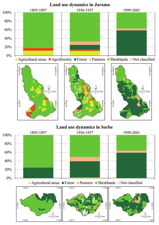
Sequeira et al.

         or pyrotransitions. This study validates the hypothesis that fire regime changes
         are the result of the interaction of fire history and landscape dynamics.

         Escenarios territoriales del fuego e incendios-tipo en el macizo de Ayllón
         (Sistema Central, España), siglos XIX y XX
         RESUMEN. Los incendios forestales han sido históricamente uno de los princi-
         pales factores de trasformación del paisaje en las regiones montañosas del inte-
         rior de España. El objetivo de este artículo es explicar la interacción que se ha
         establecido a lo largo de los últimos dos siglos entre el régimen de incendios y las
         dinámicas del paisaje, en su contexto territorial. El área de estudio seleccionada
         para llevar a cabo este estudio ha sido el Macizo de Ayllón, en el Sistema Central.
         Los escenarios territoriales del fuego y los incendios-tipo son los dos conceptos
         básicos del marco teórico empleado para identificar las fuerzas motrices de los
         cambios del régimen de incendios acontecidos durante los siglos XIX y XX en
         esta región montañosa. Ambos conceptos han sido recientemente manejados en
         la investigación sobre ordenación del territorio y gestión del fuego para expli-
         car los paisajes y el riesgo de incendios. Sin embargo, es la primera vez que se
         aplican para demostrar la influencia de las escalas espacial y temporal en la
         definición del problema de los incendios forestales y para poner de manifiesto
         que la dialéctica histórica fuego-paisaje es fundamental para comprender las
         diferencias socio-espaciales del régimen de incendios en la actualidad. La va-
         loración histórica de los escenarios territoriales del fuego se ha apoyado en el
         análisis de cuatro variables (historia del fuego, uso del suelo, población y sistema
         de poblamiento, y gestión forestal), y para la identificación de los incendios-ti-
         po históricos se han manejado tres de sus principales características (superficie
         quemada, causa del siniestro y distribución espacial de los incendios). El resulta-
         do obtenido ha mostrado una evolución discontinua del régimen de incendios a lo
         largo de los siglos XIX y XX, como consecuencia de los cambios acontecidos en
         los incendios-tipo en relación con las dinámicas del paisaje. Además, la pobla-
         ción y la gestión forestal han sido las principales fuerzas motrices de los puntos
         de ruptura en el régimen de incendios, denominados pirotransiciones. En defini-
         tiva, esta investigación ha permitido validar la hipótesis de trabajo que atribuía
         los cambios del régimen de incendios a la interacción de la historia del fuego y
         las dinámicas del paisaje.

         Key words: fire regime, historical wildfires, land use, Spain, pyrogeography.
         Palabras clave: régimen de incendios, incendios históricos, uso del suelo,
         España, pirogeografía.

                                                                            Received: 30 October 2018
                                                                            Accepted: 24 January 2019

104                                      Cuadernos de Investigación Geográfica 46 (1), 2020, pp. 103-126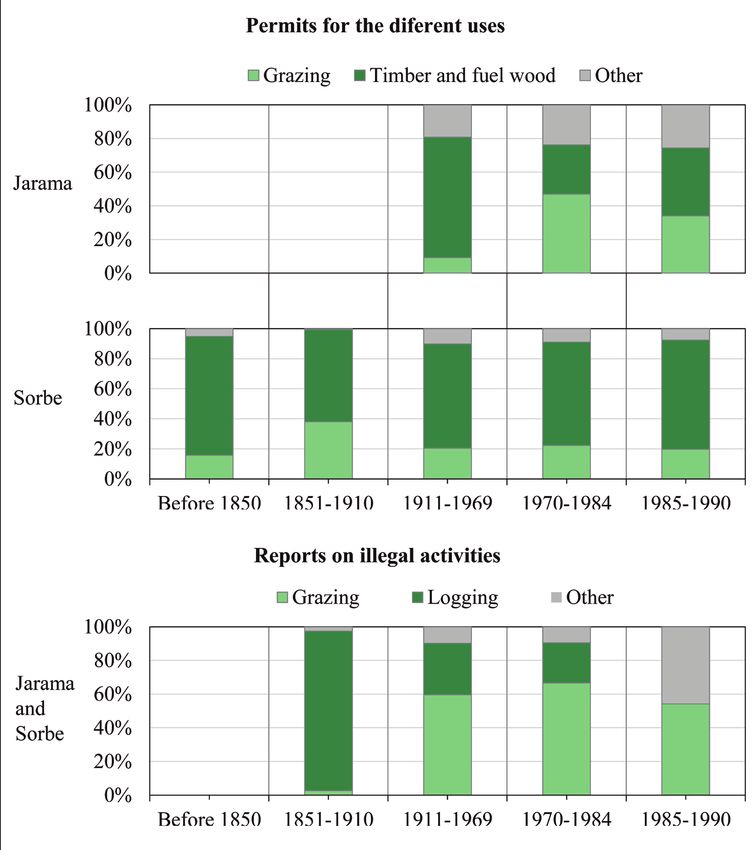
Landscape-based fire scenarios and fire types

*Corresponding author: Catarina Romão Sequeira, Forest Geography, Policy and
Socioeconomics Research Group, Department of Geography, Complutense University
of Madrid, 28040 Madrid, Spain. E-mail address: anacatte@ucm.es

1. Introduction

      Humans and fire have evolved with each other, and in their regular interaction fire
has become a risk factor for human society (Pyne, 1997; Scott, 2018). Mediterranean-
type climate landscapes are highly fire-prone (Keeley et al., 2012; Pausas et al., 2008).
Especially from the 1980s onwards, fire risk has become a complex and challenging
topic for policy-makers, land managers and operational systems (European Commission,
2017; San-Miguel-Ayanz et al., 2017; Turco et al., 2016). New planning and prevention
approaches have been introduced into the research agenda, aimed at predicting fire
behavior, thus providing basic information for its control and management (Cissel et al.,
1999; Coughlan et al., 2012, 2013; Duane et al., 2015; O’Connor et al., 2011; Silva et al.,
2010). These new fire management approaches include concepts such as fire-type and
landscape-based fire scenarios (Black et al., 2005; Castellnou et al., 2010, 2009; Costa
et al., 2011; LaCroix et al., 2006; Murphy et al., 2013; Pérez et al., 1998), formulated in
pyrogeography, which attempts to examine the human-fire relationship from an holistic
perspective (Bowman, 2015; Keeley et al., 2011; Roos et al., 2014).
      The fire-type concept refers to fire spread patterns depending on the fuel load,
landscape structures and synoptic weather conditions (Acebrón, 2017; Costa et al.,
2011). On the other hand, landscape-based fire scenarios refer to the contextual factors
of a fire regime, i.e. the environmental, socioeconomic and policy drivers of wildfire
ignition and propagation on different spatial and temporal scales. In fact, fire scenarios
are multiscale land-type planning units for a fire regime with different applications at
national, regional, and local scales. Previous studies have addressed landscape-based
fire scenarios in Spain at a national scale (Montiel-Molina et al., 2016) and a regional
scale (Costa et al., 2011). Nevertheless, the local scale has not attracted the attention
of many researchers, despite proof of its importance when examining the relationship
between fire regime and landscape dynamics (Beilin et al., 2015; Wilbanks et al.,
1999). Moreover, the vast majority of recent studies have focused on a recent time scale
context (since 1968, when fire data statistics started), regardless of the fact that fire and
landscape history are relevant to the current fire risk (Smith et al., 2016) and that a longer
perspective is needed to characterize fire regime changes. Even though no specific data
on fire behavior is available before the statistical period (which makes it difficult to apply
the fire-type method), fires recorded pre-1968 do share two common features: extent and
fire cause (Montiel-Molina, 2013), applicable to the definition of the historical fire-type
concept.
     The concepts of both landscape-based fire scenario and of fire-type therefore
provide a theoretical basis to explain the dynamic character of the fire regime, through
spatial and temporal dimensions (Keeley et al., 2012). Fire regime changes can be
either linear or progressive, or non-linear based on tipping points, i.e. pyrotransitions,
which in Mediterranean landscapes are closely related to anthropic aspects (Tedim et

Cuadernos de Investigación Geográfica 46 (1), 2020, pp. 103-126                                           105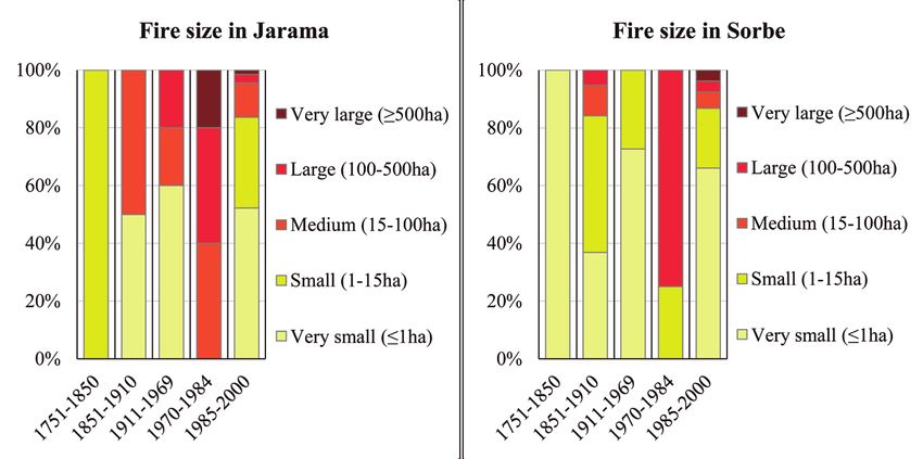
Sequeira et al.
al., 2014). In general, fire regimes are linked to the environmental, socioeconomic and
political contextual systems, which differ from place to place. When there is a balance
between the contextual systems, the fire regime is expected to display linear progress.
However, when there is an imbalance between these influencing systems, or a change in
one of them, the fire regime changes abruptly, triggering a pyrotransition (Bowman et al.,
2011). In this context, the concepts of fire scenario and fire-type enable the identification
of pyrotransitions and an understanding of the fire regime dynamics (Krebs et al., 2010).
The reconstruction of fire regimes, at a local scale and from a historical perspective,
should consider some key components such as fire history, and others related to an
understanding of the driving forces of fire behavior, such as land use, population and
settlement system, and forest management. Recent studies have approached Spanish fire
history before statistical data was available, from century time scales and based on geo-
historical sources analysis (Araque, 1999; Lloret et al., 2001; Montiel-Molina, 2013), to
millennial time scales through palynological and paleoecological methods (Abel-Schaad
et al., 2013; Franco-Múgica et al., 2001; Gil García, 1992; Ruiz Zapata et al., 1996;
Vera et al., 1984). Other studies confirm the connection between land use changes, fire
behavior and landscape structure (Viedma et al., 2006). However, because long historical
land use data series are unavailable, most studies of land use changes are restricted to the
second half of the 20th century (Gallardo et al., 2016; Martínez-Vega et al., 2017; Viedma
et al., 2015).
This paper connects landscape-based fire scenario (LFS) and fire-type (FT) concepts
from a long-term perspective (19th and 20th centuries) at a local scale in the Ayllón massif,
well-known for its particular historical dynamics related to fire (Montiel-Molina, 2013).
We believe that the fire regime in Ayllón Massif is non-linear, with three pyrotransitions:
(1) at the end of the 19th century; (2) in the 1970s; and (3) in the mid-1980s, facilitated
by a breakdown in the balance of contextual factors. This led us to formulate our
hypothesis, which proposes that the fire regime changed according to the fire scenarios,
fire history and fire types, and that tracing the history of these key values will allow us to
describe the fire regimes that existed in each phase between pyrotransitions. This paper
attempts to answer the question of what driving forces were responsible for fire regime
pyrotransitions throughout the 19th and 20th centuries in the Ayllón Massif.
2. Material and Methods
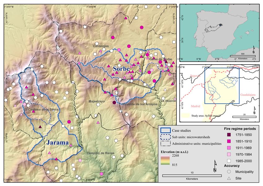
2.1. Study area
This case study was carried out in the Ayllón Massif, which covers 1400 km2 in
the eastern part of the Central Mountain Range natural region in the Iberian Peninsula,
between the provinces of Guadalajara, Segovia and Madrid (Castel, 1873; Mata Olmo et
al., 2004). Slopes are steep, and altitudes range from 700 to 2272 m a.s.l. The climate is
predominantly sub-Mediterranean with mean annual temperature around 8ºC and mean
annual precipitation from 800 mm to over 1500 mm (FAO Climate data). The vegetation
is very diverse, given its significant climatic variety. The most important species are
Pinus sylvestris, Quercus pyrenaica, Quercus coccifera, Fagus sylvatica, and Nardus
106 Cuadernos de Investigación Geográfica 46 (1), 2020, pp. 103-126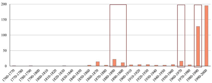
Landscape-based fire scenarios and fire types

stricta (high mountain pastures) (Mecha-López, 2004). Two headwaters (Jarama and
Sorbe) in the Tagus River water catchment area are located in the Guadalajara area of
the massif, where the predominant lithology is metamorphic (black slate and gneiss),
sedimentary (clay slate), and igneous (granite) (Blazquez-Díaz, 1987). The Ayllón massif
is a protected National Park (Natura 2000 Network, “Sierra Norte de Guadalajara”
Natural Park, since 2011), Special Protection Area for birds, and Special Conservation
Area. Most of this forest area is publicly owned and is regulated and protected as Forest
for Public Use. These forest areas were common land until the end of the 19th century.
      Two case study areas were selected and delimited using micro-watershed units
within the Ayllón massif: (1) Sorbe and (2) Jarama (Fig.1). Both case studies consist
of four micro-watersheds and cover a total area ranging from 8000 to 10,000 ha. The
Jarama case study area is in the heart of the massif and covers the municipal districts of
Campillo de Ranas and El Cardoso de la Sierra. The Sorbe area covers three municipal
districts on the eastern side of the massif (Cantalojas, Galve de Sorbe and La Huerce)
plus two districts in the heart of the massif (Majaelrayo, and Valverde de los Arroyos).
All these municipal areas were considered as the spatial reference for data collection,
processing and analysis.
     The study area is characterized by marked human influence through natural resource
management of timber, charcoal and firewood supplies, and because of the extensive
afforestation campaigns in the 19th and 20th centuries (Fernández-Muñoz, 2002; Lopéz-

      Figure 1. Study area, case studies and spatio-temporal distribution of fire occurrence.

Cuadernos de Investigación Geográfica 46 (1), 2020, pp. 103-126                                           107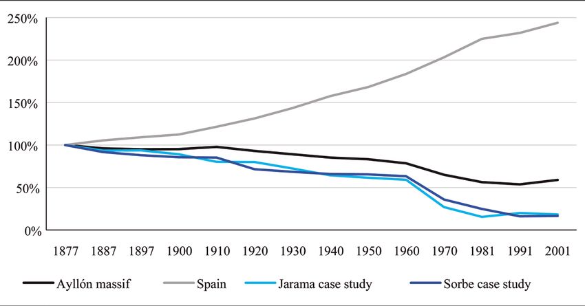
Sequeira et al.

Gómez, 1974). Logging, grazing and hunting were historically the main activities in
this forest area, with the origin of some settlements related to hunting practices (e.g. El
Cardoso de la Sierra) or to livestock (with constructions known as tainas in e.g. Valverde
de los Arroyos and Majaelrayo). Nowadays, the cultural landscape of the Ayllón is
severely depopulated or with an aging population, where tourism has become the main
economic resource for the isolated villages (Agnoletti et al., 2015).

2.2. Data: sources and variables

     The characterization of landscape-based fire scenarios is based here on four main
spatial components: (i) land use; (ii) population and settlement systems; (iii) forest
management; (iv) fire history. These spatial components are analyzed in a historical
and dynamic approach, according to the availability of sources and our focus on the
processes (Table 1).

                              Table 1. Sources and data used for each variable.

                                                                              Data
    Variables         Sources
                                               Name                 Dates      Format         Scale       Retrieved from
                                                                                                             Instituto
                                         Planimetric map          1895-1897     Raster      1:25,000        Geográfico
                                            collection                                                       Nacional
                  Geohistorical and
                    cartographic                                                                        Map Services of the
    Land use                                                                                            Gobierno Regional
                                             Ortophoto            1956-1957     Raster      1:32,000      de Castilla-La
                                                                                                             Mancha
                                      Corine Land Cover Map                                             Copernicus Land
                     Geospatial                                   1999-2001     Vector      1:100,000
                                               2000                                                     Monitoring Service
                                                                               Average                   Instituto Nacional
                                        Population Census         1864-2001   interval 10   Municipal
  Population                                                                                               de Estadística
                                                                                 years
 and settlement      Statistical
    systems                                                                    Average
                                      Nomenclator Municipal                                              Instituto Nacional
                                                                  1858-2000   interval 10   Municipal
                                            Registry                                                       de Estadística
                                                                                 years
                                                                                                         Instituto Nacional
                     Statistical        Agriculture Census          1999                    Municipal      de Estadística
    Forest
  management                           Minutes of Municipal
                  Historical Docu-    council meetings, Auc-      1750-1990     Paper       Municipal   Municipal Archives
                      mentary         tions papers and others
                                                                                                        Forest, Geography,
                                                                                                            Policy and
                   Based on histor-                                                          Central
                                       Fire history Database                                             Socioeconomics
                  ical documentary                                Pre-1980s    Access       Mountain
                                               (FHD)                                                     Research Group,
  Fire history          sources                                                              System       Complutense
                                                                                                            University

                                      Statistical Fire Database                                         Spanish Ministry of
                     Statistical                                  From 1968    Access        Spain
                                               (EGIF)                                                      Agriculture

     Land use changes were considered in order to understand the fuel structure from the
late 19th century to the year 2000. The main sources and data used for this assessment
were geohistorical cartographic sources (Planimetric map collection 1895-1897, in
raster format, scale 1:25,000, available from the Instituto Geográfico Nacional (IGN);
Ortophoto 1956-1957, in raster format, scale 1:32,000, provided by the Map Services

108                                                    Cuadernos de Investigación Geográfica 46 (1), 2020, pp. 103-126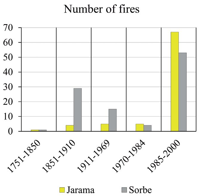
Landscape-based fire scenarios and fire types

of the Gobierno Regional de Castilla-La Mancha) and geospatial data sources (Corine
Land Cover Map 2000, 1999-2001, in vector format, scale 1:100,000 with minimum
cartographic unit 25 ha, available from Copernicus Land Monitoring Service).
      Population and settlement systems were assessed to describe the human influence on
the landscape. This was done through the following statistical data sources: Population
Census 1864-2001, average interval 10 years, at municipal level for all 7 municipal
districts covered by the case studies (available from Instituto Nacional de Estadistica
(INE); and Nomenclator Municipal Registry 1858-2000, average interval 10 years, at
municipal level for all 7 municipal districts (also available from INE).
     The forest management component was considered to evaluate the socioeconomic
value of land management and the influence of rural activities on fuel control in the case
study area, using official statistical data (Agriculture Census 1999 at municipal level)
and municipal historical documentary data sources.
      The fire history was evaluated using the same resources as those used for analyzing
historical fire types, based on three fire variables (fire extent, fire cause, and spatial
distribution pattern, including the Fire History Database (FHD) and statistical fire database
(Estadística General de Incendios Forestales, EGIF). Both are Access databases sharing
data to define each fire event (date, geo-location accuracy, extent, cause, etc.), but each
one refers to a different period and is based on different information sources. The FHD,
created by the Forest Geography, Policy and Socioeconomics Research Group in the
Complutense University of Madrid, refers to the pre-1980s and is based on documentary
sources (administrative documents, judicial and police sources and the press) obtained
from different types of archives (historical archives, forest services and municipal archives
and historical libraries). We gathered 101 historical fire records from 1768 to 1982 in the
Ayllón massif study area, including 15 records for the Jarama and 46 records for the Sorbe
area. All these historical fire records were geo-referenced with different levels of accuracy
(from municipal boundaries to specific sites or plots) depending on the precision of the
historical source. The EGIF is the official fire dataset provided by the Spanish Ministry
of Agriculture since 1968 with increasing data accuracy over time (Vélez Muñoz, 2009).
We used this statistical information to update the FHD until 1982, and then considered the
EGIF for a second analytical period from 1983 to 2000, which includes 323 fire records
(67 records for the Jarama and 56 records for the Sorbe case study).

2.3. Methods and techniques

      Spatial and historical methods were used to integrate and analyze very diverse
data series. Territorial and fire dynamics were investigated in a systemic approach,
using ArcGIS for Desktop 10.3 to process the data (including photo interpretation), and
qualitative analysis and basic statistical analysis techniques (Microsoft Excel 2013) for
data integration. These methods were applied to process selected components to define
fire scenarios (land use, population and settlement system, and forest management) and
the variables considered to define fire types (fire extent, fire cause, and fire distribution
pattern).

Cuadernos de Investigación Geográfica 46 (1), 2020, pp. 103-126                                           109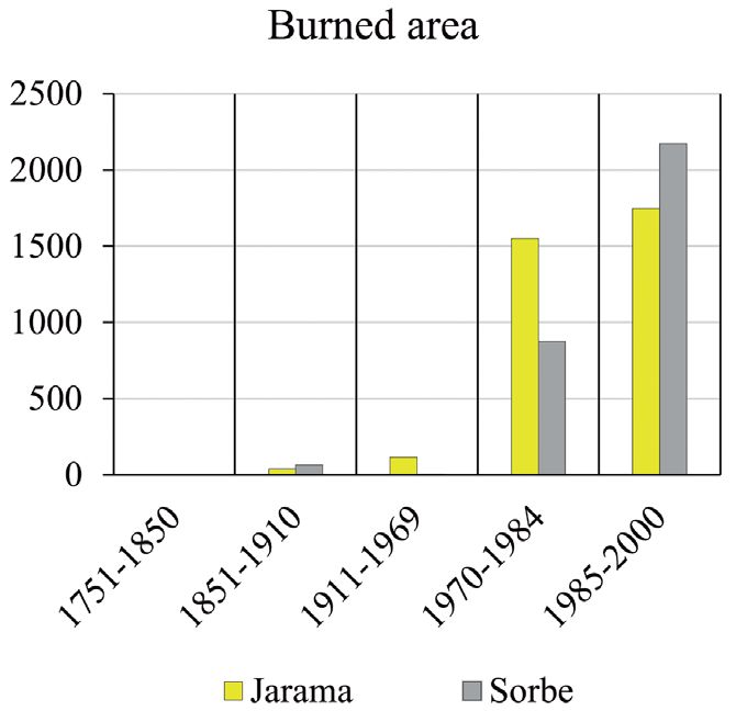
Sequeira et al.

     We used two spatial analysis scales: a landscape or intermediate scale (1:25,000) for
the whole Ayllón massif study area (Smith et al., 2016); and a local scale (1:10,000) to
approach the Jarama and Sorbe case studies (Beilin et al., 2015). For the temporal scale,
we used a long-term analysis (19th and 20th centuries) to identify the tipping-points of fire
regime change and the related driving factors.

3. Results and Discussion

3.1. Fire history and fire-types

     Reconstructing fire history from geo-historical documentary sources shows that fire
has been an ever-present feature since at least the late 18th century in the Ayllón massif,
and particularly in the Jarama and Sorbe watersheds. 101 fire records from 1768 to 1982
were obtained for this mountain area, often related to rural activities where fire was a
common land management tool (Table 2). This was why there are so many pre-1880 fire
records, of small forest fires reflected in the printed press, judicial and police sources
because of their social and economic impact. This human impact at a local scale explains
why some wildfires are recorded in several documentary sources despite the relatively
small area burned.

                  Table 2. Number of fire records for each period and fire database

                                      FHD (1768-1982)                    EGIF (1983-2000)
 Ayllón massif                                 101                                 323
 Jarama case study                              15                                  67
 Sorbe case study                               46                                  56
 *FHD: Fire History Database; EGIF: Statistical Fire Database

     The first large wildfire was recorded on August 15, 1891 in the public forests in
Riaza (Segovia) with three simultaneous ignitions, burning 119 ha. Other large wildfires
were recorded in 1954, 1970, 1978 and 1983. Since 1991 – when three large wildfires
were recorded – this type of fire situation, the increasing number of ignitions and the
variability of fire behavior have defined the present fire regime of uncertainty in the
Ayllón massif.
      According to the fire history of this massif, three shifts or pyrotransitions have
been identified in the fire regime dynamics in the 19th and 20th centuries (Fig. 2). These
fire regime shifts occurred especially (i) in the late 19th century/early 20th century, with
increased fire occurrence; (ii) in the 1970s, when a few fires caused a large burnt area;
(iii) in the 1980s, when fire occurrence increased again, leading to a new uncertainty
scenario. In short, from the late 19th century until the year 2000, there was a shift in the
Ayllón from a situation where fire was used as a management tool in everyday rural
activities to one where the fire risk is unexpected and uncontrolled.

110                                         Cuadernos de Investigación Geográfica 46 (1), 2020, pp. 103-126
Landscape-based fire scenarios and fire types
Figure 2. Number of fires recorded in the Ayllón massif and tipping-points (or pyrotransitions) of
the fire regime dynamics (rectangles).
The drivers leading to the present fire regime have historical roots at the local level.
In fact, significant differences were found between the two local case studies. The Jarama
area was historically less affected by wildfires than the Sorbe watershed, although the
opposite was true during the statistical period (see Table 2 and Fig. 3a). Nevertheless, the
evolution of the burnt area has been different in both areas and is greater in Sorbe than
in Jarama since 1984 (Fig. 3b).
Figure 3a. Occurrence of fires in Jarama and Figure 3b. Extent of fires in Jarama and Sorbe.
Sorbe.
Historical fire types were analyzed during the five periods identified according
to the three pyrotransitions mentioned above and the tipping-point recognized by the
mid-19th century resulting from the socioeconomic effects of Forest Administration
regulations in the context of Liberalism. Thus, fire types have been characterized
in each period according to their main features, i.e. fire size, fire cause, and spatial
Cuadernos de Investigación Geográfica 46 (1), 2020, pp. 103-126 111Sequeira et al.
distribution pattern. Fire size is classified as follows: (i) very small fire, < 1 ha; (ii) small
fire, 1-15 ha; (iii) medium size fire, 15-100 ha; (iv) large fire, 100-500 ha; (v) very large
fire, > 500 ha. These numerical thresholds were established from a thorough analysis of
historical events, considering that a small historical fire usually represents an accident,
i.e. loss of control in the use of fire, and is extinguished by efficient community-based
suppression systems. In contrast, what are usually called large historical fires in the
documentary sources are normally larger than 100 ha and demonstrate the inefficiency
of local suppression systems.
On a local scale, the first very large wildfire (>500 ha) is recorded in the 1970s in
the Jarama watershed, and ten years later in Sorbe (Fig. 4). In both cases, the ignition
trends and burnt areas, and the occurrence of very large wildfires, suggest that the last
pyrotransition is marked by a large wildfire episode resulting from the destabilization of
the entire socio-spatial system. This destabilization occurred later – although with more
abrupt effects – in the Sorbe watershed as a result of landscape dynamics related to the
fire use practices maintained until the second pyrotransition in the 1970s. However, very
large wildfires remain exceptional events in the Ayllón massif due to the rural character
of the landscape and the socio-economic dynamics. Currently, small and very small fires
are the main sizes observed in this mountain area.
Figure 4. Fire size in Jarama and Sorbe.
For the direct causes of fire, four major ignition groups have been identified in
the Ayllón massif: (i) burning for pasture renewal/agriculture/forest activities, (ii)
intentional/arson, (iii) natural/lightning, and (iv) negligence/accidental/other. It was
found that for this variable, the two case studies were historically fairly similar (Fig. 5).
Despite the limitations of the historical documentary sources, the available data show
that burning for pasture renewal/agriculture/forest activities and negligence/accidental/
other were the two main causal factors of fire in the Ayllón massif until 1984. Since
then, intentional/arson fires are the most prevalent, particularly in the Jarama watershed,
112 Cuadernos de Investigación Geográfica 46 (1), 2020, pp. 103-126Landscape-based fire scenarios and fire types
due to the breakdown of the traditional land management system and the introduction
of new lifestyles which increased fires from arson in the late 20th century. Also notable
is the high proportion of fires from natural causes here at the eastern end of the Central
Mountain Range (Vélez Muñoz, 2009).
Figure 5. Fire causes in Jarama and Sorbe.
For the spatial location pattern, historical fires were geo-referenced according to the
information recorded at two levels of accuracy: (a) municipality, and (b) plot/site. The
municipal level includes historical fire records where documentary sources do not provide
information about the precise ignition site, and pre-2000 statistical records without
geographic coordinates. Plot/site refers to historical fire records with spatial information
about the fire ignition and the statistical records since 2000 with geographic coordinates.
Despite these constraints, the space-time analysis of the location of historical fires at
local level obtains a concentrated pattern of fire records over time in Sorbe, meaning a
fire resilient landscape (San-Miguel-Ayanz et al., 2017) in comparison with the relatively
random pattern and fire deficit in Jarama (Fig. 1).
3.2. Population dynamics and settlement system
The cultural landscape of the Ayllón massif is linked to the demographic dynamics,
population lifestyle and rural practices. This mountain area located in the Spanish central
region of Castilla benefitted only barely from the legislative progress in civil affairs during
the period of the Second Republic, which just brought about a slower rate of population
decline since the first census (1877) in contrast with the general positive trend in the country
as a whole (Fig. 6). The social and cultural stagnation lasted until the 1960s during the
Franco dictatorship (Ussel, 1990). Then, the economic development and cultural changes
in Spain linked to the industrialization process and urban growth led to the rural exodus and
abandoning of agrarian activities in mountain areas in the interior (Jerez et al., 2004). This is
particularly evident in Sorbe and Jarama, where the decline in population and rural activities
Cuadernos de Investigación Geográfica 46 (1), 2020, pp. 103-126 113Sequeira et al.
Figure 6. Relative demographic evolution of Spain, Ayllón massif, Jarama and Sorbe case
studies.
continued until the recovery in the 1980s in Jarama and in the 1990s in Sorbe, due to official
local development policies co-funded by the European Union (Montiel-Molina, 2003).
As a result of this long secular decline in the Ayllón massif (from 20,539 inhabitants
in 1877 to 15,154 in 2001), the population density in 2001 was lower than four inhabitants
per km2, which is considered by FAO as a severe under-population problem. In fact, the
Ayllón massif is one of the mountain areas in central Spain included in the European
high-risk fire scenarios of disadvantaged rural areas (Montiel et al., 2010).
Table 3. Population and settlement system dynamics.
Population density of the settlement system (Inhab/km²)
Case study Jarama Sorbe
Year 1900 2000 1900 2000
Small villages 2.37 0.34 6.84 1.54
Scattered populated areas 0.08 0.09 0.01 0.01
3.3. Land use changes
The present forested landscape characterizing both Sorbe and Jarama is the result of
similar land-use dynamics throughout the 20th century, re-shaping the very different cultural
landscape in each watershed at the end of the 19th century. Although shrublands were the
predominant land-use in both areas 1895-1897, Jarama had a significant agricultural area,
mainly in the central and southern sectors, while Sorbe was entirely woodland. However,
by 1999-2001 both Sorbe and Jarama had a very similar forested landscape, with approx.
58% forest, 5% pasture and the remaining area shrubland (Fig. 7).
114 Cuadernos de Investigación Geográfica 46 (1), 2020, pp. 103-126Landscape-based fire scenarios and fire types
Figure 7. Land use dynamics in Sorbe through the 19th and 20th centuries (1895-1897, 1956-
1957 and 1999-2001) in Jarama and in Sorbe case studies.
Cuadernos de Investigación Geográfica 46 (1), 2020, pp. 103-126 115Sequeira et al.
Forest land use had increased considerably in the Ayllon Massif by the end of the
20th century. However, the dynamics of the land use change were completely different
in the first and in the second half of the century. In the first fifty years a growing trend
to forest regression and general maintaining of other land uses can be observed in both
Jarama and Sorbe, while the most striking trend since the 1950s is the general forest
progression. With these contrasting dynamics, the formerly diverse landscape structures
have become increasingly uniform and unstable, particularly in Jarama (Fig. 8).
Figure 8. Land use changes in Sorbe and in Jarama in (1895-1897) − (1956-1957) and (1956-
1957) − (1999-2001).
The main factors influencing these contrasting dynamics of land use change and
the related landscape uniformity and instability are the official polices of expropriation
(19th century) and reforestation (20th century) (Fernández-Muñoz, 2002; Fernández-
Muñoz et al., 2000). The Common Agricultural Policy (CAP) Reform measures have
also contributed to recent forest progression through afforestation programs (Vadell et
al., 2016). In addition, the abandonment of rural mountain areas in inland Spain in the
1960s resulted in the loss of traditional land management practices and the generally
uncontrolled progression of woodland (Stellmes et al., 2013; Tolón Becerra et al., 2007).
3.4. Forest resources management and regulation
Historically, forest management played a major role in the socioeconomic
organization of rural areas in the Ayllón massif. The large number of local regulations
and related permits, and reports on illegal activities, are a good indicator of the critical
value of forest resources for the subsistence economy in both Jarama and Sorbe. Timber
and firewood extraction were the main forest products in both areas, while communal
grazing was also a widespread forest management practice, mainly with transhumance
from Extremadura and Andalucía (Blanco, 1993; Comíns et al., 2011) (Fig. 9).
Grazing was a widespread forest management practice in the rural areas of the
Central Mountain Range, and livestock density remained relatively stable in the Ayllón
massif until the mid-20th century (Lopéz-Gómez, 1974). However, certain variations can
116 Cuadernos de Investigación Geográfica 46 (1), 2020, pp. 103-126Landscape-based fire scenarios and fire types
Figure 9. Social indicators of forest resources management until 1990.
be seen at the local scale. In Sorbe, livestock density increased during the period 1911-
1970, mainly due to an open-range livestock grazing trend in the 1930s and 40s for meat
production. Then, in the 1970s, the traditionally predominant sheep and goats almost
disappeared, in contrast with a sustained or even increased trend to cattle rearing in
Jarama (Fig. 10).
Reports on illegal forest uses mostly relate to grazing activities since 1911 and
refer to conflicts between local inhabitants because of a shortage of pastureland. The
subsequent period (1970-1984) highlights that conflictive situation further, largely due
Cuadernos de Investigación Geográfica 46 (1), 2020, pp. 103-126 117Sequeira et al.
Figure 10. Average livestock density (number of livestock per hectare) in Sorbe and Jarama.
to the implementation of EU afforestation programs. We suggest that grazing activities
in the Ayllón massif retained their social non-economic value, but because they were not
organized on a consensual basis, they generated regulatory problems and illegal grazing
activities. The last period (1985-1990) evidences some degree of chaos, since the number
of reports on illegal forest uses other than logging and grazing increased sharply. On the
other hand, most illegal logging conflicts seem to have been solved in the Ayllón massif
in this last period analyzed (Fig. 9).
Other contextual factors of local conflicts related to forest resource management
are the consequences of the expropriation process in the 19th century. The subsequent
municipal management system and legal protection of forest for public use led to
many different systems of community-based management regulations in Sorbe and
Jarama (Montejano, 1988), originating an increasing number of reports of illegal uses
of the forest (Fig. 9). In fact, the province of Guadalajara is one of the areas which
best represents the expropriation process in the latter half of the 16th century, leading at
that time to the start of the demographic decline, livestock recession, deforestation, and
the socio-spatial reorganization of agricultural areas. Nevertheless, these privatization
processes of forestland were not significant in the Sorbe and Jarama rural areas (Gómez-
Mendoza, 1967). On the contrary, new land management regulations introduced by
the Forest Administration in the second half of the 19th century, and hydrological and
forestry policies in the 20th century, disrupted the land ownership structure and socio-
spatial systems in the area.
Following the mid-20th century transition of rural society, the forest resource
management system was not adapted to the new socioeconomic situation (Paniagua et
al., 2001). The trend to an aging population and decreasing active population continued,
despite the new opportunities emerging from local development policies (Delgado Viñas,
2015; Pascual, 2006). Furthermore, this mountain area lost its importance as the main
118 Cuadernos de Investigación Geográfica 46 (1), 2020, pp. 103-126Landscape-based fire scenarios and fire types
supplier of forest products to Madrid and further isolated itself by accentuating traditional
economic rural activities and forest uses, mainly in Sorbe (Hernando et al., 2016).
3.5. Shaping the landscape-based fire scenarios
Both the fire regime and territorial dynamics have changed throughout the history
of the Ayllón massif, which explains the presence of different fire risk situations and
territorial fire scenarios. As multiscale land-type planning units, the current landscape-
based fire scenarios at the national scale are the massifs and forestry ranges of the
Central Mountain Range and mountain massifs and ranges, southwestern peneplains,
characterized by scarcely-populated, predominantly forested areas with high/medium
propagation capacity and low agricultural presence (Montiel-Molina et al., 2016). At
the regional scale, the Sorbe and Jarama watersheds are both within the forestland use
scenarios of first and second wildfire generations. The first wildfire generation scenarios
refer to long perimeters and high propagation velocity fire behavior due to the continuity
of the forest mass as a result of agricultural abandonment. The second wildfire generation
scenarios imply complex, high intensity wildfires with high propagation velocity because
of increased fuel load from the abandoning over time of farmland and traditional forest
management (Costa et al., 2011; Montiel-Molina et al., 2018).
The Ayllón massif is a mountainous area in the interior of the Iberian Peninsula
characterized by its isolation from the main road networks, reduced croplands and scarce
population dependent on small-scale domestic agriculture and livestock activities,
mainly open-range beef cattle rearing (Allende et al., 2014; Paniagua et al., 2001).
However, fire risk is more dependent on socio-ecological conditions at the local scale,
than on the socio-spatial character at the regional scale. Our data shows that the Jarama
watershed comprises the most underpopulated municipality of the Ayllón massif and it
is characterized historically by a lower occurrence of wildfires. On the other hand, the
Sorbe area is less suitable for agriculture, with more forest resources and a higher impact
of historical wildfires.
The four variables selected to define the historical landscape-based fire scenarios
– fire history, land use, population and settlement system, and forest management – can
be qualitatively ranked in order of importance for the shaping of current fire scenarios.
The two most influential variables are land use and forest resources management and
regulation. The other two variables – population and settlement, and fire history – play
a secondary supporting role, enhancing the dynamics generated by the two leading
variables. We argue that no single fire scenario can be defined for each local case study
since there is insufficient data available on historical fire behavior, but instead the
dynamics of each variable can be reconstructed to analyze their interactions (Table 4).
In short, we have identified three different spatial-temporal fire scenarios in the
Ayllón massif since the late 19th century:
The socio-ecological context in the period between the two pyrotransitions identified
(from the end of the 19th century to the 1970s), characterized by overall forest regression
dynamics, decreasing population and livestock density, and increasing fire occurrence.
Cuadernos de Investigación Geográfica 46 (1), 2020, pp. 103-126 119Sequeira et al.
Table 4. Fire scenarios variables.
Variables and case studies 80s
End of the > 70s > 20th >
Pyrotransitions 19th century 20th century century 2000
Fire history Increase on the nr
Jarama and Increase on
Increase on the number of fires of fires
Sorbe burned area Uncertainty
Land use Jarama and Sorbe Forest regression Forest progression
80s: Decrease
Jarama Increase
Decrease on population on popu-
on pop-
Population and lation
ulation
settlement 90s:
Sorbe Increase
Decrease on population on popu-
lation
Livestock amount decrease and changes on composition
Jarama
Illegal
Main forest resource exploitation: Timber and fuel wood logging
Forest man- Social conflict situation for forest resources conflict
agement solved
Sorbe
40s: Live-
Livestock stock amount Livestock amount decrease
amount decrease increase
Jarama
case study: Sorbe case study:
Size Occurs first Occurs first very
very large large fire
fire
Fire types
Cause Main fire cause:
Main fire cause: Burning for pastures various
Distribution Jarama case study: Random
pattern Sorbe case study: Concentrated
This was a still a relatively stable fire scenario, because despite the increasing number
of fires and conflicts related to the grazing practices in communal areas, the main causes
of wildfires were still connected with traditional rural activities in Sorbe and in Jarama.
1. The contextual factors of wildfires from the second to the third pyrotransition
(1980s) linked to major land use change that led to widespread forest
progression and a significant increase in the burnt area. In this fire scenario, the
agricultural character of the Jarama area was lost, the equilibrium of the socio-
ecological system was disrupted, and the first very large fire was recorded.
Forest and shrublands spread while the management of forest resources was
abandoned. In addition, changes in population structure seem to have altered
the socio-ecological system, especially in Jarama where depopulation was even
more pronounced. Moreover, the processes of agricultural industrialization,
rural exodus, land abandonment, change in traditional rural practices, and
energy transition from the use of biomass to fossil fuels, caused landscape
homogenization, generally favoring wildfire occurrence in the last decades of
the 20th century.
120 Cuadernos de Investigación Geográfica 46 (1), 2020, pp. 103-126Landscape-based fire scenarios and fire types
2. From the third pyrotransition onwards, the occurrence of fire events increased
sharply in a context of growing uncertainty. The causes of fires changed as
a result of the shifting social system, and the socio-ecological equilibrium of
Sorbe was lost, ten years later than Jarama. Local conflicts related to grazing
activities and lack of governance mechanisms for conflict resolution led to a
scenario of very high fire risk, depending on extreme meteorological situations
in the Ayllón massif (Pausas et al., 2012; San-Miguel-Ayanz et al., 2017).
5. Conclusions
The interactions between landscape dynamics and fire regime do not display linear
progressions in time or space in the Ayllón massif. The rural fire culture, prevalent for
centuries, meant that fire was commonly used as a land management tool in this rural
context (i.e. frequent but controlled use of fire for the maintenance of pastureland).
At historical moments of socio-ecological crisis and system instability (e.g. the
establishment of the forest administration in the 19th century or the rural abandonment
in the 20th century), the frequency of fire occurrence and the burnt area increased. In
the Ayllón massif, the influence of the socio-ecological system on the fire regime was
evidenced through the pyrotransitions identified in the late 19th century, in the 1970s,
and in the mid-1980s.
Reconstruction of the fire history and analysis of key socio-spatial variables of
landscape dynamics in the 19th and 20th centuries have enabled us to describe the space-
time context of wildfires at a local scale and to demonstrate the influence of historical
landscape dynamics as the driving forces of the present fire scenarios in Sorbe and
Jarama.
The main driving forces shifting fire regimes and shaping fire scenarios in the
Ayllón massif during the 19th and 20th centuries were forest resource management and
land use changes. These same drivers and processes took place in all Mediterranean
countries to different degrees (Millington et al., 2007), and were significantly shaped
by human societies throughout history, closely related to fire use practices, particularly
for agriculture and grazing purposes (Keeley et al., 2012; Mazzoleni et al., 2004; Silva
et al., 2010). This means that in all Mediterranean countries the same set of socio-
spatial variables considered in our study are drivers of landscape change, and the spatial
differences of fire types are mainly related to contrasting timelines and to specific
local conditions (Beilin et al., 2015). Thus, the strong connection between past socio-
ecological dynamics and current landscape structures is a convincing argument in favor
of the major role of history in our understanding of current scenarios and fire regimes
(Smith et al., 2016).
Acknowledgements
This study is part of the PhD Thesis developed by C. Sequeira under the supervision
of C. Montiel and F. Rego. This PhD has been funded by the Spanish Science Ministry
(BES-2014-068696) and is being conducted within the Spanish National Research
Cuadernos de Investigación Geográfica 46 (1), 2020, pp. 103-126 121Sequeira et al.
Project FIRESCAPE (CSO2013-44144-P) in the Research Group of Forest Geography,
Policy and Socioeconomics at the Complutense University of Madrid.
References
Abel-Schaad, D., López-Sáez, J.A. 2013. Vegetation changes in relation to fire history and human
activities at the Peña Negra mire (Bejar Range, Iberian Central Mountain System, Spain)
during the past 4,000 years. Vegetation History and Archaeobotany 22 (3), 199-214. https://
doi.org/10.1007/s00334-012-0368-9.
Acebrón, M.L.G. 2017. Tipificación de los incendios forestales en la provincia de Guadalajara
(Castilla-La Mancha). Foresta – Asociación y Colegio Oficial de Ingenieros Técnicos
Forestales 67, 32-39.
Agnoletti, M., Santoro, A. 2015. Cultural values and sustainable forest management: the case of
Europe. Journal of Forest Research 20 (5), 438-444. https://doi.org/10.1007/s10310-015-
0500-7.
Allende, F., López, N. 2014. Las Sierras del norte de Guadalajara: de los comunes de villa y tierra
al paisaje de las repoblaciones forestales. In: F. Molinero Hernando (Coord.). Atlas de los
paisajes agrarios de España. Ministerio de Agricultura, Alimentación y Medio Ambiente,
Madrid, pp. 879-884.
Araque, E. (Coord.). 1999. Incendios históricos. Una aproximación multi-disciplinar. Universidad
Internacional de Andalucía, Baeza. 422 pp.
Beilin, R., Reid, K. 2015. It’s not a ‘thing’ but a ‘place’: reconceptualising ‘assets’ in the context
of fire risk landscapes. International Journal of Wildland Fire 24 (1), 130-137. https://doi.
org/10.1071/WF14935.
Black, A.E., Opperman, T. 2005. Fire Effects Planning Framework: user’s Guide. General
Technical Report GTR-RMRS– 163WWW. USDA, Forest Service, Rocky Mountain
Research Station. 63 pp.
Blanco, D.R. 1993. Ganados y señores en la Extremadura medieval. In: S.R. Becerra (Ed.).
Simposio Trashumancia y Cultura Pastoril en Extremadura. Asamblea de Extremadura,
Mérida, 376 pp.
Blazquez-Díaz, A. 1987. Estudio geomorfológico del valle de Majaelrayo (Sierra de Ayllón,
Guadalajara). Eria. Revista de Geografia 12, 43-60.
Bowman, D.M.J.S. 2015. What is the relevance of pyrogeography to the anthropocene?
Anthropocene Review, 2 (1), 73-76. https://doi.org/10.1177/2053019614547742.
Bowman, D.M.J.S., Balch, J., Artaxo, P., Bond, W.J., Cochrane, M.A., D’Antonio, C. M., Swetnam,
T.W. 2011. The human dimension of fire regimes on Earth. Journal of Biogeography 38 (12),
2223-2236. http://doi.org/10.1111/j.1365- 2699.2011.02595.x.
Castel, C. 1873. Noticias físico-naturales de la sección NO de la Provincia de Guadalajara. Revista
Forestal T. VII, 216-225 and 254-257.
Castellnou, M., Larrañaga, A., Miralles, M., Vilalta, O., Molina, D. 2010. Wildfire scenarios:
Learning from experience. In: J.S. Silva, F. Rego, P. Fernandes, E. Rigolot (Eds.). Towards
Integrated Fire Management – Outcomes of the European Project Fire Paradox. European
Forest Institute, Finland, 228 pp.
Castellnou, M., Miralles, M., Molina, D. 2009. Patrones de propagación de incendios forestales y
su uso para la planificación. In: R. Vélez Muñoz (Ed.). Incendios Forestales: Fundamentos y
Aplicaciones. McGraw-Hill, pp. 274-282.
Cissel, J.H., Swanson, F.J., Weisberg, P.J. 1999. Landscape management using historical fire
regimes: Blue River, Oregon. Ecological Applications 9 (4), 1217-1231.
122 Cuadernos de Investigación Geográfica 46 (1), 2020, pp. 103-126Landscape-based fire scenarios and fire types
Comíns, J.S., Moreno, D.R. 2011. Atlas de los paisajes de la provincia de Guadalajara. Servicio
de publicaciones Universidad de Alcalá, Alcalá de Henares.
Costa, P., Castellnou, M., Larrañaga, A., Miralles, M., Kraus, D. 2011. Prevention of Large
Wildfires using the fire types concept. UT GRAF-Generalitat de Catalunya, Barcelona, 87 pp.
Coughlan, M. R., Petty, A. M. 2012. Linking humans and fire: A proposal for a transdisciplinary
fire ecology. International Journal of Wildland Fire 21(5), 477-487. https://doi.org/10.1071/
WF11048.
Coughlan, M.R., Petty, A.M. 2013. Fire as a dimension of historical ecology: A response to
Bowman et al. (2011). Journal of Biogeography 40 (5), 1010-1012..https://doi.org/10.1111/
j.1365-2699.2012.02767.x
Delgado Viñas, C. 2015. Agrarian dynamics and landscape in rural mountain areas of Spain.
Journal of Settlements and Spatial Planning 4, 145-154.
Duane, A., Piqué, M., Castellnou, M., Duane, A. 2015. Predictive modelling of fire occurrences
from different fire spread patterns in Mediterranean landscapes. International Journal of
Wildland Fire 24 (3), 407-418..https://doi.org/10.1071/WF14040
European Commission. 2017. Forest Fires in Europe, Middle East and North Africa 2016 –
Scientific and Technical Research Series. JRC Technical Reports. Publications Office of the
European Union, Luxembourg. https://doi.org/10.2760/17690.
Fernández-Muñoz, S. 2002. Consecuencias socioeconómicas y territoriales de las repoblaciones
forestales en el Alto Sorbe (Guadalajara). Eria 58, 183-203.
Fernández-Muñoz, S., Mata Olmo, R. 2000. Pasado y presente de las repoblaciones forestales en
montes de sociedades de vecinos. Estudios Geográficos 240, 461-486.
Gallardo, M., Gómez, I., Vilar, L., Martínez-Vega, J., Martín, M. P. 2016. Impacts of future land
use/land cover on wildfire occurrence in the Madrid region (Spain). Regional Environmental
Change 16 (4), 1047-1061. https://doi.org/10.1007/s10113-015-0819-9.
Gil García, M.J. 1992. Dinámica de la paleovegetación en el sector oriental del Sistema Central
Español durante el Holoceno, en base al análisis polínico. Implicaciones climáticas. PhD
Thesis, Universidad de Alcalá.
Gómez-Mendoza, J. 1967. La venta de baldios y comunales en el siglo XVI. Estudio de su proceso
en Guadalajara. Estudios Geográficos 109, 499-559.
Hernández Vera, T., Ruiz Zapata, B. 1984. Datos preliminares de los análisis polínicos de las
tollas ubicadas en Galve de Sorbe (Guadalajara). Anales de la Asociación de Palinólogos de
Lengua Española 1, 71-76.
Hernando, J., Madrazo, G. 2016. Firewood and charcoal consumption in Madrid during eighteenth
century and its effects on forest landscapes. In: E. Vaz, C. Joanaz de Melo, L.M. Costa Pinto
(Eds.). Environmental history in the making. Environmental History, 6. Springer International
Publishing, pp. 321-340. https://doi.org/10.1007/978-3-319-41085-2_18.
Jerez, D.P., Fernández-Such, F., Martín, B O., Llanes, Ó.M. 2004. Las zonas rurales en España: Un
diagnostico desde la perspectiva de las desigualdades territoriales y los cambios sociales y
económicos. Caritas Española, Madrid.
Keeley, J.E. 2011. Fire in Mediterranean ecosystems. Israel Journal of Ecology & Evolution 58,
123-135. https://doi.org/10.1017/CBO9781139033091.
Keeley, J.E., Bond, W.J., Bradstockd, R.A., Pausas, J.G., Rundel, P.W. 2012. Fire in the
Mediterranean Ecosystems – Ecology, Evolution and Management. Cambridge University
Press, Cambridge.
Krebs, P., Pezzatti, G.B., Mazzoleni, S., Talbot, L.M., Conedera, M. 2010. Fire regime: history
and definition of a key concept in disturbance ecology. Theory in Biosciences 129 (1), 53-69.
https://doi.org/10.1007/s12064-010-0082-z.
Cuadernos de Investigación Geográfica 46 (1), 2020, pp. 103-126 123Sequeira et al.
LaCroix, J.J., Ryu, S.R., Zheng, D., Chen, J. 2006. Simulating fire spread with landscape
management scenarios. Forest Science 52 (5), 522-529.
Lloret, F., Marí, G. 2001. A comparison of the medieval and the current fire regimes in managed
pine forests of Catalonia (NE Spain). Forest Ecology and Management 141 (3), 155-163.
https://doi.org/10.1016/S0378-1127(00)00323-6.
Lopéz-Gómez, A. 1974. Colectivismo y sistemas agrarios de la Serranía de Atienza (Guadalajara).
Estudios Geográficos 35, 137-519.
Martínez-Vega, J., Díaz, A., Nava, J.M., Gallardo, M., Echavarría, P. 2017. Assessing land use-
cover changes and modelling change scenarios in two mountain Spanish national parks.
Environments 4 (4), 79. https://doi.org/10.3390/environments4040079.
Mata Olmo, R., Sanz Herráiz, C.S. (Eds.) 2004. Atlas de los Paisajes de España. Centro de
Publicaciones Ministerio de Medio Ambiente, Madrid.
Mazzoleni, S., di Pasquale, G., Mulligan, M., di Martino, P., Rego, F. 2004. Recent dynamics of the
Mediterranean Vegetation and Landscape. Wiley.
Mecha-López, P. 2004. Modelizacion territorial aplicada a la gestiónfForestal en la vertiente
sur de la Sierra de Ayllón. PhD Thesis. Escuela Técnica Superior de Ingenieros de Montes.,
Universidad Politécnica de Madrid.
Millington, J.D.A., Perry, G.L.W., Romero-Calcerrada, R. 2007. Regression techniques for
examining land use/cover change: A case study of a Mediterranean landscape. Ecosystems
10 (4), 562-578. https://doi.org/10.1007/s10021-007-90204.
Montejano, N.G. 1988. Apuntes en torno a la organización comunitaria de la Comarca de Ayllón
(Segovia). Anales del Museo del Pueblo Español. Dirección General de Bellas Artes y Bienes
Culturales, Segovia, pp. 171-178.
Montiel-Molina, C. 2003. Tradición, renovación e innovación en los usos y aprovechamientos en
las áreas rurales de montañas. Cuadernos Geográficos 33, 7-26.
Montiel-Molina, C. 2013. Presencia histórica del fuego en el territorio. Ministerio de Agricultura
y Pesca Alimentación y Medio Ambiente (MAPAMA), Madrid.
Montiel-Molina, C., Galiana-Martín, L. 2016. Fire scenarios in Spain: a territorial approach to
proactive fire management in the context of global change. Forests 7 (273), 1-17. https://doi.
org/10.3390/f7110273.
Montiel-Molina, C., Karlsson-Martín, O., Galiana-Martín, L. 2018. Regional fire scenarios in
Spain: Linking landscape dynamics and fire regime for wildfire risk management (in revision).
Journal of Environmental Management 233, 427-439. https://doi.org/10.3390/f7110273.
Montiel, C., Herrero, G. 2010. Overview of policies and practices related to fire ignitions. In: J.
Sande Silva, F. Rego, P. Fernandes, E. Rigolot (Eds.), Towards Integrated Fire Management–
Outcomes of the European Project Fire Paradox.European Forest Institute, Joensuu, pp. 35-
46.
Murphy, B.P., Bradstock, R.A., Boer, M.M., Carter, J., Cary, G.J., Cochrane, M.A., Bowman,
D.M.J.S. 2013. Fire regimes of Australia: A pyrogeographic model system. Journal of
Biogeography 40 (6), 1048-1058. https://doi.org/10.111/jbi.12065.
O’Connor, C.D., Garfin, G.M., Falk, D.A., Swetnam, T.W. 2011. Human Pyrogeography: A New
Synergy of Fire, Climate and People is Reshaping Ecosystems across the Globe. Geography
Compass 5 (6), 329-350. https://doi.org/10.1111/j.1749-8198.2011.00428.x.
Ollero, H.S., Juaristi, C.M., Maldonado Ruiz, J., García Antón, M., Múgica, F. 2001. Evolución
de la vegetación en el sector septentrional del macizo de Ayllón (Sistema Central). Análisis
polínico de la turbera de Pelagallinas. Anales Del Jardín Botánico de Madrid 59 (1), 113-124.
Hoggart, K., Paniagua, A. 2001. The restructuring of rural Spain? Journal of Rural Studies 17(1),
63-80. https://doi.org/10.1016/S0743-0167(00)00037-1.
124 Cuadernos de Investigación Geográfica 46 (1), 2020, pp. 103-126You can also read