Milton Keynes Council Plan:MK Schedule of Proposed Main Modifications February 2019
←
→
Page content transcription
If your browser does not render page correctly, please read the page content below
Plan:MK Schedule of Proposed Main Modifications

                                              Milton Keynes Council

                                                    Plan:MK

Schedule of Proposed Main Modifications

                                                  February 2019

                                                        1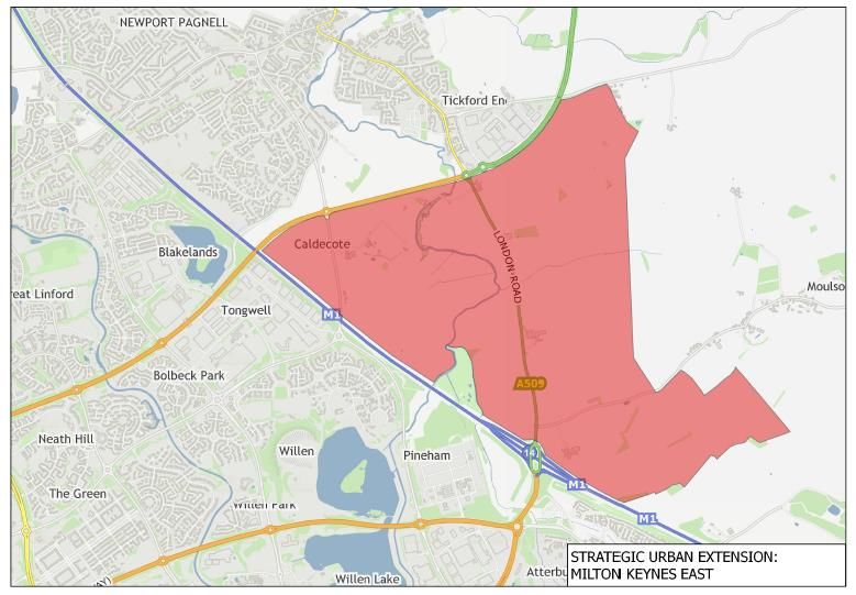
Plan:MK Schedule of Proposed Main Modifications

Ref        Pg No     Policy    Para/Table/   Proposed modification
                               Figure/Bullet Deletions
                                             Additions

MM1        12        MK1                         Delete policy.

MM2        13                  Para 4.6          Delete Paragraph 4.6 and replace with new section entitled “Review of Plan:MK” with text to read as follows:

                                                 Review of Plan:MK

                                                 As outlined in the strategic objectives of Plan:MK, Milton Keynes Council is committed to realising the city’s potential as the hub of the
                                                 Cambridge-Milton Keynes-Oxford growth corridor, responding positively to the aspirations of the Council’s MK Futures 2050 programme,
                                                 the Council Plan 2016-2020 and the NIC report ‘Partnering for Prosperity’, to expand the City to a population of approximately 500,000
                                                 people by 2050.

                                                 It is recognised that to achieve this transformational level of growth, a coordinated, strategic approach which involves joint working with
                                                 neighbouring authorities will be required. To this end, Milton Keynes Council is already undertaking a joint Strategic Growth Study in
                                                 partnership with Aylesbury Vale District Council and South Northamptonshire Council to assess how transformational growth can be
                                                 delivered in this area, alongside the provision of local and strategic infrastructure and mechanisms to support delivery.

                                                 Once completed, the study will inform the preparation of Milton Keynes Council’s Strategy for 2050 which will provide a framework for how
                                                 the aspirational levels of growth supported by the Council should be delivered, to be translated into future reviews of the Local Plan. This
                                                 study may also form the basis for a potential cross-boundary, joint strategic plan on a wider geography.

                                                 Given the ongoing nature of this work and the need for clarity on a range of issues, including the delivery of national infrastructure
                                                 projects and discussions with Government around potential housing and/or new settlement deals in the growth corridor, it was considered
                                                 premature for Plan:MK to formalise these growth aspirations.

                                                 Milton Keynes Council is therefore committing, as outlined in Policy DS0, to an early review of Plan:MK, with the intention that a draft plan
                                                 containing strategic policies will be submitted to Government for examination no later than the end of 2022. Determined through ongoing
                                                 discussions with neighbouring authorities and government, this may take the form of a joint strategic plan.

                                                 The commitment to the timing of the review reflects the Council’s acknowledgement that upon adoption, Plan:MK will have a plan period of
                                                 12 years to 2031 and although it allocates sites for well above its OAN for housing, it does not set a housing requirement that reflects the
                                                 long-term aspiration for transformational growth.

                                                 A deadline of 2022 will therefore enable the Council to adopt its Strategy for 2050 (envisaged for completion in 2019), allow the plan review
                                                 to reflect decisions on key infrastructure projects such as the routing of the proposed Cambridge to Oxford expressway, and allow time for
                                                 the review to take full account of, and be prepared in the context of, the emerging growth agenda across the corridor.

                                                                                                   2
Plan:MK Schedule of Proposed Main Modifications
MM3 13 Para 4.5 Insert new Policy after new text as outlined in MM2, to read as follows:
Policy DS0
Review of Plan:MK
The Council commits to undertaking an early review of Plan:MK, with the submission of a draft plan for examination, containing strategic
policies for the long-term growth of Milton Keynes, no later than December 2022.
Following the completion of the joint Strategic Growth Study and adoption of the Council’s Strategy for 2050 in 2019, the review of
Plan:MK will bring the delivery of the long-term aspirations for transformational growth into a statutory planning policy document.
The parameters and format of the review will also reflect Milton Keynes’ growth proposals within the context of a potential Growth Deal as
well as progress on the delivery of the Government’s wider Cambridge – Milton Keynes – Oxford Corridor growth agenda, including
associated national infrastructure projects and a corridor-wide Joint Vision Statement anticipated in Spring 2019.
The review will also develop and formalise, as appropriate, joint working arrangements with neighbouring authorities which may result in
the preparation of a joint strategic plan on a wider geography.
MM4 16 Paras 4.20 – Delete Paragraphs 4.20 – 4.22 and replace with:
4.22
Land east of the M1: Plan:MK allocates land to the east of the M1 motorway, south of Newport Pagnell, for a mixed residential and
employment strategic urban extension to meet the long term needs of Milton Keynes. The development of this site is dependent on the
necessary strategic infrastructure, required to make the site deliverable before 2031, being funded and delivered up-front.
If the necessary infrastructure can be funded and delivered prior to 2031, then the development will be allowed to proceed within the plan
period. In that circumstance, the number of dwellings that the site can contribute towards the housing supply of Plan:MK will be
dependent upon when development commences. For the purposes of Plan:MK’s housing supply a conservative total of 1,475 dwellings of
the potential 3,000 is assumed to be deliverable within the plan period and accounted for in the trajectory. This may increase to around
3,000 dwellings in the plan period if early infrastructure funding is secured, within a total site capacity of some 5,000 dwellings, including
delivery beyond the plan period.
There may be further potential for growth in this direction beyond that envisaged in this allocation, but realising the full potential of this
area would require cross-boundary agreement with Central Bedfordshire Council and further improvements to connectivity between any
future allocations east of the M1 and the existing city. These will be considerations for the review of Plan:MK.
MM5 16 DS1 Insert new paragraph immediately above Table 4.2 as follows:
The provision of new homes and jobs will take account of the settlement hierarchy set out in table 4.2. The majority of development will be
focused on and adjacent to, the existing urban area of Milton Keynes at the locations specified in table 4.2 and from selective infill,
brownfield, regeneration and redevelopment opportunities. Within the rural area of the Borough most new development will be
concentrated within the key settlements of Newport Pagnell, Olney and Woburn Sands. Elsewhere within the rural area new development
will occur within villages and other rural settlements at locations identified in made neighbourhood plans.
3Plan:MK Schedule of Proposed Main Modifications
MM6 18 Policy Plan:MK will deliver a minimum of 26,500 net dwellings across the Borough of Milton
DS2 Keynes over the period 2016-2031. New housing development will be focused on, and adjacent to, the existing urban area of Milton Keynes, as well
as the three key settlements, and will be delivered by:
1. The completion of existing city estates, expansion areas and strategic land allocations
2. The continued development of Central Milton Keynes including the Campbell Park residential area development areas
3. The completion of existing commitments as outlined in Appendix A
4. “South East Growth Area South East Milton Keynes Strategic Urban Extension: The development of a new comprehensive
residential-led strategic allocation on the edge of the existing urban area, extending the development boundary of the urban area to potentially
incorporate approximately 3,000 dwellings. This development will only come forward once progress has been made on the delivery of
East-West Rail and, furthermore, will only be brought forward once the route of the proposed Oxford to Cambridge Expressway is
agreed and its land requirements confirmedbe delivered as set out in Policy SD13
5. Land at Eaton Leys: residential development of up to 600 homes, with associated facilities
6. The delivery of sites already identified in made Neighbourhood Plans, both within the urban and rural area of the Borough
7. The development of small to medium sized, non-strategic sites, within the urban area of Milton Keynes, as allocated through Plan:MK, as
outlined below. in Appendix A - Housing Sites within this plan
8. Small to medium scale development within rural and key settlements, appropriate to the size, function and role of each settlement to be
delivered through allocations in neighbourhood plans currently being prepared.
9. The regeneration of some existing city housing estates as brought forward by the Your:MK Council’s regeneration programme, subject to
local referendums
10. Regeneration opportunities around the centres of Wolverton and Bletchley
11. The redevelopment of brownfield sites, vacant or underused sites within the Milton Keynes urban area will be encouraged where such
development is in line with other relevant policies in this plan, including design, density, access and connectivity
12. Land East of the M1: a mixed residential and employment strategic site to the east of the M1, south of Newport Pagnell, is designated as
a reserve site to come forward post 2031 allocated as a strategic urban extension to meet the long term needs of Milton Keynes.
Development of this site may be permitted can commence prior to once 2031 should the Council be successful in obtaining
Government funding to enable delivery of necessary infrastructure, the necessary strategic infrastructure required to make the site
deliverable, including required connections to the existing urban area of Milton Keynes, is funded and is being delivered prior to any
development taking place.
13. Permitting development proposals within the defined settlement boundaries where they comply with all other relevant policies of Plan:MK
and neighbourhood plans.
As part of the wider requirement for housing strategy, the provision of additional housing accommodation for older persons and those
with specialist needs through bed spaces within residential institutions (Use Class C2) will be supported. The forecast provision over the
plan period in the Strategic Housing Market Assessment 2017 is some 1200 bedspaces and delivery against this projection will be
monitored. Policy HN3 of the Plan will inform specific development proposals.
As per Criterion 7 above, the following small to medium, non-strategic sites, as outlined on the Policies Maps, are allocated for residential
development:
4Plan:MK Schedule of Proposed Main Modifications
Site Reference Area Site Approximate No. of
Dwellings
HS1 BLETCHLEY FORMER MFI BUILDING 28
HS2 BLETCHLEY BERWICK DRIVE 16
HS3 BLETCHLEY CHEPSTOW DRIVE 11
HS4 CALDECOTTE CALDECOTTE SITE C 67
HS5 CAMPBELL PARK CAMPBELL PARK 1,500
NORTHSIDE
HS6 CAMPBELL PARK F4.4 51
HS7 CAMPBELL PARK G4.1 141
HS8 CAMPBELL PARK G4.2 202
HS9 CAMPBELL PARK G4.3 166
HS10 CAMPBELL PARK LAND NORTH OF GLEBE 60
ROUNDABOUT,
OVERGATE
HS11 CENTRAL MILTON C3.2 135
KEYNES
HS12 CENTRAL MILTON C3.3 113
KEYNES
HS13 CENTRAL MILTON WYEVALE GARDEN 280
KEYNES CENTRE
HS14 CENTRAL MILTON R/O CENTRAL LIBRARY 98
KEYNES
HS15 CENTRAL MILTON R/O SAXON COURT 85
KEYNES
HS16 CENTRAL MILTON R/O WESTMINSTER 63
KEYNES HOUSE
HS17 CENTRAL MILTON C4.2 93
KEYNES
HS18 CENTRAL MILTON D3.4 250
KEYNES
HS19 CENTRAL MILTON FOOD CENTRE 298
KEYNES
HS20 FISHERMEAD KELLAN DRIVE 1 10
HS21 FULLERS SLADE CAVENDISH SITE 37
HS22 GREENLEYS FORMER MILTON KEYNES 125
RUGBY CLUB
HS23 LAKES ESTATE SOUTHERN WINDEMERE 11
DRIVE
HS24 MEDBOURNE S OF VERNIER CRESCENT 18
HS25 MONKSTON LINDISFARNE DRIVE 20
HS26 MONKSTON WADHURST DRIVE 17
HS27 OLD FARM PARK BYRD CRESCENT 25
HS28 REDHOUSE PARK THE WALNUTS 125
HS29 SPRINGFIELD SPRINGFIELD 15
BOULEVARD 1
HS30 STANTONBURY REDBRIDGE 19
HS31 STANTONBURY ROWLE CLOSE 18
HS32 STONY STRATFORD HIGH STREET (FORMER 24
GAS WORKS SITE)
HS33 TATTENHOE HOWE ROCK PLACE 17
HS34 TATTENHOE WINFOLD LANE 24
HS35 TATTENHOE HOLBORN CRESCENT 12
HS36 WALNUT TREE HOCKCLIFFE BRAE 35
HS37 WALNUT TREE 5 LICHFIELD DOWN 19
HS38 WESTCROFT POWIS LANE 24
HS39 WOLVERTON HIGH PARK DRIVE 68
HS40 WAVENDON GATE ISAACSON DRIVE 14Plan:MK Schedule of Proposed Main Modifications
MM7 19 After table 4.3 insert following new section:
Delivery
Figure 1 below shows the projected housing trajectory for Plan:MK with a base date of 1 April 2018, outlining the number of dwellings
currently forecast to be delivered in each year of the plan period to enable delivery of the annual housing requirement of 1,766 dwellings
and the additional land supply buffer proposed through Plan:MK. The annualised housing target of 1,766 dwellings, for which the Council
will be monitored against, is included in the graph for comparison.
As illustrated in the above housing trajectory, for the first two years of the plan period (2016/17 and 2017/18) the Council under provided
against its annual housing requirement and as such, a shortfall of 784 dwellings has arisen as of the 1 April 2018. It is the intention of the
Council that this shortfall will be recovered within the next 5 year period (2018/19 – 2022/23), as per the ‘Sedgefield method’.
Furthermore, due to under-delivery within the first two years of the Plan:MK period and significant under-delivery in previous years, the
Council is, as at the stage of adoption, including a 20% buffer within its supply of specific deliverable sites to improve the prospect of
achieving the planned supply.
The housing schedule summary below sets out the number of dwellings currently projected to be delivered on each strategic site and from
all other sources on an annual basis, so as to demonstrate the sources of supply which are expected to contribute to the projected
housing delivery to meet the housing requirement of 1,766 dwellings, for each year of the plan period. A full housing schedule showing
each site as of 1 April 2018 is contained within Appendix I.
6Plan:MK Schedule of Proposed Main Modifications
MM7
As shown in the housing schedule summary, a windfall allowance of 95 dwellings per annum (dpa) has been included as part of the
supply. The windfall allowance consists only of sites under ten dwellings and is based on delivery of approximately 60 dpa in the urban
area and 35 dpa in the rural area.
The allowance has been calculated using past trends within the Borough which currently show an average of 186 completions per annum
from sites of this nature over the past 10 years (Average of 144 dpa in the urban area and 42 dpa in the rural area). Windfall development
has therefore consistently, for at least the past 10 years, provided a significant number of homes across the Borough. Ongoing monitoring
of these sites also continues to show consistency in delivery and, with likely increased opportunities for the development of small sites
from a range of sources across the Borough, including the redevelopment/conversion/intensification of existing built up areas and the
continued evolution and development of the larger rural settlements, such sites will continue to be a reliable source of supply. It is
therefore felt that this is a justified source of supply across the plan period.
Taking account of the projected supply and windfall allowance, as outlined in the housing schedule summary, and on the basis of an
annual housing target of 1,766 dws, plus the parameters relating to under-supply outlined above, the Council can demonstrate a 5 year
housing land supply position of 5.62 years on plan adoption (based on 1 April 2018 base date).
As outlined in Appendix F: Monitoring Framework, the Council monitors housing starts and completions on a quarterly basis and prepares
an annual 5 year housing land supply update report. Each year, the annual update report will provide an updated, detailed housing
schedule to take account of starts, completions and new permissions granted within the year so as to monitor delivery against the plan’s
annual requirement of 1,766 dwellings per annum. The updated housing schedules contained within the authority monitoring report will
replace the current full housing schedule (contained in Appendix I) as the most up-to-date position once produced.
7Plan:MK Schedule of Proposed Main Modifications
MM7 The Council is currently undertaking wide-ranging work to review recent housing delivery and is seeking to implement initiatives to
support increased and speedier housing delivery, so as to deliver the dwelling numbers required by Plan:MK and to maintain a five year
land supply at all times during the plan period. The Council is committed to carrying out these initiatives and measures regardless of
whether or not future monitoring reveals that a 5 year supply of deliverable housing land is at risk. As part of this work, the Council will,
amongst other initiatives:
- Proactively apply project management measures and collective corporate action to assist strategic developments to come forward
in a timely manner. As per the ongoing work on the strategic allocations within Plan:MK, this includes the preparation of
development frameworks, utilising Planning Performance Agreements and, the use of ‘road maps’ to outline the planning process
from development framework to discharge of conditions, all of which should reduce the development pipeline associated with large
strategic housing developments;
- Positively support and initiate applications for infrastructure funding to advance the delivery of housing sites;
- Apply a practical approach to the policy framework to unlock development potential, including the timely preparation of SPDs and
development frameworks, and where necessary the use of CPO powers;
- Where baseline evidence evolves, including the latest household projections or policy initiatives for growth, to expediently update
the housing requirement through an early review of Plan:MK, as outlined in Policy DS0.
8Plan:MK Schedule of Proposed Main Modifications
MM8 19 Table 4.3
Overall Housing Target: 26,500 net dwellings from 2016-2031
Existing Commitments (as of April 20178):
1,247 2,750 Completions 2016/17 –
2017/18
20,603 18,138 Existing Allocations and
Permissions
Total 21,850 20,888
Supply to be brought forward through Plan:MK:
CMK and Campbell Park 1,900 3,535 Additional allocation in
residential area development addition to 2,000 1,025
areas existing commitments in CMK
and Campbell Park
Brownfield development, infill and 1,000 799 Sites identified through the
redevelopment opportunities Strategic Housing Land
within the urban area Availability Assessment
South East Growth Area 3,000 To be delivered once the
Strategic Urban Extension route for the Cambridge-
Milton Keynes-Oxford
expressway has been
agreed and the availability
of land confirmed. As set
out in Policy SD13.
Windfall Allowance 1,330 1,235 Consisting of sites under 10
dwellings and based on
delivery of 95 dwellings per
annum (60dpa – urban area;
35 dpa – rural area)
East of M1 Milton Keynes East 1,475 Land to be reserved for
Strategic Urban Extension delivery post 2031
(Land north of Junction 14) allocated to meet long term
needs of Milton Keynes,
subject to Policy SD14.
7,230 10,044
9Plan:MK Schedule of Proposed Main Modifications
MM9 26-27 DS3 A. Over the plan period the Council will seek to grow and develop the Milton Keynes local economy and capitalise on:
1. The Borough’s location half way between London and Birmingham as part of the single, knowledge-intensive cluster being developed in the
Cambridge – Milton Keynes - Oxford corridor.
2. Good and improving communications including superfast Broadband provision.
B. The strategy for supporting the economic needs of the Borough will be delivered by:
3. The allocation of new employment land at South Caldecotte and Milton Keynes East appropriate locations to provide a flexible supply of sites to
cater for future employment needs
…
C. In addition the Council will:
A) 1. Encourage training and skills development at all levels to enable local residents to access the job opportunities generated by employers
B) 2. Attract new businesses, encourage business start-ups and assist businesses to grow.
C) 3. Support the land-use needs of further and higher education.
D) 4. Promote the provision of extended and enhanced further and higher education to provide lifelong learning and skills at all levels and support the
allocation of land for a new central campus.
E) 5. Develop Central Milton Keynes (CMK) to become the primary focus for knowledge–based businesses within the Borough. To intensify and
densify development in the city centre, the Council will seek to increase the amount of high quality office floorspace and the number of businesses.
F) 6. Encourage the redevelopment of existing office developments which are no longer ‘fit for purpose’ and their replacement by office developments
which provide a greater amount of floorspace than the buildings they replace.
G) 7. Develop the area between the West Coast main railway line and V7 Saxon Street, H5 Portway and H6 Childs Way as a Central Business
District (CBD) with major mixed use office led development with active ground floor uses focused around Milton Keynes Central Railway station.
H) 8. Facilitate the development of CMK as a business centre and encourage alternative means of transport other than the car, to promote walking,
cycling and public transport systems, which will be developed and prioritised to ensure safe and convenient travel to and from the city centre.
I) 9. Support good public transport to enable access to other main employment areas.
10. Encourage the growth and expansion of existing employment uses where it does not conflict with other policies in the plan”
Add a new sentence to policy DS3 so it contains a sentence detailing the potential amount of employment land within the Borough available to be
developed.
The amount of employment land available to be developed within the Borough is detailed in table 6.1.
10Plan:MK Schedule of Proposed Main Modifications
MM10 32 DS5 i.A The Council defines Open Countryside as all land outside the development boundaries defined on the Policies Map. Planning permission within
the open countryside will only be granted for development which is essential for agriculture, forestry, countryside recreation highway infrastructure
or other development, which is wholly appropriate to a rural area and cannot be located within a settlement, or where other policies within this
plan indicate development would be appropriate.
ii.B. Limited extensions or ancillary structures to existing buildings situated in the open countryside are acceptable in principle, provided that their
scale and visual impact do not have a detrimental impact on the open character of the countryside.
iii.C. Replacement dwellings might be acceptable provided that the impact on the character of the open countryside is equal to or less than the
dwelling it replaces. Replacement dwellings should meet the following criteria:
1. Be compact and well-designed, in turn, retaining sufficient space around the dwelling to provide an attractive setting and to protect the
character of the countryside.
2. To not create a visual intrusion on the skyline or in the open character of the surrounding countryside.
3. To be within similar scale of the existing dwelling it intends to replace.
D. New dwellings which are of exceptional quality or innovative in the nature of their design might be accepted where they conform with
paragraph 55 of the NPPF.
11Plan:MK Schedule of Proposed Main Modifications
MM11 37-38 SD1
Proposals for new strategic urban extensions, strategic scale development and, where relevant, other development within or adjoining the Milton
Keynes urban area must should demonstrate that they adhere to the following place-making principles have been considered:
…
2. Development integrates well with the surrounding built and natural environments to enable a high degree of connectivity with them, particularly for
pedestrians and cyclists and for access to connected green infrastructure for people and wildlife.
…
3. The structure and layout of development within or adjoining the urban area of Milton Keynes is based on the principles that have shaped the
original city, especially the grid road system, redways, linear parks and strategic, integrated flood management with employment incorporated as part
of the development or located nearby.
…
5. The layout, form and detailed design of development adopts passive design measures to reduce energy demand for heating, lighting and cooling,
create comfortable and healthy environments for people, and be responsive to predicted changes in climate. Existing natural assets including
green infrastructure features connections and functions should be identified prior to development; and enhanced, extended, protected and
connected appropriately – i.e. designed and planned for - so it provides multiple benefits to the environment and wildlife, also to the health
and wellbeing of residents and to supporting the local economy.
…
13. The layout and design of development enables easy, safe and pleasant access for pedestrians and cyclists of all abilities from residential
neighbourhoods to the facilities including the redway network, open spaces and play areas, linear parks and the wider network of green
infrastructure, public transport nodes, employment areas, schools, shops and other public facilities in order to promote recreation, walking and cycling
within the development area and wider area. Developments must identify existing green infrastructure assets and the benefits they provide
and could provide for future needs, and build in the need to protect, enhance, improve and connect green infrastructure for multiple
benefits to biodiversity and wildlife, access, health and well-being as a necessary component of sustainable place-making.
…
17. To maximise their sustainability, rapid public transport solutions proposed as part of new urban extensions should connect into
Central Milton Keynes. The provision of strategic grid road or highway infrastructure should build in measures for rapid public transport
solutions as set out in the Council's Mobility Strategy 2018-36 (or any successor document).
…
18. Opportunities to provide new ‘Park and Ride’ or Parkway sites which provide would offer an alternative to the car for journeys into Milton
Keynes and beyond will be encouraged and should be provided where appropriate.
…
19. Development should result in a net gain in biodiversity through use of strategic, connected green infrastructure, in line with policies NE1-6
and ensure consideration is given to the historic environment in accordance with HE1
12Plan:MK Schedule of Proposed Main Modifications
MM12 39 Para 5.13 Insert new sentence at the end of paragraph 5.13
The flanks of Campbell Park will be developed for largely residential (C3) uses with other mixed uses appropriate to a residential area;
these could include A1 (shop uses) to meet local needs, A2 (Financial and Professional Services uses), A3 (Restaurants and Cafes), A4
(Drinking Establishments), A5 (Hot Food Takeaways) B1 (Business uses), C1 (Hotels) and D1 uses including uses such as a health centre
and a day nursery and D2 uses including such uses as gyms and areas for indoor or outdoor sports and recreation.
MM13 39 SD2 Amend second paragraph of Policy SD2
The retail core , of CMK is the primary shopping area as defined on the Policies Map, will continue to be focused around the Primary
Shopping Area, defined as the area between Silbury Boulevard, Avebury
Boulevard, Saxon Gate and Marlborough Gate. and including the area around the Xscape
building between Avebury Boulevard, Secklow Gate, Child Way and west of Marlborough
Street.,
13Plan:MK Schedule of Proposed Main Modifications
MM14 40 SD3 Policy SD3
CENTRAL MILTON KEYNES – GROWTH AND AREAS OF CHANGE
In order for CMK to maintain and develop its position as a regional centre and the driver of the Borough’s economy, significant new levels of growth
will need to be accommodated. The Council will therefore seek to accommodate the following in CMK:
1. 1,900 3,535 additional new homes
2. 150,000-200,000 m2 110,000m2 of office floorspace (11)
3. Up to 40,000m2 33,490m2 of comparison retail floorspace in the primary shopping area of CMK
4. The site requirements of existing and potential further and higher education institutions, which may include an element of student accommodation
5. Additional food and drink and hotel floorspace
6. Support services for people with specific needs
7. Green infrastructure for the wellbeing of central MK residents and the attractiveness of CMK for visitors in line with Policy NE4
8. Conserve biodiversity and provide for the natural environment in line with Policies NE2 and NE3.
The new growth will be accommodated using a combination of the redevelopment of vacant, underdeveloped and under-performing sites and
including the development of the strategic reserve sites at Block B4 for further and higher education. and F1.2-1.4 identified in the CMK
Alliance Business Neighbourhood Plan 2015. Blocks F1.2-F1.4, G1.1-G1.3, G1.4H and H1.1 on the northern side of Campbell Park will be
developed for largely residential purposes together with other mixed uses appropriate to a residential area. On the southern side of
Campbell Park, Blocks F4.3. G4.1-G4.3 and G3.3 will be developed for largely residential purposes with other mixed uses appropriate to a
residential area. The role of Campbell Park as the main city centre park will be maintained and links to the park will be improved where
opportunities arise. The impact of development proposals on the setting of the park will be considered in the determination of planning
applications for those proposals.
Following the preparation of a CMK Renaissance concept document, Supplementary Planning Documents and Development Briefs will be
prepared to guide change and the development of CMK sites.
5.14 Making the city centre accessible by a variety of means has a number of benefits;
increased walking and cycling will encourage more active and healthy lifestyles and greater use of CMK's network of pedestrian/cycle routes and
public spaces. Smart, shared sustainable mobility was one of the six big projects identified by the MK Futures 2050 Commission. The Commission
recognised that other ways must be found to provide mobility for all and those options must be more attractive and convenient than using the car. To
move towards smart, shared sustainable mobility, the city centre has been used to trial new transport technologies including driverless pods and low
emission vehicles such as electric cars and buses. The Council has adopted a vision of smart, shared, sustainable mobility as part of its long term
transport thinking and specific proposals for the city centre could come forward as part of work associated with the CMK Renaissance.
5.15 The figures for office and retail floorspace and the number of additional dwellings cited in Policy SD3 are indicative figures for
development for the period until 2031. These figures are not intended to restrict any further development that may come forward in CMK.
11 The quantity of office floorspace could exceed this level if there is a step-change in its delivery and if rental levels increase making taller office buildings more
viable.
Site Allocations40
14Plan:MK Schedule of Proposed Main Modifications
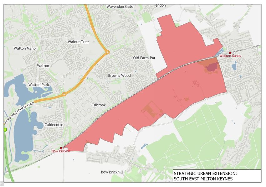
MM15 50 SD13 “A. Land is allocated at South East Milton Keynes – as shown on the Key Diagram and Policies Map – for a comprehensive residential-led mixed use
development of approximately 3,000 dwellings to meet the needs of Milton Keynes up to 2031 and beyond. If the chosen corridor for the Oxford
Cambridge Expressway (OCE) maintains the possibility that the OCE could be routed through the site, then planning permission for housing
and associated uses will not be permitted until 2019/20, once the detailed alignment of the Cambridge-Milton Keynes-Oxford Expressway OCE is
known.
B. In addition to the requirements set out in other policies within this plan, including policies INF1, SD1, SD11 and SD12, development of
the site will be required to:
1. Provide schools to accommodate seven forms of entry for secondary education and 6 forms of entry for primary education, as well
as necessary nursery and early years provision. Schools should be capable of dual use as community facilities.
2. Ensure Ddevelopment will be is well connected and integrated with the established MK grid squares to its north and west adjacent grid
squares, public transport services and the strategic and local highway grid network in line with the Council’s Mobility Strategy.
Provision of grade separated crossings of the railway should be provided or retained as appropriate to ensure connectivity of the
southern areas of the site with the remainder of the site and the city to the north in line with policies CT1-CT3 and CT5. The number,
location and purpose of any such crossings will be set out within the Development Framework.
3. The urban extension will Incorporate buffer areas, structural landscaping and strategic green infrastructure within the site to prevent
coalescence with Woburn Sands and Bow Brickhill, respect and reinforce the distinct character of the surrounding settlements of
Wavendon, Woburn Sands and Bow Brickhill through providing new or reinforced green buffers, thereby protecting existing settlement
character, ensure ecological connectivity, and mitigate any harm caused to the Brickhills area and wider landscape character.
4. Be informed by an archaeological field study, including a Geophysical Survey, to identify potential below ground archaeology.
Where feasible, the Council will expect below ground archaeology to be kept in situ in preference to its removal.
5. A site to accommodate 7 pitches for Gypsies and Travellers shall be provided as part of this development.
C. The development will be brought forward in line with all relevant policies in Plan:MK, particularly Policy SD1, SD11, SD12, NE1-7 and
INF1. A comprehensive development framework for the site will be prepared in accordance with policies SD1, SD11, SD12 and INF1 and approved
by the Council prior to planning applications being submitted permissions being granted.
15Plan:MK Schedule of Proposed Main Modifications
MM16 50 Map 1 Adjust boundaries for ‘Strategic Urban Extension: South East’ and reproduce Map 1 to reflect additional land
16Plan:MK Schedule of Proposed Main Modifications
MM17 51 Map 2 Adjust boundaries for ‘Strategic Urban Extension: Milton Keynes East’ and reproduce Map 2 to reflect additional land
17Plan:MK Schedule of Proposed Main Modifications
MM18 52 SD14 Land is allocated at Milton Keynes East – as shown on the Key Diagram and Policies Map – for a comprehensive new residential and employment
development to meet the long-term needs of Milton Keynes. Development will not can commence until after 2031 once unless the Council's bid
to the Government for the necessary strategic infrastructure required to make the site deliverable is fundeding is successful and is being
delivered. In that circumstance, the development of the site will be allowed to proceed within the plan period as an additional source of housing and
employment land supply.
Development will be brought forward in line with all relevant policies in Plan:MK, particularly Policies SD1, SD11, SD12 and INF1. A comprehensive
development framework for the site will be prepared in accordance with Policies SD1, SD11, SD12 and INF1 and approved by the Council
prior to planning permissions being granted.
Amongst others, the d The development framework and subsequent applications for planning permission will establish the quantum and
form of development in more detail, but proposals for development will comprise be expected to meet the following criteria:
Delivery of around 5,000 new homes, including at least 1,475 homes within the plan period, providing a range of sizes, types and tenures,
including affordable housing, in accordance with other policies in the Plan.
Around 105 hectares of land for a mix of employment uses, complementing the role and function of CMK Land for employment uses
B1c/B2/B8.
Associated infrastructure including primary and secondary education, community facilities, health, retail and local services and a hotel. The
development should comprise at least one district and/or local centre(s), of a scale commensurate to the needs of the new community
and that would not adversely affect the viability and vitality of Newport Pagnell district centre, with a co-location of key facilities.
The phased introduction of a comprehensive network of transport infrastructure in line with the Local Investment Plan, to include grid road
connections to H4/V11 to the west and improved highway connections to Newport Pagnell and Central Milton Keynes (CMK), including
new and/or enhanced vehicular crossings of the M1, involving highway works on and off-site.
A corridor of land safeguarded for a fast mass-transit system, and associated infrastructure, enabling connectingivity to CMK and other
key destinations Cranfield University. The width of the corridor should be sufficient to enable a range of possible transit solutions to
come forward whilst also ensuring the efficient use of land for achieving the scale of development proposed within this policy.
A network of segregated, and where appropriate grade-separated, new and enhanced footpaths, and cycleways and bridleways
(including redways) to connect to existing routes beyond the site, including redways provision of appropriate pedestrian and cyclist
crossings of the A422 and suitable safe and attractive crossings of the M1 as appropriate.
A strategic landscape green infrastructure framework and network of green spaces to meet strategic and local requirements that follows
the guidance in the Council’s Landscape Character Assessment and Green Infrastructure Strategy to ensure ecological connectivity,
protect the identity and character of nearby settlements and mitigate any significant impacts on the landscape in accordance with
Policy NE5.
The creation of a linear park through the site that broadly correlates with the River Ouzel floodplain and existing green infrastructure
assets of value within and adjacent to it.
Be informed by appropriate surveys of archaeology, built heritage and ecology with appropriate mitigation of impact as consistent
with other policies of the Plan and the NPPF. An archaeological field study, including a Geophysical Survey, where appropriate
following desk-based assessment, will required to identify potential below ground archaeology. Where feasible, the Council will
expect below ground archaeology to be kept in situ in preference to its removal.
MM19 54 Para 5.30 Add new sentence to para 5.30.
A comprehensive development framework for this site will be prepared and adopted by the Council prior to planning applications being
approved.
18Plan:MK Schedule of Proposed Main Modifications
MM20 59 Para 5.33 – 5.33 The Campbell Park grid square is located between H5 Portway, H6 Childs Way, V8 Marlborough Street and the Grand Union canal.
5.34 and Within this area, over the period of this plan, land between H5 Portway and Silbury Boulevard and land between Avebury Boulevard and H6
Policy SD18 Childs Way will be developed for new housing together with other facilities normally found within a residential area. If planning permission
17/00967/OUTEIS is implemented, a new pedestrian and cycle bridge over the Grand Union canal will connect Campbell Park to a new
marina and pub proposed in Newlands.
5.34 Located at the centre of Milton Keynes, the park area of Campbell Park has a mix of formal gardens, water features, woodland and
open pasture. It is the largest park within the city centre and one of the city’s greatest assets hosting many of Milton Keynes’ major
festivals and events. To encourage more people to visit the park, where opportunities arise, the Council will seek to improve links to the
park from the surrounding area. Planning applications which could affect the setting of the park will be assessed for their impact.
Site Allocations40
Policy SD18
CAMPBELL PARK
Development within Campbell Park must accord with the following principles.
Residential development should be designed:
1. To provide a range of well-designed good quality living environments.
2. To be flexible and adaptable meeting a range of needs including those of older people, young professionals and families.
The role of Campbell Park as the main city centre park will be maintained and links to the park will be improved where opportunities arise.
The impact of development proposals on the setting of the park will be considered in the determination of planning applications for those
proposals.
19Plan:MK Schedule of Proposed Main Modifications
MM21 80 ER11 Policy ER11
ASSESSING EDGE OF CENTRE AND OUT OF CENTRE PROPOSALS
Sequential Test
Proposals for main town centre uses which are outside defined Town Centre Areas, including significant edge of centre /out of centre retail
development and which are not on sites that are specifically allocated for such uses, will be subject to the sequential testing as required by
national planning policy. and will only be permitted where: Furthermore, any such proposal should The development would be readily accessible
by a choice of means of transport, including public transport, cycle and on foot, and by people with disabilities, or that such accessibility can be
provided.
Impact Test
Proposals for retail and leisure development which are outside a defined Town Centre Areas, and which are not on sites that are
specifically allocated for such uses, will be subject to an impact assessment as set out by national planning policy, subject to being above
the following thresholds:
A. Central Milton Keynes - 900 sq.m (gross)
B. All Other Centres - 350 sq.m (gross)
Furthermore, proposals for retail and leisure development over 900 sq.m (gross) which are within the city centre boundary of Central
Milton Keynes but are outside the Primary Shopping Area (PSA) as shown on the Policies Map, and which are not on sites that are
specifically allocated for such uses, will be subject to an impact assessment that seeks to assess the impact of the proposal on the PSA.
This should include assessment of:
a) The impact of the proposal on existing, committed and planned public and private investment in the PSA, and
b) The impact of the proposal on vitality and viability of the PSA, including local consumer choice and trade in the PSA.
1. The proposal would not have a significant adverse impact on the vitality and viability of the town centre and on existing, committed and
planned public and private investment within the centre or centres in the catchment area of the proposal and;
2. Applications for retail and/or leisure uses outside of the CMK primary shopping area which exceed 900 sq.m (gross) floorspace will be required
to undertake and provide an impact assessment in accordance with national planning policy. An impact assessment will also be required to
assess the impact of proposals for retail uses over 350 sq.m (gross) outside town, district and local centres within the Borough and;
20Plan:MK Schedule of Proposed Main Modifications
MM22 86 ER19 Policy ER19
NON-RETAIL USES ON GROUND FLOORS IN TOWN CENTRES
Planning permission will be granted for non- class retail A1 uses in town centres if they satisfy all of the following criteria:
1. The proposed use is appropriate within a town centre setting.
2. There is not an existing over-concentration of non- class A1 such uses within the town centre boundary. and they do not create a continuous
frontage of 3 or more units in non-retail use within the primary shopping frontage
3. The general restrictions on the location and proportion of on non-retail uses set
out in table 6.3 are met.
4. The proposed use would enhance the vitality of the town centre by extending
the range of facilities offered and/or stimulating activity outside normal shopping
hours.
5. The non-retail uses They would not have an adverse effect on any nearby residential
property.
6. The proposed use would maintain an appropriate window display to avoid the
creation of a dead frontage.
Above ground floor level, proposals for residential (class C3) financial and professional
services (class A2) and office floorspace (class B1a uses) will be encouraged.
Non retail uses are defined as defined as any use class other than class A1 (Shop uses) as defined in the 1987 Use Classes Order as
amended.
MM23 86 Table 6.3
KINGSTON
Change of use involving the loss of A1 retail will not normally be acceptable
Primary Frontages
Change of use from one non-retail to another non-retail use may be acceptable
Change of use from non-retail use to A1 retail use will be encouraged
21Plan:MK Schedule of Proposed Main Modifications
MM24 97 HN2 A.i A. Development Proposals for 11 or more homes should provide at least 31% and generally no more than 50% of those homes as affordable
housing. Proposals that provide greater than 31% of homes as affordable housing will be strongly supported. However, proposals
consisting of 50% or more affordable housing will only be supported provided that they would maintain (or help create) a mix of housing
tenures and therefore a mixed and sustainable community within the wider neighbourhood the proposal is situated in.
The tenure mix of affordable housing to be provided will consist of:
i. 25% of units for rent at a range of rental levels up to 80% of market rents (but at no more than Local Housing Allowance rates), under the
Affordable Rent model, including approximately 5% of the total affordable provision at a level broadly equivalent to Social Rent (at the time an
application is considered).
ii. 6% Shared Ownership (based on a range of 25%-40% equity share).
B. In seeking affordable housing provision the Council will have regard to the current viability of developments, including land values and other
development costs. Where it has been demonstrated to the Council’s satisfaction through the submission of viability evidence, which is open and
transparent, that the provision of affordable housing in accordance with the above levels and tenure mix would deem the scheme unviable then the
Council will take a flexible approach to achieving viability as follows:
i. Reviewing the tenure mix;
ii. Reviewing the extent of other site specific planning obligations; and
iii. The proportion of affordable housing.
In exceptional circumstances off-site provision or financial contributions of equivalent value may be accepted.
C. Where a development is proposed that complies with the outlined Milton Keynes Council definition for Build to Rent housing, the full
requirement for 31% affordable housing offer set out in Part A above can should be provided entirely as discounted market rent (DMR) to be
managed by the Build to Rent provider. Alternatively, a financial contribution in lieu of the provision of on-site affordable housing will be accepted. In
this case, the financial contribution to be provided would be subject to a viability assessment.
Where the development proposes to provide For affordable housing provided at DMR, the Council will require housing costs rent levels
(including service charges) to be set at no more than 31% of a gross household income80% of market rents or the Local Housing Allowance
rates, whichever is the lowest. Household income data for Milton Keynes should be calculated using the most up to date data from the
Office of National Statistics (ONS - or any successor government body/agency). If the ONS subsequently publishes data at a Milton Keynes
administrative district level, then this will be preferred.
Any rent set should be below the median private sector rent for the applicable dwelling type in Milton Keynes as set out by the Valuation
Office Agency (or any successor government body/agency) Statistics in its Private Rental Market.
D. All affordable housing provision secured through planning will be required to be affordable in perpetuity, in line with the requirements of the NPPF. Therefore,
should the developments be sold onto the open market at any time, during or after the covenant period, then a commuted sum would need to be paid to the
Council to secure the affordable housing provision in perpetuity, or replacement affordable housing would need to be provided of an equivalent value.
The preparation of the Council’s Affordable Housing SPD will assist in the implementation of this policy.
22Plan:MK Schedule of Proposed Main Modifications
MM25 103 HN5 SELF-BUILD AND CUSTOM HOUSEBUILDING
The allocations set out within Plan:MK will be required to make provision for serviced plots of land to contribute towards meeting the
evidenced demand for Self-build and Custom Housebuilding in the Borough.
The Council supports the aspirations of self-build and custom-build homes and will strongly support proposals for self-build and custom
housebuilding that involve the creation of low-cost and affordable housing.
To further support prospective custom builders, the strategic growth areas allocated within Plan:MK, and any proposals for further
strategic residential development, will be required to provide 1 hectare of the site for serviced dwelling plots for sale to custom builders to
contribute towards meeting the evidenced demand for self-build and custom housebuilding in the Borough.
Self- build plots being delivered under Policy HN5 will be expected to be marketed for a minimum period of 12 months once made
available. If, once plots have been marketed for the minimum period, they have not sold they may then remain on the market as self-build
plots, be offered for purchase to the Council or partner Housing Associations, or be built out by the landowner as appropriate.
MM26 110 HN11 Remove Criterion:
vii. The development would not be prominent from public vantage points
MM27 139 EH8 Hot food takeaways (Class A5) which are proposed within close proximity to a primary or secondary school will only be permitted if: the takeaway is
located more than 400m from the main school entrance.
•The takeaway is located a minimum of 400m from the school entrance.
The 400m distance will be assessed on the most logical walking distance from the main school entrance
The Council may impose conditions restricting opening hours of hot food takeaways
MM28 139 9.40 The Council has produced an indicative map (refer to Appendix K). This confirms the intent of the policy is to manage food options in
proximity to schools to address the prevalence of overweight and obesity in children. As such, Policy EH8 would not result in a
moratorium on additional Hot Food Takeaway provision in the Borough including locations such as CMK and a number of district/town
centres. More detailed analysis of the 400m logical walking distance on a case by case basis may provide some further flexibility.
MM29 145 FR1 All new development must incorporate a surface water drainage system with acceptable flood control and demonstrate that water supply, foul
sewerage and sewage treatment capacity is available or can be made available in time to serve the development. Suitable access is safeguarded for
the maintenance of water supply and drainage infrastructure.
…
3. To ensure that there will be no increase in flood risk to the site or surrounding area, and, if possible, there will be an improvement to the existing
situation, taking into account climate change opportunities to reduce the causes and impacts of flooding to the site and the surrounding area
are taken as far as possible, in order to improve the existing situation, taking into account climate change. At a minimum, proposals will
need to demonstrate no increase in flood risk to the site or surrounding area;
…
11. To consult the Fire and Rescue Service as to the feasibility of undertaking rescue and recovery operations during and in the aftermath
of flooding events”.
23Plan:MK Schedule of Proposed Main Modifications
MM30 146 FR2 Plan:MK advocates the continuation of a strategic, integrated approach to managing flood risk which …
2. Space will be specifically set aside for SuDS and fluvial flood risk reduction features and used to inform the overall layout of development sites.
…
4. SuDS will be designed as multi-purpose green infrastructure and open space, to provide maximise additional environmental, biological
diversity, social and amenity value, wherever possible. The use of land to provide flood storage capacity should not conflict with required amenity
and recreation provision – floodplains and floodplain habitats should be safeguarded.
…
7. All surface water drainage proposals for new development must include full details of the means of achieving future management, maintenance
and adoption of the systems, prior to approval of any planning permission, to ensure that it will function effectively over the lifespan of the
development. This will include details of funding and should be formulated through discussion with the relevant responsible bodies, including
Milton Keynes Council, The Parks Trust, Anglian Water and the Internal Drainage Board.
…
8. Development will ensure no adverse impact on the functions and setting of a watercourse and its associated corridor.
…
9. Development should avoid building over or culverting watercourses, encourage the removal of existing culverts and seek opportunities
to create wetlands and wet grasslands and woodlands and restore natural river flows and floodplains.
24Plan:MK Schedule of Proposed Main Modifications
MM31 152 NE1 A. Development proposals which would likely cause harm to the nature conservation or geological interest of internationally (RAMSAR sites, SACs
and SPAs) important sites will not be permitted unless:
1. There is no suitable alternative to the development;
2. There are imperative reasons of overriding public interest;
3. All reasonable possibilities for mitigation have been put in place; and
34. Compensatory provision in line with the mitigation hierarchy can be secured to ensure that the overall coherence of the site is protected
and with the intent to achieve a net gain in biodiversity.
B. Development proposals which would likely cause harm to a National Nature Reserve, Site of Special Scientific Interest or irreplaceable habitats
such as Ancient Woodland will not be permitted unless:
d1. There is no suitable alternative to the development;
e2. The benefits of the development, at this site, clearly outweigh the adverse impacts on the site;
f3. All reasonable possibilities for mitigation have been put in place; and
4. Compensatory provision in line with the mitigation hierarchy can be secured that will mitigate damaging impacts on the biodiversity or
geological conservation value of the site. to ensure that the overall coherence of the site is protected and with the intent to achieve a
net gain in biodiversity.
C. Development proposals which would be likely to harm the biodiversity or geological conservation value of a site of county-wide or local
importance[1] as shown on the Policies Map a site of county-wide (MK Wildlife Sites, Wildlife Corridors) or local importance (Local Nature
Reserves, Biological Notification Sites, local wildlife sites) or sites which serves as a 'biodiversity offset site' will only be permitted where:
d1. The local development needs significantly outweigh the biodiversity or geological conservation value of the site; and
e2. The development provides appropriate avoidance/mitigation/compensation measures All reasonable possibilities for mitigation
have been put in place; and
3. Compensatory provision in line with the mitigation hierarchy can be secured that will to offset any damaging impacts on the
biodiversity or geological conservation value of the site or its wider ecological network to ensure that the overall coherence of the
site is protected and with the intent to achieve a net gain in biodiversity.
D. If significant harm resulting from a development cannot be avoided, adequately mitigated, or as a last resort compensated for, then
planning permission will be refused.
[1] Including MK Wildlife Sites, Wildlife Corridors, Local Nature Reserves, Ancient Woodland, Traditional Orchards, Local Wildlife Sites, Biological
Notification Sites, Biodiversity Opportunity Areas and Local Geological Sites.
MM32 153 NE2 A. Whenre there is a reasonable likelihood of the presence of statutorily protected species or their habitats, or where the site contains priority
species or habitats identified in the Buckinghamshire and Milton Keynes Biodiversity Action Plan, development will not be permitted until
unless it has been demonstrated that the proposed development will not result in a negative impact upon those species and habitats.
B. Where the site contains priority species or habitats, development should wherever possible promote their preservation, restoration,
expansion and/or re-creation in line with Policy NE3.
Priority Habitats are shown on the Policies Map accompanying this plan.
25Plan:MK Schedule of Proposed Main Modifications
MM33 153 NE3 A. Development proposals will be required to maintain and protect biodiversity and geological resources, and wherever possible enhance result in
measurable net gain in biodiversity, enhance the structure and function of ecological networks and the ecological status of water bodies in
accordance with the vision and principles set out by the Buckinghamshire and Milton Keynes NEP.
B. Development proposals must demonstrate that the mitigation hierarchy has been followed to firstly avoid, reduce and mitigate direct
and indirect adverse impacts before considering compensation. If significant harm to biodiversity resulting from a development cannot be
avoided, adequately mitigated or, as a last resort, compensated for then planning permission should be refused.
C. Where compensation is required, appropriate enhancements will be sought on 'biodiversity offset sites' by provision of replacement
habitat of higher quality to achieve a net gain in biodiversity. A Biodiversity Impact Assessment metric should be used to inform what
compensation will be required. Development proposals of 5 or more dwellings or non-residential floorspace in excess of 1,000 sq. m will
be required to use the Defra metric or locally approved Biodiversity Impact Assessment Metric to demonstrate any loss or gain of
biodiversity.
D. Mitigation, compensation and enhancement measures must be secured and be maintained for the lifetime of the development.
Enhancement and compensatory measures should seek opportunities for habitat protection, restoration and creation to meet the objectives of the UK
and Bucks & Milton Keynes Biodiversity Action Plan and aims of the Biodiversity Opportunity Areas. These measures should also create and
enhance habitats to help wildlife adapt to the impact of climate change.
26You can also read