Bushfire Assessment and Development Report - for the Waurn Ponds Train Maintenance and Stabling Facility at 255 Reservoir Rd, Waurn Ponds - Planning
←
→
Page content transcription
If your browser does not render page correctly, please read the page content below
Bushfire Assessment and
  Development Report
        for the Waurn Ponds
Train Maintenance and Stabling Facility
  at 255 Reservoir Rd, Waurn Ponds

         Report commissioned by
                 AECOM

               June 2019

    WWW.TERRAMATRIX.COM.AU

       WWW.TERRAMATRIX.COM.AU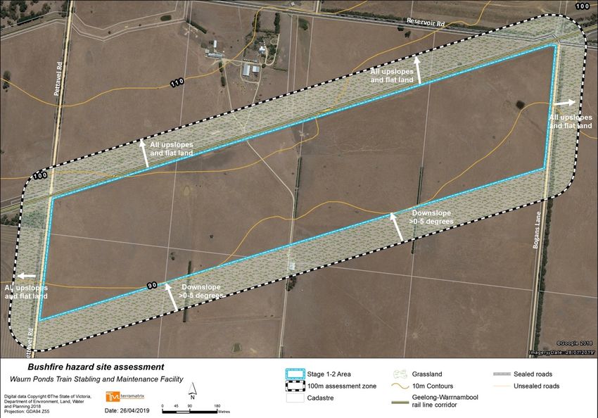
Bushfire Assessment and Development Report for 255 Reservoir Road, Waurn Ponds

Terramatrix project: AECOM-2018-02 BMP-Waurn Ponds

Terramatrix Pty. Ltd.
ACN 129 163 373
ABN 44 129 163 373
PO Box 1391, Collingwood VIC 3066
P: 03 9417 2626
www.terramatrix.com.au

Approvals
   Accountability                         Name                                           Signature

   Analysis, mapping and                  John Eastwood & Amalie Tibbits
   report compilation

                                          Hamish Allan, Manager Bushfire
   Peer review
                                          Planning and Design

Copyright
Unless otherwise agreed in writing, this report is the intellectual property of Terramatrix. The report is designed to be used exclusively by
the person that commissioned it. Permission must be sought prior to the reproduction of any portion of this document and every effort
made to ensure proper referencing of this document.

Disclaimer
This report may be of assistance to you and has been made with careful consideration and with the best information available to
Terramatrix at the time of writing. Before relying on information in this report, users should carefully evaluate the accuracy, completeness
and relevance of the information provided for their purposes. Terramatrix Pty Ltd, its directors and employees do not guarantee that it is
without flaw or omission of any kind or is wholly appropriate for your particular purposes and therefore disclaim all liability for any error,
loss or other consequence that may arise from you relying on any information in this report.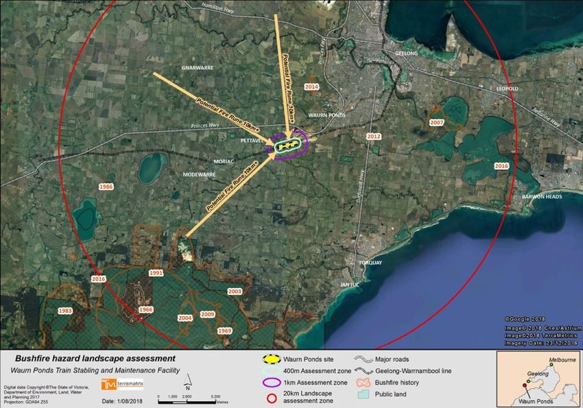
Bushfire Assessment and Development Report for 255 Reservoir Road, Waurn Ponds

                                                                      Contents
1      INTRODUCTION ...................................................................................................................... 1
    1.1    PROJECT DESCRIPTION ................................................................................................................ 1
       1.1.1       Staged Delivery ............................................................................................................................... 2
    1.2        CONSTRUCTION PHASE ............................................................................................................... 4
    1.3        OPERATIONAL PHASE.................................................................................................................. 6
    1.4        SITE SUMMARY .......................................................................................................................... 8
    1.5        LOCATION DESCRIPTION .............................................................................................................. 8
2      PLANNING AND BUILDING CONTROLS ................................................................................... 13
    2.1    MINISTERIAL DIRECTION NO. 11 ................................................................................................ 13
    2.2    PLANNING POLICY FRAMEWORK (PPF) ........................................................................................ 13
    2.3    BUSHFIRE PRONE AREA (BPA) ................................................................................................... 14
    2.4    OTHER DEVELOPMENT CONTROLS ............................................................................................... 15
       2.4.1       Zoning ........................................................................................................................................... 15
       2.4.2       Overlays ........................................................................................................................................ 15

3      METHODOLOGY OVERVIEW AND ASSUMPTIONS .................................................................. 16
    3.1    AS 3959-2018....................................................................................................................... 16
4      BUSHFIRE HAZARD LANDSCAPE ASSESSMENT ....................................................................... 17
    4.1    LANDSCAPE CONDITIONS ........................................................................................................... 17
    4.2    LOCAL AND NEIGHBOURHOOD CONDITIONS .................................................................................. 18
5      BUSHFIRE HAZARD SITE ASSESSMENT ................................................................................... 21
    5.1    VEGETATION ........................................................................................................................... 21
       5.1.1       Grassland ...................................................................................................................................... 21
       5.1.2       Excluded vegetation and non-vegetated areas............................................................................. 21
    5.2        TOPOGRAPHY .......................................................................................................................... 22
    5.3        BAL DETERMINATION ............................................................................................................... 22
6      PLANNING AND DEVELOPMENT RESPONSE ........................................................................... 27
    6.1    DEVELOPMENT RESPONSE ......................................................................................................... 27
       6.1.1       Building compliance ...................................................................................................................... 27
       6.1.2       Other structures and infrastructure .............................................................................................. 28
       6.1.3       Vegetation management .............................................................................................................. 30
       6.1.4       Access and Water ......................................................................................................................... 30
       6.1.5       Preventing ignition and fire spread onsite .................................................................................... 30
       6.1.6       Site Management Plan.................................................................................................................. 31
       6.1.7       Bushfire emergency management planning ................................................................................. 31
       6.1.8       Bushfire mitigation measures ....................................................................................................... 32
    6.2        CLAUSE 13.02 BUSHFIRE .......................................................................................................... 32
7      CONCLUSION ........................................................................................................................ 39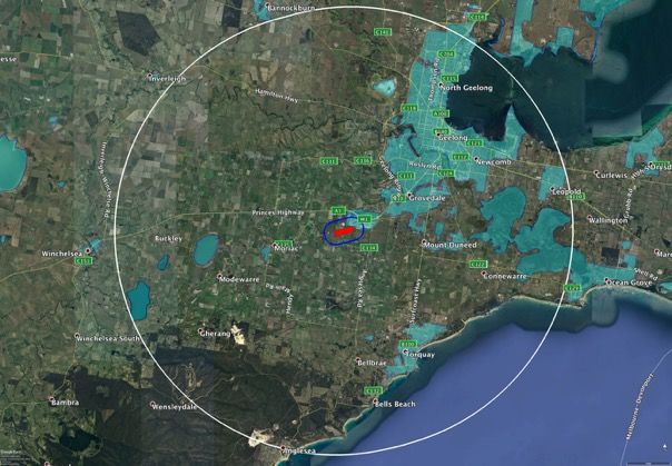
Bushfire Assessment and Development Report for 255 Reservoir Road, Waurn Ponds

APPENDIX 1:        BAL CONSTRUCTION STANDARDS ......................................................................... 40
APPENDIX 2:        BMO VEGETATION MANAGEMENT REQUIREMENTS ............................................. 41
APPENDIX 3:        BMO ACCESS REQUIREMENTS .............................................................................. 42
APPENDIX 4:        BMO STATIC WATER SUPPLY REQUIREMENTS ...................................................... 43
8   REFERENCES .......................................................................................................................... 45
Bushfire Assessment and Development Report for 255 Reservoir Road, Waurn Ponds

1 Introduction
This Bushfire Development Report (BDR) has been prepared for AECOM on behalf of Rail Projects
Victoria (RPV) to demonstrate how the proposed development of land for the ‘Waurn Ponds Train
Maintenance and Stabling Facility’ (the Project) at 255 Reservoir Road, Waurn Ponds, can respond to
the Victorian planning and building controls that relate to bushfire, specifically the requirements for
development in a Bushfire Prone Area (BPA) including Clause 13.02 Bushfire.

The entire Project area is in a designated Bushfire Prone Area (BPA). This report addresses the
requirements for building in a BPA in accordance with AS 3959-2018 Construction of buildings in
bushfire-prone areas. The assessment has also been undertaken to meet the objectives and
strategies for development at Clause 13.02 Bushfire in the Planning Policy Framework (Greater
Geelong Planning Scheme, 2018). The site is not covered by the Bushfire Management Overlay
(BMO).

Meeting the objectives and strategies for development at Clause 13.02 Bushfire will also satisfy the
requirements of Ministerial Direction 11 Strategic Assessment of Amendments, which states that an
amendment must address any relevant bushfire risk (Direction No. 11, 2013).

The assessment has been undertaken consistent with guidance provided in Planning Practice Note 46
Strategic Assessment Guidelines for preparing and evaluating planning scheme amendments (DELWP,
2017a) and Planning Advisory Note 68 Bushfire State Planning Policy Amendment VC140 (DELWP,
2018).

It is noted that the CFA, as the relevant fire authority, have provided feedback on the development
proposal in a letter dated 27 October 2017. The opinion of the CFA was that the proposed
development does not create a risk to neighbouring farmland. The CFA recommended that:
 • A ring road be constructed on the inside perimeter of the fencing;
 • The CFA State Infrastructure and Dangerous Goods Team be consulted during the design phase;
     and
 • RPV provide the responding brigades with a site tour and induction once development is
     complete.
An internal road has been provided on the plan (see Map 3) which meets the intent of the CFA
advice. This report recommends that the CFA State Infrastructure and Dangerous Goods Team be
consulted during the design phase and RPV provide the responding brigades with a site tour and
induction once development is complete in accordance with the recommendations from the CFA.

1.1 Project description
The Project will insert an incorporated document into the Planning Scheme to facilitate the use and
development of the facility. The project land comprises all areas of land required within the site for
the purposes of the Project, at 255 Reservoir Road extending 350 metres south of the rail reserve
between Pettavel Road and Bogans Lane (see Figures 1 and 2).

                                                     1
Bushfire Assessment and Development Report for 255 Reservoir Road, Waurn Ponds

The wider project land includes all land that the Project requires for delivery of ancillary
infrastructure and associated construction activity:
• At 255 Reservoir Road:
    -    Approximately 50 metres north of the rail corridor between Pettavel Road and Reservoir
         Road/Bogans Lane. It is anticipated that only a small portion of this wider project land will
         be required, subject to the determination of the ultimate location of the occupational
         crossing as part of Stage 2 of the project.
•   Surrounding 255 Reservoir Road:
    -    Within the existing rail corridor for approximately 3040 metres west and for 3550 metres
         east of Bogans Lane inclusive;
    -    Within the Bogans Lane road reservation, 500 metres south of Reservoir Road;
    -    Within the Pettavel Road road reservation, 170 metres north of the rail corridor and 480
         metres south of the rail corridor;
    -    Within the Reservoir Road road reservation, 800 metres east of, and including its
         intersection with Bogans Lane.

1.1.1 Staged Delivery
It is proposed to deliver the Project in two stages with stage 1 expected to be delivered by 2021.
Delivery of the balance of the Facility (Stage 2) is subject to further Government decision making in
relation to the funding and procurement of new trains to service the Geelong Line and broader
regional rail network and associated stabling and maintenance requirements. The timing for delivery
of Stage 2 is unknown at this time. Stage 2 may be delivered in one or more stages depending on the
outcome of this decision making.

1.1.1.1 Stage 1 Infrastructure
Stage 1 is anticipated to deliver a train stabling facility with the capacity to stable 6 trains. It is
anticipated that the facility will primarily cater for VLocity/DMU trains, however, it is proposed to
have capacity to cater for 3 locomotive trains in the short-term while locomotives continue to be
phased out of the V/Line fleet. The facility would be located south of the existing railway corridor,
directly east of the existing farm laneway at the centre of the Site, and west of Bogans Lane. The
Stage 1 facility would occupy an area of approximately 11 hectares, and would be in the order of
1030 metres long, 150 metres wide at its widest section and 100 metres wide at its most narrow
point.

Stage 1 is anticipated to comprise:
Initial site development
• Land acquisition for the entire footprint of Stage 1 and Stage 2;
• On-site mobilisation;

                                                     2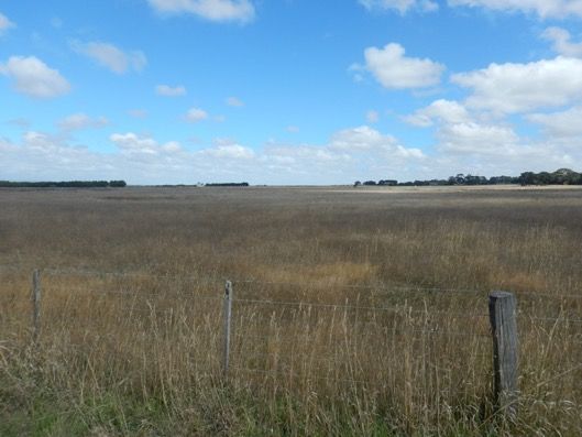
Bushfire Assessment and Development Report for 255 Reservoir Road, Waurn Ponds

•   Connections to key services (electricity, water, sewerage, drainage, communications, etc.);
•   Security fencing and entrance/exit gates around the perimeter of the stabling roads and Stage 1
    facilities;
•   Earthworks to support initial facilities and trackwork;
•   Landscaping;
•   Road access from Bogans Lane;
•   Power and dam infrastructure works resulting from the acquisition of farmland for the facility
    site;
•   Modified stock crossing and vehicular access to the adjacent leasehold farm property (i.e. the
    Boral owned land to the east);
•   It is expected that the existing level crossing that serves the central farm laneway will remain in
    operation at its current location, potentially with some modifications as required by V/Line.

Track layout
• Six stabling roads, comprising four single ended and two double ended stabling roads;
•   One single entry/exit train access point from existing rail corridor towards the eastern end of
    the site, just west of Bogans Lane.

Servicing facilities
• Fuelling facilities on four stabling roads;
•   Power, toilet extraction and water replenishment equipment, footpaths and yard lighting
    provided on all of the stabling roads.

Ancillary facilities
• Upgrades to the existing signalling system within the rail corridor;
•   Waste compound for rubbish and hard waste;
•   Bunded fuelling area;
•   Water storage and supply for stabling sidings;
•   Drainage systems, including water sensitive urban design (WSUD) and the modification or
    relocation of farm dams;
•   Telecommunications;
•   Asphalt footpaths;
•   CCTV to cover stabling sidings area;
•   Driver and cleaner’s amenities;
•   Formed and sealed access roadways, with capacity to allow for B-double truck access and
    turnaround;
•   Car parking for drivers, visitors and cleaners.

                                                      3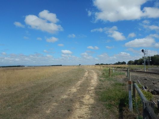
Bushfire Assessment and Development Report for 255 Reservoir Road, Waurn Ponds

1.1.1.2 Stage 2
As stated above, Stage 2 is subject to further Government decision making. However, it is
anticipated that Stage 2 will increase the stabling capacity of the Facility to 26 trains and will
introduce a train maintenance facility. Based on an indicative concept design, the Stage 2 facility is
anticipated to occupy an area of approximately 46 hectares, and be in the order of 1720 metres long,
320 metres wide at its widest section and 160 metres wide at its narrowest.
Stage 2 is anticipated to comprise:
Site development
• Security fencing and entrance/exit gates around the perimeter of the Stage 2 facility;
•   Earthworks to support expansion of facilities and trackwork;
•   Landscaping;
•   A rerouting of the farm laneway to cross the rail corridor in proximity to the Pettavel Road
    boundary of the Site.
Rail facilities
• Two access points from existing rail corridor, one towards the eastern end of the site and one
      towards the western end of the site;
•   Stabling roads for up to 26 trains;
•   Bio-wash facilities;
•   Train wash facilities;
•   A maintenance facility with 5 maintenance roads.
Servicing facilities
• Expansion of fuel and water facilities;
•   A substation;
•   Expansion of staff facilities;
•   One gatehouse along the entry road.
Ancillary facilities may include the following:
• Drainage systems, including WSUD and the modification or relocation of farm dams;
•   Telecommunications;
•   Internal/external access arrangements;
•   Utility protection and installation;
•   Signalling infrastructure;
•   Emergency access via Pettavel Road.

1.2 Construction Phase
1.2.1.1   Construction Activities

                                                         4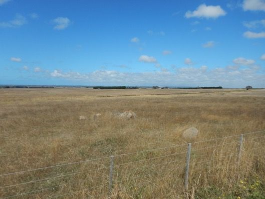
Bushfire Assessment and Development Report for 255 Reservoir Road, Waurn Ponds

Key construction activities anticipated for the Project include:
Table 1 Construction Activities
 Stage                Construction Activities
 Stage 1
 Site                 •    On-site mobilisation;
 Development          •    Connections to key services (electricity, water, sewerage, drainage,
                           communications);
                      •    Security fencing and entrance/exit gates;
                      •    Earthworks to support initial facilities and trackwork;
                      •    Road access from Bogans Lane;
                      •    Initially required internal roads; and
                      •    Security and safety facilities.
 Works                •    Construction of internal roads, footpaths, car parking and associated
                           sealing;
                      •    Construction of new rail tracks and associated signalling systems;
                      •    Construction of fuelling facilities;
                      •    Reinstatement and landscaping;
                      •    Installation of utility infrastructure;
                      •    Bulk earthworks; and
                      •    Construction of ancillary buildings and services.
 Stage 2
 Works                •    Construction of train maintenance building and internal fit out;
                      •    Construction of additional tracks and connections;
                      •    Modifications to the fuelling facility;
                      •    Automated train wash plant and bio-wash;
                      •    Extension of stabling sidings;
                      •    Expansion of staff amenities and training facilities;
                      •    Provision of train cleaners store and amenities building;
                      •    Expansion of staff car parking;
                      •    Provision of train crew administration facilities.

Being grazed farmland, the site is already substantially cleared of vegetation. The exception is two
areas of linear shelterbelt vegetation. Vegetation removal will be minimised to the extent practical
and occur progressively throughout all activities.

1.2.1.2 Construction Operation
The construction duration is expected to be approximately 12 to 18 months for each stage of the
Project, and subject to the Project requirements at the time. During each phase, the construction
operating hours will be undertaken in accordance with the relevant protocols.

During the site preparation and construction phases, access to the site is anticipated to be provided
via Bogans Lane for Stages 1 and 2. Alternative access may be possible from Pettavel Road for Stage
2.

                                                      5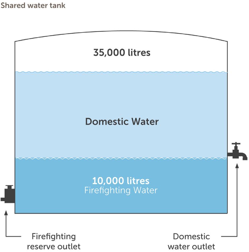
Bushfire Assessment and Development Report for 255 Reservoir Road, Waurn Ponds

Vehicle movements would be coordinated as required and advised by standard traffic management
measures.

The preferred site access route during construction of the site is via the Geelong Ring Road.
Alternatively, access to the site can be provided via Princes Highway.

1.2.1.3 Staff Numbers
During the construction phase it is expected that up to 100 personnel could be on-site at any one
time.

1.3 Operational Phase
This section describes the expected operational activities.
Operational activities are subject to completion of the detailed design phase for each stage of the
Project and confirmation of the operator’s timetabling requirements.

1.3.1.1 Operation of Train Stabling and Maintenance Facilities
The Facilities are anticipated to operate 24 hours a day, seven days a week.
It is expected that trains will enter and exit the facility from turnouts constructed off the mainline.
The layout of the track work would enable flexibility for the train operator and maintainers to
minimise any potential conflicting train movements, and reduce the overall amount of shunting time
onsite for the trains.

It is anticipated that trains will enter and exit the site during the day and night as required to serve
the railway timetable. Trains may arrive/depart at 10 minute intervals during peak periods. The
total number of train arrivals and departures per day is not yet known and will be subject to the
operator’s timetabling requirements.

It is assumed that up to 3 trains may be idling at any one point in time during Stage 1 operations.
The total number of trains idling as part of Stage 2 is subject to future detailed design and
operational requirements. These assumptions will be reviewed subject to the operator’s timetabling
requirements.

The overall operational concept for the Facility is to provide an efficient series progression for
stabling, servicing and maintenance (if required) of trains from initial train arrival until its next
scheduled departure into revenue service. Typical train movements would be entry through the
northern most fuelling roads, continuing through to the western most shunting neck. From here the
train would head east into the stabling roads where it would reside prior to departure. If
maintenance was required, trains would leave the stabling siding and enter the maintenance facility.

                                                      6
Bushfire Assessment and Development Report for 255 Reservoir Road, Waurn Ponds
1.3.1.2 Staff numbers
It is anticipated that the Facility may accommodate 10 staff during Stage 1 of the Project and 40 staff
during Stage 2, with the expectation that all staff will not be on site at any one time, and staff will
work in shifts. An expected breakdown of shift allocation is as follows:
Table 2 Staff Numbers
Number of Staff for Number of Staff for
Shift Time Staff Percentage
Stage 1 Stage 2
Morning 40% 4 16
Afternoon 40% 4 16
Overnight 20% 2 8
1.3.1.3 Vehicle and Staff access
The primary access point to the Facility would be located to the east from Bogans Lane. The
preferred access route to the site from the Geelong Ring Road would be via Anglesea Road and
Reservoir Road. Vehicles will be expected to exit the site the same way.
The primary access gate is to be utilised by staff and delivery vehicles to both enter and exit the
facility. Visitors and administration office personnel would be directed to the relevant area and
directed to the car park after checking-in, identification and registration at the primary access gate.
For Stage 2, emergency vehicle access could be provided at the western end of the site from Pettavel
Road, where required. Appropriate internal access would also be provided for emergency vehicles to
the maintenance workshop, stabling tracks and main parts of the Facility.
The internal road layout would be designed to limit the need to cross tracks within the site.
Adequate car parking spaces will be provided for both maintenance and operations staff and visitors.
It is expected that car parking areas will be located to minimise walking distances to site facilities.
Pedestrian movement networks would be designed to provide adequate access, minimise walking
distances to site facilities and provide for personal safety.
7Bushfire Assessment and Development Report for 255 Reservoir Road, Waurn Ponds
1.4 Site summary
Address: 255 Reservoir Road, Waurn Ponds, VIC 3216
Municipality: City of Greater Geelong
Zone/s Farming Zone and Schedule (FZ)
Overlay/s None
Directory reference: VicRoads 93 F5
Assessment date: 6th March 2017
Assessor: John Eastwood - Analyst
1.5 Location description
The site is located approximately 13km southwest of the Geelong CBD and is immediately adjacent
to the Geelong-Warrnambool rail line (see Figures 1, 2, 3 and Map 1). The surrounding landscape is
gently undulating, rising gradually from the southeast to the northwest and is dominated by grassed
pastoral land for at least 10km. The Bellarine Peninsula to the east and the Victorian volcanic plain to
the west and northwest largely comprise the same gently undulating areas of pasture extending
beyond 10km from the site. There is an area of extractive industry (Boral Quarries) immediately to
the northeast, and beyond that the suburb of Waurn Ponds, which is contiguous to the Geelong
urban area.
The region is bisected by the Princes Highway and the Geelong-Warrnambool rail line, with an
extensive local road network. Further afield, the forested areas of the Great Otway National Park
and the Alcoa lease area near Anglesea are located approximately 13km to the southwest, with
minor patches of treed vegetation scattered across the landscape generally following property lines
and waterways.
8Bushfire Assessment and Development Report for 255 Reservoir Road, Waurn Ponds
Figure 1 – Project area (red fill) with 1km and 20km radii (blue and white outlines respectively) as per Clause
13.02 landscape assessment methodology. Note that non-BPA land is shown in semi-transparent light blue.
(Image © 2018 CNES/Airbus, Data SIO, NOAA, US Navy, NGA, GEBCO, © 2018 Google, Image © 2018
DigitalGlobe; Imagery date 2017/03/19).
9Bushfire Assessment and Development Report for 255 Reservoir Road, Waurn Ponds
Figure 2 – Regional context (Rail Projects Victoria, 2019).
10Bushfire Assessment and Development Report for 255 Reservoir Road, Waurn Ponds
PROJECT ID 60535095
CREATED BY GC
LAST MODIFIED GC 06 JUL 2018 www.aecom.com
´
DATUM GDA 1994, PROJECTION MGA ZONE 55
0 100 200 400
Metres
1:21,218 (when printed at A3)
LEGEND
Project Area
Wider Project Area
Rail Line
Parcel Boundaries
GREATER
GEELONG
Data sources:
Base Data: (c) 2017 (VicMap)
Service Layer Credits: Source: Esri,
DigitalGlobe, GeoEye, Earthstar Geographics,
CNES/Airbus DS, USDA, USGS, AeroGRID,
SURF COAST IGN, and the GIS User Community
PROJECT AREA
Client
Rail Projects Victoria
Project:
Waurn Ponds Train Stabling and
Maintenance Facility
A3 size
Figure 3 - Project Area (Rail Projects Victoria, 2019).
11Bushfire Assessment and Development Report for 255 Reservoir Road, Waurn Ponds
Figure 4 - Concept Plan (Rail Projects Victoria, 2019) (see also Maps 2 and 3).
12Bushfire Assessment and Development Report for 255 Reservoir Road, Waurn Ponds
2 Planning and Building Controls
This section identifies applicable bushfire planning and building controls.
2.1 Ministerial Direction No. 11
Ministerial Direction No. 11 Strategic Assessment of Amendments requires a comprehensive strategic
evaluation of most planning scheme amendments and the outcomes they produce, including an
evaluation and explanation of how an amendment addresses any relevant bushfire risk (Direction
No. 11, 2013).
It is considered that this report meets the requirements of Ministerial Direction No. 11 as
appropriate.
2.2 Planning Policy Framework (PPF)
Clause 13.02 Bushfire has the objective 'To strengthen the resilience of settlements and communities
to bushfire through risk based planning that prioritises the protection of human life’ (Greater Geelong
Planning Scheme, 2018a). The policy must be applied to all planning and decision making under the
Planning and Environment Act 1987 relating to land which is:
• Within a designated BPA;
• Subject to a BMO; or
• Proposed to be used or developed in a way that may create a bushfire hazard.
Clause 13.02 requires priority to be given to the protection of human life by:
• ‘Prioritising the protection of human life over all other policy considerations.
• Directing population growth and development to low risk locations and ensuring the
availability of, and safe access to, areas where human life can be better protected from the
effects of bushfire.
• Reducing the vulnerability of communities to bushfire through consideration of bushfire risk in
decision-making at all stages of the planning process’ (ibid.).
Other strategies are also provided in relation to:
• Bushfire hazard identification and assessment;
• Settlement planning;
• Areas of high biodiversity conservation value; and
• Use and development control in a BPA.
The way in which the Project gives effect to each of the strategies is discussed in Section 6.
Clause 21.05-1 in the Greater Geelong Planning Scheme identifies bushfire as a key issue and
influence: ‘A number of areas in the municipality are susceptible to wildfire hazard, including some
13Bushfire Assessment and Development Report for 255 Reservoir Road, Waurn Ponds
grasslands around Lara, the foothills of the Brisbane Ranges, and parts of the Anakie township’
(Greater Geelong Planning Scheme, 2010a).
Clause 21.05-8 Wildfire has the stated objective ‘To minimise the impacts of wildfire’ and the
strategies to achieve the objective are to ‘Identify areas at risk of wildfire’ and ’Ensure that
development in identified areas considers the impacts of wildfire’ (Greater Geelong Planning Scheme,
2010b).
This report appropriately responds to these objectives and strategies.
2.3 Bushfire Prone Area (BPA)
The Project is in a designated Bushfire Prone Area (BPA, see Figures 1 and 5). BPAs are those areas
subject to or likely to be subject to bushfires, as determined by the Minister for Planning.
In Victoria, the Building Act 1993 and associated Building Regulations 2018, through application of
the National Construction Code (NCC)1, require bushfire protection standards in designated BPAs, for
class 1, 2 and 3 buildings, ‘Specific Use Bushfire Protected Buildings’ and associated class 10a
buildings or decks. The applicable performance requirement in the NCC is:
'A building that is constructed in a designated bushfire prone area must, to the degree necessary, be
designed and constructed to reduce the risk of ignition from a bushfire, appropriate to the—
a) potential for ignition caused by burning embers, radiant heat or flame generated by a
bushfire; and
b) intensity of the bushfire attack on the building' (ABCB, 2019).
In a BPA, applicable buildings must be constructed to a minimum Bushfire Attack Level (BAL)-12.5, or
higher, as determined by a site assessment or planning scheme requirement. A BAL is a means of
measuring the severity of a building’s potential exposure to ember attack, radiant heat and direct
flame contact. There are six BALs defined in AS 3959-2018, which range from BAL-Low, which has no
bushfire construction requirements, to BAL-FZ (Flame Zone) where flame contact with a building is
expected (refer Appendix 1).
Compliance with AS 3959-2018 Construction of Buildings in Bushfire Prone Areas (Standards
Australia, 2009) is ‘deemed-to-satisfy’ the NCC performance requirement. None of the proposed
building types appear to be those which would be required to meet the performance requirement.
This should be confirmed by the building surveyor having jurisdiction. Notwithstanding, it is
recommended that habitable buildings are constructed to the minimum BAL-12.5 standard (see
Section 6.1.1).
1The NCC is published in three volumes. The Building Code of Australia (BCA) comprises Volume One and Volume Two of
the NCC and the Plumbing Code of Australia (PCA) comprises Volume Three. Volume One deals primarily with Class 2 to
Class 9 buildings (multi-residential, commercial, industrial and public buildings and structures), and Volume Two deals
primarily with Class 1 and 10 buildings (residential and non-habitable buildings and structures).
14Bushfire Assessment and Development Report for 255 Reservoir Road, Waurn Ponds
2.4 Other development controls
2.4.1 Zoning
The land is currently in the Farming Zone (FZ), and a Schedule applies. The land is bisected by an
existing rail line zoned Public Use Zone to which Schedule 4 applies (PUZ4), with an area adjacent to
which Schedule 1 applies (PUZ1). This zoning has no bushfire safety implications for the site.
2.4.2 Overlays
There are no overlays that apply to the site.
Designated Bushfire Prone Area Map
Figure 5 – 255
Designated Reservoir
bushfire proneRd (redas
areas dotted outline)
determined byand
the BPA coverage
Minister (in beige
for Planning areshading)
in effect (Source: DELWP, 2019).
from 8 September 2011,
as amended by gazette notices on 25 October 2012, 8 August 2013, 30 December 2013, 3 June 2014, 22 October 2014,
29 August 2015, 21 April 2016, 18 October 2016, 2 June 2017, 6 November 2017 and 16 May 2018.
The Building Regulations 2018 through application of the Building Code of Australia, apply bushfire protection
standards for building works in designated bushfire prone areas.
Designated bushfire prone areas maps can be viewed via the Bushfire Prone Areas Map Service
at http://services.land.vic.gov.au/maps/bushfire.jsp or at the relevant local council.
Note: prior to 8 September 2011, the whole of Victoria was designated as bushfire prone area
for the purposes of the building control system.
Further information about the building control system and building in bushfire prone areas can be found
in the Building Commission section of the Victorian Building Authority website www.vba.vic.gov.au
Copies of the Building Act and Building Regulations are available from www.legislation.vic.gov.au
For Planning Scheme Provisions in bushfire areas visit Planning Schemes Online
For Planning Scheme Provisions for this property return to the GetReports list and select the Planning Property Report.
15Bushfire Assessment and Development Report for 255 Reservoir Road, Waurn Ponds
3 Methodology overview and assumptions
The assessment of bushfire risk and development of a recommended treatment plan is based on an
assessment of the bushfire risk at a landscape scale (see Section 4.1); a local and neighbourhood
scale (see Section 4.2), and a site scale assessment following the Method 1 approach of AS 3959-
2018 Construction of Buildings in Bushfire Prone Areas (Standards Australia, 2018) (see Section 5).
The outcome of the assessments are used to identify appropriate protection measures in accordance
with the building regulations and the objectives and strategies of Clause 13.02 (see Section 6).
3.1 AS 3959-2018
The method 1 approach in AS 3959-2018 (Standards Australia, 2018) is used to determine the
Bushfire Attack Level (BAL). The outcome of the assessment is the identification of an applicable BAL
construction standard (a standard set of construction requirements to provide some protection for
the building from bushfire attack including burning embers, radiant heat and flame contact).
The BAL is based on the level of radiant heat flux (RHF) (expressed in kilowatts per square metre) to
which the building would be exposed (see Appendix 1) and is determined using bushfire behaviour
and impact modelling under a predetermined scenario.
Method 1 uses a simplified five step procedure to determine the BAL. These steps are:
• Determine the relevant FDI (GFDI 130, see below for explanation).
• Determine the classified vegetation (see Section 5.1).
• Determine the distance of the site from the classified vegetation (see Section 5.1).
• Determine the effective slope (see Section 5.2).
• Determine the BAL from the appropriate table (see Section 5.3).
The Grassland Fire Danger Index (GFDI) is used to represent the level of bushfire threat based on
weather (and fuel) conditions. A GFDI 130 is applied in non-alpine grassland areas of Victoria by the
building system, to establish building setback distances from classified vegetation in accordance with
AS 3959-2018. The benchmark represents a 'one size fits all' threshold for fire weather conditions
but does not necessarily reflect the worst-case conditions for a site, and which, has been exceeded at
a range of locations in Victoria during some significant fire events.
16Bushfire Assessment and Development Report for 255 Reservoir Road, Waurn Ponds
4 Bushfire Hazard Landscape Assessment
One of the bushfire hazard identification and assessment strategies in Clause 13.02, is to use the best
available science to identify the hazard posed by vegetation, topographic and climatic conditions
(Greater Geelong Planning Scheme, 2018). The basis for the hazard assessment should be:
• ‘Landscape conditions - meaning the conditions in the landscape within 20 kilometres and
potentially up to 75 kilometres from a site;
• Local conditions - meaning conditions in the area within approximately 1 kilometre from a
site;
• Neighbourhood conditions - meaning conditions in the area within 400 metres of a site; and,
• The site for the development’ (Greater Geelong Planning Scheme, 2018).
This section includes a bushfire assessment to describe the landscape conditions, local conditions
and neighbourhood conditions. The assessment of the site is presented in Section 5 in accordance
with the site assessment methodology of AS 3959-2018 Construction of buildings in bushfire-prone
areas.
It should be noted that AS 3959-2018 requires a site assessment of the vegetation and topography
up to 100m around a building, for the purposes of determining the applicable BAL construction
standard for that building (Standards Australia, 2018). A hazard assessment in BMO areas, however,
extends to 150m around a building, development site or subdivision boundary (DELWP, 2017b). For
vulnerable uses and larger developments in a BPA, a 150m assessment zone may also be required
(DELWP, 2018). The use of a 100m assessment zone in this study to assess the bushfire hazard as per
the requirements of the BPA is considered appropriate to the landscape risk and the applicable
methodology.
Map 1 comprises a bushfire hazard landscape assessment plan, and Map 2 comprises a bushfire
hazard site assessment plan.
4.1 Landscape conditions
To assist in defining risk, four 'broader landscape types', representing different risk levels, are
described in DELWP technical guide Planning Applications Bushfire Management Overlay (DELWP,
2017b). Whilst the site is not in the BMO, the landscape typologies are useful descriptors of
landscape risk, and are intended to streamline decision making and support more consistent
decisions based on the landscape risk.
It is considered that the development site and surrounding landscape for more than 20km has
affinities with Broader Landscape Type 1, as there is little vegetation beyond the site except
grassland, and Landscape Type 3, as neighbourhood scale destruction from a bushfire is credible,
bushfire can approach from more than one aspect and the access to an appropriate place that
provides shelter is not certain (see Table 3).
17Bushfire Assessment and Development Report for 255 Reservoir Road, Waurn Ponds
The most credible bushfire scenarios for a large landscape fire, are an approach from those
directions typically associated with the direction of the wind on severe or higher fire danger days i.e.
a bushfire approach from the north, northwest, west or southwest.
Table 3 - Landscape risk typologies (from DELWP, 2017b).
Broader Landscape Broader Landscape Broader Landscape Broader Landscape
Type 1 Type 2 Type 3 Type 4
• There is little • The type and extent of • The type and extent • The broader
vegetation beyond vegetation located of vegetation located landscape
150 metres of the more than 150 metres more than 150 metres presents an
site (except from the site may result from the site may extreme risk.
grasslands and low- in neighbourhood-scale result in • Fires have hours
threat vegetation). destruction as it neighbourhood-scale or days to grow
• Extreme bushfire interacts with the destruction as it and develop
behaviour is not bushfire hazard on and interacts with the before impacting
possible. close to a site. bushfire hazard on • Evacuation
• The type and extent • Bushfire can only and close to a site. options are
of vegetation is approach from one • Bushfire can approach limited or not
unlikely to result in aspect and the site is from more than one available.
neighbourhood- located in a suburban, aspect.
scale destruction of township or urban area • The site is located in
property. managed in a minimum an area that is not
• Immediate access is fuel condition. managed in a
available to a place • Access is readily minimum fuel
that provides shelter available to a place that condition.
from bushfire. provides shelter from • Access to an
bushfire. This will often appropriate place that
be the surrounding provides shelter from
developed area. bushfire is not certain.
I N C R E A S I N G R I S K
4.2 Local and neighbourhood conditions
The local and neighbourhood conditions (at 1km and 400m from the site) are largely consistent with
the landscape conditions described in the section above.
The Project is located approximately 3km southwest of the urban area of Waurn Ponds. The site is
bounded to the north by the railway line, to the east by Bogans Lane, and to the west by Pettavel
Road. To the south is pasture on private property, with Mt Duneed Road approximately 500m to the
south of the site boundary.
The surrounding area is predominately pasture or other agricultural land. The only exception is to
the northeast, where there is a large quarry and industrial area associated with the Boral Cement
Works.
18Bushfire Assessment and Development Report for 255 Reservoir Road, Waurn Ponds
Under the Code Red fire weather conditions assumed in AS 3959-2018, it is credible for a large
grassfire to develop in the surrounding landscape and potentially threaten the site. The fire would
be a large, fast moving grassfire that, depending on the fuel condition, could be of significant size and
intensity.
Under this fire scenario, if the entire Project site is maintained as low threat, the fire behaviour
onsite will be greatly reduced, potentially to a level where the internal roads and other non-
combustible surfaces may provide a fuel break of sufficient size to halt fire spread.
There is also some potential for a fire to be ignited on the site and spread into the wider landscape.
Under elevated fire weather conditions, an ignition could rapidly develop, burning off the site and
impacting neighbouring properties. Under a worst-case scenario, if a fire was not quickly brought
under control, it would have the potential to become a large out of control landscape scale fire.
Again, the vegetation management of the site, and the position of potential fire breaks (such as the
roads and tracks) will significantly increase the ability of fire crews to suppress a fire and prevent fire
escape.
19Bushfire Assessment and Development Report for 255 Reservoir Road, Waurn Ponds
Map 1 - Bushfire hazard landscape assessment plan.
20Bushfire Assessment and Development Report for 255 Reservoir Road, Waurn Ponds
5 Bushfire Hazard Site Assessment
5.1 Vegetation
The AS 3959-2018 site assessment process requires the identification of classified vegetation within
100m of the development. Classified vegetation is vegetation that constitutes a bushfire hazard.
The classification system is not directly analogous to Ecological Vegetation Classes (EVCs) but uses a
generalised description of vegetation based on the AUSLIG (Australian Natural Resources Atlas: No. 7
- Native Vegetation) classification system. Vegetation is classified according to its bushfire behaviour
characteristics.
It is recommended that once the site is developed, grass within the site boundary be maintained as
low threat (i.e. cut to less than 100mm in height at all times). As the grass within the site boundary
will be maintained in a low threat condition, no Grassland has been identified within the property
perimeter in Map 2.
One type of vegetation was identified in the 100m site assessment zone which accords with the AS
3959-2018 classification of Grassland.
5.1.1 Grassland
Areas of pasture surrounding and within the site match the AS 3959-2018 classification of Grassland,
which is defined as all forms of vegetation including areas with shrubs and trees if overstorey foliage
cover is less than 10%.
Note that Grassland that is mown or slashed to less than 100mm high, is considered ‘low threat’ and
is not classified as hazardous.
To the west of the site, a small patch of trees and a planted windbreak along Pettavel Road are just
within the 100m assessment zone. Whilst they cannot be excluded as they are contiguous to
classified grassland, they are sufficiently separated from the structures and stabling yards on the site
to not be an influence on the bushfire attack on any buildings.
5.1.2 Excluded vegetation and non-vegetated areas
Areas of low threat vegetation and non-vegetated areas within 100m of the site can be excluded
from classification in accordance with Section 2.2.3.2 of AS 3959-2018, if they meet one or more of
the following criteria:
i. ‘Vegetation of any type that is more than 100m2 from the site.
ii. Single areas of vegetation less than 1 ha in area and not within 100m of other areas of
vegetation being classified vegetation.
2 This distance extends to 150m in BMO areas.
21Bushfire Assessment and Development Report for 255 Reservoir Road, Waurn Ponds
iii. Multiple areas of vegetation less than 0.25 ha in area and not within 20 m of the site, or each
other, or of other areas of vegetation being classified vegetation.
iv. Strips of vegetation less than 20 m in width (measured perpendicular to the elevation
exposed to the strip of vegetation) regardless of length and not within 20 m of the site or
each other, or other areas of vegetation being classified vegetation.
v. Non-vegetated areas, that is, areas permanently cleared of vegetation, including waterways,
exposed beaches, roads, footpaths, buildings and rocky outcrops.
vi. Vegetation regarded as low threat due to factors such as flammability, moisture content or
fuel load. This includes grassland managed in a minimal fuel condition3, mangroves and other
saline wetlands, maintained lawns, golf courses (such as playing areas and fairways),
maintained public reserves and parklands, sporting fields, vineyards, orchards, banana
plantations, market gardens (and other non-curing crops), cultivated gardens, commercial
nurseries, nature strips and windbreaks' (Standards Australia, 2018).
As all grass areas appeared to be at least 100mm high at the time of the site assessment, no areas of
low threat vegetation beyond the site have been identified. Non-vegetated areas include the roads,
rail lines, minor waterbodies and rock piles within the site.
5.2 Topography
To determine a BAL construction standard, the 'effective slope' must be identified. This is the slope
of land under the classified vegetation that will most significantly influence the bushfire attack on a
building. Two broad types apply:
• Flat and/or Upslope - land under the classified vegetation that is flat or on which a bushfire
will be burning downhill in relation to the development. Fires burning downhill (i.e. on an
upslope) will generally be moving more slowly with a reduced intensity.
• Downslope - land under the classified vegetation on which a bushfire will be burning uphill in
relation to the development. As the rate of spread of a bushfire burning on a downslope (i.e.
burning uphill towards a development) is significantly influenced by increases in slope,
downslopes are grouped into five classes in 5˚ increments from 0˚ up to 20˚.
The slope around the site rises gradually from the southeast to the northwest at approximately 2˚-3˚.
Therefore, to the southeast the applicable slope class is ‘Downslope >0˚ - 5˚’; to the northwest, the
east and west, the ‘All upslopes and flat land’ slope class applies (see Map 2). The slight downslope
from the south would not cause any significant increase in the level of fire attack.
5.3 BAL determination
The BAL of the proposed development has been determined using Method 1 of AS 3959-2018 using
Table 2.4.2.
3Minimal fuel condition means there is insufficient fuel available to significantly increase the severity of the bushfire attack,
recognisable as short-cropped grass for example, to a nominal height of 100mm (Standards Australia, 2018).
22Bushfire Assessment and Development Report for 255 Reservoir Road, Waurn Ponds
Table 4 – Applied BAL construction standard and defendable space distance.
BAL construction Defendable Space
Vegetation Slope Class
standard Distance (m)
Grassland >0 to 5° BAL-12.5 22
23Bushfire Assessment and Development Report for 255 Reservoir Road, Waurn Ponds
Map 2 - Bushfire hazard site assessment plan.
24Bushfire Assessment and Development Report for 255 Reservoir Road, Waurn Ponds
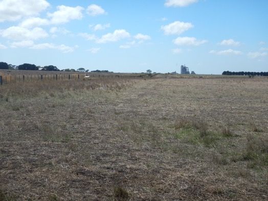
Figure 6 - Looking east from Bogans Lane across the site with Geelong-Warrnambool rail line on the right in
the image.
Figure 7 – Looking southwest along the existing rail line from Bogans Lane.
25Bushfire Assessment and Development Report for 255 Reservoir Road, Waurn Ponds
Figure 8 - Looking southwest from Reservoir Road showing Grassland in the Downslopes >0˚-5˚ class.
Figure 9 - Looking east across site from Pettavel Road with Geelong-Warrnambool rail line on left in image.
26Bushfire Assessment and Development Report for 255 Reservoir Road, Waurn Ponds
6 Planning and development response
Note that the findings and recommendations of this section relate to both Stage 1 and Stage 2 of the
project.
6.1 Development response
6.1.1 Building compliance
The project involves the construction of several buildings and facilities for the maintenance and
servicing of trains (see Map 3), including:
• Maintenance facility (shed) (50m x 250m x 10m);
• Operations administration and train crew facilities;
• Furling facility (160m x 25m x 5.5m);
• Train wash (50m x 10m x 12m);
• Train biowash (50m x 10m x 12m);
• Fuel tanks (6.5m diameter x 3.5m), waste oil storage and other fuel storage;
• Sanding tank;
• Water tanks;
• Substation; and
• Car parks
Upon completion, approximately 40 staff will be onsite during operating hours and during
construction up to approximately 100 site occupants.
In Bushfire Prone Areas (BPAs), the Building Act 1993 and associated Building Regulations 2018,
through application of the National Construction Code (NCC), require bushfire protection standards
for class 1, 2 and 3 buildings, ‘Specific Use Bushfire Protected Buildings’ and associated class 10a
buildings or decks. Applicable buildings must be constructed to a minimum Bushfire Attack Level
(BAL)-12.5, or higher, as determined by a site assessment or planning scheme requirement.
Each BAL construction standard represents a safety threshold for Radiant Heat Flux exposure (RHF,
expressed as kw/m2). The distance to achieve a desired RHF threshold is calculated from inputs
including the presumed weather conditions, vegetation type and slope i.e. a BAL-12.5 building is
designed to be exposed to not more than 12.5kw/m2 RHF, for which, in response to flat or upslope
Grassland, a 19m building setback is required.
There will be no accommodation component to any building on the site, and therefore none of the
proposed buildings would be class 1, 2 or 3 buildings, associated class 10a buildings or decks or
‘Specific Use Bushfire Protected Buildings’. Accordingly, a BAL construction standard for the
buildings is likely not required for building compliance. However, the classification of the buildings
and hence BPA compliance, will need to be confirmed by the building surveyor having authority.
27Bushfire Assessment and Development Report for 255 Reservoir Road, Waurn Ponds
Although a BAL construction standard is not technically required by the building regulations, due to
the building type and proposed use, it would be prudent, as a precautionary safety measure that
shows protection of human life is being prioritised, to consider constructing key buildings to the
minimum BAL-12.5 standard that applies in the BPA. This approach might be considered only for
those buildings that would be occupied periodically by staff and contractors i.e. habitable buildings
(see Map 3) or buildings of value, where their loss in a bushfire may severely impact the operation of
the site.
6.1.2 Other structures and infrastructure
The vulnerability of other structures and infrastructure on the site to bushfire attack (including
radiant heat flux, smoke, strong winds, embers and possible flame contact) should be considered, as
without adequate vegetation management, or non-vegetated land around them, they may be
exposed to damaged or destroyed in the event of a grassfire impacting the site.
No information has been provided to Terramatrix on the vulnerability of rolling stock to fire. Trains
may have exposed and vulnerable features such as hydraulic lines and electrical fittings. Similarly,
the substation and outdoor fuel storage areas are potentially vulnerable elements of the facility.
It is recommended that RPV assess the value of assets and consider the need to protect them from
bushfire attack. Where appropriate, tailored bushfire mitigation measures can be put in place to
minimise their loss. The CFA requested that their State Infrastructure and Dangerous Goods Team be
engaged during the building design phase to advise on structural fire safety (Luke, 2017). The type of
treatment would be based on their vulnerability to bushfire attack (flame, radiant heat, ember attack
or smoke) and may include options such as vegetation management, shielding, ember proofing or
simple housekeeping measures. Table 5 presents a list of RHF thresholds to people and building
elements.
Table 5 – RHF thresholds (Source: Standards Australia, 2011)
Phenomenon kW/m2
Pain to humans after 10 s to 20 s 4
Pain to humans after 3 s 10
Ignition of cotton fabric after a long time (piloted4) 13
Ignition of timber after a long time (piloted) 13
Ignition of cotton fabric after a long time (non-piloted5) 25
Ignition of timber after a long time (non-piloted) 25
Ignition of timber in 20 s (non-piloted) 45
4 Introduction of a small flame to initiate ignition
5 Flame not introduced to initiate ignition
28Bushfire Assessment and Development Report for 255 Reservoir Road, Waurn Ponds
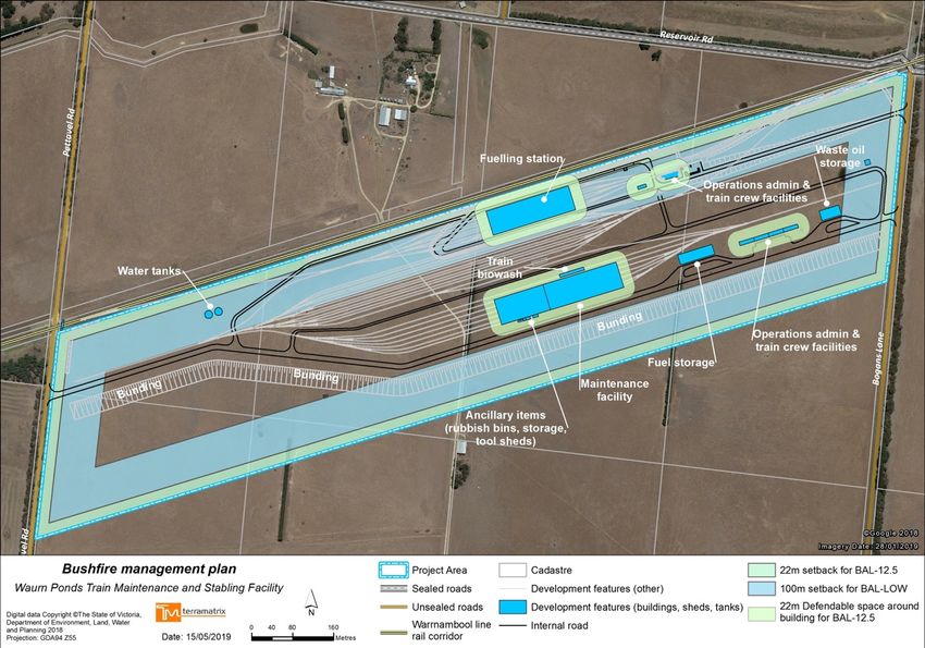
Map 3 – Bushfire management plan showing potential vegetation management zone.
29Bushfire Assessment and Development Report for 255 Reservoir Road, Waurn Ponds
6.1.3 Vegetation management
If a BAL-12.5 (or other RHF threshold) is to apply to any building or other asset, a minimum area of
non-vegetated land or ‘low threat’ vegetation (e.g. grass mown to less than 100mm high) will be
required to be maintained around that asset during fire season.
For BAL-12.5 buildings exposed to Grassland on flat land, the required setbacks are a minimum 19m
separation. For Grassland in the ‘Downslopes >0˚-5˚’ class, the applicable BAL-12.5 distance is 22m.
For illustrative purposes only, Map 3 shows the extent of a 22m defendable space around each
building. Although it is recommended that the entire site will be managed in a low threat state, this
defendable space represents the minimum area required around buildings built to BAL-12.5. Any
landscaping within the defendable space area should aim to meet the standards for defendable
space detailed in Appendix 2.
Analysis of the Landscape and Visual Impact Assessment and discussions with AECOM, indicate this
will be achievable, but a more detailed landscape plan is required to confirm propose plantings can
be considered ‘low threat’.
6.1.4 Access and Water
As per the CFA letter of advice (Luke, 2017), the site provides an internal road with access points on
both Pettavel Rd and Bogans Rd. Minor roads come off the main access route and run between the
existing mainline and the new lines, and between the stage one and stage two stabling roads (see
Map 3) to encircle the major infrastructure on the site.
Providing at least two ways in and out of a site is a long-standing principle for bushfire safety, to
ensure there are options for evacuation for both site occupants and emergency services. All roads
will be at least 3.5m in width and constructed of non-flammable materials. Given the size of the site,
it is also recommended that passing areas and turning circles as per CFA specifications for BMO
compliance (detailed at Appendix 3) are provided.
A static water supply for fire-fighting is not a requirement under the planning or building provisions
however, as a precautionary approach, it is recommended a static supply be provided that (as a
minimum) complies with the BMO requirements for static water, as detailed in Appendix 4. This
should be a static water supply of at least 40,000L capacity provided and maintained solely for
firefighting purposes and provided with CFA fittings and access. Map 3 shows the location of a
proposed static water supply (capacity unknown).
6.1.5 Preventing ignition and fire spread onsite
Activity on the site may result in an ignition which, under elevated fire weather conditions, may
spread beyond the property boundaries. The likelihood of an ignition can be reduced by applying
some (or all) of the following actions:
30You can also read