Copthorne Neighbourhood Plan 2021 2031 - Regulation 15 Submission Version February 2021 - Mid Sussex District Council
←
→
Page content transcription
If your browser does not render page correctly, please read the page content below
Copthorne
      Neighbourhood Plan
             2021 – 2031

               Regulation 15 Submission Version

1                                February 2021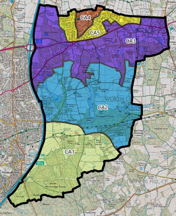
t for Regulation 14 Consultation

    Foreword
    The Localism Act 2011 gave Parish Councils the option to create a Neighbourhood Plan which
    would become part of the Development Plan and be used to determine planning applications.
    Worth Parish Council grasped the opportunity and decided to create 2 Plans, one for each Ward
    within its boundaries.
    Over the last 8 years, Parish Councillors and residents have spent many thousands of volunteer
    hours preparing this plan, consulting with our community and attending training sessions. We are
    extremely grateful to everyone who has been part of this process, whether you have been on the
    Steering Group or simply responded to one of our consultations.
    This plan provides a clear vision for Copthorne Ward, based on what we have learnt from the
    community. Whilst it does not address housing development, it does address important issues
    locally such as heritage, our open spaces, character and parking and we hope that the community
    will support it moving forward and becoming part of the Development Plan for the area.
    Councillor Chris Phillips
    Chairman of the Copthorne Neighbourhood Plan Steering Group

2
TABLE OF CONTENTS                                                                                                                       8.    OUR ECONOMY ................................................................................28

                                                                                                                                        9.    TRAFFIC & TRAVEL ..........................................................................30
1.   INTRODUCTION ................................................................................ 5
                                                                                                                                                Sustainable Transport.................................................................................... 31
       Evolution of this document ........................................................................... 5
                                                                                                                                                Car Parking ........................................................................................................ 33
       How This Document Should Be Used ........................................................ 5
       Planning Policy Context .................................................................................. 6                     10. POLICIES MAP ..................................................................................37

2.   VISION & OBJECTIVES...................................................................... 7                                        11. EVIDENCE & RESOUCES ..................................................................42
       Copthorne in 2031 ............................................................................................ 7                 12. GLOSSARY & ACRONYMS ...............................................................43
       Plan Objectives ................................................................................................... 7

3.   ABOUT COPTHORNE WARD ............................................................ 8
       Origins ................................................................................................................... 8
       Development ....................................................................................................... 8
       Future ..................................................................................................................... 9

4.   GENERAL POLICIES ......................................................................... 10
       General Development Requirements....................................................... 10
       Redevelopment and infill in the Built-Up Area .................................... 11
       Homes for older people ................................................................................ 12

5.   COMMUNITY RESOURCES .............................................................. 13
       Important Community Facilities................................................................. 13
       Public Houses.................................................................................................... 14
       Assets of Community Value......................................................................... 15
       Local Green Space ........................................................................................... 16

6.   THE HISTORIC ENVIRONMENT...................................................... 17

7.   CHARACTER AREAS ........................................................................ 18
       CA1: High Weald AONB ................................................................................ 19
       CA2: Agricultural Belt ..................................................................................... 20
       CA3: Copthorne Common and Woodland............................................. 22
       CA4: Historic Core ........................................................................................... 24
       CA5: Post War Copthorne ............................................................................ 26
                                                                                                                                                                                                                                                                      3
TABLE OF POLICIES                                                                                      FIGURES
             GENERAL DEVELOPMENT REQUIREMENTS ......................... 10                             FIGURE 1 - THE BUILDING REGULATIONS 2010 APPROVED
                                                                                                                  DOCUMENT M ....................................................................12
        REDEVELOPMENT AND INFILL DEVELOPMENT WITHIN THE
DEFINED BUILT UP AREA. ..................................................................... 11        FIGURE 2 – THE PRINCE ALBERT PUB, A REGISTERED ASSET OF
                                                                                                                   COMMUNITY VALUE ..........................................................14
             HOMES FOR OLDER PEOPLE ................................................. 12
                                                                                                       FIGURE 3 – COPTHORNE CARNIVAL, AN ANNUAL EVENT HELD ON
             IMPORTANT COMMUNITY FACILITIES ................................ 13                                    THE VILLAGE GREEN..........................................................16
                                                                                                       FIGURE 4 – MAP OF OUR CHARACTER AREAS .....................................18
             CONVERSION OF PUBLIC HOUSES....................................... 14
                                                                                                       FIGURE 5 – ENCLOSED FOOTPATH WITHIN THE WOODED AREAS OF
             ASSETS OF COMMUNITY VALUE .......................................... 15                               THE CA1 ..............................................................................19
             LOCAL GREEN SPACE ............................................................ 16         FIGURE 6 – VEHICULAR ACCESS PROVIDED BY FARM TRACKS IN CA2
                                                                                                                   .............................................................................................21
             PARISH HERITAGE ASSETS ................................................... 17
                                                                                                       FIGURE 7 – VIEW OF COPTHORNE GOLF CLUB ....................................22
             CA1: HIGH WEALD AONB ..................................................... 19
                                                                                                       FIGURE 8 – ST JOHNS CHURCH, LOCATED IN THE HISTORIC CORE
             CA2: AGRICULTURAL BELT ................................................... 20                         (CA4) ...................................................................................25

             CA3: COPTHORNE COMMON AND WOODLAND ............... 22                                     FIGURE 9 – REPEATING STYLES OF BUILT FORM ALONG ERICA WAY
                                                                                                                   (CA5) ...................................................................................27
             CA4: HISTORIC CORE............................................................. 24        FIGURE 10 – REPEATING STYLES OF BUILT FORM ALONG OAK CLOSE
             CA5: POST WAR COPTHORNE.............................................. 26                              (CA5) ...................................................................................27
                                                                                                       FIGURE 11 – TAKEAWAY BASED IN CAPTHORNE ...............................28
             OUR ECONOMY ...................................................................... 29
                                                                                                       FIGURE 12 – LOCAL ESTATE AGENTS BASED IN COPTHORNE ...........28
             SUSTAINABLE TRANSPORT .................................................. 32
                                                                                                       FIGURE 13 – THE BUSY ROAD JUNCTION OF COPTHORNE BANK &
             CAR PARKING ........................................................................ 34               BROOKHILL ROAD .............................................................30

             NEW PARKING AREAS .......................................................... 35           FIGURE 14 – WHERE A FOOTPATH JOINS THE A264 NEAR THE
                                                                                                                   COPTHORNE HOTEL, THE PRIMARY ROAD ROUTE
                                                                                                                   THROUGH THE PLAN AREA..............................................31
                                                                                                       FIGURE 15 - AIRPORT RELATED PARKING RECENTLY CONSTRUCTED
                                                                                                                   IN THE PLAN AREA. ...........................................................33
                                                                                                       FIGURE 16 – ON-STREET PARKING ALONG CHURCH LANE ...............34

4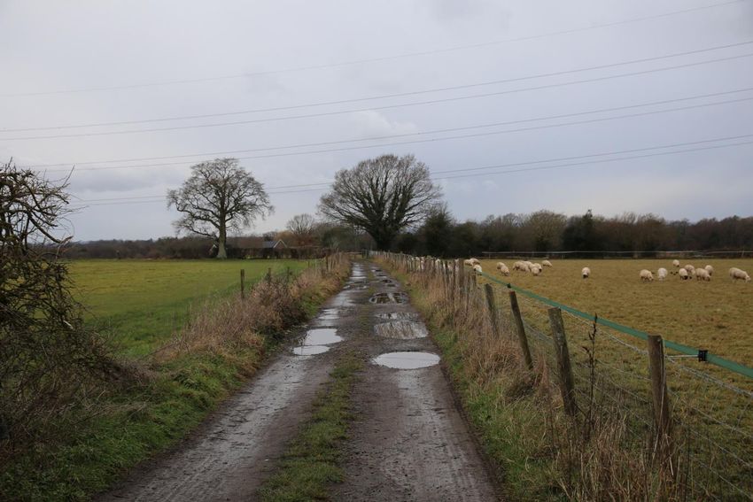
1.       INTRODUCTION                                                      Neighbourhood Plan Committee with separate sub-
                                                                           committees for each village. Later the formal committee
         Welcome to the Copthorne Neighbourhood Plan. This                 preparing this plan would become a Steering Group to
         document provides one part of the development plan for            afford them more flexibility when preparing this document.
         Copthorne Ward to 2031. It sits alongside the Mid Sussex
                                                                           This Neighbourhood Plan is based on substantial
         District Plan 2014-2031 (and other documents) and is used
                                                                           consultation with the local population to identify and
         to guide development and determine planning applications
                                                                           develop solutions for key local issues. It covers the period to
         within the Plan Area.
                                                                           2031, aligning with the current Mid Sussex District Plan, and
         The Copthorne Neighbourhood Plan has been prepared in             sets out a clear vision for the future of Copthorne together
         accordance with the Town & Country Planning Act 1990, the         with the policies and proposals to realise this vision.
         Planning & Compulsory Purchase Act 2004, the Localism Act
                                                                           Those working on the Plan have ensured that it has been
         2011 and the Neighbourhood Planning Regulations 2012.
                                                                           prepared in close consultation not just with our own
         The plan covers Copthorne and Worth Ward (hereafter               community, through village public events, but with the
         referred to as the ‘Plan Area’) of Worth Parish. The Plan Area    Crawley Down sub-committee, Worth Parish Council, Mid
         was formally designated by Mid Sussex District Council in         Sussex District Council and has remained cognisant of other
         July 2012. Since then, a Steering Group, working on behalf of     nearby neighbourhood plans so that over-arching issues
         the Parish Council, have worked to deliver a plan that            were considered.
         actively responds to the Communities’ aspirations.
                                                                           This final document has taken account of comments,
         For reference, the remainder of the Parish comprises Crawley      opinions and suggestions from all public consultations
         Down Ward, and this area has a separate neighbourhood             undertaken between 2013 and 2021.
         plan1.
                                                                           How This Document Should Be Used
         Evolution of this document
                                                                           This plan should be used by residents, local authorities and
         The early work on this Neighbourhood Plan was undertaken          developers and other stakeholders alongside other
         by a Steering Group comprised of Parish Councillors and           documents in the Development Plan to understand how
         local volunteers. In November 2013, Worth Parish Council          future development in the Plan Area should occur.
         formalised the arrangements by establishing a

1Details of all neighbourhood plans in Mid Sussex can be found online at
https://www.midsussex.gov.uk/planning-building/neighbourhood-plans/
                                                                                                                                             5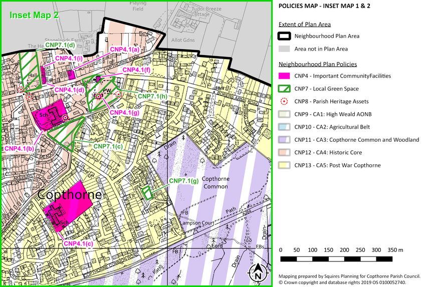
For applications that require planning permission, whether                           contained in any development plan that covers their area
        proposing a scheme or assessing the acceptability of a                               and states that:
        scheme, the policies contained within this document are a
                                                                                              29. Neighbourhood planning gives communities the
        key material consideration. For a planning application to be
                                                                                                  power to develop a shared vision for their area.
        considered favourably, all relevant policies contained within                             Neighbourhood plans can shape, direct and help
        this plan should be considered and complied with.                                         to deliver sustainable development, by influencing
                                                                                                  local planning decisions as part of the statutory
        Where development does not require planning permission
                                                                                                  development plan. Neighbourhood plans should
        the community would still like development proposals to                                   not promote less development than set out in the
        adhere to the aspirations and objectives set out within this                              strategic policies for the area, or undermine those
        document. It is however noted that this document only                                     strategic policies.
        controls development that requires planning permission.
                                                                                              30. Once a neighbourhood plan has been brought into
        Planning Policy Context                                                                   force, the policies it contains take precedence over
                                                                                                  existing non-strategic policies in a local plan
        The Localism Act 2011 introduced new rights and powers to                                 covering the neighbourhood area, where they are
        allow local communities to shape new development by                                       in conflict; unless they are superseded by strategic
        preparing Neighbourhood Plans. A Neighbourhood Plan                                       or non-strategic policies that are adopted
        establishes planning policies for the development and use of                              subsequently.
        land, for example where new homes should be built and                                The Development Plan for the Plan area comprises a number
        what they should look like. Neighbourhood Plans allow local                          of documents2, the principal one being the Mid Sussex
        people to influence the type of development for their area                           District Plan 2014-2031 which sets out the Districts strategic
        while contributing to the wider needs of the area.                                   and other planning policies intended to guide development
        The Government published the revised National Planning                               until 2031. At the time of writing this plan, Mid Sussex
        Policy Framework (NPPF) in February 2019. This sets out the                          District Council are progressing a Site Allocations DPD
        Government’s planning policies for England and how these                             (scheduled for adoption in Autumn 2021) which will allocate
        should be applied. It provides a framework within which                              sufficient housing and employment land to meet the
        locally prepared plans for housing and other development                             identified needs of the district.
        can be produced. The NPPF confirms neighbourhood plans
        must be in general conformity with the strategic policies
    2The current documents in the Development Plan can be found on the Mid Sussex District
    Council website at https://www.midsussex.gov.uk/planning-building/
6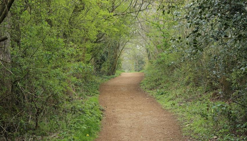
2.   VISION & OBJECTIVES                                               A) COMMUNITY
                                                                       Many live in Copthorne for the village life. This plan seeks to
     Copthorne in 2031                                                 reinforce our collective community spirit and enhance our vast array
                                                                       of community facilities, organisations and events.
     This plan sets a vision for the future of the parish and then
     how that vision will be realised through the use of policies
     contained in this document over the plan period to 2031.          B) HOUSING
                                                                       The housing needs of our local community should be met, whether
     This plan’s vision is:                                            that be through new housing coming forward or ensuring that our
                                                                       existing housing stock meets our needs,

       In 2031, Copthorne will be a thriving and attractive
         village community set in unspoilt and accessible
                                                                       C) ECONOMY
     countryside that provides an excellent quality of life for        We want to ensure that our local shops and businesses who serve
       residents, visitors, and those who work in, or travel           the local community are preserved. Many residents currently work
                         through, the area.                            outside of the plan area and we want to make it easier for them to be
                                                                       able to work here, without the need to travel to other settlements or
                                                                       locations for work.

     Plan Objectives                                                   D) ENVIRONMENT
                                                                       Our natural environment, including our countryside and green
     From the vision, five objectives have been derived from our       and open spaces will be safe from development for the benefit
     engagement with the local community and these are set out         of village life and local flora and fauna. Our built environment
     to the right.                                                     will be beautiful, diverse and sensitive.

     These objectives underpin the plan and have given rise to
     the individual policies in the following sections of this plan.   E) TRANSPORT
                                                                       We will seek to increase sustainable transport options, reduce
                                                                       the need to travel and reduce inappropriate vehicle parking.

                                                                                                                                               7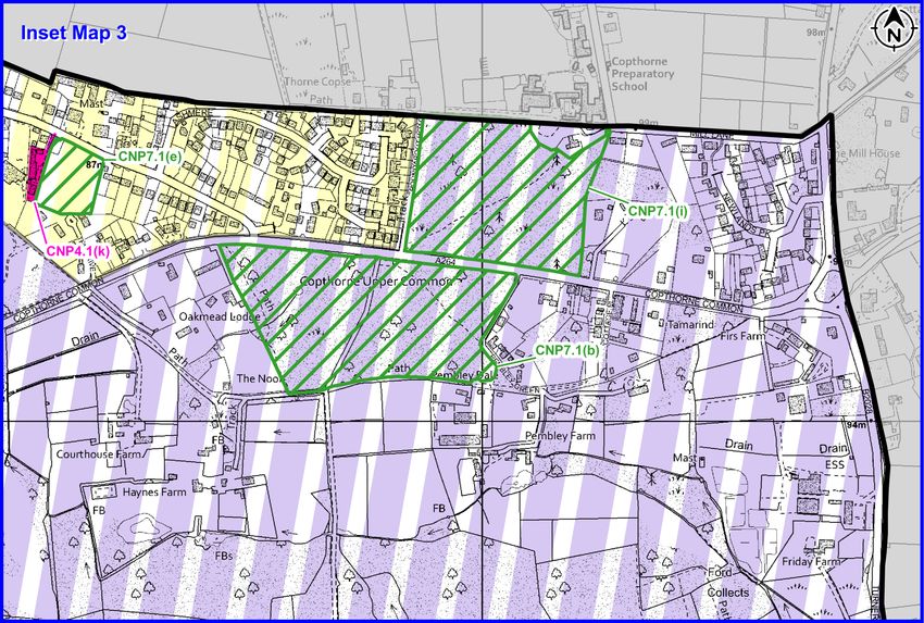
3.   ABOUT COPTHORNE WARD                                                in Surrey. To the east is countryside between the village and
                                                                         East Grinstead and to the west the boundary is the M23
     Copthorne is situated in the NE corner of West Sussex and at        motorway.
     the northern boundary of Mid Sussex District. The northern
                                                                         Development
     boundary of the built-up area of Copthorne abuts the green
     belt of Surrey. The village lies 3 miles east of Crawley, 4 miles   From the 16th century, in addition to farming, the prosperity
     west of East Grinstead and 4 miles to the south east of             of the area was due to a thriving iron foundry industry which
     Gatwick Airport. The built up area of the village is at the         was common throughout Sussex. A furnace was operated at
     most northerly part of the ward. The areas to the south of          Rowfant Mill from 1600 to 1664. In the late 17th century it
     the built up area are mainly woodland and farmland                  was discovered that coke could be used for smelting iron
     including a large Area of Outstanding Natural Beauty.               and Rowfant Mill only ceased operations in 1930.

     Origins                                                             The introduction of the railway line from Three Bridges to
                                                                         East Grinstead in 1841 was the catalyst for the first wave of
     Copthorne was mentioned in the Domesday Book when it
                                                                         housing in the village and the centre of the village can still
     was called Copedorme. The earliest mention of Copthorne
                                                                         be identified by the 19th century houses and cottages that
     was in 1617. In the 16th century Copthorne’s prosperity was
                                                                         were built. The Copthorne Elementary School (now the
     influenced by a thriving iron foundry industry with a furnace
                                                                         Copthorne Church of England Junior School) was built in
     operated at Rowfant Mill which remained in operation until
                                                                         1842 to service the expanding village population. The village
     1930.
                                                                         church of St. John was built in the 1870’s at a cost of £3,500
     In the 19th century the village had 18 farms providing              as a result of a gift from a local wealthy landowner.
     sustenance to the surrounding area. Because of its proximity
                                                                         From 1950, the expansion of Crawley and Gatwick Airport
     to the coast and the fact that the village straddled the
                                                                         and the related employment saw the building of small
     county boundary, Copthorne was renowned for smugglers,
                                                                         estates on the edge of the old village and the loss of some
     poachers and prize fighters. In 1810 a famous world title
                                                                         of the farmland. By 2000 the number of dwellings in the
     prize fight took place in Copthorne between Tom Molinezux
                                                                         village had increased to 1700. Currently the Neighbourhood
     and an American Tom Cribb. The fight ring is still visible
                                                                         Plan area has 1850 dwellings after more small-scale
     among the woodland to the south of the A264.
                                                                         developments filling some of the remaining sites and
     Copthorne village is surrounded by large areas of                   replacing some small industrial sites. This has increased the
     countryside. To the south there is an Area of Outstanding           population of Copthorne to 5,500. During this period a
     Natural Beauty and to the north is an area of Green Belt land
8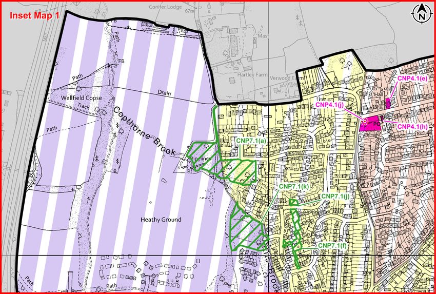
further school was built in the village which is now           Future
Copthorne Infant School.
                                                               In the next few years, the number of dwellings in Copthorne
Copthorne Village originally straddled the county              will be increased by 30% after the approval of 550 new
boundaries of Surrey and Sussex, but as a result of Boundary   houses to the west of the village, between the existing
Commission revues in 1974 and 1992 most of the village was     village boundary and the M23 Motorway. The larger
moved into Sussex, leaving 2 small stretches of road to the    development at Heathy Wood is expected to be completed
north of the village in Shipley Bridge Lane and Copthorne      over the next 5 years. These developments will put a strain
Bank in Surrey, The stretch of Copthorne Bank in Surrey        on the existing overstretched resources of the village and it
contains the main sports facility for the village and the      is to be expected that there will be some expansion of the
allotments used by villagers.                                  schools, doctors surgery and sport and recreation facilities to
                                                               cope with the increased population. Also, the road network
The main built up area of Copthorne has a natural southern     is at full capacity and more at peak times, and action will be
boundary in the A264 and to the north is the County            needed to mitigate the increased usage as a result of the
boundary with Surrey and the Green Belt. To the west, the      new housing.
new development on Heathy Wood takes the village
boundary to the M23 motorway. To the east, the built-up        The big challenge for the village will be to achieve this
area of the village ends where Borers Arms Road runs into      expansion while retaining the village atmosphere which is a
Copthorne Road.                                                primary reason for people wishing to live in the village.

                                                               Beyond the already approved expansion, it is to be hoped
                                                               that future development will be on a small scale within the
                                                               existing built area and the countryside which surrounds the
                                                               village will be preserved for the enjoyment of local people,
                                                               and the Neighbourhood Plan has been draw up to achieve
                                                               this aspiration.

                                                                                                                              9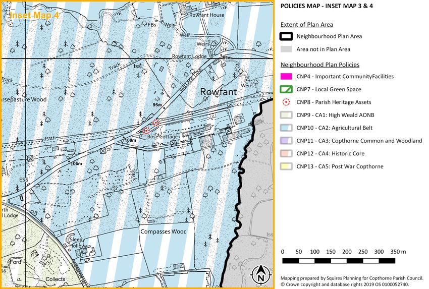
4.       GENERAL POLICIES                                                                  Character Area3, as defined on the Policies Map, in
                                                                                            which they sit.
          This section provides general policies to guide development
                                                                                            Proposals for new development should not cause
          within the Plan Area. The intention is to introduce a locally
                                                                                            unreasonable harm to the amenity (including general
          specific level of detail to planning policy that is currently not
                                                                                            activity, access, noise, privacy, daylight, and sunlight)
          addressed in the District Plan.
                                                                                            of existing and future occupants, both on site and
          General Development Requirements                                                  nearby.
                                                                                            Proposals should retain features such as shaws,
          This policy ensures the overarching views of our local
                                                                                            hedgerows, ponds and brooks, and enhance them,
          community are considered when designing proposals and
                                                                                            where possible.
          determining applications. Key matters include:
                                                                                            Proposals should protect, and encourage the use of,
             • Maintaining Copthorne’s identity as a village.                               pavements, pathways, footpaths, cycle paths,
                                                                                            bridleways, established tracks and twittens, and other
             • Ensuring the amenity of properties is maintained.
                                                                                            Rights of Way.
             • Retaining our rural environment.                                             Development proposals should be laid out to
                                                                                            maintain the perception of separation between
             • Supporting the uptake of non-motorised travel, to help                       Copthorne Village and other surrounding settlements.
               our environment and reduce traffic on our roads.
                                                                                            Extensions to existing buildings will be permitted
                                                                                            provided they adhere to other policies in the
                                                                                            development plan and:
                General Development Requirements                                                 Are no higher than the existing building.
                                                                                                 Do not conflict with traditional boundary
                Proposals will be supported where they sustain or                                treatment of an area.
                reinforce the positive aspects that make up the                                  Use materials which are compatible with
                individual character and distinctiveness of each                                 materials of existing/surrounding buildings.

      3
       Details for each Character Area is set out in Policies CNP9, CNP10, CNP11, CNP12 &
      CNP13. Further guidance is also set out in the Copthorne Heritage and Character
      Assessment May 2019 or subsequent updates to this document.
10
Redevelopment and infill in the Built-Up Area
Redevelopment and infill development within the
Broadly speaking, infill is the development of a relatively defined built up area.
small gaps between existing buildings and redevelopment is
any new construction on a site that has pre-existing uses. Redevelopment and infill development is supported
These types of development are considered appropriate in within the defined built up area4 subject to meeting
principle as they are usually in a sustainable location, being the following criteria:
relatively accessible and already served by public The new development will not appear
infrastructure. incongruous with the existing character and/or
street scene, ensuring the proposed materials,
The District Plan confirms in DP6: Settlement Hierarchy that
plot size, boundary treatment, built form,
‘development will be permitted within towns and villages
building line and gaps between buildings is like
with defined built-up area boundaries. infilling and
those around it.
redevelopment will be required to demonstrate that it is of
an appropriate nature and scale (with particular regard to Suitable access and on-site parking are provided
DP26: Character and Design), and not cause harm to the without detriment to neighbouring properties,
character and function of the settlement.’ pavements, pathways, footpaths, cycle paths,
bridleways, established tracks, twittens, and
The policy below adds additional local detail to this policy to other Rights of Way.
ensure that infill and the redevelopment of sites is Does not cause unreasonable harm to the
appropriate within the defined built up area of Copthorne. amenity of existing and future occupants, both
This policy addresses proposed development within the on site and nearby by way of general activity,
built-up area. Proposal outside the built-up area will need to access, noise, privacy, dominance, daylight, and
conform with the criteria within DP6 of the Mid Sussex sunlight.
District Plan and other relevant policies contained within the
development plan.
4
The built up area boundary is defined by Mid Sussex District Council and set out in the adopted
development plan. At the time of writing the relevant document is the Mid Sussex District Plan 2014-
2031.
11Homes for older people requirement. The social benefits of this standard are
significant.
Through our engagement with the community, a significant
issue has been identified, which is the lack of suitable
Homes for older people
housing for older people. There is a trend for single storey
properties (such as bungalows) that provide suitable
accommodation for the elderly having a second floor added. Development proposals that would result in the net
This turns what are generally smaller single level properties loss of single storey residential floorspace5 will be
into larger family homes. refused.
Major development6 incorporating residential
This has led to a reduction in suitable accommodation for dwellings must include smaller and accessible homes
the older members of our community. This is likely to be that meet the needs of older people .
exacerbated via the recent introduction of permitted
In addition to the requirements of Policy DP28 in the
develop rights allowing the addition of an additional storey
Mid Sussex Local Plan, all new dwellings (regardless
to an existing single storey property or a bungalow.
of size, type or tenure) should achieve a minimum of
Whilst permitted development rights undermine the M4(2) of the optional requirements in the Building
objective of CNP3.1 they do not apply when planning Regulations, unless it can be demonstrated that to do
permission is required. This policy therefore seeks to do so would make the proposal unviable.
what it can to address this issue when an application is
required. This will be achieved by requiring no net loss of
single storey residential floorspace and making sure new
housing is a suitable size, and is accessible and adaptable to
meet the needs of older and disabled people. Figure 1 - The Building Regulations 2010 Approved Document M
To this end, the plan specifically includes a requirement to
meet the optional M4(2) standard. This objective is
supported by the recent MHCLG consultation “Raising
accessibility standards for new homes” which suggests that
all new homes should meet M4(2) as a minimum
5
‘single storey residential floorspace’ includes the GIA of accessible residential properties 6
As defined by The Town and Country Planning (Development Management Procedure) (England)
which are contained on a single level of a building. This will generally include, for example, Order 2015. Definition included in Glossary.
flats accessible by lifts and bungalows.
125. COMMUNITY RESOURCES Important Community Facilities
Many residents live in the Plan Area for the ‘village life’.
The following facilities, as identified on the Policies
Copthorne has a vast array of community resources, these
Map, are designated as Important Community
include the buildings in which we meet, our shared spaces
Facilities:
and the services on offer by private, public and charitable
Copthorne Surgery
groups.
Copthorne C of E Junior School
Our community have confirmed that we would like to Fairway Infant School
preserve community facilities within the Plan Area, to ensure Copthorne Village Hall
that they remain within walking/cycle distance and available
Delmar Morgan Centre
to the community.
Copthorne Parish Hub
Important Community Facilities St John the Evangelist C of E Church
Copthorne Post Office
Through our consultation activities, and most notably the
Copthorne Social Club
village survey undertaken in 2019, we have identified the
community facilities which are most important to the local The Prince Albert Public House
community. A detailed explanation of the identification Copthorne Scout & Guide Centre
process is set out in the document titled ‘Important Development proposals that would result in the loss
Community Facilities’ which is included in the evidence that of an Important Community Facility (whether that be
supports this plan. the actual facility/building or the use of the
facility/building), should be refused unless it can be
This policy identifies those facilities and seeks to ensure that
demonstrated that the use and building is no longer
they are not lost due to development or change of use and
required.
that facilities are safe and accessible by foot and cycle. This
means facilities that are easily accessed (within a reasonable Proposals that would involve the Important
walking and cycling distance from its users) and that there Community Facility being relocated to elsewhere
are footpaths to the facility that are well lit and in good within the Plan Area may be considered acceptable
condition. where the new location is easily and safely accessible
by foot or cycle.
13Public Houses
A concern locally is that the gradual loss of public houses
across the country will be replicated within the Plan Area.
The Plan Area only has one public house remaining and
therefore policy CNP5 seeks to ensure that it is only lost in
exceptional circumstances.
Conversion of public houses
Proposals which would result in the loss of a public
house will not be permitted unless it can be
demonstrated that the existing use is no longer
viable.
If it can be demonstrated that the existing use is not
viable the applicant must demonstrate that the
applicant has sought to use the site for another Figure 2 – The Prince Albert Pub, a registered Asset of Community Value
community use before considering other uses (such
as residential). Other community uses could include
combining the public house function with that of a
shop, post office, bed and breakfast or self-catering
facility.
14Assets of Community Value
Assets of Community Value
Part 5 Chapter 3 of the Localism Act 2011 provides for a
scheme called ‘assets of community value’. This requires Development proposals affecting an asset of
district and unitary councils to maintain a list of ‘community community value will be supported where it can be
assets’. It has also become known as the ‘community right to demonstrated that the development will not
bid’. adversely affect the benefits that the asset provides to
the local community or the reasons why the land was
Community assets can be nominated by Parish councils or
nominated to be of community value
by groups with a connection to the community. Individuals
cannot nominate community assets. If the nomination is
accepted, local groups will be given time to come up with a
bid for the asset when it is sold.
The right to bid only applies when an asset’s owner decides
to dispose of it. There is no compulsion on the owner to sell
it. It is not a community right to buy the asset, just to bid.
This means that the local community bid may not be the
successful one.
However, the legislation only has effect when the owner of
an Asset of Community Value wishes to sell their
land/building. Should an owner wish to redevelop or change
a nominated community asset there is nothing in the
planning system that would protect the community
connection or reason for its nomination.
This policy provides guidance to decision makers on
development proposals that would impact a local
community asset. This plan seeks to protect Assets of
Community Value for their community value.
15Local Green Space
The following areas, as identified on the Policies Map,
are designated as Local Green Space:
Westway designated green space area
Copthorne Common
Village Green
Copthorne recreation ground and skate park
Humphreys Field
Figure 3 – Copthorne Carnival, an annual event held on the Village Green Erica Way Open Space
Pinetrees Green Space
Local Green Space St John’s Churchyard
Woodland East of Copthorne Common Road
Open spaces may be designated as Local Green Space where
they are demonstrably special to the local community. To be Open Space North of Bridgelands
designated as Local Green Space, an area should meet the Kits Brook Woodland & Pedestrian Corridor
criteria set out in paragraph 100 of the National Planning There will be a presumption against all development
Policy Framework. on Local Green Space except in very special
circumstances. Such circumstances could include:
The Local Green Space designation is a way to provide
The proposal is of a limited nature and it can be
special protection against development for green areas of
clearly demonstrated that it is required to
particular importance to local communities. To be
enhance the role and function of an identified
designated they must be demonstrably special to the local
Local Green Space; or
community and hold a particular local significance, for
example because of its beauty, historic significance, The proposal would result in the development
recreational value (including as a playing field), tranquillity of local community infrastructure and be of an
or richness of its wildlife. The Steering Group have appropriate and limited nature, so as not to
conducted an extensive review of open spaces in the Ward prevent the use, role and function of the local
and whether they should be designated as Local Green green space.
Space. The full assessment document is included within the
Evidence Base.
166. THE HISTORIC ENVIRONMENT Parish Heritage Assets
The community recognises the importance of heritage assets
Development proposals will be supported where they
and the contribution they make to the quality of the area.
protect and, where possible, enhance Parish Heritage
Many assets are already designated and given protection by
Assets as identified on the Neighbourhood Plan
national planning policy and legislation as well as policies
Policies Map. The Parish Heritage Assets are:
contained within the wider Development Plan. There is no
Rowfant Station
need to reiterate these protections within this plan.
Rose Cottage (formerly Rowfant Station House)
However, also within the Plan Area are buildings which, The Prince Albert Public House
while not listed, are significant locally and are important Church of St John the Evangelist
features in their own right; and which also contribute to the
Lych Gate
character and appearance of the Plan Area.
Copthorne CE Junior School
An assessment (Local Heritage Assets (2020)) of our non- Claremont (former butcher’s shop)
designated heritage assets has been carried out to identify The Old Bakery
those structures considered to be locally valuable and
All proposals that directly impact Parish Heritage
important for their historic value. This policy designates our
Assets, or the setting thereof, must describe the
most significant non-designated assets as ‘Parish Heritage
impact of the development on the significance of the
Assets’ and gives them the protection they deserve.
heritage asset, demonstrating that the significance of
that asset will not be adversely impacted.
177. CHARACTER AREAS
Whilst the Plan Area is not vast, it does contain a number of
distinctly different areas that all have their own character.
From engagement with our community we believe there is a
strong desire for the character of these distinct areas to be
protected and reinforced wherever possible.
To inform this plan evidence7 has been prepared to
investigate and identify the distinct character areas of the
Plan Area. This evidence not only identifies the distinct
Character Areas8 (CA) but also why those areas are
distinctive.
It is recognised that the character of areas change over time
and this evidence, and the policies in this section, will be
revisited alongside any future review of this neighbourhood
plan.
This section provides policy support for development that
makes a positive contribution to the character of the Plan
Area.
Figure 4 – Map of our Character Areas
7 The Copthorne Heritage and Character Assessment 8 As shown on the Policies Map.
18CA1: High Weald AONB
CA1: High Weald AONB
CA1 is defined by a gently undulating landform and limited
development consisting of occasional farmstead. The area is Development proposals must sustain or reinforce the
criss-crossed by forestry tracks and the Public Right of Way positive aspects that make up the individual character
(PRoW) network. Very few roads pass through the area and distinctiveness of CA1 (as shown on the Policies
although the western boundary is formed by the M23, Map. The positive aspects are:
creating a hard edge to it. That buildings are dispersed and generally rural
in character.
Primarily a wooded landscape, it comprises a mixture of
ancient woodland, ancient replanted woodland and blocks A good network of PRoWs including bridleways;
of plantation. There is also some agricultural land within the Predominantly rural land uses absent of
northern part of CA1, containing a mixture of arable and urbanised areas;
pastoral agricultural fields. A variety of habitats including scrub, woodland,
ponds and streams, with mature specimen trees
Views are typically constrained by the dense woodland with in agricultural fields;
occasional views across agricultural fields and undulating
Dense woodland lining the M23 that acts as a
landscape of wooded horizon. That said, lines of pylons
buffer, protecting the wider CA from visual and
cross the landscape interrupting the otherwise naturalistic
noise effects or the motorway and Crawley to
character.
the west.
Certain types of development may alter one or more
positive aspects that make up the Character Area. This
is acceptable if its overall character and role is not
compromised and measures are taken to limit any
impacts through mitigation, and where possible,
enhancement. For example, this may be the
strengthening of other positive aspects of the area’s
character or general enhancement to the area
through increased biodiversity, green links and other
mitigation measures.
Figure 5 – Enclosed footpath within the wooded areas of the CA1
19CA2: Agricultural Belt
The cluster of commercial operations at Worth Hall is
incongruous with the overarching rural character of CA2 is defined by historic farmsteads which are scattered
the area. Proposals for additional built form should across an agricultural and wooded landscape. There is a
incorporate appropriate vegetation/screening to sense of tranquillity due to the limited road network and
enhance the wider rural character. sparse development.
Proposals that would result in the loss of or change of The irregular agricultural fields are defined by well-
use of rural buildings or farmsteads to commercial or maintained hedgerows interspersed with prominent
light industrial ventures should be avoided as these specimen trees. Most of the land and development contains
can degrade the overall rural character. remnants of the historic estate associated with Rowfant
Proposals must have regard to the objectives of the House. A number of millponds that have been formed
High Weald AONB Management Plan 2019-24. alongside minor watercourses flowing through the area.
Development must demonstrate that it meets
relevant elements of these objectives for this CA2: Agricultural Belt
nationally important landscape.
Development proposals must sustain or reinforce the
positive aspects that make up the individual character
and distinctiveness of CA2 (as shown on the Policies
Map). The positive aspects are:
The remnants of the former estate associated
with Rowfant House.
Network of PRoWs across the CA which includes
the Worth Way / Sussex Border Path;
Few public roads, agricultural land uses and
blocks of woodland creating a tranquil and rural
character.
The series of millponds located along
watercourses, and the suite recreational
activities these provide (such as fisheries).
20Consistent low density, high boundary
treatments and large front gardens of built
form.
Historic sunken lanes, such as Old Hollow.
Characteristically rural views from PRoWs from
within the CA including typical features such as
mill ponds, woodland and agricultural land.
Certain types of development may alter one or more
positive aspects that make up the Character Area. This
is acceptable if its overall character and role is not
compromised and measures are taken to limit any
impacts through mitigation, and where possible,
enhancement. For example, this may be the
strengthening of other positive aspects of the area’s
character or general enhancement to the area
through increased biodiversity, green links and other
mitigation measures.
Development proposals associated with existing
clusters of commercial development should
incorporate appropriate vegetation/screening to
enhance the wider agricultural character. Proposals
that would create new clusters of commercial
development should be refused.
Proposals which create or reinforce woodland along
the M23 will be supported as they will improve the
tranquillity and rural character of the area.
Figure 6 – Vehicular access provided by farm tracks in CA2
21CA3: Copthorne Common and Woodland
CA3: Copthorne Common and Woodland
As the name suggests, CA3 is primarily a wooded landscape
interspersed by irregularly shaped agricultural fields and Development proposals must sustain or reinforce the
common land. It is an area that is often referred to as positive aspects that make up the individual character
Copthorne’s ‘Green Ring’. and distinctiveness of CA3 (as shown on the Policies
Map). The positive aspects are:
It benefits from pl entiful public access afforded by
The large number of mainly 19th century
Copthorne Common, Pot Common and PRoW network
cottages attests to the area’s recent past and
providing accessible recreational resources to residents of
adds character to the area. The majority are kept
Copthorne.
in good condition and while amendments have
It is dissected by a key vehicular corridor providing access to been made the worst excesses of late 20th
the M23 from Copthorne, Crawley Down, East Grinstead and century home improvement have been avoided.
further afield. That said it has few urban land uses and those The larger properties have also been well kept
that do exist form clusters along its primary roads. which adds to the area’s character.
The extensive network of paths including the
long distance Sussex Border Path;
Figure 7 – View of Copthorne Golf Club
22The roundabout on Copthorne Common Road Proposals for commercial uses on the A2220 and
(A2220) acts as a node and a gateway to the A264 Copthorne Common Road or uses that serve the
settlement of Copthorne; nearby urban areas are incongruous with the
Large areas of woodland which have a high otherwise rural setting and should be refused.
degree of connectivity stretching across the CA Development proposals should actively seek to
west to east and have a rural character and reduce the severance caused by the primary roads
provide a sense of enclosure and tranquillity; (including the M23, A2220 and A264) by providing
Large areas of common land within the CA well improved pedestrian accessibility.
connected to the PRoWs and easily accessed
The suburban development on Newlands Park is not
from the surrounding settlements and feature
characteristic of this area and should not be
areas important for biodiversity;
considered a suitable design/style/layout cue for
Views typically are of rural landscapes; either of further development within this character area.
woodland or agricultural landscapes;
Development that would increase the presence of
Copthorne Common and rural areas
manmade features in views of agricultural landscapes,
surrounding Copthorne provide a verdant
such as pylons, agricultural vehicles or caravans
backdrop for the settlement; and
should be avoided.
The area of Copthorne Common within the
settlement envelope of Copthorne north of
Copthorne Common Road bringing green
infrastructure into the settlement
Certain types of development may alter one or more
positive aspects that make up the Character Area. This
is acceptable if its overall character and role is not
compromised and measures are taken to limit any
impacts through mitigation, and where possible,
enhancement. For example, this may be the
strengthening of other positive aspects of the area’s
character or general enhancement to the area
through increased biodiversity, green links and other
mitigation measures.
23CA4: Historic Core
particularly highlighted by the setting of the
At the centre of Copthorne it its historic core. This primarily church within its churchyard.
residential area has clusters of commercial activity along The boundary walls of historic large houses and
Copthorne Bank, Borers Arm Road and Church Road. It is their grounds.
interspersed with a number of historic buildings contributing Copthorne Brook is visible at the bottom of the
to a rich sense of place. village green.
The village green forms a key focus of the CA and short PRoWs which provide easy pedestrian access
footpaths, locally known as ’Twittens’, between residential through the settlement and the residential
streets increase pedestrian permeability across the area. The streets and further public rights of way which
pallet of materials most commonly used include red or link to a wider network outside the CA.
brown bricks and red roof and hung tiles with details A number of heritage assets are clustered along
including as red brick quoins or red brick bands surrounding the primary roads of the CA.
windows. Community features are focused around the
village green creating a social hub to the
CA4: Historic Core settlement.
Wide residential roads with an established
Development proposals must sustain or reinforce the rhythm and spacing of consistently sized
positive aspects that make up the individual character dwellings, vegetated front gardens and or front
and distinctiveness of CA4 (as shown on the Policies boundary treatments.
Map). The positive aspects are: Certain types of development may alter one or more
The large number of non-designated built positive aspects that make up the Character Area. This
heritage assets, mainly well maintained, which is acceptable if its overall character and role is not
contribute to the character of the village. compromised and measures are taken to limit any
Sensitive modern infill with the widespread use impacts through mitigation, and where possible,
of red brick achieving a blend of old and new. enhancement. For example, this may be the
strengthening of other positive aspects of the area’s
The ‘village feel’ resulting from the main urban
character or general enhancement to the area
area only being slightly suburbanised by
through increased biodiversity, green links and other
modern buildings. This ‘village feel’ is
mitigation measures.
24Shopfronts on Copthorne Bank and on Church Road
are dominant in the streetscape and detract from the
character of the CA and setting of undesignated
heritage assets. Shops should therefore adopt
traditional shop fronts when they are
altered/replaced.
To maintain the character of the area, proposals
should utilise traditional tile hanging rather than
timber (or faux) weatherboarding.
All proposals for new development should take great
care to avoid increasing street clutter (such as
overhead power / phone cables) and the urbanisation
of the CA (such as front gardens being converted to
driveways).
Figure 8 – St Johns Church, located in the Historic Core (CA4)
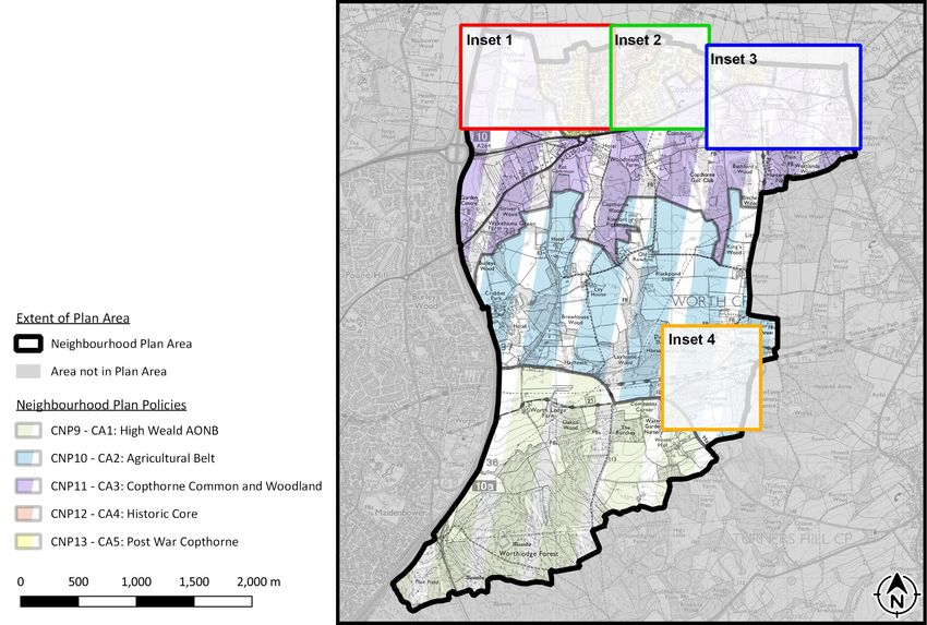
25CA5: Post War Copthorne
CA5: Post War Copthorne
CA5 contains the post war primarily residential expansion of
Copthorne. As a result it mostly comprises two storey, post- Development proposals must sustain or reinforce the
war housing with a suburban density of built form. It has a positive aspects that make up the individual character
regular structure to the residential developments of a and distinctiveness of CA5 (as shown on the Policies
singular loop of residential streets with many short cul-de- Map). The positive aspects are:
sacs. The larger properties, many of them built on
former farmland sold as building plots in the
The southern boundary of CA5 is defined by the hard edge
late 19th century indicate the popularity of the
provided by Copthorne Common Road (A264) which has few
area in the decades after the railway was built.
safe crossing points.
Built in differing styles they give a prosperous
Whilst there are several examples of heritage assets and pre- feel to the village.
war built form within the CA it generally consists of blocks of Roads with pavements and connecting footways
development with similar architectural styles that form providing good pedestrian accessibility and
localised character to individual streets. That said, one many intersecting PRoW’s providing great
common feature are green verges which can provide a permeability through the area.
pleasant street scene when they are not used for parking. Green verges lining our roads and streets.
Screening vegetation along most of Copthorne
Common Road (A264).
Open nature of residential streets.
Pockets of pre-war developments and
Areas of mature vegetation such as the river
corridor and the informal path between Calluna
Drive and Bridgelands.
Certain types of development may alter one or more
positive aspects that make up the Character Area. This
is acceptable if its overall character and role is not
compromised and measures are taken to limit any
impacts through mitigation, and where possible,
26enhancement. For example, this may be the
strengthening of other positive aspects of the area’s
character or general enhancement to the area
through increased biodiversity, green links and other
mitigation measures.
Proposals should seek to minimise negative impacts
resulting from additional traffic. In particular, green
verges should be protected from vehicles and
inappropriate parking. Where measures are put in
place to prevent parking on green verges, they should
adopt a consistent aesthetic.
Figure 10 – Repeating styles of built form along Oak Close (CA5)
Figure 9 – Repeating styles of built form along Erica Way (CA5)
278. OUR ECONOMY
Copthorne was traditionally a farming area with
smallholdings owned by prominent families whose financial
interests developed into transport and building, which then
evolved into the creation of several small industrial units still
let to local small businesses, often providing support and
technical services to the locale.
Alongside this local provision, the proximity of the Plan Area
to major road and rail links and its closeness to Crawley
Town, which includes very large and mature office and
industrial capabilities, has allowed Copthorne to emerge as a
prime commuter settlement with people generally leaving
the settlement where they live to find work.
Figure 11 – Takeaway based in Capthorne
Gatwick Airport also has a marked impact on the Plan Area
with several quality hotel and parking facilities within it, all
of them important employers. In the main, tho ugh, the local
economy is supported by income generated outside the
village boundary, or by self-employed traders serving the
community and by commuting from one of the three nearby
railway stations to major towns and cities.
Consultation activities to date have confirmed that there is
no strong local desire for Copthorne to become an
economic centre but that there is a drive to increase the
ability for home working and thus reduce commuting.
This plan therefore seeks to provide a degree of protection
to retain the shops and services and reduce the need for
commuting but stops short of encouraging new
employment-generating development.
Figure 12 – Local estate agents based in Copthorne
28It is recognised that under permitted development rights it
Our Economy
is now possible to change the use of a shop to certain other
uses such as offices or light industrial without applying for
planning permission. Whilst this may result in the loss of Development proposals that would result in the loss
shops which undermines this policy objective, it is of our shops and retail premises within the built-up
nevertheless important to seek to prevent their loss should a area boundary (as defined by Mid Sussex District
planning application be required. Council), are not supported and will only be
permitted in exceptional circumstances9.
Development proposals that would result in the loss
of employment floorspace/land will not be permitted
unless; it can be demonstrated that the on-going use
of the premises or land for employment purposes is
no longer viable.
Proposals for the provision of improved
telecommunication infrastructure are actively
encouraged and will be approved where they do not
have an unacceptable impact on residential amenity.
All new employment and commercial development
over 100sqm, residential development of one unit or
more, replacement residential development, and
buildings undergoing significant refurbishment, must
install Fibre to the Premises (FTTP) broadband
connection unless it can be demonstrated that it is
not viable to do so.
9It is for the decision maker to consider what comprises ‘exceptional circumstances’ in each case. into use or where the proposal includes the relocation of a shop / retail premises within the
Exceptional circumstances may include, but are not limited to, bringing an abandoned building back built-up area.
299. TRAFFIC & TRAVEL
The Plan Area faces a number of transport related problems
and this section seeks to address these as best it can.
The location of the Plan Area means that the village of
Copthorne sits at a bottleneck of the commuter rush-hour
congestion. The A264 at the Copthorne Hotel roundabout is
very congested and operating over capacity in both the AM
and PM peak hours. This level of congestion passing through
the Plan Area is compounded by the fact that many
residents are employed outside of the Plan Area and
therefore travel, often by car to work in Crawley, Gatwick,
and beyond.
The A264 effectively dissects the Plan Area and separates the
village of Copthorne from the countryside to the south. This
means that a vital resource for the health and wellbeing of
our community is beyond a major road with fast flowing
traffic and few safe crossing points.
A number of bus companies provide services between the
village and local centres such as Crawley, East Grinstead and
Haywards Heath. However, the timing of, and the routes
taken, by the bus services means that rail commuter journeys
must generally start and finish with a car journey. Whilst
increased bus services are supported it is accepted that this
plan has limited ability to impact this.
This Plan therefore seeks to increase sustainable transport
options where possible but also resolve other issues caused Figure 13 – The busy road junction of Copthorne Bank & Brookhill Road
by high private vehicle ownership.
30Sustainable Transport adopted Local Plans12, with the exception of Mid Sussex
District Council. As the closest Neighbourhood Plan area to
New development usually generates additional traffic and
Gatwick Airport in Mid Sussex, it is considered appropriate to
as highlighted in this Plan, there is already a significant issue addresses this matter.
with traffic congestion in the Plan Area. There is therefore a
need to increase the provision and use of sustainable
transport methods within the Plan Area and mitigate for the
impacts of new development. This policy provides the
support to achieve this.
The government has announced, in response to the Figure 14 – Where a footpath joins the A264 near the Copthorne Hotel, the
contribution vehicles make to climate change, that the sale primary road route through the plan area.
of petrol and diesel cars will cease by 2030. This policy
requires provision of car charging infrastructure which will
support and encouraging the decarbonisation of cars and
vans.
Passenger numbers at Gatwick Airport are forecast to grow
during the Plan period creating an additional need for
parking spaces. Placing these parking spaces away from the
airport is not sustainable, creating additional pressure on
local roads, and increasing CO2 emissions/air pollution and
may lead to the loss of countryside. As Gatwick Airport has
plans in place to provide sufficient parking spaces within the
airport boundary10 commensurate with a requirement to
meet a target of 48% of passengers travelling to the airport
by public transport11, on-airport provision is supported as it
is the most sustainable location for it. The local authorities
surrounding the airport have adopted this approach in their
10 Plans 18-22, Gatwick Airport Masterplan 2019. 12Policy GAT3 of the Crawley Local Plan 2015-2030, Policy 41(4) of the Horsham District Plan
2015, Policy CSP16 of the Tandridge Core Strategy 2008, Saved Policy RUD28 of the Mole
11Obligation 5.6.1, S106 Legal Agreement between Gatwick Airport Ltd, West Sussex County Council Valley Local Plan 2000.
and Crawley Borough Council, 2019
31You can also read