Referendum Version March 2020 - The Holton-le-Clay Neighbourhood Development Plan 2017 2031 - Lincolnshire County Council
←
→
Page content transcription
If your browser does not render page correctly, please read the page content below
The Holton-le-Clay
 Neighbourhood Development
      Plan 2017 - 2031

Referendum Version March 2020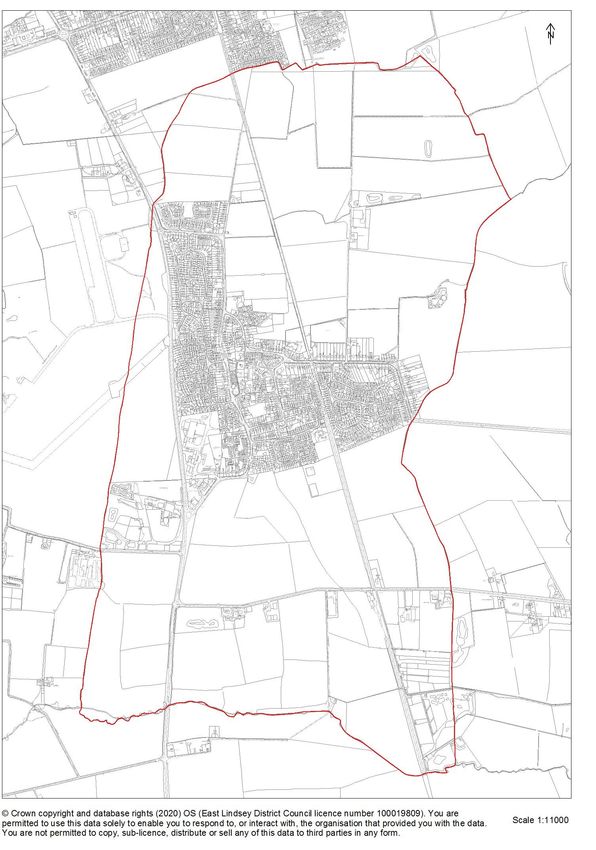
Vision, Objectives and Policies

                              Revision History

Revision     Date             Comments              Author       Approved
  0.1       24/4/16       Presented to ELDC
                            Planning Policy       HLC NDP          Yes
                                                   Team
  0.2       10/5/16       Updated with Anne      Bob Bolton
                               Shorlands’                          Yes
                               comments
  0.3        2/6/16      Final Update prior to   Barry Clifton     Yes
                             Health Check
  0.4       20/10/16       Update with Andy       HLC NDP          Yes
                         Booths Health check       Team
  0.5        4/1/17           Update with         HLC NDP          Yes
                             Andy Booth’s          Team
                               Comments
  0.6       15/5/17       Updated with Anne       HLC NDP          Yes
                               Shorlands’          Team
                               comments
  0.7      January and      Amendments to        Clive Keble
           March 2020      reflect Examiners
                                 report

                                      2
Holton-le-Clay Neighbourhood Development Plan - Index
Page
2 Revision history
3 Index
4-6 Introduction
4 Fig 1 Holton le Clay Designated Neighbourhood Plan Area (Parish Area)
7-8 Holton-le-Clay Neighbourhood Development Plan
1 Vision and 2 Objectives
9 3 Holton-le-Clay Neighbourhood Development Plan
10 -11 4 Overview of Holton-le-Clay
12 5 Developer Consultation
13 - 15 6 HLC Policy 1 Design and its impact on surroundings.
16 -17 7 HLC Policy 2 Building Style and Design of Properties
18 8 HLC Policy 3 Affordable Housing
19 - 23 9 HLC Policy 4 Implementation of Holton-le-Clay Green Plan
22 Fig 2 Holton le Clay Village Built Up area
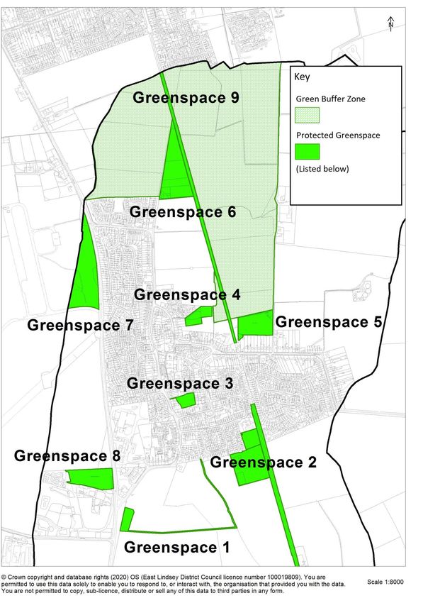
24 Fig 3 Holton-le-Clay Protected Green Spaces and Green Buffer Zone
25 - 29 Table 1 Holton-le-Clay - Existing Key Green Features
30 - 31 Table 2 Aspirational Key Green Features
31 Fig 4 Potential Cycle ways, New Footpaths and Safe Road Crossings
32 10 HLC Policy 5 Sustainable Urban Drainage
33 Fig 5 Holton-le-Clay Map Risk of Surface Water Flooding
34 Fig 6 Holton-le-Clay Risk of Flooding from Rivers
35 Fig 7 Holton-le-Clay Surface-Water Drainage Map
36 - 37 11 HLC Policy 6 Employment and Business
38 12 Implementation and Review
Appendices
1 Village Character Assessment (Available as a separate document).
2 Green Plan (Available as a separate document).
3 Identification of Key Views (attached).
4 Housing completions and commitments in/around Holton Le Clay (attached).
Other
Submission
Documents
Basic Conditions Statement (updated January 2020 – separate).
Consultation Statement (updated January 2020 Separate)
Scoping and Appraisal of Objective Statement (separate
SEA Screening Assessment (Determination Jan. 2020- separate).
3
Introduction to the Holton-le-Clay Neighbourhood Development Plan

Planning Context

In April 2012 the Localism Act 2011 amended the Town and Country Planning Act
1990 (the Act) introducing new rights and powers to allow local communities to
shape new development in their community by preparing a Neighbourhood
Development Plan, which can establish general planning policies for the
development and use of land in the neighbourhood. This document is a
Neighbourhood Development Plan as defined in the Act.

Holton-le-Clay Neighbourhood Development Plan has been prepared by a
dedicated team of volunteer villagers and endorsed by Holton-le-Clay Parish
Council, which is the qualifying body for the Neighbourhood Plan. The Plan applies
to the Parish of Holton le Clay in the East Lindsey District of Lincolnshire. In
accordance with Part 2 of the Regulations, East Lindsey District Council (ELDC),
the local planning authority, publicised the application from Holton le Clay Parish
Council to be a Neighbourhood Area and advertised a six-week consultation
period. The application was approved by ELDC on 8th January 2013 and Holton le
Clay Parish was designated as a Neighbourhood Area. Figure 1 (overleaf) is a
map of the designated Neighbourhood Plan Area. Holton le Clay Parish Council
confirms that this:
i.)    Neighbourhood Development Plan relates only to the Parish of Holton le
       Clay and to no other Neighbourhood Areas.
ii.)   Is the only Neighbourhood Development Plan in the designated area. No
       other Neighbourhood Development Plan exists nor is in development for
       part or all of the designated area.
iii.)  The Plan does not deal with excluded development.

In order to conform to the Localism Act the Holton le Clay Neighbourhood
Development Plan must:
a. Have appropriate regard to national planning policy;
b. Be in general conformity with strategic policies in the development plan for the
local area and contribute to sustainable development. The Parish of Holton le Clay
is part of the District of East Lindsey. The local strategic context is, therefore, set
by the emerging East Lindsey Development Plan.
c. Be compatible with European Union (EU) obligations & human rights
requirements.

The Holton-le-Clay Neighbourhood Development Plan was originally prepared to
run concurrently with the then emerging East Lindsey Local Plan and apply until
2029. However, the passage of time since submission in early 2018 means that
the East Lindsey Local Plan (The Core Strategy and The Site Allocations DPD)
which was adopted in July 2018, now provides the Strategic Planning framework
for the Holton le Clay Neighbourhood Development Plan, the plan period of which
has been extended from 2029 to 2031. This is the final version of the Holton le
Clay Neighbourhood Development Plan and it incorporates changes and updates to
meet the recommendations formally made by The Examiner following the
consideration of the Submission Version in 2018.

                                            4
Fig 1: Holton-le-Clay Designated Neighbourhood Plan Area (Parish Area)

                                   5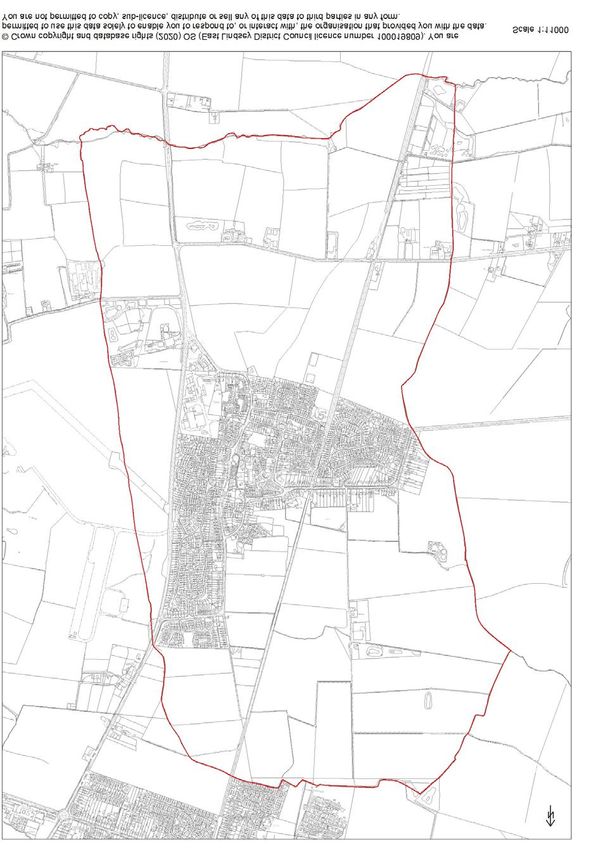
Other documents

   In accordance with the Regulation 15, a Basic Conditions Statement and a
   Consultation Statement were prepared at the Submission Stages. The Basic
   Conditions Statement has been updated to reflect the recommendations made by
   the Examiner, including; reference to the 2018 East Lindsey Local Plan, the
   revised NPPF (2019) and the need (or not) for a Strategic Environmental
   Assessment (SEA) to be carried out on the Neighbourhood Plan.

   The Consultation Statement has also been amended on the recommendation made
   of the Examiner. The list of people and organisations contacted as part of the
   Regulation 14 Consultation and the extent to which adjoining Parish Councils were
   involved has been considered. All Parishes were involved in written invitations and
   consultation meeting in 2016, but Humberston and Brigsley (in NE Lincolnshire)
   and North Thoresby, Granby & Waithe (East Lindsey) did not engage further and
   were not included in the Regulation 14 Consultation. However, both NE Lincs. and
   East Lindsey Councils were formally consulted. It is pertinent that Brigsley and
   Waithe have only short, rural boundaries with Holton le Clay and there is no direct
   impact on them that would arise from Neighbourhood Plan Policies. Again, in
   response to Examiner recommendations, additional notes and maps have been
   produced to explain how the key elements/policies of the Neighbourhood Plan,
   relating to open countryside and open spaces and views, are well grounded in the
   original research, evidence and policy context for the Neighbourhood Plan.

   Background

   It is, however, a response to the needs and aspirations of the local community as
   understood today and it is recognised that challenges and concerns are likely to
   change over the period of the plan. Holton-le-Clay Parish Council, as the qualifying
   body, will be responsible for maintaining and periodically revisiting the plan to
   ensure relevance and monitor delivery.

   The Holton-le-Clay Neighbourhood Development team has carried out extensive
   village surveys to gather residents’ views and consulted with a number of
   village Community Groups, to ensure a broad spectrum of views and opinions
   have been captured. The information gathered has been used to inform the
   creation of a Vision for the future sustainable development of Holton-le-Clay. The
   Neighbourhood Development Plan, underpinned by the Holton-le-Clay Village
   Character Assessment which should be read in conjunction with this document,
   provides detailed objectives and policies explaining how the vision can be
   achieved. The Holton-le-Clay Green Plan was produced to reflect the views of
   village residents and underpins the Holton-le-Clay Neighbourhood Development
   Plan. Throughout the process the team has liaised with the Local Planning
   authority and, prior to submission, the Plan was subjected to an independent
   health check. During the production process the team has shared the emerging
   plan with village residents and it has been revised to incorporate their feedback.

  We would like to thank all the Villagers who made valued contributions, with a
  special thanks to school children whose wonderful pictures, poems and ideas have
  helped us to create our community’s future vision for the village of Holton-le-Clay.

   The Holton-le-Clay Neighbourhood Plan has taken a positive approach to the
   development of housing, employment, retail, community and leisure development

                                             6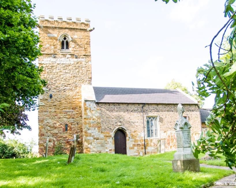
to ensure Holton-le-Clay remains a sustainable, attractive and vibrant place to
   live, providing all the amenities you would expect in a desirable semi-rural village.
   All development over the plan period will maximise the well-being and safety of
   residents and the environmental assets in and around Holton-le-Clay, maintaining
   and improving access to the countryside and open spaces for residents.

   The policies in this Neighbourhood Development Plan will be used by developers
   and Holton-le-Clay Parish Council in preparing and responding to planning
   applications and by the Local Planning Authority in assessing them.

Holton-le-Clay Neighbourhood Development Plan Overall Vision
                       and Objectives

1 Overall Vision By 2031, Holton Le Clay will be a village;

  1.1 Where new development addresses the aspirations of the community without
      impacting on the valued rural character of the village.
  1.2 Where there is an opportunity for residents to enjoy a good quality environment in
      a rural setting where (in accordance with the NPPF) new development does not
      significantly harm the character and appearance of the settlement.
  1.3 Where residents can enjoy a good quality of life that provides an opportunity for a
      variety of high-quality leisure and sports facilities for all ages.
  1.4 Where employment and economic growth are supported without impacting on the
      character of the village.
  1.5 Where new or improved infrastructure is provided to meet the needs generated by
      and mitigate the impact of new development (Paras. 34 and 57 NPPF)

2 Objectives
  2.1 To achieve our Vision of ensuring that any new development will address the
      aspirations of the community without impacting on the valued rural character of
      the village, the Neighbourhood Plan:
      2.1.1 Sets out design policy guidance for all new development.
      2.1.2 Identifies the views into and out of the village which should be protected.
      2.1.3 Identifies open spaces and recreational areas in the village which should be
             protected.
  2.2 To achieve our Vision of ensuring that there is an opportunity for residents to enjoy
      a good quality environment in a rural setting, the Neighbourhood Plan:
      2.2.1 Maintains the predominantly open and undeveloped rural character of the
      areas of open countryside between Holton-le-Clay and neighbouring settlements to
      avoid coalescence and retain a compact built-up area which does not sprawl.
      2.2.2 Protects the individual settlement of Holton-le-Clay and in particular, its
        semi-rural character by following the principles outlined in the Green Plan.

                                              7
The Bull field - An example of the important open countryside surrounding Holton Le Clay

2.3 To achieve our Vision of a parish where residents can enjoy a good quality of life
    that provides an opportunity for a variety of high-quality leisure and sports facilities
    for all ages, the Neighbourhood Plan:
    2.3.1 Protects and commit to improving the essential community facilities in our
            village in order to meet the needs of new development.
    2.3.2 Requires new development to meet any additional needs generated and
            avoid adverse impact on existing leisure and sports facilities, including parish
            gardens. (NPPF Paras. 56 and 96)
2.4 To achieve our Vision of a village where employment and economic growth are
    supported without impacting on its character, the Neighbourhood Plan:
    2.4.1 Protects the existing employment areas within the village.
    2.4.2 Seeks to encourage future employment opportunities and economic growth
            within the parish, ensuring they do not significantly harm the character
            appearance and setting of the settlement.
2.5 To achieve our Vision of a village where infrastructure is capable of delivering
    planned growth, the Neighbourhood Plan:
    2.5.1 Locates development to minimise traffic generation and provide good
            connectivity to key facilities, such as schools and the village centre.
    2.5.2 Commits to ensuring that new development, if and where possible,
            improves the road network around the village and does not impact on
            existing problems.
    2.5.3 Ensures that all new development meets the additional infrastructure needs
            that it will generate without adversely affecting existing provision.

                                             8
St Peter’s Church a community and heritage focal point for Holton Le Clay

Section 3 Holton-le-Clay Neighbourhood Development Plan

3.1   The Neighbourhood Development Plan (NDP) contains policies and proposals - the
      successful delivery of which, during the plan period, will achieve the Community’s
      Vision for the village of Holton-le-Clay.

3.2   The Plan will support the development of housing, employment, retail, community
      and leisure facilities which will ensure that Holton-le-Clay remains sustainable and an
      attractive, vibrant and desirable place to live.

3.3   All development over the plan period will maximise the well-being and safety of
      residents and the environmental assets in and around Holton-le-Clay, maintaining
      and improving access to the countryside and open spaces for residents.

3.4   The Neighbourhood Development Plan does not seek to set out proposed housing
      targets or allocate land for development. Decisions regarding these will be made in
      accordance with the ELDC Local Plan. It does however seek to preserve the semi-
      rural character of the village by influencing the design of developments.

3.5   The policies in this Neighbourhood Development Plan will be used by Holton-le-Clay
      Parish Council and Developers in preparing planning applications and by planning
      officers and the Local Planning Authority in assessing them.

3.6   In this way, these policies will guide future development in Holton-le-Clay and
      ensure that the wishes of the Community are taken into account, as envisaged by
      the Localism Act 2011.

                                               9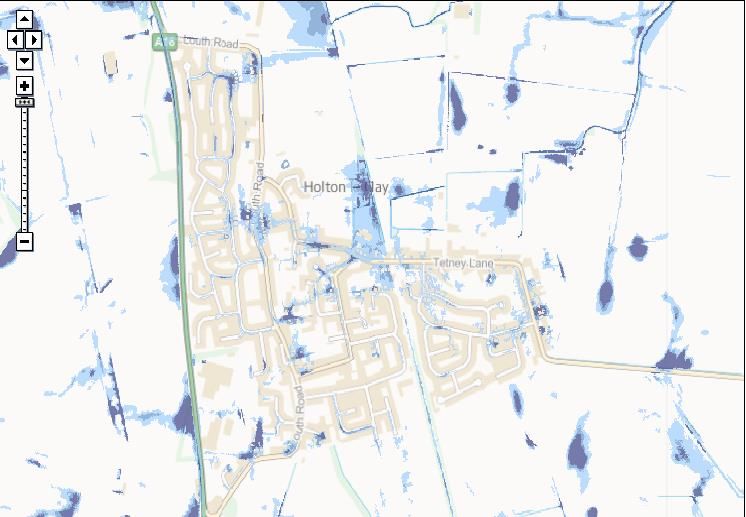
3.7   Each Neighbourhood Development Plan policy is numbered and includes:
       3.7.1 A Policy Vision
       3.7.2 An explanation and justification for the policy, including, where appropriate,
              reference to the relevant key evidence
       3.7.3 A Statement of policy

3.8   The application of criteria outlined in policies, will draw upon local detail set out in the
      Character Study and the Green Plan, in particular in relation to: important open land,
      key views and detailed design. The Character Study and how it can be used to help
      to achieve sustainable development is considered in the next section.

                                               10
Section 4: Overview: achieving sustainable development in Holton-Le-Clay
4.1 Sustainable Development is development that meets the needs for the present
without compromising the ability for the future generations to meet their own needs.
4.2 Holton-le-Clay is a semi-rural village surrounded by fields and natural spaces, which
has its own special character, local identity and sense of community pride, as
recorded in the Village Character Assessment (Appendix 1 of this document). The
village developed around the Parish Church of St. Peter and the original through
roads of Louth Road, Church Lane and Tetney Lane.
4.3 New developments have been built behind the properties on the main roads in such
a way that a person travelling through Holton-le-Clay might not be aware of them
and the village feels compact. These later developments were designed and built in
such a way that they continued the characteristics shown by the older part of the
village which are:
4.3.1 Roads with wide pavements and grass verges which generate a sense of
space and the appearance that the roads are wider than average.
4.3.2 Properties built in a variety of traditional styles and materials.
4.3.3 Most properties set back from the road in their own gardens – the role of
front gardens and people’s ability to personalise them is a key factor in
delivering the area’s character.
4.3.4 Most properties have off-road parking for two or more cars.
4.3.5 Open Spaces and mature trees.
4.3.6 Open views and outlooks and easy access to the public footpath network.
4.3.7 A strong sense of community and a low fear of crime.
4.3.8 Given these features, it is not surprising that in Village Character Surveys
residents of Holton-le-Clay are unequivocal in their desire to retain the
character of the village and protect its rural setting. They are of the opinion
that if a new development were to occur it should be made up of properties
of different sizes and styles. A preference could be seen for properties
having two or three bedrooms and for bungalows. A large number of
responses suggested that these should be affordable homes and that priority
should be given to young people from the village. A need for Specialist
Accommodation for Senior Citizens was also identified.
4.3.9 With average income in Lincolnshire approximately £24,000 (payscale.com
Jan 2020) and an average house price in the local area (DN36 Post Code) of
£221,166 (Zoopla Jan 2020), it is clear that there will be people who are
unable to buy a property on the open market.
4.4 The Neighbourhood Development Plan supports the development of affordable
housing for shared ownership and open market sale to local people. Residents have
consistently expressed a desire that affordable housing should meet the needs of
local people with strong local connections to Holton-le-Clay.
114.5 It is important to protect existing employment areas within the village to ensure that
local businesses remain and new investment in the village is encouraged. Local
business growth will increase the sustainability of Holton-le-Clay as a retail and
service hub for surrounding villages. The plan will offer opportunities for business
growth and employment opportunities within the parish, whilst ensuring they do not
impact on the rural character and setting of the area.
4.6 Developments should create a sense of place, making Holton-le-Clay a desirable
village to live in and where residents feel able to go about their daily routines
without the fear of crime. Crime prevention should be a material consideration in
the design of new developments. They should also promote community safety and
cohesion.
4.7 An important part of community safety is to ensure that any development provides
sufficient space for vehicles to park and manoeuvre: taking into consideration its
location, layout, size, shape, access requirements and purpose.
It is important to ensure that parked vehicles do not become either a safety hazard,
an environmental nuisance or dominate the street scene.
The Village Hall – a key facility Louth Rd - A typical, wide and leafy, street scene
12Section 5 Developer Consultation
5.1 The Parish Council would strongly encourage potential developers to discuss their
proposals at an early stage of the process. Local knowledge is considered very
important and feeding this into the planning process at an early stage would help
identify potential local issues and material considerations. This dialogue will help
develop their plans in accordance with the Vision outlined in The Neighbourhood
Development Plan.
5.2 In order to provide mitigation to the local community for any impact caused by
future development, for example if open space is lost in order to shape a new
development, Section 106 Contributions Agreements may be negotiated with the
Local Planning Authority.
5.3 Section 106 Agreements are subject to legal tests; these are:
5.3.1 Necessary to make the development acceptable in planning terms;
5.3.2 Directly related to the development;
5.3.3 Fairly and reasonably related in scale and kind to the development.
The objective is to mitigate the effects caused by a development at the same time as
enhancing the sustainability of the village, for example, the need for more school
places or additional facilities for the community such as improvements to the Holton-
le-Clay Village Hall. It can include building new roads or improving old ones which
already provide access to the development.
5.4 There is an expectation that Developers will liaise with the Parish Council, the
Highway Authorities and the appropriate bus operators to encourage better planning
of public transport. Measures relating to public transport, including bus passes for a
specified period, will be encouraged as well as physical infrastructure improvements
for public transport. Increasing the options for the use of public transport will help
reduce congestion on roads and increase accessibility for all sections of the local
population. Continual improvement is sought and where new housing and
employment is developed particular focus should be given to serving them with
public transport.
Louth Rd - Existing character, infrastructure and landscaping
13Section 6
HLC Policy 1 Design and its impact on surroundings.
Policy Vision
6.1 To be attractive and function well, the design of residential and commercial
development should take into account and pay particular attention to the positive
characteristics of Holton-le-Clay, including physical layout, the types of new buildings
proposed and levels of access, open space and car parking.
6.2 Residential and commercial developments should:
6.2.1 reflect the qualities of the best of the surrounding landscapes and townscapes,
as identified by the Holton-le-Clay Village Character Assessment;
6.2.2 provide spatial characteristics and building forms that are sympathetic to
the surroundings, including housing density, and property boundaries;
6.2.3 respond to existing land uses, providing an appropriate mix of dwellings/uses;
6.2.4 integrate with existing patterns of movement;
6.2.5 support the infrastructure associated with modern lifestyles and low
environmental impact, e.g. broadband and electric vehicle charging points.
Justification
6.3 The larger developments which have been allocated/committed in Holton le Clay,
together with any new sites that emerge in the future, having satisfied other policies
in this Neighbourhood Plan, could undermine the semi-rural characteristic of the
village and put undue pressure on existing infrastructure. National policy does not
provide any guidance on site-densities, but it is important to retain the historic
character of the village, including the setting of Listed Buildings. To ensure this,
development should be designed so as not to appear monolithic and if necessary
phased. This will allow needed infrastructure requirements to keep pace with
development and support more sustained growth of the village. The Policy is
intended to apply to; residential allocations in the ELDC Adopted Settlement Plan
e.g. Site HLC303 (15.4 ha/285 dwellings) on Louth Road (outline rather than
detailed consent), site HLC 302 and in future, to sites of 10 or more dwellings (or
over 0.5 ha), in accordance with the definition of major development in the NPPF.
6.4 Village surveys have shown that the residents value wide roads with sweeping
junctions, grass verges and wide pavements which are a fundamental characteristic
of the village. These are identified in the Holton-Le-Clay Green Plan and
development should reflect these characteristics. Slowing traffic down and keeping
vehicles and pedestrians separate to ensure residents are safe is a key priority for
the health and well-being of the community. All new developments should
incorporate safe road layouts (Department of Transport - Manual for Streets).
6.5 Inconsiderate parking has been identified by residents as a problem in the village
and therefore the Plan seeks to promote the design of new developments to provide
sufficient off-street convenient parking without dominating the street scene.
146.6 Infrastructure to connect to high speed broadband is an expectation for modern
lifestyles, in particular for residents who work from home. Some current residents
have reported intermittent broadband coverage in some parts of the village. Some
residents aspire to the provision of low cost clean energy and the facility to recycle
valuable commodities e.g. water and provide minimum environmental impact.
6.7 Public consultations have shown that feeling safe from crime is highly valued by
residents of Holton-le-Clay.
Policy HLC1 – Design and its impact on surroundings.
Development will be supported that provides the following measures (where they are
applicable to the proposal in question):
6.8 The design and layout reflects the existing village character as set out in the Holton
le Clay Village Character Assessment. This should include streets that provide
segregation between vehicles and pedestrians. If possible streets should have grass
verges to at least one side in order to preserve the sense of space which is a
characteristic of Holton-le-Clay. Road layout should facilitate traffic calming and cul-
de-sacs, as recommended in ‘Secured by Design’.
6.9 The design should demonstrate through the application process how it will contribute
to crime prevention, promote community safety and promote the use of public
spaces by complying with the police initiative ‘Secured by Design’. Buildings should
face towards streets, paths and open spaces, to encourage natural surveillance.
6.10 The design of a new development should demonstrate how it will facilitate the
provision of high speed broadband and sustainability factors such as green energy
and charging points for electric cars.
6.11 Sufficient parking and manoeuvring space must be provided, commensurate with
the size of each property. Parking should preferably be within the curtilage of each
dwelling. Use of off property parking should be fully justified and the design should
ensure that parking spaces are provided as close as possible to the residence and
are overlooked by the occupants of the properties. Parking bays should be designed
so that they do not dominate the street scene.
6.12 Larger scale new residential developments (10 or more dwellings or over 0.5ha)
must be designed to include usable private green space (e.g. front and rear
gardens) and shared accessible greenspaces. These may include the planting of
trees and hedges to reduce the impact of parked vehicles and waste storage or
recycling containers and preserve the semi-rural character of the area in accordance
with the Holton-le-Clay Green Plan.
6.13 All new development must be designed so that it preserves and does not obstruct
important and public views and wherever possible enhance landscape and bio-
diversity. The Key Views are assessed listed and mapped in Appendix 4 (attached).
6.14 To strengthen the character of the village, developments should be designed to
have constantly changing patterns of interesting spaces, enclosures and open space
to create visual amenity and a sense of place in accordance with best practice.
6.15 Active Travel and sustainable transport features should be provided, including:
- pedestrian and cycle connections to the village centre and other local destinations.
15- safe and direct access to public transport and deliver this within the development.
- avoiding or mitigating any adverse impact on road users or pedestrians.
- allowing for the safe access, manoeuvring and exiting of service vehicles (e.g.
Refuse Collection) whilst maintaining safe vehicle and pedestrian segregation.
6.16 A plan for lifetime maintenance of the highways and public green spaces on
proposed developments should be presented as part of the planning process so that
suitable management regimes may be secured.
6.18 It should be noted that the application of the above Policy must not supersede or
replace the considerations that apply to Listed Buildings contained in national
policy/legislation and policies in the East Lindsey Local Plan.
6.19 Major development should consider providing a recycling area for use by the wider
community.
Edinburgh Drive Langton Rd
Established housing areas showing the value of gardens, incidental open space and trees
167 HLC Policy 2 - Building Style and Design of Properties
Policy Vision
7.1 The style, design and layout of new residential properties in Holton-le-Clay should be
based on and build on the positive aspects of the character and appearance of the
surrounding area and provide accommodation to meet the needs of current and
future residents of the village. The building styles and vernacular, as identified by
the Holton-le-Clay Village Character Assessment, should be reflected.
Justification
7.2 In the Village Survey residents were of the opinion that where new development
occurs, it should be made up of properties of different sizes and styles, including
bungalows. Properties are mainly constructed of brick and tile, single or two storeys
with a variety of plot sizes and this gives the village its unique character which it is
important to preserve. The role of functional and usable gardens and the way
residents personalise them both front and rear is a key factor in creating the semi-
rural character of the village.
7.3 The protection of privacy for occupants of the properties and neighbours in the
village is very important; development should seek to ensure that this is provided.
7.4 The street scene can become cluttered with refuse and recycling bins and this can
affect both the visual and residential amenities of properties, the Plan seeks to
mitigate against this and to limit the nuisance caused by noise and smells.
7.5 The 2011 census showed that the 16-34 age group represents 17% of the population,
the 35-54 age group represents 28% of the population and the over 55s represent
36% of the population. At the public consultation some younger members of the
community remarked that there were few houses in the village that they could
afford, and some older residents said that they would like to ‘downsize’ if suitable
properties became available in the village.
Tetney Lane & South View - Further examples of the importance of trees and landscaping
17Policy HLC 2 – Residential Building Style and Design
Residential development schemes will be supported where the design approach
addresses/considers elements identified in the Character Study and Green Plan and fulfils
following criteria.
7.5 Provides a mix of plot sizes and bedrooms, to reflect the variety of needs at
the time of application with, starter and family homes and retirement units.
7.6 Incorporates properties with a range of styles, types, height and density including
single storey housing for older people or those with limited mobility.
7.7 The design of a development should protect the privacy of habitable rooms in each
dwelling. Development should not dominate neighbouring properties by reason of
height, mass or overshadowing.
7.8 The design of new developments must provide for discrete on-property refuse
storage and recycling areas.
7.9 The design of discrete refuse storage and recycling areas for terraced or link
properties should aim to conceal them or mask their impact on the street scene. In
flat and apartment buildings, refuse storage space may be provided communally,
enclosed in a carefully designed building integrated within the overall development.
Church Lane - The transition between the older and new parts of the village
188 Policy HLC 3 Affordable Housing
Policy Vision
8.1 The policy is designed to reflect the need to enable growth to occur in Holton-le-Clay
by meeting local housing needs, based on the latest Local Housing Market
Assessment and Local Housing Needs data. All new housing proposals for 15 or more
dwellings should deliver a housing mix including affordable housing that reflects the
current needs of Holton-le-Clay. The East Lindsey housing register will be used to
inform the level and type of need for affordable homes for local people in the village.
The percentage of affordable housing is set out in the East Lindsey Local Plan.
Strategic Policy 7 (SP7) which requires sites of 15 or more houses to see a 30%
developer contribution towards the provision of affordable housing.
Justification
8.2 Affordable housing has the meaning given to it in Annexe 2 of the NPPF (2019),
“housing for sale or rent for those whose needs are not met by the market, including
housing that provides a subsidised route to home ownership and/or is for essential
local workers…” Given the size of the population of Holton-le-Clay it is inevitable that
there will be residents who cannot access open market housing: these could be
young people living with parents or people living in low quality overcrowded housing.
Policy HLC3 – Affordable Housing
8.3 Developers need to demonstrate how a particular residential development
proposal will meet the local need for affordable housing, including reference to
the East Lindsey Housing Register and local surveys where appropriate.
8.4 In accordance with Policy SP7 of the Local Plan, the first choice is that affordable
homes should be provided on site and must be fully integrated with the market
housing throughout the whole development and must be visually
indistinguishable from market housing. Where affordable housing cannot be
provided on site, the alternatives listed in the policy SP7 must be applied.
8.5 Affordable housing should be allocated according to the principles set out in the
Local Plan, focussing in the first instance on local people.
199 HLC Policy 4 - Implementation of Holton Le Clay Green Plan
Policy Vision
9.1 With a population under 10,000, using the Government’s rural/urban classification
2011, Holton-le-Clay is classified as rural. Semi-rural would be a more accurate
description: “a location that is of country but that is not officially considered country.
For example, an out of town suburb near farm country” (www.yourdictionary.com).
Holton-le-Clay has been a settlement in its own right for many years and so would
be accurately defined as a semi-rural village. The Village Character Assessment
(Appendix 1) describes the form of the settlement and the village surveys
demonstrated that village residents want to retain this characteristic, by:
To the North, to safeguard against coalescence with North-East Lincolnshire.
Recognising a clearly defined village edge.
Using the Green Plan as a positive tool for safeguarding Village Character whilst
facilitating levels of sustainable growth.
9.2 Open countryside, comprising farmland, rural land uses and open spaces is an
essential part of the overall semi-rural character of Holton-le-Clay. This contributes
significantly to a positive living environment and help to bed new developments into
the location and the wider village. In addition, open spaces can be part of green
infrastructure, benefitting the wider community. Green Infrastructure covers a
variety of types of spaces including woods, parks and gardens, green lanes, public
rights of way, church yards, sports facilities and water-courses. Green infrastructure
provides habitats for wildlife; opportunities to adapt to climate change; and, on
larger sites, recreational opportunities and the promotion of the health and well-
being of residents. This is supported by Strategic Policy 25 in the ELDC Local Plan.
9.3 A key part of the Neighbourhood Plan is the creation of a Holton-Le-Clay Green Plan
(Appendix 2), which will enhance the green infrastructure of the village, making it a
desirable place to live, work and visit. The Green Plan will connect the community
with their local green environment and provide opportunities for leisure, sport and
education. This is supported by Strategic Policy 26 in the ELDC Local Plan.
9.4 The Green Plan will enhance biodiversity, heritage and landscape whilst promoting
sustainable non-vehicular access to and around the village. Accessible and Natural
greenspaces such as informal open spaces, parish gardens, playing fields, footpaths
and cycleway networks, children’s play areas, woodland and land of bio-diverse
value are key features of the Holton-Le-Clay Green Plan. New developments in the
village will be expected to conform to the principles of the Holton-le-Clay Green Plan.
9.5 The Green Plan is intended to ensure that Holton-le-Clay will continue to be a semi-
rural village which benefits from its connection to the local countryside. The
identification of the extent of the existing/committed built up area is important. Fig 2
shows the built-up area, beyond which open countryside policies apply. This is
regarded as an important practical application in retaining the Village Character. It
also maintains the village identity which promotes social cohesiveness and sense of
community. These features underline the feeling of safety described by residents in
20Village Surveys. The definition of the built-up area and carefully managing the extent
of new development beyond it, is essential to avoid coalescence with nearby
settlements. The identified built-up area is based on the principles that:
- Countryside extending into the village is an important part of its character
- Large farm buildings on the edge relate to the countryside, not the village.
- It represents the developed footprint or continuous built form of the village,
excluding dispersed dwellings and other structures along linear routes.
(Note. It is not intended that Fig. 2 constitutes a settlement boundary, which could
give rise to a policy conflict with the Local Plan and is not established practice in East
Lindsey. However, it is felt that the map is a useful informal reference point for the
implementation of the Neighbourhood Plan). Furthermore, the approach is felt to be
consistent with Strategic Policy 3 (housing growth and the location of inland
development) in the 2018 Local Plan and in particular, Para. 4 which defines the
“developed footprint” in Towns and large villages, including Holton Le Clay
9.6 Within the open countryside area, Fig. 3 shows especially important areas of open
land, linked to public footpaths, open spaces and key views (See Appendix 4). These
need to remain open to protect Holton-le-Clay from coalescence with neighbouring
settlements in North East Lincolnshire. The identification of the built-up area has
been informed by reference to the amount and extent of recently built/committed
new housing in Holton le Clay and the nearby settlements of Waltham and New
Waltham. This totals over 2000 dwellings and details are given in Appendix 5.
9.7 Proposals for new development that lie within the location of the Green Plan will be
required to align their public open space designs with its objectives, so that they
contribute to its successful formation and maintenance. The Green Plan can define
the landscape of the village for future generations and its completion may extend
beyond the plan period. It will depend upon good communication and co-operation
between the Parish Council, ELDC, potential developers and landowners. Fig 4
illustrates the current and proposed footpaths and cycle ways in the Green Plan.
Church Walk - An important existing green corridor/footpath
21Justification
9.8 Consultation showed that residents value village characteristics such as, open
aspects and outlooks, green spaces and mature trees, houses with front gardens,
green verges to roads and easy access to a network of public footpaths. These
features are considered integral to Holton-le-Clay’s definition as a semi-rural village.
The northern boundary of the parish adjoins the parishes of New Waltham, Waltham
and Humberston in NE Lincolnshire and at present there is green countryside
separating the village from these. The Green Plan seeks to maintain the
undeveloped rural gap between settlements and avoid coalescence. Villagers regard
it as important that green areas between the settlements is protected and existing
mature green landscape features are enhanced and maintained.
9.10 Access to high quality open spaces and opportunities for sport and recreation can
make an important contribution to the health and well-being of the community. The
Accessible Natural Green Space Standards, developed by Natural England, require
that every home should be within:
9.10.1 300 m of an accessible natural green space of at least 2 ha, plus:
9.10.2 At least one accessible 20 ha site within 2 km
9.10.3 At least one accessible 100 ha site within 5 km
9.10.4 At least one accessible 500 ha site within 10 km 18.5
9.11 For the purposes of Accessible Natural Green Space Standards natural green space is
considered to be, ‘places where human control and activities are not intensive so
that a feeling of naturalness is allowed to predominate’.
9.12 It is vital that this Neighbourhood Plan maximises the opportunity provided by new
development to improve and extend the provision of open green space where
possible (e.g. accessible public green space within developments – see policy 6.13).
It may not always be possible to meet this requirement, but the consultation showed
that all opportunities to extend and improve access to wildlife and green space are
important to residents. In the Village Survey the protection of green spaces
produced the highest score, with 55% of respondents thinking it was greatly needed.
9.13 The village is served by an existing 8 acre sports field, a junior recreational
facility/children’s play area, the long established cricket/football club, Parish
gardens, and several public footpaths and cycle ways. Table 1 contains photos and
locations of Holton-le-Clay existing Key Green Features. It is believed that these
facilities are insufficient for the village.
The existing cricket ground off Tetney Lane
22Figure 2. Holton Le Clay Built Up Area
Open Countryside
Open Countryside
Built Up Area
Open
Countryside
Open Countryside
Holton Le Clay Built Up Area
23Policy HLC4 – Implementing the Holton-le-Clay Green Plan
9.14 The generally open and undeveloped nature of the open countryside, identified on
Fig. 2, will be protected from inappropriate development to preserve the visual qualities
of the landscape, prevent coalescence and retain the separate identity of Holton Le Clay.
Open Countryside and Key Views
9.15 Development will be supported if the following requirements can be met:
(i) it would not undermine the physical and/or visual separation of Holton le Clay for
other nearby settlements, in particular the Green Buffer Zone identified on Fig. 3: and
(ii) the key views identified and described in Appendix 3 will be protected.
Important Open Spaces/Existing Green Infrastructure
9.16 Development should not compromise the integrity of identified important open
spaces or Greenspaces, either individually or in combination with other existing or
proposed development. Reflecting the Local Plan (Core Strategy and Site Allocations
DPD) the Greenspaces covered by this policy, as shown on Fig. 3 are:
1 (Planted Woodland), 2 (8 Acre Field), 3 (Junior Playing Field), 4 (Gardens/Cemetery),
5* (Cricket Club), 6 (Clay Lane Paddocks), 7 (100 Squadron Memorial & setting),
8 (Golf Club & Driving Range) and 9 (Former Railway Line).
The current purpose of the identified green spaces should be maintained and, where
possible, enhanced.
(*It is acknowledged that the Cricket Club may relocate to the north part of the approved
housing site East of Louth Road (N/085/00833/15 Outline), as part of open space and
recreation provision. However, in accordance with Para. 4 of the 2018 Local Plan Policy
SP3, which excludes “outdoor sports/recreation facilities and other formal open spaces on
the edge of the settlements” from the definition of the “developed footprint” the existing
site should remain open).
New Green Infrastructure Provision
9.17 Development proposal will be supported where the above criteria are met and:
- It will add to the provision of the Green Infrastructure in accordance with Green Plan
(Appendix 2), including the enhancement of biodiversity, sustainability and landscape.
New planning proposals should demonstrate how they will meet these expectations.
- It identifies locations and specifications for new accessible (communal) open space and
sports recreational provision to meet the needs generated by that development.
- It demonstrates how existing mature trees and natural green boundaries will be
maintained and enhanced and how the edge of new developments will be softened by
the planting of tree belts and hedges.
- It retains and where possible, extends and enhances existing public rights of way.
Designs should encourage the enhancement of connectivity and attractiveness for
walking and non-vehicular transport in and around the village, in line with Fig. 4
Potential Cycle Ways, New Footpaths and Safe Road Crossings and Table 2 Aspirational
Key Green Features. The needs of people with limited mobility should be accommodated
in designs to enhance the existing and new green infrastructure.
Associated Local Plan (2018) Policies.
9.18 This Neighbourhood Plan Policy will be applied alongside Policies SP25 (Green
Infrastructure) and SP 26 (Open Space Sport and Recreation) in the adopted Local plan
(Core Strategy) and for development to be deemed acceptable, the relevant criteria in
both policies will need to be satisfied.
24Fig 3: Holton-le-Clay Protected Green Spaces and Green Buffer Zone
Key
Green Buffer Zone
Protected Green
Spaces
Recent
Development
(Listed Below)
25Greenspace 1 - Planted Woodland
Greenspace 2 - 8 Acre Field
Greenspace 3 - Junior Playing Field
Greenspace 4 - Parish Gardens and Cemetery
Greenspace 5 - Cricket Club
Greenspace 6 - Clay Lane Paddocks
Greenspace 7 - Squadron 100 Memorial and setting
Greenspace 8 - Golf Club & Driving Range
Greenspace 9 - Former Railway Line
Table 1: Holton-le-Clay - Existing Key Green Features (From the Green Plan)
(Site 1 to 9 refer to fig 3, others are features covered by other policies and the Green Plan)
Feature – Description Location Why a Key
Feature
Extends from the Woodlands are
southern entry to the important in
village, running east creating links
for 0.5km parallel between scattered
with Station Road, areas of habitat.
before turning north Connectivity is
for approx. 0.5 km to important to allow
the southern the movement of
settlement boundary. plant and animals
Public footpath Woodland gives
passes though the people opportunity
woodland to interact with
wildlife in a natural
1 Planted Woodland Public Footpath to Planted
setting.
Woodland from the southern entry to the village.
Adjoining the village Recreational
junior School Playing facilities,
Field. health and well-
being of villagers.
Linked to public
and permissive
footpaths
The site has
significant
potential to be up-
2 Eight Acre Playing Field Large open playing field graded in terms of
surrounded by hedgerows and farmland. Football bio-diversity and
pitches, a BMX track and tennis courts (in disrepair) landscape features
make up the recreational facilities. The field is used as well as sports
frequently by dog-walkers and links with public provision
footpaths and proposed cycle ways in the Green Plan.
26Situated close to Activities play-park
village centre. equipped for
children up to
fourteen years of
age.
This site is ideally
located to serve
the community but
is not easily linked
to proposed Green
Plan routes other
than via normal
village footpaths.
3 Junior Playing Field A medium sized playing field
surrounded by housing close to the village centre with
access from Louth Road and Pinfold Lane. The field
has some basic playing facilities including climbing
frames and swings.
Situated off Church Parish Amenity -
Lane Community
growing space
providing the
opportunity to
grow health foods
4 Parish Gardens and Cemetery The Parish
Gardens (Allotments) and Cemetery provide both a
recreational service and natural habitat for wildlife.
Situated to the north Provides sports,
of Tetney Lane social and
recreational
facilities for the
village.
5 Cricket Club The Cricket Club is a privately run
enterprise providing social and recreational services to
the village including Fireworks displays and Music
Festivals as well as the more obvious Cricket related
activities. The site links well with public footpaths and
the disused railway line and it is considered to be an
important Green Infrastructure feature of this plan.
27Situated at the north This pocket of land
end of the village on is used as an
Clay Lane. equestrian centre.
This triangle of
land forms a
bookend for the
development at
the north end of
the village
6 Clay Lane Paddocks The paddocks at the end of
Clay Lane provide equestrian facilities as well as open
green views to be enjoyed by walkers along Clay Lane
or the disused railway line.
Northern entrance to 100 Squadron War
Holton-Le-Clay from Memorial.
the A16 Tourist Attraction.
Open Green Space
that announces
the Northern
entrance to the
village.
The adjoining
open land on the
7 War Memorial The War Memorial site mark the former airfield (up
Northern entrance to Holton-Le-Clay from the A16. to the Parish
The site is a popular destination for dog-walkers and boundary) is
people looking to walk across the airfield to the west. important to the
There is a small relatively young copse along with setting of the
hedgerows, benches and the war memorial itself. memorial.
Holton-le-Clay Golf Sports and
& Driving Range Recreational
Situated on the facility
Airfield
8 Holton-le-Clay Golf Club & Driving Range
28Old Railway Line Connecting
North/ South through footpath from
the village. From Holton-le-Clay to
Waithe on the New Waltham and
southern village forms part of a
boundary to New village circular
Waltham on the footpath. Which
Northern Boundary. connects to the
ancient “Meet and
Greet” footpath
from St Peter’s
Church Holton-le-
Clay to St Peter’s
9 Railway Line The disused railway lines runs N to S Church,
through the village. In addition to providing a green Humberston.
corridor has the potential to provide the spine for the
development of footpath network. The Parish Council
own a section on the East side of the 8 Acre Field and
has access rights on the section running S from the 8-
acre field to Station Road. The N section from Tetney
Lane to the New Waltham is a permissive footpath.
Holton-le-Clay Junior Education/Health/
School Playing Field Sports facility.
Picksley Crescent Open green village
space
Holton-le-Clay Junior School Playing Field
Holton-le-Clay Education/Health/
Infants School Sports facility.
Church Lane Open green village
space
Holton-le-Clay Infants School Playing Field
Located at the rear of 2 Ponds with
Holton-le-Clay marginal water
Infants School plants, frogs and
Church Lane newts.
Wildlife Ponds
29Across the road from Public footpath
St Peter’s Church to across wildflower
Railway. meadow.
Public footpath from Church to Railway
From Old Railway line Large, thick
to Louth Road wildlife hedgerow.
Large Hedgerow
From Clay Lane Wide ditch and
corner to Railway. mature trees
which contains
wildlife, fauna and
flora.
Mature Trees and Wide Ditch
From Clay Lane Wide hedge which
corner to Church contains which
Lane. contains wildlife,
fauna and flora.
Mature Hedgerow
30Table 2: Aspirational Green Features (including associated road safety measures)
Feature – Description Location Why a Key Feature
1Safe Crossing of A16 South entry/exit to village From village to Cheapside to connect to
(To enable better/safer from A16 to Cheapside wider cycle routes and public footpaths.
connection between the A16 is a 60mph road at this junction and
village and countryside, the Y junction is complicated and
link existing routes and hazardous. This creates a significant
improve green safety issue for pedestrians and cyclists
connectivity) crossing the A16; particularly for cyclists
turning right across the traffic flow.
2 Safe Crossing of A16 South entry/exit to village Safe cycle/pedestrian entry/exit to the
(As 1 above) at “Y” junction. To connect village. A16 is a 60mph road creating
to Cheapside and wider safety issues for cycle and pedestrians
cycle routes/footpaths. crossing or turning across the traffic flow.
3 Safe Crossing of A16 Existing public footpath Provide a safe cycle/pedestrian road
(As 1 above) from village which crosses crossing of A16 where public footpath
A16 to the former airfield crosses a 60mph. To allow safe access to
the open space on the former airfield.
4 Safe Crossing of A16 Existing public footpath Crossing of A16 where public village
(As 1 above) from village which crosses footpath crosses a straight 60mph section.
A16 and connects to public Allow safe access to the existing footpath
footpath to Waltham cycle way across the former airfield.
5 Potential New Green Existing public footpath Upgrade public footpath to combine
Infrastructures/Features from end of Louth Road in pedestrian footpath and cycleway.
the village to Station Road
6 Disused Railway Line Old railway line from Create public recreational access, footpath
southern end of village to and cycleway along old railway line from
Station Road village to Station Road.
7 Public Footpath Public footpath E/W along Extend east west footpath to formalise
boundary from Tetney unofficial much used footpath. To connect
Lane to join existing public east side and west side of the village by a
footpath at Louth Road green combined footpath and cycleway.
8 Footpath on access to Access from Tetney Lane Create a formal footpath along access
AWA Pumping Station to AWA Pumping Station road which connects to existing public
footpath from Humberston to Tetney.
9 Upgrade existing Public Existing public footpath Upgrade existing public footpath to a
Footpath from St Peters Church combined footpath and cycleway
Holton-le-Clay to St Peter’s
Church, Humberston.
10 Disused Railway Line Old railway line north from Create public footpath and cycleway along
Tetney Lane (Holton) to old railway line. Form an interconnection
Station Road New Waltham with existing public footways cycle ways
11 Footpath on old Airfield Disused Airfield Holton le Upgrade footpath to create a connecting
Clay footpath and cycleway to Waltham.
12 Proposed extension of Inghams Lane, Tetney Create a cycleway on Permissive Path
exist Bridleway from Tetney Lane Farmhouse to meet
ancient footpath between St Peter’s
Church and Humberston Church.
13 Proposed Cycle Lane Holton Road Holton-le-Clay Create Cycle Lane on Holton Road to
to Tetney create an cycle link to Tetney
14 Proposed connecting Footpath and cycleway Create an interconnecting footpath from
footpath and cycleway. from centre of village to Tetney Lane, through new Louth Road
Clay Lane Development, to Clay Lane
15 Proposed new footpath Louth Road to Disused Create an interconnecting footpath and
and cycleway. Railway Line cycleway alongside east – west drainage
from Louth Road to disused Railway Line.
16 Louth Road Louth Road running north Create Cycle Lane alongside main road
– south through village. from Clay Lane to Station Road
31Fig 4: Holton-le-Clay. Potential cycleways, new footpaths & safe road crossings
10 – Disused
Railway line,
Northern Section
9 – Meet and greet
footpath from St Peters
11 – Public Church Holton le Clay to St
Footpath 15- New Footpath Peters Church Humberston
14 – New
development
interconnecting
footpath
4 – A16
8 – Access Road
safe road
to AW pumping
crossing
station
12 – Bridleway
and Permissive
16 – Proposed footpath
new cycle route
long Louth Road
3 – A16
safe road 13 – Proposed cycle path
crossing
7 – Public Footpath
to Tetney
7 – Public Footpath
2 – A16
safe road 6 – Disused
crossing Railway line,
Southern Section
5 – Public
1 – A16
Footpath
safe road
crossing
3210 HLC Policy 5 - Sustainable Urban Drainage
Policy Vision
10.1 The Plan seeks to safeguard against and reduce where possible incidents of surface-
water flooding and supports sustainable urban drainage as a mechanism toward this
objective.
Justification
10.2 Some areas of Holton-le-Clay are vulnerable to Surface Water Flooding (Fig. 5) and
the wider area to River Water Flooding (Fig. 6). Alleviating flood-risk is a high
priority for residents. Future growth and development of Holton-le-Clay must not
increase the risk of flooding and betterment of flooding risk should be considered in
all future development designs. It is important that the drainage solutions proposed
as part of new development are sustainable and do not prejudice the important roles
of the maintained watercourses and main rivers, (see Fig. 7).
10.3 Proposals for sustainable urban drainage are to be strongly supported in new
developments and considered as part of the overall proposals for drainage. New
development will be expected to incorporate sustainable drainage schemes (SUDS)
wherever possible, taking into consideration potential land contamination or
groundwater sensitivities. It should be demonstrated that opportunities to use SUDS
as a way to provide quality green space and create additional habitat for wildlife
have been maximised.
10.4 A plan for lifetime maintenance of SUDS should be presented as part of the planning
process so that suitable management regimes may be secured. Anglian Water
supports the requirement to use SUDS and that the use of SUDS should be
maximised on site so as not to increase flood risk and to reduce flood risk where
possible.
Policies for Sustainable Urban Drainage
10.5 New development must be designed to prevent increased discharge of surface
water to the village’s drainage system - Fig 7.
10.6 Developments should demonstrate how they address the flood risk.
10.7 Development must demonstrate that capacity is available within the foul sewerage
network or that capacity can be provided in time to serve the development.
Necessary improvement of the system must be addressed through the phasing of
development.
Fig 5: Holton-le-Clay Map Risk of Surface Water Flooding
10.8 SUDS will be supported on developments and potential developers should
demonstrate what sustainable, robust and realistic maintenance arrangements will
be in place and how they contribute to green infrastructure and provide habitats for
wildlife.
33You can also read