CROSS GUNS BRIDGE STRATEGIC HOUSING DEVELOPMENT PHIBSBOROUGH DUBLIN - January 2021 - Cross Guns SHD
←
→
Page content transcription
If your browser does not render page correctly, please read the page content below
CROSS GUNS BRIDGE
STRATEGIC HOUSING DEVELOPMENT
                 PHIBSBOROUGH
                        DUBLIN

                        1
                  January 2021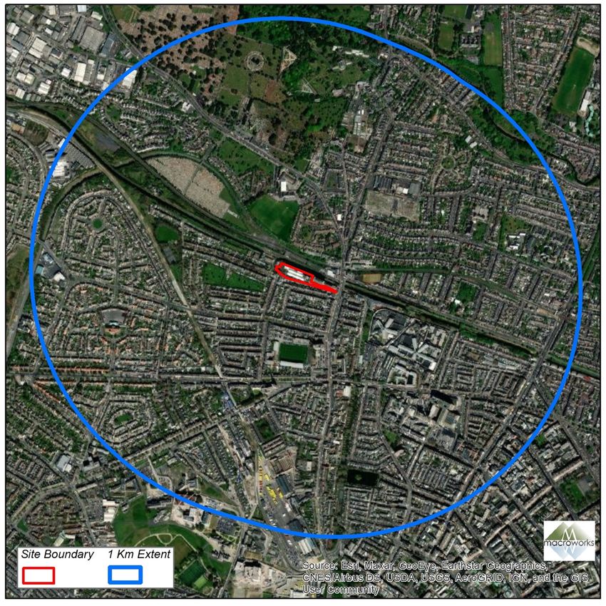
LANDSCAPE/TOWNSCAPE & VISUAL IMPACT ASSESSMENT

1.0   INTRODUCTION
This Townscape and Visual impact Assessment report has been prepared in respect of a Strategic
Housing Development by Bindford Ltd. at Cross Guns Bridge, Phibsborough, Dublin 7. This report
describes the townscape/visual context of the proposed development and assesses the likely
impacts of the scheme on the receiving environment, in terms of both townscape character and
visual amenity.
Landscape/townscape assessment relates to changes in the physical environment, brought about by a
proposed development, which may alter its character. This requires a detailed analysis of the individual
elements and characteristics of a landscape/townscape that go together to make up the overall
character of that area. By understanding the aspects that contribute to this character it is possible to
make judgements in relation to its quality (integrity) and to identify key sensitivities. This, in turn,
provides a measure of the ability of the landscape/townscape in question to accommodate the type
and scale of change associated with the proposed development, without causing unacceptable adverse
changes to its character.
Visual Impact Assessment relates to changes in the composition of views as a result of changes to the
landscape/townscape, how these are perceived and the effects on visual amenity. Such impacts are
population-based, rather than resource-based, as in the case of landscape impacts.

1.1   STATEMENT OF AUTHORITY
This Landscape/Townscape and Visual Assessment report was prepared by Macro Works Ltd of
Cherrywood Business Park, Loughlinstown, Dublin 18; a consultancy firm specialising in Landscape
and Visual Assessment and associated maps and graphics. Relevant experience includes a vast range
of infrastructural, industrial and commercial projects since 1999, including numerous mixed-used
development projects.

1.2   DESCRIPTION OF THE PROPOSED DEVELOPMENT
The proposal is for a Strategic Housing Development for Build-To-Rent apartments and will comprise
of the demolition of all derelict buildings on site and the construction of a new residential
development comprising of 3 no. blocks, ranging in height up to 12 storeys, consisting of 205 no.
dwellings and associated residential amenities, basement and surface carparking with vehicular and
pedestrian access from the eastern end of the site off Phibsborough Road.

There will be additional pedestrian-only accesses to the north of the site, off the Royal Canal Way. A
new café/retail area will be located at the ground floor level of Block C, along with a new public open
space to the east of the site. All associated site development works, landscaping and boundary
treatment, children’s play area, cycle parking, bin stores, substation, and services provision. A full
description is set out in the statutory notices.

                                                                                                      2
1.3       METHODOLOGY
Production of this Landscape/townscape and Visual Impact Assessment involved:

      •   A desktop study to establish an appropriate study area and relevant landscape and visual
          designations in the Dublin City County Development Plan 2016-2022;
      •   Fieldwork to study the receiving environment;
      •   Assessment of the significance of the landscape impact of the proposed development as a
          function of landscape sensitivity weighed against the magnitude of the landscape impact;
      •   Assessment of the significance of the visual impact of the proposed development as a
          function of visual receptor sensitivity weighed against the magnitude of the visual impact.
This document uses methodology as prescribed in the Institute of Environmental Management and
Assessment (IEMA) and landscape Institute (UK) ‘Guidelines for Landscape and Visual Impact
Assessment’ (GLVIA-2013).

Although this is principally a ‘townscape’ assessment, it utilises the same outline methodology as
would be employed for the more familiar Landscape and Visual Impact Assessment (LVIA) of
developments in rural settings. The justification for this approach is provided below.

It is important to note that the Guidelines for Landscape and Visual Impact Assessment’ (GLVIA-2013)
follow the European Landscape Convention (ELC) definition of landscape: ‘Landscape is an area, as
perceived by people, whose character is the result of the action and interaction of natural and/or
human factors’ (Council of Europe, 2000). Thus, GLVIA-2013 covers all landscapes from “high
mountains and wild countryside to urban and fringe farmland (rural landscapes), marine and coastal
landscapes (seascapes) and the landscapes of villages towns and cities (townscapes)” - whether
protected or degraded.
In the case of this project, the study area is overwhelmingly that of an urban setting or ‘townscape’
and this is defined in GLVIA-2013 in the following manner (Section 2.7):
“ ‘Townscape’ refers to areas where the built environment is dominant. Villages, towns and cities often
make important contributions as elements in wider-open landscapes but townscape means the
landscape within the built-up area, including the buildings, the relationships between them, the
different types of urban spaces, including green spaces, and the relationship between buildings and
open spaces. There are important relationships with historic dimensions of landscape and townscape,
since evidence of the way the villages, towns and cities change and develop over time contributes to
their current form and character.”

In this instance there is a strong interrelationship between the ‘townscape’ and ‘cultural heritage’
assessments. However, as stated in section 5.11 of GLVIA-2013:

“The sharing of relevant baseline information should not be confused with the need for separate
cultural heritage appraisals such as historic landscape characterisation and assessment of historic
townscape appraisal, or there will be a danger of both double handling and inappropriate judgements
by non-experts. It is particularly important that responsibilities are clear in considering any effects on
the settings and views for historic buildings, conservation areas and other heritage assets.”

                                                                                                        3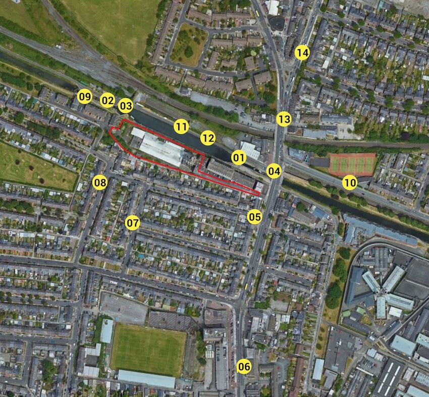
1.3.1 Landscape/townscape Impact Assessment Criteria
When assessing the potential impacts on the townscape resulting from a proposed development,
the following criteria are considered:

    •   Landscape/townscape character, value and sensitivity;

    •   Magnitude of likely impacts;

    •   Significance of landscape effects.
The sensitivity of the townscape to change is the degree to which a particular setting can
accommodate changes or new elements without unacceptable detrimental effects to its essential
characteristics. Landscape/townscape Value and Sensitivity is classified using the following criteria set
out in Table 1-1.
Table 1-1: Landscape/Townscape Value and Sensitivity

Sensitivity      Description

Very High        Areas where the townscape character exhibits a very low capacity for change in
                 the form of development. Examples of which are high value townscapes,
                 protected at an international or national level (e.g. World Heritage Site), where
                 the principal management objectives are likely to be protection of the existing
                 character.

High             Areas where the townscape character exhibits a low capacity for change in the
                 form of development. Examples of which are high value townscapes, protected at
                 a national or regional level, where the principal management objectives are likely
                 to be considered conservation of the existing character.

Medium           Areas where the townscape character exhibits some capacity and scope for
                 development. Examples of which are townscapes, which have a designation of
                 protection at a county level or at non-designated local level where there is
                 evidence of local value and use.

Low              Areas where the townscape character exhibits a higher capacity for change from
                 development. Typically, this would include lower value, non-designated
                 townscapes that may also have some elements or features of recognisable quality,
                 where management objectives include, enhancement, repair and restoration.

Negligible       Areas of townscape character that include derelict sites and degradation where
                 there would be a reasonable capacity to embrace change or the capacity to
                 include the development proposals. Management objectives in such areas could
                 be focused on change, creation of townscape improvements and/or restoration.

                                                                                                       4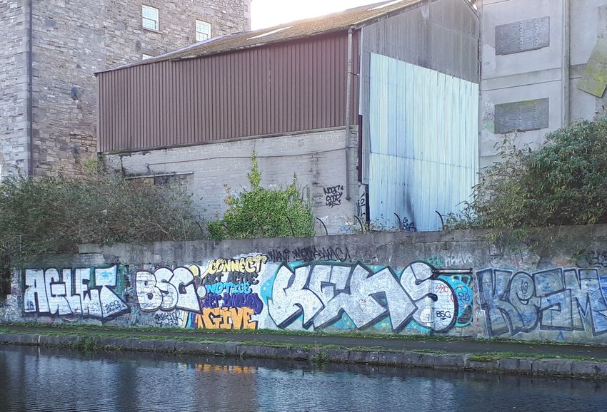
The magnitude of a predicted landscape/townscape impact is a product of the scale, extent or
degree of change that is likely to be experienced as a result of the proposed Development. The
magnitude takes into account whether there is a direct physical impact resulting from the loss of
landscape/townscape components and/or a change that extends beyond the immediate setting that
may have an effect on the townscape character. Table 1-2 refers.
Table 1-2: Magnitude of Landscape/Townscape Impacts

Sensitivity   Description

Very High     Change that would be large in extent and scale with the loss of critically important
              landscape elements and features, that may also involve the introduction of new
              uncharacteristic elements or features that contribute to an overall change of the
              townscape in terms of character, value and quality.

High          Change that would be more limited in extent and scale with the loss of important
              townscape elements and features, that may also involve the introduction of new
              uncharacteristic elements or features that contribute to an overall change of the
              townscape in terms of character, value and quality.

Medium        Changes that are modest in extent and scale involving the loss of landscape
              characteristics or elements that may also involve the introduction of new
              uncharacteristic elements or features that would lead to changes in landscape
              character, and quality.

Low           Changes affecting small areas of landscape character and quality, together with
              the loss of some less characteristic landscape elements or the addition of new
              features or elements.

Negligible    Changes affecting small or very restricted areas of landscape character. This may
              include the limited loss of some elements or the addition of some new features
              or elements that are characteristic of the existing landscape or are hardly
              perceivable.

Positive      Changes that restore a degraded landscape or reinforce characteristic landscape
              elements.

The significance of a landscape/townscape impact is based on a balance between the sensitivity of
the landscape receptor and the magnitude of the impact. The significance of landscape impacts is
arrived at using the following matrix set out in Table 1-3.

                                                                                                     5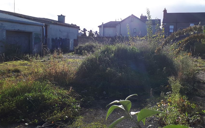
Table 1-3: Impact Significance Matrix

Note: The significance matrix provides an indicative framework from which the significance of
impact is derived. The significance judgement is ultimately determined by the assessor using
professional judgement. Due to nuances within the constituent sensitivity and magnitude
judgements, this may be up to one category higher or lower than indicated by the matrix.
Judgements indicated in orange are considered to be ‘significant impacts’ in EIA terms.

1.3.2   Visual Impact Assessment Criteria

As with the landscape/townscape impact, the visual impact of the proposed Development will be
assessed as a function of sensitivity versus magnitude. In this instance the sensitivity of the visual
receptor, weighed against the magnitude of the visual effect.

                                                                                                    6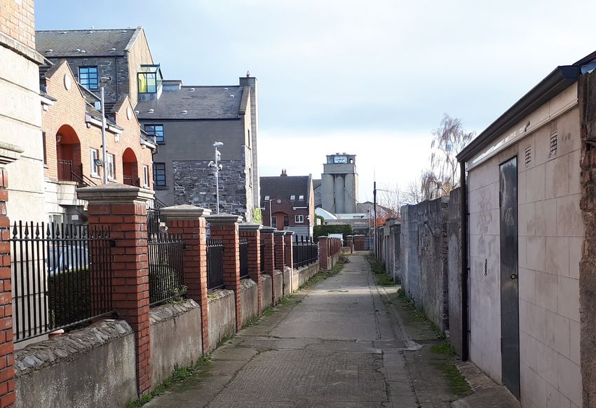
Sensitivity of Visual Receptors

Unlike landscape sensitivity, the sensitivity of visual receptors has an anthropocentric (human) basis.
It considers factors such as the perceived quality and values associated with the view, the
landscape/townscape context of the viewer, the likely activity they are engaged in and whether this
heightens their awareness of the surrounding landscape. A list of the factors considered by the
assessor in estimating the level of sensitivity for a particular visual receptor is outlined below to
establish visual receptor sensitivity at each VRP:

Susceptibility of Receptors

In accordance with the Institute of Environmental Management and Assessment (“IEMA”) Guidelines
for Landscape and Visual Assessment (3rd edition 2013) visual receptors most susceptible to changes
in views and visual amenity are:

•   “Residents at home;

•   People, whether residents or visitors, who are engaged in outdoor recreation, including use of
    public rights of way, whose attention or interest is likely to be focussed on the landscape and on
    particular views;

•   Visitors to heritage assets, or to other attractions, where views of the surroundings are an
    important contributor to the experience;

•   Communities where views contribute to the landscape setting enjoyed by residents in the area;

•   Travellers on road rail or other transport routes where such travel involves recognised scenic
    routes and awareness of views is likely to be heightened”.

Visual receptors that are less susceptible to changes in views and visual amenity include;

•   “People engaged in outdoor sport or recreation, which does not involve or depend upon
    appreciation of views of the landscape;

•   People at their place of work whose attention may be focussed on their work or activity, not their
    surroundings and where the setting is not important to the quality of working life”.

Recognised scenic value of the view (County Development Plan designations, guidebooks, touring
maps, postcards etc). These represent a consensus in terms of which scenic views and routes within
an area are strongly valued by the population because in the case of County Developments Plans, for
example, a public consultation process is required;

Views from within highly sensitive townscape areas. These are likely to be in the form of
Architectural Conservation Areas, which are incorporated within the Development Plan and
therefore subject to the public consultation process. Viewers within such areas are likely to be highly
attuned to the townscape around them;

Primary views from residential receptors. Even within a dynamic city context views from residential
properties are an important consideration in respect of residential amenity;

Intensity of use, popularity. This relates to the number of viewers likely to experience a view on a
regular basis and whether this is significant at a national or regional scale;

                                                                                                     7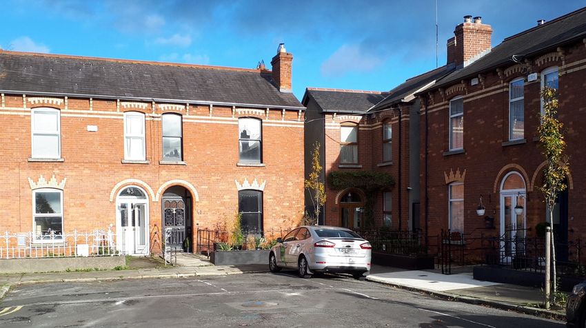
Viewer connection with the townscape. This considers whether or not receptors are likely to be
highly attuned to views of the townscape i.e. commuters hurriedly driving on busy roads versus
tourists focussed on the character and detail of the townscape;

Provision of vast, elevated panoramic views. This relates to the extent of the view on offer and the
tendency for receptors to become more attuned to the surrounding landscape at locations that
afford broad vistas;

Sense of remoteness and/or tranquillity. Receptors taking in a remote and tranquil scene, which is
likely to be fairly static, are likely to be more receptive to changes in the view than those taking in
the view of a busy street scene, for example;

Degree of perceived naturalness. Where a view is valued for the sense of naturalness of the
surrounding landscape it is likely to be highly sensitive to visual intrusion by distinctly manmade
features;

Presence of striking or noteworthy features. A view might be strongly valued because it contains a
distinctive and memorable landscape / townscape feature such as a cathedral or castle;

Historical, cultural and / or spiritual significance. Such attributes may be evident or sensed by
receptors at certain viewing locations, which may attract visitors for the purposes of contemplation
or reflection heightening the sense of their surroundings;

Rarity or uniqueness of the view. This might include the noteworthy representativeness of a certain
townscape type and considers whether the receptor could take in similar views anywhere in the
broader region or the country;

Integrity of the townscape character. This looks at the condition and intactness of the townscape in
view and whether the townscape pattern is a regular one of few strongly related components or an
irregular one containing a variety of disparate components;

Sense of place. This considers whether there is special sense of wholeness and harmony at the
viewing location;

Sense of awe. This considers whether the view inspires an overwhelming sense of scale or the power
of nature.

Those locations which are deemed to satisfy many of the above criteria are likely to be of higher
sensitivity. No relative importance is inferred by the order of listing. Overall sensitivity may be a
result of a number of these factors or, alternatively, a strong association with one or two in
particular.

1.3.3      Visual Impact Magnitude

The visual impact magnitude relates to the scale and nature of the visual change brought about by
the proposal and this is reflected in the criteria contained in Table 1.4 below.

Table 1.4: Magnitude of Visual Impacts

Criteria       Description

                                                                                                     8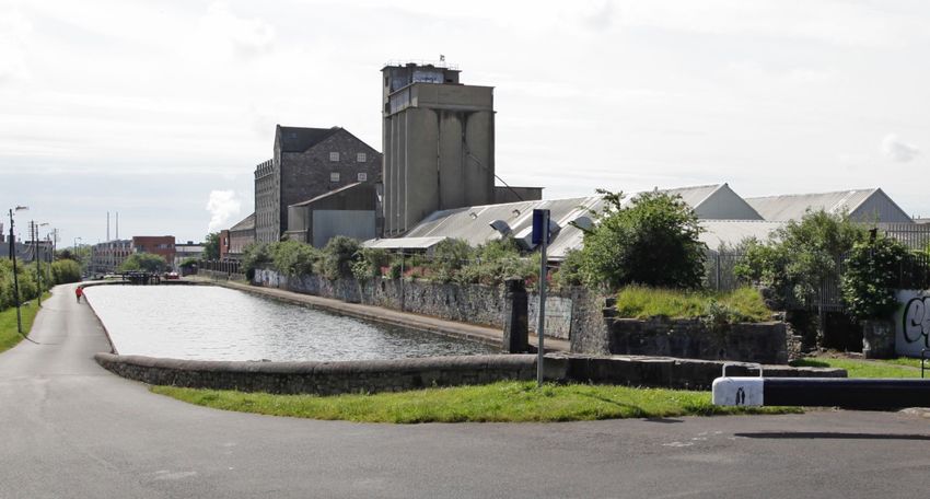
Very High    The proposal alters a large proportion or critical part of the available vista and is
             without question the most distinctive element. A high degree of visual clutter or
             disharmony is also generated, strongly reducing the visual amenity of the scene

High         The proposal alters a significant proportion or important part of the available vista and
             is one of the most noticeable elements. A considerable degree of visual clutter or
             disharmony is also likely to be generated, appreciably reducing the visual amenity of
             the scene

Medium       The proposal represents a moderate alteration to the available vista, is a readily
             noticeable element and/or it may generate a degree of visual clutter or disharmony,
             thereby reducing the visual amenity of the scene.

Low          The proposal alters the available vista to a minor extent and may not be noticed by a
             casual observer and/or the proposal would not have a marked effect on the visual
             amenity of the scene.

Negligible   The proposal would be barely discernible within the available vista and/or it would not
             detract from, and may even enhance, the visual amenity of the scene.

Positive     Changes that enhance the available vista by reducing visual clutter or restoring
             degraded features.

1.3.4   Visual Impact Significance

As stated above, the significance of visual impacts is a function of visual receptor sensitivity and
visual impact magnitude. This relationship is expressed in the same significance matrix and applies
the same EPA definitions of significance as used earlier in respect of townscape impacts (Table 1-3
refers).

1.3.5      Extent of Study Area

It is anticipated that the proposed development is not likely to give rise to significant
landscape/townscape or visual impacts beyond approximately 1km. As a result, a 1km-radius study
area is used in this instance.

                                                                                                     9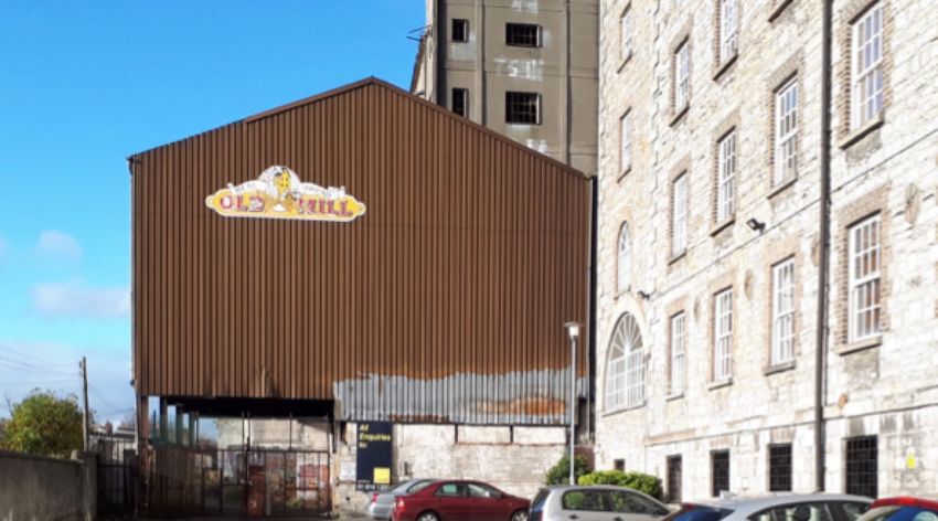
Figure 1.0 - Study area for the proposed development

1.4     THE RECEIVING ENVIRONMENT
The landscape/townscape baseline represents the existing context and is the scenario against which
any changes to it, brought about by the proposed development, will be assessed. A description of
the landscape/townscape context of the proposed site and wider study area is provided below.
Although this description forms part of the landscape/townscape baseline, many of the elements
identified also relate to visual receptors i.e. places from which viewers can potentially see the
proposed Development. The visual resource will be described in greater detail in Section 1.9.

1.4.1   Baseline Environment

1.4.1.1 Immediate Site Context
This brownfield site area covers 0.7 ha. and is known locally as the “Old Bakery Site.” It has a
relatively long, narrow profile, running in a northwest/southeast direction. It is located along the

                                                                                                 10
southern bank of the Royal Canal, with access onto Phibsborough Road by Cross Guns Bridge (i.e.
over the Royal Canal). A large, former bakery occupies the site, which has been derelict for more
than 35 years. A greenfield site until approx. 1840, a foundry was then constructed on the site, but
was soon converted into a flourmill in the 1860s. However, a new flourmill was constructed on the
site in the 1930s, with a large concrete silo constructed in the 1950s. Accordingly, the 20th Century
post-industrial environment within the site comprises of large, obsolete buildings, dominated by a
30m-high concrete silo, with lower (i.e. 8m high), dilapidated, warehouse-style buildings abutting its
eastern and western flank (see Figure 1.1, below). On the far western end of the site is an exterior,
hardscape area where vegetation has been recolonizing for several years (see Figure 1.5, below).
In terms of boundary treatment, on its northern side a stonewall separates the site from the
towpath at Cross Guns Quay along the Royal Canal (see Figure 1.2, below). Along its western and
southern boundaries, residential development is present, ranging from modern housing
developments (i.e. to the west) to two-storey, redbrick Victorian terraced housing (to the southwest
and south) (see Figure 1.4, below). To the immediate south of the site, behind Leinster Street, a
gated/secured residential back lane separates these properties from the site boundary. The site
‘pinchers’ along its eastern end, where the vehicular entrance from Phibsborough Road marks the
eastern edge of the site. Also along the south bank of the canal, the Mill apartment complex is
located in a converted/refurbished 19th Century, 23m-tall stone mill building (and protected
structure), abutting the north-eastern end of the site. In that regard, the site and its immediate
context is that of an urban, multi-storey commercial and/or residential character (see Figure 1.6,
below).
The most defining feature of the immediate site context is that of the Royal Canal, whose 200-year
old towpath serves as a recreational hub and transport axis for the community’s walkers, runners,
cyclists and fisherfolk (see Figure 1.8, below). Cyclists and walkers commuting to/from or connecting
with Dublin city centre, which is located within 2km of the site, also heavily frequent the towpath.
Six different canal gates are present within 100m of the site (three to the northwest; three to east).
Figure 1.1 – View of the ‘Old Bakery Site’ on the far (i.e. south) side of the Royal Canal.
11Figure 1.2 – A stonewall separates the site from the towpath at Cross Guns Quay along the Royal Canal
Figure 1.3 – A residential ‘back lane’ to the west of the site. Please note the 30m-high, 1950’s concrete silo in
the centre distance, which is proposed to be demolished as part of the proposed development.
12Figure 1.4 – two-storey, redbrick Victorian terraced housing is prevalent to the immediate southwest and
south of the site.
Figure 1.5 – On the far western end of the site is a former concrete slab yard where vegetation has been
recolonizing for three decades,
13Figure 1.6 – Much of the eastern end of the site is currently used as a car park for the Mill apartment block
(i.e. to the right/ north of the frame). The former bakery buildings, which are proposed to be demolished,
are located at the western end of this car park, and are inaccessible to the public.
1.4.1.2 Broader Townscape Context
The site is located near the heart of Phibsborough, an inner suburb of Dublin city with a long
established, mixed commercial and residential neighbourhood. Its topography is either flat or slightly
undulating, gravitating close to the 50m AOD contour. The most notable natural watercourse within
1km of the site is the Tolka River, approx. 1km north/northeast, in Drumcondra and Glasnevin, while
the closest manmade watercourse, the Royal Canal, runs adjacent to the site’s northern boundary.
There are numerous important transport routes within 500m of the site, notably the R135, which
links in with the southern end of the N2, and the R147/Navan Road, which links in with the southern
end of the N3, both of which also serve as busy suburban roads for the community. Two major rail
lines are within 100m north of the site (see Figure 1.7, above): the Western commuter Services line
that runs between Pearse Street Station and Maynooth, as well as the Dublin Connolly to Longford/
Sligo line. In addition, the Luas Green Line runs within 500m southwest of the site.
Phibsborough’s character and sense of place within the study area is substantially threefold, which is
reflective of its adaptability, growth and popularity over the last two centuries. Firstly, a
commercial/transport nexus is centred along Phibsborough Road/Botanic Road, adjacent to the
eastern end of the site. Aside from multi-storey residential blocks such as The Mill (adjacent to the
site), this corridor hosts numerous commercial and retail industries - from relatively recent cafes and
restaurants to multi-generational family businesses - in tandem with the aforementioned, intensely
used transport routes. This includes the large, eight-storey Phibsborough Shopping Centre, which
was built in the 1960s and is located within 200m south of the site. In 2018, a €50 million revamp of
the shopping centre was approved by An Bord Pleanála last. This nexus also entails the sizeable,
multi-storey infrastructure of both Mountjoy Prison and the Mater Hospital, located within 200m
and 500m southeast of the site, respectively.
14Secondly, the prevalence of 19th Century, Victorian housing, which is frequently terraced, helps
engender a more sedate and serene sense of place, which has attracted residents to the area for
over a century. An Architectural Conservation Area is located approx. 350m south of the site, along
North Circular Road, although most of these 19th Century buildings are in commercial/retail, rather
than residential, use.
Thirdly, the Royal canal and the broader recreational facilities and amenities also characterise the
study area. Aside from the aforementioned draw of the Royal Canal corridor (see Figure 1.8 below),
nearby there is also the National Botanic Gardens and the renowned Glasnevin cemetery, as well as
Dalymount Park, home of Bohemian F.C, with its attendant large supporter stands, located within
250m south of the site. This trifold of factors is non-unrelated as to why Phibsborough was listed in
October 2020 as one of the top 40 'coolest neighbourhoods' in the world, according to the
international Time Out magazine.
Figure 1.7 – Two major rail lines run within north 100m north of the site
Figure 1.8 – the Royal Canal corridor is particularly popular with the community’s walkers, runners, cyclists
and fisherfolk.
151.5 PLANNING CONTEXT
1.5.1 Dublin City Development Plan (CDP) 2016-2022
In terms of land use zoning (Map E of the Dublin CDP) the proposed development is contained in
‘Zone Z1’, whose zoning objective is to “to protect, provide and improve residential amenities.”
There are no additional zoning objectives relevant to the site.
Application Site
Figure 1.9 – extract of Map E of the Dublin CDP, showing how the site is contained within ‘Z1’ designation.
Chapter 4 – ‘Shape and Structure of the City’ of the Dublin City Development Plan (2016-2022)
contains relevant policies in respect of Dublin’s inner suburbs and outer city. The site is located
within 200m of a “Key District Centre,” although the site itself is not within one. In relation to Key
District Centres, Section 4.5.2.1 of the CDP states:
“As the top tier of urban centres outside the city centre, these will be strong spatial hubs,
providing for a comprehensive range of commercial and community services […] While
some of KDCs may have an established urban form, these centres should also be capable
of achieving a distinctive spatial identity with a high quality physical environment.”
Policies and objectives relating to the inner suburbs and outer city are outlined within Chapter 4 of
the development plan.
16Policies relevant to the proposed development
SC5: To promote the urban design and architectural principles set out in Chapter 15,
and in the Dublin City Public Realm Strategy 2012, in order to achieve a quality,
compact, well-connected city.
SC10: To develop and support the hierarchy of the suburban centres, ranging from
the top tier key district centres, to district centres/urban villages and
neighbourhood centres, in order to support the sustainable consolidation of the
city and provide for the essential economic and community support for local
neighbourhoods, including post offices and banks, where feasible, and to promote
and enhance the distinctive character and sense of place of these areas.
SC12: To ensure that development within or affecting Dublin’s villages protects their
character.
Objectives relevant to the proposed development
SC04: To undertake a views and prospects study, with the aim of compiling a list of
views and prospects for protection and/ or enhancement which will be integrated
with and complement the urban form and structure of the city.
Approach to Taller Buildings
Section 4.5.4.1 specifically deals with the ‘Approach to Taller Buildings’ and begins
with the statement that:
“Dublin City Council acknowledges the intrinsic quality of Dublin as a low-rise city
and considers that it should remain predominantly so. The vast majority of the city
area is identified as not being suitable for mid-rise or taller buildings. The City
Council remains committed to the need to protect conservation areas,
architectural conservation areas and the historic core of the city. However, taller
buildings can also play an important visual role and can make a positive
contribution to the skyline of a city. Dublin City Council recognises the merit of taller
buildings, including landmark buildings, in a very limited number of locations at a
scale appropriate for Dublin.”
Relevant Policy in relation to building height includes;
SC16: To recognise that Dublin City is fundamentally a low-rise city and that the
intrinsic quality associated with this feature is protected whilst also recognising the
potential and need for taller buildings in a limited number of locations subject to the
provisions of a relevant LAP, SDZ or within the designated strategic development
regeneration area (SDRA).
17SC18: To promote a co-ordinated approach to the provision of tall buildings through
local area plans, strategic development zones and the strategic development and
regeneration areas principles, in order to prevent visual clutter or cumulative
negative visual disruption of the skyline.
Designated Scenic Views and Prospects
Also contained within Chapter 4 is a map illustrating views and prospects for protection. However,
there are no designated views and prospects within the study area.
1.5.2 Urban Development and Building Heights – Guidelines for Planning Authorities (December
2018)
The Urban Development and Building Guidelines were adopted in December 2018 by the Minister for
Housing, Planning and Local Government “to secure better and more compact forms of future
development.”
Policies stated within the UDBH guidelines that may be relevant to the proposed development are
included below:
SPPR1: In accordance with Government policy to support increased building height
in locations with good public transport accessibility, particularly town/city cores,
planning authorities shall explicitly identify, through their statutory plans, areas
where increased building height will be actively pursued for both redevelopment
and infill development to secure the objectives of the National Planning
Framework and Regional Spatial and Economic Strategies and shall not provide for
blanket numerical limitations on building height.
SPPR 2: In driving general increases in building heights, planning authorities shall
also ensure appropriate mixtures of uses, such as housing and commercial or
employment development, are provided for in statutory plan policy. Mechanisms
such as block delivery sequencing in statutory plans² could be utilised to link the
provision of new office and residential accommodation, thereby enabling urban
redevelopment to proceed in a way that comprehensively meets contemporary
economic and social needs, such as for housing, offices, social and community
infrastructure, including leisure facilities.
Section 3.2 of the UDBH guidelines also lists development management criteria from the city/town
scale to the site/building scale in which “the applicant shall demonstrate to the satisfaction of the
Planning Authority/ An Bord Pleanála, the proposed development satisfies the following criteria…”
Those criteria deemed relevant to this visual impact assessment and the proposed development
are included below.
At the scale of the relevant city/town:
18• Development proposals incorporating increased building height, including
proposals within architecturally sensitive areas, should successfully integrate
into/ enhance the character and public realm of the area, having regard to
topography, its cultural context, setting of key landmarks, protection of key
views. Such development proposals shall undertake a landscape and visual
assessment, by a suitably qualified practitioner such as a chartered landscape
architect.
• On larger urban redevelopment sites, proposed developments should make a
positive contribution to place-making, incorporating new streets and public
spaces, using massing and height to achieve the required densities but with
sufficient variety in scale and form to respond to the scale of adjoining
developments and create visual interest in the streetscape.
1.6 Identification of Viewshed Reference Points as a Basis for Assessment
Viewshed Reference Points (VRP’s) are the locations used to study the likely visual impacts
associated with the proposed development. It is not warranted to include each and every location
that provides a view as this would result in an unwieldy report and make it extremely difficult to
draw out the key impacts arising from the proposed development. Instead, the selected viewpoints
are intended to reflect a range of different receptor types, distances and angles. The visual impact of
a proposed development is assessed using up to 6 categories of receptor type as listed below:
• Key Views - from features of national or international importance;
• Designated Scenic Routes and Views;
• Local Community views;
• Centres of Population;
• Major Routes;
• Amenity and heritage features.
The Viewshed Reference Points selected in this instance are set out in Table 1.5 and shown on Figure
1.10 below.
19Figure 1.10 – Viewpoint Selection Map
Table 1-5 Outline Description of Selected Viewshed Reference Points (VRPs)
VRP No. Location Direction
of view
VP1 Royal Canal Way, looking northwest NW
VP2 Royal Canal Way, looking southeast SE
VP3 Royal Canal Way, looking south S
VP4 Phibsborough Road by Royal Canal Way NW
20VP5 Junction of Phibsborough Road and Leinster Street North NW
VP6 Phisborough road by Phibsborough Shopping Centre N
VP7 Ulster Street N
VP8 Shandon Road N
VP9 Royal Canal Way, looking southeast SE
VP10 Whitworth Road W
VP11 Royal Canal Way, looking southeast SE
VP12 Royal Canal Way, looking southwest SW
VP13 Botanic Road near Cross Guns Bridge SW
VP14 Botanic Road by Finglas Road junction SW
1.7 PREDICTED IMPACTS
1.7.1 Landscape/townscape Impacts
1.7.1.1 Landscape/townscape value and sensitivity
In accordance with Section 5.5 of the GLVIA-2013, a townscape character assessment requires a
particular understanding of, among other criteria, “the context or setting of the urban area and its
relationship to the wider landscape.” In a city that has evolved over millennia, the study area is a
relatively recent addition. Phibsborough’s sense of place has strong overlaps with other of Dublin’s
redbrick inner suburbs that were developed primarily through the 19th Century, engendering a
balance between proximity to the city centre with palpable professional, community and
recreational opportunities, set along numerous aforementioned transport routes. As previously
covered in Section 1.6.1.2, its character has also been informed by a trifold of factors: a
commercial/transport nexus centred the Phibsborough Road corridor, where multi-storey
commercial, institutional and residential use commonly occurs; the prevalence of 19th Century,
Victorian housing, which is frequently terraced; and, lastly, the Royal canal and the broader
recreational facilities and amenities that populate the study area.
In this regard, the site and its immediate surrounds (i.e. within 100m) are hugely and highly
representative of the suburb of Phibsborough, in that it lies at an intersection of major transport
nodes, the Phibsborough Road commercial corridor and the royal canal corridor, while being less
than 100m from streets of 19th Century redbrick housing. In terms of built form in the immediate
21area there is complex and eclectic array of buildings of different sizes and styles marking their
various periods. While Dublin City attracts large volumes of tourists and visitors in the course of a
year, and much of the draw relates to its low-rise townscape character, neither of these factors is
evident within the study area. Aside from the Botanic Gardens and soccer-supporters attending
Dalymount Park, there is a dearth of tourist/visitors attractions within the study area, while there
are, as previously covered, several multi-storey commercial, residential buildings present.
Regarding sensitivity, this is an evolving townscape subject to near constant changes in the built
environment and thus, it is not inherently sensitive to change. While there is an Architectural
Conservation Area designation located approx. 350m south of the site, this is not reflective of the
built environment in the vicinity of the site.
On balance of the factors outlined above, the sensitivity of the receiving townscape setting is
considered to be Medium-low.
1.7.1.2 Magnitude of Landscape/townscape effects
Construction Phase
There will be permanent physical effects to the land cover of the site, which are not readily
reversible. During the construction stage of the proposed development, which is estimated to take
24 months, there will be intense construction-related activity within and around the site, including
approach roads. This will include, but is not limited to:
• HGVs transporting materials to and from the site;
• Movement of heavy earth-moving machinery and tower cranes on-site;
• Temporary storage of excavated materials and construction materials on-site;
• Gradual emergence of the proposed apartment complex, and associated works;
• Security fencing and site lighting.
Whilst the physical impacts to the site’s land cover will be permanent, and not readily reversible, the
site is already a much-modified, brownfield, post-industrial site that does not enrich the overall
landscape character of the area. Construction stage impacts on landscape/townscape character will
be ‘short-term’ (i.e. lasting 1-7 years), in accordance with the EPA definitions of impact duration.
Furthermore, the context of this construction activity is within the grounds of an urban centre where
such activity is a regular occurrence.
On the basis of the reasons outlined above, the magnitude of construction stage
landscape/townscape impacts is deemed to be Medium. When combined with the Medium-low
sensitivity of the receiving landscape, the overall significance of construction stage
landscape/townscape impacts is considered to be Moderate, in accordance with the criteria
contained in Section 1.5.
Operational Phase
Following the completion of the proposed works, landscape/townscape impacts will relate entirely
to the development’s impact on the character of the receiving landscape/townscape and whether
this is positive or negative.
22The most notable landscape/townscape impacts of the application site will result from the
permanent 3 no. blocks ranging in height from 4 storeys to 12 storeys. The 9.63m increase in height
from the roof of the concrete silo currently on site, to that of the tallest proposed building is worthy
of note, but is, nonetheless, not a substantial increase (i.e. an increase from 30.37m to 40.0m, for
the tallest of the three proposed blocks, with the remaining two blocks being less than 27m height).
However, it does represent a continuation of, and compatibility with, the existing land use and
townscape fabric and character within the study area, where multi-storey residential blocks are
present. These include the 23m-tall The Mill apartment block, abutting the north-eastern end of the
site, but also the multi-storey infrastructure of several aforementioned buildings (in Section 1.6.1.2)
within 500m of the site. Upon completion of construction, one of the three proposed blocks will
become the tallest multi-storey development in the locality, marking an escalation and
intensification of that fabric within the study area, while being attuned to and compatible with it.
In terms of the broader effects on landscape/townscape character, the proposal represents the
maintenance of an established, multi-storey residential use that already feeds into the character of
its immediate environs. Whilst the proposal will result in a distinct increase in the scale and intensity
of development within the application site, and its immediate surrounds, such a development is to
be expected in a vibrant, dynamic and evolving settlement inner suburb such as Phisborough, and
will knit into the prevailing urban fabric rather than contrasting against it.
For the reasons outlined above, the magnitude of operational stage landscape/townscape impacts
is considered to be Medium-Low.
1.8.1.3 Significance of Landscape/townscape effects
In accordance with the Landscape/Visual significance matrix contained in Table 1.3, the combination
of a ‘Medium-low’ townscape sensitivity judgement and a ‘Medium-low’ townscape impact
magnitude judgment results in a ‘Moderate-slight’ overall significance of townscape impact.
1.8 VISUAL IMPACT ASSESSMENT
1.8.1 Visual Receptor Sensitivity
In consideration of the visual receptor criteria set out in section 1.4.1, the main variation in the
nature of views and those availing of those views, in this instance, relates to an overt sense of place.
As previously set out in Section 1.6.1.2, Phibsborough’s character and sense of place is substantially
threefold within the study area. Accordingly, the resulting visual receptor sensitivity of all 14
viewpoints will be informed by this.
To begin with, the most sensitive receptors/viewpoints are deemed to be those on the Royal Canal
corridor. As with many canal-based views from about the city and country, while these are “heritage
based” (i.e. an 18th canal and tow path), they are also frequently subject to conspicuous
development from subsequent centuries in the direct vicinity. In the case of the Royal Canal, this
includes the aforementioned 23m-tall Mill apartment block, Mountjoy Prison and one of the largest
sporting stadia in Europe: Croke Park, 1.4km southeast of the site. On balance, views along this
receptor (i.e. VPs 1, 2, 3, 9, 11, 12) are deemed to be of ‘Medium’ visual sensitivity.
Views from along two-storey, 19th Century, red brick residential streets are also overtly “heritage
based,” and engender a richly residential and sedate sense of place. Yet these streets have been
23subject to conspicuous development in their immediate vicinity (i.e. the 1960s eight-storey
Phibsborough Shopping Centre). Overall, views within this receptor (i.e. VPs 7 & 8) are deemed to be
of ‘Medium-low’ visual sensitivity.
Similar or less sensitive receptors are considered to occur along the commercial/transport nexus
centred along Phibsborough Road/Botanic Road (i.e. VPs 4, 5, 6, 10, 13, 14). In general, busy city
streets heavily influence these less iconic streetscapes with retail uses at the street level. Whilst
there can be a character or charm to views from such receptors, there is less inherent visual amenity
to hand than other receptors in the study area. Thus, along this receptor a ‘Medium-low’ or ‘Low’
visual receptor sensitivity is attributed, as viewpoint locations vary between the commercial hub
near Phibsborough Road’s junction with North Circular Road, graduating to more redbrick residential
character closer to Botanic Road.
1.8.2 Magnitude of Visual Effect
The assessment of visual impacts at each of the selected viewpoints is aided by photomontages of
the proposed development. Photomontages are a ‘photo-real’ depiction of the scheme within the
view, utilising a rendered three-dimensional model of the development, which has been geo-
referenced to allow accurate placement and scale. For each viewpoint, the following images have
been produced:
1. Existing View
2. Montage View upon completion of proposed works
Viewshed Reference Point Viewing distance Direction of
to site boundary View
VP1 Royal Canal Way, looking northwest 42m NW
Representative of:
• Local community views
• Commuters/walkers/runners/cyclists
Receptor Sensitivity Medium
Existing View By way of context, this location along the Royal Canal Way is adjacent to
Lock 5. Royal Canal Way has long served as a recreational hub and transport
axis for the community’s walkers, runners and cyclists, including commuters
connecting with Dublin city centre.
In this view, the looming presence of the Mill apartment block is
conspicuous to the southern side of the canal. It’s six-storey (plus basement)
profile sits adroitly against the even, level planes of the Royal Canal and
attendant towpath. At the western end of this former 19th Century mill, a
24strong vertical seam is marked by a castle tower-like termination, beyond
which the derelict concrete silo reads, from this angle, as an ill-fitting 20th
Century extension to the site. Within the site, behind a much-graffitied
stonewall, the dilapidated, warehouse-style buildings and unkempt
vegetation of the site can be seen, in stark contrast to the well
managed/maintained Mill apartment block. Furthermore, west of the
concrete silo there is a discernible ‘gap’ in the canal-side urban fabric until
the lower storey of Shandon Mill (residential complex) can be spied
alongside Lock 6, approx. 200m away. In the immediate foreground, the tip
of the canal gates of Lock 5 is also apparent.
Visual Impact of Over 40m away, the proposed contemporary, multi-storey residential block,
proposed exceeding, in places, the height of the Mill apartment block, will be
development conspicuous. Following the demolition and removal of the large, derelict and
unattractive buildings on site, the proposed buildings will dramatically
change this canal bank scene, but the degree of visual change is not
tantamount to the degree of visual impact. Firstly, the presence of the
proposed buildings will not obscure or obstruct more distant views of any
aesthetic merit. Secondly, there will be a more consistent degree of visual
enclosure when viewed from this section of the Royal Canal Way, in tandem
with a noticeable increase in the scale and intensity of built development
overall.
Nonetheless, the proposed buildings will represent consolidation of the
inconsistent building line and gap filling along this urban canal bank,
between the Mill apartment block and Shandon Mill (residential complex).
Tall and contemporary, the proposed buildings will permeate a high quality
finish and light-infused fenestration that complements the reflective, calm
waters of the canal, while aptly contrasting and off-setting the more
muscular, multi-storey 19th century stone hulk to its immediate east.
For the reasons outlined above the magnitude of visual impact is deemed to
be Medium-low.
Summary Based on the assessment criteria and matrices outlined at Section 1.3 the
significance of residual visual impact is summarised below.
Visual Receptor Visual Impact Significance of Visual
Sensitivity Magnitude Impact
Impact Significance Medium Medium-low Moderate-slight
Viewshed Reference Point Viewing distance to Direction of
25site boundary View
VP2 Royal Canal Way, looking southeast 45m SE
Representative of:
• Local community views
• Commuters/walkers/runners/cyclists
Receptor Sensitivity Medium
Existing View This location along the Royal Canal Way is adjacent to Lock 6, 45m north of
the northwest corner of the site. The still, reflective waters of the Royal
Canal fasten the visual amenity of this urban scene, with the gates of Lock 6
in the immediate foreground. The three-storey Shandon Mill (residential
complex) is noticeable to the south of Lock 6, with the clean lines of it’s
gable end foreshadowing more distant gable ends to its east. To the
rear/east of Shandon Mill, the warehouse-style buildings and unkempt
vegetation of the site can be seen, which are abutted on their eastern end
by a tall, industrial-looking concrete silo, beyond which sits the 19th-Century,
multi-storey Mill apartment block. Further east, lower, multi-storey
residential development can be spied, along with Mountjoy Prison and the
Poolbeg’s iconic “chimney” towers. North of the Royal canal Way (i.e. to the
left of this scene), the absence of even modest-sized built development is
notable, in light of this inner-suburb city setting (i.e. Dublin City centre being
within 2km of this location).
Visual Impact of From this angle and location, the proposed buildings will stamp a
proposed conspicuous vertical imprint on this scene, but without detracting from the
development inherent visual amenity of this waterside setting, which was and remains
derived from the canal. There will be a visible ‘tiering’ in height of the
proposed blocks, from Shandon Mill eastwards, which will also soften any
potential massing of these large structures. The nearest proposed block will
be similarly “stacked” as it descends on it’s southern side, while its bright
gable end will link-in with that of Shandon Mill in the foreground.
Although generating a hard-to-miss increase in the concentration of built
development along the canal bank, the proposal will incur substantial visual
change to the scene but without obscuring or obstructing more distant
views of any aesthetic value. Similar to the Mill apartment block on its
eastern end, the clean lines of the proposed blocks will inform a sharp
perpendicular profile (i.e. the transition between vertical and horizontal
planes) fitting for such an urban waterway.
For the reasons outlined above the magnitude of visual impact is deemed to
be Medium-low.
26Summary Based on the assessment criteria and matrices outlined at Section 1.3 the
significance of residual visual impact is summarised below.
Visual Receptor Visual Impact Significance of Visual
Sensitivity Magnitude Impact
Impact Significance Medium Medium-low Moderate-slight
Viewshed Reference Point Viewing Direction of
distance View
VP3 Royal Canal Way, looking south 28m S
Representative of:
• Local community views
• Commuters/walkers/runners/cyclists
Receptor Sensitivity Medium
Existing View This location is along the Royal Canal Way and is also adjacent to Lock 6,
28m north of the northwest corner of the site. This view is centred upon the
rear gardens of the three-storey Shandon Mills, behind which, and mostly
out of site, is a hardscape yard-like facility within the western end of the
site, which has largely been recolonized by vegetation in recent decades.
Further east are the relatively low (i.e. approx. 8m high) dilapidated,
warehouse-style buildings within the site. In the foreground are the
marooned ruins of a stone buttress latterly constructed within the canal,
and which once supported a rail line in the late 19th Century, linking the
major rail lines within 50m north of this location with the flourmill then
occupying the site of the proposed development. Although a canal bank
setting, this view offers a somewhat limited degree of visual amenity, even
for an urban context.
Visual Impact of Viewed from this angle, the transition between the seven-storey, proposed
proposed western block and the existing residences at the three-storey Shandon Mills
development will be softened by the ‘tiering’ of the block, so that it graduates from four-
storeys to seven, rather than a single, abrupt transition. Be that as it may,
the proposed block appears to be visually dominating, in its immediate
context of Shandon Mills. The proposed development will mark a stark
degree of visual change in this view, but without markedly decreasing the
hitherto limited degree of visual amenity. Tall and contemporary, the
27proposed block will permeate a high quality finish and fenestration,
generating a distinctively residential tone, with its bright gable end tying-in
with that of Shandon Mill.
For the reasons outlined above the magnitude of visual impact is deemed to
be Medium.
Summary Based on the assessment criteria and matrices outlined at Section 1.3 the
significance of residual visual impact is summarised below.
Visual Receptor Visual Impact Significance of Visual
Sensitivity Magnitude Impact
Impact Significance Medium Medium-low Moderate-slight
Viewshed Reference Point Viewing distance to Direction of
site boundary View
VP4 Phibsborough Road by Royal Canal Way 45m NW
Representative of:
• Local community views
• Major route
Receptor Sensitivity Medium-low
Existing View From this view where the busy Botanic and Phibsborough Roads meet at
Cross Guns Bridge, the commercial and residential development aligning the
southern bank of the Canal is evident, along with the two-storey retail
aligning the western side of Botanic Road. There is a clear sense of gradual
“tiering” of the buildings along the southern side of the canal, as their height
increases the more westward from Cross Guns Bridge they are. As little can
be seen of the concrete silo on site, the Mill apartment block’s six-storey
(plus basement) profile sits as the tallest structure upon the bank. At the
western end of this former 19th Century mill, a strong vertical seam is
marked by a castle tower-like termination. Furthermore, west of the
concrete silo there is a discernible visual ‘gap’ in the canal-side urban fabric
until the lower storey of Shandon Mill (residential complex) can be
discerned approx. 300m away. In the immediate foreground, the tip of the
28canal gates of Lock 5 is also apparent, but the waters of the water itself are
not visible.
Visual Impact of Owing to the aforementioned gradual “tiering” of the buildings along the
proposed southern side of the canal, the proposed multi-storey residential
development development will be highly visible, but not prominent or overbearing. More
than 100m away, the tall and innovative proposed apartments will infuse a
high quality finish and fenestration, while aptly contrasting and off-setting
the more muscular, multi-storey 19th century stone building to its immediate
east.
There will be a more consistent degree of visual enclosure when viewed
from this section of the Royal Canal Way, in tandem with a noticeable
increase in the scale and intensity of built development overall, as the
proposed buildings will represent consolidation of the inconsistent building
line and gap filling along this urban canal bank, between the Mill apartment
block and Shandon Mill (residential complex). Lastly, the presence of the
proposed buildings will not obscure or obstruct more distant views of any
scenic appeal.
For the reasons outlined above the magnitude of visual impact is deemed to
be Medium-low.
Summary Based on the assessment criteria and matrices outlined at Section 1.3 the
significance of residual visual impact is summarised below.
Visual Receptor Visual Impact Significance of Visual
Sensitivity Magnitude Impact
Impact Significance Medium-low Medium-low Moderate-slight
Viewshed Reference Point Viewing distance to Direction of
site boundary View
Junction of Phibsborough Road and Leinster Street
VP5 34m NW
North
Representative of:
• Local community views
• Major route
Receptor Sensitivity Low
29Existing View While this view is of a relatively quiet suburban residential street, it is also at
a junction of the busy, built-up Phibsborough Road. A row of two-storey,
19th Century redbrick housing can be seen, in what is a very common sight
across this locality, once away from the commercial/retail nexus of
Phibsborough Road. Peeping above the rooftop of a more modern, two-
storey, white commercial building in the foreground is the upper levels of
the large concrete silo within the site. Between foreground buildings, the
upper storey of the Mill apartment block can be spied.
Visual Impact of Above the rooftop of a more modern, two-storey, white retail building, a
proposed contemporary, multi-storey residential block will be partially visible and
development quite noticeable, exceeding the height of the Mill apartment block. The
proposed development will represent a distinct escalation in the height of all
visible buildings in this scene, but will not be visually dominant or
overbearing. The proposal will mark a palpable increase in the scale and
intensity of built development, but will also serve to contrast and offset the
more sedate, 19th Century sense of place of this road. At 12 storeys high and
with its contemporary design, it will be a highly evident element from along
this street, but will not be the only multi-storey development visible to
viewers from this junction (i.e. the Phibsborough Shopping Centre will also
be visible from this junction). In addition, in comparison to the baseline, the
proposed development is considerably more aesthetic and high quality, as
well as more fitting to a suburban residential context.
For the reasons outlined above the magnitude of visual impact is deemed to
be Medium-low.
Summary Based on the assessment criteria and matrices outlined at Section 1.3 the
significance of residual visual impact is summarised below.
Visual Receptor Visual Impact Significance of Visual
Sensitivity Magnitude Impact
Impact Significance Low Medium-low Slight
Viewshed Reference Point Viewing distance to Direction of
site boundary View
Phisborough Road by Phibsborough Shopping
VP6 276m N
Centre
30You can also read