Mill Basin Projects: Kristal Auto Mall and Toys 'R' Us
←
→
Page content transcription
If your browser does not render page correctly, please read the page content below
Phase 1A Archaeological Documentary Study

Mill Basin Projects: Kristal Auto Mall and Toys ‘R’ Us

      Block 8591, Lots 100 (part), 125 (part), and 175
      Borough of Brooklyn, Kings County, New York

                         Prepared for:
       New York City Economic Development Corporation
                      110 William Street
                        New York, NY

                         Prepared by:
                          AKRF, Inc.
                440 Park Avenue South, 7th Floor
                  New York, New York 10016

                         October 2011
                   (Revised December 2011)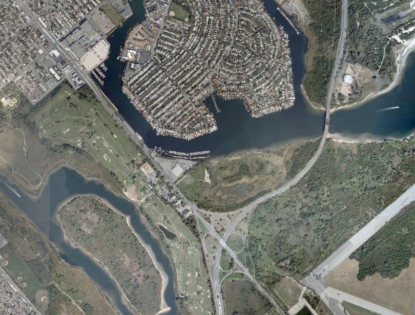
Management Summary

SHPO Project Review Number:       n/a

Involved Agencies:                New York City Environmental Development
                                  Corporation
                                  Office of the Deputy Mayor for Economic Development
                                  New York City Department of Small Business Services
                                  New York City Planning Commission
                                  New York City Department of Environmental Protection
                                  New York State Department of Environmental
                                  Conservation

Phase of Survey:                  Phase 1A Documentary Study

Location Information
       Location:                  New York City Tax Block 8591, Lots 100 (part), 125
                                  (part), and 175
       Minor Civil Division:      04701
       County:                    Kings

Survey Area
       Length:                    365.76 meters (1,200 feet)
       Width:                     53.34 to 228.6 meters (175 to 750 feet)
       Total Area Surveyed:       Approximately 11.75 acres

USGS 7.5 Minute Quadrangle Map:   Coney Island

Report Author:                    Elizabeth D. Meade, M.A., R.P.A.

Date of Report:                   October 2011 (Revised December 2011)

                                  i
Table of Contents

Chapter 1: Introduction and Methodology .............................................................................................. 1
       A. Project Overview and description .................................................................................................... 1
       B. Research Goals and Methodology.................................................................................................... 2
Chapter 2: Environmental and Physical Settings .................................................................................... 4
       A. Geology and Topography ................................................................................................................ 4
       B. Hydrology ........................................................................................................................................ 4
       C. Soils .................................................................................................................................................. 5
       D. Paleoenvironment ............................................................................................................................ 5
       E. Current Conditions ........................................................................................................................... 6
Chapter 3: Precontact Period .................................................................................................................... 7
       A. Precontact Context ........................................................................................................................... 8
       B. Previously Identified Native American Archaeological Sites .......................................................... 8
Chapter 4: The Historic Period ............................................................................................................... 10
       A. The History of the Project Site ....................................................................................................... 10
Chapter 5: Conclusions and Recommendations .................................................................................... 13
       A. Sensitivity Assessment................................................................................................................... 13
       B. Recommendations .......................................................................................................................... 13
References .................................................................................................................................................. 14

                                                                                ii
List of Figures
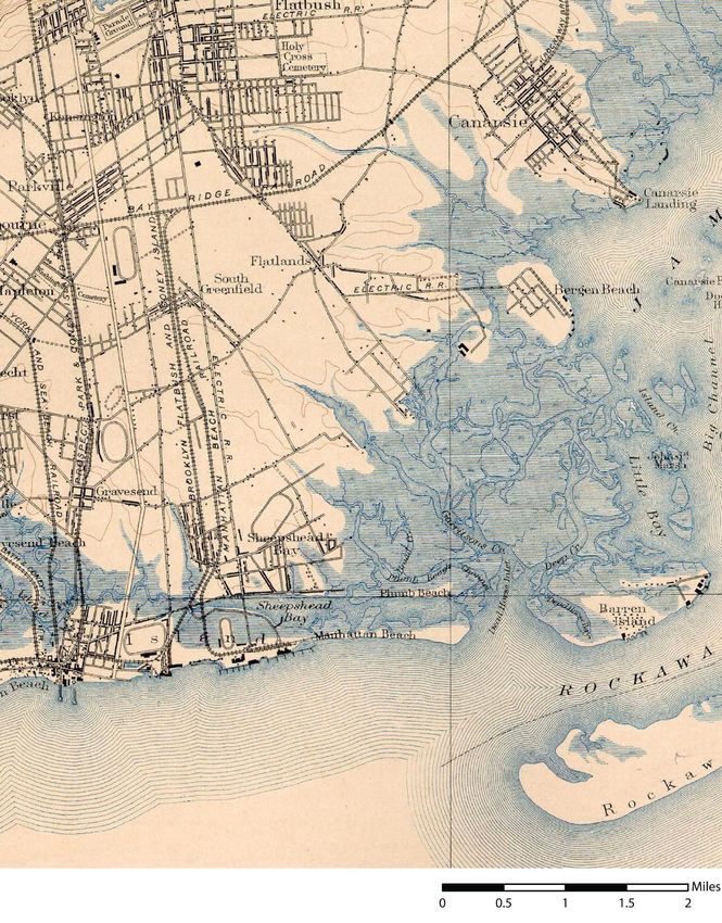
Figure 1: Project Location; United States Geological Survey (USGS) Maps, Coney Island Quadrangle.
Figure 2: Project site map showing camera angles for site photographs; Sanborn Insurance Map.
Figure 3: Proposed Site Plan.
Figure 4: Depth of Fill as Indicated by Soil Borings
Figure 5: 1898 USGS Map.
Figure 6: Aerial Photograph.
Figure 7: Nautical Chart, 1924.
Figure 8: Nautical Chart, 1954.
Figure 9: 1986 Sanborn Map.
List of Photographs
See Figure 2 for Camera Angles
Photograph 1: Looking northwest from Lot 100 at the existing Toys ‘R’ Us.
Photograph 2: Looking north from Lot 125 towards Lot 175, showing the structures associated with the
Sea Traveler’s Marina and the Mill Basin waterfront.
Photograph 3: The Sea Traveler’s Marina on Lot 175.
Photograph 4: The paved path at the northern side of the development parcel, looking west towards
Flatbush Avenue.
List of Tables
Table 1: Project Area Soils .......................................................................................................................... 5
Table 2: Previously Identified Precontact Archaeological Sites .................................................................. 8
Table 3: Previously Identified Historic Archaeological Sites .................................................................... 10
iii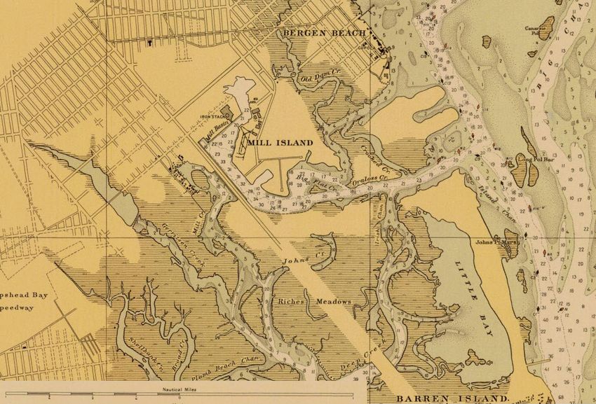
Chapter 1:                                                               Introduction and Methodology

A. PROJECT OVERVIEW AND DESCRIPTION
The Mayor’s Office of Economic Development is proposing the disposition and redevelopment of City-
owned land in the Marine Park neighborhood of Brooklyn, Kings County, New York (see Figure 1). The
proposed project site is located on the eastern side of Flatbush Avenue northeast of the interchange with
the Belt Parkway and about a half mile south of the intersection with Avenue U. The project is located on
Block 8591, Lots 100 (part), 125 (part), and 175, which combined make up an approximately 11.75-acre
parcel of land currently owned by the City of New York (see Figure 2). The disposition of the project site
and its subsequent redevelopment by privately-owned businesses would be consistent with the City’s
objectives to revitalize its underutilized properties for the purposes of providing economic and fiscal
benefits.
The project site is bordered to the north and south by vacant City land and to the east by the existing Sea
Traveler’s Marina—which leases the portion of the project site on which it is located from the City—and
the waters of Mill Basin. The project site is currently managed by the New York City Department of
Small Business Services (NYCDSBS). The proposed actions would include the disposition of the site
from NYCDSBS to the New York City Environmental Development Corporation (NYCEDC) and then
sold to private developers.
 An existing 1-story concrete structure currently occupied by Toys ‘R’ Us and an associated parking lot
are currently located on Lot 125. As part of the proposed actions, Toys ‘R’ Us Delaware Inc. would
purchase the land from the City. The existing facility would remain on the project site and the adjacent
parking lot would be expanded to cover a 26,800 square foot easement covering a portion of Lot 100.
Other improvements to this portion of the project site could include landscaping and minor site and utility
improvements and grading and paving of the expanded parking area.
The proposed Kristal Auto Mall development, which is proposed by the Bical Development Corporation,
would involve the purchase of the land from the City and the subsequent construction of a new 2-story
structure with an automobile showroom and sales and service space; an accessory parking lot; and a small
accessory structure on Lots 125 and 175. There would also be stormwater runoff, infrastructure
improvements, and landscaping involved with the construction of the proposed auto mall.
No changes are proposed along the waterfront and underwater portions of Lots 125 and 175 and the Sea
Travelers Marina would continue to lease the property from the City. Thus, the City would retain
ownership of all waterfront and underwater lands within the project site to maintain public waterfront
access. In addition, agreements would be made between the City and Bical Development Corporation to
allow for the construction of a 10-foot wide public walkway along City-owned waterfront land.
The proposed developments on the project site would be sponsored by the New York City Department of
Small Business Services (NYCDSBS) and two prospective land purchasers, Toys ‘R’ Us Delaware Inc.
and Bical Development Corporation (see Figure 3). A number of discretionary actions are necessary for
the completion of the proposed development projects, including changes to the City map; disposition of
the project site to the two prospective purchasers; waterfront zoning lot subdivision; and the rezoning the
project site. The proposed actions will also require permits and approvals from the Office of the Deputy
Mayor for Economic Development (ODMED), the New York State Department of Environmental
Conservation (DEC), the New York City Planning Commission (NYCCPC), and the New York City
Department of Environmental Protection (NYCDEP). Several of these actions are subject to review under
the City’s Uniform Land Use Review Procedure (ULURP), and City Environmental Quality Review

                                                1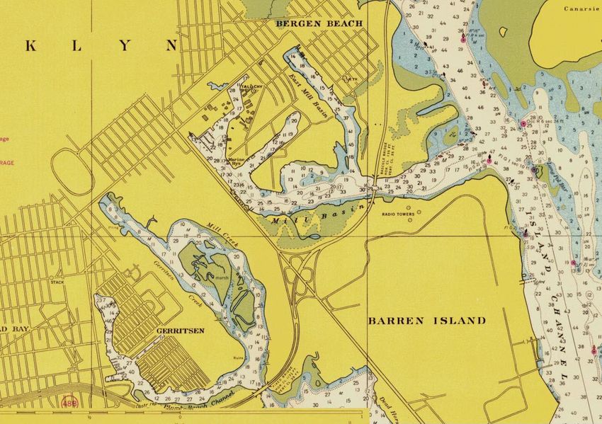
Mill Basin Projects—Phase 1A Archaeological Documentary Study

(CEQR), and the State Environmental Quality Review Act (SEQRA). ODMED is serving as the lead
agency for environmental review.
As part of the CEQR review process, consultation was initiated with the New York City Landmarks
Preservation Commission (LPC) to determine if the proposed project possessed archaeological
significance. In comments dated December 16, 2010, LPC determined that Block 8591, Lot 125 was not
potentially sensitive for archaeological resources, however, Lots 100 and 175 were determined to have
archaeological significance. LPC requested that a Phase 1A Archaeological Documentary Study be
prepared for those lots only.
B. RESEARCH GOALS AND METHODOLOGY
This Phase 1A Archaeological Documentary Study has four major goals: (1) to determine the likelihood
that the project site was occupied during the precontact (i.e. Native American) and/or historic periods; (2)
to determine the effect of subsequent development and landscape alteration on any potential
archaeological resources that may have been located at the project site; (3) to make a determination of the
project site’s potential archaeological sensitivity; and (4) to make recommendations for further
archaeological analysis, if necessary. The steps taken to fulfill these goals are explained in greater detail
below. The study has been designed to satisfy the requirements of LPC and it follows the guidelines of
the New York Archaeological Council (NYAC).
The first goal of this documentary study is to determine the likelihood that the project site was inhabited
during the precontact or historic periods and identify any activities that may have taken place on the
project site that would have resulted in the deposition of archaeological resources. In order to determine
the likelihood of the project site’s occupation during the precontact and historic periods, documentary
research was completed to establish a chronology of the project site’s development, landscape alteration,
and to identify any individuals who may have owned the land or worked and/or resided there and to
determine if buildings were present on the project site in the past. Data were gathered from various
published and unpublished primary and secondary resources, such as historic maps, topographical
analyses (both modern and historic), historic photographs, newspaper articles, local histories, previously
conducted archaeological surveys, and information from the files of LPC and the New York State Office
of Parks, Recreation, and Historic Preservation (OPRHP) and the New York State Museum (NYSM)
regarding previously identified archaeological sites within 1 mile of the project site. On-line textual
archives, such as Google Books and the Internet Archive Open Access Texts, were also accessed.
The second goal of this Phase 1A study is to determine the likelihood that archaeological resources could
have survived intact on the project site after development and landscape alteration (i.e. erosion, grading,
filling, etc). Historic maps documenting structures on the project location were analyzed and historic and
current topographical maps were compared to determine the extent to which the project site has been
disturbed. Potential disturbance associated with paving and utility installation was also considered.
After identifying the likelihood that archaeological resources were deposited on the project site and that
the likelihood that they could remain intact given subsequent development and landscape alteration, a
sensitivity determination was made for the project site for both precontact and historic period resources.
As described by NYAC in their Standards for Cultural Resource Investigations and the Curation of
Archaeological Collections in New York State (1994: 2):
“An estimate of the archaeological sensitivity of a given area provides the archaeologist with a tool with
which to design appropriate field procedures for the investigation of that area. These sensitivity
projections are generally based upon the following factors: statements of locational preferences or
tendencies for particular settlement systems, characteristics of the local environment which provide
essential or desirable resources (e.g. proximity to perennial water sources, well-drained soils, floral and

                                                  2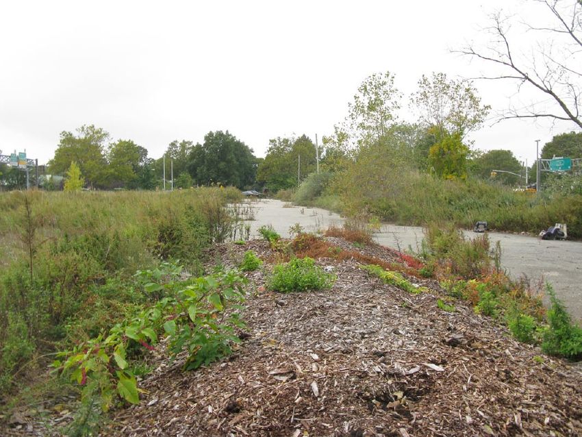
Chapter 1: Introduction and Methodology

faunal resources, raw materials, and/or trade and transportation routes), the density of known
archaeological and historical resources within the general area, and the extent of known disturbances
which can potentially affect the integrity of sites and the recovery of material from them.”
As stipulated by the NYAC standards, sensitivity assessments should be categorized as low, moderate, or
high to reflect “the likelihood that cultural resources are present within the project area” (NYAC 1994:
10). For the purposes of this study, those terms are defined as follows:
       • Low: Areas of low sensitivity are those where the original topography would suggest
       that Native American sites would not be present (i.e. locations at great distances from
       fresh and salt water resources), locations where no historic activity occurred before the
       installation of municipal water and sewer networks, or those locations determined to be
       sufficiently disturbed so that archaeological resources are not likely to remain intact.
       • Moderate: Areas with topographical features that would suggest Native American
       occupation, documented historic period activity, and with some disturbance, but not
       sufficient disturbance to eliminate the possibility that archaeological resources are intact
       on the project site.
       • High: Areas with topographical features that would suggest Native American
       occupation, documented historic period activity, and minimal or no documented
       disturbance.

                                                    3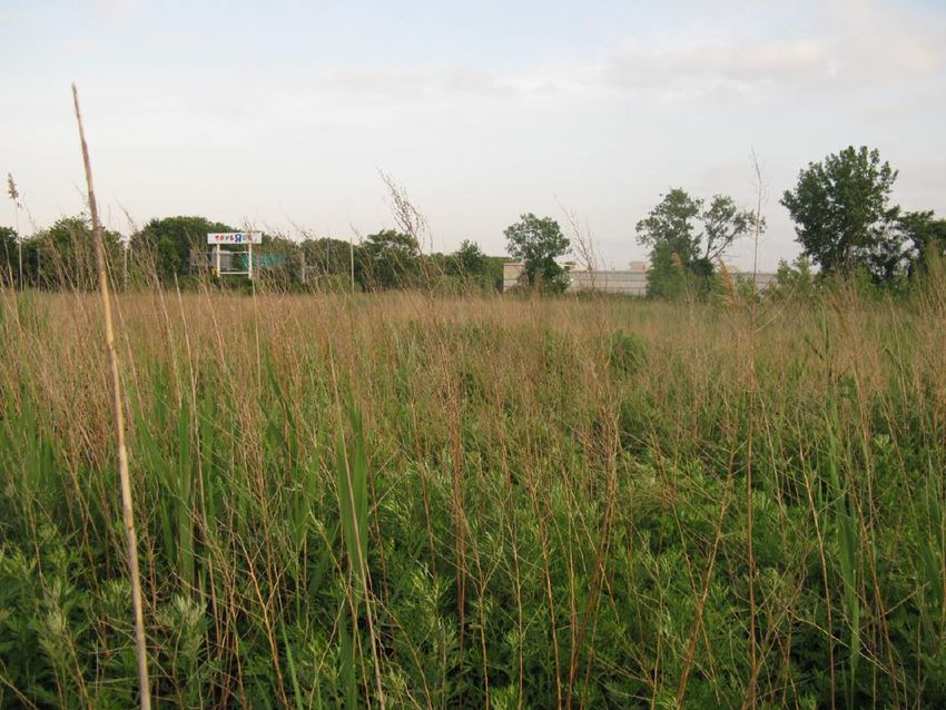
Chapter 2:                                                           Environmental and Physical Settings

A. GEOLOGY AND TOPOGRAPHY
The borough of Brooklyn is found within a geographic bedrock region known as the Atlantic Coastal
Plain Province. This has been described as “that portion of the former submerged continental shelf which
has been raised above the sea without apparent deformation” (Reeds 1925: 3). Soils on Long Island, on
which Kings County is located, are composed of glacial till or undifferentiated sediments such as sand
and clay. The Atlantic Coastal Plain is typified by “flat, low-lying” ground “that slopes very gently
toward the sea” (Isachsen, et al. 2000: 149).
The glacial till making up the upland portions of Kings County was deposited by the massive glaciers that
retreated from the area towards the end of the Pleistocene (1.6 million years before present [“BP”] to
approximately 10,000 years BP). There were four major glaciations that affected New York City,
culminating approximately 12,000 years ago with the end of the Wisconsin period. During the ice age, a
glacial moraine bisected Brooklyn, running in a northeast-southwest direction (Homberger 1994). The
deposition of glacial till in the wake of the retreating glaciers resulted in the creation of sand hills, known
as kames, across New York City, some of which rose to heights of one hundred feet. The Hempstead
Outwash Plain, on which the project site is situated, was formed at this time (Bernstein and Merwin
2009).
The surface topography of the area generally slopes down to the north, toward the Mill Basin Creek, a
tidal estuary north-adjacent to the project site. According to maps compiled by the U.S. Geological
Survey, the property lies at an elevation of between approximately 5 to 10 feet, based on the National
Geodetic Vertical Datum of 1929 (an approximation of mean sea level). Current site plans of the
development parcel show that the elevation of the proposed development parcel rises to heights of 12 to
16 feet above sea level, sloping gently down to sea level to the east. Elevations in the vicinity of Lot 175
rise to a height of 10 to 11 feet along Flatbush Road, again sloping down to the water. This suggests the
presence of many feet of fill throughout the majority of the project site.
A series of soil borings completed within Lot 100 in 2000 as part of a previous environmental assessment
of the site indicated that the fill level was at least 14 feet thick across most of the site (see Figure 4). In
addition, peat, which likely made up the original marshy islands that once occupied the site, was
identified in only a few of the 22 borings that were completed. This is possibly the result of landscape
modifications in the 20th century, when the area was transformed during the construction of the Belt
Parkway, during which both natural and artificial deposits were removed and replaced with clean, sandy
fill (Historical Perspectives, Inc. 2000). The peat levels were identified between approximately 27 and 31
feet below the ground surface (ibid).
B. HYDROLOGY
The project site is located in an area that was historically occupied by a series of tidal marsh islands at sea
level (see Figure 5). The marshes were punctuated by channels and streams of various sizes. The project
site is adjacent to the Four Sparrow Marsh, Mill Basin, and Jamaica Bay (see Figure 6). Portions of the
marshland were filled in the mid-20th century (described in greater detail below). Soil borings completed
by AKRF in 2007 as part of a Phase II Environmental Site Assessment indicate that groundwater on Lot
125 is located between 4.5 and 8 feet below grade (AKRF 2007).
The Four Sparrow Marsh, within Lot 100 to the south of the project site contains four wetlands as mapped
by the United States Fish and Wildlife Service (USFWS) National Wetland Inventory (NWI) tidal and

                                                  4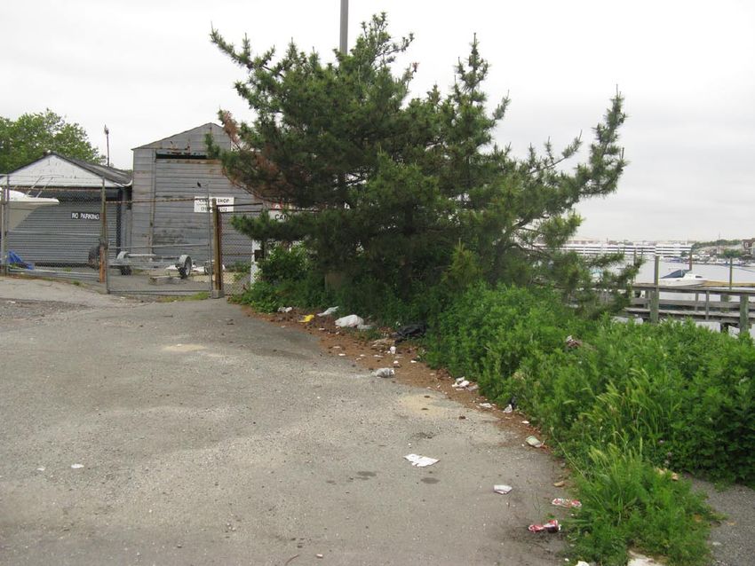
Chapter 2: Environmental and Physical Settings

freshwater wetland maps. The majority of the area is classified as intertidal estuarine wetlands that are
irregularly flooded. In addition, the marsh contains an unnamed tidal creek and tidal open water area.
C. SOILS
The New York City Soil Reconnaissance Survey published by the National Resource Conservation Service
(2005) indicates that the soils in the vicinity of the project site belong to two soil complexes; soils across
the majority of the project site (near Lots 125 and 175) are known as the “Pavement & Buildings—Wet
Substratum” complex, while Lot 100 is typified by the “Inwood-Laguardia-Ebbets Complex” (New York
City Soil Survey Staff 2005).
The soils in Lots 125 and 175, the Pavement & Buildings—Wet Substratum complex, are found in highly
urbanized, nearly level to gently sloping areas (0 to 5 percent slopes) that are more than 80 percent
covered with impervious pavement and/or buildings (New York City Soil Survey Staff 2005). These areas
are typically in areas of filled swamp, tidal marsh, or water. The soils of Lot 100, the Inwood-Laguardia-
Ebbets Complex, are also typically found in nearly level to gently sloping areas (0 to 8 percent slopes),
however, in areas “that have been filled with a mixture of natural soil materials and construction debris; a
mixture of anthropogenic soils which vary in coarse fragment content” (ibid: 12). Summaries of the
components of this soil complex are provided in Table 1, below. In addition, historic accounts suggest
that the salt meadows were covered with “Galveston Clay,” which was described as “black muck and a
matted mass of eel grass roots, with bluish or leaf-colored silty clay beginning at a depth of approximately
two feet” (Pickman 1987: 3).
Soil borings completed by AKRF in 2007 as part of a Phase 2 Environmental Site Assessment suggested
that the soils on Lots 125, the only lot included in the soil boring program at that time, are primarily
composed of sand. Concrete and timber fragments were observed in the borings, suggesting that the soil
at the site is urban fill. The borings identified 5 to 10 feet of fill throughout Lot 125. All borings were
terminated at 10 feet below grade, so the maximum depth of fill in the vicinity is not known. Groundwater
was encountered between 4.5 and 8 feet below ground surface. As mentioned previously, additional
borings completed in 2000 identified 13 to 16 feet of fill in the northern portion of Lot 100 (Historical
Perspectives, Inc. 2000).
                                                                                                                     Table 1
                                                                                                           Project Area Soils
               Soil Horizon Depth                                Texture,
 Series Name       (in inches)            Color                 Inclusions         Slope (%)    Drainage         Landform
                    A: 0 to 6         Yellowish Brown
                   Bw: 6 to 12           (10YR5/4)             Fill materials;                                     Modified
   Inwood                                                      gravelly sandy           0-3    Well-drained   landscapes near
                   C1: 12 to 16       Yellowish Brown               loam                                        urban centers
                   C2: 16 to 65          (10YR5/6)
                    A: 0 to 8                                  Fill materials;                                     Modified
  Laguardia        Bw: 8 to 26       Brown (10YR4/3)           gravelly sandy       0 to 10    Well-drained   landscapes near
                   C: 26 to 79                                      loam                                        urban centers
   Ebbets                                                   Description not available
Sources:    Soil Survey Staff, Natural Resources Conservation Service, United States Department of Agriculture.
            Official Soil Series Descriptions. Available online at
            http://soils.usda.gov/technical/classification/osd/index.html. Accessed February 2011.

D. PALEOENVIRONMENT
Due to the extended glacial period that left the Northeast blanketed in thick ice sheets for thousands of
years, the area was not inhabited by humans until approximately 11,000 years ago. As temperatures

                                                        5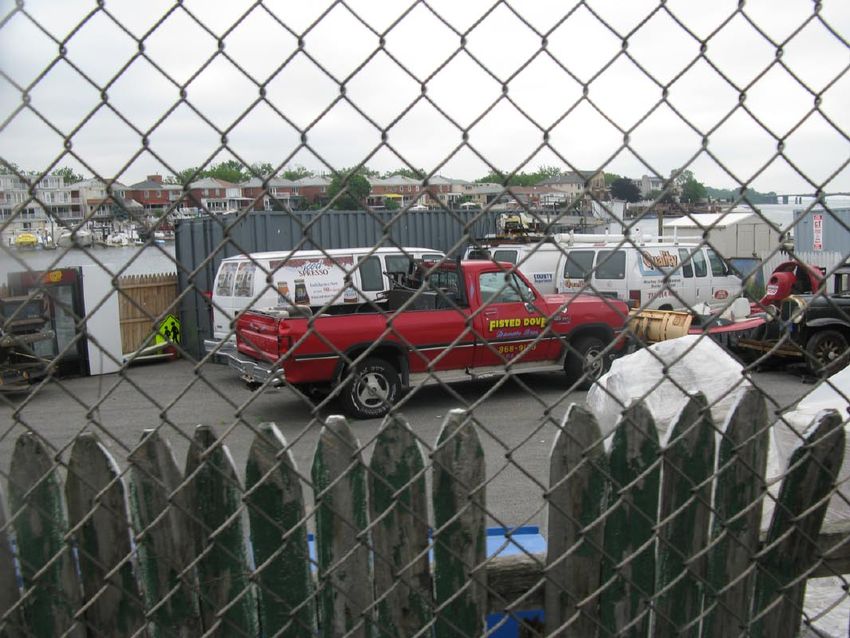
Mill Basin Projects—Phase 1A Archaeological Documentary Study

increased, a variety of flora and fauna spread through the region. At this time, large open forests of
spruce, fir, pine, and other tree species expanded across the Northeast, interspersed with open meadows
and marshland. A wide variety of animal life could also be found, including large mammals such as
mammoth, mastodon, caribou, musk ox, moose, as well as smaller mammals such as fox, beaver, hare,
and many kinds of marine animals.
Climate changes continued to re-shape the environment of the Northeast as time progressed. As the
climate grew increasingly warmer, jack pine, fir, spruce, and birch trees were replaced with hardwood
forests of red and white pine, oak, and beech (Ritchie 1980). Furthermore, a decrease in glacial runoff
resulted in the creation of small bodies of water such as lakes as well as, later on, low-lying marshes and
swampy areas. By the time of the Early Archaic period, beginning approximately 10,000 BP, there was
“considerable environmental diversity, with a mosaic of wetlands, oak stands, and a variety of other plant
resources…[making it]…an attractive and hospitable quarter for both human and animal populations”
(Cantwell and Wall 2001: 53). Warmer temperatures forced the herds of large mammals to travel north
before eventually dying out. The new surroundings attracted other animals such as rabbit, turkey,
waterfowl, bear, turtles, and white-tailed deer. The expanded water courses became home to a variety of
marine life, including many varieties of fish, clams, oysters, scallops, seals, and porpoises, among others
(ibid).
E. CURRENT CONDITIONS
The project site is currently divided into three tax lots, two of which, Lots 100 (part) and 175, are the
subject of this Phase 1A Archaeological Documentary Study. Lot 175, the site of the proposed Kristal
Auto Mall site, is currently a paved lot used for parking and boat storage and sales associated with the
adjacent Sea Traveler’s Marina. Three small adjacent structures are present at the southern end of the lot.
Lot 125, which is not analyzed in this study, contains a paved lot and a 1-story commercial structure
currently occupied by a Toys ‘R’ Us. The Sea Traveler’s Marina occupies the area to the east of the
building on this lot. In 1996, twelve 550-gallon underground gasoline storage tanks were removed from
the western portion of the marina and were replaced with two 4,000-gallon tanks (AKRF 2004). Vent
pipes likely associated with these tanks were visible near the marina’s shed (presumably on Lot 175)
during a 2004 Environmental site assessment completed by AKRF (ibid).
Finally, Lot 100 is mostly occupied by the Four Sparrow Marsh, a 67-acre wetland preserve. The majority
of this lot is covered with tidal wetland. While the landscape has been transformed from that seen prior to
the 20th century, the marshland has been largely isolated from the adjacent developed areas and as a
result “has been allowed to remain in a fairly natural condition” and is home to a wide variety of flora and
fauna, including hundreds of species of migratory birds (New York City Department of Parks n.d). The
wetlands have natural intertidal and high marsh shoreline edges. The southern edges of the marsh along
Shore Parkway are upland and planted with trees. The portion of Lot 100 adjacent to Lot 125, including
the portion that is situated within the project site, was filled in the late-20th century and is the site of the
proposed development parcel (sees Figures 2 and 3). This area is covered with grass and vegetation. The
Mill Basin shoreline of Lot 100 is lined with rip-rap and a stormwater runoff outfall is located in the area.
The filled portion of the lot contains a narrow asphalt-paved path that connects it to Flatbush Avenue, and
a dirt nature path crosses through the area.

                                                   6
Chapter 3: Precontact Period
A. PRECONTACT CONTEXT
Archaeologists have divided the time between the arrival of the first humans in northeastern North
America and the arrival of Europeans more than 10,000 years later into three periods: Paleo-Indian
(11,000-10,000 BP), Archaic (10,000-2,700 BP), and Woodland (2,700 BP–AD 1500). These divisions
are based on certain changes in environmental conditions, technological advancements, and cultural
adaptations, which are observable in the archaeological record.
As mentioned in Chapter 2, human populations did not inhabit the Northeast until the glaciers retreated
some 11,000 years ago. These new occupants included Native American populations referred to by
archaeologists as Paleo-Indians, the forbearers of the Delaware—also called the Lenape Indians—who
would inhabit the land in later years. Archaeological evidence suggests that the Paleo-Indians were likely
highly mobile hunters and gatherers who utilized a distinct style of lithic technology, typified by fluted
points. They appear to have lived in small groups of fewer than 50 individuals (Dincauze 2000) and did
not maintain permanent campsites. In addition, most of the Paleo-Indian sites that have been investigated
were located near water sources. Because of the close proximity of Paleo-Indian sites to the coastline, few
have been preserved in the New York City area.
The Archaic period has been sub-divided into three chronological segments, based on trends identified in
the archaeological record which reflect not only the ecological transformations that occurred during this
period, but the cultural changes as well. These have been termed the Early Archaic (10,000–8,000 BP),
the Middle Archaic (8,000–6,000 BP) and the Late Archaic (6,000–2,700 BP) (Cantwell and Wall 2001).
The Late Archaic is sometimes further divided to include the Terminal Archaic (3,000-2,700 BP). The
abundance of food resources which arose during this period allowed the Archaic Native Americans to
occupy individual sites on a permanent or semi-permanent basis, unlike their nomadic Paleo-Indian
predecessors. Fishing technology was developed during the Middle Archaic in response to an increasing
dependence on the area’s marine resources. Tools continued to be crafted in part from foreign lithic
materials, indicating that there was consistent trade among Native American groups from various regions
in North America throughout the Archaic period. Few Early and Middle Archaic archaeological sites have
been identified in New York City, although numerous Late Archaic sites have been identified in the area.
The Woodland period represents a cultural revolution of sorts for the Northeast. During this time, Native
Americans began to alter their way of life, focusing on a settled, agricultural lifestyle rather than one of
nomadic hunting and gathering. Social rituals become visible in the archaeological record from this time
period. Composite tools, bows and arrows, domesticated dogs, and elaborately decorated pottery were
introduced to Native American culture at this time and burial sites grew increasingly complex. Woodland-
era sites across North America indicate that there was an overall shift toward full-time agriculture and
permanently settled villages. Archaic sites in New York City, however, suggest that the Native Americans
there continued to hunt and forage on a part-time basis. This was most likely due to the incredibly diverse
environmental niches that could be found across the region throughout the Woodland period (Cantwell
and Wall 2001, Grumet 1995).
The Woodland period ended with the arrival of the first Europeans in the early 1500s. After the Dutch
settled the colony of New Amsterdam in the early 17th century, they quickly began to purchase large
areas of land from the Native Americans. By the mid-17th century, the Native Americans had sold nearly
all of their land in Brooklyn to the Dutch (Black 2001).
7Mill Basin Projects—Phase 1A Archaeological Documentary Study
B. PREVIOUSLY IDENTIFIED NATIVE AMERICAN ARCHAEOLOGICAL SITES
Site file searches at OPRHP and NYSM indicate that 5 precontact archaeological sites have been identified
within approximately one mile of the project site. Most of these sites were discovered in the early 20th
century by avocational archaeologists and were reported by authors such as Arthur C. Parker (1922),
Reginald P. Bolton (1922), and Alanson Skinner (1920). Unfortunately, few of these sites were well-
documented and little is known about the precontact sites’ exact locations, extent, or artifact collections. In
fact, many of these reported sites seem to overlap and several have been grouped together in Table 2,
below. The majority of the sites represented precontact villages, some with burials and shell middens.
All of the previously identified sites in the area were located on upland areas near the border of the marshy
islands of the Jamaica Bay. The most well-documented and largest-known archaeological site in Brooklyn is
the Ryder’s Pond site, located on the western side of Gerritsen’s Creek, approximately one mile west of the
project site (Cantwell and Wall 2001). This precontact village was also known as Shanscomacocke, meaning
“wholly enclosed place” or “landing place” (Grumet 1981). The settlement was in the upland area which
rose “quite abruptly above the high-tide level in the pond” (Bolton 1922: 160). In 1979, H. Arthur Bankoff
and Frederick Winters of Brooklyn College conducted an excavation in the vicinity of Ryder’s Pond in an
area where landfilling was proposed (Bankoff, et al. 1997). Intact Native American deposits dating to the
Late Woodland were encountered, including shell middens, pottery, and beads (ibid).
Table 2
Previously Identified Precontact Archaeological Sites
Approximate
Site Name Site Number Distance from Time Period Site Type and Information Reference(s)
APE
1.33 miles Late Precontact- Native American village on Barren
Equendito SHPO: 04701.000114
(7,000 feet) early Historic Island
Native American village and shell
0.85 miles Early historic,
middens; The area has since been
Winnipague SHPO: 04701.000115 possibly Bolton (1934)
(4,500 feet) disturbed through development and
Canarsee
landfilling.
0.71 miles
ACP Kings-4 NYSM: 3608 Woodland Burials, shell middens, and pottery Parker (1922)
(3,750 feet)
0.9 miles
ACP Kings-3B NYSM: 7391 Unknown Shell middens at Bergen Island Parker (1922)
(4,750 feet)
Canarsee village on the western
bank of Ryder’s Pond/Gerritsen’s
Creek, burials were located on
higher ground in the vicinity of
Ryder’s Pond/ NYSM: 7459 1 mile Late Archaic- Avenue U. Native American pottery
Bolton (1922)
Shanscomacocke SHPO: 04701.000112 (5,280 feet) Contact recovered; excavated extensively
in the late-19th and early-20th
centuries. The area has since been
disturbed through development and
landfilling.
Source: Site files of OPRHP.
The area surrounding the project site was occupied by the Canarsee Indians, a branch of the Munsee
(Cantwell and Wall 2001). Their “principal station” was the Canarsee site, more than one mile to the
northeast of the project site (ibid). Other major Canarsee stations were at Winnipague, later known as
Bergen Beach, to the northeast of the project site, and Equendito, later known as Barren Island, to the south.
Both of these sites were identified within areas of fast land surrounded by marsh. The term Equendito has
been translated as “land broken up” and may refer to the entire chain of marshy islands in the vicinity of the
project site, although the precontact village was located on the dry land making up Barren Island (Grumet
8Chapter 3: Precontact Period
1981). The presence of significant quantities of shell in this area suggests that it was likely a center for
wampum manufacture (Black 2001).
To date, no Native American sites have been identified within the former marshy islands of Jamaica Bay.
The sites that have been located were near upland areas that would not have been affected by the tidal
waters but were close enough to the marsh to exploit the tremendous resources that it provided. Marine life
and wild game were abundant in this area during the precontact period, making the shores of Jamaica Bay
attractive habitation sites to the Canarsee. As mentioned above, evidence of Native American activity has
been documented in some of the small areas of dry land that punctuated the marshes, such as Mill and
Barren Islands. However, the border between marshes and dry land has not been consistent and sea levels
have changed dramatically since the population of the northeastern United States began more than 10,000
years ago. It has been estimated that the marshes of Jamaica Bay, which were formed as a result of melting
glacial ice, were created approximately 2,500 to 3,800 years ago (Pickman 1987). Therefore, it is possible
that archaeological deposits associated with the earliest occupation of the Jamaica Bay area may have been
inundated by tidal marshes after their occupation by Native Americans, potentially preserving artifacts
beneath protective layers of peat and clay deposits. However, dredging, channeling, and landfilling have
drastically altered the landscape of this area.
9Chapter 4: The Historic Period
A. THE HISTORY OF THE PROJECT SITE
The project site was occupied by islands of salt marsh making up “Flatlands Bay” until the 20th century.
Maps dating to the 19th and early 20th centuries, such as the 1898 USGS map included as Figure 5,
depict the project site as sea-level, tidal salt marsh surrounded by channels and inlets, including a
precursor to Mill Basin to the northeast. Several marsh islands of various sizes were formerly located in
the project site. The creeks and islands were named in the 19th century by local fishermen (Black 2001)
and the marshes located near the project site were bounded to the west by Mill Creek, John’s Creek to the
south (this may be a precursor to the stream that runs through the center of the Four Sparrow Marsh), Flat
Creek to the northeast, and Irish Creek and Crooked or Orabus Creek to the east. The islands making up
the project site were not always given names on historic maps, unlike the larger Mill Island to the
northeast and Riches Meadow to the south, although some maps identify the large marsh on the western
side of the project site as Hemlock Meadows and the easternmost marsh as Orabus Meadows.
Settlement in this part of Brooklyn occurred slowly during the historic period, however some of the oldest
homes established in the area in the 17th century were on the waterfront near Jamaica Bay. In addition,
numerous mills were established along the many creeks and streams that ran out into the marshes of the
Jamaica Bay. Five historic period archaeological sites have been reported within 1.5 miles of the project
site, including the Gerritsen Home to the west in the vicinity of the Ryder’s Pond precontact
archaeological site. These sites are summarized in Table 3, below.
Table 3
Previously Identified Historic Archaeological Sites
Approximate
Site Name Site Number Distance from Time Period Site Type and Information
APE
1.14miles 18th-20th
Bergen House SHPO: 04701.000119 Historic home
(6,000 feet) century
Schenck-Crooke 0.9 miles 17th-20th
SHPO: 04701.000120 Historic home and mill
House and Mill (4,750 feet) century
Gerritsen Home 0.85 miles 17th-20th
SHPO: 04701.000122 Historic home and mill
and Mill (4,500 feet) century
1.42 miles Glue manufacturing industrial
Rendering Plant SHPO: 04701.000124 19th century
(7,500 feet) complex on Dead Horse Bay
0.66 miles Late-19th
Vorhees Site SHPO: 04701.000126 Historic home
(3,500 feet) century
Source: Site files of OPRHP.
In the immediate vicinity of the project site, one of the first major improvement projects was the filling in
of Mill Island and the creation of Mill Basin adjacent to the project site. At the end of the 19th century
and into the first decades of the 20th, the Department of Docks maintained control of Jamaica Bay and
encouraged industrial development in the area as well as the increased occupation of the area by
“fishermen, boaters, and summer cottagers” (Black 2001: 37). In anticipation of the industrialization of
the area, marshes were dredged and filled and Flatbush Avenue was extended as far south as Barren
Island, now the location of Floyd Bennett Field. Early industries on Mill Island, which was accessed via
Gerritsen’s and Mill Creeks, included a lead company and smelting works (ibid).
Mill Basin was constructed in 1915 in order to restore water access to Mill Island after Flatbush Avenue
was constructed across Rockaway Inlet (Black 2001). In order to create the artificial channel, its route
10Chapter 4: Historic Period
was dredged to a depth of 18 feet below mean low water (New York Times 1917). The construction of
Flatbush Avenue took place between 1913 and 1923 and required landfilling and bulkheading to construct
a roadway through the marshlands (Black 2001). Industries moved into the area, although significant
industrial development did not occur and instead, the area became a waterfront vacation destination in the
early 20th century (ibid).
Landfilling and landscape alterations in the vicinity of the project site began in the early 20th century and
United States Coastal Charts show that the project site began to take on an appearance similar to that seen
today by 1924 (see Figure 7). An aerial photograph of New York City made available on the City’s
“NYCityMap”1 website depicts the beginnings of this filling process. The photograph depicts significant
filling along the line of Flatbush Avenue and through a large portion of the current Four Sparrow Marsh,
although other areas of the project site, mostly in the vicinity of Lots 125 and 175, remained inundated by
marsh.
The construction of Floyd Bennett Field, the municipal airport located to the south of the project site, was
proposed in the late 1920s (New York Times 1927). Now part of the Floyd Bennett Field Historic District,
the Field was the first municipal airport in New York City and was constructed between 1928 and 1931
by the City Department of Docks. The airport was designed to attract air traffic to the New York City area
from Newark Airport, where most New York-bound flights landed, and in 1933 the Field was the second
busiest airport in the country. Floyd Bennett Field was closed to commercial use and conveyed to the U.S.
Navy in 1941, following the opening of Idlewild Airport, now John F. Kennedy International Airport, in
1938. The New York Times contains several accounts of accidents involving small planes in the vicinity of
the airfield, including one in 1932 when Captain Yoshinori Nagoya, a Japanese pilot, crash landed “just
over the marshy southern border of Mill Creek,” possibly in the vicinity of the project site, where his
plane exploded (New York Times 1932).
By 1930, Sanborn maps depict the area as largely undeveloped. A large crescent-shaped stream, both ends
of which connected to the Mill Basin, was present within the project site. That map depicts two small
structures just north of Lot 175. By the publication of the 1951 Sanborn map, the area was depicted as
entirely filled in although still undeveloped. By that time, Shore Parkway, originally known as
Circumferential Parkway, was constructed, forming the southern boundary of the project site. The road is
part of the Belt Parkway system that was officially opened in 1940 (New York Times 1940). The bridge
crossing Mill Basin near the eastern side of the project site was constructed in 1939 (New York Times
1939). At that time, scattered throughout the marshes of Jamaica Bay were “disreputable shanties,
houseboats, and fishing smacks” (ibid: 1).
A coastal chart from 1954 (see Figure 8) depicts the project site as partially filled, but still largely
marshy. An aerial photograph from 1951 available on the above-referenced NYCityMap website depicts
additional filling within the project site, much of which appears to be connected to the construction of
Shore Parkway to the south. Land in the vicinity of Lot 175 was filled out and piers were constructed out
into the water. Lot 125 appeared to have been largely marshy, although the proposed development parcel
within Lot 100 appears to have been filled in to a greater extent and a small path or road ran along its
western side, adjacent to Flatbush Avenue.
The first developments on the project site are depicted on a Sanborn map from 1968. That map identifies
the current Four Sparrow Marsh area, including portions of Lots 100 and 125, as a “golf driving range.”
This may actually represent a later update of the map, as the New York Times suggests that the Flatbush
Avenue Golf Driving Range leased the project site from the City circa 1972 and began “illegally placing
landfill on 30 acres of undeveloped property and wetlands” to build the driving range (Surfaro 1975). As
1
http://gis.nyc.gov/doitt/nycitymap/
11Mill Basin Projects—Phase 1A Archaeological Documentary Study
a result of the poor quality of fill materials used—which allegedly included “old mattresses and parts of
automobiles”— there was significant community backlash and in 1975 the driving range was ordered to
vacate the property immediately (ibid). Despite this, the site is labeled a driving range on Sanborn maps
dating to 1979, 1986 (see Figure 9), 1992, and 1996.
The 1968 Sanborn map also depicts a filling station to the north in the vicinity of Lot 125, however the
map may have been in error as aerial photos suggest that the filling station was further north (AKRF
2004). Sanborn maps from 1979 and 1986 (see Figure 9) continue to depict these developments, as well a
1-story commercial structure within Lot 125 lining the eastern side of Flatbush Avenue, which subsequent
maps identify as an office supply store (Historical Perspectives, Inc. 2000). This structure continues to
appear on current USGS maps (see Figure 1).
The maps also show that boats were being sold in Lot 125 and possibly in Lot 175 as well. The area was
identified as the Four Sparrow Marsh by 1987, when The New York Times mentioned that the site at that
time measured 85-acres. Of that land, 14 acres of the preserve were proposed as the location of a new
retail center because unlike the rest of the area, they were composed of landfill and were therefore
ecologically worthless (Waite 1987). The name was coined by naturalists in honor of four sparrow species
living in the marshes that “require undisturbed marshland for nesting” (New York City Department of
Parks n.d.).
In the late 1970s, a larger retail center had been proposed and a retailer leased the property for 99 years,
although nothing had been constructed (Waite 1987). By 1992, Sanborn maps show that the structure on
Lot 125 had been demolished and the existing Toys ‘R’ Us, constructed in 1991, is shown. Eight above-
ground fuel storage tanks were removed from the lot around that time (AKRF 2004). A 1996 aerial
photograph available at the NYCityMap website depicts the existing asphalt path at the northern end of
the proposed development parcel and depicts debris piles and irregular topography on the remainder of
the parcel. A similar aerial photograph taken 10 years later depicts the same area as flat and covered with
grass.
The later aerial also depicts greater inundation, possibly the result of marsh restorations that occurred in
the late 1990s and early 2000s. In 1997, funds generated by the Exxon Corporation’s lawsuit settlement
after the Exxon Valdez disaster were used to repair and maintain many wetlands in New York City,
including the Four Sparrow Marsh (Martin 1997). Later, in 2001, additional developments were proposed
for the area. Around that time, a group called “Friends of Marine Park” planted “a couple hundred” trees
in the area (Reeves 2001). A 3-acre section of the salt marsh was restored in the spring of 2004 by the
New York City Parks Department to “restore tidal flow to previously filled areas” (New York City
Department of Parks n.d.).
12Chapter 5: Conclusions and Recommendations
A. SENSITIVITY ASSESSMENT
As part of the background research for this Phase 1A Archaeological Documentary Study, various
primary and secondary resources were analyzed, including historic maps and atlases, historic photographs
and lithographs, newspaper articles, and local histories. The information provided by these sources was
analyzed to reach the following conclusions.
DISTURBANCE ASSESSMENT
The peripheries of the project site would have experienced some disturbance as a result of dredging
associated with the early-20th century industrial development of the area. The majority of the site is
covered with 20th century landfill. All developments dating to the historic period, including road and
building construction and associated infrastructure improvements (septic systems, water and sewer
connections, gasoline tanks, etc) would likely have impacted fill levels only.
PRECONTACT SENSITIVITY ASSESSMENT
The precontact sensitivity of project sites in New York City is generally evaluated by a site’s proximity to
level slopes (less than 12 to 15 percent), water courses, well-drained soils, and previously identified
precontact archaeological sites (NYAC 1994). In the vicinity of the project site, the upland areas near the
border of the marshy islands that covered the project site until the early-20th century would have been
ideal locations for Native American occupation sites because of the wide variety of exploitable resources
provided by the marshes. The marshes were likely formed approximately 2,500 to 3,800 years ago and
prior to that, sea levels were lower and the project site may have been habitable dry land (Pickman 1987).
Therefore, Paleo-Indian and Archaic archaeological sites may have been submerged by the rising sea levels
and may therefore be protected by layers of peat, clay, and fill.
The project site is considered to have moderate sensitivity for archaeological resources below the depth of
the historic fill, which is estimated to extend to approximately 5 to 20 feet below ground surface. Soil
borings indicate that the fill layer is thicker towards the south. In addition, it is likely that fill deposits
were removed and replaced with clean sandy fill during the construction of the Belt Parkway (Historical
Perspectives, Inc. 2000).
HISTORIC SENSITIVITY ASSESSMENT
The project site was not filled and developed until the early 20th century and there is no indication that it
was ever used for residential purposes. Therefore, the project site is determined to have no sensitivity for
archaeological resources dating to the historic period.
B. RECOMMENDATIONS
The project site has moderate sensitivity for precontact archaeological resources at depths below the
historic fill, approximately 5 to 20 feet below ground surface. Once the project plans are finalized, Phase
1B testing is recommended in any areas where excavation is expected to extend below the depth of fill as
exhibited on Figure 4. The Phase 1B testing could include geoprobes and additional soil borings to
investigate the subsurface conditions. As the depth of fill across the project site varies, project plans
should be reviewed by an archaeologist to ensure that no archaeological resources would be impacted by
the construction of the proposed project.
13References
AKRF
2004 Kristal Auto Mall; Brooklyn, NY: Phase I Environmental Site Assessment. Prepared for: Bical
Development Corp, Brooklyn, NY.
2007 2875 Flatbush Avenue; Brooklyn, NY: Subsurface (Phase II) Investigation. Prepared for: Bical
Development Corp, Brooklyn, NY.
Bankoff, H. Arthur, Chris Ricciardi, and Alyssa Loorya
1998 Gerritsen’s Creek: 1997 Archaeological Excavations. Prepared for: The Historic House Trust
Division of the New York City Department of Parks and Recreation.
Bernstein, David and Daria Merwin
2009 A Stage 1A Archaeological Survey for the National Grid Brooklyn-Queens Interconnector;
Boroughs of Brooklyn and Queens, New York City; Kings and Queens County, New York.
Prepared by the Institute for Long Island Archaeology, Department of Anthropology, State
University of New York at Stony Brook.
Bolton, Reginald Pelham
1922 “Indian Paths in the Great Metropolis.” In Indian Notes and Monographs. Miscellaneous #22.
New York: Museum of the American Indian, Heye foundation.
1934 Indian life of long ago in the city of New York. New York: J. Graham.
1975 New York City in Indian Possession. Museum of the American Indian, Heye Foundation, New
York.
Black, Frederick R.
2001 Jamaica Bay: A History; Gateway National Recreation Area, New York, New Jersey. Prepared for
the National Park Service.
Cantwell, Anne-Marie and Diana diZerega Wall
2001 Unearthing Gotham: The Archaeology of New York City. New Haven: Yale University Press.
City of New York
2011 NYCITYMAP. Accessed February 2011 at:
http://gis.nyc.gov/doitt/nycitymap/
Dincauze, Dena F.
2000 “The Earliest Americans: The Northeast.” Common Ground: Archaeology and Ethnography in
Public Interest. Washington, D.C.: National Park Service.
Grumet, Robert S.
1981 Native American Place Names in New York City. New York: Museum of the City of New York.
1995 Historic Contact. Norman, OK: University of Oklahoma Press.
Homberger, Eric
1994 The Historical Atlas of New York City: A Visual Celebration of New York City’s History. 2005
reprint. New York: An Owl Book, Henry Holt and Company.
Historical Perspectives, Inc.
2000 Memorandum: Preliminary Assessment/Disturbance Record: Mill Basin Promendae, Mill Basin,
Brooklyn, NY, Block 8591, Lots 100 and 125. Prepared for Allee, King, Rosen, and Fleming, Inc.;
New York, NY.
14References
Isachsen, Y.W., E. Landing, J.M. Lauber, L.V. Rickard, W.B.Rogers, editors.
2000 Geology of New York: A Simplified Account. Second Edition. New York: New York State
Museum Educational Leaflet 28.
Martin, Douglas
1997 “Exxon Valdez Money to Aid City Wetlands.” The New York Times. September 11, 1997: page
B3.
New York Archaeological Council
1994 Standards for Cultural Resource Investigations and the Curation of Archaeological Collections in
New York State. The New York Archaeological Council.
New York City Department of Parks
n.d. “Four Sparrow Marsh Preserve.” Accessed February 24, 2011 at:
http://www.nycgovparks.org/sub_about/parks_divisions/nrg/forever_wild/site.php?FWID=21
New York City Soil Survey Staff
2005 New York City Reconnaissance Soil Survey. United States Department of Agriculture, Natural
Resources Conservation Service, Staten Island, New York.
New York Times
1917 “Jamaica Bay Improvement.” April 15, 1917: page XX4.
1927 “Site for Brooklyn Airport.” September 21, 1927: page 17.
1932 “Japanese Aviator Dies in Crash Here.” March 30, 1932: page 5.
1939 “Brooklyn Span Approved.” April 19, 1939: page 46.
1940 “City Extends Highway System.” June 23, 1940: page XX1.
Parker, Arthur C.
1922 The Archaeological History of New York. Albany: The University of the State of New York.
Pickman, Arnold
1987 Assessment of Archaeological Resources in the Proposed Mill Basin Waterfront Special District;
Brooklyn, NY: Background Study. Prepared for: Tippetts, Abbett, McCarthy, and Stratton.
Reeds, Chester A.
1925 The Geology of New York City and Vicinity. New York: The American Museum of Natural
History Guide Leaflet Series No. 56.
Reeves, Hope
2001 “They Dislike a Tract’s Weeds, Bur Oppose Shops Even More.” The New York Times. February 4,
2001: page CY9.
Ritchie, William A.
1980 The Archaeology of New York State: Revised Edition. Harrison, New York: Harbor Hill Books.
Sanborn Map Company
1930 Insurance Maps of the City of New York. New York: Sanborn Map Co.
1951 Insurance Maps of the City of New York. New York: Sanborn Map Co.
1968 Insurance Maps of the City of New York. New York: Sanborn Map Co.
1979 Insurance Maps of the City of New York. New York: Sanborn Map Co.
1986 Insurance Maps of the City of New York. New York: Sanborn Map Co.
2006 Insurance Maps of the City of New York. New York: Sanborn Map Co.
15Mill Basin Projects—Phase 1A Archaeological Documentary Study
Schuberth, Christopher J.
1968 The Geology of New York City and Environs. Garden City, New York: The American Museum of
Natural History, the Natural History Press.
Skinner, Alanson
1920 “Archeological Investigations of Manhattan Island, New York City.” Indian Notes and
Monographs II (6). New York: Museum of the American Indian Heye Foundation.
Surfaro, Monica
1975 “Mill Basin Landfill is Stopped.” The New York Times. March 16, 1975: page NJ107.
United States Coast and Geodetic Survey
1924 Sheet 542: Jamaica Bay and Rockaway Inlet. Washington, DC: United States Geological Survey.
1954 Sheet 542: Jamaica Bay and Rockaway Inlet. Washington, DC: United States Geological Survey.
United States Geological Survey
1898 New Jersey-New York: Brooklyn Sheet. Washington, DC: United States Geological Survey.
Waite, Thomas L.
1987 “Ripples of Change Flutter on Jamaica Bay.” The New York Times. August 30, 1987: page R9.
16Figures
9.23.11

                                                                  Project
                                                                  Site
U.S. topo map:© 2009 National Geographic Society

                                                                               AREA OF DETAIL

                                                                                                   N

                                                                                           0    1000    2000 FEET
                                                   Project Site
                                                                                           SCALE

                                                                             USGS Topographic Map
                                                                            Coney Island Quadrangle
                                    MILL BASIN PROJECTS                                                Figure 1
11.23.11
LOT 175
3
2
LOT 125
1
4
LOT 100
N
0 500 1000 FEET
Proposed Project Site
SCALE
1 Photograph View Direction
and Reference Number
Sanborn Map
Four Sparrow Retail Center at Mill Basin Figure 211.23.11
N
Waterfront Parcel to be Retained in City Ownership
Project Site
Proposed Site Plan
MILL BASIN PROJECTS Figure 3Borings - North
!
( Depth of Fill: Up to 5' Below Grade
!
( Depth of Fill: Up to 10' Below Grade
Note: North borings did not extend
O deeper than 10 feet below grade.
Borings - South
!
(
!
( Depth of Fill: 5' to 10' Below Grade
!
( Depth of Fill: 10' to 15' Below Grade
!
(
!
( Depth of Fill: >15' Below Grade
!
(
!
(
Black circle indicates organic peat
at depths of greater than 25 feet.
!
(
!
(
!
(
!
!
(
(
!
(
!
(
!
(
Data sources:
!
(
North borings: AKRF, Subsurface
(Phase II) Investigation, 2875 Flatbush
Avenue, Brooklyn, NY January 2007.
South borings: Historical Perspectives,
Preliminary Assessment/Disturbance
Record, Mill Basin Promenade, Mill
Basin, Brooklyn, NY (Block 8591, Lots
!
(
100 & 125), August 2000.
!
(
!
(
!
(
!
(
!
(
!
(
!
(
!
(
!
(
!
(
!
(
!
!
(
(
!
(
!
(
!
(
!
(
!
(
0 100 200 300 400 500
Feet
Depth of Fill as Indicated by Soil Borings
MILL BASIN PROJECTS Figure 4You can also read