Beaches Link Project update - August 2018
←
→
Page content transcription
If your browser does not render page correctly, please read the page content below
August 2018

Beaches Link
Project update
faster
        r
easie

                   saf
                      er
 Beaches Link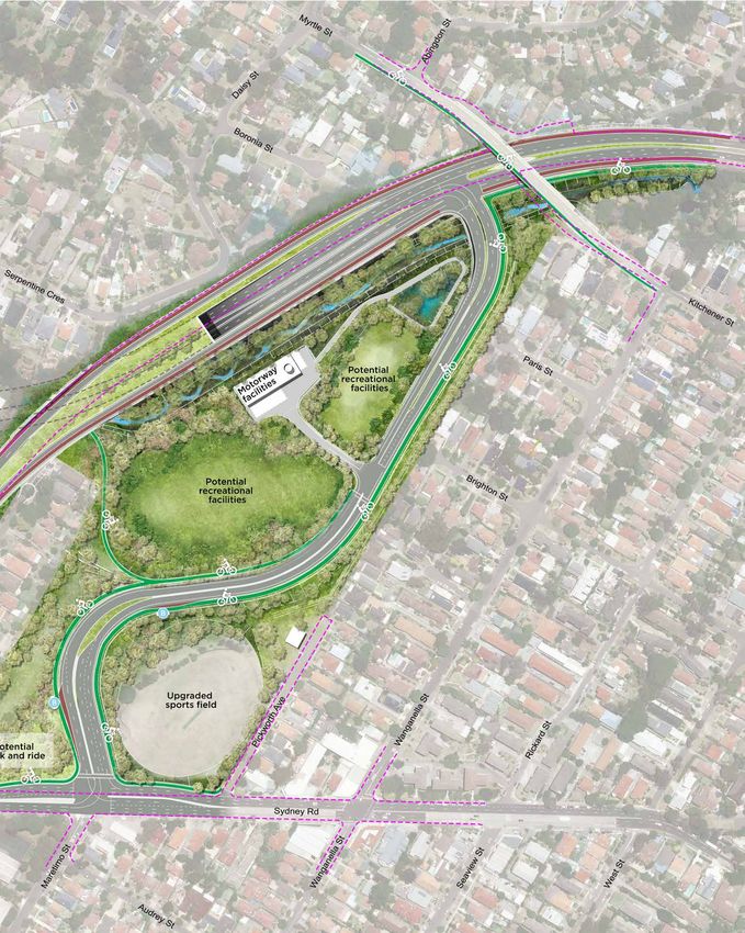
Contents
Project overview................................................................. 4        Western Harbour Tunnel and Beaches Link map...... 19
Project benefits....................................................................5      Stronger measures on tunnel emissions.....................20
Design changes led by community feedback............. 6                                    Design and construction................................................. 22
Design facts and map.......................................................10              Beaches Link vertical alignment ..................................30
Project need ........................................................................ 11   Construction....................................................................... 34
Future Transport 2056..................................................... 12              Immersed tube tunnel construction sequence......... 35
Public transport and active transport.......................... 13                         Safety is the number one priority................................. 36
Integrated planning...........................................................14           Temporary construction sites........................................ 37
Middle Harbour – the challenge.....................................16                      Next steps........................................................................... 48
Middle Harbour – the solution........................................ 17                   Environmental impact assessments............................. 49
Western Harbour Tunnel – companion project.......... 18
Project overview
Beaches Link is a major                Beaches Link includes over
transport infrastructure project       11 kilometres of tunnels as well    Beaches Link will:
                                       as upgrading over five kilometres
that will make it easier, faster
                                       of surface roads.                   •	Improve journey
and safer to get around Sydney.
                                       Beaches Link will be largely           times and reliability
As Sydney continues to grow,           underground and its design has         on critical transport
with more and more trips being         been improved as a direct result       routes on both sides of
made, so will the challenges to        of community feedback.
our transport network.                                                        Middle Harbour
                                       This design work has minimised
Heavily constrained routes to          surface impacts and reduced
                                                                           •	For the first time,
the Northern Beaches impact            property needs.                        provide a motorway
on all road users, including bus                                              link between the
commuters, and Military Road.          Beaches Link
                                                                              Northern Beaches and
Areas such as Mosman, Artarmon         A new tunnel from the Northern         the rest of Sydney
and the Northern Beaches run           Beaches, under Middle Harbour,
the risk of lagging behind the rest    connecting to:                      •	Relieve traffic pressure
of Sydney because of current           •G
                                         ore Hill Freeway for travel         on the North Shore
transport reliability.                  between Manly and the              •	Integrate with
Faster and more reliable trips are      Northern Beaches and
                                                                              Sydney’s public
essential to reducing congestion        Chatswood, Macquarie Park
                                        and North West Sydney                 transport network
and providing new levels of
                                                                              (bus, metro and rail)
access to jobs and services.           •T
                                         he Warringah Freeway for
                                                                              to deliver significant
Beaches Link is key to delivering       journeys to North Sydney,
                                        Sydney central business district      improvements for
the transport vision for Sydney.
                                        (CBD) and Sydney’s south and          bus services.
It will unlock new levels of access     south west.
to jobs, recreation and services,
including health and education,

                                                                             Beaches
across Sydney.
With Beaches Link, people will
spend less time in traffic and
have more time for themselves
                                                                             Link
and their families.                                                          less time in
                                                                             traffic, more
                                                                             time for you

    currently

       69,000 vehicles
                               a day cross     Spit Bridge
                  forecast to carry         80,000 vehicles by 2037
                                                       with 43 bus routes

                                                                                   Woolwich

4      Beaches Link – Project update
                                                                                  Drummoyne
Project benefits
opportunities for
Beaches Link is an integrated Northern
express
transport solution that will improve Beaches
Hospital
buses
car and bus journey times to and Manly and
Northern Beaches
from the Northern Beaches. It will
also provide new connections to St Leonards
St Leonards and Macquarie Park North Sydney
Brookvale
linking people with jobs, education City
and services.
Less traffic on
Wakehurst North Shore roads
Parkway Spit Bridge – 40% less
Connecting More reliable Roseville Bridge – 25% less
the Northern North Shore trips Eastern Valley Way – 35% less
Beaches, south • Reduced pressure on key Military Road – 15% less
and west arterial roads – Military
Road and Warringah Road
• Bypassing 19 sets of
• Greater resilience North Balgowlah
traffic lights through
to incidents and delays
The Spit, Mosman and
Neutral Bay • Reduced rat-run traffic on
local roads – Eastern Valley
• Improved connections
Way, Frenchs Forest Road
to North Sydney and Man
and Ourimbah Road Seaforth
Sydney CBD
Sydney Road
• New connections to
St Leonards and
Macquarie Park
• Access to motorway
Spit Bridge
network for faster
journeys across Sydney
New public
transport options
Artarmon • Operation of express bus
services on Beaches Link
Northbridge to Sydney CBD and
Returning North Sydney
Gore Hill
Freeway streets to local • Direct access to North
Sydney for interchange
communities with the new Sydney Metro
and Sydney Trains
t
Miller S
• Less rat-running through
local streets • Faster, more reliable bus
trips on Military Road and
• Reduced traffic on
Warringah Road
Cammeray arterial corridors
Ernest
St
Falcon
St
Better access to jobs New
Travel time savings community
and business
Brookvale to Sydney CBD
• Over 15 per cent more Northern up to 27 minutes open space Watsons B
Beaches residents will be within
• Opportunity for new open
45 minutes commute to work Dee Why to Sydney Airport space at the Balgowlah
• Local Northern Beaches up to 41 minutes Golf Course site
businesses will benefit from
better access to Greater Sydney
Frenchs Forest to Rozelle • New shared path along
up to 40 minutes the Wakehurst Parkway,
• More direct access will be connecting Seaforth with
available for movement of Manly to Macquarie Park the Northern Beaches
goods and servicesSydney up to 23 minutes Hospital precinct
Birchgrove Harbour
Bridge
Beaches Link – Project update Vaucluse
5
Sydney Harbour
Design changes led by community feedback
In March 2017, the NSW                 We want to hear what you
Government released a project          think about where we are up to.       What we’ve heard
                                       Roads and Maritime Services will
concept and started detailed                                                 Extensive engagement
                                       shortly commence community
design work on the Beaches             engagement on the design              has included over
Link project.                          presented in this document.           5000 face-to-face
Since then, there has been             Once we have heard your               conversations via a
extensive community engagement,        feedback, Roads and Maritime          series of 16 community
geotechnical testing, field studies    will continue to refine the design.   feedback sessions,
and market sounding with                                                     12 shopping centre
                                       The NSW Government will then
the finance and construction
                                       progress this refined design          displays, workshops and
industries.
                                       through the planning assessment       meetings with schools
This project update provides an        process. This will include the        and community groups.
overview of how the proposed           exhibition of Environmental
design has evolved, incorporating      Impact Statements (EISs) when         We have made significant
feedback from community and            the community can provide             changes to the design,
stakeholder groups over the            formal feedback.                      based on what we
past year.
                                                                             have heard from the
                                                                             community.

6      Beaches Link – Project update
Seaforth

What we heard                       How the design addresses this

Concern that tunnel ramps are       Proposed tunnel ramps including ventilation outlets moved
too close to houses and Seaforth    500 metres north from concept design location for superior community
Oval – community proposal           and engineering outcomes
to move ramps further north
on the Wakehurst Parkway to
reduce local impacts

Concern about potential             No access from North Balgowlah into tunnel ramps to avoid local
changes to local roads, including   rat-running
rat-runs through local streets to
access the tunnels

Concern that Seaforth Oval          Temporary construction sites designed to minimise local impacts
sports field will be directly       No impact to Seaforth Oval sports field
impacted by construction
                                    Construction traffic carrying tunnel spoil will head north (not south)
Concern about construction          on the Wakehurst Parkway
traffic on local streets and
around the oval                     Construction traffic separated from traffic using the oval car park

Desire for safe and accessible      New dedicated shared user paths along the Wakehurst Parkway,
active transport and                including a new underpass to connect existing trails of Garigal National
connections to existing             Park and Manly Dam Reserve
cycle and walking trails

Need for design to                  New crossings for fauna provided along the Wakehurst Parkway
accommodate crossings
for wildlife

Concern about a ventilation         Ventilation facility will be located with the tunnel ramps further north on
facility being located near         the Wakehurst Parkway
Seaforth Oval                       Air quality assessment, taking into account local conditions, is being
                                    undertaken and will be included in the EIS

                                                                          Beaches Link – Project update           7
Balgowlah

    What we heard                        How the design addresses this

    Preference for tunnel ramps and      Proposed tunnel alignment changed so tunnel ramps are located in
    construction to use Balgowlah        the centre of Burnt Bridge Creek Deviation
    Golf Course rather than              Revised tunnel alignment avoids impact on homes and bushland west of
    impacting homes, Burnt Bridge        Burnt Bridge Creek Deviation – significantly reducing the number
    Creek bushland or Seaforth           of homes needed for the project
    Public School
                                         Use of Balgowlah Golf Course for major construction site and permanent
                                         facilities including a ventilation outlet and new link road means:
                                            –– Reduced construction impact on local residences and
                                                 Seaforth Public School
                                            –– Less disruption to traffic and buses
                                            –– Opportunity to reconfigure the golf course as community
                                               open space after construction, in consultation with Northern
                                               Beaches Council and the community

    Concern about a ventilation          Ventilation outlet will be located near the tunnel ramps, in the Balgowlah
    outlet being located in the          Golf Course precinct, which is the most efficient location
    Burnt Bridge Creek valley            Air quality assessment, taking into account local conditions including
                                         topography, is being undertaken and will be included in the EIS

     esire to keep the shared user
    D                                    The shared user path crossing Burnt Bridge Creek Deviation will be
    path under Burnt Bridge Creek        maintained throughout and after construction
    Deviation

     oncern about queuing of
    C                                    Improved design of connections to Condamine Street and a new
    vehicles going in and out of the     link road to Sydney Road provide good outcomes for the local
    tunnel ramps and traffic impacts     road network
    on local roads

8        Beaches Link – Project update
Artarmon and Willoughby

What we heard                      How the design addresses this

Concern about impacts              Alternative proposal for Flat Rock Drive construction site which
to sporting facilities in the      eliminates impacts on the Flat Rock Baseball Diamond
Willoughby area

Concern about Artarmon             No impact to Artarmon Reserve sports field
Reserve sports field               No construction site at Artarmon Reserve

Avoid the homes to the north of    No homes acquired in this area
Gore Hill Freeway

Locate the ventilation outlet to   Ventilation outlet will be located in Artarmon industrial area, south of
the south of Gore Hill Freeway     Gore Hill Freeway
in industrial area
                                   An air quality assessment, taking into account local conditions (including
                                   topography) is being undertaken and will be included in the EIS

Concerns about the clearing        Minimise impact to bushland by widening to the south and avoiding
of bushland next to Gore Hill      Artarmon Reserve bushland
Freeway

Desire to be able to access        Access to Beaches Link via Gore Hill Freeway and Reserve Road
Beaches Link

                                                                         Beaches Link – Project update          9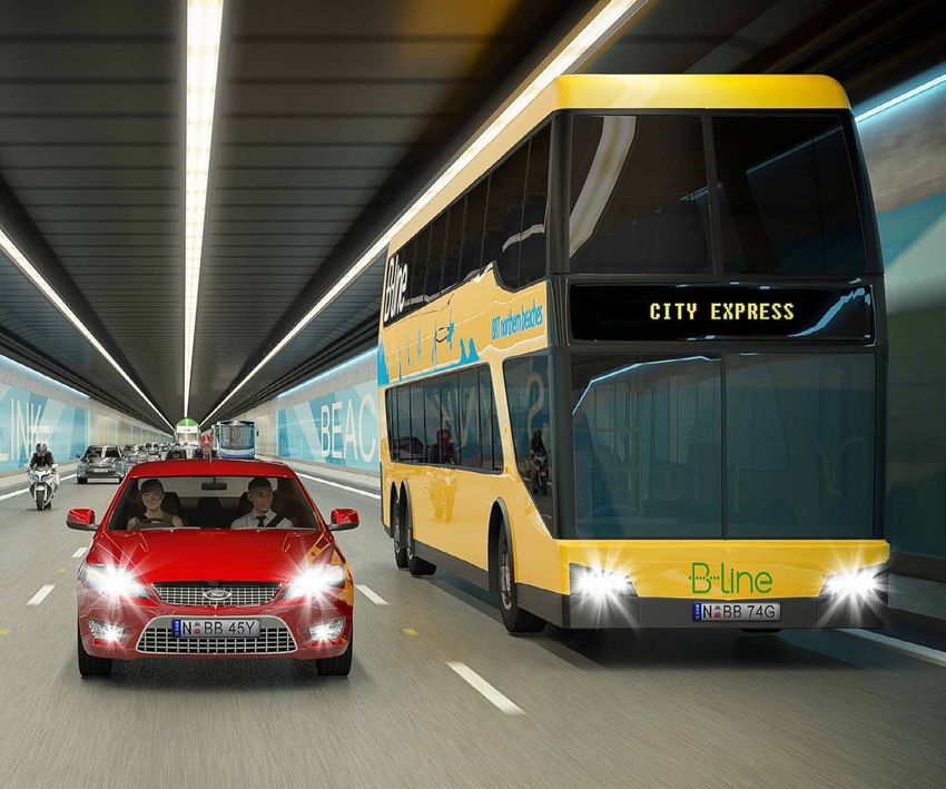
Design facts and map
Beaches Link
Beaches Link
7.2 kilometres Main tunnels three lanes each way
(Cammeray to Balgowlah)
Beaches Link
2.5 kilometres Two lanes each way
(the Wakehurst Parkway connection)
Two lanes each way – Beaches Link ramp
The Wakehurst Parkway upgrade 3 kilometres
to Warringah Road
Beaches Link
2 kilometres Two lanes each way
(connection to Gore Hill Freeway)
Integration of Beaches Link
Surface Works, Gore Hill Freeway Davidson 1.3 kilometres
Northern
Beaches with existing road network
Hospital
Warrin
Frenchs Forest gah Road Dee Why
Davidson Northern
Beaches
Hospital Frenchs Forest
Mona Vale
Narrabeen Warring
Frenchs Forest Terrey Hills ah Roa
d
Dee Why
Forestville
Brookvale
Wa
Frenchs Forest
MonaAllambie
Vale
ke
Heights
Curl Curl
hur
Narrabeen
Terrey Hills
st P
Forestville
a
Brookvale
rkw
Killarney Heights Manly
Freshwater
ay
Brookvale
Wa
Dee Why
ke
Allambie Heights
Lindfield Curl Curl
hur
st P
Queenscliff
St
Roseville North
a
rkw
mine
Killarney Heights Balgowlah Manly
Freshwater
ay
Brookvale
a
e
Castle Cove ridg Dee Why
Cond
t B iation
Lindfield rn Dev
k
Cr Bu
ee
Queenscliff
St
Roseville Middle Cove North
Middle
mine
Chatswood Harbour Balgowlah
Manly
a
Castle Cove dge
SydneyriRoad
Cond
t B iation
rn Dev
Castlecrag Seaforth k
Cr Bu
Balgowlah
ee
Lane Cove Tunnel Middle Cove
Middle Spit Bridge
M2
Chatswood Harbour Manly
NorthConnex
M7 Sydney Road
Balgowlah Heights
Castlecrag Seaforth
Artarmon Balgowlah
Gore Hill Freeway Northbridge
Lane Cove Tunnel Spit Bridge
M2
Sydney CBD
NorthConnex
Reoad
North Sydney
R
M7
se
Airport
Balgowlah Heights
rv
Parramatta
e
Artarmon
Royal North Cammeray
Northbridge
Shore Hospital
Gore Hill Freeway
Lane Cove
Ernest Sydney CBD
St Leonards
St Mosman
Reoad
Falcon North Sydney
R
Crows Nest St
se
Airport Cremorne
rv
Parramatta
e
Miller St
Royal North Cammeray
Shore Hospital Neutral Bay
Lane Cove
Erne
Be rrystStSt Mosman Watsons Bay
St Leonards
Falcon
Crows Nest St
Woolwich North Cremorne
Sydney High St Cremorne Point
Miller St
Neutral Bay
Waverton
Legend Berry St Watsons Bay
Kirribilli
Sydney 0 1km 2km N
Motorways
Woolwich Beaches Link Birchgrove Northern
North Beaches Hospital roadworks
Harbour Cremorne Point
Sydney High St
Wakehurst Parkway Upgrade Bridge Sydney Major roads Vaucluse
Drummoyne Harbour Sydney Harbour
Tunnel
Waverton
Legend
10 Beaches Link – Project update Kirribilli
SydneyBeaches Hospital roadworks Motorways
0 1km 2km N
Beaches Link Birchgrove Northern
Harbour
Wakehurst Parkway Upgrade Bridge Sydney Major roads VaucluseProject need
As Sydney’s population grows,
our economy and jobs will also Beaches Link:
grow, as will the number of trips
made in and around Sydney upports the Greater Sydney
S Supports customer outcomes
every day. Region Plan Future Transport 2056
(Greater Sydney Commission, including enabling 30 minute
Congestion costs our economy 2018) vision for access by public access to jobs and services by
around $6.1 billion a year. transport to the Eastern Harbour public transport, improving
By 2030, this cost is expected City, including Sydney Harbour, the legibility of the transport
to hit $12.6 billion a year. St Leonards, Chatswood and network and improving
Motorway connections, as part of Macquarie Park. freight journey times by
an integrated transport network, better separating local and
upports the Eastern City
S through traffic.
provide critical support to a
and North District Plans
growing economy in a global ligns with Infrastructure
A
(Greater Sydney Commission,
city like Sydney. Australia’s Priority List
2018), special objectives to
Beaches Link is a key initiative maintain the Harbour City’s which is developed by this
for Sydney’s integrated transport economic success and support independent infrastructure
network. It will relieve congestion, sustainable growth of strategic advisor to define the nation’s
improve access by public centres across the North infrastructure priorities.
transport to jobs and services District. The project is listed as a
and increase the efficiency of priority initiative.
By reducing pressure on
the freight network.
arterial roads, the project also
The project has been identified facilitates improvements to
as an infrastructure priority by places in the Eastern City and
both the NSW and Australian North Districts.
Commonwealth Governments.
It supports the NSW
Government’s strategic objectives
for Greater Sydney and delivers
on recommendations made by
Funding
Infrastructure Australia.
In 2018, the NSW Government The NSW Government is Over the next four years, a
delivered a long-term planning investing a record $51.2 billion total $556.2 million has been
and transport blueprint, releasing: over the four years to 2021/22 allocated for the Western
for public transport and roads. Harbour Tunnel and Beaches
• reater Sydney Commission’s
G Link Program.
Greater Sydney Region Plan This represents a $9.8 billion,
and District Plans, which or 23.6 per cent increase on A total of $130 million has
establish a vision for Sydney the four years to 2020/21 been allocated for the 2018/19
as a productive, sustainable included in the 2017/18 financial year for planning and
metropolis of three cities NSW State Budget. early works for the Western
where people can access jobs Harbour Tunnel and
The total amount is comprised
and services within 30 minutes Beaches Link.
of $26.6 billion for public
by public transport transport and $24.6 billion
• Future Transport 2056 for roads.
(see page 12).
Beaches Link – Project update 11Future Transport 2056
By 2056, NSW will have strategically significant roads Within the 10-kilometre area
more than 12 million that move people and goods around metropolitan centres,
residents and Sydney will rapidly over long distances. city-serving corridors will be able
become a global city of Movement corridors and
to support higher frequency,
eight million people, motorways are highly important
reliable on-street public
similar in size to London for the movement of people and
transport while city-shaping
or New York. goods, with a key role to provide
motorways divert major traffic
away from centres.
Planning and investment for efficient movement across the
Greater Sydney will focus road network where there is little This is our vision for the
around the three cities concept interaction with adjacent land integrated network around the
– the Western Parkland City, use. Motorways provide a critical Harbour CBD where the network
the Central River City and the function in taking long distance of new motorways, including
Eastern Harbour City. through-traffic off surface roads WestConnex and Western
when access to places is not Harbour Tunnel will support high
The NSW Government’s
required. volume and capacity of private
Future Transport Strategy is an
vehicles, road-based public
overarching strategy supported The Future Transport vision for
transport and freight movement.
by a suite of plans to achieve the transport network is one
At the same time they will enable
a 40-year vision for our where different road and rail links
busy surface roads, such as
transport system. form part of an integrated and
Parramatta Road, Victoria Road
connected network across the
Future Transport has been and Military Road, to support
Greater Sydney region with each
developed in close collaboration more on-street public transport
of the three cities in a hierarchy
with the Greater Sydney to provide reliable access to land
of corridors performing different
Commission, Infrastructure NSW, uses along these roads.
functions.
the NSW Department of Premier
Motorways such as Beaches Link
and Cabinet and the NSW Motorways can support a
support successful places, a key
Department of Planning and city-shaping function as they
outcome sought from Future
Environment. facilitate higher speed and
Transport 2056. They provide
volume linkages between
Future Transport 2056 identifies for a through-traffic bypass of
cities and centres. While
Beaches Link as a committed places such as the Sydney CBD,
motorways provide access
infrastructure initiative along with facilitate a 30-minute city by
across the metropolitan area
the F6 Extension, Sydney Metro allowing greater surface priority
and to and from regional NSW,
West and Parramatta Light Rail. for public transport, and create
as part of this vision, they are
the opportunity for better places,
As part of the Movement and complemented by city-serving
for example at Neutral Bay
Place Framework outlined corridors better suited to
or Rozelle.
in Future Transport 2056, accessing centres.
motorways are identified as
12 Beaches Link – Project updatePublic transport and active transport
Beaches Link benefits public
transport across the Northern
Beaches, the North Shore,
North Sydney and around
the CBD by opening up new
express bus connections and
adding capacity to existing
corridors.
Beaches Link will:
• Enable direct, reliable public
transport between the
Northern Beaches and North
Sydney as well as south of
Sydney Harbour and new
direct connections to centres
such as St Leonards
• Free up Military Road for
more reliable bus services
through Mosman, Cremorne
B-line bus
and Neutral Bay and ease
pressure on Warringah Road
for bus services through B-Line Bus Active transport
Frenchs Forest, Forestville and
Roseville Bridge Before the new B-Line Bus service Beaches Link delivers over five
was introduced, the Northern kilometres of new cycleways
• Improve bus travel on the
Beaches experienced some of
Warringah Freeway, including and pedestrian paths.
Sydney’s longest peak-hour bus
a new continuous, free-flowing
travel times. New active transport
bus lane between Miller Street
and Sydney Harbour Bridge The new Northern Beaches bus
connections will provide new
and improved access to network, along with traffic flow travel options and create new
North Sydney improvements delivered by paths for recreation.
• nable opportunities for
E B-Line, has already increased
express buses to use bus patronage and reduced New Wakehurst Parkway
Beaches Link. travel times. shared path
Over 2000 weekly B-Line services • Links the new Northern
are now providing an enhanced Beaches Hospital precinct with
Beaches Link public connection between Mona Seaforth, Balgowlah and Manly
transport integration Vale and Wynyard, with further • Integrates with the Garigal
improvements expected from National Park and Manly
By connecting with the
current road upgrades. Dam Reserve trails with safe
Warringah Freeway, Beaches
underpasses and overpasses
Link allows direct access By reducing traffic on existing
to the Sydney CBD and bus corridors, Beaches Link will Balgowlah Recreation precinct
North Sydney – and delivers further enhance the travel time • Provides additional shared
new opportunities for new and reliability benefits created pathways integrated with
express bus services. by B-Line. existing paths to nearby
We are working closely Beaches Link has the potential schools and shops
with Transport for NSW to further expand express bus
to explore opportunities transport for the Northern
for new public transport, Beaches as part of our integrated
including express buses to transport network.
use Beaches Link and then
interchange with Sydney
Trains and Sydney Metro at
North Sydney.
Beaches Link – Project update 13Integrated planning
As a large urban expanse, Beaches Link complements
Greater Sydney is reliant on other major NSW Government
strategic centres across the initiatives:
metropolitan area to provide
B -Line
employment and services.
Beaches Link will provide the Richmond
Ensuring these centres are opportunity to the new Northern
connected with each other Beaches B-Line by enabling
and the rest of Sydney by an express services through Beaches
effective integrated transport Link and reduced pressure on
network is fundamental to existing arterial routes.
supporting access to jobs,
housing, recreation and services; Sydney Metro
facilitating business-to-business Beaches Link will enable direct
NORTH WE
connections and attracting connections to Sydney Metro. PRIORITY LA
RELEASE A
investment. For example, the interchange for
This requires a range of transport Beaches Link express buses at
modes, including mass transit Victoria Cross Station in North
solutions such as heavy rail or Sydney will increase the Metro
PENRITH
metro rail, and other solutions, catchment area and will provide M7
St Marys
including bus, light rail, a fast, one-transfer journey
motorways and active transport. between the Northern Beaches M4
and Greater Sydney. North South
Rail Line WESTERN SYDNE
EMPLOYMENT
Northern Beaches Hospital AREA
Beaches Link will connect to the
new Northern Beaches Hospital Luddenham
precinct, providing a direct WESTERN
M12
connection to the Warringah and SYDNEY Badgerys
AIRPORT Creek C
Gore Hill Freeways and enabling
new routes to St Leonards and Bringelly
WESTERN
SYDNEY
Macquarie Park. AIRPORT
WESTERN SYDNEY
PRIORITY GROWTH
AREA
The Northern Road
SOUTH WEST
PRIORITY GROWTH
AREA
Narellan
Camden
CAMPB
Macarthur
Appin
Proposed Victoria Cross interchange. Image courtesy Sydney Metro.
14 Beaches Link – Project updateBrooklyn
Brooklyn
Legend
Legend NN
Existing
Existing motorways/highways
motorways/highways
Projects completed
Projects completed
Hornsby WestConnex New M4 widening
Hornsby M1 Mona Vale WestConnex New M4 widening
M5 widening
Cudgegong M1 Mona Vale M5 widening
Road
Public transport in delivery
EST
AND Public transport
B-Line in delivery
AREA
Sydney Metro Northwest
etro Wahroonga B-Line
ey M NorthConnex
Sydnhwest Sydney Metro City and Southwest
Nort Sydney Metro Northwest
etro Wahroonga Frenchs Forest
ey M
City & South East Light Rail
NorthConnex
Sydnhwest Sydney Metro City and Southwest
No rt Frenchs
NORTHERN Forest
West Pennant Hills B-Line City transport
Public & South East Light Rail
in planning
BEACHES
Baulkham Hills HOSPITAL Parramatta Light Rail
M2 West Pennant Hills NORTHERN Brookvale
B-Line Public transport
Sydney in planning
Metro West
BLACKTOWN BEACHES
Epping
Baulkham Hills HOSPITAL North South
Parramatta RailRail
Light Line
M2 GREATER Carlingford Chatswood Brookvale
Balgowlah Sydney Metro West
M4 Smart Motorway PARRAMATTA
Epping Motorway projects in delivery
Spit Bridge North South Rail Line
Artarmon NorthConnex
EY GREATER M4 Carlingford Chatswood
Westmead Balgowlah WestConnex New M4 tunnel
PARRAMATTA Holroyd
SYDNEY
Motorway projects in delivery
OLYMPIC Spit Bridge WestConnex New M5
PARK Artarmon NorthConnex
W WestConnex M4-M5 Link
Westmead Ne estC
w on WestConnex New
The Northern M4 tunnel
Road
SYDNEY
M4 ne Homebush Drummoyne
Holroyd wi x
OLYMPIC
de West M4 Smart Motorway
WestConnex New M5
n
PARK ing W SYDNEY
W Ne estCo Rozelle CITY WestConnex M4-M5 Link
Fairfield
Ne estC ext w M4 nnex
ens tun Major transport projects in planning
w on ion ne The Northern Road
Cecil Hills M4 ne Homebush Drummoyne l WestConnex Warringah Freeway Upgrade
wi x M4-M5 Link M4 Smart Motorway
de
nin West Bondi Junction Western Harbour Tunnel
g W SYDNEY GREEN SQUARE
Ne estCo Rozelle
tro st
CITY /MASCOT Beaches Link
rfield Me thwe
ext w M4 nnex ydneynd Sou Mascot RANDWICK Major transport projects
F6 Extension in planning
– Stage 1
ens tun S y a Sydenham
LIVERPOOL Bankstownion neCit HEALTH AND F6 Extension – Kogarah to Loftus
l WestConnex St Peters Warringah Freeway Upgrade
EDUCATION
M4-M5 LinkWolli Creek Interchange
Bondi Junction M12
Beverly Hills Western Harbour Tunnel
SYDNEY
M5 Widening M5 ex GREEN SQUARE
AIRPORT
Sydney Gateway
tro st
Riverwood onn /MASCOT Beaches Link
Revesby Me thwe stC 5 The Northern Road
ney Sou We w M F6 Extension – Stage 1
Sydy and Ne Mascot RANDWICK T4 and T8 Rail Upgrades
Bankstown Cit Sydenham
Hurstville HEALTH AND More Trains
F6 Extension – More Services
Kogarah to Loftus
St Peters
T4 and T8 Rail Upgrades Wolli Creek KOGARAH
Interchange EDUCATION
PORT
Glenfield BOTANY M12
More Trains Beverly Hills
More Services HEALTH AND
EDUCATION SYDNEY
La Perouse Growth areas
Sydney Gateway
M5 Widening M5 ex AIRPORT
Riverwood onn North West Land Release Area
Revesby stC 5 The Northern Road
We w M
Ne Western Sydney Priority Growth Area
T4 and T8 Rail Upgrades
Hurstville More Trains
South More
West Services
Priority Growth Area
T4 and T8 Rail Upgrades KOGARAH PORT
d BOTANY
Western Sydney Airport
More Trains More Services SUTHERLAND HEALTH AND
EDUCATION La Perouse Growth areas
Western Sydney Employment Area
Cronulla North West Land Release Area
Western Sydney Priority Growth Area
BELLTOWN
South West Priority Growth Area
Heathcote
Western Sydney Airport
SUTHERLAND
Western Sydney Employment Area
Cronulla
Waterfall
Heathcote
Wollongong,
Port Kembla,
Kiama
Waterfall
Wollongong, Beaches Link – Project update 15
Port Kembla,
KiamaMiddle Harbour – the challenge
Military Road –
Sydney’s worst
traffic?
A recent study by the
Grattan Institute found
Sydney’s worst traffic
congestion is from Manly,
across The Spit, through
Mosman and Cremorne
to the city.
Motorists from the Northern Due to the limited access and
Beaches experience long and extensive congestion, routes to
and from the Northern Beaches
unreliable journey times.
are vulnerable to incidents
and delays.
Just three arterial roads
serve the Northern Beaches: Congestion on the Spit Bridge
– Military Road and Warringah
Spit Bridge Road – Roseville Bridge corridors
• he only ‘opening’ bridge
T has significant impacts on the
on the Sydney road network North Shore.
• C arries 69,500 vehicles a day Congestion also causes some
• orecast to increase to over
F traffic to use local roads, such
74,500 vehicles a day as Ourimbah Road in Mosman,
by 2027. Frenchs Forest Road in Seaforth
and Eastern Valley Way in
Warringah Road Willoughby. The Northern Beaches
On average
between• Carries 78,500 vehicles a day This impacts the amenity of B-Line is delivering
2014 and 2017
• orecast to carry 83,000
F suburbs including Cremorne, important benefits to
1,400 Harbour vehiclesSydney
a day by 2027. Mosman, Neutral Bay, Seaforth,
Willoughby and Roseville.
bus customers.
These benefits will be
$66.4m
Mona Vale Road
Bridge
incidents on It also impacts bus andaverage
car annual cost to
• and Warringah
Carries 57,400 vehicles a day enhanced as a result
the
journey times for people in economy in 2036
Freeway every year of Beaches Link.
• orecast to carry 61,200
F these areas.
vehicles a day by 2027.
On average
between
2014 and 2017
550 Spit Bridge &
Military Road
incidents on Limited alternate routes lead to a
every year network vulnerable to incidents
16 Beaches Link – Project updateMiddle Harbour – the solution
Beaches
Link
• For the first time, a direct,
free-flowing connection
between the Northern
Beaches and the rest of
Sydney
• A seven-kilometre integrated
transport tunnel crossing
under Middle Harbour
connecting the Northern
Beaches to the Warringah
Freeway and Gore Hill
Freeway
• Less pressure on Spit
Bridge and Military Road
– improving amenity in
Mosman, Cremorne and
Neutral Bay – and relieving
traffic flows through
Roseville and Willoughby
• irect Warringah Freeway
D
access for fast and reliable
access to North Sydney, the
Sydney CBD and beyond
• A fast, reliable link between
the Northern Beaches and
key centres including
St Leonards and Macquarie
Park via direct Gore Hill
Freeway connection
• Opportunity for additional
express bus services and
improved connections to
Sydney Trains and the new Morning peak travel times in 2027, with and without Western Harbour Tunnel and Beaches Link
Sydney Metro (WHTBL)
• Widening the Wakehurst
Parkway to two lanes each Without With Percentage
Origin Destination WHTBL WHTBL faster
way between the Wakehurst
Parkway tunnel ramps and Balgowlah North Sydney 32 mins 14 mins 57%
Frenchs Forest
• Pedestrian and cyclist Brookvale Sydney CBD 57 mins 30 mins 48%
pathways including safe
crossings of the Wakehurst
Chatswood Sydney Airport 50 mins 30 mins 41%
Parkway and connections
to the Northern Beaches
Hospital precinct Dee Why Sydney Airport 75 mins 34 mins 55%
• Opportunity for new open
space in Balgowlah to be Manly Macquarie Park 47 mins 24 mins 49%
developed in consultation
with council and community Manly Parramatta 78 mins 53 mins 32%
• ess traffic on major arterial
L
roads across the North Mosman Sydney Airport 48 mins 30 mins 38%
Shore, improving urban
amenity and travel times.
* Based on 2027 traffic forecasts.
Beaches Link – Project update 17Western Harbour Tunnel – companion project
Western Harbour Tunnel is a It will change the way people
move around Sydney and how
major transport infrastructure Western Harbour
people travel between the North
project that will make it easier, Tunnel will:
Shore, the CBD and Western and
faster and safer to get around Southern Sydney.
Sydney. • Create a western
With Western Harbour Tunnel, bypass of the CBD
Sydney Harbour Bridge and people will spend less time in
Sydney Harbour Tunnel are at the traffic and have more time for
and take pressure
heart of Sydney’s road transport themselves and their families. off Sydney Harbour
network. Bridge, Anzac
Western Harbour Tunnel
Both are now at over-capacity includes over six kilometres of
Bridge and Western
and a single incident can have tunnels as well as upgrading over Distributor
a major flow-on effect on travel nine kilometres of surface roads. • Integrate with public
times across the transport
network and impact our
Largely underground, the transport, improve
proposed reference design for travel times and
economy.
Western Harbour Tunnel will have
boost reliability for
As Sydney continues to grow, minimal impacts to communities
with more and more trips being and significantly reduce property
cross-harbour trips
made, so will the challenges to needs. and the broader
our transport network. network
The project includes:
This is why the NSW Government • Provide core
is investing $51.2 billion across Western Harbour Tunnel –
capacity that enables
NSW on roads and public a new tunnel from the
WestConnex Rozelle Interchange, improved links across
transport to deliver an integrated
transport solution for Greater under Sydney Harbour to the Sydney.
Sydney. Warringah Freeway.
Warringah Freeway Upgrade –
Western
Western Harbour Tunnel is key to
delivering this transport vision. streamlining Australia’s busiest
road.
Harbour
Tunnel
For further detail on
Western Harbour Tunnel go to
www.rms.nsw.gov.au/whtbl
less time in
traffic, more
time for you
more than
4.3 million people
cross Sydney Harbour Bridge and Tunnel
by car, bus and train every week
18 Beaches Link – Project updateWestern Harbour Tunnel and Beaches Link map: Oxford Falls
combined projects
Beaches Link has been Davidson
developed with Western Northern
Beaches
Hospital
Harbour Tunnel as part of
Warrin
a program of works due
ga h Road
Frenchs Forest
to the design interface at
the Warringah Freeway. Frenchs Forest
Mona Vale
Narrabeen
Forestville Terrey Hills
Brookvale
Wa
keh
Allambie Heights
Curl Curl
urs
t Pa
rkw
Killarney Heights Manly
Freshwater
ay
Brookvale
Dee Why
Lindfield
Queenscliff
St
Roseville North
mine
Balgowlah
a
e
Castle Cove ridg
Cond
t B iation
rn Dev
k
Cr Bu
ee
Middle Cove
Middle
Chatswood Harbour Manly
Sydney Road
Castlecrag Seaforth Balgowlah
Lane Cove Tunnel Spit Bridge
M2
NorthConnex
M7
Balgowlah Heights
Artarmon
Gore Hill Freeway Northbridge
Sydney CBD
Reoad
R
se
North Sydney
rv
Airport
e
Parramatta
Lane Cove Royal North
Shore Hospital
Cammeray
Ernest
St Leonards
St Mosman
Falcon
Crows Nest St
Miller St
OFF
RAMP Cremorne
Neutral Bay
ON
Berry StRAMP
North Watsons Bay
Woolwich Sydney
High St Cremorne Point
Waverton
Kirribilli
Sydney
Birchgrove Harbour
Bridge Sydney Vaucluse
Drummoyne Harbour Sydney Harbour
Tunnel
Balmain
M4 WestConnex
Parramatta
Blacktown Rozelle
Penrith Rozelle Point Piper
Potts
Interchange Pyrmont Point
Darling Point
Anzac Bridge
Lilyfield
City West Link M5 WestConnex
Glebe Glebe Point Airport
Port Botany
Campbelltown
Legend
0 1km 2km N
Beaches Link Wakehurst Parkway Upgrade Motorways
Western Harbour Tunnel WestConnex Major roads
Warringah Freeway Upgrade Northern Beaches Hospital roadworks
Beaches Link – Project update 19Stronger measures on tunnel emissions
Sydney’s air quality our population grows, total Recent NSW tunnels longer than
emissions from motor vehicles one kilometre are required to have
Sydney’s air quality is good are expected to continue to fall zero ramp emissions, whereas
by national and international over the next decade due to new, outside Australia almost all road
standards. cleaner vehicles replacing older tunnels have ramp emissions.
technology vehicles.
In NSW, the Office of To achieve zero ramp emissions,
Environment and Heritage (OEH) Modern tunnel ventilation jet fans draw in air from the exit
monitors, analyses and publishes ramp to ensure a net inflow of
Beaches Link will be designed air at the ramp so that all tunnel
information about air quality.
to achieve: emissions are removed through
The Environment Protection • Strict in-tunnel air quality an elevated ventilation outlet.
Authority (EPA) regulates air limits
quality and implements measures This is most efficiently done
• No emissions from ramps when the ventilation outlet is
for managing and reporting
air pollution. • Emissions from ventilation positioned near the exit ramp,
outlets indistinguishable from reducing ongoing energy use and
Despite there being more cars on improving effectiveness.
background air quality.
the road, a number of initiatives
and technological developments In-tunnel air quality is achieved This is why all ventilation outlets
in both engine emissions and by ensuring sufficient air flow for Western Harbour Tunnel and
fuel quality have resulted through the tunnel to prevent the Beaches Link will be located near
in substantial reductions to build up of vehicle emissions. tunnel exit ramps.
Sydney’s vehicle emissions over
The air flow is achieved through a Locations of ventilation outlets
the past two decades.
combination of traffic flow, tunnel for Beaches Link are shown on
Although the number of cars is size and ventilation design the maps for tunnel ramps on
expected to further increase as (jet fans). the following pages.
Australia’s air quality standards
are stringent by global standards
Stockholm
Australian Standard (8 µg/m3)
WHO Guideline (10µg/m3)
US National Standard (12µg/m3)
EU Air Quality Limit (25µg/m3 )
Brisbane
Hobart
Canberra
Cars built
after 2013 emit 97% less
oxides of nitrogen than
Vancouver
Illawarra vehicles built in 1976
Adelaide
Sydney
Melbourne
Perth Diesel trucks
San Francisco built after 2013
New York
Helsinki
emit
92% less particles
of matter
Madrid
than
Montreal trucks built
Zürich in 1996
London
Berlin
Rome
Paris
Singapore By 2036 there will be a
0 10 20 30
48%
Air quality in Sydney and internationally
decrease
Annual Average PM 2.5 Concentrations µg/m 3 in PM2.5 vehicle
Source: World Health Organization emissions since 2003
20 Beaches Link – Project updateBeaches Link will have elevated Assessment and regulation he NSW Chief Health Officer
T
ventilation outlets that are very will release a statement on the
The NSW Government has
effective at ejecting tunnel air high potential health impacts of
announced stronger measures
into the atmosphere through a emissions from tunnel ventilation
on emissions from motorway
combination of buoyancy outlets.
tunnels.
and speed.
The Minister for Planning will
The NSW Environment Protection
Once in the atmosphere, the not approve a motorway tunnel
Authority will regulate the
ejected tunnel air dilutes hundreds project until the ACTAQ scientific
ventilation outlets of all current
of times as it mixes with the review is considered.
and future operating motorway
surrounding air and becomes
tunnels in NSW, including the The Beaches Link tunnel will be
indistinguishable from background
new Beaches Link tunnel. subject to stringent assessment
levels.
of the tunnel ventilation systems
The EPA will require tunnel
The effectiveness of a ventilation and ambient air quality in
operators to meet air quality
outlet design in dispersing tunnel surrounding areas.
limits and undertake air quality
air under all operating and weather
monitoring. Further reading
conditions is assessed through
specialised computer modelling Additional checks will be required Roads and Maritime interactive
using actual hour-by-hour weather before determination of the portal on air quality:
data for a full year. Environmental Impact www.rms.nsw.gov.au/air quality
Statements for the project.
Once complete, Beaches Link will NSW Chief Scientist and
be continuously monitored at the The Advisory Committee on Engineer:
ventilation outlets to control the Tunnel Air Quality (ACTAQ) will www.chiefscientist.nsw.gov.au/
ventilation system. coordinate a scientific review of reports/advisory-committee-on-
the project’s air emissions from tunnel-air-quality
This will ensure that strict limits
ventilation outlets. ACTAQ, which
outlined in the approval conditions
advises the NSW Government
are complied with at all times.
on tunnel ventilation design and
Once operating, air quality operation, is convened via the
monitoring data will be publicly Office of the NSW Chief Scientist
available on the new motorway and Engineer.
website.
Emissions readily dispersed
Air quality monitors
Artist’s impression of longitudinal tunnel ventilation system.
Beaches Link – Project update 21Design and construction 22 Beaches Link – Project update
This section of the project update
provides information about the
proposed reference design for an
integrated transport solution that
includes Beaches Link and the
Gore Hill Freeway connection.
Most of this project will be deep
underground in tunnels.
Community and stakeholder
input over the last year has
resulted in significant design
changes to the project.
Roads and Maritime wants to
hear what you think about this
proposed reference design.
Roads and Maritime will
shortly commence community
engagement on the design
presented in this project update.
Balgowlah connection – indicative layout
Community input has led to                  Benefits
major design changes for the                •   This provides the opportunity
Balgowlah connection.                           to reconfigure the golf course
                                                after construction to provide
The Balgowlah connection
                                                much needed new open space
provides access between
                                                for the community (see below)
Beaches Link and the southern
area of the Northern Beaches                •   The new design greatly
peninsula, including Seaforth,                  reduces local impacts. It
Manly and Brookvale.                            requires significantly less
                                                private property and preserves
Key features                                    the Burnt Bridge Creek green
•    The Beaches Link tunnel ramps              space west of Burnt Bridge
     will emerge in the centre of a             Creek Deviation
     widened Burnt Bridge Creek             •   The new link road reduces
     Deviation to the south of                  pressure on other key roads
     Kitchener Street                           such as Pittwater Road and
•    The existing Kitchener Street              Condamine Street and takes
     over-bridge will be lengthened             pressure off the intersection of
     and re-aligned with clearances             Burnt Bridge Creek Deviation,
     increased to 5.2 metres to                 Sydney Road and Manly Road
     allow safer passage of large           •   This link road provides the
     vehicles in and out of the                 opportunity for express bus
     tunnels                                    services to connect to the
•    There will be a new link road              Sydney transport network
     between Burnt Bridge Creek             •   There is the potential for
     Deviation and Sydney Road                  additional bus stops to be
•    Motorway facilities and a                  integrated into the design
     ventilation outlet will be             •   The new design maintains
     located within the current                 active transport along the
     golf course area. These will be            underpass of Burnt Bridge
     housed in a structure designed             Creek Deviation and provides
     to blend with the urban                    new shared user paths.
     environment.

     Future use
     •   The opportunity exists to              •   The final layout of the
         reconfigure the golf-course                site will be developed by
         site following construction of             Council in consultation with
         Beaches Link                               the community and key
                                                    stakeholder groups
     •   Roads and Maritime will
         continue to work with Northern         •   The existing sports field
         Beaches Council on plans for               at Balgowlah Oval will be
         the precinct, in consultation              accessible and remain intact
         with the local community                   throughout construction
     •   After construction, it is              •   The existing scout hall is
         envisaged Roads and                        unaffected and will remain
                                                                                   To Seaforth
         Maritime will leave a terraced,            accessible at all times
         grassed area in a form that is
         compatible with the future final       •   The existing shared path
         layout of the site, as developed           access under Burnt Bridge
         by Northern Beaches Council                Creek Deviation will
                                                    remain open.

24        Beaches Link – Project update
To Brookvale and Dee Why
Beaches Link ramps
Tunnel alignment
Edge of existing road
N
Bus lane
B Potential bus stop
Ventilation outlet
Active transport
To Manly
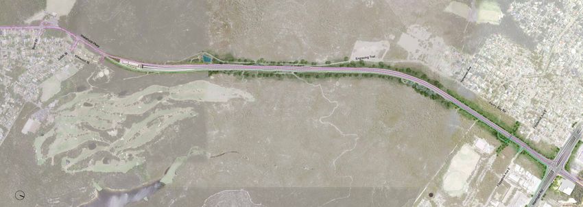
Beaches Link – Project update 25The Wakehurst Parkway Upgrade
The Wakehurst Parkway connection New fauna and bushwalking underpass
B
B
See page 28 for a closer view of
the Wakehurst Parkway connection
New fauna underpass
Tunnel alignment
Edge of existing road
N
B Potential bus stop
Ventilation outlet
Active transport
The Wakehurst Parkway will be Key features
a key link between Warringah • Widening to two lanes in • Multiple shared connections
Road (and suburbs to the each direction between across the Wakehurst Parkway
north) and Beaches Link at the Wakehurst Parkway
• Wildlife crossings over and
Seaforth, improve connectivity connection and Warringah
under the widened Wakehurst
to the Northern Beaches and Road
Parkway.
peninsula and reduce pressure • Free-flowing traffic
on Warringah Road. environment with a posted
speed of 80 km/h
• Three-kilometre-long
shared user path connecting
Seaforth / North Balgowlah
with the new Northern
Beaches Hospital precinct
• Bus stop bays on both sides
of the Wakehurst Parkway
26 Beaches Link – Project updateNew fauna underpass
Renewed pedestrian bridge
New bushwalking and cycle underpasses B
B
Connection to Northern Beaches
Hospital road upgrade
Benefits
• All works will be within the
existing road reserve and clear
of Garigal National Park and
Manly Dam Reserve
• The upgrade improves
recreational connectivity
between Frenchs Forest and
Seaforth
• Wildlife crossings facilitate
safe crossing of the Wakehurst
Parkway for fauna and provide
a safer journey for motorists
• The upgrade improves access
to the north of the Northern
Beaches Peninsula New Active
• The trails in Garigal National fauna transport
Park and Manly Dam Reserve crossings options
are safely connected.
Beaches Link – Project update 27The Wakehurst Parkway connection
N Tunnel alignment
Edge of existing road
To Seaforth
Ventilation outlet
Active transport
Beaches Link ramps
To Warringah Road
Moto
r
facilit way
ies
The Wakehurst Parkway Key features • The design incorporates key
connection will join Beaches features from submissions
• Tunnel ramps will emerge in
developed by local residents
Link to the Wakehurst the centre of a re-designed
and workshopped with the
Parkway – a key arterial route and widened the Wakehurst
project team
that provides direct access Parkway to provide for free-
flowing traffic bypassing • South of the Beaches Link
to Warringah Road, Frenchs
Seaforth tunnel ramps, the Wakehurst
Forest and the north of the Parkway will remain one lane
Northern Beaches peninsula, • Motorists who do not wish in each direction.
as well as acting as a to enter the Beaches Link
tunnels will use a southbound Benefits
Seaforth bypass.
slip lane to stay on the • The design will ensure there
The proposed location of the Wakehurst Parkway are no operational impacts
tunnel ramps is 300 metres • Motorists travelling north from Beaches Link upon key
north of Kirkwood Street. on the Wakehurst Parkway local streets such as Kirkwood
will merge with the widened and Judith Streets, as well as
Wakehurst Parkway, just north Seaforth Oval
of the ramps • All works will be within the
• A motorway facility and existing road reserve and clear
ventilation outlet will be of Garigal National Park and
located above the tunnel the Manly Dam Reserve
ramps in the centre of the • The connection will improve
Wakehurst Parkway access to the north of the
Northern Beaches Peninsula
• A shared path connection including the Northern
along the Wakehurst Parkway Beaches Hospital precinct
will link Seaforth / North
Active Balgowlah to the Northern • Provides opportunity for
transport Beaches Hospital precinct additional express bus
services to access the Sydney
options transport network.
28 Beaches Link – Project updateGore Hill Freeway connection
N Tunnel alignment
Edge of existing road
To Lane Cove Tunnel
Ventilation outlet
Active transport
Beaches Link ramps
Artarmon Reserve
ay
Motorw ntre
Contro
l Ce
To Sydney CBD
t
Suppor
Tunnel ity
Facil
The Gore Hill Freeway Key features Benefits
connection provides a direct • Beaches Link entry ramp • Provides relief to Warringah
connection between Beaches travelling eastbound Road and Roseville Bridge
Link and Sydney’s west and corridor
• Two Beaches Link exit ramps
north-west via the Lane travelling westbound • Takes traffic off local roads
Cove Tunnel. such as Eastern Valley Way
• Beaches Link motorway
and Boundary Street
The ramps emerge within and control centre located in the
Artarmon industrial area • Improves the connectivity and
next to the existing Gore Hill
accessibility from Northern
Freeway corridor between • A motorway facility and
Beaches to major employment
Reserve Road and the North ventilation outlet located in
areas such as Macquarie Park,
the Artarmon industrial area
Shore Rail Line. St Leonards, Artarmon and
on the corner of Punch Street
Royal North Shore Hospital
and Lambs Road.
• No residential properties in
the Artarmon area are
required for the project
• No impact on Artarmon
Reserve.
Keep
trucks off
local streets
Beaches Link – Project update 29Beaches Link vertical alignment
Cammeray to Balgowlah
Most of the project will be deep underground in tunnels. This greatly reduces surface impacts,
including to private property, communities and the environment.
The tunnels, built mostly through high-quality Sydney sandstone, will be engineered and constructed
by industry leaders using world-class technology, and will be world’s best practice in terms of safety,
efficiency and road user experience.
The vertical alignment diagrams show the approximate depth of the tunnels below the surface along
the alignment of the Beaches Link tunnel.
The depths, shown in metres, are measured from ground level to the road surface in the tunnel.
Towards Warringah Freeway
CAMMERAY NAREMBURN NORTHBRIDGE
30 Beaches Link – Project updateSEAFORTH BALGOWLAH
* All measurements in metres
Overview Map
Frenchs
Forest
Balgowlah
Artarmon
Mosman
Rozelle
Sydney
CBD
Beaches Link – Project update 31Beaches Link vertical alignment
The Wakehurst Parkway ramp
Towards Middle Harbour
SEAFORTH NORTH BALGOWLAH
Gore Hill Freeway connection
Overview Map
Frenchs
Forest
ARTARMON
Balgowlah
Artarmon
Mosman
Rozelle GORE HILL FREEWAY CONNECTION
Sydney
CBD * All measurements in metres
32 Beaches Link – Project updateOverview Map
Frenchs
Forest
Balgowlah
Artarmon
Mosman
THE WAKEHURST PARKWAY CONNECTION
Rozelle
Sydney
* All measurements in metres CBD
Willoughby Rd
WILLOUGHBY Towards Middle harbour
Beaches Link – Project update 33Construction
On a global scale, building a Spoil from tunnels is a clean and As with many harbours around
major tunnel beneath Middle stable fill material, being essentially the world that have an industrial
crushed rock, which is generally heritage, Sydney Harbour has
Harbour as part of a network
beneficially reused at development levels of contamination in some of
of new road tunnels will be sites across Greater Sydney. Unless the bed sediments.
a significant engineering a specific opportunity exists to use
Suitable processes for the
achievement. spoil as part of the site restoration,
removal and disposal of such
all of the spoil will be transferred
The majority of the project will be sediment, and construction in
away from the construction site
in deep tunnels, greatly reducing such marine environments, are
to suitable end locations.
surface construction impacts and well understood both domestically
the need for private properties. Tunnelling will be undertaken and internationally. We have taken
24 hours a day, seven days a week expert advice from local and
To build the tunnels and surface to deliver benefits as soon as international experts in preparing
works, construction sites are possible; however hours for spoil our design and proposed
needed to ensure that: haulage will be limited to reduce methodology for handling and
• unnels and surface works
T community impacts. managing sediment.
seamlessly integrate with the Marine sediment removal is
2. Waterway crossings
existing road network and done routinely to keep shipping
connect users to destinations Building the crossing of Middle
channels operational, to enable
• Construction machinery, Harbour using immersed tube
infrastructure works, and to
equipment and materials can tunnelling – a proven methodology
remediate marine environments.
be stored safely adopted on many global road and
rail tunnel projects (including the Ultimately, these materials
• onstruction personnel have
C are removed from the marine
existing Sydney Harbour Tunnel).
appropriate amenities environment, cleaning up the area
The construction strategy has
• here is adequate access to
T in which the works were actually
been chosen because it:
construction areas for removal undertaken.
of excavated material and • Is most suited to the cross
delivery of raw materials such section of a modern motorway The project team is working
as concrete and steel – reducing excavation and with key maritime stakeholders,
spoil haulage including Port Authority of NSW,
• here is enough space to
T the Harbour Master and Transport
build the project safely and • Reduces geotechnical risk
associated with tunnelling for NSW to ensure the appropriate
efficiently. management of impacts to
under Sydney Harbour and
All these measures ensure commercial shipping, ferries,
Middle Harbour – making it
the project can be delivered recreational activities and other
safer to build
safely while minimising overall harbour uses.
construction times and levels of • rovides the lowest vertical
P
impact to communities, the road grades – making it easier for
network and the environment. cars and heavy vehicles and Construction of an
reducing vehicle emissions
Tunnel construction immersed tube tunnel
• Provides the shortest and most
• Excavation for the immersed
After extensive assessments efficient route.
tube tunnels and their
by a multi-disciplinary team with Immersed tube tunnels have construction will be subject
local and international experience been successfully delivered to stringent environmental
(including design, construction in sensitive and highly utilised safeguards
and environment specialists) marine environments across the
the preferred method for • eabed excavated to
S
world, with this experience being
building the tunnels is: prepare trench that tunnel
captured by the project team.
units will be laid into
1. Land tunnels The location and technique has • Immersed tube tunnel units
been developed after careful are fabricated elsewhere
Using multiple roadheader
consideration of sensitive and then towed into place
machines to cut through
marine habitats, natural water above the excavated trench
sandstone at depths of up
flows, contamination, existing
to 100 metres below Sydney – • Immersed tube tunnel units
uses and heritage items, and
methodology proven on all are then lowered one at a
will be constructed under strict
road tunnels constructed in time, creating the tunnel.
environmental regulation.
Sydney to date.
34 Beaches Link – Project updateYou can also read