Lower Thames Crossing - The case for the project - Statutory Consultation 2018 - Citizen Space
←
→
Page content transcription
If your browser does not render page correctly, please read the page content below
Lower Thames Crossing

                                       Volume X.X
     The case for the project

         Statutory Consultation 2018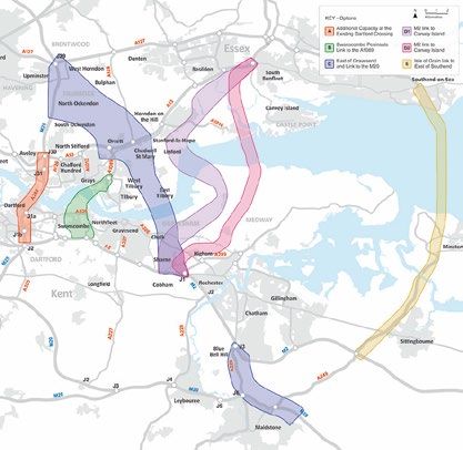
Lower Thames Crossing                                                                                          Case for the Project

                                      Lower Thames Crossing
                                           Case for the Project

                                                       List of contents

                                                                                                                    Page number

       Introduction ............................................................................................................... 1
       About the Lower Thames Crossing ......................................................................... 2
       2.1       Background....................................................................................................... 2
       2.2       The Project ....................................................................................................... 2
       2.3       Development consent ....................................................................................... 2
       2.4       Highways England ............................................................................................ 3
       2.5       Glossary............................................................................................................ 3
       Why we need the Lower Thames Crossing ............................................................. 4
       3.1       Traffic problems east of London ....................................................................... 4
       Benefits of a new crossing ....................................................................................... 7
       4.1       Quicker, more reliable journeys ........................................................................ 7
       4.2       Connecting communities and business............................................................. 7
       4.3       Economy ........................................................................................................... 7
       4.4       Environment...................................................................................................... 7
       How the route was chosen ....................................................................................... 8
       Our objectives ......................................................................................................... 14
       6.1       Introduction ..................................................................................................... 14
       6.2       How we achieve these objectives ................................................................... 14
       Road user charging ................................................................................................. 24
       7.1       Policy and objectives ...................................................................................... 24
       7.2       Proposal.......................................................................................................... 24
       Regulatory framework............................................................................................. 25
       8.1       Introduction ..................................................................................................... 25
       8.2       European and national policy.......................................................................... 25
       8.3       National policy statements .............................................................................. 27
       8.4       Local planning policy....................................................................................... 28
       8.5       Local transport policy ...................................................................................... 29
References ....................................................................................................................... 31
Glossary ........................................................................................................................... 32

 HE540039-CJV-GEN-GEN-REP-DCP-00011                                                      Uncontrolled when printed – Copyright © 2018
 Date published – 13/09/2018                                        i             Highways England Company Limited – all rights reserved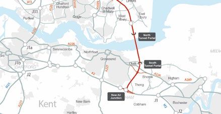
Lower Thames Crossing                                                                                     Case for the Project

                                                   List of figures

                                                                                                              Page number

Figure 3.1    Alternative road crossings.................................................................................. 4
Figure 5.1    Six locations investigated in the 2009 DfT study................................................ 8
Figure 5.2    Shortlisted routes considered in the 2016 study ................................................ 9
Figure 5.3    The preferred route announced in April 2017 .................................................. 10
Figure 6.1    Average hourly flows at Dartford Crossing (Nov 2016–Nov 2017)................... 20

                                                    List of tables

                                                                                                              Page number

Table 5.1    Thames crossing options considered................................................................ 11
Table 6.1    Scheme objectives ............................................................................................ 14
Table 6.2    Journey time savings between locations in the Project area (2026) ................. 20
Table 8.1    European policy requirements .......................................................................... 25
Table 8.2    National policy requirements ............................................................................. 26
Table 8.3    National Policy Statement for National Networks DfT, Jan 2015 ...................... 27
Table 8.4    National Policy Statement for Energy ............................................................... 28
Table 8.5    Local Planning Policy ........................................................................................ 28
Table 8.6    Highway authority transport plans, local policies............................................... 29

HE540039-CJV-GEN-GEN-REP-DCP-00011                                                 Uncontrolled when printed – Copyright © 2018
Date published – 13/09/2018                                   ii            Highways England Company Limited – all rights reserved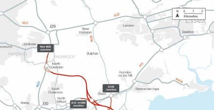
Lower Thames Crossing                                                                  Case for the Project

              Introduction
1.1.1         This document describes why we need the Lower Thames Crossing. It
              discusses the current problems on the strategic road network (SRN) (made up
              of motorways and major ‘A’ roads) and how we have developed our proposal to
              address these problems.
1.1.2         This report forms part of a suite of documents that we have published as part of
              the statutory consultation we are carrying out to support the DCO application
              process.
1.1.3         Statutory consultation is the stage where we present our proposals and listen to
              your feedback to help us develop the Lower Thames Crossing. The next stage
              is applying for a DCO.

 HE540039-CJV-GEN-GEN-REP-DCP-00011                              Uncontrolled when printed – Copyright © 2018
 Date published – 13/09/2018                     1        Highways England Company Limited – all rights reserved
Lower Thames Crossing Case for the Project
About the Lower Thames Crossing
2.1 Background
2.1.1 The Lower Thames Crossing (the ‘Project’) is a proposed new motorway
connecting Kent, Thurrock and Essex through a tunnel beneath the river
Thames. The Project will provide over 90% additional road capacity across the
Thames east of London.
2.1.2 The Project is classified as a Nationally Significant Infrastructure Project (NSIP),
as defined by the Planning Act 2008 and was identified by HM Treasury as one
of the top 40 priority investments in their National Infrastructure Plan 2013.
2.1.3 The Lower Thames Crossing is being developed as part of the Government's
£15 billion Road Investment Strategy over the period 2015-2020.
2.2 The Project
2.2.1 The Lower Thames Crossing will comprise:
approximately 14.5 miles (23km) of new motorway connecting to the
existing road network from the A2/M2 to the M25
two 2.5-mile (4km) tunnels, one southbound and one northbound
three lanes in both directions with a maximum speed limit of 70mph
improvements to the M25, A2 and A13, where the Lower Thames Crossing
connects to the road network
new structures and changes to existing ones (including bridges, buildings,
tunnel entrances, viaducts, and utilities such as electricity pylons) along the
length of the new road
a free-flow charging system, where drivers don’t need to stop but pay
remotely, similar to that at the Dartford Crossing
2.3 Development consent
2.3.1 As the Lower Thames Crossing is an NSIP, we are required to make an
application for a DCO to build, operate and maintain the Project. A DCO is
similar to planning permission but is designed for NSIPs to make the process
clearer, faster and fairer. It does this by allowing many of the consents and
permissions needed for the Project to be considered at the same time.
2.3.2 An Examining Authority, appointed by the Planning Inspectorate on behalf of
the Secretary of State for Transport, has six months to examine the DCO
application. During this process, local authorities, regulatory agencies, local
communities and the public are invited to comment on the application.
2.3.3 After the examination is complete, the Examining Authority has three months to
prepare and publish a report on the application to the Secretary of State for
Transport with its recommendation.
HE540039-CJV-GEN-GEN-REP-DCP-00011 Uncontrolled when printed – Copyright © 2018
Date published – 13/09/2018 2 Highways England Company Limited – all rights reservedLower Thames Crossing Case for the Project
2.3.4 The Secretary of State for Transport then has a further three months to decide
whether to grant or refuse development consent. The Government has
published a National Policy Statement for National Networks (NPSNN), which
provides the framework within which the Examining Authority makes this
recommendation, as required by the Planning Act 2008.
2.3.5 Once the decision has been made, there is a six-week period in which the
decision may be challenged by judicial review.
2.3.6 If the development consent is granted, the DCO will be made by the Secretary
of State and we would start construction in 2021. Contractors will be appointed
to carry out the work as set out in the DCO and the road will be open for traffic
in 2027.
2.3.7 We will seek appropriate consents and comply with relevant legislation for
Project-related activity that does not fall within the DCO scope.
2.4 Highways England
2.4.1 Highways England is responsible for the delivery of the Lower Thames
Crossing.
2.4.2 We are a government-owned company who work with the Department for
Transport (DfT). We operate, maintain and improve England’s motorways and
major A-roads, also known as the strategic road network (SRN). Our aim is to
ensure that road users have safer and more reliable journeys and that
businesses have the effective road links they need to prosper.
2.5 Glossary
2.5.1 You can find explanations of terms and abbreviations used here in the glossary
at the back of this document.
HE540039-CJV-GEN-GEN-REP-DCP-00011 Uncontrolled when printed – Copyright © 2018
Date published – 13/09/2018 3 Highways England Company Limited – all rights reservedLower Thames Crossing Case for the Project
Why we need the Lower Thames Crossing
3.1 Traffic problems east of London
3.1.1 The Dartford Crossing is the only crossing of the River Thames east of London.
Even though it was designed for 135,000 vehicles per day, it carried over
180,000 vehicles on some days in the year to September 2017. Traffic flows
above the design capacity of a road result in congestion and poor reliability,
making the Dartford Crossing one of the least reliable sections of the SRN.
3.1.2 Traffic disruptions at the Dartford Crossing impact communities and businesses
locally and regionally by reducing connectivity and even discouraging travel.
National commercial traffic is also affected as there is no viable alternative to
cross the Thames.
3.1.3 These existing traffic problems highlight the need for an additional crossing of
the Thames east of London.
Alternative routes
3.1.4 Existing alternative road crossings of the Thames, such as the Woolwich Ferry
and the Blackwall Tunnel, are located more than 10 miles from the Dartford
Crossing, as shown in Figure 3.1. Both routes have restrictions over their use.
3.1.5 The closest alternative route for vehicles crossing the Thames east of London is
the Woolwich Ferry which is approximately 10 miles from the Dartford Crossing.
This option does not provide a 24-hour service and offers limited capacity.
3.1.6 The Blackwall Tunnel is next at approximately 15 miles from the Dartford
Crossing but is not suitable for heavy goods vehicles (HGVs) and is already on
a heavily congested road network.
3.1.7 The Silvertown Tunnel, which has recently been granted a DCO, is planned to
open in 2023. This will offer an additional alternative route to cross the Thames
but is not a viable alternative to local and regional traffic across Kent, Thurrock
and Essex due to the distance of the detour, approximately 15 miles from the
Dartford Crossing. The Silvertown Tunnel is intended to reduce congestion at
the nearby Blackwall Tunnel.
Figure 3.1 Alternative road crossings
HE540039-CJV-GEN-GEN-REP-DCP-00011 Uncontrolled when printed – Copyright © 2018
Date published – 13/09/2018 4 Highways England Company Limited – all rights reservedLower Thames Crossing Case for the Project
Traffic forecasts
3.1.8 Traffic modelling indicates that vehicle numbers on the Dartford Crossing will
increase by 17% in the period 2016–2026. This will mean that queuing on the
approaches to the Dartford Crossing, on the SRN and on the local road network
during peak hours will increase. The Dartford area, which is already under
severe traffic pressure, will be the most affected with heavy traffic extending
beyond current peak hours.
Environmental issues
3.1.9 When congestion and closures occur at the Dartford Crossing, the quality of the
environment is heavily impacted by the queuing traffic, with local communities
being exposed to high levels of air pollution and noise. In line with the traffic
forecasting, these environmental issues are expected to increase.
Incidents
3.1.10 In the period from September 2015–August 2016, over 1,500 incidents (during
weekday charging hours) were recorded at the Dartford Crossing that resulted
in single or multi-lane closures which had the effect of closing a lane for over 15
minutes. Over 400 of these incidents resulted in closures which caused delays
equivalent to closing a lane for over 60 minutes. Depending on the location,
timing and scale of the incident, it can take up to 5 hours for queues to clear
and for journeys to return to average times.
Free-flow charging
3.1.11 The removal of the barriers and introduction of free-flow charging technology at
the Dartford Crossing in November 2014 (ie, the ‘Dart Charge’ scheme)
improved traffic flow and journey times but, as it was designed as a medium-
term solution, did not fully address the need for increased capacity. With traffic
volumes using the Dartford Crossing forecast to increase, the Dart Charge
scheme will only relieve congestion in the medium term and major
improvements are needed to provide a long-term solution.
Hazardous and oversized transportation
3.1.12 Apart from under exceptional circumstances, Dartford Crossing northbound
traffic uses the two tunnels, while southbound traffic uses the bridge. However,
for safety reasons, general traffic travelling north is held back when certain
hazardous loads have to be escorted through. At peak periods this can increase
congestion which can take a long time to clear.
3.1.13 Data from 2016 shows that over 2,000 escorts take place every month, with
convoys of restricted vehicles dispatched approximately every 15 minutes
during weekday peak and inter-peak periods. Each escort resulted in
approximately 90 seconds of closure on average which equates to 5-7 minutes
of closures each hour, leading to a loss of between 8-12% of capacity. The
process of removing escorted vehicles from general traffic lanes can also result
in additional disruptions and loss of capacity.
HE540039-CJV-GEN-GEN-REP-DCP-00011 Uncontrolled when printed – Copyright © 2018
Date published – 13/09/2018 5 Highways England Company Limited – all rights reservedLower Thames Crossing Case for the Project
Summary
3.1.14 Current and forecast conditions at the Dartford Crossing highlight the significant
traffic and environmental issues in the surrounding areas. These conditions
create a need for an additional crossing to reduce these adverse effects.
HE540039-CJV-GEN-GEN-REP-DCP-00011 Uncontrolled when printed – Copyright © 2018
Date published – 13/09/2018 6 Highways England Company Limited – all rights reservedLower Thames Crossing Case for the Project
Benefits of a new crossing
4.1 Quicker, more reliable journeys
4.1.1 The new road network, with a tunnel beneath the Thames connecting
Gravesham south of the river and Thurrock north of the river, will increase road
capacity across the Thames east of London by over 90%. It will link with the A2
in the south and the M25 in the north.
4.1.2 The new route will have a maximum
speed limit of 70mph. It will provide At approximately 2.5 miles long,
quicker, more reliable journeys locally the tunnel will be the longest
and regionally between Kent, road tunnel in the UK and, at
Thurrock and Essex, as well as 16m, one of the largest tunnels
nationally. This will help meet the
by diameter in the world
demands of future traffic growth east
of London.
4.2 Connecting communities and business
4.2.1 As the volume of traffic crossing the Thames Estuary east of London has
increased, it has resulted in slow-moving traffic and long and uncertain journey
times. As such, it has been difficult to build strong connections between
communities and businesses in Kent, Thurrock and Essex.
4.2.2 The new route will create better access on both sides of the river. This will
improve journey times and reliability for communities and businesses, whether
travelling short distances across the Thames to visit family or looking for better
access to job or business opportunities.
4.3 Economy
4.3.1 The Lower Thames Crossing will provide access for local and regional
communities to jobs, leisure and retail, benefiting development and economic
growth on both sides of the Thames.
4.3.2 The crossing will also improve journey times for national commercial traffic
north and south of the river. It will serve south London, Kent and Sussex, as
well as continental Europe via the South East and East of England’s ports and
the Channel Tunnel.
4.3.3 The region's ports, including Dover, Folkestone, Tilbury and London Gateway,
are the country's commercial gateways to the world. They will benefit from
quicker and more reliable access to key markets, resources and employees.
4.4 Environment
4.4.1 The Lower Thames Crossing will help reduce congestion in the Dartford area.
This will decrease forecasted high levels of pollution, benefiting local
communities.
HE540039-CJV-GEN-GEN-REP-DCP-00011 Uncontrolled when printed – Copyright © 2018
Date published – 13/09/2018 7 Highways England Company Limited – all rights reservedLower Thames Crossing Case for the Project
How the route was chosen
5.1.1 A structured process has been followed by DfT and Highways England to
identify and assess potential options for the Project. A summary of the identified
locations and the timelines associated with the assessment of each is provided
in Table 5.1.
5.1.2 DfT carried out a study in 2009 that reviewed six potential crossing locations,
identified as A, B, C, D1, D2 and E (Figure 5.1). This study found that the two
location D options and the location E option would not relieve the congested
Dartford Crossing, and so were not selected for further assessment. Further
work was carried out by DfT in 2013 to consider three of the potential crossing
locations in more detail, A, B and C. Following public consultation, two crossing
locations, A and C, were taken forward for further consideration. Option B was
not taken forward due to conflict with the development of Ebbsfleet Garden City
and the Swanscombe Peninsula. As a result, no viable solutions could be
developed at this location.
Figure 5.1 Six locations investigated in the 2009 DfT study
HE540039-CJV-GEN-GEN-REP-DCP-00011 Uncontrolled when printed – Copyright © 2018
Date published – 13/09/2018 8 Highways England Company Limited – all rights reservedLower Thames Crossing Case for the Project
5.1.3 We then carried out a detailed option identification and route selection process
at the two crossing locations. Several options were considered at location A and
location C. A potential modification was considered to location C, which
included changes to the roads connecting the M20 and M2, known as C variant.
5.1.4 Location A was assessed and found not to meet the scheme objectives (see
section 6). Assessment of the C variant options determined that they did not
help to transfer traffic from the existing Dartford Crossing on to the new route at
location C. It also had substantial impacts on the Kent Downs Area of
Outstanding Natural Beauty (AONB). As a result, the C variant options were not
considered further.
5.1.5 We held a non-statutory public consultation in 2016 which proposed a crossing
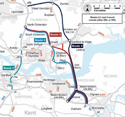
at location C and presented three route options. These were identified as routes
2, 3 and 4. Each option included two different routes south of the Thames: the
Western Southern Link and the Eastern Southern Link (see Figure 5.2).
5.1.6 A further appraisal was undertaken, considering the findings of the public
consultation, and this resulted in the selection of the preferred route announced
in April 2017.
Figure 5.2 Shortlisted routes considered in the 2016 study
HE540039-CJV-GEN-GEN-REP-DCP-00011 Uncontrolled when printed – Copyright © 2018
Date published – 13/09/2018 9 Highways England Company Limited – all rights reservedLower Thames Crossing Case for the Project
5.1.7 The preferred route announced by the Secretary of State was route 3 north of
the Thames, with a tunnel crossing under the Thames east of Gravesend and
Tilbury and a new road south of the Thames which will join the A2 east of
Gravesend (the Western Southern Link – see Figure 5.3).
5.1.8 The preferred route was selected based on the information obtained before,
during and after the public consultation. This route met the scheme objectives
(see section 6), while having the lowest impact on several environmentally
sensitive areas. These included the Thames Estuary and Marshes Special
Protection Area (SPA) and Ramsar site, ancient woodlands in the area, and the
Kent Downs AONB, as well as on the communities close to the route. The
assessment that resulted in the identification of the preferred route is presented
in the Post-Consultation Scheme Assessment Report (Highways England,
2017).
Figure 5.3 The preferred route announced in April 2017
HE540039-CJV-GEN-GEN-REP-DCP-00011 Uncontrolled when printed – Copyright © 2018
Date published – 13/09/2018 10 Highways England Company Limited – all rights reservedLower Thames Crossing Case for the Project
5.1.9 Following the Secretary of State for Transport’s announcement of the preferred
route in April 2017, we have continued to develop our proposals and now have
a more detailed understanding which has helped us to develop the Project we
are presenting in this consultation.
5.1.10 We have reassessed the previous options appraisal process, conducting further
studies where necessary. This assessment has confirmed the selection of the
preferred route, taking account of changes made to the proposals for the
Project following the announcement in April 2017. Information on changes to
the Project and this reassessment is provided in the Approach to Design,
Construction and Operation report.
5.1.11 The further work we have carried out to develop our proposals has
strengthened the overall benefits delivered by this route.
Table 5.1 Thames crossing options considered
Location Key dates Assessment
A – Additional • 2009 – Identified in the study Location A was identified as a potential
capacity at the carried out on behalf of DfT option in public consultation undertaken in
existing Dartford Dartford River Crossing Study 2013. It was then assessed in further detail
Crossing Final Report, 2009, DfT but was considered not to meet the scheme
• 2013 – Appraised and objectives. Public consultation in 2016
presented for public invited feedback on our proposal to locate
consultation by DfT the crossing at location C. Further appraisal
of location A took place following conclusion
• Options for a New Lower of that consultation.
Thames Crossing, 2013, DfT
Location A could not be developed into a
• 2016 – Appraised in further solution that met the scheme objectives.
detail and considered not to The identified solutions were not viable
meet scheme objectives because they failed to relieve the
• Scheme Assessment Report, congestion on the approaches to the
2016, Highways England Dartford Crossing as they did not provide a
• Lower Thames Crossing Route suitable alternative route for traffic travelling
Consultation 2016 along the A2 and A13. Solutions that relied
on the connection at junction 2 and junction
• 2017 – Reappraised and not 30 of the M25 failed to relieve congestion at
selected as the preferred route or on the approaches to these key junctions.
• Post Consultation Scheme Solutions that did not include these
Assessment Report, 2017, connections failed to provide the necessary
Highways England relief to the Dartford Crossing itself.
B – Swanscombe • 2009 – Identified in the study Location B was presented at public
Peninsula Link to carried out on behalf of DfT consultation in 2013. Following the
the A1089 Dartford River Crossing Study consultation, this location was not taken
Final Report, 2009, DfT forward for further assessment. The
• 2013 – Appraised and taken to identified solutions conflict with the local
public consultation by DfT development plans, particularly including
Ebbsfleet Garden City and the
• Options for a New Lower Swanscombe Peninsula. As a result, no
Thames Crossing, 2013, DfT viable solutions could be developed at this
• 2013 – The decision was location.
made not to carry out further
work on this location
HE540039-CJV-GEN-GEN-REP-DCP-00011 Uncontrolled when printed – Copyright © 2018
Date published – 13/09/2018 11 Highways England Company Limited – all rights reservedLower Thames Crossing Case for the Project
Location Key dates Assessment
• Options for a New Lower
Thames Crossing –
Consultation Response
Summary, 2013, DfT
C – East of • 2009 – Identified in the study Following early studies and the public
Gravesend and carried out on behalf of DfT consultation in 2013, location C was
Link to the M20 Dartford River Crossing Study developed into a series of potential
Final Report, 2009, DfT solutions which were appraised in detail in
• 2013 – Appraised and taken to the 2016 assessment.
public consultation by DfT Three routes to the north of the Thames,
• Options for a New Lower identified as routes 2, 3 and 4, and two
Thames Crossing, 2013, DfT routes to the south, identified as the Eastern
Southern Link and Western Southern Link,
• 2016 – Multiple options were were considered as able to meet the
developed, and three different scheme objectives. Each of these potential
options were taken forward to routes would be connected across the
public consultation Thames by a tunnel to minimise impacts on
• Scheme Assessment Report, the local environmentally sensitive areas.
2016, Highways England These routes were presented at public
• Lower Thames Crossing Route consultation in 2016. Information gathered
Consultation 2016 during and following the consultation was
then used to reappraise each of the routes.
• 2017 – Reappraised following Following this appraisal, it was identified
consultation and the preferred that route 3, with the Western Southern Link
route was identified at location would have the lowest impact on several
C environmentally sensitive areas, particularly
Post Consultation Scheme on the Thames Estuary and Marshes SPA
Assessment Report, 2017, and Ramsar site, the ancient woodland and
Highways England the Kent Downs AONB, as well as on the
communities close to the route.
On 12 April 2017 the Secretary of State for
Transport confirmed the preferred route as
follows:
• a tunnel crossing under the Thames
east of Gravesend and Tilbury
(location C)
• a new road north of the Thames which
will join the M25 between junctions 29
and 30 (route 3)
• a new road south of the river which will
join the A2 east of Gravesend (the
Western Southern Link)
D1 – M2 Link to 2009 – Identified in the study The two alternative location D options were
A130 via carried out on behalf of DfT. The not taken forward following the first stage of
Cliffe/Pitsea decision was made not to carry out location identification and appraisal. The
further work on these locations location D options were found to be located
D2 – M2 to A130
Dartford River Crossing Study Final too far to the east and modelling showed
via Canvey Island
Report, 2009, DfT that they failed to provide the necessary
relief to the congested Dartford Crossing as
they did not support the key traffic
movements across the Thames.
HE540039-CJV-GEN-GEN-REP-DCP-00011 Uncontrolled when printed – Copyright © 2018
Date published – 13/09/2018 12 Highways England Company Limited – all rights reservedLower Thames Crossing Case for the Project
Location Key dates Assessment
As a result, no viable solutions could be
developed at this location that would meet
the scheme objectives.
E – Isle of Grain 2009 – Identified in the study As with the two alternative location D
Link to East of carried out on behalf of DfT. The options, location E was not taken forward
Southend decision was made not to carry out following the first stage of location
further work on this location identification and appraisal. Like the D
Dartford River Crossing Study Final options, location E was located too far to the
Report, 2009, DfT east and did not provide the necessary relief
to the congested Dartford Crossing as it did
not provide for the key traffic movements
across the Thames. As a result, no viable
solutions could be developed at this location
that would meet the scheme objectives.
HE540039-CJV-GEN-GEN-REP-DCP-00011 Uncontrolled when printed – Copyright © 2018
Date published – 13/09/2018 13 Highways England Company Limited – all rights reservedLower Thames Crossing Case for the Project
Our objectives
6.1 Introduction
6.1.1 To provide specific focus for the Project, several key objectives were agreed by
DfT and Highways England, which cover strategy, transport, charging and the
environment.
6.1.2 They comprise three principal categories: economic, community and
environmental, and transport (see Table 6.1).
Table 6.1 Scheme objectives
Scheme objectives
Economic 1. To support sustainable local development and regional
economic growth in the medium to long term
2. To be affordable to government and users
3. To achieve value for money
Community & 4. To minimise adverse impacts on health and the
environment environment
Transport 5. To relieve the congested Dartford Crossing and
approach roads and improve their performance by
providing free-flowing north-south capacity
6. To improve the resilience of the Thames crossings and
the major road network
7. To improve safety
6.2 How we achieve these objectives
6.2.1 The following section sets out each of these objectives and discusses how the
Project meets each of them.
Objective 1: To support sustainable local development and
regional economic growth in the medium to long term
6.2.2 The Lower Thames Crossing will reduce journey times and improve journey
reliability between Kent, Thurrock and Essex. This will lead to a substantial
increase in accessibility for local and regional communities and businesses,
providing the potential for improved productivity and economic growth through
better connectivity.
6.2.3 The new route will be an important part of the SRN, which provides critical local,
regional and national links between communities and business and connects
our major ports, airports and rail terminals. A well-functioning SRN is essential
for better, more reliable journeys, enabling the movement of goods to support
national and regional economies. This drives prosperity by supporting new and
existing development, encouraging trade and attracting investment.
6.2.4 The Lower Thames Crossing not only provides over 90% additional cross-river
road capacity, it enables more reliable journeys; something which is key in
freight delivery regionally and nationally.
HE540039-CJV-GEN-GEN-REP-DCP-00011 Uncontrolled when printed – Copyright © 2018
Date published – 13/09/2018 14 Highways England Company Limited – all rights reservedLower Thames Crossing Case for the Project
Local growth
6.2.5 Currently, the Dartford Crossing is the only road crossing of the Thames east of
London and is subject to severe congestion. This affects strategic and local
road users, which constrains economic growth in the region.
6.2.6 Poor connectivity severs local labour and product markets, impacting
economies in the surrounding area. Currently, only 4% of traffic at the Dartford
Crossing starts and ends in the local area, which includes Purfleet, Grays,
Dartford and Gravesend. The additional connectivity offered by the Lower
Thames Crossing will improve the ability for local traffic to cross the Thames.
6.2.7 Key industries in the local authority areas near to the Project, such as
distribution and transportation, rely on good connectivity. Local authority plans
support business and employment growth in these sectors:
Gravesham Borough Council aims to support the creation of 4,600 new jobs
in these sectors between 2014 and 2028 (Gravesham Local Plan Core
Strategy, adopted September 2014).
Thurrock Council also recognises the importance of these sectors, having
made land allocations to support their continued growth (Thurrock Core
Strategy and Policies for the Management of Development (as amended),
adopted January 2015).
6.2.8 The Lower Thames Crossing will relieve congestion on both sides of the
Thames east of London, opening up opportunities for local economic growth.
Regional development
6.2.9 The Lower Thames Crossing will support business growth across the region. A
report prepared for Kent County Council and Essex County Council,
Assessment of Lower Thames Crossing Capacity (November 2008), stated:
“One of the main planning objectives for south Essex and north Kent is to
enable development in order to regenerate the areas. A new crossing can help
achieve these objectives and indeed can also open up new areas thought
inaccessible for new development.”
“The economic vitality of the areas either side of the Thames are already
affected by their coastal locations and would benefit from greater cross-Thames
capacity and journey reliability.”
6.2.10 The Federation of Small Businesses surveyed their members in June 2018 on
their views of the proposed Lower Thames Crossing. The findings were as
follows:
63% reported transport congestion as the major challenge to their business
82% support the Lower Thames Crossing
50% think the Lower Thames Crossing will help their business grow by
providing better access to new customers
HE540039-CJV-GEN-GEN-REP-DCP-00011 Uncontrolled when printed – Copyright © 2018
Date published – 13/09/2018 15 Highways England Company Limited – all rights reservedLower Thames Crossing Case for the Project
6.2.11 A range of small-to-medium enterprises and large businesses across the region
have voiced their support for the scheme.
“I have absolutely no doubt that the Lower Thames Crossing will make a
massive difference to this business. It’s going to be a big big big advantage to
us.” Glyn Jones, Chief Operating Officer of Stobart Aviation, which owns
Southend Airport.
“To enable us to have growth, we need the proper transport links. We need the
Lower Thames Crossing now.” Denise Rossiter, Chief Executive, Essex
Chambers of Commerce.
“Once the new crossing is open, our members will be able to plan with much
more certainty, which will open up much more opportunities regionally and also
nationally.” Jo James, Chief Executive, Kent Invicta Chamber of Commerce.
Ports
6.2.12 The crossing will provide improved accessibility to international ports in the
region. The Economic Connectivity Review by Transport for the South East was
published as a draft for consultation in May 2018. This study identifies the A2-
M2 Chatham-Dover as a key transport corridor that provides connections to the
London Ports and Port of Dover.
6.2.13 The crossing will open up a more reliable
route across the Thames for some of the The Lower Thames Crossing
most important UK ports, servicing the will connect communities in
local and national import and export Kent, Thurrock and Essex and
markets. For example, the Port of Tilbury
is a key centre of logistics and provide better access to jobs,
employment, with the potential for an leisure and retail facilities on
additional 2,700 jobs within the existing both sides of the river
port and the proposed expansion at
Tilbury2 (Outline Business Case, Port of
Tilbury London, 2017). London Gateway has development plans with the
potential to create 11,000 to 13,000 jobs (Thurrock Core Strategy and Policies
for the Management of Development (as amended), adopted January 2015).
Objective 2: To be affordable to government and users
6.2.14 The current total estimated cost of developing and constructing the Project is
between £5.3–£6.8 billion.
6.2.15 Making the right decision on financial and delivery models is vital in driving
value for taxpayer money and for making the Project affordable to the
government. It is proposed that:
the tunnel (ie, estuarial crossing) is publicly funded
the approach roads, including the junctions, are privately financed
6.2.16 The use of private finance will provide greater certainty with respect to cost and
timeframes and bring affordability advantages as payment can be deferred until
the Project is operational and can be spread out over 25–30 years.
HE540039-CJV-GEN-GEN-REP-DCP-00011 Uncontrolled when printed – Copyright © 2018
Date published – 13/09/2018 16 Highways England Company Limited – all rights reservedLower Thames Crossing Case for the Project
6.2.17 Given the scale of capital expenditure and the capacity of the private finance
market, the use of private finance is not considered to be efficient for the
delivery of the tunnel package.
6.2.18 We also expect to introduce road user charging to the tunnel. The primary
objective for road user charging is to manage traffic using the new crossing and
the connecting SRN. Although the road user charges will need to be set at a
level that enables us to meet our traffic management objectives, affordability to
users will also be a key consideration. See section 7 for more information on
charging.
Objective 3: To achieve value for money
6.2.19 The Government describes value for money as ‘using public resources in a way
that creates and maximises public value’ and this is defined in DfT’s Value for
Money Framework. For road projects such as the Lower Thames Crossing, the
Web-based Transport Analysis Guidance (WebTAG) framework provides
guidance on assessing benefits and costs.
6.2.20 A transport project’s value for money is defined in part by its Benefit Cost Ratio
(BCR). A BCR indicates how much benefit a project would provide on a cost
basis. DfT uses six value for money categories, ranging from Very High to Very
Poor.
6.2.21 Since the previous value for money assessment was undertaken by the Project,
DfT has made some key changes to the WebTAG framework. Therefore, any
value for money assessment produced using the current WebTAG framework is
not directly comparable to previous assessments undertaken for the Project at
earlier stages.
6.2.22 We are continuing to appraise the Project to assess value for money using the
Lower Thames Area Model1, incorporating both the developments to the Project
since the announcement of the preferred route and the recent updates to the
WebTAG framework. We are confident the Lower Thames Crossing will deliver
value for money in line with the Government’s framework. At the current stage
of development our initial assessment suggests the Project achieving Medium
value for money2. The most significant monetary benefits from the Project are
expected to be the time savings that road users experience when making
journeys and the productivity benefits that businesses experience from
improved connectivity and journey time savings.
6.2.23 We are continuing to develop the BCR for the Lower Thames Crossing as part
of our Outline Business Case. This is scheduled for completion ahead of our
DCO submission.
1 The Lower Thames Area Model is a strategic highway model produced by Highways England to assess the
impact of the Project on the highway network. It also provides traffic data for use in the environmental, social
and economic assessment of the Project.
2Medium value for money generally has a BCR between 1.5 and 2. This indicates that for every pound spent
building the Lower Thames Crossing, the Project will return between £1.50 and £2 in benefits.
HE540039-CJV-GEN-GEN-REP-DCP-00011 Uncontrolled when printed – Copyright © 2018
Date published – 13/09/2018 17 Highways England Company Limited – all rights reservedLower Thames Crossing Case for the Project
Objective 4: To minimise adverse impacts on health and the
environment
6.2.24 We intend to develop a new road crossing for the lower Thames Estuary and
associated road network that is designed to work with its surroundings.
Environmental sustainable development is at the centre of all our activities and
the decisions we make.
6.2.25 The options studies and consultations carried out before the selection of the
preferred route for the Project considered the impacts of the options on people
and the environment. The preferred route was recommended as the option that
best met scheme objectives, including minimising adverse impacts on health
and the environment.
6.2.26 A tunnel under the river, rather than a bridge crossing, provides the best
opportunity to avoid adverse impacts on sensitive and valuable habitats on and
adjacent to the Thames, such as the Thames Estuary and Marshes Ramsar
and Special Protection Area sites. This option minimises any potential
disturbance, both during construction and operation, of the river and any
associated indirect impacts on the adjacent international and European
designations. The Project route option chosen was also considered to have the
least adverse effect on environmentally sensitive areas, particularly on ancient
woodland and the Kent Downs AONB, and on the communities adjacent to the
Project route, compared to other options considered.
6.2.27 Since the preferred route announcement, the design has been further refined,
considering the findings of ongoing environmental studies and surveys, and
community and stakeholder feedback in order to minimise adverse effects
where practicable. For example, some stretches of the proposed road have
been lowered in the landscape, and the Lower Thames Crossing junction with
the M25 has been revised to cross under the M25 rather than over it, which
reduces the potential visual impact. The location of the south portal has also
been adjusted, which reduces the potential for impacts on the Thames Estuary
and Marshes Ramsar site, which is protected for nature conservation.
6.2.28 We recognise that the Project will have an adverse effect on the environment
elsewhere, and we are carrying out an Environmental Impact Assessment and
Health Impact Assessment to understand the potential effects of the Project on
people and the environment. The Project is still being refined, so where adverse
effects are currently anticipated, for example in the AONB, we are seeking ways
to avoid or reduce these through further development of the design.
6.2.29 Where negative effects on the environment cannot be avoided, measures to
reduce or mitigate these will be developed where practicable, including the use
of noise barriers, landscape planting and creation of new habitats.
6.2.30 Initial indications are that, while there will be some adverse effects near the new
alignment, such as in Orsett and Grays, the present environment near the
Dartford Crossing will be improved because of the Project. The Lower Thames
Crossing will reduce the severance and pollution currently caused by the
existing congested approaches, with benefits to air quality in these areas.
6.2.31 As well as the effects after the Project opens, we are also considering the
potential impacts during the construction of the Project. A Code of Construction
HE540039-CJV-GEN-GEN-REP-DCP-00011 Uncontrolled when printed – Copyright © 2018
Date published – 13/09/2018 18 Highways England Company Limited – all rights reservedLower Thames Crossing Case for the Project
Practice will be developed, which will set out the measures that the Project will
implement to reduce disruption and environmental effects during construction.
This will include industry standard practice and control measures for
environmental impacts arising during construction, such as the control of dust
and the approach to waste management on site.
Objective 5: To relieve the congested Dartford Crossing and
approach roads and improve their performance by providing
free-flowing north-south capacity
6.2.32 Traffic at the Dartford Crossing has increased significantly over time. On some
days traffic using the Dartford Crossing exceeds 180,000 vehicles which is
some 45,000 vehicles more than it was designed to take. This volume of traffic
causes congestion and can reduce traffic in peak periods to a standstill.
6.2.33 Traffic volumes across the Dartford Crossing between peak periods and at the
weekend do not drop as seen elsewhere on the SRN due to limited alternative
routes across the Thames east of London (see Figure 6.1). Because of these
high volumes, speeds are reduced and there is an increased risk of incidents
which leads to further congestion.
6.2.34 The Lower Thames Crossing has
been designed to provide a free-flow, The Lower Thames Crossing will
connection between the A2 and M25 reduce traffic flows at the Dartford
with a maximum speed of 70mph. Crossing, variability in journey
This includes free-flow junctions at times, and day-to-day delays and
either end as well as free-flow user
help relieve congestion
charging facilities, as is the case at
the Dartford Crossing.
6.2.35 Government strategies, including DfT’s Road Investment Strategy for the
2015/2016 – 2016/2020 Road Period and the HM Treasury National
Infrastructure Delivery Plan 2016 – 2021, recognise that congestion is a major
issue on the road network and in certain places the SRN has already reached
capacity. The Lower Thames Crossing has been identified within these
strategies as a way to tackle congestion at the Dartford Crossing.
6.2.36 As well as affecting journeys crossing the Thames, this congestion affects
journeys on local roads around the Dartford Crossing due to busy roads and
backed up traffic. Local people’s daily routines are impacted, leading to wasted
time for people and industry, and affecting economic productivity.
6.2.37 The average daily traffic flow using the Dartford Crossing without the Lower
Thames Crossing is predicted to increase by 17% in the period 2016–2026.
This will lead to increased congestion at the Dartford Crossing, on key approach
roads such as the A2, M20, A13 and A127, and on the local road network in
Dartford and Thurrock.
6.2.38 The Lower Thames Crossing will reduce congestion on key approach roads to
the existing Dartford Crossing, including the A13 approach to junction 30 of the
M25 and the A2 approach to junction 2. It will provide a quicker, more reliable
alternative for those wishing to travel across the Thames east of London.
HE540039-CJV-GEN-GEN-REP-DCP-00011 Uncontrolled when printed – Copyright © 2018
Date published – 13/09/2018 19 Highways England Company Limited – all rights reservedLower Thames Crossing Case for the Project
Figure 6.1 Average hourly flows at Dartford Crossing: Nov 2016–Nov 2017
6,000
5,000
Average Hourly Flow
4,000
3,000
2,000
1,000
-
0-1
1-2
2-3
3-4
4-5
5-6
6-7
7-8
8-9
9-10
10-11
11-12
12-13
13-14
14-15
15-16
16-17
17-18
18-19
19-20
20-21
21-22
22-23
23-24
Hour
Mon Tue Wed Thu Fri Sat Sun
6.2.39 Before opening the Lower Thames Crossing, the average daily traffic flow using
the Dartford Crossing is forecast to rise to 166,000 vehicles. This is forecast to
reduce to 129,000 when the Project opens.
6.2.40 Table 6.2 shows how average minimum and maximum journey times during the
AM and PM peaks will change in the Project area once the Lower Thames
Crossing is operational (based on 2026, a representative opening year covering
a range between 2025 and 2027). These locations have been chosen to give a
wide cross-section of the area but only represent a few possible journeys. For
more detail on journey time savings you can refer to the Traffic Forecasting
Report (available on the Highways England webpage) which contains many
more examples of journeys.
Table 6.2 Journey time savings between locations in the Project area
(2026)
Journey Minimum time savings Maximum time savings
(minutes) (minutes)
Cheshunt to/from 2.5 4.8
Maidstone
Basildon to/from 17.0 23.0
Rainham
Romford to/from Bexley 1.1 4.6
Godstone to/from 1.6 6.5
Brentwood
6.2.41 The new crossing will give vehicles carrying hazardous materials an alternative
route across the Thames without the need for escort, therefore potentially
further alleviating congestion.
HE540039-CJV-GEN-GEN-REP-DCP-00011 Uncontrolled when printed – Copyright © 2018
Date published – 13/09/2018 20 Highways England Company Limited – all rights reservedLower Thames Crossing Case for the Project
Objective 6: To improve resilience of the Thames crossings and
the major road network
Pressures on resilience of SRN east of London
6.2.42 As the Dartford Crossing is the only road crossing of the Thames east of
London, the SRN can be severely impacted by incident-related and other
closures. As discussed previously, such closures can take up to five hours for
queues to clear and for journeys to return to average times, depending on the
location, timing and scale of the incident.
6.2.43 Unplanned closures also arise due to high winds on the southbound bridge.
6.2.44 As outlined previously, in the period from September 2015–August 2016, over
1,500 incidents (during weekday charging hours) were recorded at the Dartford
Crossing that resulted in single or multi-lane closures which had the effect of
closing a lane for over 15 minutes. Over 400 of these incidents resulted in
closures which caused delays equivalent to closing a lane for over 60 minutes.
There are approximately 1.6 incidents of this magnitude every weekday during
charging hours.
6.2.45 Delays are also associated with traffic management activities in the northbound
direction, including the safe escort of vehicles carrying hazardous materials and
other restricted vehicles including oversized and abnormal loads. In addition,
the tunnels are regularly closed outside peak times to allow for routine
maintenance.
6.2.46 As well as affecting immediate approach roads to the crossing, incidents and
accidents and the related congestion they cause can lead to knock-on effects
on the local road network, including local town centres, and the roads which
connect between Dartford, Greenhithe and Bluewater.
Alternative routes
6.2.47 When incidents and congestion occur at the Dartford Crossing, there are limited
alternative routes for traffic to cross the Thames. The Woolwich Ferry is
approximately 10 miles from the crossing by road and offers restricted capacity
as it only operates 14 hours a day, has size limitations and cannot carry
vehicles with hazardous loads.
6.2.48 The Blackwall Tunnel is 15 miles from the crossing by road and prohibits
vehicles that carry hazardous materials. Routes around the Blackwall Tunnel
experience severe congestion during peak periods.
6.2.49 The Silvertown Tunnel is planned to become operational in 2023. This will offer
an additional alternative to crossing the Thames east of London but will require
a detour of approximately 15 miles through London and so will not represent a
viable route for users unable to cross at Dartford.
6.2.50 There are also additional crossings of the Thames through central London, but
these require detours through busy London roads. Additionally, many of the
London river crossings are located within the London congestion charge zone
and attract an additional charge. Many of these also fall within the existing Low
Emission Zone, T-Charge zone, and the planned Ultra-Low Emission Zone and
its extension.
HE540039-CJV-GEN-GEN-REP-DCP-00011 Uncontrolled when printed – Copyright © 2018
Date published – 13/09/2018 21 Highways England Company Limited – all rights reservedLower Thames Crossing Case for the Project
6.2.51 Larger vehicles or those carrying hazardous materials that need an alternative
route to the Dartford Crossing have to detour via the M25 (ie, via Heathrow).
This can be up to an additional 100 miles.
Lower Thames Crossing solution
6.2.52 The Lower Thames Crossing will provide an alternative route east of the
Dartford Crossing for local, regional and national traffic. The additional crossing
will allow for more convenient diversionary routes during any closure of the
Dartford Crossing. It will provide effective incident management during closures
at the Dartford Crossing, leading to
faster recovery times. This will
lessen the impact of incidents on The Lower Thames Crossing will
local communities by reducing the provide quicker, more reliable
overflow of traffic onto the local journeys locally, regionally and
network and decreasing the amount nationally
of time that the network suffers
from incident-related congestion.
6.2.53 For example, in the event of a closure, strategic electronic message signing will
direct traffic away from the Dartford Crossing. This will improve the resilience of
the SRN and allow it to continue to support freight, commuter, leisure and
business travel across south-east England.
Objective 7: To improve safety
6.2.54 Building the Project and providing additional capacity across the Thames will
result in more traffic movements and faster travel than is currently possible on
the SRN in this area.
6.2.55 We are designing a Project with safety at its heart, incorporating the latest
operational safety technology throughout. For example, monitoring equipment
works with highly visible messaging to relay the most up-to-date traffic
information. Clear motorway messaging can also help to reduce confusion at
junctions and, therefore, the number of incidents.
6.2.56 Inside the tunnel, safety features will include monitoring equipment to detect
broken-down vehicles, onsite vehicle recovery, and access routes at both
entrances for the emergency services. Providing an alternative route for HGVs
away from the Dartford Crossing and for lorries carrying dangerous goods to
pass through the new tunnel will also significantly improve safety and reduce
incidents. The tunnel will incorporate the latest fire and safety technology.
6.2.57 The Lower Thames Crossing will make provision for a Rest and Service Area
(RaSA) for road users along its route. RaSAs provide an important road safety
function by allowing road users to stop and take a break during their journey.
The RaSA will provide parking for cars, HGVs and coaches as well as the
potential for fuel, food, drink and bathroom facilities. The RaSA will also provide
charging points for electric vehicles at designated parking bays.
6.2.58 We are passionate about improving road safety and we view the safety of road
users and road workers as paramount. Therefore, our aim is that no-one should
be harmed who builds, operates, maintains and uses the new road network.
HE540039-CJV-GEN-GEN-REP-DCP-00011 Uncontrolled when printed – Copyright © 2018
Date published – 13/09/2018 22 Highways England Company Limited – all rights reservedYou can also read