Thames river basin district Flood Risk Management Plan 2015 to 2021 Habitats Regulation Assessment - March 2016 - Gov.uk
←
→
Page content transcription
If your browser does not render page correctly, please read the page content below
Thames river basin district
Flood Risk Management Plan 2015
to 2021
Habitats Regulation Assessment

March 2016

                  1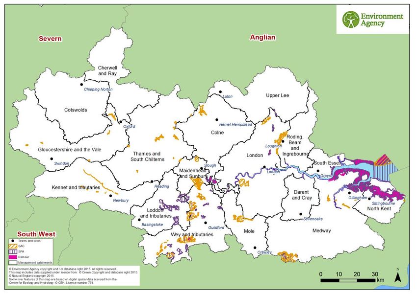
Executive summary
The Flood Risk Management Plan (FRMP) for the Thames River Basin District (RBD)
provides an overview of the range of flood risks from different sources across the 17
catchments of the RBD and more specifically from local flood sources in the 2 Flood Risk
Areas (FRAs) of London and Medway. The RBD catchments are defined in the River Basin
Management Plan (RBMP) and based on the natural configuration of bodies of water (rivers,
estuaries, lakes etc.).

The 2 FRAs were identified as having higher local flood risk by the Preliminary Flood Risk
Assessments. The FRMP provides a range of objectives and programmes of measures
identified to address these risks from all flood sources. These are drawn from the many risk
management authority plans already in place but also include a range of further strategic
developments for the FRMP ‘cycle’ period of 2015 to 2021. The range of measures in the
Thames RBD FRMP are reported under the following types of flood management action:

Types of flood management measures                                                     % of
                                                                                   measures
Prevention – e.g. land use policy, relocating people at risk etc.                      39%
Protection – e.g. various forms of asset or property-based protection                  22%
Preparedness – e.g. awareness raising, forecasting and warnings                        31%
Recovery and review – e.g. the ‘after care’ from flood events                           3%
Other – any actions not able to be categorised yet                                      5%

The purpose of the HRA is to report on the likely effects of the FRMP on the network of sites
that are internationally designated for protection (European sites) and the HRA has been
carried out at the level of detail of the plan. Many measures do not have any expected
physical effects on the ground and have been screened out of consideration including most
of the measures under the categories of Prevention, Preparedness, Recovery and Review.
Others that may have effects but are in catchments that do not have any designated
European sites have also been screened out of consideration.

Risk management authorities (RMAs) have for a long time been addressing the range of
flood risks through a range of plans and actions. Much of the Thames RBD FRMP presents
measures that are ongoing from existing plans which have already been subject to HRA.
RMAs have considered the effects of these existing plan measures on European Sites in
published HRAs where required. These measures, their effects and agreed actions to
mitigate the effects have been summarised under relevant RBD catchments and FRAs.
Where RMAs have identified new flood risk management priorities for the next FRMP cycle
period between 2015 and 2021, then the measures to implement these have been
considered alongside existing plan measures in this HRA.

The following summarises the numbers of measures that the HRA has considered: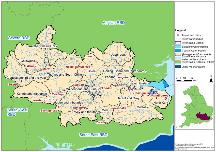
FRMP RMA plans                          Screened out          Measures from               New cycle 1
                                                                                                        1
                                               measures            existing plans              measures
    Thames RBD catchments                              546                     204                      45
    FRA London                                         828                      34                      17
    FRA Medway                                           8                       3                       0
                             Total            1382 (82%)                241 (14%)                  62 (4%)

The HRA has been carried out for the set of measures for each RBD catchment that address
main river, sea and reservoir flooding alongside any measures volunteered by RMAs that
address local flooding and thus form a ‘RBD plan’ within the FRMP. Measures within FRAs
that address high risk of local flooding in these areas have been considered in the HRA as
separate ‘FRA plans’ within the FRMP. Both ‘RDB plan’ and ‘FRA plans’ are further
considered in-combination by the HRA. The findings are a summary of the risks to European
sites and an indication of the need for future HRAs at a project level when developing local
actions, as well as considering how to avoid and mitigate any residual risks to European
sites.
For the Thames RBD FRMP, the main conclusions from the stages of assessment across all
3 RMA plans of the FRMP are as follows:

A determination was made to screen out measures that would not have physical effects on
any European sites.

The effects of the measures from existing plans include effects of measures to address
coastal flooding from SMPs, measures to address main river flooding from CFMPs and
measures to address local flooding from local strategies. Existing controls and mitigations
from these plans include: for SMPs, development of coastal strategies, accompanied by
more detailed HRAs for relevant SMP Policy Areas and for CFMPs and Local Strategies
more detailed appraisal and assessment on plans or projects arising out of the plans to
demonstrate meeting the requirements of the Conservation of Habitats and Species
Regulations 2010, as amended (Habitats Regulations).

The effects of the measures that are for new flood risk management priorities for the next
FRMP cycle period of 2015 to 2021 have been considered within this strategic-plan level
HRA as far as they can be assessed at this high level. This HRA considered the range of
mitigation options that may be applicable. It is concluded that the measures are expected to
be able to be avoided or mitigated as part of their development as local actions, and all
measures have been identified as capable of being fully mitigated. It can therefore be
concluded that at the plan level there is sufficient scope for ensuring no likely significant
effects during its implementation. The detail of the controls and mitigation required will be
assessed as part of requirements to meet consents under planning and other consenting
mechanisms as part of a project level HRA, some of which may need to proceed to
appropriate assessment in order to gather the necessary level of detail.

The HRA further considers the potential for in-combination effects with other plans and
projects. Given the level of information currently available, the assessment has identified the

1
 Measures across several catchments are counted up for each catchment for HRA purposes which may be a
different figure than reported in the FRMP.
plans where the greatest risk of in-combination effects occur, but a detailed assessment can
only be undertaken at the project level when details of location and design are known. Key
external plans to consider for in-combination effects are:
Local Plans – plans of local planning authorities to determine consent for proposed
developments including FCRM ‘Protection’ types of development and which require
HRA for developments affecting European sites
Water Resource Management Plans – plans to manage the supply of water to
communities by Water Companies.
River Basin Management Plans – plans that seek to ensure the objectives of water
dependent European sites are maintained.
Marine Plans – plans to manage the sustainable use of marine resources for inshore
areas.
This HRA does not remove the need for HRA at a subsequent level, i.e. lower tier strategies,
plans or projects that implement measures. This plan-level HRA does not give any weight to
subsequent lower-tier plans or projects and their HRA outcomes.
As local actions are developed at a project level and the details of their scope and scale are
known, this may identify additional effects on European sites that have not been assessed
here, or were not appropriate to consider at this spatial scale of plan.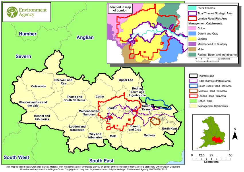
CONTENTS

1     Introduction ................................................................................................................... 7
    1.1     Introducing this report ............................................................................................. 7
    1.2     Background to the FRMPs ...................................................................................... 8
    1.3     The Thames RBD FRMP ........................................................................................ 8
    1.4     Background to Habitats Regulations Assessment ................................................. 10
2     European sites in the Thames RBD ............................................................................ 12
    2.1     European sites that could be affected by the FRMP.............................................. 13
    2.2     European sites and their status for FRMPs ........................................................... 13
    2.3     European sites and their management.................................................................. 14
3     Approach to the HRA .................................................................................................. 15
    3.1     Description of the FRMP programmes of measures .............................................. 15
    3.2     Screening and Likely Significant Effects................................................................ 16
    3.3     Screening out catchments where no European Sites are present ......................... 16
    3.4     Screening out measures that would not have physical effects .............................. 16
    3.5     Considering measures from existing plans ............................................................ 17
    3.6     Considering new measures for FRMP cycle 1 ....................................................... 18
    3.7     Considering the need for further stages of assessment ........................................ 18
4     Thames River Basin District Catchments HRA ............................................................ 20
    4.1     Summary of Measures .......................................................................................... 20
    4.2     Screening and Likely Significant Effects................................................................ 23
    4.3     Consideration of results and conclusion ................................................................ 48
5     Medway Flood Risk Area HRA .................................................................................... 51
    5.1     Summary of Measures .......................................................................................... 51
    5.2     Screening and Likely Significant Effects................................................................ 52
    5.3     Consideration of results and conclusion ................................................................ 53
6     London Flood Risk Area HRA ..................................................................................... 55
    6.1     Summary of Measures .......................................................................................... 55
    6.2     Screening and Likely Significant Effects................................................................ 57
    6.3     Consideration of results and conclusion ................................................................ 61
7     In combination effects with other plans and projects.................................................... 63
    7.1     RBD and FRA FRMPs .......................................................................................... 63
    7.2     In-combination effects between RBD FRMPs ....................................................... 64
    7.3     In-combination effects with external plans ............................................................. 64
8     Conclusion and Future HRAs ...................................................................................... 66
Annex A:
Table A1 – HRA screening table for the FRMP measure categories
Table A2 – Management Catchments and European sites in the Thames RBD / FRMP
Table A3 – Mitigation and Control Measures

Annex B – Thames RBD European sites

1. Introduction
1.1. Introducing this report
This report sets out the results of a strategic- plan level Habitat Regulations Assessment
(HRA) into the likely significant effects on designated ‘European sites’ of the Flood Risk
Management Plan (FRMP) for the Thames River Basin District published in December 2015.
The HRA report has been prepared by the Environment Agency on behalf of the collective
Risk Management Authorities (RMAs) that have responsibilities for information being
published within the FRMP and are thus the ‘competent authorities’ for the HRA of their
respective published information, as follows:
Information on flooding from main river, sea and reservoirs being published for the
catchments of the river basin district (RBD) are the responsibility of the Environment
Agency (for English catchments).
Information on flooding from local sources being published for any Flood Risk Areas
(FRA) is the collective responsibility of Lead Local Flood Authorities within the FRA.
In preparing the HRA report the Environment Agency has consulted with Natural England
(for English catchments) and Natural Resource Wales (for Welsh catchments). The Lead
Local Flood Authorities in Flood Risk Areas are ‘competent authorities’ for HRA of their
FRMP information and have agreed that this report will meet their HRA requirements.
FRMPs are new strategic plans for implementing the Flood Risk Regulations 2009 and the
existing National Flood and Coastal Erosion Risk Management (FCERM) Strategy for
England. They have been developed for River Basin Districts (RBDs) and Flood Risk Areas
(FRAs) and draw together information from a range of existing strategies and plans that are
in place and continue to be maintained by Risk Management Authorities. The HRA has been
carried out at the level of detail published in the FRMP and takes into account HRAs that
have already been undertaken for measures in existing plans, and at the level of detail
provided by these existing plans. Whilst a HRA at this strategic level cannot obtain the level
of detail necessary for in-depth assessment, the HRA summarises the likely risks and
potential need for controls and mitigation and the range of generic mitigation options
available, which will then proceed through further consideration once measures are
developed as specific local actions. In this way, this high- level HRA will be helpful for future
HRAs that consider the effects on European sites at a project level.
The report describes each of the main stages and results of the FRMP HRA as follows:
Describing the network of European sites within the RBD (chapter 2)
The approach to the HRA (chapter 3)
Screening and assessing likely significant effects (chapters 4,5,6)
Appropriate assessment, alternative solutions and IROPI (chapters 4,5,6)
Conclusion and future HRAs (chapter 8).1.2. Background to the FRMPs
Flood risk management plans (FRMPs) highlight the hazards and risks from rivers, the sea,
surface water, groundwater and reservoirs and set out how risk management authorities,
such as the Environment Agency and local authorities will manage flood risk. They are
required by the European Union Floods Directive and the Flood Risk Regulations 2009. The
FRMPs must be reviewed and reissued every six years to describe progress.
The Environment Agency is required to prepare flood risk management plans for all of
England covering flooding from main rivers, the sea and reservoirs. Lead Local Flood
Authorities (county councils and unitary authorities) must prepare flood risk management
plans for flood risk areas (there are ten flood risk areas in England) where the risk of flooding
from local sources is significant as identified in Preliminary Flood Risk Assessments.
The 2015-2021 period will be the first cycle of the FRMPs, however RMAs already plan for
flooding and a large proportion of the FRMPs are taken from existing plans that have already
been consulted on and published. This includes plans such as Catchment Flood
Management Plans (CFMPs) and Shoreline Management Plans (SMPs) as well as Local
Flood Risk Management Strategies that have been developed by local authorities.
Some further strategic developments have been included for the 2015-2021 first cycle of the
FRMP that build on existing plans and seek to address the key objectives of the Flood Risk
Regulations 2009 such as: strengthening joint working of RMAs, developing more integrated
management of the water environment, and updated priorities from any new understanding
of flood risks including the implications of climate change.
1.3. The Thames RBD FRMP
The Thames River Basin District (RBD) covers a relatively small area of the UK in terms
area but contains a large proportion of the population, around 15 million people. The majority
of people live in London. Other large centres of growing population include Reading,
Swindon and Crawley. Intensification of land use is resulting in increase rainfall runoff in both
urban and rural areas where land has been developed and is used productively.
The Thames RBD has many significant wetland and wildlife sites including protected
marshes and chalk streams. There are many areas where the water environment is
particularly important including rare wildlife habitats, bathing waters and areas where
drinking water is abstracted.
Climate in the RBD is expected to change in general terms broadly in line with predictions for
the rest of the UK. It is likely that summers will become hotter and drier and winters warmer
and wetter. It is likely under these conditions that flood risk will generally increase in the
RBD, including as a result of sea level rise.
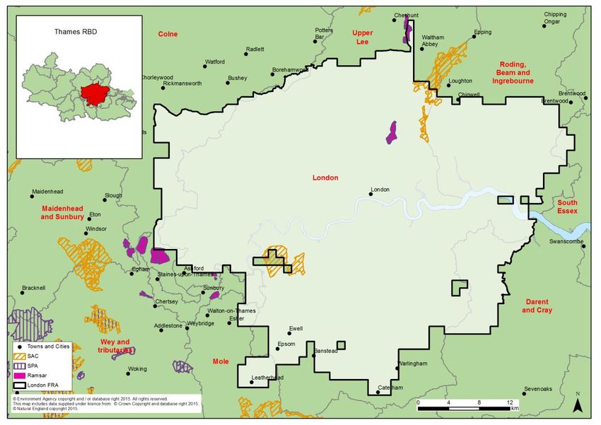
The Thames RBD is made up of 17 management catchments (see map in Figure 1 below).
The FRMP describes the scale of flood risk in the Thames RBD which includes:
Flooding from rivers, the sea, surface water, groundwater, storm water drainage
(including highways), sewer systems and failure or overtopping of water control
structures. In London, the majority of rivers have been modified to carry water efficiently through
artificial and straightened channels. Most of their floodplains have been heavily
developed and flooding can happen very quickly.
Historically extensive, catchment-wide river flooding in the Thames river basin has
happened when heavy and prolonged rainfall occurs when the catchment is either
frozen or saturated, between the autumn and spring. These very large scale floods
can affect 1000’s of properties across the RBD.
More recently, in 2000, conditions were such that groundwater flooding also occurred
across much of the chalk down-land. Because of the size of the RBD, flooding is
sometimes confined to sub-catchments as a result of storms and depressions only
affecting part of the basin.
Urban catchments are particularly vulnerable to river flooding as a result of increased
surface water run-off from impermeable surfaces. Surface water flooding occurs as
drainage systems become overloaded with high volumes of rainfall.
Figure 1 Thames RBD catchments and Flood Risk Areas
The Thames RBD FRMP sets out the objectives and measures to manage flood risk, from
the Environment Agency and the Lead Local Flood Authorities for the Thames RBD.
Measures within the FRMPs have been developed by the Environment Agency and the Lead
Local Flood Authorities (LLFAs) within the respective FRMP areas.
Measures within the FRMPs are either already developed, these are derived from existing
plans, which have been separately consulted on and published with accompanying
assessment, including Habitats Regulations Assessment (HRA); or new measures,developed specifically for inclusion in the FRMP. The source of the measures has
determined how they have been treated in the HRA.
Existing plan measures in the Thames FRMP are derived from the following source plans:
The River Medway to Swale Estuary Shoreline Management Plan (SMP)
The Isle of Grain to South Foreland (SMP)
The Thames Catchment Flood Management Plans (CFMP)
The North Kent Rivers CFMP
The Medway CFMP
Local Flood Risk Management Strategies (FRMS) developed by LLFAs
Surface Water Management Plans (SWMP’s)
The Thames Estuary 2100 Plan
London FRA Local Strategies
London FRA SWMP’s
Medway SWMP’s
Other Local Plans.
The FRMP is divided into the separate plans that are the responsibility of different risk
management authorities, as follows:
Measures within the 17 RBD catchments of the Thames RBD that the Environment
Agency is responsible for, and
Measures within the Medway Flood Risk Area (FRA) for local sources of flooding
that fall within the Medway management catchment. The Lead Local Flood
Authorities (LLFAs) whose administrative boundaries fall within the Medway FRA are
responsible for these measures.
Measures within the London FRA for local sources of flooding that fall within the Lee,
London, Colne, and Roding, Beam and Ingrebourne management catchments. The
LLFAs whose administrative boundaries fall within the London FRA are responsible
for these measures.
1.4. Background to Habitats Regulations Assessment
In England, the Conservation of Habitats and Species Regulations 2010, as amended,
commonly termed the Habitats Regulations, implements the European Union Habitats
Directive (Directive (92/43/EEC) on the Conservation of natural habitats and of wild flora and
fauna, and certain elements of the Wild Birds Directive (2009/147/EC). This legislation
provides the legal framework for the protection of habitats and species of European
importance in England.
Sites protected under the Habitats Regulations comprise Special Protection Areas (SPA),
Special Areas of Conservation (SAC), candidate SACs (cSAC), Sites of Community
Importance (SCI) and, as a matter of government policy, to potential Special Protection
Areas (pSPA) and Ramsar sites (sites designated under the 1971 Ramsar Convention for
their internationally important wetlands). These sites are referred to collectively as in this
report as ‘European sites’.Regulation 9(3) of the Habitats Regulations requires that a ‘competent authority’ must consider the requirements of Habitats Directive in exercising any of its functions. Article 6(3) of the Habitats Directive defines the requirements for assessment of plans and projects potentially affecting European sites. This requires that a competent authority, before deciding to undertake, or give any consent or authorisation for a plan or project which is likely to have a significant effect on a European site, and is not directly connected with or necessary to the management of that site, must carry out an appropriate assessment. The term commonly referred to for the assessment process is ‘Habitats Regulations Assessment’. The Thames FRMP is considered to fit within the definitions of a ‘plan’ as defined by the Habitats Directive, and requires a Habitats Regulations Assessment (HRA). The FRMP is a high-level planning document for the Thames River Basin District (RBD) (see map in Figure 2), therefore potential impacts of the plan on European sites across the RBD are difficult to determine. Given the geographic scale and nature of the plan, the HRA needs to be tailored to be appropriate for the spatial area of coverage and the strategic nature of the plan. The Habitats Regulations Assessment has followed a framework of four distinct stages, only moving to the next stage if required by the results of that stage of the assessment. The four stages are: Stage 1: Screening and Likely Significant Effects is the process which initially identifies the likely impacts upon a European Site of a plan or project, either alone or in combination with other plans or projects, and considers whether these impacts may be significant. This stage also includes the development of mitigation to avoid or reduce any possible impacts. Stage 2: Appropriate Assessment is the detailed consideration of the impact on the integrity of the European Site of the plan or project, either alone or in combination with other plans or projects, with respect to the site’s conservation objectives and its structure and function. This is to determine whether there is objective evidence that adverse effects on the integrity of the site can be excluded. This stage also includes the development of mitigation to avoid or reduce any possible impacts. Stage 3: Assessment of alternative solutions is the process which examines alternative ways of achieving the objectives of the plan or project that would avoid adverse impacts on the integrity of the European Site, should avoidance or mitigation be unable to avoid adverse effects. Stage 4: Assessment where no alternative solutions exist and where adverse effects remain is made with regard to whether or not the plan or project is necessary for imperative reasons of overriding public interest (IROPI) and, if so, of any required compensatory measures.
2. European sites in the Thames RBD
Within the Thames RBD there are 29 SACs, 12 SPAs, and 8 Ramsar sites. Several sites
have multiple designations such as the Lee Valley, Medway Estuary and Marshes, and the
South West London Waterbodies, parts of these sites being designated as both SPA and
Ramsar sites. Figure 2 shows a map of the Thames RBD with the European sites and the
management catchments of the Thames RBD.

Figure 2 - Map of the European sites in the Thames River Basin District

Although most of the European sites in the RBD contain a variety of habitat types, broadly
speaking they can be described as coastal / marine sites, freshwater sites such as gravel
pits, water supply reservoirs and semi-natural lakes and terrestrial sites such as woodlands,
several types of grasslands, and bogs. In general the European sites are broadly clustered
in either the central southern, or far eastern area of the RBD, with a relative absence of sites
towards the west.

Of the 8 Ramsar sites in the RBD, 5 are coastal which occur in the Thames Estuary. One of
the largest at 6500 ha is The Swale on the North Kent coast, a complex of brackish and
freshwater habitats where birds breed in important numbers. By contrast a significantly
smaller inland freshwater site (at 830ha) is the South West London Waterbodies in Surrey, a
series of embanked freshwater reservoirs and former gravel pits which provide important
feeding and roosting sites for a diverse range of wintering wildfowl.

Of the 12 SPA sites in the RBD, 6 are coastal and 4 inland terrestrial. Of the coastal sites in
the RBD Benfleet and Southend Marshes (at 2251 ha), located on the north shore of the
Thames Estuary is particularly renowned regionally for cockle shell banks, extensive
mudflats and grassland that support a diverse flora and fauna. These habitats provide a wide
range of feeding and roosting opportunities for internationally important numbers of wintering
wildfowl and waders. Ashdown Forest, an example of a terrestrial inland SPA site in East
Sussex (at 3207ha), has a diverse range of scrub and mixed woodland and contains one of
the largest single continuous blocks of lowland heath in south-east England. These habitats
support birds of European importance such as European Nightjar, Dartford warbler and
Eurasian hobby.

SAC sites in the RBD are the most widespread in occurrence, and comprise the largest
diversity of habitat types. These sites range from internationally rare chalk streams, to mixed
use parkland sites such Richmond Park, through to mosaics of heath, scrub and bog, such
as Shortheath Common in Hampshire. The (5154 ha) composite Thursley Ash Pirbright and
Chobham SAC in Surrey captures this diversity, being made up of numerous standing and
running waterbodies, bogs, marshes, fens, heath habitat and coniferous woodland.

Annex B contains a summary of the European sites present within the Thames RBD. Table
A2 in Annex A presents a summary of the European sites present within the management
catchments of the Thames RBD. In a number of cases European sites cross over the
boundary of two or more management catchments, therefore a number of European site
names / designations may appear against more than one management catchment.

2.1.    European sites that could be affected by the FRMP
The Thames RBD FRMP is a long term plan for the water environment, which could
potentially affect both water dependent and non-water dependent European sites and their
qualifying features.

It is not possible from the outset to rule out, at the RBD scale, any (water-dependent or non
water-dependent) European sites from being affected by the Thames RBD FRMP. This
HRA (in particular Sections 4.2, and sections 5.2 / 6.2 for the two FRAs) reviews the
European sites by management catchment, and determines whether any of the measures
within the catchments are likely to lead to significant effects on European sites.

2.2.    European sites and their status for FRMPs
The Thames RBMP provides summary information on the current status and baseline for
water-dependent European Sites as part of its monitoring data.

European Sites in England, with the occasional exception, are also designated as SSSIs.
Natural England monitors the conditions of SSSIs and their component units using six
reportable condition categories: favourable; unfavourable recovering; unfavourable no
change; unfavourable declining; part destroyed and destroyed.

The current status of water-dependent European site protected areas for the Thames RBD is
summarised in Table 1 below. This gives the current area of water-dependent SSSI units of
European protected areas in different condition categories as currently recorded on Natural
England’s designated site data system. SSSI units underpin European protected areas and
Natural England only collects data at a SSSI unit level. When SSSI units are in favourable
condition, they are deemed to be meeting their conservation objectives.
Table 1 Status of water-dependent European sites based on assessment of
SSSI Units for the Thames RBD (Extract from Natural England databases
August 2015)
Thames RBD
Condition (ha)
Favourable 24,708
Destroyed / Part
destroyed 0
Unfavourable declining 131
Unfavourable no change 227
Unfavourable recovering 7,357
Total Area Unfavourable 7,715
% Unfavourable 24
This shows that for the Thames RBD, 24% of water-dependent SSSI units of European
protected area sites are currently not compliant with the condition requirements.
The generic pressures on such sites in the Thames region include most commonly lack of
direct corrective action to improve condition of sites such as weed control in water
dependent habitats but also application of inappropriate agricultural practices. These can
include over cutting or mowing, or under-grazing of grassland sites and inappropriate scrub
control in heathland areas. Public disturbance can also be a pressure, particularly on ancient
woodland SSSI’s.
There are also long term national threats to habitats and especially species, including
climate change, alterations in hydrological and coastal processes and invasive non-native
species.
2.3. European sites and their management
As part of a new strategic approach to managing all England’s European sites, new
measures needed to achieve favourable conservation status for all European sites in
England have been developed by Natural England. These are collectively referred to as Site
Improvement Plans (SIPs), and are being developed by the Improvement Programme for
England’s Natura 2000 sites (IPENS). SIPs were published for all European sites in England
in 20152.
The Thames FRMP recognises SIPs include actions where flood risk management is
specifically a mechanism for their delivery. The following are the relevant SIPs for Thames
RBD:
Site Improvement Plan: Epping Forest (SIP076)
Site Improvement Plan: River Lambourn and Kennet-Lambourn Floodplain (SIP112).
2
Site Improvement Plans for the Thames River Basin District can be found on:
http://publications.naturalengland.org.uk/category/62871977831956483. Approach to the HRA
The steps undertaken to complete the HRA are as follows:
describe the plan and the measures proposed
screen and assess the likely significance of any effects on European Sites
consider need for further stages of assessment (i.e. appropriate assessment,
alternative solutions and IROPI)
determine a plan level conclusion
3.1. Description of the FRMP programmes of measures
The Thames RBD FRMP is a joint publication of several plans required under the Flood Risk
Regulations that are the separate responsibilities of specific Risk Management Authorities
(RMAs), as follows:
Thames River Basin District catchments (Environment Agency)
Medway Flood Risk Area (LLFAs within the FRA)
London Flood Risk Area (LLFAs within the FRA).
3.1.1. River Basin District Catchments
FRMPs for the River Basin District (RBD) are being published by the Environment Agency
(for English catchments) and Natural Resources Wales (NRW) (for Welsh catchments), and
are focused on measures principally to address flood sources from main river, the sea and
reservoirs. The measures have been divided into catchments based on the River Basin
Management Plans (where they are called ‘management catchments’).
Production of the FRMPs for the RBDs is the legal duty of the Environment Agency and
NRW. Where any voluntary information on local sources of flooding within RBD catchments
has been provided by LLFAs, these are published by joint agreement in the RBD FRMP.
The Environment Agency and NRW are also the competent authority under the Habitats
Regulations for the RBD FRMPs.
3.1.2. Flood Risk Areas
FRMPs for Flood Risk Areas (FRAs) are being published by the Lead Local Flood
Authorities (LLFAs) where the FRAs lie within their administrative boundaries. Production of
the FRMPs for the FRAs is the legal duty of the respective LLFAs. The LLFAs responsible
for the FRA FRMPs are also the competent authority under the Habitats Regulations.
Where a RBD includes one or more FRA, as is the case for the Thames RBD, the measures
that have been developed specifically for these FRA FRMPs are presented and assessed
separately.
3.1.3. Applying HRA
In applying the HRA process, each RMA plan has been assessed separately. A final
summary of conclusions and recommendations for future HRAs is provided that also draws
on a high-level summary of the potential for in-combination effects of the FRMP with other
key plans.3.2. Screening and Likely Significant Effects
This first step of the HRA process requires consideration of screening and likely significant
effects of measures on European Sites. The tasks undertaken to complete this are as
follows, set out in more detail below:
screening out catchments where no European Sites are present
screening out measures that would not have physical effects
considering measures from existing plans, with mitigation / controls already agreed in
HRAs for any likely significant effects, or in some cases potential adverse effect on
site integrity
considering new measures and their likely significant effects, with mitigation / controls
where considered necessary
conclusion from screening and likely significant effects.
The results of these tasks for each RMA’s plan of the FRMP are provided in the following
chapters:
Chapter 4: Thames River Basin District catchments
Chapter 5: Medway Flood Risk Area
Chapter 6: London Flood Risk Area.
3.3. Screening out catchments where no European Sites are present
Where there are no European sites present in a catchment, it was determined that no further
consideration of measures in the catchment is required. Given the level of detail in the plan
where the FRMP measures are mainly strategic in nature and are not specific on their
precise location, there is insufficient details to consider downstream or down drift effects
beyond the catchment. However, such screening for cross-catchment effects will be a
requirement in assessing local plans and projects.
3.4. Screening out measures that would not have physical effects
Every measure included within the FRMP is categorised according to one of the following 5
categories, accompanied by an M-code:
Prevention (M2) - reducing the impacts of flooding through land use and
development policy, relocation of assets at risk, or measures to divert the hazard to
avoid harm.
Protection (M3) - protecting people from the risk of flooding; for example, by the
maintenance, refurbishment of existing defences or building new defences.
Preparedness (M4) - by taking actions that prepare people for flooding; for example,
by improving awareness of flood risk, or by providing warning and forecasting for
floods. Recovery and review (M5) - supporting recovery after flooding has happened and
reviewing how things can be improved; for example, by improving the availability of
recovery services such as providing temporary accommodation.
Other (M6) – measures not fitting in to any of the above categories.
Further definitions of each of the measures are set out in the FRMP according to a second
tier of M-codes. For example, Prevention (M2) includes the second tier measure, M22, which
is defined as “Prevention, removal or relocation measure to remove receptors from flood
prone areas or to relocate receptors to areas of lower risk”. These measure definitions have
been used as the basis for the initial screening out of the measures that require no for further
consideration within the HRA.
The measure codes and their definitions are included as Table A1 (in Annex A to this
document). Measures under ‘Preparedness’ (M4) and ‘Recovery and review’ (M5) will not
result in development, demolition or changes of management ‘on the ground’ that could
result in affects on European Sites. These were therefore screened out from any further
consideration. Similarly, under the ‘Prevention’ category (M2), only the removal or relocation
of receptors from flood prone areas could potentially affect European sites. The measures
that have been screened in to the assessment are set out below and have been highlighted
in Table A1:
M22 – Prevention – removal or relocation (category)
M3 – Protection – all sub-categories
M6 – Other – not yet defined.
3.5. Considering measures from existing plans
Risk Management Authorities have a range of plans in place for developing and
implementing measures related to flooding from main river (in Catchment Flood
Management Plans), to flooding from the sea (in Shoreline Management Plans) and related
to local sources of flooding (e.g. in Local Flood Risk Management Strategies). These plans
have been subject to HRA where relevant, and have reported on the effects on European
Sites consistent with the level of detail of the plans.
For this HRA, these existing HRAs have been used to summarise the effects of measures
from existing plans that are now set out under specific RBD catchments or FRAs. For many
RBD catchments and FRAs there are multiple existing plans covering the geographic area
but also some existing plans that are split across RBD catchments or FRAs. Nonetheless we
have separated out the ‘screened in’ measures from individual existing plans and referenced
the specific HRA results that apply to them.
The results from existing HRAs have considered the extent that they remain valid since they
were published. This has been done by checking the status of the relevant European sites
that were considered within the source plan’s HRA for any changes to site designations
since the date of the HRA publication. The criteria were agreed with Natural England and
comprised: whether there were any new / additional site designations, any changes in site
boundaries, changes in designated site features, or any significant changes in site
conditions.The HRA results from Shoreline Management Plans are relatively recent with most
published between 2010 and 2011. The HRA results from Catchment Flood Management
Plans are a little older with most published between 2008 and 2010. The HRA results from
Local Flood Risk Management Strategies are the most recent with the first ones being
published around 2012 and most being published much more recently.
One of the main reasons for a likely change from when the effects of plan measures were
reported in HRAs is where there have been boundary changes to European sites or to the
scope of condition of the interest features of the sites i.e. specific habitats, species etc.
Where we have been advised that such changes have occurred and are significant then this
has triggered further consideration of the validity of the existing HRA results that we have
relied upon.
3.6. Considering new measures for FRMP cycle 1
In reviewing the range of measures across existing plans covering all sources of flooding,
Risk Management Authorities (RMAs) have taken the opportunity to put forward further
strategic developments for the next 6 year cycle of the FRMP. These ‘new measures’ focus
on: strengthening the joint working of RMAs across all flood sources; developing more
integrated management of the water environment as set out in the River Basin Management
Plans and other related plans; and updating flood risk information to help manage risks with
communities.
For this HRA we have reviewed the set of new measures that have been ‘screened in’ for
each catchment. As they are mostly ‘strategic’ measures without specific information on
location or the form of action that would be developed on the ground, we have considered a
range of factors that would give rise to any likely risks from this set of measures in a specific
catchment, which includes:
their general proximity in the catchment to European sites
whether they aim to address sources of flooding that are local, or main river or
related to the coast
the mix of types of new measures within the catchment denoted by their M-codes
(i.e. whether they are mainly maintenance, or channel works, or new solutions).
General proximity was considered by narrowing down the set of measures within a
catchment to those that were closer in general and more likely to be connected to European
sites by the hydrology of the catchment rather than applying specific buffer distances to
individual measures.
3.7. Considering the need for further stages of assessment
HRA steps were carried out for each RBD catchment of the RBD plan that is the
responsibility of the Environment Agency. Further HRA steps were carried out for each FRA
(by catchment) that is the responsibility of respective Lead Local Flood Authorities. The
determination for each catchment or FRA that there are no likely significant effects to
European sites is based on the following assumptions:
that this HRA does not remove the need for HRA at a subsequent level, i.e. lower tier
strategies, plans or projects that implement measures, nor does it give any weight totheir outcomes. Consideration of potential impacts and options available to mitigate
for those impacts should assist, but not influence or constrain any lower-tier
assessments.
that as local actions are developed at a project level and the details of their scope
and scale are known, that this may identify additional effects on European Sites that
have not been assessed here, or were not appropriate to consider at this spatial
scale of plan.4. Thames River Basin District Catchments HRA This chapter sets out the results of carrying out the HRA on the measures for the Thames RBD catchments that are for flooding from main river, sea and reservoirs and for local flooding sources outside of Flood Risk Areas. This is the FRMP information for which the Environment Agency is the FRMP ‘statutory authority’ and HRA ‘competent authority’. The Flood Risk Area FRMP information for which other RMAs have responsibility has been considered separately in later chapters of the HRA (see sections 5 and 6). This section covers the following stages of the assessment: Summary of measures being assessed Screening and assessment of likely significant effects Consideration of results and conclusion. 4.1. Summary of Measures The initial screening and assessment of likely significant effect reviewed the measures for each of the 17 management catchments within the Thames FRMP. Figure 3 - Map of the Thames river basin district and management catchments A summary of the measures and their screening is given below for each catchment.
Table 2 Summary of measures by catchment
Management                                                      Number of measures related                     Number of new measures and
                                                                                           1                                         1

                    Number of measures

                                         Number of measures

                                                                                                                                               Number of European
Catchment                                                       to types of existing plans                     known level of detail

                                                            1
                                         from existing plans

                                                                                               measures for cycle
                    screened in (out)

                                                                                               Number of new

                                                                                                                                               Sites
                                                                                                   1
                                                                                               one
Catchments with no European sites present
Cherwell and       0 (39)                No screened in measures as no European sites present                                                  0
Ray
Darent and Cray    0 (41)                                                                                                                      0
Cotswolds          0 (10)                                                                                                                      0

Catchments with no screened in measures
All remaining catchments have some screened in measures
Catchments with all measures from existing plans
Medway            42 (53)                          42           19 from CFMPs                        0                No new measures          9
                                                                23 from SMPs/other EA plans

Mole               9 (9)                                9       9 from CFMPs                         0                                         2

North Kent        18 (20)                          18           1 from CFMPs                         0                                         5
                                                                17 from SMPs

Sub-total          69                              69           29 from CFMPs                        0
                   (172)                                        40 from SMPs/other EA plans

% all measures     9%                           9%                                              (n/a)

Catchments with new measures for cycle 1 of the FRMP
RBD-wide           4 (13)                               2       2 from CFMPs                         2         0 not in proximity              49
                                                                                                               2 strategic/proximity unknown
                                                                                                               0 specific/in proximity

Colne              11                                   2       2 from CFMPs                         9         8 not in proximity              4
                   (35)                                                                                        0 strategic/proximity unknown
                                                                                                               1 specific/in proximity

Gloucestershire    8 (25)                               6       6 from CFMPs                         2         2 not in proximity              5
and the Vale                                                                                                   0 strategic/proximity unknown
                                                                                                               0 specific/in proximity

Kennet and         2 (16)                               2       2 from CFMPs                         0         0 not in proximity              4
tributaries                                                                                                    0 strategic/proximity unknown
                                                                                                               0 specific/in proximity

Loddon and         3 (21)                               3       3 from CFMPs                         0         0 not in proximity              2
tributaries                                                                                                    0 strategic/proximity unknown
                                                                                                               0 specific/in proximity

London             72                              54           17 from CFMPs                     18           18 not in proximity             9
                   (90)                                         33 from other EA plans                         0 strategic/proximity unknown
                                                                4 from LLFA plans                              0 specific/in proximity
Maidenhead and 9 (18) 8 3 from CFMPs 1 0 not in proximity 6
Sunbury 5 from other EA plans 0 strategic/proximity unknown
1 specific/in proximity
Roding, Beam 19 14 10 from other EA plans 5 1 not in proximity 1
and Ingrebourne (50) 4 from LLFA plans 4 strategic/proximity unknown
0 specific/in proximity
Thames and 6 (24) 5 5 from CFMPs 1 1 not in proximity 4
South Chilterns 0 strategic/proximity unknown
0 specific/in proximity
Upper Lee 6 (21) 4 4 from LLFA plans 2 2 not in proximity 3
0 strategic/proximity unknown
0 specific/in proximity
South Essex 36 32 24 from other EA plans 4 2 not in proximity 4
(46) 8 from LLFA plans 2 strategic/proximity unknown
0 specific/in proximity
Wey and 4 (15) 3 3 from CFMPs 1 0 not in proximity 11
tributaries 0 strategic/proximity unknown
1 specific/in proximity
Sub-total 180 135 43 from CFMPs 45 34 not in proximity
(374) 72 from other EA plans 8 strategic/proximity unknown
20 from LLFA plans 3 specific/in proximity
2
% all measures 23% 17% 6% 34 (4%) 8 (1%) 3 (SMP is managing likely adverse effects such as in the catchments of Medway and North Kent. 4.1.2. Risks from new measures 6% of all FRMP measures (excluding Flood Risk Areas) are screened in and new measures, 1% are strategic without locations, 4% are not in proximity to any European Sites and
4.2.3.       Management Catchments with all measures from existing plans

The following management catchments in the Thames FRMP do not contain any
FRMP new measures; they contain only measures from existing plans.

Each of these plans has already been subject to consultation and assessment, including
HRA. The HRA conclusions for those source plans have been referred to in each case.

4.2.3.1.     Medway Management Catchment
 European        New measures                     Existing plan measures
 sites
                  Screened in     Screened out       Screened in        Screened out
         9
                       0               0                 42                  53

The Medway management catchment contains 9 European sites. There are no new
measures within this catchment; all of the 95 measures are from existing plans. 42 are
screened in and 53 are screened out.

The 9 European sites in the Medway catchment comprise the Ashdown Forest SAC and
SPA in the far south of the catchment, south east of East Grinstead; Peter’s Pit SAC
immediately north west of Burnham; Medway Estuary and Marshes SPA and Ramsar
fringing the River Medway Estuary north of Chatham; Thames Estuary and Marshes SPA
and Ramsar, and the Outer Thames Estuary SPA in the very north of the catchment on the
fringe of the Thames Estuary, North of Cliffe, St Mary Hoo and Lower Stoke; North Downs
Woodlands SAC in two discrete areas between Maidstone and Chatham, immediately north
of Snodland; and Boxley and Queensdown Warren SAC immediately South-East of
Chatham.

Medway CFMP

The Medway CFMP contains 24 screened out measures; these comprise flood risk reduction
/ prevention measures and avoidance measures relating primarily to avoiding inappropriate
development.

The CFMP contains 15 screened in protection measures of which the majority are channel
coastal and floodplain measures in connection with System Asset Management Plans.
These support recurring maintenance of assets which protect residential properties from
fluvial flooding in the Medway catchment. The remaining screened in measures are other
measures which include the implementation of the Middle Medway Strategy and WFD
actions which support flood risk management and habitat improvement of the River Beult.

The Medway CFMP measures implement the policies of the CFMP, which were assessed by
the Medway CFMP HRA, which concluded that there were no schemes proposed (or
identified for future need) that would affect site interest features or site integrity.

Proposed mitigation and/or compensation measures: comprised the need to develop
any further FRM plans/projects to be in consultation with Natural England and subject to
assessments as required under the Habitats Regulations.
North Kent Rivers CFMP The North Kent Rivers CFMP contains 4 screened out measures, comprising flood risk prevention / reduction or avoidance measures. The North Kent Rivers CFMP contains 4 screened in protection measures, and includes channel, coastal and floodplain works connected with System Asset Management Plans, reoccurring maintenance, SWMP measures to create and restore habitat and maintain outfalls for elvers. The CFMP measures implement the policies of the North Kent Rivers CFMP, which were assessed by the North Kent Rivers CFMP HRA. The HRA concluded that it is uncertain whether the plan will adversely affect the integrity of European sites as the CFMP is high level and lacks detail on the practical delivery of measures at specific areas that will be affected by the implementation of the plan. Proposed mitigation and/or compensation measures: comprised the need for an assessment at the project level and to ensure that no adverse effects on integrity result from policies and the resultant projects. River Medway and Swale Estuary SMP The River Medway and Swale Estuary SMP, (August 2008) contains 15 screened out measures, relating to public awareness and preparedness, and other preparedness measures, engagement activities and monitoring. The SMP contains 9 screened in channel, coastal and floodplain work measures. These measures all relate to undertaking capital maintenance and/or raising defences in the following policy units: PU2 Medway Bridge to North Halling, 5 Grain Tower to Colemouth Creek, 7 Power Station to Cockham Wood, 26 Kingsnorth Power Station. 27 North Halling to Snodland, 28 Snodland to Allington Lock, 29 Allington Lock to North Wouldham 31 Medway Bridge to West St Mary's Island, The River Medway and Swale SMP measures implement the policies of the SMP which were assessed by the River Medway and Swale SMP HRA. The Medway Estuary and Marshes Ramsar and SPA, the Thames Estuary and Marshes Ramsar and SPA, Ashdown Forest SAC and SPA, North Downs Woodlands SAC, Peter’s Pit SAC and Queendown Warren SAC lie within the catchment boundary. The HRA concluded that the SMP policies would have an adverse effect on the integrity of the Medway Estuary and Marshes and the Swale SPA / Ramsar site, through displacement of Grazing Marsh and Standing Water habitats. As a consequence a statement of Imperative Reasons for Overriding Public Interest (IROPI) was prepared and submitted to the Secretary of State for Defra, which was subsequently approved. Compensation measures were developed in Partnership with Natural England following. Defra Policy Guidance on Coastal Squeeze and are proposed to be resourced within the Southern Regional Habitat Creation Programme. 3 Sites for Freshwater Grazing Marsh
compensation are identified as part of this programme at locations at Rank 1 the North
Swale, Rank 2: South Swale, and Rank 3: at Hoo St Werberg.

Isle of Grain to South Foreland SMP

The 2 measures from the SMP are screened in, comprising channel, coastal and floodplain
works - the Yanlet Creek Realignment Study; and maintain existing beach through recharge
and recycling in PU12 Allhallows-on-Sea to Grain.

The Isle of Grain to South Foreland SMP measures implement the policies of the SMP,
which were assessed by the Isle of Grain to South Foreland SMP HRA.

The HRA concluded that it is not possible to demonstrate that the SMP does not have
an adverse effect on the integrity of the Thames Estuary & Marshes Ramsar / SPA,
and the Swale Ramsar / SPA. An application was made to the Secretary of State for Defra
to consider the case for IROPI, which was approved.

Proposed mitigation: and/or compensation measures: measures were developed in
partnership with Natural England following Defra policy guidance on coastal squeeze, and
are proposed to be resourced within the Southern Regional Habitat Creation Programme. 2
sites for freshwater grazing marsh compensation are identified as part of this programme at
locations in South Swale and possible additional sites within the Thames Estuary, to be
identified by the TE2100 programme.

Thames Estuary 2100 Plan

The Thames Estuary 2100 (TE2100) Plan contains 6 screened out measures; these include
5 public awareness and preparedness measures and 1 avoidance measure.

The plan contains 14 screened in measures; these comprise 9 other protection measures
concerning management / maintenance / improvement of existing defences, and 5 other
measures which relate to implementing intertidal habitat creation.

The TE2100 Plan measures implement the policies of TE2100 Plan which were assessed by
the TE2100 HRA. The HRA assessment shows all options to have a significant impact
on designated features on the Thames.

Proposed mitigation and/or compensation measures: comprises the replacement and
compensation for predicted impacts, which has been built in to the plan to maintain integrity
of the European sites [Natura 2000 Network]. The replacement and compensation is
currently being agreed on an ongoing basis.

Kent Flood Risk Management Strategy

The 2 measures from the Kent FRMS relate to flood risk modelling and are screened out.

4.2.3.2.    Mole Management Catchment
 European        New measures                      Existing plan measures
 sites
                 Screened in      Screened out     Screened in         Screened out
       2
                       0                0                 9                   9
The Mole management catchment contains 2 European sites. There are no new measures
within this catchment. This management catchment contains 18 measures from existing
plans.
The Mole catchment contains 2 European sites: The Mole Gap to Reigate Escarpment SAC
in the central area of the catchment, north east of Dorking and the Thames Basin Heaths
SPA in the north west of the catchment south west of Cobham.
Thames CFMP
9 measures are screened out as they relate to avoidance, removal or relocation; flood
forecasting and warning; emergency response planning / contingency planning; and public
awareness and preparedness.
9 measures are screened in, they comprise channel, coastal and floodplain works; water
flow regulation; and natural flood management measures.
The 9 CFMP protection measures within the Mole management catchment, implement the
policies of the Thames CFMP, which were assessed as part of the Thames CFMP HRA
screening. The HRA screening concluded that there would be no likely significant effect
on the European sites in the catchment.
4.2.3.3. North Kent Management Catchment
European New measures Existing plan measures
sites
Screened in Screened out Screened in Screened out
5
0 0 18 20
The North Kent management catchment contains 5 European sites. There are no new
measures within this catchment. All of the 38 measures are from existing plans. 18 are
screened in and 20 are screened out.
The management catchment contains 5 European sites: The Medway Estuary & Marshes
Ramsar and SPA in the far north west of the catchment in the area south of Queensborough;
the Outer Thames Estuary SPA, and the Swale Ramsar and SPA which fringes the large
majority of the northern boundary of the catchment along the coast between Witstable and
Sittingbourne; and the Blean Complex SAC in the very east of the catchment, east of
Yorkletts.
North Kent Rivers CFMP
The North Kent Rivers CFMP contains 3 measures, 2 of these are flood risk prevention /
reduction measures and are screened out. The 1 measure screened in is channel, coastal
and floodplain works measure.
The protection measure incorporated within the North Kent Rivers CFMP implements the
policies of the CFMP, which were assessed by the North Kent Rivers CFMP HRA. The
Medway Estuary and Marshes Ramsar site and SPA, the Swale Ramsar site and SPA and
the Blean Complex SAC lie within the catchment boundary.The HRA concluded that the determination of likely significant effect on the European site was Uncertain. It further states that The North Kent Rivers CFMP cannot be put into effect until more detailed appraisal and assessment has taken place on plans or projects arising out of this CFMP to show it and they have met the requirements of the Habitats Directive. River Medway and Swale SMP The Medway and Swale SMP contains 13 measures which are screened out. The majority of these relate to public awareness and preparedness measures, and also prevention measures. The SMP contains 4 screened in channel, coastal and floodplain works measures. These relate to maintaining and raising defences, in accordance with this SMP at several locations. These occur within the following policy units: 17, Kingsferry Bridge to Milton Creek; 23, Milton Creek and 37 Faversham to Nagden. The protection measures incorporated within the River Medway and Swale SMP implement the policies of the SMP which were assessed by the River Medway and Swale SMP HRA. The Medway Estuary and Marshes Ramsar site and SPA, the Swale Ramsar site and SPA and the Blean Complex SAC lie within the catchment boundary. The SMP HRA concluded that the SMP would have an adverse effect on the integrity of the Medway Estuary and Marshes and the Swale SPA/Ramsar network. A statement of case for Imperative Reasons for Overriding Public Interest (IROPI) was prepared and submitted to the Secretary of State. The IROPI case was approved by Defra. Proposed mitigation and/or compensation measures: comprises: compensatory habitat which will be quantified by the Lead Authority, with early advice from Natural England, to be secured via a Regional Habitat Creation Programme. Isle of Grain to South Foreland SMP This SMP contains 3 measures which are screened out; these are all other preparedness measures. The SMP contains 13 measures which are screened in, which all relate to channel, coastal and floodplain works, in numerous policy units covered by the SMP. These works include engineering works to maintain and hold the current line of defence applicable to policy units: PU13 Garrison Point to Minster; PU14 Minster Town; PU22 Seasalter to Whitstable Town Golf course and PU39 Sportsman Pub to Seasalter. Further coastal and floodplain work includes the construction of set-back defences within PU10, Leysdown-on- Sea to Shell Ness and PU11, Faversham Creek to Sportsman Pub. Beach Management Plans will be produced within PU39 Sportsman Pub to Seasalter; PU11 Faversham Creek to Sportsman Pub and PU13 Garrison Point to Minster. The protection measures incorporated within the SMP implement the SMP policies, which were assessed by the Isle of Grain to South Foreland SMP HRA. The Medway Estuary and Marshes Ramsar site and SPA, the Swale Ramsar site and SPA and the Blean Complex SAC and the Outer Thames Estuary SPA lie within the North Kent management catchment boundary.
You can also read