South West river basin district Flood Risk Management Plan 2015 to 2021 Habitats Regulation Assessment - March 2016 - Gov.uk
←
→
Page content transcription
If your browser does not render page correctly, please read the page content below
South West river basin district
Flood Risk Management Plan 2015
to 2021
Habitats Regulation Assessment

March 2016
Executive summary
The Flood Risk Management Plan (FRMP) for the South West River Basin District (RBD)
provides an overview of the range of flood risks from different sources across the 9
catchments of the RBD. The RBD catchments are defined in the River Basin Management
Plan (RBMP) and based on the natural configuration of bodies of water (rivers, estuaries,
lakes etc.).

The FRMP provides a range of objectives and programmes of measures identified to
address risks from all flood sources. These are drawn from the many risk management
authority plans already in place but also include a range of further strategic developments for
the FRMP ‘cycle’ period of 2015 to 2021. The total numbers of measures for the South West
RBD FRMP are reported under the following types of flood management action:

Types of flood management measures                                                 % of RBD
                                                                                   measures
Prevention – e.g. land use policy, relocating people at risk etc.                       21 %
Protection – e.g. various forms of asset or property-based protection                   54%
Preparedness – e.g. awareness raising, forecasting and warnings                         21%
Recovery and review – e.g. the ‘after care’ from flood events                            1%
Other – any actions not able to be categorised yet                                       3%

The purpose of the HRA is to report on the likely effects of the FRMP on the network of sites
that are internationally designated for nature conservation (European sites), and the HRA
has been carried out at the level of detail of the plan. Many measures do not have any
expected physical effects on the ground, and have been screened out of consideration
including most of the measures under the categories of Prevention, Preparedness, Recovery
and Review. Others that may have effects but are in catchments that do not have any
designated European sites have also been screened out of consideration.

Risk Management Authorities (RMAs) have for a long time been addressing the range of
flood risks through a range of plans and actions. Much of the South West RBD FRMP
presents measures that are ongoing from existing plans, which have already been subject to
HRA. RMAs have considered the effects of these existing plan measures on European sites
in published HRAs where required. These measures, their effects and agreed actions to
mitigate the effects have been summarised under relevant RBD catchments within this
report. Where RMAs have identified new flood risk management priorities for the next FRMP
cycle period between 2015 and 2021, then the measures to implement these have been
considered alongside existing plan measures in this HRA.

The following table summarises the numbers of measures that the HRA has considered:

FRMP RMA plans                         Screened out          Measures from     New cycle 1
                                          measures            existing plans    measures1
South West RBD catchments                 350 (44%)               268 (34%)      178 (22%)

1
 Measures across several catchments are counted up for each catchment for HRA purposes which
may be a different figure than reported in the FRMP.

                                                     2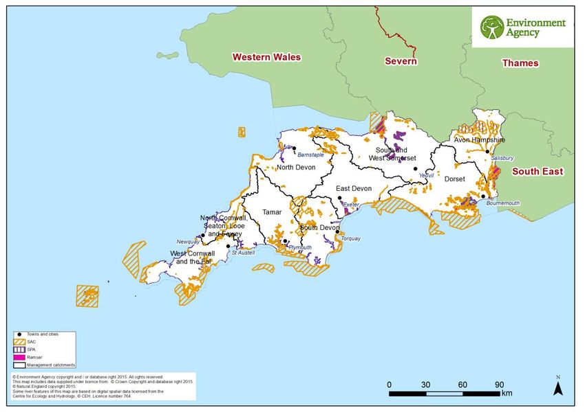
The HRA has been carried out for the set of measures for each RBD catchment that address
main river, sea and reservoir flooding alongside any measures volunteered by RMAs that
address local flooding and thus form a ‘RBD plan’ within the FRMP. There are no Flood Risk
Areas in the SW RBD that required separate consideration in the HRA. The findings are a
summary of the risks to European sites and an indication of the need for future HRAs at a
project level when developing local actions, as well as considering how to avoid and mitigate
any residual risks to European sites.
For the South West RBD FRMP, the main conclusions from the stages of assessment are as
follows:
A determination was made to screen out measures that would not have physical effects on
any European sites.
The effects of the measures from existing plans include effects of measures to address
coastal flooding from SMPs, measures to address main river flooding from CFMPs and
measures to address local flooding from local strategies. Existing controls and mitigation
from these plans include: for SMPs, development of coastal strategies, accompanied by
more detailed HRAs for relevant SMP Policy Areas, and for CFMPs and Local Strategies
more detailed appraisal and assessment on plans or projects arising out of the plans to
demonstrate meeting the requirements of the Conservation of Habitats and Species
Regulations 2010, as amended (Habitats Regulations).
The effects of the measures that are for new flood risk management priorities for the next
FRMP cycle period of 2015 to 2021 have been considered within this strategic-plan level
HRA as far as they can be assessed at this high level. This HRA considered the range of
mitigation options that may be applicable. It is concluded that the measures are expected to
be able to be avoided or mitigated as part of their development as local actions, and all
measures have been identified as capable of being fully mitigated. It can therefore be
concluded that at the plan level there is sufficient scope for ensuring no likely significant
effects during its implementation. The detail of the controls and mitigation required will be
assessed as part of requirements to meet consents under planning and other consenting
mechanisms as part of a project level HRA, some of which may need to proceed to
appropriate assessment in order to gather the necessary level of detail.
The HRA considers the potential for in-combination effects with other plans and projects.
Given the level of information currently available, the assessment has identified the plans
where the greatest risk of in-combination effects occur, but a detailed assessment can only
be undertaken at the project level when details of location and design of measures are
known. Key external plans to consider for in-combination effects are:
Local Plans – plans of local planning authorities to determine consent for proposed
developments including FCRM ‘Protection’ types of development and which require
HRA for developments affecting European Sites
Water Resource Management Plans – plans to manage the supply of water to
communities by Water Companies.
River Basin Management Plans – plans that seek to ensure the objectives of water
dependent European Sites are maintained.
3
Marine Plans – plans to manage the sustainable use of marine resources for inshore
areas.
This HRA does not remove the need for HRA at a subsequent level, i.e. lower tier strategies,
plans or projects that implement measures. This plan-level HRA does not give any weight to
subsequent lower-tier plans or projects and their HRA outcomes.
As local actions are developed at a project level and the details of their scope and scale are
known, this may identify additional effects on European sites that have not been assessed
here, or were not appropriate to consider at this spatial scale of plan.
4
CONTENTS

1     Introduction .................................................................................................................... 6
    1.1     Introducing this report ............................................................................................. 6
    1.2     Background to the FRMPs ...................................................................................... 7
    1.3     The South West RBD FRMP ................................................................................... 7
    1.4     Background to Habitats Regulations Assessment ................................................... 9
2     European sites in the South West RBD ........................................................................ 11
    2.1     European sites that could be affected by the FRMP.............................................. 13
    2.2     European sites and their status for FRMPs ........................................................... 13
    2.3     European sites and their management.................................................................. 15
3     Approach to the HRA ................................................................................................... 16
    3.1     Description of the FRMP programmes of measures .............................................. 16
    3.2     Screening and Likely Significant Effects................................................................ 16
    3.3     Screening out catchments where no European sites are present .......................... 17
    3.4     Screening out measures that would not have physical effects .............................. 17
    3.5     Considering measures from existing plans ............................................................ 18
    3.6     Considering new measures for FRMP cycle 1 ....................................................... 19
    3.7     Considering the need for further stages of assessment ........................................ 19
4     South West River Basin District Catchments HRA ....................................................... 20
    4.1     Summary of Measures .......................................................................................... 20
    4.2     Screening and Likely Significant Effects................................................................ 22
    4.3     Consideration of results and conclusion ................................................................ 66
5     In combination effects with other plans and projects .................................................... 70
    5.1     In-combination effects between RBD FRMPs ....................................................... 70
    5.2     In-combination effects with external plans ............................................................. 71
6     Conclusion and Future HRAs ....................................................................................... 73
Annex A              Table A1 – HRA screening table for the FRMP measure categories

                     Table A2 – Management catchments and European sites in the South West
                     RBD

                     Table A3 – Mitigation and control measures
Annex B              South West RBD European sites

                                                                   5
1 Introduction
1.1 Introducing this report
This report sets out the results of a strategic- plan level Habitat Regulations Assessment
(HRA) into the likely significant effects on designated ‘European sites’ of the Flood Risk
Management Plan (FRMP) for the South West River Basin District, published in December
2015. The HRA report has been prepared by the Environment Agency on behalf of the
collective Risk Management Authorities (RMAs) that have responsibilities for information
being published within the FRMP, and are thus the ‘competent authorities’ for the HRA of
their respective published information, as follows:
Information on flooding from main river, sea and reservoirs being published for the
catchments of the river basin district (RBD) are the responsibility of the Environment
Agency (for English catchments).
Information on flooding from local sources being published for any Flood Risk Area
(FRA) is the collective responsibility of Lead Local Flood Authorities within the FRA.
In preparing the HRA report the Environment Agency has consulted with Natural England
(for English catchments) and Natural Resources Wales (for Welsh catchments). The Lead
Local Flood Authorities in Flood Risk Areas are ‘competent authorities’ for HRA of their
FRMP information and have agreed that this report will meet their HRA requirements.
FRMPs are new strategic plans for implementing the Flood Risk Regulations 2009 and the
existing National Flood and Coastal Erosion Risk Management (FCERM) Strategy for
England. They have been developed for River Basin Districts (RBDs) and Floods Risk Areas
(FRAs) and draw together information from a range of existing strategies and plans that are
in place and continue to be maintained by Risk Management Authorities. The HRA has
been carried out at the level of detail published in the FRMP and takes into account HRAs
that have already been undertaken for measures in existing plans, and at the level of detail
provided by these existing plans. Whilst a HRA at this strategic level cannot obtain the level
of detail necessary for in-depth assessment, the HRA summarises the likely risks and
potential need for controls and mitigation and the range of generic mitigation options
available, which will then proceed through further consideration once measures are
developed as specific local actions. In this way, this high- level HRA will be helpful for future
HRAs that consider the effects on European sites at a project level.
The report describes each of the main stages and results of the FRMP HRA as follows:
Describing the network of European sites within the RBD (chapter 2)
The approach to the HRA (chapter 3)
Screening and assessing likely significant effects (chapter 4)
Appropriate assessment, alternative solutions and imperative reasons of overriding
public interest (IROPI) (chapter 4)
Conclusion and future HRAs (chapter 6)
61.2 Background to the FRMPs
Flood risk management plans (FRMPs) highlight the hazards and risks from rivers, the sea,
surface water, groundwater and reservoirs and set out how risk management authorities,
such as the Environment Agency and local authorities, will manage flood risk. They are
required by the European Union Floods Directive and the Flood Risk Regulations 2009. The
FRMPs must be reviewed and reissued every six years to describe progress.
The Environment Agency is required to prepare FRMPs for all of England covering flooding
from main rivers, the sea and reservoirs. Lead Local Flood Authorities (county councils and
unitary authorities) must prepare flood risk management plans for flood risk areas (there are
ten flood risk areas in England) where the risk of flooding from local sources is significant as
identified in Preliminary Flood Risk Assessments.
The 2015-2021 period will be the first cycle of the FRMPs, however RMAs already plan for
flooding and a large proportion of the FRMP measures are taken from existing plans that
have already been consulted on and published. This includes plans such as Catchment
Flood Management Plans (CFMPs) and Shoreline Management Plans (SMPs) as well as
Local Flood Risk Management Strategies that have been developed by local authorities.
Some further strategic developments have been included for the 2015-2021 first cycle of the
FRMP that build on existing plans and seek to address the key objectives of the Flood Risk
Regulations 2009, such as: strengthening joint working of RMAs, developing more integrated
management of the water environment, and updated priorities from any new understanding
of flood risks including the implications of climate change.
1.3 The South West RBD FRMP
The South West river basin district (RBD) includes Cornwall, Devon, Dorset and parts of
Somerset, Hampshire and Wiltshire. The Isles of Scilly and Lundy Island are also included
in the RBD. The RBD is predominantly rural and, with just over 5 million people living and
working in it, the area has the lowest population density of any English region. The principal
urban centres include Exeter, Plymouth, Torquay, Bournemouth and Poole. Tourism and
recreation makes a significant contribution to the economy of the South West and many of
its tourist destinations and activities are water related as, for example, associated with the
area’s beaches, harbours, estuaries and rivers such as the Avon, Camel and Axe. The
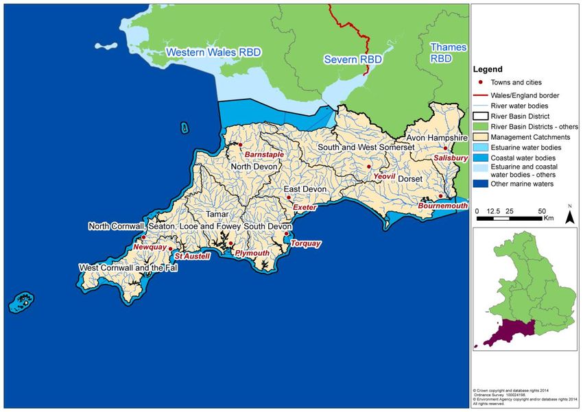
South West RBD is made up of 9 management catchments (see map in Figure 1 below).
The FRMP describes the scale of flood risk in the South West RBD. As a general summary
the RBD is susceptible to: rapid onset flooding in small steep sided impermeable
catchments; tide locking in lowland areas where water drains very slowly; delayed flooding in
chalk catchments; and coastal flooding. Flood risk is extremely diverse and the
management of flood risk is appropriate at a catchment level, for example:
The Devon and Cornwall peninsula is where weather systems from the Atlantic Ocean
first land and impact England. Small steep sided catchments respond quickly to rainfall.
While numbers of properties at risk may be relatively low compared with other areas of
the country, risk to life and community disruption from flooding is significant.
The uplands in Somerset generate quick run-off from short intense rainfall, but the
lowland areas are very flat. Rainfall run-off travels quickly from the uplands, but pools in
7the lowlands. Large areas are below sea level and tide locking is a particular feature of
the Somerset Levels and Moors where water drains very slowly.
Watercourses in the Hampshire Avon receive significant flows from chalk aquifers. At
the catchment scale these rivers react slowly to rainfall. Long periods of very wet
weather result in long periods of flooding.
For Cornwall, Scilly, Poole and Christchurch Bays, numbers of property at tidal flood risk
is set to increase threefold by 2105. Tidal flood risk will be the dominant flood risk in the
region.
There are at least 8 locations where numbers of property within the tidal flood risk zone
will increase by more than 1,000 properties by 2105. A further 9 communities will see
dramatic increases at a community level in the number of properties at tidal flood risk.
Climate change may lead to increasingly uncertain weather patterns with potential for
increased rainstorm intensities. Rising sea levels and potentially stormier conditions
increase flood risk and pressure on coastal defences. Wave and wind action may
increase flood risks to life and property, especially in the west of the region.
Communities will need to adapt to address both flood and erosion risk.
Figure 1 South West RBD catchments
The South West RBD FRMP sets out the objectives and measures that have been drawn by
risk management authorities from existing plans or newly developed for the FRMP cycle
period of 2015-2021. Existing measures in the South West RBD FRMP are derived from the
following source plans:
Shoreline Management Plans (SMPs)
Catchment Flood Management Plans (CFMPs)
Local Flood Risk Management Strategies (FRMS) developed by LLFAs.
8There are no Flood Risk Areas in the South West RBD. The FRMP hence comprises
measures within the 9 RBD catchments that the Environment Agency is responsible for as a
RMA covering flooding from main rivers, the sea and reservoirs.
1.4 Background to Habitats Regulations Assessment
In England and Wales, the Conservation of Habitats and Species Regulations 2010, as
amended, commonly termed the Habitats Regulations, implements the European Union
Habitats Directive (Directive (92/43/EEC) on the Conservation of natural habitats and of wild
flora and fauna, and certain elements of the Wild Birds Directive (2009/147/EC). This
legislation provides the legal framework for the protection of habitats and species of
European importance in England.
Sites protected under the Habitats Regulations comprise Special Protection Areas (SPA),
Special Areas of Conservation (SAC), candidate SACs (cSAC), Sites of Community
Importance (SCI) and, as a matter of government policy, to potential Special Protection
Areas (pSPA) and Ramsar sites (sites designated under the 1971 Ramsar Convention for
their internationally important wetlands). These sites are referred to collectively as in this
report as ‘European sites’.
Regulation 9(3) of the Habitats Regulations requires that a ‘competent authority’ must
consider the requirements of Habitats Directive in exercising any of its functions. Article 6(3)
of the Habitats Directive defines the requirements for assessment of plans and projects
potentially affecting European sites. This requires that a competent authority, before
deciding to undertake, or give any consent or authorisation for a plan or project which is
likely to have a significant effect on a European site, and is not directly connected with or
necessary to the management of that site, must carry out an appropriate assessment. The
term commonly referred to for the assessment process is ‘Habitats Regulations
Assessment’.
The South West FRMP is considered to fit within the definitions of a ‘plan’ as defined by the
Habitats Directive, and requires a Habitats Regulations Assessment (HRA). The FRMP is a
high-level planning document for the South West River Basin District (RBD) (see map in
Figure 1), therefore potential impacts of the plan on European sites across the RBD are
difficult to determine. Given the geographic scale and nature of the plan, the HRA has been
tailored to be appropriate for the spatial area of coverage and the strategic nature of the
plan.
The Habitats Regulations Assessment has followed a framework of four distinct stages, only
moving to the next stage if required by the results of that stage of the assessment. The four
stages are:
Stage 1: Screening and Likely Significant Effects is the process which initially identifies
the likely impacts upon a European Site of a plan or project, either alone or in combination
with other plans or projects, and considers whether these impacts may be significant. This
stage also includes the development of mitigation to avoid or reduce any possible effects.
Stage 2: Appropriate Assessment is the detailed consideration of the impact on the
integrity of the European Site of the plan or project, either alone or in combination with other
plans or projects, with respect to the site’s conservation objectives and its structure and
9function. This is to determine whether there is objective evidence that adverse effects on the
integrity of the site can be excluded. This stage also includes the development of mitigation
to avoid or reduce any possible effects.
Stage 3: Assessment of alternative solutions is the process which examines alternative
ways of achieving the objectives of the plan or project that would avoid adverse impacts on
the integrity of the European Site, should avoidance or mitigation be unable to avoid adverse
effects.
Stage 4: Assessment where no alternative solutions exist and where adverse effects
remain is made with regard to whether or not the plan or project is necessary for imperative
reasons of overriding public interest (IROPI) and, if so, of any required compensatory
measures.
102 European sites in the South West RBD
Within the South West RBD there are 58 SACs, 5 Sites of Community Importance (SCI), 14
SPAs in addition to one pSPA and 9 Ramsar sites. Some of the sites have more than one
designation such as Chesil Beach and the Fleet, parts of which are designated as SPA, SAC
and Ramsar.
Figure 2 - Map of the European sites in the South West River Basin District
The European Sites within the South West RBD encompass a wide diversity of habitat types,
with a notable concentration of coastal and marine sites. In addition to freshwater habitats
such as rivers, lakes and other wetlands, other frequently occurring habitat types within the
RBD are heathlands, woodlands and grasslands.
The 9 Ramsar sites within the RBD are represented by inland and coastal sites in near equal
proportion and are also designated as SPAs. Coastal sites include parts of the Severn
Estuary as well as Poole Harbour and the Exe Estuary in addition to the Isles of Scilly and
the shingle and lagoon habitats and species of Chesil Beach and the Fleet. The qualifying
features for these sites include the internationally important assemblages of breeding
seabirds associated with the Isles of Scilly and the overwintering and migratory assemblages
of wetland birds attracted to the Exe and Severn estuaries. Poole Harbour is the best and
largest example of a bar-built estuary in the UK and similarly supports internationally
important assemblages of waterfowl including avocet, shelduck and black-tailed godwit. The
lagoon characteristics and extensive intertidal mudflats of Poole Harbour also support
11nationally rare plant and invertebrate species as well as important populations of breeding
waterfowl, including common tern and Mediterranean gull.
Inland Ramsar/SPA sites include the Avon Valley and its chalk river system and associated
areas of floodplain grassland, as well as the complex of designated sites that comprise the
Dorset Heathlands. The Dorset Heathlands comprise extensive, but fragmented areas of wet
and dry heathland centred around the estuary of Poole Harbour and adjacent to the urban
conurbation of Bournemouth and Poole. The heathland areas support a large assemblage of
nationally rare and scarce species, especially invertebrates, as well as important populations
of heathland breeding birds such as nightjar, woodlark and Dartford warbler and
overwintering birds of prey such as hen harrier. The Somerset Levels and Moors
Ramsar/SPA is similarly represented by series of designated sites that cover extensive
areas of flood plain drained by a large network of ditches, rhynes, drains and rivers. The site
represents the largest area of lowland wet grassland and associated wetland habitat
remaining in the UK. The area attracts internationally important numbers and assemblages
of overwintering birds, such as Bewick’s swan, lapwing and teal, as well as representing one
of the most important sites in southern England for breeding waders together with supporting
diverse assemblages of aquatic invertebrates. The South West RBD also includes parts of
the extensive site of the New Forest and its intricate mosaic of habitats comprising streams,
ponds and other wetland habitats, dry and wet heathlands and grasslands and pasture
woodlands. These habitats, in turn, support rare and diverse assemblages of plants and
animals, particularly wetland invertebrate fauna and important breeding bird populations
such as Dartford warbler, woodlark and the European honey buzzard.
The SPAs within the RBD are equally represented by coastal and inland sites and as
highlighted above over half of the sites are also designated Ramsar sites. Additional inland
SPA sites that support important populations of overwintering and breeding birds include the
grasslands of Salisbury Plain, whilst sites that are of particular importance for their breeding
birds include the East Devon Heaths and Porton Down for species such as the Dartford
warbler, nightjar and stone curlew. Coastal SPA sites within the RBD range in size from
Marazion Marsh in Cornwall with its large expanse of reedbeds supporting important
populations of breeding, wintering and migratory birds to the Tamar Estuaries complex
which is of importance for overwintering populations of pied avocet and little egret.
Across the RBD there are slightly more inland SACS than coastal sites, although the area
also includes 5 SCIs that are of primary importance for their inshore and offshore reef
habitats such as the sites at Lizard Point, Studland to Portland and Lyme Bay to Torbay.
Some SACs are designated primarily due to the species they support. This includes sites
such as Crookhill Brick Pit and Holnest and their populations of great crested newts, the
chalkland flora of Fontmell & Melbury Downs and Prescombe Down and the bat populations
associated with former quarry sites, such as Beer Quarry and Caves, and woodlands such
as Brackett’s Coppice. Former mining sites in the RBD, such as the St Austell Clay Pits,
are designated for the important lower plant communities that have developed following the
cessation of mining works, whilst the River Camel is primarily designated for its protected
fish species and otter population.
Many of the sites with the RBD are designated SACs in respect of their qualifying habitats.
In addition to the river SACs of the Avon and the Axe, the RBD is characterised by a wide
12diversity of coastal habitats. These include designated lengths of coastal cliffs, such as The
Lizard, St Albans Head to Durlston Head, Isle of Portland to Studland Cliffs, Sidmouth Bay to
West Bay and the Tintagel-Marsland-Clovelly Coast. Other coastal habitats include the
estuarine and intertidal habitats associated with sites such as Plymouth Sound and
Estuaries and Fal & Helford and the varied dune habitats of sites such as Dawlish Warren,
Braunton Burrows, Penhale Dunes and the Dorset Heaths (Purbeck & Wareham) and
Studland Dunes. Lundy Island and the Isles of Scilly complex are designated as SACs for
their reef habitats, with the Isles of Scilly also designated for its extensive areas of
sandbanks and intertidal mudflats and sandflats. Other designated habitats represented in
the RBD include heathland, such as Dartmoor and Exmoor, the lowland heaths of Dorset
and East Devon, the chalk grasslands of Salisbury Plain and woodlands, such as the West
Dorset Alder Woods and Exmoor and Quantock Oakwoods. Sites with associated wetland
habitats range from the extensive network of sites comprising the Somerset Levels and
Moors to much smaller sites such as Crowdy Marsh on the edge of Bodmin Moor.
Annex B contains a summary of the European sites present within South West RBD. Table
A2 in Annex A presents a summary of the European sites present within the management
catchments of the South West RBD. In a number of cases European sites cross over the
boundary of two or more management catchments, therefore a number of European site
names / designations may appear against more than one management catchment.
2.1 European sites that could be affected by the FRMP
The South West FRMP is a long term plan for the water environment, which could potentially
affect both water dependent and non water-dependent European sites and their qualifying
features.
Water dependent European sites are classified as protected areas under the WFD; each
protected area European site has specific objectives to ensure their favourable conservation
status. Supporting measures within the South West River Basin Management Plan (RBMP)
should predominantly be beneficial for the conservation status of water dependent European
sites and the South West FRMP seeks to align with the objectives of the South West RBMP
wherever possible. Where feasible, FRMP measures that also aim to improve water body
status within the South West RBMP / RBD are identified.
It is not possible from the outset to rule out, at the RBD scale, any (water-dependent or non
water-dependent) European sites from being affected by the South West FRMP. The HRA
(in particular Sections 4.2) reviews the European sites by management catchment, and
determines whether any of the measures within the catchments are likely to lead to
significant effects on European sites.
2.2 European sites and their status for FRMPs
The South West RBMP provides summary information on the current status and baseline for
water-dependent European sites as part of its monitoring data.
European sites in England, with the occasional exception, are also designated as SSSIs.
Natural England monitors the conditions of SSSIs and their component units using six
reportable condition categories: favourable; unfavourable recovering; unfavourable no
change; unfavourable declining; part destroyed and destroyed.
13The current status of water-dependent European site protected areas for the South West
RBD is summarised in table 1 below. This gives the current area of water-dependent SSSI
units of European protected areas in different condition categories as currently recorded on
Natural England’s designated site data system. SSSI units underpin European protected
areas and Natural England only collects data at a SSSI unit level. When SSSI units are in
favourable condition, they are deemed to be meeting their conservation objectives.
The table shows that for the South West RBD, 44% of water-dependent SSSI units of
European protected area sites are currently not compliant with the condition requirements.
Table 1: Status of water-dependent European sites based on assessment of SSSIs
units for the South West RBD (Extract from Natural England databases August 2015)
Condition South West (ha)
Favourable 33,792
Destroyed / Part destroyed 34
Unfavourable declining 2,036
Unfavourable no change 2,053
Unfavourable recovering 22,612
Total Area Unfavourable 26,735
% Unfavourable 44
The generic pressures on such sites in the South West region include forestry and woodland
management and agricultural practices as, for example, levels of grazing and mowing
regimes. These pressures can affect the condition and diversity of habitats present within a
site as well as the particular species they support, such as the specialist plants,
invertebrates and breeding birds associated with the Dorset Heathlands. Pressures typically
linked to river and wetland sites, such as the Camel, Axe and Avon rivers include pollution
from discharges, diffuse pollution from agricultural runoff, siltation, abstraction, physical
modification, inappropriate weed control and weirs and structures, and invasive species.
These pressures can affect qualifying habitats in addition to the diversity of aquatic and
wetland plant and animal species, including qualifying fish species such as bullhead, Atlantic
salmon and sea and brook Lamprey. Estuary sites, such as Poole Harbour and Plymouth
Sound and the Tamar Estuaries Complex, are also subject to pressures from local fishery
activities and from coastal squeeze with the potential loss of intertidal habitats and
consequent impacts on the breeding and overwintering bird populations they support.
Pressures identified for other coastal habitats, such as the sea cliffs of the Lizard and the
dune habitats of Penhale, include invasive species and inappropriate coastal management
resulting in the loss of the characteristic habitats and species of these areas.
Inappropriate water levels are identified as a pressure for certain sites, such as the
Somerset Levels and Moors, because of importance of the area’s characteristic wetland
habitats in supporting overwintering and migratory birds. Peat extraction is another identified
pressure for this particular site as well as public access and the resulting disturbance to
wintering birds. Other pressures associated with public access/disturbance and affecting
14sites in the RBD include boating and fishing activities along the coastline of the Isles of Scilly
and illegal vehicle use in the Exmoor Heaths. More generally, pressures from new and
existing development activities are identified as affecting a wide range of sites across the
RBD. Air pollution from atmospheric nitrogen deposition is also widely highlighted as a
pressure, with the potential to harm characteristic habitats such as the dry heaths and Oak
woodlands of the South Dartmoor Woods.
2.3 European sites and their management
As part of a new strategic approach to managing all England’s European sites, new
measures needed to achieve favourable conservation status for all European sites in
England have been developed by Natural England. These are collectively referred to as Site
Improvement Plans (SIPs), and are being developed by the Improvement Programme for
England’s Natura 2000 sites (IPENS). The final publication of SIPs for all European sites in
England is due to be in July 2015. SIPs were published for all European sites in England in
20152.
The South West FRMP recognises SIPs include actions where flood risk management is
specifically a mechanism for their delivery. The following are the relevant SIPs for the South
West RBD:
Avon River and Valley
Braunton Burrows
Chesil Beach & The Fleet
Exe Dawlish
Poole Harbour
Portland-Studland & St Albans-Durlston
River Axe
River Camel
2
Site Improvement Plans for the South West River Basin District can be found on:
http://publications.naturalengland.org.uk/category/6287197783195648
153 Approach to the HRA
The steps we have undertaken to complete the HRA are as follows:
describe the plan and the measures proposed
screen and assess the likely significance of any effects on European Sites
consider need for further stages of assessment (i.e. appropriate assessment,
alternative solutions and IROPI)
determine a plan level conclusion
3.1 Description of the FRMP programmes of measures
There are no Flood Risk Areas in the South West RBD. The FRMP hence comprises
measures within the 9 RBD catchments that the Environment Agency is responsible for as a
RMA covering flooding from main rivers, the sea and reservoirs.
3.1.1 River Basin District Catchments
FRMPs for the River Basin District (RBD) are being published by the Environment Agency
(for English catchments) and Natural Resources Wales (NRW) (for Welsh catchments), and
are focused on measures principally to address flood sources from main river, the sea and
reservoirs. The measures have been divided into catchments based on the River Basin
Management Plans (where they are called ‘management catchments’).
Production of the FRMPs for the RBDs is the legal duty of the Environment Agency and
NRW. Where any voluntary information on local sources of flooding within RBD catchments
has been provided by LLFAs, these are published by joint agreement in the RBD FRMP.
The Environment Agency and NRW are also the competent authority under the Habitats
Regulations for the RBD FRMPs.
3.1.1 Flood Risk Areas
FRMPs for Flood Risk Areas (FRAs) are being published by the Lead Local Flood
Authorities (LLFAs) where the FRAs lie within their administrative boundaries. Production of
the FRMPs for the FRAs are the legal duty of the respective LLFAs. The LLFAs responsible
for the FRA FRMPs are also the competent authority under the Habitats Regulations.
3.1.1 Applying HRA
The HRA process has been applied to each catchment of the RBD. A final summary of
conclusions and recommendations for future HRAs is provided that also draws on a high-
level summary of the potential for in-combination effects of the FRMP with other key plans.
3.2 Screening and Likely Significant Effects
This first stage of the HRA process requires consideration of screening and likely significant
effects of measures on European Sites. The tasks undertaken to complete this are as
follows, and set out in more detail below:
screening out catchments where no European Sites are present
16 screening out measures that would not have physical effects
considering measures from existing plans, with mitigation / controls already agreed in
HRAs for any likely significant effects, or in some cases potential adverse effect on
site integrity
considering new measures and their likely significant effects, with mitigation / controls
where considered necessary
conclusion from screening and likely significant effects.
The results of these tasks for the South West RBD FRMP are provided in chapter 4.
3.3 Screening out catchments where no European sites are present
Where there are no European sites present in a catchment, it was determined that no further
consideration of measures in the catchment is required. Given the level of detail in the plan
where the FRMP measures are mainly strategic in nature and are not specific on their
precise location, there is insufficient details to consider downstream or down drift effects
beyond the catchment. However, such screening for cross-catchment effects will be a
requirement in assessing local plans and projects.
3.4 Screening out measures that would not have physical effects
Every measure included within the FRMP is categorised according to one of the following 4
categories, accompanied by an M-code:
Prevention (M2) - reducing the impacts of flooding through land use and
development policy, relocation of assets at risk, or measures to divert the hazard to
avoid harm.
Protection (M3) - protecting people from the risk of flooding; for example, by the
maintenance, refurbishment of existing defences or building new defences.
Preparedness (M4) - by taking actions that prepare people for flooding; for example,
by improving awareness of flood risk, or by providing warning and forecasting for
floods.
Recovery and review (M5) - supporting recovery after flooding has happened and
reviewing how things can be improved; for example, by improving the availability of
recovery services such as providing temporary accommodation.
Other (M6) – measures not fitting in to any of the above categories.
Further definitions of each of the measures are set out in the FRMP according to a second
tier of M-codes. For example, Prevention (M2) includes the second tier measure, M22, which
is defined as “Prevention, removal or relocation measure to remove receptors from flood
prone areas or to relocate receptors to areas of lower risk”. These measure definitions have
been used as the basis for the initial screening out of the measures that require no for further
consideration within the HRA.
The measure codes and their definitions are included as Table A1 (in Annex A to this
document). Measures under ‘Preparedness’ (M4) and ‘Recovery and review’ (M5) will not
result in development, demolition or changes of management ‘on the ground’ that could
17result in effects on European Sites. These were therefore screened out from any further
consideration. Similarly, under the ‘Prevention’ category (M2), only the removal or relocation
of receptors from flood prone areas could potentially affect European sites. The measures
that have been screened in to the assessment are set out below and have been highlighted
in Table A1:
M22 – Prevention – removal or relocation (category)
M3 – Protection – all sub-categories
M6 – Other – not yet defined.
3.5 Considering measures from existing plans
Risk Management Authorities have a range of plans in place for developing and
implementing measures related to flooding from main river (in Catchment Flood
Management Plans), to flooding from the sea (in Shoreline Management Plans) and related
to local sources of flooding (e.g. in Local Flood Risk Management Strategies). These plans
have been subject to HRA where relevant, and have reported on the effects on European
Sites consistent with the level of detail of the plans.
For this HRA, these existing HRAs have been used to summarise the effects of measures
from existing plans that are now set out under specific RBD catchments or FRAs. For many
RBD catchments and FRAs there are multiple existing plans covering the geographic area
but also some existing plans that are split across RBD catchments or FRAs. Nonetheless we
have separated out the ‘screened in’ measures from individual existing plans and referenced
the specific HRA results that apply to them.
The results from existing HRAs have considered the extent that they remain valid since they
were published. This has been done by checking the status of the relevant European sites
that were considered within the source plan’s HRA for any changes to site designations
since the date of the HRA publication. The criteria were agreed with Natural England and
comprised: whether there were any new / additional site designations, any changes in site
boundaries, changes in designated site features, or any significant changes in site
conditions.
The HRA results from Shoreline Management Plans are relatively recent with most
published between 2010 and 2011. The HRA results from Catchment Flood Management
Plans are a little older with most published between 2008 and 2010. The HRA results from
Local Flood Risk Management Strategies are the most recent with the first ones being
published around 2012 and most being published much more recently.
One of the main reasons for a likely change from when the effects of plan measures were
reported in HRAs is where there have been boundary changes to European sites or to the
scope of condition of the interest features of the sites i.e. specific habitats, species etc.
Where we have been advised that such changes have occurred and are significant then this
has triggered further consideration of the validity of the existing HRA results that we have
relied upon.
183.6 Considering new measures for FRMP cycle 1
In reviewing the range of measures across existing plans covering all sources of flooding,
Risk Management Authorities (RMAs) have taken the opportunity to put forward further
strategic developments for the next 6 year cycle of the FRMP. These ‘new measures’ focus
on: strengthening the joint working of RMAs across all flood sources; developing more
integrated management of the water environment as set out in the River Basin Management
Plans and other related plans; and updating flood risk information to help manage risks with
communities.
For this HRA we have reviewed the set of new measures that have been ‘screened in’ for
each catchment. As they are mostly ‘strategic’ measures without specific information on
location or the form of action that would be developed on the ground, we have considered a
range of factors that would give rise to any likely risks from this set of measures in a specific
catchment, which includes:
their general proximity in the catchment to European sites
whether they aim to address sources of flooding that are local, or main river or
related to the coast
the mix of types of new measures within the catchment denoted by their M-codes
(i.e. whether they are mainly maintenance, or channel works, or new solutions).
General proximity was considered by narrowing down the set of measures within a
catchment to those that were closer in general and more likely to be connected to European
sites by the hydrology of the catchment rather than applying specific buffer distances to
individual measures.
3.7 Considering the need for further stages of assessment
HRA steps were carried out for each RBD catchment of the RBD plan that is the
responsibility of the Environment Agency. Further HRA steps were carried out for each FRA
(by catchment) that is the responsibility of respective Lead Local Flood Authorities. The
determination for each catchment or FRA that there are no likely significant effects to
European sites, is based on the following assumptions:
that this HRA does not remove the need for HRA at a subsequent level, i.e. lower tier
strategies, plans or projects that implement measures, nor does it give any weight to
their outcomes. Consideration of potential impacts and options available to mitigate
for those impacts should assist, but not influence or constrain any lower-tier
assessments.
that as local actions are developed at a project level and the details of their scope
and scale are known, that this may identify additional effects on European Sites that
have not been assessed here, or were not appropriate to consider at this spatial
scale of plan.
194 South West River Basin District Catchments HRA
This chapter sets out the results of carrying out the HRA on the measures for the South
West RBD catchments that are for flooding from main river, sea and reservoirs and for local
flooding sources outside of Flood Risk Areas. This is the FRMP information for which the
Environment Agency is the FRMP ‘statutory authority’ and HRA ‘competent authority’.
This section covers the following stages of the assessment:
Summary of measures being assessed
Screening and assessment of likely significant effects
Consideration of results and conclusion
4.1 Summary of Measures
The initial screening and assessment of likely significant effects reviewed the measures for
each of the 9 management catchments within the South West draft FRMP.
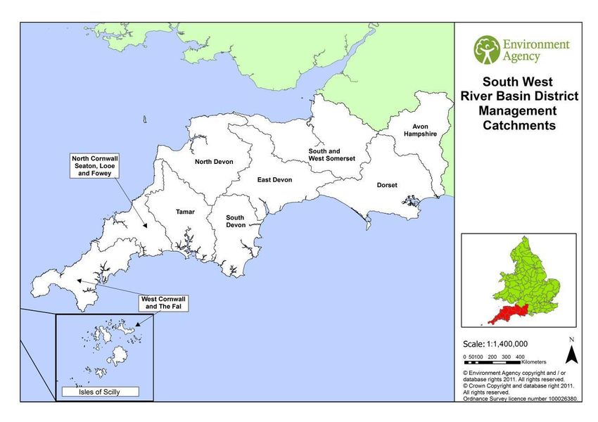
Figure 3 - Map of the South West river basin district and management catchments
A summary of the measures and their screening is given below for each catchment.
20Table 2: Summary of measures by catchment
Number of measures
Number of measures
Management Number of measures related to types of Number of new measures and
Number of European
from existing plans1
measures for cycle1
Catchment existing plans1 known level of detail1
screened in (out)
Number of new
Sites
Catchments with no screened in measures
All catchments have some screened in measures.
Catchments with all measures from existing plans
All catchments have new measures and from existing plans
Catchments with new measures for cycle 1 of the FRMP
South West 6 (16) 0 6 6 strategic/proximity unknown n/a
RBD Wide
40 20 17 from CFMPs 20 8 not in proximity 16
West (24) 3 from SMP 2 strategic/proximity unknown
Cornwall 10 specific/in proximity
and the Fal
North 28 18 16 CFMPs 10 2 not in proximity 7
Cornwall, (15) 2 from SMP 2 strategic/proximity unknown
Seaton, 6 specific/in proximity
Looe and
Fowey
Tamar 26 16 15 from CFMP 10 2 not in proximity 8
(17) 1 from SMP 3 strategic/proximity unknown
5 specific/in proximity
South 84 39 16 from CFMPs 45 15 not in proximity 6
Devon (61) 11 from SMP 10 strategic/proximity unknown
12 from LFRMS 20 specific/in proximity
North 60 34 21 from CFMPs 26 5 not in proximity 7
Devon (47) 3 SMP 6 strategic/proximity unknown
10 LFRMS 15 specific/in proximity
East Devon 93 48 19 from CFMPs 45 8 not in proximity 12
(57) 11 SMP 9 strategic/proximity unknown
18 LFRMS 28 specific/in proximity
South and 79 68 4 from CFMP 11 4 not in proximity 14
West (73) 45 from SMP 7 specific/in proximity
Somerset 18 LLFA
1 Multi agency plan
Dorset 24 21 18 from CFMP 3 3 specific/ in proximity 23
(31) 3 SMP
Avon 6 4 4 from CFMP 2 2 specific/in proximity 6
Hampshire (9)
Overall 446 268 130 from CFMPs 178 44 (6%)not in proximity
Total 79 from SMPs 39 (5%) strategic/proximity
(350) 58 from LLFAs unknown
1 from multi agency plan 96 (12%) specific/in proximity
% all 56% 34% 16% from CFMPs 22%
measures 10% from SMPs
7% from LFRMSOf the total of 796 measures 56% have been screened in for HRA consideration (44%
screened out). All management catchments within the South West RBD have some
screened in measures and are considered further.
There are 22 measures that are RBD-wide and are considered in section 4.2.4.1.
There are no measures from neighbouring river basin districts that are included in SW RBD
catchments.
4.1.1 Risks from existing plan measures
34% of all measures are screened in and from existing plans, of which 16% are from CFMPs
and 10% from SMPs. Most risks are from SMP measures where adverse effects identified in
the SMP HRA for specific policy areas are being addressed.
Most risks to European Sites that are being addressed by existing plans relate to the (10%)
measures in SMPs, and more specifically where the SMP is managing likely adverse effects,
such as in the catchments of South Devon, East Devon, South and West Somerset and
Dorset.
4.1.2 Risks from new measures
22% of all measures are screened in and new, of which 5% are strategic, 6% are not in
proximity to any European Sites and 12% are more specific improvements that are in
proximity to sites. The most likely risks will be related to the development of local actions for
the specific improvements in the next FRMP cycle. New measures can be found in all the
catchments, although with particular concentrations in the South Devon, North Devon, East
Devon and West Cornwall and the Fal catchments. The future strategic measures may also
present a risk depending on where they are implemented.
4.2 Screening and Likely Significant Effects
The management catchments that make up the South West RBD FRMP are set out in table
3 below. The colour coding in the table summarises the nature and source of the bundle of
measures, which forms the basis for how each management catchment has been assessed.
The following sub-sections consider each of the management catchments in turn.
Table 3 Management Catchments of the South West RBD /FRMP
Management Catchment Category Management Catchments
Management catchments with no None
European Sites present.
Management catchments with no None
‘screened in’ measures.
Management catchments with all None
measures from existing plans.
Management catchments with new West Cornwall and North Devon
measures. the Fal East Devon
North Cornwall, South and West
Seaton, Looe and Somerset
Fowey Dorset
Tamar Avon Hampshire
South Devon
224.2.1 Management catchments with no European sites present
All management catchments within the South West RBD have European sites present,
therefore no management catchments have been ruled out of further consideration on this
basis.
4.2.2 Management Catchments with no ‘screened in’ measures
All management catchments within the South West RBD have screened in measures,
therefore no management catchments have been ruled out of further consideration on this
basis.
4.2.3 Management Catchments with all measures from existing plans
There are no management catchments within the South West RBD with measures only from
existing plans.
4.2.4 Management Catchments with New Measures
4.2.4.1 South West River Basin District
European New measures Existing plan measures
sites
Screened in Screened out Screened in Screened out
See Figure 2
6 16 0 0
The South West FRMP includes 22 measures that apply to all the management catchments
within the South West RBD. All the new measures are from the Environment Agency as part
of the FRMP.
Of the new measures 6 are screened in for further consideration as they relate to flood
protection (M3) and 16 screened out as they relate to flood prevention (M21, M23, M24),
preparedness for flood events (M41, M42, M43, M44) and recovery and review (M53).
Half of the protection measures screened in for further consideration relate to natural flood
management / runoff and catchment management (M31) with the other measures referring
to channel, coastal and floodplain works (M33) and other protection (M35). At the scale of
the RBD the proposed measures do not specify particular locations and refer to general
opportunities such as: working with partners to encourage best farming practices; working
with Natural England and other partners to identify opportunities for floodplain restoration
and increasing storage in the upper catchment; and producing opportunity maps in support
of working with natural processes. Other RBD wide measures refer in general terms to the
review of System Asset Management Plans, securing funding and delivering emergency
works where needed and incorporating climate change allowances into flood risk
management works.
23Given the RBD wide context for these measures they are framed in general terms. The
FRMP does not constrain how or where measures are implemented. When the measures
are instigated, however, they will be subject to project level control through the relevant
consenting process and the associated requirement for consideration of project level HRA.
At this strategic plan level, a range of mitigation options have been identified (see Table A3,
Annex A). In light of the mitigation options available to adequately avoid or mitigate for
impacts, the measures are screened as not likely to lead to significant effect on
European sites. This is a plan-level conclusion and does not remove the need for lower-tier
HRA, nor does it influence the conclusions or specific need for appropriate assessment to
investigate mitigation options in more detail.
4.2.4.2 West Cornwall and the Fal Management Catchment
European New measures Existing plan measures
sites
Screened in Screened out Screened in Screened out
16 20 6 20 18
Within the West Cornwall and Fal management catchment there are 16 European sites
comprising 10 SACs and 2 SCIs; 2 SPAs3; 1 pSPA; and 1 Ramsar site4. The most extensive
of these sites are associated with the area’s coastline and include to the south of the
management catchment the Fal & Helford SAC, Lands End and Cape Bank SCI, Lizard
Point SCI and Falmouth Bay and St Austell Bay pSPA, in addition to the Isles of Scilly
SPA/Ramsar and Isles of Scilly Complex SAC. Along the north coast there is the Godrevy
Head to St Agnes SAC near to St Agnus and the Penhale Dunes SAC located north of
Perranporth. The Lizard SAC forms an extensive complex of sites south of Helston, whilst
other smaller discrete sites occur throughout the management catchment, such as Lower
Bostraze & Leswidden SAC near St Just, Marazion Marsh SPA to the west of Penzance,
Tregonning Hill SAC north of Porthleven and Carrine Common SAC south of Truro. In the
north of the catchment the Breney Common and Goss & Tregoss Moors SAC forms another
extensive complex of sites to the north of St Austell, this contrasting with the localised site of
the St Austell Clay Pits SAC.
In total there are 64 measures for the West Cornwall and the Fal management catchment.
The majority of these measures (38) are derived from existing plans, together with 26 new
measures as part of the FRMP.
New Measures
A total of 26 measures are proposed by the Environment Agency. Of these, 6 measures are
screened out as they relate to flood avoidance (M21), flood prevention (M24), flood warning
and forecasting (M41) and preparedness for flood events (M43). Twenty measures are
screened in as they relate to flood protection (M3). These measures comprise: 1 measure
3
http://publications.naturalengland.org.uk/publication/2745361
4
Isles of Scilly SPA/Ramsar; Breney Common and Goss & Tregoss Moors SAC; Lower Bostraze & Leswidden
SAC; St Austell Clay Pits SAC; Penhale Dunes SAC; Tregonning Hill SAC; Carrine Common SAC; Godrevy
Head to St Agnes SAC; The Lizard SAC; Fal & Helford SAC; Isles of Scilly Complex SAC; Marazion Marsh SPA;
Lands End and Cape Bank SCI; Lizard Point SCI; Falmouth Bay and St Austell Bay pSPA
24for water flow regulation (M32) and refers to the preparation of a Water Level Management
Plan for Marazion Marsh; and 19 measures for channel, coastal and floodplain works (M33).
Given the scope of the former measure, which is likely to support the conservation objectives
of the Marazion Marsh SPA and be subject to project level controls through the relevant
regulatory process, the measure is not considered further in the assessment. The measure
aligns with the SIP for the Marazion Marsh SPA and action 1A (Hydrological Changes) with
respect to developing and implementing a Water Level Management Plan for the site.
Two measures for channel, coastal and floodplain works (M33) are broadly defined and refer
in general terms to working with South West Water to better align investment by risk
management authorities and to working with partners to improve the flood resilience of
critical rail infrastructure in Cornwall. Overall, these measures seek to address flooding from
a range of sources including main river, ordinary watercourses and the sea as well as tackle
coastal erosion. The FRMP does not constrain how or where measures are implemented.
The above measures, however, will be subject to further investigation and appraisal. They
will also need to adhere to project level controls through the relevant consenting process and
the associated requirement for the consideration of project level HRA (see Table A3, Annex
A). This will enable the projects to be designed to avoid or adequately mitigate for any
adverse effects on European sites. The measures are therefore not likely to lead to
significant effect on European sites. This is a plan-level conclusion and does not remove
the need for lower-tier HRA, nor does it influence the conclusions or specific need for
appropriate assessment to investigate mitigation options in more detail.
Just under half of the measures (8) for channel, coastal and floodplain works (M33) are in
general locations that are some distance (over 5km to 10km) from the nearest European
site. The general areas where new measures are indicated include Copperhouse (near
Hayle), Gilberts Coombe (north of Redruth), Hayle, Ladock, Newlyn and Portreath. Most of
the measures are seeking to address flooding from main river, with a smaller number
seeking to address flooding from the sea as in the case of Newlyn, Hayle and Copperhouse
and additionally from main river and ordinary watercourses at Hayle. The precise nature of
the measures is not yet determined with the measures subject to further investigation and
appraisal. Overall, given the distances to designated sites, the measures are not likely to
lead to a significant effect on European sites. This is a plan-level conclusion and does
not remove the need for lower-tier HRA, nor does it influence the conclusions or specific
need for appropriate assessment to investigate mitigation options in more detail.
The remaining new measures (9) involving channel, coastal and floodplain works (M33) are
in general locations that are in closer proximity to European sites. These include:
Helston with The Lizard SAC and Fal & Helford SAC in the wider area;
Penzance with the Marazion Marsh SPA located approximately 3km along the coast;
Penryn with the Fal and Helford SAC and Falmouth Bay and St Austell Bay pSPA in
the vicinity;
Mevagissey and St Austell (3 measures) which are adjacent to the Falmouth Bay and
St Austell Bay pSPA;
Perranporth with the Penhale Dune SAC located immediately to the north; and
St Mawes which is directly adjacent to the extensive Fal & Helford SAC and
Falmouth Bay and St Austell Bay pSPA.
25You can also read