Waikato District Council - 2021 Addendum to the 2010 Pōkeno Catchment Management Plan
←
→
Page content transcription
If your browser does not render page correctly, please read the page content below
Project Number: 3-39332.00

Waikato District Council
2021 Addendum to the 2010 Pōkeno
Catchment Management Plan
25 June 2021
Contact Details

                  Rebecca Francis
                  WSP
                  Level 2, 160 Ward Street (Bryce Street
                  Entrance)
                  Private Bag 3057, Waikato Mail Centre
                  Hamilton 3240
                  +64 7 846 6536
                   +64 27 547 7412
                  Rebecca.francis@wsp.com

                  Document Details:
                  Date: 25 June 2021
                  Reference: 3-39332.00
                  Status: Final

                  Original Hydraulic Report by

                   Dorcas Adjei-Sasu – Senior Engineer

                  Addendum Prepared by

                   Courtenay Giles – Water Resources Engineer

                  Reviewed by

                  Alistair Allan – Work Group Manager (Water
                  Resources and Flood Risk Management

                  Approved for release by

                   Paul King – Head of Water (Hamilton)

©WSP New Zealand Limited 2021                                   i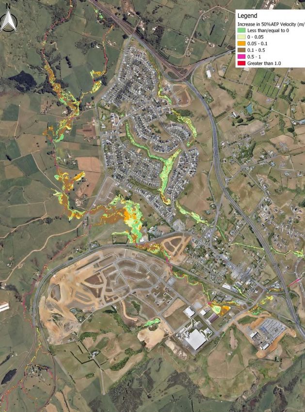
Document History and Status
Revision          Date            Author                Reviewed by      Approved by     Status
1              25/06/21    C Giles, D Adjei-Sasu       P King           P King         Final

Revision Details
    Revision                                               Details
1                 Addendum prepared from original hydraulic report

                                        ©WSP New Zealand Limited 2021                             ii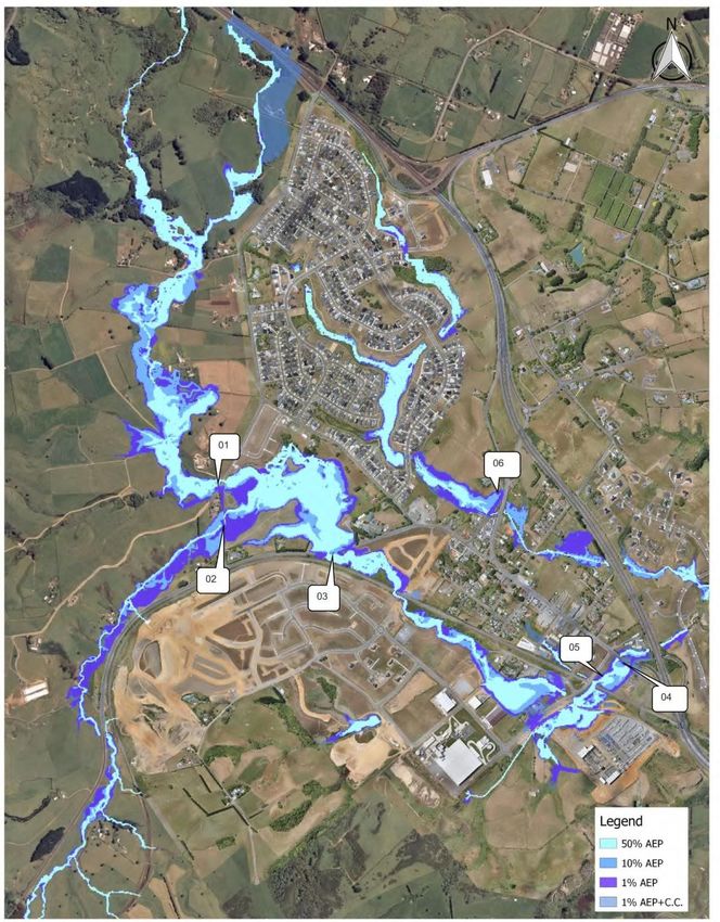
Contents
Disclaimers........................................................................................................................................................................................................................... 1

Foreword ................................................................................................................................................................................................................................ 1

Executive Summary .................................................................................................................................................................................................... 4

1            Introduction ........................................................................................................................................................................................................ 5
             1.1           Background ..........................................................................................................................................................................................5
             1.2           Purpose .....................................................................................................................................................................................................5

2            Strategic Planning Links ...........................................................................................................................................................................6
             2.1           Central and Regional Government Policies and Plans .................................................................................. 8
             2.2           Franklin District Council Policies and Plans ............................................................................................................. 8
             2.3           Proposed Pōkeno Structure Plan ...................................................................................................................................... 8

3            Catchment Description........................................................................................................................................................................... 12
             3.1           Catchment Overview .................................................................................................................................................................. 12
             3.2           Subcatchments ............................................................................................................................................................................... 13
             3.3           Catchment Boundary Assumption ................................................................................................................................ 13
             3.4           Previous Catchment Studies................................................................................................................................................ 13
             3.5           Landscape ............................................................................................................................................................................................ 13
             3.6           Soils and Geology........................................................................................................................................................................... 17
             3.7           Existing Land Use and Potential Contaminated Lands ................................................................................18
             3.8           Existing Stormwater Infrastructure ................................................................................................................................18
             3.9           Climate Change ..............................................................................................................................................................................18

4            Status of Receiving Environment ...................................................................................................................................................18

5            Stormwater Modelling .............................................................................................................................................................................18
             5.1           Hydrological Model ......................................................................................................................................................................19
             5.2           Selection of Hydrological Model Parameters ........................................................................................................19
             5.3           Data Sources ...................................................................................................................................................................................... 21
             5.4           HEC-HMS Model Calibration .............................................................................................................................................. 23
             5.5           Hydraulic Model ............................................................................................................................................................................. 23
             5.6           Selection of Hydraulic Model Parameters ............................................................................................................... 24
             5.7           TUFLOW Model Calibration ..................................................................................................................................................25
             5.8           Model Scenarios.............................................................................................................................................................................25
             5.9           Option Evaluation .........................................................................................................................................................................25
             5.10 Modelling Nodes .......................................................................................................................................................................... 26
             5.11          Pre-Development Model ....................................................................................................................................................... 26

                                                                                             ©WSP New Zealand Limited 2021                                                                                                              iii
5.12         Post-Development Model .................................................................................................................................................... 26
           5.13         Flood Plain Analysis and Flood Hazard Mapping ............................................................................................ 26
           5.14         Stream Erosion ................................................................................................................................................................................ 27
           5.15         Results and Discussion ............................................................................................................................................................ 30

6          Environmental Effects of Development ..................................................................................................................................36
           6.1          Environmental Implications ............................................................................................................................................... 36
           6.2          Likely Effects on Terrestrial Ecology ............................................................................................................................. 36
           6.3          Likely Effects on Aquatic Ecology .................................................................................................................................. 36
           6.4          Likely Effects of Stormwater Structures.................................................................................................................... 36
           6.5          Piping of Perennial Streams ............................................................................................................................................... 36

7          Consultation and Issues .........................................................................................................................................................................36

8          Stormwater Management Outcomes ....................................................................................................................................... 37
           8.1          Stormwater Management Philosophy ....................................................................................................................... 37
           8.2          Stormwater Quantity .................................................................................................................................................................. 41
           8.3          Stormwater Water Quality ..................................................................................................................................................... 41
           8.4          Climate Change .............................................................................................................................................................................. 41
           8.5          Infrastructure Upgrade Works ............................................................................................................................................ 41
           8.6          Riparian Planting .......................................................................................................................................................................... 47

9          Recommendations .................................................................................................................................................................................... 47
           9.1          Flooding Considerations ........................................................................................................................................................ 48
           9.2          Ecological Considerations .................................................................................................................................................... 50
           9.3          Erosion and Water Quality ..................................................................................................................................................... 51
           9.4          Climate Change .............................................................................................................................................................................53
           9.5          Land Development Rules ......................................................................................................................................................53
           9.6          Operation, Maintenance, and Monitoring Strategies ....................................................................................54
           9.7          District Council Implementation Plan ........................................................................................................................54

10         Limitations .........................................................................................................................................................................................................54

11         References .........................................................................................................................................................................................................54

Appendix A Flood Issue Areas .......................................................................................................................................................................55

Appendix B Flood Intervention Areas .....................................................................................................................................................63

                                                                                        ©WSP New Zealand Limited 2021                                                                                                          iv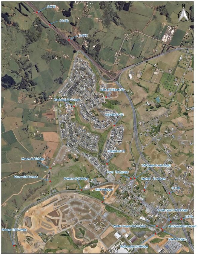
List of Figures
Figure 2-1: Existing future development zones and potential growth areas ............................................................. 9
Figure 2-2: Future proposed zones and future MPD area ....................................................................................................... 10
Figure 3-1: Subcatchment Delineation (Waikato District Council, 2020) .................................................................... 14
Figure 3-2: Existing Topography and Key Features (Waikato District Council, 2020) ....................................... 15
Figure 3-3: Land use and current locations of fill (Waikato District Council, 2020) ............................................16
Figure 3-4: Pōkeno Geology and Soils (Waikato District Council, 2020) ..................................................................... 17
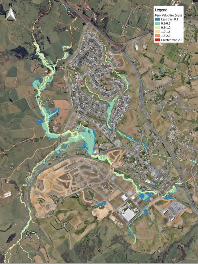
Figure 5-1: MPD 50% AEP velocities .......................................................................................................................................................... 28
Figure 5-2 50% MPD velocities compared to ED velocities: ................................................................................................ 29
Figure 5-3: 50%, 10%,1% and 1%+CC event Existing Flood Extents................................................................................... 31
Figure 5-4: Flood impacts as a result of no mitigation and MPD...................................................................................... 33
Figure 5-5: Mitigated MPD afflux results between existing development and proposed mitigated
development (70% attenuation of 1% AEP design flows) ....................................................................................................... 34
Figure 5-6: Flood depths as a result of mitigation (including attenuating 70% of greenfield runoff
rate).........................................................................................................................................................................................................................................35
Figure 8-1: Pōkeno Preferred Flood Risk Management Approach .................................................................................. 42
Figure 8-2: Catchments and proposed location of attenuation and conveyance ............................................. 43
Figure 8-3: Bridge and culvert locations ................................................................................................................................................ 46
List of Tables
Table 1-1: Key for Table 1-2........................................................................................................................................................................................ 1
Table 1-2: 2021 Addendum summary table ............................................................................................................................................ 2
Table 2-1: Land use changes that are likely to occur within the Pōkeno Catchment ....................................... 11
Table 2-2: Sequencing of preferred option measures .................................................................................................................. 11
Table 5-1: HIRDS (V3) Design Rainfall Depths (mm) ......................................................................................................................19
Table 5-2: Soil Types & CN Values ................................................................................................................................................................ 20
Table 5-3: Impervious Percentages ............................................................................................................................................................ 20
Table 5-4: Data available for modelling ................................................................................................................................................... 21
Table 5-5: Validation of subcatchment flows ..................................................................................................................................... 23
Table 5-6: Adopted hydraulic model roughness values ...........................................................................................................25
Table 5-7: Erosion Issues in the Pōkeno Catchment .................................................................................................................... 27
Table 5-8: Description of issues highlighted in Figure 7 .......................................................................................................... 30
Table 8-1: PPS 25 (UK) Flood Risk Management Hierarchy .................................................................................................... 37
Table 8-2: Potential Stormwater Management Approaches in the Pōkeno catchment ............................ 38
Table 8-3: Indicative attenuation volumes per sub-catchment......................................................................................... 44
Table 8-4: Culvert and bridge level summary service .................................................................................................................45
Table 9-1: Summary of mitigation requirements ............................................................................................................................ 47
Table 9-2: Flood Risk Development Requirements ..................................................................................................................... 48
Table 9-3: Stream Protection Requirements for Development .......................................................................................... 51
Table 9-4: Erosion Requirements for Development .....................................................................................................................52
Table 9-5: Water Quality Requirements for Developments...................................................................................................53
©WSP New Zealand Limited 2021 v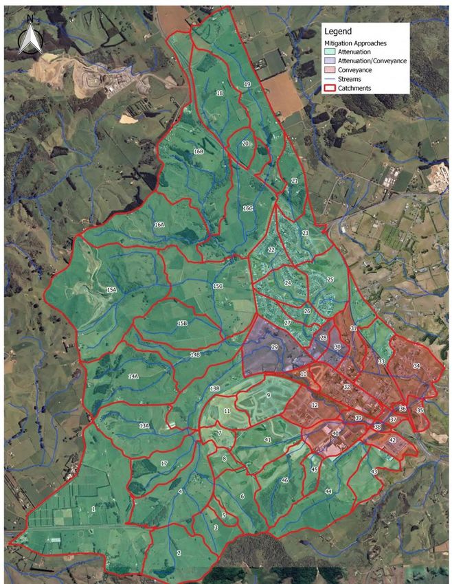
Project Number: 3-39332.00
Waikato District Council
2021 Addendum to the 2010 Pōkeno Catchment Management Plan

Disclaimers
This report (‘Report’) has been prepared by WSP exclusively for Waikato District Council (‘Client’) in
relation to an addendum to update the Pōkeno CMP (‘Purpose’). The findings in this Report are
based on and are subject to the assumptions specified in the Report, ‘Franklin District Council –
Pōkeno Stormwater Catchment Management Plan – September 2010 (FDC Ref D450/06) and
‘Waikato District Council – Pōkeno Catchment Management Plan (2020 Update) – February 2020’.
WSP accepts no liability whatsoever for any reliance on or use of this Report, in whole or in part, for
any use or purpose other than the Purpose, or any use or reliance on the Report by any third party.

The modelling work undertaken does not include a detailed model of the existing urbanized
catchment areas and their associated piped networks and overland flows. These internal
subcatchments flows are calculated and inserted into the model as specific locations to provide a
reasonable representation of the watercourses flooding. As such, the flood levels cannot be
considered for detailed design or finished floor level determination within the urbanised
subcatchments area as these areas may have other contributing (localised) factors that are not
considered in the overall catchment flood risk assessment.

It is the requirement of any consent applicant to provide an assessment of the effects upstream
and downstream of any proposed development. This addendum and associated modelling should
be used as an initial indication of potential flood issues. The modelling results may also be used as
inputs for a more detailed and localised flood model to suit individual development requirements.

Foreword
This addendum is to be read in conjunction with the ‘Franklin District Council – Pōkeno
Stormwater Catchment Management Plan – September 2010 (FDC Ref D450/06)’.

Table 1-1 describes the four different actions used to update this addendum. Table 1-2 summarises
the sections of this addendum in relation to the 2010 CMP and the action undertaken.

Table 1-1: Key for Table 1-2

 Action            Description

 New               Section is new to be read in conjunction with the 2010 CMP

 Additional        Section is to be read in conjunction with the matching CMP section

 Replaced          Section replaces the equivalent section of the 2010 CMP

 Deleted           Section is no longer relevant and the equivalent section in the 2010 CMP
                   should be disregarded

                                         ©WSP New Zealand Limited 2021                                    1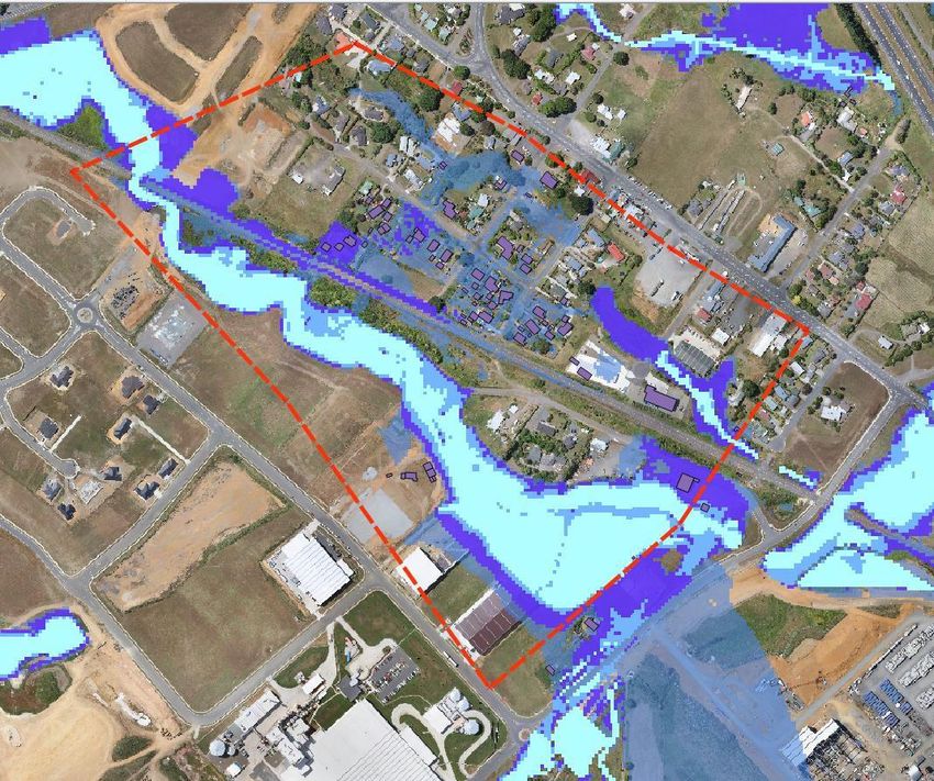
Project Number: 3-39332.00
Waikato District Council
2021 Addendum to the 2010 Pōkeno Catchment Management Plan

Table 1-2: 2021 Addendum summary table

 Section                                                                 Action

 1.1 – Background                                                            Additional

 1.2 – Purpose                                                               Additional

 2.0 – Strategic Planning Links                                              Additional

 2.1 – Central and Regional Government Policies and Plans                   No Changes

 2.2 – Franklin District Council Policies and Plans                         No Changes

 2.3 - Proposed Pōkeno Structure Plan                                        Additional

 3.0 – Catchment Description                                                 Additional

 3.1 – Catchment Overview                                                    Replaced

 3.2 – Subcatchments                                                         Replaced

 3.3 – Catchment Boundary Assumption                                          Deleted

 3.4 – Previous Catchment Studies                                           No Changes

 3.5 – Landscape                                                             Additional

 3.6 – Soils and Geology                                                     Replaced

 3.7 – Existing Land Use and Potential Contaminated Lands                   No Changes

 3.8 – Existing Stormwater Infrastructure                                   No Changes

 3.9 – Climate Change                                                        Additional

 4.0 – Status of Receiving Environment                                      No Changes

 5.0 – Stormwater Modelling                                                  Replaced

 5.1 – Hydrological Model                                                    Replaced

 5.2 – Selection of Hydrological Model Parameters                            Replaced

 5.3 – Data Sources                                                          Replaced

 5.4 – HEC-HMS Model Calibration                                             Replaced

 5.5 – Hydraulic Model                                                       Replaced

 5.6 – Sectional of Hydraulic Model Parameters                               Replaced

 5.7 – TUFLOW Model Calibration                                              Replaced

 5.8 – Model Scenarios                                                       Replaced

 5.9 – Option Evaluation                                                     Replaced

 5.10 – Modelling Nodes                                                       Deleted

 5.11 – Pre-Development Model                                                Replaced

                                         ©WSP New Zealand Limited 2021                    2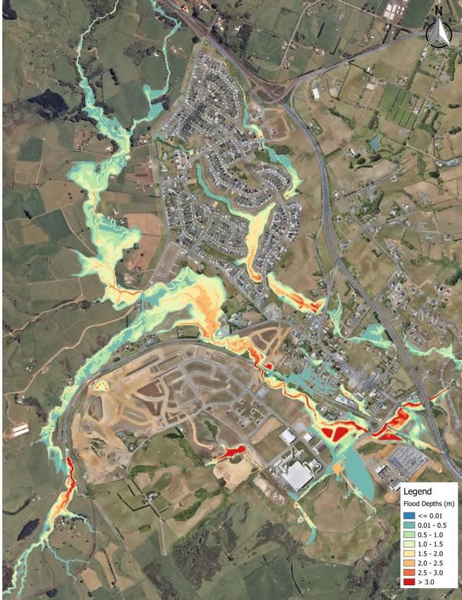
Project Number: 3-39332.00
Waikato District Council
2021 Addendum to the 2010 Pōkeno Catchment Management Plan

 5.12 – Post-Development Model                                              Replaced

 5.13 – Flood Plain Analysis and Flood Hazard Mapping                      Additional

 5.14 – Stream Erosion                                                     Additional

 5.15 – Results and Discussion                                              Replaced

 6.0 – Environmental Effect of Development                                 Additional

 6.1 – Environmental Implications                                          Additional

 6.2 – Likely Effects on Terrestrial Ecology                               No Changes

 6.3 – Likely Effects on Aquatic Ecology                                   No Changes

 6.4 – Likely Effects of Stormwater Structures                             No Changes

 6.5 – Piping of Perennial Streams                                         No Changes

 7.0 – Consultations and Issues                                            No Changes

 8.0 – Stormwater Management Outcomes                                      Additional

 8.1 – Stormwater Management Philosophy                                    Additional

 8.2 – Stormwater Quantity                                                  Deleted

 8.3 – Stormwater Water Quality                                            Additional

 8.4 – Climate Change                                                       Deleted

 8.5 – Infrastructure Upgrade Works                                         Replaced

 8.6 – Riparian Planting                                                   Additional

 9.0 - Recommendation                                                       Replaced

 9.1 – Flooding Considerations                                             Additional

 9.2 – Ecological Considerations                                           Additional

 9.3 – Erosion and Water Quality                                           Additional

 9.4 – Climate Change                                                       Replaced

 9.5 – Land Development Rules                                               Replaced

 9.6 – Operation, Maintenance and Monitoring Strategies                    No Changes

 9.7 – District Council Implementation Plan                                No Changes

 10.0 - Limitations                                                        Additional

This addendum is focused on flood risk management, recognising a significantly improved tool
(the Pōkeno Flood model) is available to support catchment management decisions.

                                           ©WSP New Zealand Limited 2021                       3
Project Number: 3-39332.00
Waikato District Council
2021 Addendum to the 2010 Pōkeno Catchment Management Plan

Executive Summary
This addendum is an update of the hydraulic analysis portion of the Pōkeno Stormwater CMP prepared by
Franklin District Council in 2010. This addendum has been prepared to support stormwater decision
making in Pōkeno. WDC identified that stormwater flooding represents a key constraint to development
within the Pōkeno Catchment. As such, the focus of this update has therefore been on flood risk
management, recognising the significant step forward WDC have made in the development of hydraulic
modelling for streams in the catchments. This
provides:
    1. A waterways assessment and Low Impact
        Design (LID) assessment.
    2. Guidance measures to address
        development and reduce existing issues.
The major outcome of the flood model was that
there were significant increases (100mm to
400mm) in flood levels for the 1% AEP event
between the pre-development flood model and the
current development flood levels indicating a
worsening of flooding due to development. This
modelling indicated that stormwater flooding
represented key constraint to development within
the Pōkeno Catchment, thus a flood management
plan for the whole catchment was needed.

The primary objective of this addendum is to
provide evidence-based guidance on the necessary
stormwater measures that need to be delivered by
development, as well as associated off-site
infrastructure improvements (e.g. downstream
capacity improvements).

Stormwater Management in Pōkeno
There are existing stormwater management
issues in Pōkeno – inundation of key transport
infrastructure, stream erosion leading to sediment
transport and loss of habitat, and the potential for
low water quality. These issues will be exacerbated
through development and climate change if not
appropriately addressed. The change in approach in the Waikato from simply mitigating, to also enhancing
(“net improvement”) through best practicable options (BPO), has led to the following catchment
management approach for Pōkeno:
     1.   To deliver environmental enhancement through growth by mitigating the effects of development.
     2.   Provide on-site attenuation to 70% of existing greenfield runoff rates to assist with flood
          management in Pōkeno.
     3.   Undertaking and allowing for:
             a. Upgrading of key transport infrastructure (bridges and culverts) crossing streams, in some
                 cases including additional ‘strategic’ attenuation;
             b. Applying low impact design (LID) in the industrial area to deliver enhanced streams;
             c. Delivering stream enhancements as part of the Pōkeno Sports Park development;
             d. Filling in discrete sections of the floodplain in Pōkeno town to unlock development and
                 deliver sustainable development.
It is important to note that stormwater treatment/detention facilities should be in place prior to upstream
impervious services being constructed. Floodplain modifications in the industrial area need to start with
removing restrictions prior to filling taking place.
Preliminary sequencing has been done but this will need to be considered further as will depend on
development areas and staging. Development specific flowpath widths and device requirements will need
to be reassessed at the time of subdivision. In most cases constructability constraints impose capacity limits
on the size of measures, rather than seeking a specific level of service

                                         ©WSP New Zealand Limited 2021                              4
Project Number: 3-39332.00
Waikato District Council
2021 Addendum to the 2010 Pōkeno Catchment Management Plan
1 Introduction
This section is to be read in conjunction with the 2010 CMP (Franklin District Council, 2010)
1.1 Background
The WDC vision for the Pōkeno catchment is:
“To achieve a sustainable community in the broadest sense. A sustainable community reflects
managing and protecting natural and physical resources in a way that enables communities to
develop economically, socially and culturally – while safeguarding the life supporting capacity of
air, water, and ecosystems. A sustainable community must also consider not only the health and
wellbeing of the community but also the needs of future generations”
The purpose of this addendum is to:
• Be used in conjunction with the 2010 CMP to update or supersede information;
• Give effect to the objectives and principals outlined in the 2010 CMP and 2020 CMP
Update;
• Provide a clear implementation path to address stormwater issues;
• Investigate and describe the stormwater issues, constraints, hazards and opportunities to
inform and set stormwater management practices needed within the Pōkeno Catchment;
• Set out concept designs for core stormwater infrastructure that will be end user, operated
and controlled by WDC;
• Support stormwater resource consent applications (current and future);
• Provide a clear framework for ongoing stormwater management within catchments
covered;
• Provide a clear understanding of flood risk and the impacts of recent development
proposals including the Pōkeno Sports Park; and
• Implement a Maximum Probable Development flood model that can be utilised for
development and remediation and provides a conservative flood boundary for future
assessments.
In some cases, data from the 2010 Stormwater Catchment Plan has been repeated in this
addendum to provide an easier to read document.
This addendum has been developed to support and manage growth in Pōkeno. This addendum
section numbering aligns with the 2010 CMP for an easy to interpret document. Please refer to
Table 1-2 for guidance.
1.2 Purpose
The addendum has been used to inform the Waikato District Council of the overall flood risk of
Pōkeno’s greater urban catchment area. This addendum assessed flood risks focussed on the main
waterways through the urban area. This enabled a systematic solution to be outlined and
implemented in the Long-Term Plan (LTP). This will enable further development without
significantly increasing the flood risk to the greater urban catchment.
It is intended that the implementation of the CMP along with this addendum will result in a range
of stormwater management activities being applied, including land use planning, development
controls, stormwater asset and system design, construction guidance, operation and maintenance.
©WSP New Zealand Limited 2021 5Project Number: 3-39332.00
Waikato District Council
2021 Addendum to the 2010 Pōkeno Catchment Management Plan
The list below highlights key stormwater management objectives sought for the Pōkeno
Catchment:
• Provide value for money.
• Consider ‘whole of life’ of the assets and catchment.
• Provide stormwater systems that manage hazard and are safe to operate and
maintain.
• Minimise the release of contaminants in waterways.
• Reduce scour and culvert washout from high energy flow.
• Reduce effect on the groundwater table and baseflows.
• Provide effective management of runoff volumes and flood levels in streams.
• Maintain or enhance ecological values.
• Stormwater is integrated into other land uses and values so that development can be
maximised.
• Be inclusive of community and other stakeholders.
2 Strategic Planning Links
This section supersedes Section 2 of the 2010 CMP.
There are several statutory documents that have been used to inform this addendum. These are
listed below with the relevant requirements from each document.
• National Policy Statement for Fresh Water Management 2017 1
• Considering and recognising Te Mana o Te Wai in freshwater management
• An integrated approach to managing land use and freshwater
• Safeguarding freshwater’s life supporting capacity, ecosystem and processes
• Protecting significant freshwater values
• Waikato Regional Policy Statement 2016 and the Waikato Regional Plan 2012
• Restoring the health and wellbeing of Waikato Rivers
• Development consent conditions to manage stormwater using a whole of
catchment approach and consider low impact design (LID)
• Avoid as far as practicable adverse effects on natural hydrological characteristics
and processes, soil stability, water quality and aquatic ecosystems
• Adopting sustainable technologies
• Maintaining or enhancing water quality by reducing sediment that derives from
the manmade activities
• Promotion of land-based stormwater mitigation
• The requirements of territorial authorities to manage the effects of subdivision,
use and development by promoting best practice stormwater development
• Considering alternatives to direct discharge of stormwater
• Operative Waikato District Plan, 2017 (Waikato District Council, 2017)
• The need for integrated design to make the most effective use of land resources
1
It is acknowledged that the National Policy Statement for Freshwater Management is out of date, this will be updated
when the report is next revised
©WSP New Zealand Limited 2021 6Project Number: 3-39332.00
Waikato District Council
2021 Addendum to the 2010 Pōkeno Catchment Management Plan
• Use or development of land subject to significant natural hazard should be
avoided. Where use cannot be avoided, mitigation of risks to health, safety and
property should be undertaken
• Development or protection of land should not increase the adverse effects of
natural hazards or compromise natural processes.
• Development should be designed and located to avoid or mitigate the predicted
effects of global climate change on natural hazards, particularly increased
flooding, erosion, and storms. Where there is incomplete information, a
precautionary approach should be taken.
• Development should minimise impervious surfaces, provide adequate
stormwater drainage, and mitigate the off-site effects of stormwater drained
from the site.
• The density and type of development should not exceed the capacity of the area
to absorb the adverse effects of the development on amenity, water quality,
stormwater runoff, ecological values, health or safety.
• Changes to hydrology (including low and high flows, and groundwater levels),
increased release of sediments and the discharge of contaminants shall be
avoided.
• Riparian areas shall be retained and enhanced. The incorporation of an
ecological corridor and reserves will result in them being enhanced as amenity
features of high ecological value.
• Large-scale earthworks shall be avoided to ensure that the natural features of the
area are retained, and hydrological characteristics are not substantially modified.
Low impact stormwater management is to commence on site to ensure that
natural water bodies are protected.
• Vision and Strategy for the Waikato River and Waikato Regional Plan Change I (Healthy
Waters, 2018)
• Restoration and protection of the health and wellbeing of the Waikato River.
• Restoration and protection of the relationship of the Waikato-Tainui with the
Waikato River, including the economic, social, cultural and spiritual relationships.
• The integrated, holistic and coordinated approach to the management of the
natural, physical, cultural and historic of the Waikato River.
• The recondition and avoidance of cumulative effects within the Waikato River
catchments.
• The restoration of the water quality in the Waikato River so that it is safe for
people to swim and take food from the river itself.
• Pōkeno Discharge Consent, 2008
• Divert and discharge urban stormwater runoff and associated contaminants at
multiple locations to land, the Tanitewhiora Stream, Helenslee Stream, and use
discharge structures in the general vicinity of Pōkeno Urban Area that are
reticulated by the Pōkeno municipal stormwater system.
• Implementing Best Practicable Option’s (BPO) to minimise actual or potential
adverse effects on the receiving environment.
• The need to remedy adverse scour and erosion effects.
• Reasonably minimise potential adverse flooding effects to land and property.
• No more than minor adverse effects on aquatic ecosystems.
• Monitoring and reporting programme that considers visual signs of
contaminants, scour and erosion effects, flooding, fish barriers, condition,
cleaning and illegal wastewater/trade waste connections.
• Identifying the existing flooding situation (baseline) and potential changes as a
result of growth forms a key part of this updated CMP. At present only past
©WSP New Zealand Limited 2021 7Project Number: 3-39332.00
Waikato District Council
2021 Addendum to the 2010 Pōkeno Catchment Management Plan
assessment undertaken from 2008 are available to determine the baseline
condition of water quality and erosion within the catchment. No data collection
is available since this time to understand how the receiving environment has
changed and to inform a reporting programme.
• Stormwater Management Plans and CMPs are identified in the WDC Consent
Evaluation Report as the key tools to both support new comprehensive
stormwater discharge consents and co-ordinate catchment-specific
requirements associated with a consent.
• Future Stormwater Consenting Framework (based on HCC new comprehensive consents
2018)
WDC will need to apply for a new comprehensive stormwater discharge consent by 2028. Waikato
Regional Council have been advised the 2012 Hamilton Urban Area (application no. 105279)
discharge consent provides an indication of the requirements that Pōkeno may expect moving
forward. This advice may change as further consents in the region are issued.
• CMPs (i.e. this document and future updates) are a prerequisite to new diversion
and discharge activities in the catchment.
• Some conditions remain similar to the existing Pōkeno consent (108592) such as
the need to address adverse scour, erosion and sedimentation, flooding, effects
to aquatic ecosystems, fish passage, illicit connections, etc.
• Refinements or nuances in condition wording and measure can be expected,
however the intent is expected to remain similar.
• The promotion of LID measures will be required.
• Establishment of a Stormwater Steering Group involve iwi representatives.
2.1 Central and Regional Government Policies and Plans
The documents listed in Section 2.0 have been used to update this addendum. Please refer to
Section 2.1 of ‘Franklin District Council – Pōkeno Stormwater Catchment Management Plan –
September 2010 (FDC Ref D450/06)’ for guidance on documentation used to inform the 2010
CMP.
2.2 Franklin District Council Policies and Plans
The documents listed in Section 2.0 have been used to update this addendum. Please refer to
Section 2.2 of ‘Franklin District Council – Pōkeno Stormwater Catchment Management Plan –
September 2010 (FDC Ref D450/06)’ for guidance on documentation used to inform the 2010
CMP.
2.3 Proposed Pōkeno Structure Plan
2.3.1 Background and Key Socio-Economic Objectives
No amendments to this section please refer to ‘Franklin District Council – Pōkeno Stormwater
Catchment Management Plan – September 2010 (FDC Ref D450/06)’ Section 2.3.1 for guidance.
2.3.2 Structure Plan Layout
This section supersedes Section 2.3.2 of the 2010 CMP.
The development area is considered as 9 future land use zones. The future zones are:
• Business;
• Business Town Centre;
• Heavy Industrial;
• Industrial;
©WSP New Zealand Limited 2021 8Project Number: 3-39332.00
Waikato District Council
2021 Addendum to the 2010 Pōkeno Catchment Management Plan
• Reserve;
• Residential;
• Road;
• Rural; and
• Village
These future zoned (as identified in the proposed district plan) and potential entire developable
catchment is shown in Figure 2-1.
Figure 2-1: Existing future development zones and potential growth areas
©WSP New Zealand Limited 2021 9Project Number: 3-39332.00
Waikato District Council
2021 Addendum to the 2010 Pōkeno Catchment Management Plan
2.3.3 Proposed Land Use Changes
This section supersedes Section 2.3.3 of the 2010 CMP.
The proposed development area is expected to convert rural land to predominantly urban
residential use with some green space/reserve areas as well as some industrial and heavy industrial
zones. The entire upstream catchment for Pōkeno (currently zoned rural) is expected to be
developed with an average impervious land cover of 65%.
It is noted that some floodplain infill and flattening of upper catchments will occur. These aspects
have not been included in any modelling (apart from changes in time of concentration) due to
uncertainty. Future land use changes that have been planned for by this CMP are represented in
Figure 2-2.
Figure 2-2: Future proposed zones and future MPD area
©WSP New Zealand Limited 2021 10Project Number: 3-39332.00
Waikato District Council
2021 Addendum to the 2010 Pōkeno Catchment Management Plan
Draft Waikato 2070 population figures and the MPD scenario has indicated that the following
(Table 2-1) development and land use changes are likely occur within the Pōkeno Catchment.
Table 2-1: Land use changes that are likely to occur within the Pōkeno Catchment
Location 1-3 years 3-10 years 10-30 years >30 years (MPD)
Munro Block East Munro Middle Munro Remaining
Residential N/A
Block Block Munro Block
Hitchen Block Remaining
Hitchen West
Residential N/A N/A Hitchen Block
Block
Catchments
Pōkeno Road
(West) N/A N/A N/A Pōkeno Road
Residential
Pōkeno East Pōkeno
Commercial N/A N/A Commercial (Out N/A
of Catchment)
Pōkeno East Pōkeno
Residential N/A N/A Commercial (Out Pōkeno Infill
of Catchment)
Pōkeno Town
Remaining Town
Centre Infill N/A Town Centre N/A
Centre Infill
Development
Hillpark Drive
Townhouse Hillpark Drive
Residential
Should flood mitigation works not occur in the catchment, flooding will increase as demonstrated
in Figure 5-4. Detailed outputs are provided in Appendix A.
2.3.4 Proposed Staging of Land Development
This section supersedes Section 2.3.4 of the 2010 CMP.
Table 2-2 identifies the broad sequencing of the preferred land development options in the
catchment. Once there is a clearer picture of where and when development might occur in the
catchment this sequencing can be refined and updated in conjunction with development plans.
Further investigation of erosion and water quality may introduce additional works or alter the
priority.
Table 2-2: Sequencing of preferred option measures
Order Intervention Comment
1 Great South Road No constraints to it being done first.
bridge
Required prior to Pōkeno Road bridge improvements to cater
improvements
for additional flows.
2 Ford Street Required prior to development in Pōkeno town so effects of
floodplain filling downstream is minimised.
3 Pōkeno Sports Park No constraints to it being done first.
Stream improvement works required prior to upstream
development due to likely residual erosion effects.
Flood effects demonstrated as less than minor (refer Pōkeno
Sports Park Location Flood Risk Assessment report).
©WSP New Zealand Limited 2021 11Project Number: 3-39332.00
Waikato District Council
2021 Addendum to the 2010 Pōkeno Catchment Management Plan
4 Munro Road Can be undertaken independently of downstream works as it
Improvements incorporates strategic attenuation.
Required prior to development on the upstream tributary of the
Tanitewhiora Stream. Some development may be possible prior
to the works; however, this will depend on the scale and
location of development.
5 Huia Road Can be undertaken independently of downstream works as it
Improvements incorporates strategic attenuation.
Required prior to development on the upstream tributary of the
Tanitewhiora Stream. Some development may be possible prior
to the works; however, this will depend on the scale and
location of development.
6 Pōkeno Road Bridge Cannot be done until Great South Road bridge downstream is
improvements upgraded.
Huia Road and Munro Road improvements should be done
prior to Pōkeno Road bridge as these two measures include
strategic catchment attenuation that assist in mitigating
increased capacity of Pōkeno Road bridge improvements.
It may be possible to do this upgrade before Munro Road and/or
Huia Road, subject to further assessment of effects.
7 Floodplain Could be brought forward ahead of Ford Street, however, would
optimisation in require a review of effects and would likely mean additional
Pōkeno Town land raising required in the floodplain.
8 Floodplain Land raising potentially required as part of site redevelopment.
optimisation in Timing of this site work would be dependent on the location
industrial area and scale of upstream development.
9 Enhanced streams Could be done independent of other catchment works,
through industrial however if delivered would likely require some co-ordination
area across multiple sites.
As stated in the 2010 CMP, stormwater mitigation should be in place prior to the effects being
generated. This means that:
• Stormwater treatment/detention facilities should be in place prior to upstream impervious
services being constructed.
• Floodplain modifications in the industrial area need to start with removing restrictions prior
to filling taking place.
3 Catchment Description
3.1 Catchment Overview
This section supersedes Section 3.1 of the 2010 CMP.
The Pōkeno township is located approximately 50 km south of Auckland and the catchment area
covers 19km2. The catchment is largely comprised of rural farmland used for cropping and grazing.
The catchment has been identified as a Growth Management Area and has the potential to cater
for an additional 2000 households in addition to the 2200 zoned for the Pōkeno Structure Plan. In
addition to the current plans, the CMP allows for future development of the entire Pōkeno
©WSP New Zealand Limited 2021 12Project Number: 3-39332.00
Waikato District Council
2021 Addendum to the 2010 Pōkeno Catchment Management Plan
catchment should such scenarios arrive. The existing Pōkeno Township lies entirely within the
lower portion of the catchment. A series of ridgeline roads form the catchment boundary.
Razorbank Road to the northeast, Ridge Road to the north and west, Ewing Road and Potter Road
to the south and Fraser Road to the east. The catchment is bisected east west by the Waikato
Expressway and north south by the North Island Main Truck Railway (NIMTR), both of these routes
have impacted on the natural topography of the catchment.
As stated in the 2010 CMP, the catchment termination point for this analysis is where the
Helenslee stream meets with the Tanitewhiora Stream. Both streams have waterfalls
approximately 4m in height which effectively means the streams are hydraulically separate from
the backwater effects of flooding in the Mangatāwhiri swamp/wetland and Waikato River further
downstream.
3.2 Subcatchments
This section supersedes Section 3.2 of the 2010 CMP.
The Pōkeno subcatchments were revised as part of the WSP 2018 Model Updates. This was done
to ensure that catchments were delineated to all key hydraulic structures (i.e. roads and railway
crossings) to be able to reliably assess the effects on flood risk due to development within Pōkeno
township.
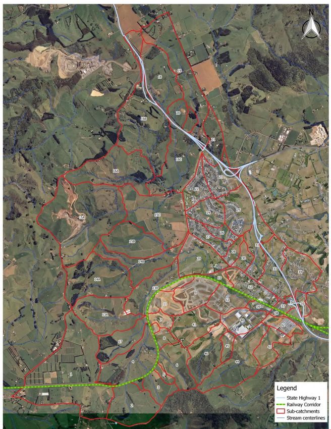
The Pōkeno catchment has been broken down into 46 subcatchments as shown in Figure 3-1.
3.3 Catchment Boundary Assumption
Section 3.3 from ‘Franklin District Council – Pōkeno Stormwater Catchment Management Plan –
September 2010 (FDC Ref D450/06)’ is no longer relevant due to the updated modelling work.
3.4 Previous Catchment Studies
No amendments to this section please refer to ‘Franklin District Council – Pōkeno Stormwater
Catchment Management Plan – September 2010 (FDC Ref D450/06)’ Section 3.4 for guidance.
3.5 Landscape
3.5.1 Topography
This section supersedes Section 3.5.1 of the 2010 CMP.
The catchment is characterised by a steep rural upper catchment to the north and west, divided
by several minor tributaries. The Pōkeno township is located within the flatter base of the
catchment area, mainly along the ridge between two waterways. The primary waterways are the
Tanitewhiora Stream (the catchment west of Helenslee Road and Great South Road) and the
Helenslee Stream (the catchment east of Helenslee Road and Great South Road) which move in a
southerly direction towards the Waikato River. A waterfall at Pōkeno East forms a natural hydraulic
boundary to the catchment. The Waikato Expressway and the North Island Main Trunk Railway
(NOMTR) are major transport routes that have altered the existing topography of the catchment
through cut and fill, disrupting floodplain function and overland flow. The key features are shown
in Figure 3-2 and Figure 3-3.
Ground levels within the catchment range from a reduced level (RL) of 227m at the highest point
of the catchment to RL 3m at the chosen termination point of the study area.
©WSP New Zealand Limited 2021 13Project Number: 3-39332.00
Waikato District Council
2021 Addendum to the 2010 Pōkeno Catchment Management Plan
Figure 3-1: Subcatchment Delineation (Waikato District Council, 2020)
©WSP New Zealand Limited 2021 14Project Number: 3-39332.00
Waikato District Council
2021 Addendum to the 2010 Pōkeno Catchment Management Plan
Figure 3-2: Existing Topography and Key Features (Waikato District Council, 2020)
©WSP New Zealand Limited 2021 15Project Number: 3-39332.00
Waikato District Council
2021 Addendum to the 2010 Pōkeno Catchment Management Plan
Figure 3-3: Land use and current locations of fill (Waikato District Council, 2020)
3.5.2 Vegetation
No amendments to this section please refer to ‘Franklin District Council – Pōkeno Stormwater
Catchment Management Plan – September 2010 (FDC Ref D450/06)’ Section 3.5.2 for guidance.
3.5.3 Streams
No amendments to this section please refer to ‘Franklin District Council – Pōkeno Stormwater
Catchment Management Plan – September 2010 (FDC Ref D450/06)’ Section 3.5.3 for guidance.
©WSP New Zealand Limited 2021 16Project Number: 3-39332.00
Waikato District Council
2021 Addendum to the 2010 Pōkeno Catchment Management Plan
3.5.4 Climate and Rainfall
This section supersedes Section 3.5.4 of the 2010 CMP.
The Waikato Stormwater Runoff Modelling Guideline (WSRMG) TR20-06 temporal pattern
(Waikato District Council, 2018) has been adopted for modelling purposes. Further detail on
rainfall and climate can be found in Section 5.2.1 and Section 5.2.3 respectively.
3.6 Soils and Geology
This section supersedes Section 3.6 of the 2010 CMP.
As shown in Figure 3-4, the Pōkeno catchment consists of three main soils classes:
1. South Auckland volcanic field – basalt lava, scoria, ash, lapilli and lithic tuff.
2. Taupo Pumice Alluvium – alluvium/colluvium.
3. Mercer Sandstone – sandstones and mudstones.
Figure 3-4: Pōkeno Geology and Soils (Waikato District Council, 2020)
©WSP New Zealand Limited 2021 17Project Number: 3-39332.00
Waikato District Council
2021 Addendum to the 2010 Pōkeno Catchment Management Plan
3.7 Existing Land Use and Potential Contaminated Lands
No amendments to this section please refer to ‘Franklin District Council – Pōkeno Stormwater
Catchment Management Plan – September 2010 (FDC Ref D450/06)’ Section 3.7 for guidance.
3.8 Existing Stormwater Infrastructure
This section supersedes Section 3.8 of the 2010 CMP.
The urban drainage network primarily serves the Pōkeno Township with an approximate 2-year
ARI level of service. The urban drainage network has not been individually modelled; however,
outlets are captured at the waterway boundaries.
Several local bridges and culverts cross the streams in the catchment. These act to restrict
stormwater discharge in some events (i.e. provide informal attenuation). Some of these overtop in
regular events (i.e. more frequently than 10% AEP). Most overtop during extreme storm events (e.g.
1% AEP event).
Pōkeno catchment does not form part of a rural drainage network but does feed into the
Mangatāwhiri Scheme, suggesting that discharges must consider impacts to these areas.
The railway traversing the southern section of the catchment acts as a barrier to overland flow with
several crossing points (bridges). This is a key transport corridor that is potentially at flood risk in
some scenarios. The SH1 embankment acts as a barrier to overland flow, however large culverts
provide significant capacity in all assessed events
3.9 Climate Change
This section supersedes Section 3.9 of the 2010 CMP.
Refer to Section 5.2.1 and 5.2.3 of this addendum for modelling climate change parameters.
4 Status of Receiving Environment
No amendments to this section please refer to ‘Franklin District Council – Pōkeno Stormwater
Catchment Management Plan – September 2010 (FDC Ref D450/06)’ Section 4 for guidance.
Refer to Section 5.14 for updated summary of stream erosion issues.
5 Stormwater Modelling
This section supersedes Section 5 of the 2010 CMP.
The 1D-2D model built for the 2018 Pōkeno flood risk study was adopted and used to update this
addendum.
For the purposes of this addendum, both the existing and future scenario flood mapping focuses
on the overland flow paths and the flood extents and reflects current approved development;
future development, rainfall and climate predictions (existing and a 2.1°C increase). The assessment
does not consider flood risk from urban overland flow (specifically within the Pōkeno township) or
the impacts of potential infill development (assumed to have mitigated flow).
The stormwater modelling was developed in two phases:
• Phase 1 – Updating and developing the existing Pōkeno Model to the existing situation.
©WSP New Zealand Limited 2021 18Project Number: 3-39332.00
Waikato District Council
2021 Addendum to the 2010 Pōkeno Catchment Management Plan
• Phase 2 – Imposing land use changes on the existing model and developing stormwater
management measures (primarily storage and culvert upgrades) to mitigate the effects of
development.
These phases are further detailed in the following sections
5.1 Hydrological Model
This section supersedes Section 5.1 of the 2010 CMP.
WDC engaged WSP Opus to update the HEC-HMS hydrology model into a revised hydrology
model. The catchment has been broken up into 46 sub-catchments and is presented in
Figure 3-1. Some larger sub-catchments have been revised and split into smaller sub
catchments as part of this study to help inform the location of potential future attenuation
areas. The key updates to the model are detailed in Section 5.2.
5.2 Selection of Hydrological Model Parameters
This section supersedes Section 5.2 of the 2010 CMP.
5.2.1 Rainfall
The TR20-06 temporal pattern has been adopted.
Rainfall was obtained using HIRDS Version 3 for the catchment area. In accordance with the
Hamilton Infrastructure Technical Specification (HITS) (Waikato Local Authority Shared Services,
2018) the recommended increase of 16.8% to the 1% AEP Rainfall has been adopted for climate
change. The rainfall depths are shown in Table 5-1.
Table 5-1: HIRDS (V3) Design Rainfall Depths (mm)
ARI
AEP 10m 20m 30m 60m 2h 6h 12h 24h 48h 72h
(years)
2 0.5 10.1 13.7 16.4 22.3 28.6 42.3 54.2 69.4 87.9 100.9
5 0.2 13.2 18 21.5 29.2 37.4 55.2 70.6 90.3 114.4 131.3
10 0.1 15.8 21.5 25.7 35 44.7 65.9 84.2 107.5 136.2 156.4
100 1 27.7 37.6 45.1 61.3 78.1 114.5 145.8 185.7 235.1 270
100+CC 1 32.4 43.9 52.7 71.6 91.2 133.7 170.3 216.9 274.6 315.4
5.2.2 Areal Reduction Factor
No areal reductions factors (ARFs) have been applied to the catchment design rainfall. This is due
to the following reasons:
• The HIRD’s data is produced as a point rainfall in a 10 km2 grid. The Pōkeno catchment is
only approximately 19 km2 in total and therefore it is not considered that application of ARFs
would cause a significant enough change in the rainfall intensity to be critical.
• The NZ guidance for ARFs is limited and therefore it would require additional work to
determine the appropriate ARF values, beyond the present scope of this study, and with
limited validity for the catchment size.
• Not using the ARF means that a more intense storm will be adopted. This will produce
marginally more conservative flow results.
©WSP New Zealand Limited 2021 19You can also read