Walmer Housing Project - SOCIO-ECONOMIC IMPACT ASSESSMENT October 2017 - SOCIO-ECONOMIC IMPACT ...
←
→
Page content transcription
If your browser does not render page correctly, please read the page content below
333333

                         Walmer Housing Project
                    SOCIO-ECONOMIC IMPACT ASSESSMENT

                                October 2017

  DEMACON Market Studies
                PO BOX 95530
               WATERKLOOF
                         0145
         Tel: +27 12 460 7009
         Fax: +27 12 346 5883
         Cell: +2782 898 8667
E-mail: hein@demacon.co.za
Website: www.demacon.co.za
                                    i
Walmer Housing Project: Socio-Economic Impact Assessment – October 2017

                             Demacon is a member of

  SOUTH AFRICAN PROPERTY OWNERS ASSOCIATION (SAPOA)

   SOUTH AFRICAN COUNCIL OF SHOPPING CENTRES (SACSC)

   The information contained in this report has been compiled with
   the utmost care and accuracy within the parameters specified in
  this document. Any decision based on the contents of this report
      is, however, the sole responsibility of the decision maker.

    This document represents an amended report relative to the 2015 study, specifically
           responding to comments regarding security and the amended layout.

                                     Enquiries:
                                     Hein du Toit
                               +27 12 460 7009 (t)
                               +27 12 346 5883 (f)
                               +27 82 8988 667 (c)
                              hein@demacon.co.za
                              www.demacon.co.za

                                             ii
Walmer Housing Project: Socio-Economic Impact Assessment – October 2017

                                                                TABLE OF CONTENTS

EXECUTIVE SUMMARY ...................................................................................................................................... 4
CHAPTER 1: INTRODUCTION ......................................................................................................................... 23
   1.1     BACKGROUND ................................................................................................................................................. 23
   1.2     PROJECT BRIEF & OBJECTIVES .......................................................................................................................... 23
   1.3     DEVELOPMENT SITE ......................................................................................................................................... 23
   1.4     NATURE OF THE PROJECT ................................................................................................................................ 24
   1.5     REPORT OUTLINE ............................................................................................................................................. 27
CHAPTER 2: LOCATION PROFILING ............................................................................................................. 28
   2.1     INTRODUCTION ............................................................................................................................................... 28
   2.2     UNDERSTADING THE REAL ESTATE MARKET .................................................................................................... 30
   2.3     INSTITUTIONAL OVERVIEW ............................................................................................................................. 31
   2.4     LOCATION THEORY AND BEHAVIOUR .............................................................................................................. 31
   2.5     SITE ASSESSMENT ............................................................................................................................................ 32
   2.6     SYNTHESIS ....................................................................................................................................................... 33
CHAPTER 3: SOCIO-ECONOMIC PROFILE................................................................................................... 36
   3.1     INTRODUCTION ............................................................................................................................................... 36
   3.2     STUDY AREA POPULATION ............................................................................................................................... 36
   3.3     AGE & GENDER PROFILE .................................................................................................................................. 37
   3.4     EDUCATION PROFILE ....................................................................................................................................... 40
   3.5     EMPLOYMENT PROFILE ................................................................................................................................... 40
   3.6     HOUSEHOLD INCOME PROFILE ........................................................................................................................ 41
   3.7     LIVING STANDARD MEASUREMENT ................................................................................................................ 44
   3.8     TENURE STATUS ............................................................................................................................................... 46
   3.9     DWELLING TYPE ............................................................................................................................................... 46
   3.10       SYNTHESIS ................................................................................................................................................... 47
CHAPTER 4: RESIDENTIAL MARKET ANALYSIS........................................................................................ 48
   4.1     INTRODUCTION ............................................................................................................................................... 48
   4.2     PORT ELIZABETH PROPERTY TRENDS ............................................................................................................... 48
   4.3     WALMER HEIGHTS PROPERTY TRENDS ............................................................................................................ 51
   4.4     SYNTHESIS ....................................................................................................................................................... 54
CHAPTER 5: CASE STUDY ANALYSIS .......................................................................................................... 55
   5.1     INTRODUCTION ............................................................................................................................................... 55
CHAPTER 6: IMPACT ASSESSMENT............................................................................................................. 63
   6.1     INTRODUCTION ............................................................................................................................................... 63
   6.2     PRICE DIFFERENTIAL ........................................................................................................................................ 63
   6.3     PROPERTY RATES & TAXES ............................................................................................................................... 65
   6.4     SECURITY ISSUES .............................................................................................................................................. 69
   6.5     RESIDENTIAL MARKET DEMAND ...................................................................................................................... 71
CHAPTER 7: FINDINGS & MITIGATION ......................................................................................................... 77
   7.1     OVERVIEW ....................................................................................................................................................... 77
   7.2     FINDINGS ......................................................................................................................................................... 77
   7.3     QUALITATIVE IMPACT ASSESSMENT ................................................................................................................ 79
   7.4     MITIGATION..................................................................................................................................................... 87
   7.5     CONCLUSION ................................................................................................................................................... 90

                                                                                     3
Walmer Housing Project: Socio-Economic Impact Assessment – October 2017

                                   EXECUTIVE SUMMARY

   ➢ PROJECT BRIEF

Demacon Market Studies were commissioned by SRK Consulting (South Africa) (Pty) Ltd. to
compile a proposal for a socio-economic impact assessment pertaining to the proposed Walmer
Housing Development. Based on an initial brief received, it is understood that the client requires
a proposal for a Socio-Economic Impact Assessment pertaining to the abovementioned
proposed project, including, inter alia, the following:

✓ Define the area potentially directly affected either socially or economically by the proposed
  project;
✓ Describe the baseline socio-economic conditions and character of this area, including property
  values;
✓ Comment on the appropriateness of the location of the development in light of the social and
  economic gradients of the area, as well as policy and other relevant considerations;
✓ Assess the potential impacts of the development proposal on socio-economic conditions in the
  surrounding areas including:
      o Projected effect on property value of adjacent neighbourhoods, and the associated
          impact on municipal rates in the area; and
      o Projected effect on security, crime and social ills in adjacent neighbourhoods;
✓ Address comments raised by IAPs from surrounding areas relating to the above
✓ Make recommendations and provide advice to the team regarding appropriate management of
  impacts identified and how best to incorporate these into the proposed development.

Map 1: Revised layout of the proposed residential township, Option A

                                                4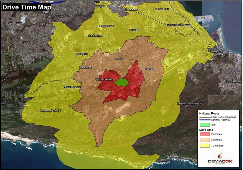
Walmer Housing Project: Socio-Economic Impact Assessment – October 2017

Map 2: Revised layout of the proposed residential township, Option B

   ➢ SITE ASSESSMENT

The following site characteristics are evident:

✓ The site is situated in Ward 1 of the municipal area.
✓ The site itself is situated adjacent Walmer Heights, the Walmer Country Club, Arlington Horse
  Race Course and Victoria Drive.
✓ The area is mainly characterised by low density formal houses. The expanding areas to the
  east is mostly characterised by new townhouse developments while the Port Elizabeth CBD
  area has a large segment of flats/townhouses. Gqebera is characterised by a mixture of formal
  (mostly subsidy) and informal structures.
✓ The majority of new residential development is taking place to the east at Lovemore Heights,
  Kamma Park and Lorraine Manor.
✓ The site lend itself to a residential development as it is adjacent an existing residential suburb
  to the north a golf course to the east and a race track on the west, while road access to major
  economic nodes via Victoria Drive (M18) to the south
✓ The Victoria Drive provides road access between the periphery of the urban area with economic
  nodes such as the airport, industrial areas adjacent the airport and commercial / retail activity.
✓ The proximity of the site to the Port Elizabeth airport, with associated noise impact does impact
  the value of the site. High-income suburbs are mostly located in quiet, pristine and aesthetic
  locations.
✓ The proximity of Gqebera to the site implies that the site is not optimally located for exclusive
  high-income residential development but rather a mixture of bonded and affordable bonded
  units. The layout of such a development will be crucial for successful development
✓ Walmer Heights is characterised as a mostly low-density suburb with houses and estates with
  limited apartments.

                                                  5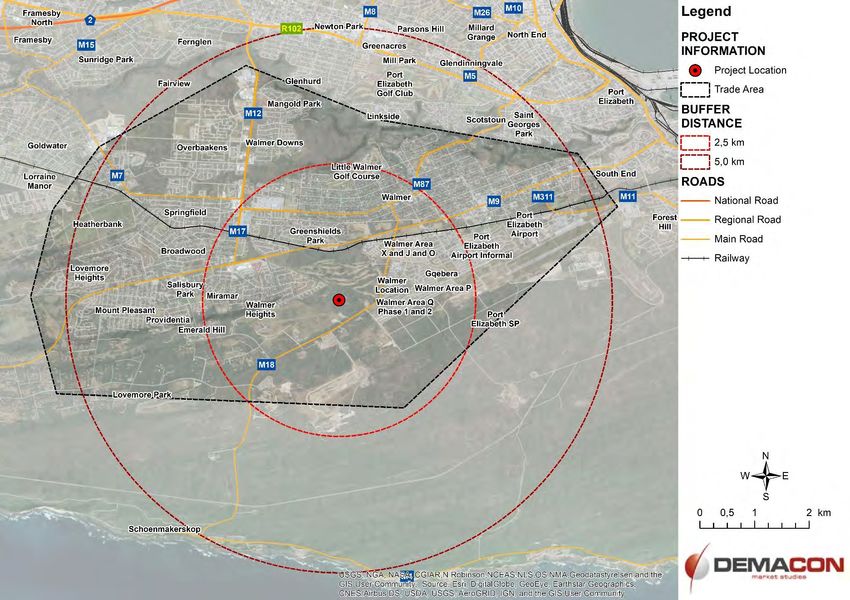
Walmer Housing Project: Socio-Economic Impact Assessment – October 2017

Figure 1: Property Type in Walmer Heights

                                        Property Type
                                               Apartments
                                                   5%

                                                                          Estate
                                                                           33%

                   Houses
                    62%

Source: Demacon ex. Deeds data, 2015

                                               6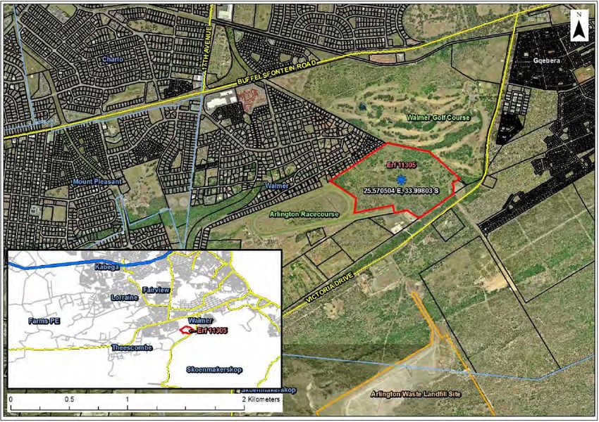
Walmer Housing Project: Socio-Economic Impact Assessment – October 2017

Map 2: Study Area

                                                                          7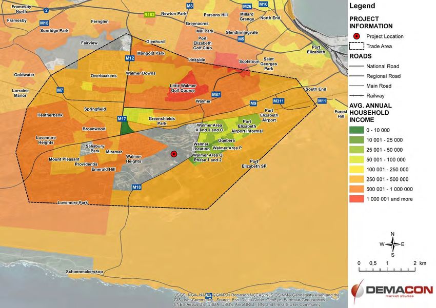
Walmer Housing Project: Socio-Economic Impact Assessment – October 2017

     ➢ SOCIO-ECONOMIC PROFILE

Table 1 summarises the socio-economic characteristics of the study area.

Table 1: Socio-economic indicators for study area

                          Variable                                                          Study Area

                                                                 ✓       59 874 people
 Study Area Population (2015)
                                                                 ✓       20 248 households
 Average household size (2015)                                   ✓       3 persons per household
                                                                  Age                               Female                    Male
                                                                  0-19                               29.5%                   30.8%
 Age & Gender profile (2011)                                      20-34                              25.7%                   26.6%
                                                                  35-64                              36.2%                   35.3%
                                                                  64+                                 8.6%                    7.3%
                                                                 ✓       2.6% - No schooling
 Level of education (2011)                                       ✓       32.5% - Grade 12
                                                                 ✓       25.1% - Higher education
                                                                 ✓       67.1% - Economically active of which 81.1% is
 Level of employment (2011)
                                                                         employed and 18.9% is unemployed
 Weighted Average Annual Household income
                                                                 ✓       R253 554 per annum
 (2015) - All LSM (only income earning
                                                                 ✓       R21 129 per month
 households)

 Weighted Average Annual Household income                        ✓       R382 829 per annum
 (2015) - LSM 4-10+                                              ✓       R31 902 per month
 Living Standard Measurement 1 – 3 group*                        ✓       35.5%
 Living Standard Measurement 4 – 10+ group                       ✓       64.5%
                                                                 ✓       63.4% - House or brick structure
 Dwelling Type
                                                                 ✓       16.2% - Informal
                                                                 ✓       36% - Occupy rent free
                                                                 ✓       33.9% - Owned and not paid off
 Tenure Status
                                                                 ✓       17.8% - Owned and paid
                                                                 ✓       12.4% - Rent
Source: Demacon ex Stats SA, 2015
* The LSM index is an internationally recognised instrument designed to profile a market in terms of a continuum of progressively
more developed and sophisticated market segments. The LSM system is based on a set of marketing differentiators, which group
consumers according to their standard of living, using criteria such as degree of urbanisation and ownership of assets (predominantly
luxury goods). Essentially, the LSM system is a wealth measure based on standard of living, rather than income alone. The market
segmentation continuum is divided into ten LSM segments, where LSM 1 signifies the lowest living standard and LSM 10+ signifies
the highest living standard. The LSM categories are defined and weighted in terms of the following 29 variables (refer to Table 3.2). It
is important to note that the LSM system is widely applied internationally for marketing and branding purposes, and that it is therefore
not an instrument developed locally to label or stereotype certain market segments.

The study areas is mostly a high income, highly educated, high employment area with low density
dwellings, the exception is the Gqebera area that have low income, informal dwellings and high
density.

     ➢ RESIDENTIAL MARKET ACTIVITY

The sales price in Port Elizabeth has experienced two periods of growth in the freehold market.
The first period was between 2005 and 2010 where growth averaged 20.5% per annum and the

                                                                     8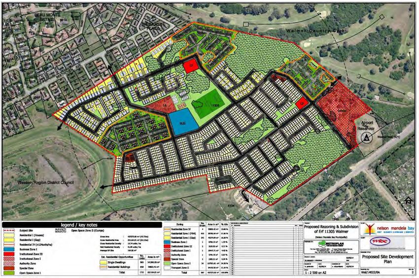
Walmer Housing Project: Socio-Economic Impact Assessment – October 2017

second period was between 2011 and 2015 with a growth rate of 13.7%. A significant decrease in
average sales price was evident in 2011 which also impacted the average sales price in Walmer
Heights. Figure 2 illustrates the average sales price growth for houses in Walmer Heights and
compares it to the average sales price of houses in Port Elizabeth.

Figure 2: Walmer Heights Average Sales Price: Houses

                                         Average Sales Price: Houses
  R 1 800 000
  R 1 600 000
  R 1 400 000
  R 1 200 000
  R 1 000 000
   R 800 000
   R 600 000
   R 400 000
   R 200 000
         R-
                 2004    2005     2006     2007     2008       2009    2010    2011       2012      2013       2014    2015

                                              Walmer Heights           Port Elizabeth

Source: Demacon ex. Deeds data, 2015

Sales prices of Walmer Heights correlates with that of Port Elizabeth. It is evident that sales prices
have increased and doubled when compared to 2004 and that the average sales price for a house
in Walmer is higher than the average for Port Elizabeth. Figure 3 shows that Walmer Heights is
one of the higher priced suburbs in the municipal area.

Figure 3: Average Sales Price of Walmer Compared, 2014

                                          Average Sales Price, 2014
  R 3 000 000

  R 2 500 000    R 2 386 875
                                R 2 042 470    R 1 980 759
  R 2 000 000                                                  R 1 795 879
                                                                              R 1 556 850        R 1 468 324
  R 1 500 000
                                                                                                                 R 1 132 500
  R 1 000 000

   R 500 000

         R-
                  Mill Park    Summerstrand     Lovemore           Walmer       Walmer           Humewood       Newton Park
                                                 Heights                        Heights
Source: Demacon ex. Deeds data, 2015

The growth trend is illustrated in Table 2. The long term growth for freehold properties between
2005 and 2015 was 8.5% while the sectional scheme is lower at 5.3%.

                                                               9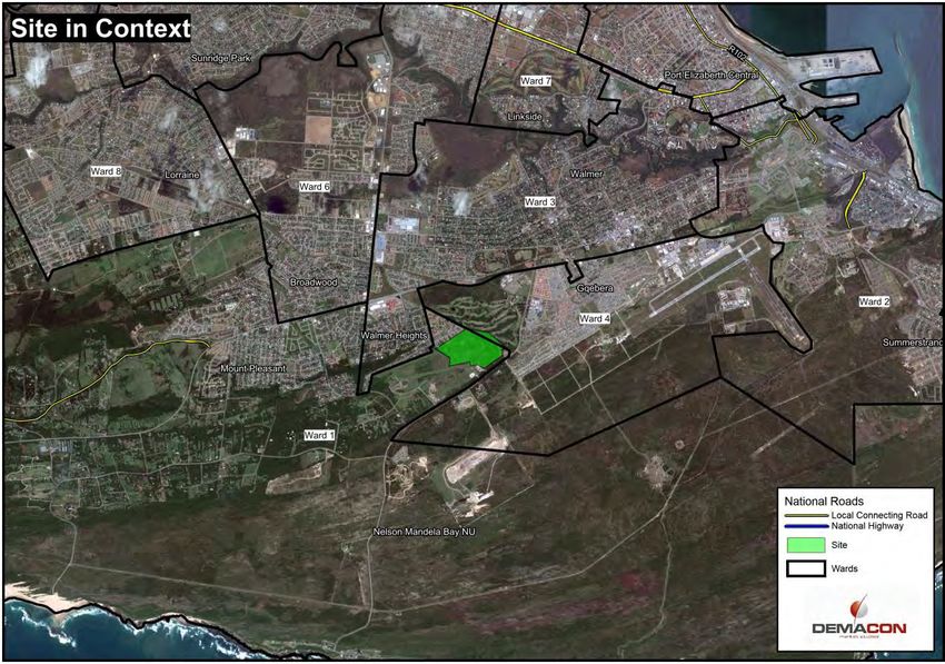
Walmer Housing Project: Socio-Economic Impact Assessment – October 2017

Table 2: Sales price growth
                                                                  Long Term (2005-2015)
 Freehold                                                                                      8.5%
 Sectional Scheme                                                                              5.3%
Source: Demacon ex. Deeds data, 2015

    ➢ IMPACT ASSESSMENT

A case study analysis is provided to determine if the development of a lower value property product
will have an impact on existing property price trends for a middle to high income suburb. This
analysis makes use of a number of case studies throughout South Africa on developments over
the past decade, in particular where lower income properties were developed adjacent or near
middle to higher income properties. The assessment considers historical price trends and the result
(pre- and post- implementation) of the low income project. Based on this research, a price
differential range was calculated.

Price Differential
The price differential analysis is used to firstly determine the optimum, open market price
distribution price of properties within a suburb. Secondly, it is used as a guideline to identify the
impact of the affordable housing development on property prices in Walmer Heights. The price
differential analysis for middle and high-income suburbs, such as Walmer Heights, should not
be more than 60% below the average house price value of the suburb. In other words should a
new lower income development be implemented the price of the most affordable unit in the new
development should not be more than 60% of the average house price of the established
surrounding environment.

The price differential for Walmer Heights is illustrated in in Table 3.

Table 3: Walmer Heights Price Differential, 2013 - 2015
                                                            Price Differential   Price Ratio (higher
              Lowest          Average     Highest
                                                          (below the average)      than average)
 2013           769 000       1 317 300     2 100 000                      42%                59.4%
 2014           800 000       1 556 850     2 775 000                      49%                78.2%
 2015           950 000       1 532 273     2 400 000                      38%                56.6%
Source: Demacon ex. Deeds data, 2015

Given the aforementioned, the optimum market based price differential that would not constrain
house price growth (and concomitant property rates and taxes income for the metro) would be
R620 000. Graph 1 illustrates the price differential for Walmer Heights where the average house
price is approximately R1.5 million.

Graph 1: Price Differential, (Based on 2014/2015 property sales prices)

                                                    10
Walmer Housing Project: Socio-Economic Impact Assessment – October 2017
In terms of the analysis there appears to be an opportunity to introduce properties within a slightly
broader price band. The current price differential is 40%-50% and could be increased to 50%-60%.
This implies that new properties, priced as low as R620 000 will not curb house price growth and
therefore municipal income. However, properties below this value will in all probability be harmful
to the surrounding environment in terms of healthy price growth and sustained municipal revenue.
Property Rates & Taxes
The draft scoping report indicates the development site is earmarked for affordable residential
development which include subsidy houses, social houses (rentals) and gap or affordable houses
(FLISP). A total of 1 100 units with a combination of the abovementioned units is proposed for the
site. Two scenarios is provided to illustrate the impact of the development next to Walmer Heights.
Table 4 illustrates Scenario 1 while Table 5 shows Scenario 2 and a summary with the cumulative
impact in Table 6.
Scenario 1 illustrates the current market trends in Walmer Heights. The suburb has a total of 905
properties with an average sales price of R 1.5 million in 2015. The average sales price growth is
8.5% per annum while property tax is calculated based on NMBM rates.
Walmer Heights has to date been buffered from price deceleration on account of the green belt
(Arlington Horse Race Course and the Walmer Country club – this property is however available
for sale and redevelopment) between Walmer Heights an Gqebera.
Scenario 2 includes the affordable housing development in the property tax calculation. The
scenario assumes the development will take place in 2018/19 with 600 subsidy, 241 affordable
and 259 social (rental) units to increase the number of properties to 1 746 including the 905 bonded
properties. The sales price growth of the bonded properties will decelerate to 2% per annum
while the subsidy and affordable units will have annual growth of 5.1%, albeit from a lower base
than the bonded properties. The average bonded property sales price will increase from R1.5
million in 2015 to R1.8 million in 2025 which is significantly lower than the property value in
Scenario 1.
Table 4: Scenario 1 – Property tax implication based on continued stable house price growth
Scenario 1: Status Quo (no social housing) 2015 2017 2019 2021 2023 2025
Number of Properties (Bonded) 905 905 905 905 905 905
Property taxes (R’000) 13 370 15 763 18 580 21 896 25 800 30 396
Table 5: Scenario 2 – Property tax calculation based on decelerating property price growth
Scenario 2 2015 2017 2019 2021 2023 2025
Bonded 905 905 905 905 905 905
Affordable - 170 170 170 170
Social Housing
- 490 490 490 490
(rentals)
Subsidy - 536 536 536 536
Total Number of
905 905 2 101 2 101 2 101 2 101
Properties
Average Bonded
1 532 273 1 594 177 1 658 582 1 725 588 1 795 302 1 867 832
Price
Average Affordable
390 000 430 794 475 856 525 631 580 612 641 345
Price
Subsidy house
157 665 174 190 192 447 212 618 234 902
price
Suburb Average
1 532 273 1 594 177 1 010 806 1 054 961 1 101 248 1 149 787
Price
Property Rates &
- 433 413 433 413 433 413 433 413
Taxes (social rental)
11Walmer Housing Project: Socio-Economic Impact Assessment – October 2017
Scenario 2 2015 2017 2019 2021 2023 2025
Property rates &
Taxes - - 1 648 348 1 721 438 1 798 055 1 878 402
(affordable/FLISP)
Property rates &
13 370 187 13 915 683 8 775 030 9 164 125 9 571 997 9 999 727
Taxes (bonded)
Total Property
13 370 187 13 915 683 10 856 791 11 318 975 11 803 465 12 311 541
Tax (R’000)
Table 6: Net difference between Scenario 1 & 2 property tax modelling on account of the Walmer
Housing Project as in Map 1 (R’000)
2017 2018 2021 2023 2025
Scenario 1: Bonded Housing (no subsidy) 15 763 17 114 21 896 25 800 30 396
Scenario 2: Bonded Housing & Subsidy Development 15 071 15 401 16 441 17 179 17 954
Yearly Difference (loss in tax) - 691 - 1 712 - 5 454 - 8 621 - 12 442
Cumulative Difference (loss in tax) - 460 - 2 172 - 14 552 - 30 136 - 53 021
Findings (Scenario 1 & 2)
• In Scenario 1
▪ Property price growth of between 5% and 8% for properties further than 1000m
from the low income housing area (Walmer & Walmer Heights)
▪ The property tax increased from R13.3 million in 2015 to R30.3 million in 2025
• In Scenario 2
▪ The suburb average price decrease from R1.5 million in 2015 to R1.01 million
in 2019 due to the introduction of subsidy, affordable and social houses
▪ The yearly price growth of the bonded segment decelerate from 8% to 2% per
annum due to the introduction of low-income housing stock. This will result in
negative real growth in house prices
▪ The bonded property prices shows slower growth, which result in a decrease in
property tax collected from the suburb
▪ The property tax decreased from R13.3 million in 2015 to R12.3 million in 2025
• Summary
▪ The introduction of subsidy, affordable and rental housing will result in a
decrease in the amount of tax received from the suburbs to the local authority
▪ Cumulative the NMBM will lose R53 million in property tax over a 10 year
period with the development of subsidy, affordable and social houses adjacent
a high-income bonded suburb.
▪ Decelerated growth and dampening effect on middle-higher property prices will
be evident in Walmer Heights.
This is a significant loss in income for the Nelson Mandela Bay Municipality due to sub-optimal
positioning of an affordable, low-income subsidy component. A layout aligned with sound economic
principles, including systematic pricing contours can be expected to yield positive impacts leaning
more towards scenario 1 (Table 6.2). On the contrary, a low cost / low income and affordable
development that does not reflect the necessary sensitivities to surrounding real estate price
realities could yield negative impact scenarios. Of the recently (September 2017) revised layouts,
Option B can be expected to be the most viable option based on sound economic principles –
subject to minor revision.
12Walmer Housing Project: Socio-Economic Impact Assessment – October 2017
➢ RECOMMENDATIONS
Mitigation can be achieved through project composition, pricing, layout and access considerations.
These recommendations are based on the initial layout of 2015.
Map 3: Initial layout of the proposed residential township
Composition
Higher priced properties tend to locate in close proximity to one another – this is consistent with
Tiebout theory of the invisible foot (like attracts like). Within this mechanism lies the powerful
multiplier mechanism of agglomeration and critical mass (positive growth triggers further growth).
The Walmer Heights suburb is regarded as one of the highest income areas in the Nelson Mandela
Bay area with sought after low density, high income properties. New residential development
adjacent to Walmer Heights should ideally be in keeping with prevalent market prices in order to
continue to foster price growth of around 8.5% per annum.
Pricing
The current price differential in Walmer Heights is 40%-50% and could be increased to be a
maximum of 50%-60%. This implies that new properties should be priced from a minimum not
below R620 000 which, consistent with the above, will not decelerate price growth and municipal
income in Walmer Heights. However, properties below this minimum entry level value will, in all
probability, decelerate prevalent price growth and concomitant municipal property tax income.
The market demand modelling did, however, indicate that there is a potential demand for
residential units from as low as ±R400 000 for the area. The appropriate placement of such units
will be crucial in order not to exert negative forces on price growth. Through a deliberate, planned
arrangement the lower value offering should be situated adjacent Victoria drive opposite Gqebera
to mitigate negative price growth and associated impacts.
13Walmer Housing Project: Socio-Economic Impact Assessment – October 2017
Layout
The preferred residential typology mix should maximise investment for the buyer, maximise income
for the local authority and address the housing needs of the area whilst protecting and nurturing
existing upmarket residential investment to which the municipality has an equal responsibility.
Based on the above analyses and findings and with the housing needs of the area considered, the
following conceptual site arrangement would reflect the necessary sensitivity to property price
dynamics and, as a result, yield a “best fit” scenario with minimum negative impacts - real and
perceived.
Map 4: Conceptual Site Arrangement to Mitigate Price Growth & Property Tax Impacts
The site arrangement makes provision for low-density, mid- to higher priced properties adjacent
the existing Walmer Heights suburb and the Walmer Country Club to mitigate price impacts on the
residential assets. The lower priced social and affordable component should ideally be located
along Victoria Drive to improve proximity and accessibility to public transport.
The site arrangement ensures that higher density units are in close proximity to major
transportation routes and to facilitate access to public transport. The intermediate zone will offer a
balanced transition between lower and higher density units. This site configuration reflects the
necessary sensitivity towards existing asset owners on the one hand and the optimum blend of
more affordable units in the market. As such the revised layout, in particular Option B, reflects a
more sustainable solution.
Access
In the context of the aforementioned a duel access configuration is recommended. Lower density,
higher priced units could attain access via a Walmer Heights link to and from Beethoven Avenue.
On the other hand access to and from the higher density, lower priced units to Victoria Road (M18)
is a vital consideration.
14Walmer Housing Project: Socio-Economic Impact Assessment – October 2017
Security
According to research1 subsidized housing doesn’t bring crime or disinvestment if it’s well designed
and managed and if the neighbourhood is safe and stable to begin with. Many communities fight
to exclude affordable housing developments because they fear rising crime and declining property
values. Some research has found that an influx of subsidized households may affect crime rates,
but only in communities that are already struggling with disinvestment and worsening crime. A
much larger body of evidence confirms Massey’s new findings that crime and property values are
unaffected by the construction of subsidized housing.
Mitigations to limit the possible increase in crime rates in the area, include the site arrangement
proposed above – locating higher priced units next to Walmer Heights would limit increased crime
rates in the area. Another mitigation measure would include the use of defensible space.
Defensible space is achieved both through “target hardening,” design features that repel criminal
activity such as fences, gates, and locks, and through design elements that encourage residents
to assert control over their public spaces and neighbourhood environments (Newman 1972, p.4).
The quantitative research affirms the invisible, though distinctly eroding impacts of the
inappropriate positioning and sub-optimal price variance thresholds of low income residential
development when introduced to established, middle and high income suburban markets. The
price growth and unseen medium to longer term property tax implications contrast the political
objectives aspired to through these mixed income housing schemes. The findings clearly illustrate
that there is a critical point beyond which a too large price differential erodes future property price
growth and, by default, municipal property tax income. In the interest of sustained national fiscus
growth, in a country with a narrow tax support base, this is fast becoming a rapidly increasing vital
consideration.
Revised 2017 layout – Option A and Option B
After these recommendations, amended layouts (Option A and Option B) were provided. The
revised layout options of the township can be seen in Map 4 and Map 5. The impact was assessed
for the revised layouts Option A and Option B.
The main issues have been addressed to a large extent. Option B closely aligns with the comments
provided in the socio-economic impact report. The development still encompasses a large subsidy
component, but an attempt has been made to create price contours that will be sensitive to possible
price impacts due to the low income housing. From an economic perspective, the option most likely
to have the least negative impact is Option B.
1
https://www.urban.org/urban-wire/affordable-housing-safe-neighborhoods-four-lessons-success
15Walmer Housing Project: Socio-Economic Impact Assessment – October 2017
Map 5: Layout of the proposed residential township, Option A
Map 6: Layout of the proposed residential township, Option B
16Walmer Housing Project: Socio-Economic Impact Assessment – October 2017
Table 7: Impact Table – Walmer Housing Project Revised Layout Option A
IMPACT
SIGNIFICANCE
IMPACT SIGNIFICANCE PRIOR TO
STATUS OF IMPACT
POST
MITIGATION
MITIGATION
SPECIFIC
SIGNIFICANCE
SIGNIFICANCE
PROBABILITY
THEME DESCRIPTION & MITIGATION MEASURES
MAGNITUDE
IMPACT
DURATION
MAGNITUDE
EXTENT
CONSTRUCTION PHASE
Housing Job creation + 3 2 3 5 Medium The construction of the proposed development may create 3 Medium
Development new employment opportunities for the local economy.
Ensure that local employees are used during the
construction phase.
Local + 3 2 3 5 Medium New construction activity will create capital investment that 3 Medium
Economic will in turn benefit the local economy. The project will
furthermore make a positive contribution in respect of the
Growth creation of productive, rateable real estate assets.
Infrastructure + 2 2 2 5 Medium The proposed development will facilitate investment in 2 Medium
Investment & infrastructure development and expansion. Albeit that the
initial infrastructure investment constitutes a short-term
Development impact, prolonged benefits are created in the local
economy.
OPERATIONAL PHASE
Housing Job creation + 2 5 2 5 Medium Increased production as a result of the Walmer Housing 3 Medium
Development Project will create and sustain new job opportunities in
various sectors of the economy.
Local + 2 5 2 5 Medium The proposed development will facilitate investment in key 2 Medium
Economic local sectors, which will translate into additional business
sales and additional GGP.
Growth
Rates & Tax - 2 5 4 5 High The development will facilitate limited real estate 3 Medium
Base investment, job creation and economic growth, which, in
turn will contribute to the limited creation of productive,
Expansion rateable assets.
17Walmer Housing Project: Socio-Economic Impact Assessment – October 2017
IMPACT
SIGNIFICANCE
IMPACT SIGNIFICANCE PRIOR TO
STATUS OF IMPACT
POST
MITIGATION
MITIGATION
SPECIFIC
SIGNIFICANCE
SIGNIFICANCE
PROBABILITY
THEME DESCRIPTION & MITIGATION MEASURES
MAGNITUDE
IMPACT
DURATION
MAGNITUDE
EXTENT
The status of the impact could be reversed from a
negative to a positive
Property - 2 5 4 4 Medium to The development of low income housing next to the upper 2 Medium
Prices High class area of Walmer Heights will negatively impact
property prices in the area.
The inclusion of definite pricing contours will ensure a less
negative impact. The area directly adjacent Walmer
Heights should be reserved for higher income households.
Addressing + 2 3 3 4 Medium The development will provide housing opportunities for 3 Medium
Housing Need households currently occupying informal dwellings,
thereby alleviating the housing backlog of NMBM.
Security - 2 3 3 4 Medium to The incidences of crime may decrease over time, as the 2 Medium
High community becomes increasing socially upward mobile.
The inclusion of target hardening aspects will minimize
crime. Development of vacant land in itself could be
utilised as a mitigation measure in itself and will result in a
positive impact.
Reduced risk + 2 5 3 5 Medium to Vacant land in metropolitan regions will continue to be 2 Medium
of illegal land High subjected to risks associated with land invasion. Although
it is not a deciding consideration for the development, the
invasion benefit of having productive development that contribute
towards rates and taxes could potentially outweigh the
benefit associated with illegal land occupation.
If developed as a secure access controlled estate which is
increasingly becoming common practice, even in lower
income communities, the risk will be minimum
Source: Demacon, 2017
18Walmer Housing Project: Socio-Economic Impact Assessment – October 2017
Table 8: Impact Table – Walmer Housing Project Revised Layout Option B
IMPACT
SIGNIFICANCE
IMPACT SIGNIFICANCE PRIOR TO
STATUS OF IMPACT
POST
MITIGATION
MITIGATION
SPECIFIC
SIGNIFICANCE
SIGNIFICANCE
PROBABILITY
THEME DESCRIPTION & MITIGATION MEASURES
MAGNITUDE
IMPACT
DURATION
MAGNITUDE
EXTENT
CONSTRUCTION PHASE
Housing Job creation + 3 2 3 5 Medium The construction of the proposed development may create 3 Medium
Development new employment opportunities for the local economy.
Ensure that local employees are used during the
construction phase.
Local + 3 2 3 5 Medium New construction activity will create capital investment that 3 Medium
Economic will in turn benefit the local economy. The project will
furthermore make a positive contribution in respect of the
Growth creation of productive, rateable real estate assets.
Infrastructure + 2 2 2 5 Medium The proposed development will facilitate investment in 2 Medium
Investment & infrastructure development and expansion. Albeit that the
initial infrastructure investment constitutes a short-term
Development impact, prolonged benefits are created in the local
economy.
OPERATIONAL PHASE
Housing Job creation + 2 5 2 5 Medium Increased production as a result of the Walmer Housing 3 Medium
Development Project will create and sustain new job opportunities in
various sectors of the economy.
Local + 2 5 2 5 Medium The proposed development will facilitate investment in key 2 Medium
Economic local sectors, which will translate into additional business
sales and additional GGP.
Growth
Rates & Tax - 2 5 3 5 Medium to The development could facilitate real estate investment, 2 Low to
Base High job creation and economic growth, which, in turn will Medium
contribute to the creation of productive, rateable assets.
Expansion
19Walmer Housing Project: Socio-Economic Impact Assessment – October 2017
IMPACT
SIGNIFICANCE
IMPACT SIGNIFICANCE PRIOR TO
STATUS OF IMPACT
POST
MITIGATION
MITIGATION
SPECIFIC
SIGNIFICANCE
SIGNIFICANCE
PROBABILITY
THEME DESCRIPTION & MITIGATION MEASURES
MAGNITUDE
IMPACT
DURATION
MAGNITUDE
EXTENT
The status of the impact could be reversed from a
negative to a positive if the house pricing contours are
included and the northern section should be priced
R620 000 and upwards and the layout should not be
permeable
Property - 2 5 2 4 Medium The development of low income housing next to the upper 0 Low to
Prices class area of Walmer Heights will negatively impact Medium
property prices in the area.
The inclusion of definite pricing contours will ensure a less
negative impact. The area directly adjacent Walmer
Heights should be reserved for higher income households.
Positive but neutral
Addressing + 2 3 3 4 Medium The development will provide housing opportunities for 3 Medium
Housing Need households currently occupying informal dwellings,
thereby alleviating the housing backlog of NMBM.
Security - 2 3 2 4 Medium to The incidences of crime may decrease over time, as the 1 Low
High community becomes increasing socially upward mobile.
The inclusion of target hardening aspects will minimize
crime. Development of vacant land in itself could be
utilised as a mitigation measure in itself and will result in a
positive impact.
Reduced risk + 2 5 3 5 Medium to Vacant land in metropolitan regions will continue to be 1 Medium
of illegal land High subjected to risks associated with land invasion. Although
it is not a deciding consideration for the development, the
invasion benefit of having productive development that contribute
towards rates and taxes could potentially outweigh the
benefit associated with illegal land occupation.
20Walmer Housing Project: Socio-Economic Impact Assessment – October 2017
IMPACT
SIGNIFICANCE
IMPACT SIGNIFICANCE PRIOR TO
STATUS OF IMPACT
POST
MITIGATION
MITIGATION
SPECIFIC
SIGNIFICANCE
SIGNIFICANCE
PROBABILITY
THEME DESCRIPTION & MITIGATION MEASURES
MAGNITUDE
IMPACT
DURATION
MAGNITUDE
EXTENT
If developed as a secure access controlled estate which is
increasingly becoming common practice, even in lower
income communities, the risk will be minimum
Source: Demacon, 2017
21Walmer Housing Project: Socio-Economic Impact Assessment – October 2017
The business site is still positioned to allow through-traffic. The business site should ideally not be
internalised, as an internalised business site does, generally, not function optimally and the
development does not have sufficient critical mass to independently sustain a business site. The
business site should ideally be located directly adjacent the M18.
Although subsidy housing is not rateable for at least 8 years, the rating of social housing is entirely
up to the discretion of the local authority. Most local authorities opt not to rate social housing purely
based on the principle of subsidisation. The financial sustainability of the development will
ultimately hinge on the effectiveness with which the local authority collects taxes from the area.
➢ CONCLUSION
Beaumonte Estate and Walmer Heights is currently buffered from direct property price impacts of
the nearby Quebera by a green zone of approximately 800m wide. The vacant land in itself,
however, poses a significant threat in terms of land invasion. Development of a mixed typology
housing development may, to an extent, mitigate this risk. The aspiration should, however, be to
create sensible pricing contours in order to mitigate the decelerating price growth effect of low
income housing on high income housing. Erroneously, the location of low income households in
close proximity to high income households does not in itself effect socio-economic upliftment or
improve access to job opportunities. The ideal minimum price for properties adjoining the high
income Walmer Heights is recommend from R620 000. In order to mitigate security and associated
socio-economic concerns, the revised layout should respond to pricing contours and permeability
of the development should be limited. It is also recommended that the business site should not be
internalised: retail sales performance can be significantly enhance simply by positioning the
business site adjacent or close to the M18.
22Walmer Housing Project: Socio-Economic Impact Assessment – October 2017
1 CHAPTER 1: INTRODUCTION
1.1 BACKGROUND
Chapter one provides an introduction and concise roadmap of the Walmer Housing Development
Socio-Economic Impact Assessment. The chapter also provides concise background to the
project, the study methodology as well as a report outline.
1.2 PROJECT BRIEF & OBJECTIVES
Demacon Market Studies were commissioned by SRK Consulting (South Africa) (Pty) Ltd. to
compile a proposal for a socio-economic impact assessment pertaining to the proposed Walmer
Housing Development.
Based on an initial brief received, it is understood that the client requires a proposal for a Socio-
Economic Impact Assessment pertaining to the abovementioned proposed project, including,
inter alia, the following:
✓ Define the area potentially directly affected either socially or economically by the proposed
project;
✓ Describe the baseline socio-economic conditions and character of this area, including property
values;
✓ Comment on the appropriateness of the location of the development in light of the social and
economic gradients of the area, as well as policy and other relevant considerations;
✓ Assess the potential impacts of the development proposal on socio-economic conditions in the
surrounding areas including:
o Projected effect on property value of adjacent neighbourhoods, and the associated
impact on municipal rates in the area; and
o Projected effect on security, crime and social ills in adjacent neighbourhoods;
✓ Address comments raised by IAPs from surrounding areas relating to the above
✓ Make recommendations and provide advice to the team regarding appropriate management of
impacts identified and how best to incorporate these into the proposed development.
1.3 DEVELOPMENT SITE
The development site is situated in Walmer in Port Elizabeth. Map 1.1 shows the location of the
site.
23Walmer Housing Project: Socio-Economic Impact Assessment – October 2017
Map 1.1: Site Map
1.4 NATURE OF THE PROJECT
The Nelson Mandela Bay Metro proposes to construct a mixed typology housing development
together with associated facilities and infrastructure on erf 11305, Walmer, to cater for the overflow
of residents currently living in informal settlements in the Walmer Gqebera area. Approximately
1 196 (Option B) to 1 603 (Option A) residential units are proposed (see preliminary layout in Map
1.2), along with associated community facilities and services infrastructure. The development will
connect onto existing bulk services infrastructure in the area. The proposed site is 43.74 ha in size
and located on municipally owned land which has been previously disturbed (through activities
such as farming).
The layout provides for the development of formal residential units to accommodate beneficiaries
to be relocated from informal settlements in Walmer Gqebera. The beneficiaries will receive a
formal structure (Free basic house/RDP, of which approximately 600 units are allowed for) to be
built in accordance with NHBRC Standards and National Building Regulation. The remainder of
the units (approximately 1,100) will be offered to beneficiaries who qualify for Socially Housing,
GAP Housing and Open Market once the needs of the target groups are met. A portion of the
layout abutting the suburb of Walmer Heights has been set aside for either social housing or GAP
housing (possibly Finance Linked Individual Subsidy Programme (FLISP) units) to allow for a
transition area between the Free Basic House and Walmer Heights. Images of what the
development is anticipated to look like are provided in Figure 1.1, and descriptions of the proposed
housing typologies are provided below.
Free Basic House/RDP
• Fully State Subsidised Housing – for beneficiaries earning up to R3,500 per month;(Still the
same income bend)
24Walmer Housing Project: Socio-Economic Impact Assessment – October 2017
• Each unit at least 40 m², and costing approximately R160,000 each to build (made up of
R43000,00 for serviced sites and plus/minus R120 000.00 for the top structure);
• Beneficiaries will depend entirely on being housed by the state without any expectation of
making financial contributions towards the house/services/ transfer/ registration costs for the
property to be received; and
• Units will be either free standing or semi-detached single storey buildings.
GAP / FLISP Housing
• Partially Subsidised housing, where the state subsidy is supplemented by private funding;
• Each unit >40 m²;
• For financially employed individuals who can afford mortgage loans of up to R300,000; and
• Units will be detached, semi-detached single storey or double storey buildings.
Social Housing
• Units offered for rent to beneficiaries earning between R1,500 and R15 000 per month. Policy
stipulates that the rentals paid should not exceed 30% of the gross income of the
tenant. This would determine the size of unit allocated to the beneficiary. The units will be
owned and managed by an accredited Social Housing Institution that will hold the stock for a
minimum of 15 years, and may either re-finance for another 15 years or sell it off to tenants
thereafter; subject to providing remaining tenants who still wish to rent with equivalent rental
(social) accommodation for another period of 15 years
• Each unit ±30-45 m²; 1-2 bedroom apartments
• Units will be in 3 or 4 storey apartment buildings, in an access controlled complex, similar to
those in the nearby Walmer Link development.
Open market housing
• Stand-alone units priced at above R400,000, for beneficiaries earning above R15,000 per
month. The so called GAP Market
Figure 1.1: Description of proposed housing typologies
25Walmer Housing Project: Socio-Economic Impact Assessment – October 2017
The layout of the township is evident in Map 1.2
Map 1.2: Layout of the proposed residential township, Option A
26Walmer Housing Project: Socio-Economic Impact Assessment – October 2017
Map 1.3: Layout of the proposed residential township, Option B
1.5 REPORT OUTLINE
The remainder of the report is structured in terms of the following main headings:
Chapter 2: Location Profiling
Chapter 3: Socio-Economic Profile
Chapter 4: Residential Market Analysis
Chapter 5: Case Study Analysis
Chapter 6: Impact Assessment
Chapter 7: Findings & Mitigation
27Walmer Housing Project: Socio-Economic Impact Assessment – October 2017
2 CHAPTER 2: LOCATION PROFILING
2.1 INTRODUCTION
The aim of this chapter provide an overview of the location characteristics of the site. The location
of the site within the Nelson Mandela Bay Municipality (NMBM) is shown in Map 2.1.
Map 2.1: Site in Context
The site is situated in Ward 1 of the municipal area. A portion of Walmer Heights (Beaumonte
Estates) is also located in this ward, while the largest part of Walmer Heights is located in Ward 3
that includes the Walmer suburb. Gqebera, to the south east of the site is located in Ward 4.
The site itself is situated adjacent Walmer Heights, the Walmer Country Club, Arlington Horse
Race Course, which is currently vacant, and Victoria Drive in Ward 5. The accessibility to and from
the site is illustrated in Map 2.2.
A 2km drive time from the site has access to the local suburbs of Walmer Heights and Gqebera
which is adjacent to the site. The 5km drive time have access to suburbs within the larger area and
where some commercial and retail activity is present. The larger industrial nodes, CBD and access
to major roads is 10 minutes’ drive from the site.
28Walmer Housing Project: Socio-Economic Impact Assessment – October 2017
Map 2.2: Drive Time
29Walmer Housing Project: Socio-Economic Impact Assessment – October 2017
2.2 UNDERSTADING THE REAL ESTATE MARKET2
In a number of North American cities it is obvious that poor households tend to stay in close
proximity to the CBD as they cannot afford high transport cost and needs to stay close to working
opportunities. These areas have high site rent due to the proximity to the CBD resulting in higher
densities as people occupy less horizontal space and consequently are stacked vertically to afford
the rent. This is characterised as the prisoner’s dilemma, where poor people live on some of the
most potentially expensive land and cannot afford to escape (relocate).
One of the main reasons for the development of erf 11305 adjacent Walmer Heights is to
accommodate the overflow of residents from Gqebera. The area has experienced significant
densification in an area adjacent an established high income residential node and is in close
proximity to economic activity. Gqebera represent a similar situation as those in North America
where the poor has settled in an area characterised by high land values and is in close proximity
to employment opportunities.
Furthermore, the setting created by surrounding land uses has an effect on any individual
parcel of land. An individual parcel of land is affected by the surrounding land uses which implies
that any piece of land does not exist in isolation and that its economic value are inextricably linked
to its surroundings. A change in the surrounding land uses results in a break in the existing
neighbourhood associations. In real estate there is a connection between adjacent properties and
the stability of one site is associated with the stability of others, much the same way as an
ecological chain that is sensitive to change.
The environment have a significant impact on the location of land uses throughout a city. First there
is the physical environment and often it is evident that residential areas are attracted to hilly section
as the elevation provides good views. Secondly the social environment plays an important role
during the location decision for residential uses. Residential neighbourhoods illustrate the tendency
for similar income or occupational groups to live together3. Thirdly the economic environment is
the sum of the individual activities as the link to one another.
The reality of space in real estate means that room is created for each individual land use, taking
into consideration the activity, location and environment to optimise the economic value of each
individual activity. Without the existence of space all real estate would have been in the one
place without a regard of location and location optimisation. Taking the above aspects of
interdependence into consideration provides an opportunity to better evaluate risk and opportunity
for gain within local real estate markets.
The movement of consumers between neighbourhoods is a function of the “Invisible Foot” theory
provided by Tiebout (1956). According to Tiebout (1956) if the tax-expenditure mixes of local
communities differ, individuals may move between communities to find the one that best matches
their own preferences and lifestyles. Tiebout (1956) states that each locality has a revenue and
expenditure pattern that reflects the desires of its residents i.e. “theory of the Invisible Foot”. It
means that the level and composition of local public expenditures and associated tax rates are
very important – the individual will choose the community that best satisfies his public goods
preference pattern. Hence, increasing urban restructuring by spending on previously marginalised
areas tends to have the converse effect of its original intent.
Consumers therefore tend to move to an area or neighbourhood that satisfies his preference
pattern. Any change to these preference would result in the possibility of movement away or out of
the neighbourhood to a similar neighbourhood where his preferences are addressed.
2
Modern Real Estate, C.H. Wurtzebach & M.E. Miles, 2004
3
There are notable exceptions. Such as Oak Lawn in Dallas (USA) are known for their heterogeneity, but they are
clear exceptions to the general tendency.
30Walmer Housing Project: Socio-Economic Impact Assessment – October 2017
2.3 INSTITUTIONAL OVERVIEW
According to the draft Spatial Development framework (2015) the repeal of the notorious “influx
control” regulations during the 1990’s resulted in extremely rapid urbanization from the rural areas
into the city. As people moved into the city, informal settlements established themselves in areas
not suitable for residential development and the resultant poor quality of life in these areas became
planning, social and economic issues. The development of Gqebera is most likely as a result of
the above conditions.
The Nelson Mandela Bay IDP (2011 – 2016) have highlighted a number of areas within the metro
for the development of social housing. The IDP states that social housing must take the form of
medium density multi-unit complex that require institutionalised management. The areas that have
been identified include:
• Nelson Mandela Development Agency mandate area
• Walmer
• Mount Croix
• Fairview
• Uitenhage CBD
• Despatch CBD
The IDP further states that the Human Settlements Standing Committee recommended that all
areas within the NMB urban edge should be interpreted as restructuring zones which will allow
funding from the Social Housing regulatory Authority for any social housing within the urban area.
2.4 LOCATION THEORY AND BEHAVIOUR
What must be borne in mind is that different land uses compete for land in the same urban areas.
This is where the concept of highest and best use plays a role. In a free-market society, on-going
competition between different land uses is regulated by the market mechanism. Every site in the
urban system has a highest and best economic use and equilibrium in the market will only be
reached when the highest and best uses are allocated to the site.
This highest and best economic use is a function of physical and economic factors. Physical factors
refer to the location of the site, the size thereof, visibility etc. Economic factors mainly refer to the
productivity of the land use, including the return on investment and site rent achievable.
Residential Market - The residential market is not classified in the same economic market
category as the preceding urban markets. The residential market is a complimentary urban market
to various economic activities. For this reason residential development will not take place in the
activity spine/core of a node/corridor but rather around the core.
To ensure successful residential development it is important that the location factors, which are
considered by prospective home owners, are addressed by the development.
The location factors which are important for home owners include:
• Affordability and quality of housing
• Investment potential
• Safety and Security
• Proximity to the workplace
• Accessibility to educational and social facilities
• Proximity to retail facilities
• Socio-economic clustering.
31You can also read


