STATEMENT OF CONSISTENCY - FOR A - MCCAUGHEY HOMES LTD - Old Golf Links Road
←
→
Page content transcription
If your browser does not render page correctly, please read the page content below
STATEMENT OF CONSISTENCY

                               FOR A

    RESIDENTIAL DEVELOPMENT AT
OLD GOLF LINKS ROAD, BLACKROCK,
            DUNDALK, CO. LOUTH

                         PREPARED BY

                        ON BEHALF OF

         MCCAUGHEY HOMES LTD

        December 2018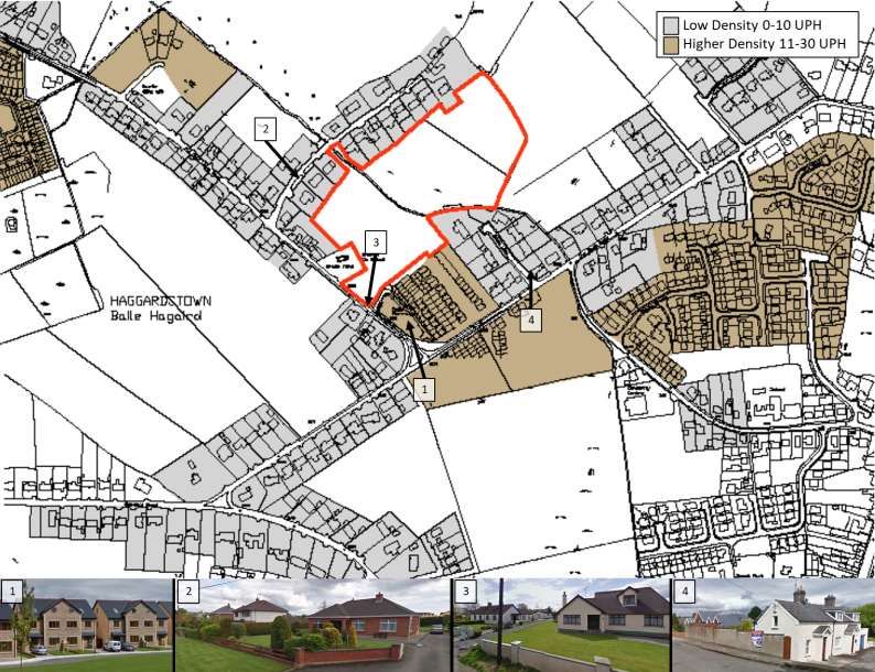
CONTENTS

1    INTRODUCTION & RATIONALE                 3

2.   DEMOGRAPHIC & SOCIO-ECONOMIC CONTEXT      5

3.   SITE & NEIGHBOURHOOD CONTEXT             14

4.   STATEMENT OF CONSISTENCY WITH NATIONAL

     & REGIONAL PLANNING POLICY               18

5.   STATEMENT OF CONSISTENCY WITH LOCAL
     PLANNING POLICY                          41

6.   CONCLUSION                               45

APPENDIX A                                    46

REFERENCES                                  48

                                                   2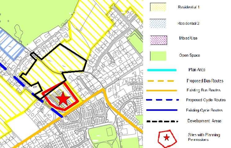
1.     INTRODUCTION & RATIONALE

On behalf of the applicant, McCaughey Homes Ltd., this report accompanies this
planning application to An Bord Pleanála in relation to a proposed Strategic Housing
Development at Old Golf Links Road, Blackrock, Dundalk, Co. Louth, in accordance
with the Planning and Development (Housing) and Residential Tenancies Act 2016.

The proposed residential development will consist of 166 no. residential units
comprising 67 no. 1-3 bed apartments/duplexes within 12 no. 2-3 storey blocks, and
99 no. 2-storey, 2-4 bed, semi-detached/detached/terraced houses. Provision of a
crèche (c.250 sq.m), bike and bin stores. 294 no. car parking spaces. Provision of
open spaces and completion of street network and link roads. Main access to Old
Golf Links Road via existing estate road shared with the adjoining Cois Farraige
estate. Separate access off Old Golf Links Road to serve 4 of the proposed houses.
Pedestrian/cyclist access via Tuite’s Lane and extension of public footpath along Old
Golf Links Road (on land in ownership of applicant). All associated site development
works, landscaping, boundary treatments and services provision.

This report provides a Statement of Consistency which demonstrates that the
proposal is consistent with the relevant national planning policy, guidelines issued
under Section 28 of the Planning and Development Act 2000 (as amended).

The report also demonstrates consistency with the key policies and development
management standards outlined in the Dundalk & Environs Development Plan 2009-
2015 (as extended).

It is acknowledged that this proposed strategic housing development application on a
residentially zoned site may require a Material Contravention of the Dundalk &
Environs Development Plan.

As per Variation Number 1 (Core Strategy) of the Development Plan the subject
lands are located within Core Strategy Phase 2, and not Phase 1. Under Policy CS2
the Core Strategy requires the development of at least 75% of Phase 1 lands before
development within Phase 2 can be considered. That level of development within
Phase 1 has not occurred over the life of the Development Plan and the continued
implementation of Policy CS2 is restricting the sustainable development of the other
development areas within the Dundalk Environs including the well-established suburb
of Blackrock where the application site is located.

Under Section 5(6), the Planning and Development (Housing) and Residential
Tenancies Act, 2016, the Board may grant planning permission for the proposed
strategic housing development notwithstanding the material contravention.

This application includes a Statement on Material Contravention Statement outlining
how and why the Board should grant permission in accordance with Section 37(2)(b)
of the Planning and Development Act 2000 (as amended).

There is also broad support from the planning authority for the development of this
site for a mixed residential scheme, as evidenced in the report submitted to the
Board at pre-application stage.
This strategic housing development can provide for the housing needs of a broad
range of household types including professionals working nearby in the main
employment centres along the Inner Relief Road (e.g. PayPal), students at Dundalk
Institute of Technology, young families looking for starter homes, and empty nesters
interested in downsizing to more manageable accommodation which in turn will
create an additional supply of larger family houses in the area.

As such it is requested that An Bord Pleanála have regard to the justification set out
within this Statement and the Material Contravention Statement which demonstrate
the following:

   (1) The proposed development is consistent with national planning policy and
       guidelines, regional planning policy and local planning policy;
   (2) In accordance with Section 37(2)(b) of the Planning & Development Act,
       despite the material contravention of the Development Plan, permission can
       be granted given that the proposed development is of strategic importance
       and accords with current national and regional planning policy.

                                                                                     4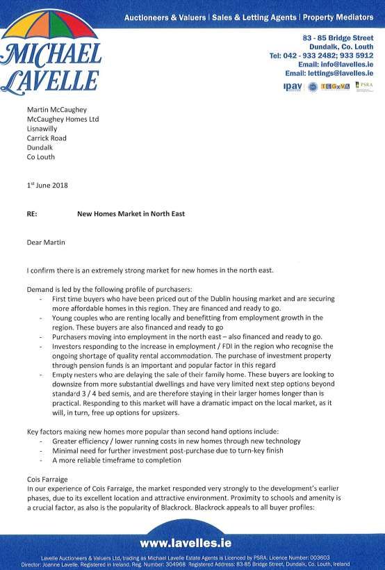
2.     DEMOGRAPHIC & SOCIO-ECONOMIC CONTEXT

The following section provides an analysis of demographic and socio-economic
trends in the Dundalk and Blackrock areas since the adoption of the Core Strategy in
2011, in order to understand the reasons for the current housing needs crisis in the
town and how the current proposal for strategic housing development can help
address same.

Overview of Dundalk

Dundalk is strategically located along the Eastern Economic Corridor mid-way
between Dublin and Belfast. Dundalk benefits from high quality road and rail
infrastructure linking the area to Dublin, Belfast and the rest of Ireland. The M1
motorway links Dundalk to Dublin, George Best and Belfast airports within
approximately an hour drive. This motorway also links the town to 3 deep seaports.

Dundalk is one of the largest towns in Ireland with a population in excess of 39,000.
It has an abundance of skilled labour and a highly educated workforce supplied by
Dundalk Institute of Technology (DkIT). The area is supplied by high speed
broadband.

All of this makes Dundalk extremely attractive to multinational corporations (MNC)
for foreign direct investment (FDI). The Industrial Development Agency (IDA) has
promoted investment in the Dundalk area and has secured a number of MNC to
locate in Dundalk. This has led to the continued growth in population within
Dundalk and surrounding areas.

The Blackrock area is part of the greater Dundalk area. It is a village located to the
south east of Dundalk. It has a population of c. 7,000 people. Blackrock is c. 3km
away from DkIT and c. 5km away from Dundalk town centre.

Population & Socio-Economic Trends

The following sections assess demographic changes which have occurred since the
Core Strategy was adopted, with specific reference to the results of the 2011 and
2016 Census.

Dundalk overall and the Haggardstown Electoral Division (ED) (which is the ED
within which Blackrock is located) are examined.

CSO results show that Dundalk’s population in 2016 was 39,004 a 3% increase from
2011 as shown on the table below.

Blackrock experienced a greater increase in population of 8.5% to 6,932 people in
2016.

                                                                                     5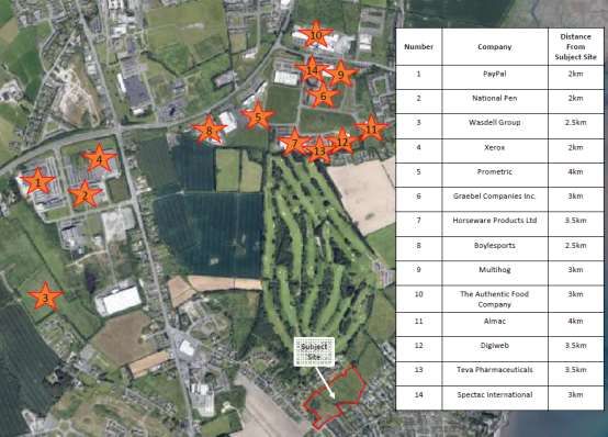
The Louth County Development Plan 2015-2021 expects Dundalk to continue to
grow. They have predicted that the population of Dundalk will be 46,622 by 2021.

Blackrock has also seen an increase in the percentage of the population in the age
cohorts 0-18 and 65+.

Dundalk overall has also seen an increase in the percent of the population between
0-18.

                                                                                 6
Census results show that smaller households (1-4 person) are by far the largest
proportion of households at town and local level.

                                                                              7
In relation to house types the census result show that in both Blackrock and
Dundalk the vast majority are own door houses or bungalows. Only 4% of the units
in Blackrock and 7% in Dundalk are flats or apartments.

In Blackrock 79% of all households are owner occupied compared to 61% in Dundalk
overall. Only 19% of the houses in Blackrock are rented compared to 35% in
Dundalk.

                                                                               8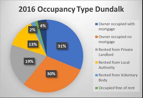
In terms of socio-economic trends, Blackrock has 54% of its population at work, 11%
students and only 5% unemployed compared to Dundalk which has 47% of its
population at work, 13% students and 11% unemployed.

                                                                                  9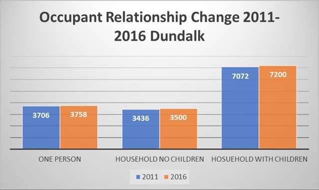
For the current analysis the Socio-economic groups within Blackrock and Dundalk
have been grouped as follows, A-C: employers and managers, higher professionals,
and lower professionals, D-G: non-manual, manual skilled, semi-skilled, and unskilled
and H-Z: own account workers, farmers, agricultural workers, and all gainfully
occupied and unknown.

Blackrock has seen a steady increase in groups A-C and D-G. Group H-Z only had a
slight increase. 48% of the population were in group A-C and 36% were in group D-
G.

Dundalk saw a slight increase across all Socio-economic groups. In Dundalk 28% of
the population are in group A-C, 46% in group D-G and 26% in group H-Z.

Blackrock has a highly educated population with 38% of the people with an ordinary
Bachelor Degree or higher compared to Dundalk with 23% and Ireland with 29%.

                                                                                   10
Economic Growth
At the same time as the population of Dundalk has grown and diversified, the town
has emerged out of the economic recession and remains the main hub of economic
activity in the North-east of Ireland.
The town is home to a number of large international companies which provide
financial services, engineering, pharmaceutical and technology. Dundalk also has
many Irish companies including Irish Life, Digiweb, Boyle Sports, Glen Dimplex,
Kerry Group and Ovelle.
The following employment developments are noted:
In 2012 PayPal opened a European Operations Centre in Dundalk and
currently employs over 1,000 staff.
National Pen, a leading global provider of personalised marketing
merchandise is understood to employ c.1,000 staff.
Prometric, a provider of market-leading test development and delivery
solutions, established its Test Development headquarters in Dundalk in 2011
and currently employs circa 100 people.
Graebel Companies Inc. created 125 new jobs in an EMEA Financial Shared
Services and Operations Centre in Dundalk in 2017.
The pharmaceutical company Wasdell Group announced in 2017 that it plans
to establish a Packaging & Distribution Facility creating 300 jobs over five
years.
Dundalk will also see continued growth from existing companies such as
Coca-Cola, Becton Dickinson, Xerox, Actavis, International Fund Services
(IFS) and Cargotec.
In 2012 it was confirmed that Dundalk had secured 1,326 jobs generated by the IDA.
This was out of 6,570 which were secured by the IDA for the state. Apart from the
major firms such as PayPal the IDA also secures FDI from smaller companies such as
the pet-product company Radio Systems with 56 jobs and Diaceutics which is a
medical software company with 20 jobs.
11IDA Ireland states that it will continue to roll out its building programme across
Dundalk over the coming years. At the year ending 2017 there were 11,469 FDI jobs
created by the IDA in the Border Region which was a 4% increase from 2016.
The IDA also has a site at Mullagharlin, south of Inner Relief Road which is to be
developed as a Science & Technology Park for Bio-Pharmaceuticals. Planning
Permission has been obtained for two Bio Pharmaceutical facilities. Up to an
additional 1,000 jobs can be achieved once investment is secured.
Planning Implications
The population of Dundalk is growing and diversifying.
A main driver has been the growth of employment opportunities in Dundalk which
in turn is creating significant and currently unfulfilled housing demand from workers
moving to the town.
In a 2017 article published on the MyHome.ie website titled “Lack of rental property
affecting foreign direct investment in Ireland” Louise Phelan (Vice President of western,
central and eastern Europe, Ireland, the Middle East and Africa at PayPal) stated that
“the lack of available housing means that staff at PayPal (in Dundalk) are being asked to
offer rooms to new employees who cannot find accommodation.”
Ms Phelan says that this problem is now at crisis point and that further Foreign
Direct Investment will be lost if it is not addressed. If accommodation is not available
for employees then companies will take their business elsewhere.
In an interview with the Dundalk Leader in 2017 Kevin Adams (Training Co-
ordinator at National Pen) stated that “workers are actually turning down jobs in the
company due to the lack of suitable houses to rent around town”. Other workers are
being forced to live in areas such as Newry and Portadown and commuting to
Dundalk each day with this having a negative impact on the local economy.
At the same time Dundalk Institute of Technology (which has c.5,000 students and
500 members of staff) is being impacted by a “chronic shortage of houses for students to
rent” in Dundalk. With students competing with employees from PayPal and other
firms for accommodation DKIT has effectively become “a commuter college” with
students travelling long distances to get to and from college every day.
The failure of housing supply to meet increased demand is further reflected in the
increase in property prices and rents in recent years. The latest 2018 Q1 House
Price Report provided by Daft.ie indicates that the average price of a house in
County Louth is now €210,074 which represents a year on year increase of 7.1% and
a 64.7% increase from the third quarter of 2013 when nationally the average asking
price reached its lowest point.
The above analysis demonstrates that household numbers are growing, household
sizes are decreasing and household types are diversifying. However the number and
range of housing types available in Dundalk do not meet these existing growing
demands.
12For instance, despite 1 and 2 person households representing the vast majority of
household sizes in Dundalk, apartments represent only a fraction of the existing
housing stock.
Empirical and anecdotal evidence suggests a significant and growing housing crisis in
Dundalk which needs to be addressed by increased and diversified residential output
particularly in sustainable locations which are both convenient to the resident in
terms of getting to work or education and are well served by existing social
infrastructure.
As the below map demonstrates, the subject site, is strategically located close to the
majority of the main employment providers noted above which are principally
located along the Inner Relief Road within 5 minutes’ drive of the site. DKIT is also
located in close proximity.
Development of this site for mixed residential types can help address the
considerable housing demand crisis which the town is currently experiencing.
The current proposal provides a sustainable residential mix. 41% of the units are 1-
2-bed apartments. 50% are 3-bed houses. These will appeal to a broad number of
household types including first time buyers, young professionals/couples looking to
buy or rent, students and older people/empty nesters /specific needs
accommodation. Lifetime family homes comprising larger 3 and 4 bed houses are
also provided.
This view is also confirmed by estate agents who have identified a broad range of
buyers making up the current demand, reflecting the household trends identified in
the census results. A letter from Lavelle’s to the applicant in this regard is attached
as Appendix A to this report.
133. SITE & NEIGHBOURHOOD CONTEXT
The following section summarises the positive attributes of the site as a sustainable
location for a strategic housing development as proposed.
This site is located along the Old Golf Links Road, on a site area of c.4.8 ha. It is
located within the well-established suburb of Blackrock c.4km from the centre of
Dundalk.
Golf Links Road is currently a low density residential area. Tuite’s Lane and Old
Golf Links Road to the north-west and west comprise mainly detached dwellings on
large plots, as also occurs to the north-east and east at The Hamiltons and along
Rock Road.
To the south and south-east the range of housing typologies broadens somewhat
with semi-detached and terraced housing at the more recently developed Gort na
Glaise and Cois Farraige residential developments, the latter of which was developed
by the applicant.
The existing residential areas are all below 30 units per ha while along the local
roads are typically detached dwellings on large plots with densities well below 10
units per ha.
Furthermore the immediate area has seen little recent residential development. Due
to the Core Strategy restriction residential zoned greenfield sites have not been
brought forward for planning.
Aside from the granting of extensions of durations to older permissions for
residential development west of the Dublin Road in the Haggardstown area (where
works had previously commenced), the only new residential permissions of note in
the area has been at the Fairways centre located near the junction of the Old Golf
Links Road and the Dublin Road. Due to the mixed use nature permission can be
granted on those under the current Core Strategy.
14In this regard we note permission LCC Reg. Ref.: 17440 which comprises an
extension of the Fairways Hotel and the construction of 40 no. houses and 8 no.
apartments.
Despite the low density and quantum of residential development this established
suburb is very well provided for in terms of social infrastructure. We note the
following:
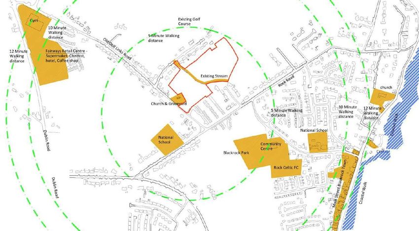
Education:
The subject site is a 3-minute walk to St. Francis National School.
The subject site is a 9-minute walk to Blackrock National School.
The subject site is a 4-minute drive to Scoil Fhursa (National School).
The subject site is a 4-minute drive to Dundalk Institute of Technology.
The subject site is a 6-minute drive to Ó Fiaich Institute of Further Education.
Local Retail and Services:
Fairways Retail Centre is a 10-minute walk from the subject site. This centre
has a SuperValu, Costa Coffee and Hotel. Beside this there is a Gym and a
Topaz garage.
The subject site is a 12-minute walk from Blackrock main street which has a
range of shops and services including Centra, Londis, Post Office, Pharmacy,
Medical Centre, Pubs, Cafes and Restaurants.
Recreation & Amenity:
Blackrock Park, Community Centre and Rock Celtic Football Club is
approximately an 8-minute walk from the subject site.
The subject site is a 12-minute walk from Blackrock Beach.
There is a church and graveyard to the south boundary of the site.
The proposed development will be located at the heart of this neighbourhood and
within walking/cycling distance of a wide range of services and facilities for future
residents. There is a good footpath network throughout the area (with the
exception of a short stretch along the boundary with the historic graveyard) which
the proposed development will connect directly to via the entrance shared with the
adjoining Cois Farraige scheme.
A stream divides the subject site crossing east to west which will be developed into a
new open space. This is an important provision as it will provide cyclists and
pedestrian with a more direct route to the Fairways neighbourhood centre to the
north-east via Tuite’s Lane and the Old Golf Links Road.
The proposed development will also provide a mix of residential types which will
create a sustainable new community that will support the existing services and
provide demand for additional services.4. STATEMENT OF CONSISTENCY WITH NATIONAL &
REGIONAL PLANNING POLICY
The key national and regional policies and guidelines (including Section 28
Guidelines) relevant to the proposed development are as follows:
Project Ireland 2040 - National Planning Framework (2018);
Draft Regional Spatial and Economic Strategy for the Eastern and Midland Region
(RSES);
Guidelines for Planning Authorities on Sustainable Residential Development in Urban
Areas (2009), and the accompanying Urban Design Manual;
Delivering Homes, Sustaining Communities (2008) and the accompanying Best
Practice Guidelines- Quality Housing for Sustainable Communities;
Quality Housing for Sustainable Communities (2007);
Design Standards for New Apartments (2015);
Design Manual for Urban Roads and Streets (2013);
Guidelines for Planning Authorities on Childcare Facilities (2001);
Smarter Travel – A New Transport Policy for Ireland (2009-2020);
The Planning System and Flood Risk Management (2009).
4.1 PROJECT IRELAND 2040 - NATIONAL PLANNING FRAMEWORK
(2018)
The National Planning Framework (NPF) is the Government’s plan to cater for the
extra one million people anticipated to be living in Ireland by 2040. The Eastern and
Midland Region (including Dublin) will, by then, be a Region of around 2.85 million
people, at least half a million more than today.
Strategic Policies
The NPF Strategy includes the following aims and objectives relevant to the current
proposal:
Developing a new region-focused strategy for managing growth in order to
build stronger regions and accessible centres of scale.
Making better use of under-utilised land and providing higher housing
densities, better serviced by existing facilities and public transport.
Increasing the proportion of more compact forms of growth in the
development of settlements to bring new life and footfall, contribute to the
viability of services, shops, and public transport, increase housing supply, and
enable more people to be closer to employment and recreational
opportunities, as well as to walk or cycle more and use the car less.
Consolidating developments which grew rapidly in the past decade.
Promoting self-sustaining economic and employment based developments
met with adequate housing. This will be achieved through the continuation of
balanced population and employment growth.
Deliver at least 40% of all new homes nationally, within the built-up footprint
of existing settlements. Within the Eastern and Midland Region 30% of allnew housing to be delivered within the existing urban footprints outside
Dublin.
The NPF highlights the unique role that Dundalk will play in the future
development of Ireland and the need for significant investment, residential
development and population growth in this key growth centre.
Dundalk is supported for development within the context of the Dublin-
Belfast economic corridor and the significant cross border interactions
with Newry as a driver for regional development.
The NPF highlight both Dundalk and Drogheda as “key centres on the
Drogheda-Dundalk-Newry cross-border network and in the context of
the Dublin-Belfast economic corridor” and indeed their importance for
regional development.
National Policy Objective (NPO) 2b identifies the regional role of
Dundalk and which is to be supported in the Regional Spatial and
Economic Strategy for the Eastern and Midland Region.
NPO 44 seeks to further support and develop the economic potential of
the Dublin-Belfast Corridor and in particular the core Drogheda-
Dundalk-Newry network and to promote and enhance its international
visibility.
Section 8.3 supports the planning and development of large centres of
population and employment including Dundalk along the main economic
corridor.
Figure 8.2 identifies the need for Dundalk to develop critical mass to
compete with other larger cities.
Section 3.2 promotes a focused approach to the compact, sequential and
sustainable development of Dundalk.
Section 3.2 states that it will be necessary to prepare co-ordinated
strategies for Dundalk (and Drogheda) at both regional and town level to
ensure it had the capacity to grow sustainably and secure investment as a
key centre on the Drogheda-Dundalk-Newry cross-border network.
Sustainable Residential Development
Chapters 4 & 6 of the National Planning Framework also outlines a number of
National Policy Objectives to provide for “People, Homes and Communities” and
“Stronger Urban Places”:
NPO4 promotes the creation of attractive, liveable, well designed, high
quality urban places that are home to diverse and integrated communities
that enjoy a high quality of life and well-being. The proposed development
achieves this objective in providing a mixed residential scheme of houses,
apartments and duplexes within an attractive layout provided with open
spaces and access to a range of existing social infrastructure within walking
distance including schools, shops, sports clubs, etc. The development will
attract a diverse range of household types including single owners, couples,
small and large families, and empty nesters.
19 NPO6 promotes new developments with “enhanced levels of amenity and
design quality, in order to sustainably influence and support their surrounding area.”
The proposed development is designed around a number of key amenities
including a new central open space and with views to the adjoining historic
graveyard. A creche is also centrally located within the development.
Permeability through the site is provided for pedestrians and cyclists.
NPO 28 promotes a more diverse and socially inclusive society that targets
equality of opportunity and a better quality of life for all citizens, through
improved integration and greater accessibility in the delivery of sustainable
communities and the provision of associated services. The mixed residential
housing typology proposed will facilitate a diverse new community of various
household types and sizes.
NPO 30 seeks to meet the needs and opportunities of an ageing population.
Again the provision of a broad range of housing typologies provides a unique
opportunity in the Blackrock area for older residents currently within large,
empty family homes to downsize to an apartment or smaller house within the
proposed development, and still remain living within their community.
NPO 33 prioritises the provision of new homes at locations that can support
sustainable development and at an appropriate scale of provision relative to
location. As outlined in this Statement of Consistency and in the Design
Report prepared by DWD Architects, the proposed location within an
established and well serviced residential community is wholly sustainable.
Furthermore the quantum and mix of residential development is progressive
and suitable for the area.
NPO 34 supports the provision of lifetime adaptable homes that can
accommodate the changing needs of a household over time. The proposed
development includes a range of house types which have the potential to be
adaptable to developing households, with the potential for attic conversion
and rear extensions to the smaller houses to facilitate an expanding family.
Equally with the smaller houses there is the potential to convert an area
downstairs to an additional bedroom to facilitate mobility impaired residents
in later life.
NPO 35 promotes increased residential density in settlements, through a
range of measures including infill development schemes. The proposed site is
located within an established residential area surrounded by housing. It is
proposed to be developed at a density of over 36 units per ha and with a
range of housing types including 40% apartments. The proposed
development represents a significant progression in density and mixed
housing for the area which is currently characterised by low density,
predominantly detached housing along the Old Golf Links Road.
Overall the proposed development seeks to deliver an appropriate form and scale of
residential development on a zoned and serviced site located within the suburban
settlement of Blackrock in the Dundalk Environs and which is proximate to
employment opportunities, existing services and facilities. The proposed
20development will help create critical mass to support local shops, schools, retail
services and public transport in the Blackrock area.
This development involves more efficient use of zoned and serviced land with
increased density and mix of housing types. This development is located within
walking and cycling distance of major employment areas, social infrastructure and
Blackrock Village which will reduce car dependency. The development will promote
further consolidation in the area and will supply extra housing to support economic
growth.
Development of these lands is considered to be fully in accordance with the
recommendations of the NPF.
4.2 DRAFT REGIONAL SPATIAL AND ECONOMIC STRATEGY FOR
THE EASTERN & MIDLAND REGION 2019-31
The Eastern and Midland Region covers the counties of Longford, Westmeath,
Offaly, Laois, Louth, Meath, Kildare, Wicklow, and Dublin.
The draft Regional Spatial and Economic Strategy (RSES) is a strategic plan and
investment framework to shape the future development of the eastern region to
2031 and beyond. Its vision is to create a sustainable and competitive region that
supports the health and wellbeing of all people and places with access to quality
housing, travel and employment opportunities for all.
The draft RSES supports the implementation of the NPF, National Development Plan
(NDP) and the economic policies and objectives of the Government and provides a
long term strategic planning and economic framework for the development of the
region.
In accordance with the NPF the RSES promotes the development of Dundalk as both
a Regional Growth Centre and key urban centre along the Dunlin-Belfast Economic
Corridor. Dundalk is identified as a self-sustaining regional driver to deliver targeted
and sustained development in order to grow to city scale and achieve a population of
c.50,000 by 2031.
The subject development seeks to provide for residential development on a key site
within the established suburb of Blackrock, to increase densities and urban
consolidation close to existing services and facilities including schools, shops, leisure
and open spaces. The proposed development therefore is compliant with the policies
and objectives of the RSES in this regard.
214.3 GUIDELINES FOR PLANNING AUTHORITIES ON SUSTAINABLE
RESIDENTIAL DEVELOPMENT IN URBAN AREAS, 2009
The guidelines set out the key planning principles to be reflected in development
plans and local area plans, to guide the preparation and assessment of planning
applications for residential development in urban areas.
The Guidelines elaborate a range of high-level aims for successful and sustainable
residential development in urban areas. These are assessed against the proposed
scheme as follows:
Prioritise walking, cycling and public The application site will create new
transport, and minimise the need to use linkages with the wider
cars; pedestrian/cycle network connecting
to local services with schools, retail
and recreational facilities within 5-10
minutes’ walk.
Deliver a quality of life which residents The scheme has been designed to the
and visitors are entitled to expect, in highest residential standard. We note
terms of amenity, safety and that all units have dual aspect with
convenience; access to private garden space
meeting and exceeding minimum
standards. In terms of safety, open
space will be passively surveilled and
pedestrian priority given to these
public areas.
Provide a good range of community and The development will consist of
support facilities, where and when they residential units with a crèche facility.
are needed and that are easily The development is well located in
accessible; relation to existing educational,
sports and retail services in the
neighbourhood. The scheme
therefore does not warrant additional
services on site.
Present an attractive, well-maintained The layout of development has been
appearance, with a distinct sense of designed around a number of new
place and a quality public realm that is public open spaces and principally the
easily maintained; main open space along the open
stream running through the site.
Additional open space is provided as
a buffer to the historic graveyard and
the street layout proposed allows for
new views of the graveyard from
within the scheme. The landscape
strategy also allows for an additional
future access via the historic
graveyard (currently in separate
private ownership).
22A series of distinct residential
character areas are provided, defined
by typology, layout, and elevational
treatments.
Are easy to access for all and to find The road/footpath network extends
one’s way around; from the main access connecting to
the Old Golf Links Road via the
adjoining Cois Farraige scheme. A
variety of character areas are
proposed as noted above.
The layout is logical and wayfinding
uncomplicated. The main open space
presents a new east-west
pedestrian/cyclist route through the
site and a new public connection
between Tuite’s Lane and Old Golf
Links Road.
Promote the efficient use of land and of The proposal seeks to import best
energy, and minimise greenhouse gas practice construction/engineering
emissions; techniques and use of energy efficient
materials to maximise energy capacity
and minimise impacts of climate
change in accordance with current
buildings regulations.
Provide a mix of land uses to minimise The site is zoned primarily for
transport demand; residential development as is
proposed.
The scheme is located close to the
existing and planned services
including local retail, schools, sports
clubs, and leisure all within 5-10
minutes’ walk.
Promote social integration and provide A range of unit sizes is proposed for
accommodation for a diverse range of the scheme, ranging from 2/3/4-
household types and age groups; bedroom apartments and houses.
A variety of household types will be
catered for including young
professionals working in the main
employment centres along the Inner
Relief Road, students at Dundalk
Institute of Technology, young
families looking for starter homes,
and empty nesters interested in
downsizing to more manageable
accommodation.
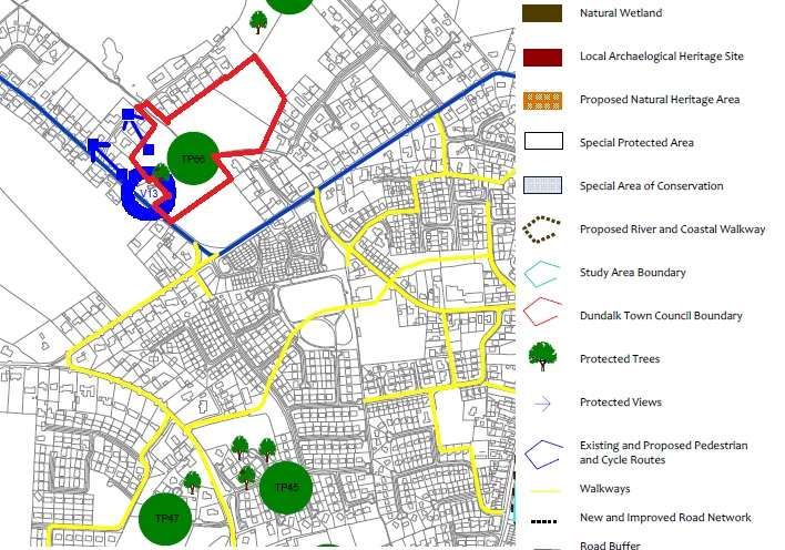
Enhance and protect the green The proposed design protects the
infrastructure and biodiversity; and existing stream through the site and
provides a public open space along its
23banks.
The mature planting around the
historic graveyard will also be
protected.
Enhance and protect the built and The site of the proposed
natural heritage. development is located adjacent to
Recorded Monument LH012-014001
(Church) and LH012-014002
(Graveyard). Recorded Monuments
LH012-063 and LH012-011 (Local
tradition of a souterrain) also lie
within the area of the proposed
development.
An archaeological assessment
(geophysical survey and test trenching
under licence) was carried out on the
site at design stage in order to
identify any potential archaeological
constraints within the site.
As a result of the archaeological
assessment it is recommended that as
a condition of any planning
permission that all archaeological
features and deposits identified be
fully excavated and recorded prior to
commencement of development. In
addition, it is also recommended that
all topsoil stripping associated with
the proposed development be
archaeologically monitored in order
to determine the presence/absence of
any additional archaeological features
or deposits, most notably one or
more souterrains.
The Guidelines support a plan-led approach to the location, scale, and nature of
major residential development, as per the Planning and Development Act.
A sequential approach to the development of land is recommended with zoning to
extend outwards from the centre of an urban area, and undeveloped closest to the
core and public transport routes being given preference.
The Guidelines promote urban design to create places of high quality and distinct
identity, to provide connectivity, permeability, safety, legibility, and sense of place.
In this regard, the Guidelines are accompanied by a Design Manual (discussed below)
which demonstrates how design principles can be applied in the design and layout of
new residential developments, at a variety of scales of development and in various
settings.
24To ensure sustainable communities the Guidelines stress that community facilities
are also to be provided for.
In relation to schools we note the following located in the immediate area:
St. Francis National School, Blackrock
Scoil Na Gcreachacha Dubha primary school, Blackrock.
Scoil Fhursa, primary school, Haggarstown
A number of post primary schools are located in Dundalk including Dundalk
Grammar School, St. Vincent’s, Pobailcholáiste Chú Chulainn, Colaiste Rís and St.
Mary’s College.
In relation to childcare facilities, a crèche is included with the current scheme and
which is assessed in detail below.
In relation to community centres, healthcare facilities and neighbourhood centre
uses we note the proximity of the development to such services in the Blackrock
area.
In relation to density the subject lands are considered “Outer Suburban /
‘Greenfield’” being open lands on the periphery of a large town. The Guidelines
recommend minimum net densities of at least 35 units per ha should be achieved and
should involve a variety of housing types where possible.
The current proposal is at a net density of 36.5 units per ha which is well above the
existing densities in the area. The density is calculated based on a net site area
which excludes the main link road through the site which will provide the potential
for future connection to the adjoining undeveloped residential lands to the north-
east. This calculation of net site area is in accordance with Appendix A of the
Guidelines.
Furthermore, a sustainable mix of housing units are proposed including apartments, 2
and 3 bedroom houses.
The proposed development is considered in broad compliance with the objectives of
these national guidelines.
4.4 URBAN DESIGN MANUAL – A BEST PRACTICE GUIDE, 2009
The Urban Design Manual is the accompanying document to the Sustainable
Residential Development in Urban Areas document which provides policy guidance
for the creation of successful neighbourhoods having regard to the 12-point criteria.
The proposal complies with the following design criteria:
251. Context –How does the development respond to its surroundings?
The development seems to have evolved The proposed development responds
naturally as part of its surroundings. positively to the adjoining residential
areas. It utilises existing road
connections and provide new
pedestrian/cyclist connections through
the site and for future connection to
residential lands to the north-east.
The layout responds to and respects the
natural characteristics of the site
particularly the stream which will
become part of a new linear open space,
and the historic graveyard which will be
framed with new vistas from the
development.
Appropriate increases in density respect
the form of buildings and landscape The proposed development significantly
around the site’s edges and the amenity increases the density and mix of housing
enjoyed by neighbouring users. typology compared to that existing in
Form, architecture, and landscaping have the area whilst achieving a scheme that
been informed by the development’s is attractive, contemporary and does not
place and time. impact the amenity of adjoining
residential areas.
The development positively contributes The existing character of the area is of
to the character and identity of the predominantly low density own door
neighbourhood. housing with more recent developments
providing a broader range of typologies
including terraced housing.
The current proposal improves again on
the range of housing types providing for
own door housing and apartments.
Appropriate responses are made to the Where existing natural mature
nature of specific boundary conditions. boundaries exist with properties to the
north-west and east these will be
retained and enhanced so as to provide
a natural buffer with existing rear
gardens. The scheme will remain open
to the south-east in order to integrate
with the adjoining Cois Farraige scheme.
The soft buffer with Haggardstown Old
Graveyard will be retained and
enhanced.
262. Connections – How well connected is the new development
There are attractive routes in and out for The principal access to the development
pedestrians and cyclists. will be via the existing road from Old
Golf Links Road which also serves the
Cois Farraige scheme. This road
provides access to the local national
school Blackrock Park and Blackrock
village all within 5-10 mins walk.
Streets into the various character areas
will branch off a main access road which
will bridge the stream and central open
space at one location only, and will run
to the north-eastern boundary providing
the opportunity for future access to
adjoining residential lands.
The central spine of open space will
provide pedestrian/cyclist connectivity
east-west through the site and with a
connecting leading out to Tuite’s Lane to
the north-west which in turn provides
an additional connection to the Old Golf
Links Road with the Fairways
neighbourhood centre and gym.
The development is located in or close to As noted above the scheme is located
a mixed-use centre. equidistant from the Fairways
Neighbourhood Centre and Blackrock
Village, both c.10 mins walk.
.
The development’s layout makes it easy A bus service is not considered
for a bus to serve the scheme. necessary given the size of the
development.
There are Bus Eireann services in the
wider area – the 100 (Drogheda-
Dundalk) and 168 (Dundalk-Annagassan)
services operate along the Dublin Road
10 mins walk to the south-west with a
stop at Sexton’s Bar.
The layout links to existing movement Pedestrian permeability connects
routes and the places people will want to directly to the existing public footpath
get to. network along Old Golf Links Road and
Tuite’s lane.
The scheme also includes for extension
to the public footpath along Old Golf
Links Road.
Appropriate density, dependent on The density of 36.5 units per ha (Uph)
location, helps support efficient public accords with national guidelines for an
transport. outer suburban location.
273. Inclusivity – How easily can people use and access the development?
New homes meet the aspirations of a The range of house types will facilitate
range of people and households. a very broad range of homeowners
including individuals, couples, small
families, and empty nesters.
Design and layout enable easy access by The proposal has been designed for
all. ease of access throughout the site in
accordance with Part M of the building
regulations.
There is a range of public, communal, The scheme will provide a number of
and/or private amenity spaces and public open spaces include a central
facilities for children of different ages, spine open space along the stream and
parents, and the elderly. a second open space adjacent the
graveyard.
Areas defined as public open space that The open spaces will be publicly
have either been taken in charge or accessible. Crossings to these spaces
privately managed will be clearly defined, will be denoted by a change in the
accessible and open to all. surface treatment.
New buildings present a positive aspect The layout is designed to maximise
to passers-by, avoiding unnecessary visual and physical fluidity throughout
physical and visual barriers. the scheme and will not hinder
movement.
4. Variety – How does the development promote a good mix of activities?
Activities generated by the development The proposal will significantly improve
contribute to the quality of life in its the housing mix of the area and will
locality. increase population creating additional
demand for educational, sports and
retail services all of which are provided
close to the development.
Uses that attract the most people are in The crèche, playground and the variety
the most accessible places. of open spaces are strategically located
within the scheme and will be easily
accessible to residents.
Neighbouring uses and activities are The immediate area is characterised by
compatible with each other. residential uses; the proposed use is
compatible with the surrounding area.
Housing types and tenure add to the A variety of houses and apartments are
choice available in the area. provided which will further improve
the range of unit types in the area
available to various household types.
Please refer to the accommodation
schedule for more information.
Opportunities have been taken to The scheme is not of a size that would
provide shops, facilities and services that warrant a new local retail centre and
complement those already available in noting the proximity to the Fairways
the neighbourhood. and Blackrock village. The proposed
layout encourages connection to these
centres via sustainable means (walking
and cycling).
285. Efficiency - How does the development make appropriate use of
resources, including land?
The proposal looks at the potential of The overall average density of 36.5
higher density, taking into account units/ha is considered wholly
appropriate accessibility by public appropriate for this site given the
transport and the objectives of good outer suburban location, the existing
design. character of the area and proximity to
social infrastructure.
Landscaped areas are designed to Significant public open space will be
provide amenity and biodiversity, protect provided across the entire scheme
buildings and spaces from the elements incorporating SuDS, promoting
and incorporate sustainable urban biodiversity, and providing residential
drainage systems. amenity.
Buildings, gardens, and public spaces are All rear gardens will enjoy sufficient
laid out to exploit the best solar daylight and sunlight provisions
orientation. throughout the day. Whilst the public
open spaces are all overlooked by
adjoining residential streets there is
sufficient set back to ensure that these
spaces enjoy optimum sunlight
provision.
The scheme brings a redundant building n/a
or derelict site back into productive use.
Appropriate recycling facilities are Each unit will undertake its own
provided. recycling with collection by municipal
services. Communal bin stores for the
apartment elements will be provided.
6. Distinctiveness - How do the proposals create a sense of place?
The place has recognisable features so The main characteristics that define
that people can describe where they live the site are the stream that runs
and form an emotional attachment to through the site and the location
the place. adjoining the graveyard.
The proposed design incorporates
these two features providing a scheme
that encircles a new linear open space
along the stream, while to the
southwest a visual link to the graveyard
along a new street is provided and a
second open space providing an
attractive buffer.
The scheme is a positive addition to the The site is currently vacant. The
identity of the locality. proposal will provide an appropriate
scale and quantum of residential
development on a key site within the
Haggradstown/Blackrock area.
29The layout makes the most of the The proposed layout adapts to the site
opportunities presented by existing boundaries and its constraints, with the
buildings, landform, and ecological scheme broken into a number of
features to create a memorable layout. character areas with the layout
responding to the stream, the
graveyard, and adjoining properties.
The proposal successfully exploits views There are limited views into the site
into and out of the site. due to the existing boundary planting
and the graveyard along Old Golf Links
Road. The site will be opened from
the main access to the south and will
address the access road and the public
road. The scheme will also become
more visible from Tuite’s lane to the
north west with the opening up of a
new pedestrian connection.
There is a discernible focal point to the The main linear open space along the
scheme, or the proposals reinforce the stream will be the main focal point that
role of an existing centre. unifies the scheme.
7. Layout - How does the proposal create people friendly streets and
spaces?
Layout aligns routes with desire lines to Pedestrian permeability across the
create a permeable interconnected scheme and between adjoining
series of routes that are easy and logical residential areas and open spaces is a
to navigate around. key design outcome with connection
to the existing public footpath network
along the public roads a key concern
so as to ensure that local services are
within short walking distance.
The layout focuses activity on the streets The scheme provides a series of
by creating frontages with front doors streets and avoids long, straight
directly serving the street. stretches in order to reduce traffic
The streets are designed as places speeds in accordance with DMURS.
instead of roads for cars, helping to
create a hierarchy of space with less The streets will be co-shared with
busy routes having surfaces shared by cyclists and on the smaller streets
pedestrians, cyclists and drivers. serving a small number of houses will
Traffic speeds are controlled by design operate much like shared surfaces with
and layout rather than by speed humps. residents using the streets to cross
over to open spaces and other houses.
Block layout places some public spaces The open space strategy for the
in front of building lines as squares or scheme creates multiple open space
greens, and some semi-private space to areas of varying uses and sizes. The
the back as communal court. apartment and elderly housing
elements are located around
communal open space courtyards.
308. Public Realm - How safe, secure, and enjoyable are the public areas?
All public open space is overlooked by All spaces are overlooked and
surrounding homes so that this amenity surveilled by surrounding residential
is owned by the residents and safe to streets.
use.
The public realm is considered as a Public realm is integrated into the
usable integrated element in the design design of the development and forms
of the development. part of the wider network of usable
public spaces in the wider area.
Children’s play areas are sited where A children’s play area is provided and
they will be overlooked, safe and centrally located.
contribute to the amenities of the
neighbourhood.
There is a clear definition between Private open space is provided with
public, semi-private, and private space. private gardens for houses and
balconies for the apartments.
Communal open spaces for the
apartments are located in courtyard
settings. Public open spaces are
provided throughout the scheme.
Roads and parking areas are considered Each unit will be provided with
as an integral landscaped element in the adequate parking. Roads and parking
design of the public realm. areas are considered to be part of the
public realm as such they are carefully
soft landscaped and planted to reduce
the harsh effects of hard landscaping.
9. Adaptability - How will the buildings cope with change?
Designs exploit good practice lessons, Proposed house types in the scheme
such as the knowledge that certain include attic space and rear garden
house types are proven to be ideal for private areas that may be suitable for
adaptation. adaptation if required.
Specific 2 storey units are designed
with the ability to convert ground floor
living accommodation into a bedroom
and provide for an accessible
bathroom at ground floor. All 2-story
units are designed for future extension
to the rear and into the attic.
The homes are energy-efficient and Yes, design practices and proposed
equipped for challenges anticipates from materials will militate against the
a changing climate. effects of climate change.
Homes can be extended without ruining Yes, as discussed above.
the character of the types, layout and
outdoor space.
31The structure of the home and its loose Yes, as discussed above.
fit design allows for adaptation and
subdivision, such as the creation of an
annex or small office.
Space in the roof or garage can be easily This can be achieved in the attics of
converted into living accommodation. most house designs proposed.
10. Privacy and Amenity - How does the scheme provide a decent
standard of amenity?
Each home has access to an area of Yes, each unit has its own private open
useable private outdoor space. space in accordance with the minimum
residential standard.
The design maximises the number of All houses are dual aspect and the
homes enjoying dual aspect. majority of the apartments are dual
aspect in accordance with national
guidelines.
Homes are designed to prevent sound All units will be designed to prevent
transmission by appropriate acoustic sound transmission in accordance with
insulation or layout. building regulations.
Windows are sited to avoid views into Adequate separation distance between
the home from other houses or the opposing windows in achieved and
street and adequate privacy is affordable overlooking is not considered an issue,
to ground floor units.
The homes are designed to provide All houses and apartments are
adequate storage including space within designed in accordance with national
the home for the sorting and storage of design standards on storage areas.
recyclables.
11. Parking – How will the parking be secure and attractive?
Appropriate car parking is on-street or Parking will be provided to the front
within easy reach of the home’s front and side of dwelling units.
door.
Parked cars are overlooked by houses, Yes, this will contribute to surveillance
pedestrians and traffic, or stored of the street.
securely, with a choice of parking
appropriate to the situation.
Parking is provided communally to This is provided for at the apartment
maximise efficiency and accommodate and elderly housing elements.
visitors without the need to provide
additional dedicated spaces.
Materials used for parking areas are of Yes, the highest quality materials will
similar quality to the rest of the be used throughout the scheme.
development.
Adequate secure facilities are provided Dedicated bicycle parking is provided
for bicycle storage. for the apartment blocks. Bicycle
parking will be accommodated in the
rear hardens of own door houses.
3212. Detailed Design – How well thought through is the building and
landscape design?
The materials and external design make A variety of materials and treatments
a positive contribution to the locality. that complement the existing character
of the area will be employed.
The landscape design facilitates the use The public open spaces will be
of the public spaces from the outset. provided in tandem with the phasing of
the overall scheme.
Design of the buildings and public space This can be achieved and will be
will facilitate easy and regular provided by the estate management
maintenance. company.
Open car parking areas are considered Communal parking areas will be
as an integral element within the public designed and finished to the highest
realm design and are treated standard.
accordingly.
Care has been taken over the siting of Bin stores for the houses will be
flues, vents, and bin stores. located in the rear gardens.
Communal bin stores for the
apartments will be carefully designed
and will not form a negative visual
element.
4.5 QUALITY HOUSING FOR SUSTAINABLE COMMUNITIES: BEST
PRACTICE GUIDELINES FOR SUSTAINABLE COMMUNITIES, 2007
The Department’s policy statement Delivering Homes, Sustaining Communities,
Guidance provides the overarching policy framework for an integrated approach to
housing and planning. Sustainable neighbourhoods are areas where an efficient use of
land, high quality design, and effective integration in the provision of physical and
social infrastructure combine to create places people want to live in. The policy
statement is accompanied by Best Practice Guidelines that promotes quality
sustainable residential development in urban areas having regard to the following:
promote high standards in the design and construction and in the provision of
residential amenity and services in new housing schemes;
encourage best use of building land and optimal of services and infrastructure in the
provision of new housing;
point the way to cost effective options for housing design that go beyond minimum
codes and standards;
promote higher standards of environmental performance and durability in housing
construction;
seek to ensure that residents of new housing schemes enjoy the benefits of first-rate
living conditions in a healthy, accessible and visually attractive environment; and
provide homes and communities that may be easily managed and maintained.
The following criteria indicate the 7 no. essential requirements new residential
developments should have regard to when carrying out development:
33Socially & Environmentally Appropriate The scheme will provide an appropriate
“The type of accommodation, support mix of 2/3/4 bed houses and apartments.
services and amenities provided should be The proposal seeks to integrate usable
appropriate to the needs of the people to be public open spaces distributed
accommodated. The mix of dwelling type, throughout a number of character areas
size and tenure should support sound social, and all interconnected. All public open
environmental and economic sustainability spaces will be overlooked by adjoining
policy objectives for the area and promote housing.
the development of appropriately integrated
play and recreation spaces.”
Architecturally Appropriate The design and layout of the scheme
“The scheme should provide a pleasant creates a liveable and visually pleasing
living environment, which is aesthetically residential environment.
pleasing and human in scale. The scheme
design solution should understand and The design is appropriate and mindful of
respond appropriately to its context so that the urban edge context, the site
the development will enhance the constraints, and architectural character of
neighbourhood and respect its cultural the adjoining residential areas.
heritage.”
Accessible & Adaptable A single vehicular access will be provided.
“There should be ease of access and Several pedestrian/cyclist connections will
circulation for all residents, including people also be provided.
with impaired mobility, enabling them to
move as freely as possible within and
through the development, to gain access to
buildings and to use the services and
amenities provided. Dwellings should be
capable of adaptation to meet changing
needs of residents during the course of their
lifetime.”
Safe, Secure & Healthy The scheme provides an appropriate
“The scheme should be a safe and healthy layout for pedestrians/cyclists with a
place in which to live. It should be possible dedicated alternative access via Tuite’s
for pedestrians and cyclists to move within Lane available.
and through the area with reasonable ease
and in safety. Provision for vehicular A safe walking and cycling environment
circulation, including access for service will be provided for residents and those
vehicles, should not compromise these travelling through the scheme will be
objectives.” provided.
Affordable The interconnectivity of the scheme will
“The scheme should be capable of being ensure access for all while creating a
built, managed and maintained at walkable environment for inhabitants of
reasonable cost, having regard to the nature the scheme. The continuity of path
of the development.” networks will assist natural way-finding in
the scheme. Public open space shall be
overlooked as far as practicable to
achieve maximum passive surveillance.
34You can also read