BUSHFIRE RISK MANAGEMENT PLAN - Shire of Wandering
←
→
Page content transcription
If your browser does not render page correctly, please read the page content below
Shire of Wandering
BUSHFIRE RISK
MANAGEMENT PLAN
2021-2026

Office of Bushfire Risk Management Bushfire Risk Management (BRM
Plan) reviewed XX Month 20XX
Local Government Council BRM Plan endorsement XX Month 20XX

 The Shire of Wandering Bushfire Management Plan 2021-2026         Page 1
Contents

1.     Introduction ................................................................................................................ 5
     1.1.    Background ............................................................................................................................................ 5
     1.2.    Aim and Objectives ................................................................................................................................ 5
     1.3.    Legislation, Policy and Standards .......................................................................................................... 6
2.     The Risk Management Process ..................................................................................... 8
     2.1.    Roles and Responsibilities ..................................................................................................................... 9
     2.2.    Communication and Consultation .......................................................................................................10
3.     Establishing the Context ............................................................................................ 11
     3.1.    Description of the Local Government and Community Context .........................................................11
     3.2.    Description of the Environment and Bushfire Context .......................................................................15
4.     Asset Identification and Risk Assessment ................................................................... 31
     4.1.    Planning Areas .....................................................................................................................................31
     4.2.    Asset Identification ..............................................................................................................................31
     4.3.    Assessment of Bushfire Risk ................................................................................................................34
5.     Risk Evaluation .......................................................................................................... 36
     5.1.    Evaluating Bushfire Risk.......................................................................................................................36
     5.2.    Risk Acceptability .................................................................................................................................36
     5.3.    Treatment Priorities ............................................................................................................................38
6.     Risk Treatment .......................................................................................................... 39
     6.1.    Local Government Wide Controls .......................................................................................................39
     6.2.    Asset Specific Treatment Strategies ....................................................................................................39
     6.3.    Development of the Treatment Schedule ...........................................................................................40
7.     Monitoring and Review.............................................................................................. 41
     7.1.    Review .................................................................................................................................................41
     7.2.    Monitoring ...........................................................................................................................................41
     7.3.    Reporting .............................................................................................................................................41
8.     Glossary ..................................................................................................................... 42
9.     Common Abbreviations ............................................................................................. 45
10. Appendices ................................................................................................................ 46

The Shire of Wandering Bushfire Management Plan 2021-2026                                                                                        Page 2
Document Control
                             Shire of Wandering Bushfire
 Document name                                              Current version           1.1
                             Risk Management Plan

 Document owner              CEO - Shire of Wandering       Adopted 20/05/2021

 Document location Shire Office                             2026

Document Endorsements
The Shire of Wandering Council endorses that the Bushfire Risk Management Plan (BRM Plan) has been
reviewed and assessed by the Office of Bushfire Risk Management as consistent with the standard for
bushfire risk management planning in Western Australia, the Guidelines for Preparing a Bushfire Risk
Management Plan. The Shire of Wandering is the owner of this document and has responsibility, as far
as is reasonable, to manage the implementation of the BRM Plan and facilitate the implementation of
bushfire risk management treatments by risk owners. The approval of the BRM Plan by Shire of
Wandering Council satisfies their endorsement obligations under State Hazard Plan Fire.

  Local Government                           Representative          Signature              Date
  Shire of Wandering                         CEO                                              20/05/2021

  Version                        Date                       Author                     Section

Publication Information

Wherever a third party holds copyright in material presented in this publication, the copyright remains
with that party. Their permission may be required to use the material.

This document contains Standards Australia Ltd and ISO copyrighted material that is distributed by SAI
Global on Standards Australia Ltd and ISO’s behalf. Standards Australia Ltd and ISO’s material is not for
resale, reproduction or distribution in whole or in part without written permission from SAI Global Ltd:
tel + 61 2 8206 6355 or copyright@saiglobal.com

The Shire of Wandering Bushfire Management Plan 2021-2026                                          Page 3
Local Government Disclaimer

In approving this BRM Plan, the Shire of Wandering is acknowledging the assets that have been identified
and the risk ratings and treatment priorities assigned. Endorsement of the plan is a commitment by the
Shire to work with land owners and managers to address unacceptable risk within the
community. Endorsement of this plan is not committing the Shire to a program of treatment works to be
implemented by others, or an acceptance of responsibility for risk occurring on land that is not owned or
managed by the Shire. 1

1   Guidelines for Preparing a Bushfire Risk Management Plan, November 2015, Page 79

The Shire of Wandering Bushfire Management Plan 2021-2026                                       Page 4

1. Introduction
   1.1. Background
   Under the State Hazard Plan Fire an integrated Bushfire Risk Management (BRM) Plan
   is to be developed for local government areas with significant bushfire risk. This BRM
   Plan has been prepared for the Shire of Wandering in accordance with the
   requirements of the Guidelines for Preparing a Bushfire Risk Management Plan (the
   Guidelines) from the Office of Bushfire Risk Management (OBRM) within the
   Department of Fire and Emergency Services (DFES). The risk management processes
   used to develop this BRM Plan are aligned to the key principles of AS/NZ ISO
   31000:2009 Risk management –Principles and Guidelines and those described in the
   National Emergency Risk Assessment Guidelines. This approach is consistent with
   State Emergency Management (SEM) Policy and SEM Prevention and Mitigation
   Procedure 1.

   This BRM Plan is a strategic document that facilitates a coordinated approach towards
   the identification, assessment and treatment of assets exposed to bushfire risk. The
   Treatment Schedule sets out a broad program of coordinated multi-agency treatments
   to address risks identified in the BRM Plan. Government agencies and other land
   managers responsible for implementing treatments participate in developing the BRM
   Plan and Treatment Schedule to ensure treatment strategies are collaborative and
   efficient, regardless of land tenure.

   1.2. Aim and Objectives
   The aim of a BRM Plan is to effectively manage bushfire risk in order to protect people,
   assets and other things of local value in the Shire of Wandering. The objectives of this
   BRM Plan are to:
   • guide and coordinate a tenure blind, multi-agency BRM program over a five-year
     period;
   • document the process used to identify, analyse and evaluate risk, determine
     priorities and develop a plan to systematically treat risk;
   • facilitate the effective use of the financial and physical resources available for BRM
     activities;
   • integrate BRM into the business processes of local government, land owners and
     other agencies;
   • ensure there is integration between land owners, BRM programs and activities;
     and

The Shire of Wandering Bushfire Management Plan 2021-2026                                 Page 5
• document processes used to monitor and review the implementation of treatment
     plans to ensure they are adaptable, and that risk is managed at an acceptable level.

   1.3. Legislation, Policy and Standards
   The following legislation, policy and standards were considered to be applicable in the
   development and implementation of the BRM Plan.

          1.3.1 Legislation and Policy

          • Aboriginal Heritage Act 1972
          • Biodiversity Conservation Act 2016
          • Building Act 2011
          • Bush Fires Act 1954
          • Conservation and Land Management Act 1984
          • Country Areas Water Supply Act 1947
          • Emergency Management Act 2005
          • Environmental Protection Act 1986
          • Environmental Protection and Biodiversity Conservation Act 1999 (Cth)
          • Fire Brigades Act 1942
          • Fire and Emergency Service Act 1998
          • Metropolitan Water Supply, Sewerage and Drainage Act 1909
          • Bush Fires Regulations 1954
          • Emergency Management Regulations 2006
          • Planning and Development (Local Planning Scheme) Regulations 2015
          • SEM Plan (State Emergency Management Committee (SEMC) 2019)
          • SEM Policy (SEMC 2019)
          • SEM Prevention and Mitigation Procedure 1 (SEMC 2019)
          • State Hazard Plan Fire (SEMC 2019)
          • State Planning Policy 3.4: Natural Hazards and Disasters (Western Australian
            Planning Commission (WAPC) 2006)
          • State Planning Policy 3.7: Planning in Bushfire Prone Areas (WAPC 2015, as
            amended)

The Shire of Wandering Bushfire Management Plan 2021-2026                                  Page 6
1.3.2 Other Related Documents

          • A Capability Roadmap: Enhancing Emergency Management in Australia 2016
            (Australasian Fire and Emergency Services Authorities Council 2016)
          • A Guide to Constructing and Maintaining Fire-Breaks (DFES 2018)
          • AS 3959:2009 Construction of Buildings in Bushfire–Prone Areas (Standards
            Australia 2009)
          • AS/NZ ISO 31000:2009 Risk Management – Principles and Guidelines (Standards
            Australia 2009)
          • Australian Disaster Resilience Handbook 10: National Emergency Risk
            Assessment Guidelines (Australian Institute for Disaster Resilience 2015)
          • Guidelines for Preparing a Bushfire Risk Management Plan 2020 (DFES 2020)
          • Bushfire Risk Management Planning Handbook (DFES 2018)
          • Code of Practice for Timber Plantations in Western Australia (Forest Products
            Commission (FPC) 2006)
          • Guidelines for Planning in Bushfire Prone Areas (WAPC 2017)
          • Guidelines for Plantation Fire Protection (DFES 2011)
          • National Disaster Risk Reduction Framework (Department of Home Affairs 2018)
          • National Strategy for Disaster Resilience (Attorney-General’s Department 2011)
          • Public Service Circular No. 88 Use of Herbicides in Water Catchment Areas
            (Department of Health 2007)
          • Western Australian Emergency Risk Management Guide (SEMC 2015)

          1.3.3 Shire of Wandering references

          •   Landscapes and soils of the Narrogin Districts
          •   Local Emergency Management Arrangement – Shires of Pingelly and Wandering
          •   The Shire of Wandering Annual Fire Break Notice
          •   The Shire of Wandering Bridge Inventory (Main Roads 2019)
          •   The Shire of Wandering Bushfire Prone Mapping
          •   The Shire of Wandering Corporate Business Plan 2019 – 2023
          •   The Shire of Wandering Local Planning Strategy
          •   The Shire of Wandering Long Term Financial Plan 2019 - 2029
          •   The Shire of Wandering Strategic Community Plan 2018-2028
          •   Western Australia Government Heritage Listed sites – Heritage Council

The Shire of Wandering Bushfire Management Plan 2021-2026                             Page 7
2. The Risk Management Process
The risk management processes used to identify and address risk in this BRM Plan are
aligned with the international standard for risk management, AS/NZ ISO 31000:2009 Risk
Management – Principles and Guidelines. This process is outlined in Figure 1.

    Figure 1 – An overview of the risk management process2

1
    Adapted from: AS/NZS ISO 31000:2009, with permission from SAI Global under licence number 1510-c081.

The Shire of Wandering Bushfire Management Plan 2021-2026                                             Page 8
2.1.     Roles and Responsibilities
   The roles and responsibilities of the key stakeholders involved in the development of
   the BRM Plan are outlined in Table 1.

 Table 1 – Roles and Responsibilities

  Stakeholder Name*               Roles and Responsibilities

  Local Government                      • Custodian of the Bushfire Risk Management Plan (BRM Plan)
                                        • Coordinate the development and ongoing review of the integrated
                                          BRM Plan.
                                        • Undertake treatments on lands owned or managed by them.
                                        • Submit the draft BRM Plan to DFES’s Office of Bushfire Risk
                                          Management (OBRM) for review and endorsement.
                                        • Submission of the OBRM endorsed BRM Plan to council for their
                                          approval and adoption.

  Department of Fire and                • Participate in and contribute to the development and implementation
  Emergency Services                      of BRM Plans.
                                        • Support to local government through expert knowledge and advice in
                                          relation to the identification, prevention and treatment of bushfire
                                          risk.
                                        • Facilitate local government engagement with state and federal
                                          government agencies in the local planning process.
                                        • Undertake treatments on Unmanaged Reserves and Unallocated
                                          Crown Land within gazetted town site boundaries.
                                        • In accordance with Memorandums of Understanding and other
                                          agreements, implement treatment strategies for other land owners.
                                        • Review BRM Plans for consistency with the Guidelines prior to final
                                          approval by council.
                                        • Administer and coordinate the Mitigation Activity Fund Grants
                                          Program.

  Department of Biodiversity,           • Participate in and contribute to the development and implementation
  Conservation and                        of BRM Plans.
  Attractions                           • Provide advice for the identification of environmental assets that are
                                          vulnerable to fire and planning appropriate treatment strategies for
                                          their protection.
                                        • Undertake treatments on department managed land, and Unmanaged
                                          Reserves and Unallocated Crown Land outside gazetted town site
                                          boundaries and land in which they have an agreement for.

The Shire of Wandering Bushfire Management Plan 2021-2026                                                 Page 9
Stakeholder Name*               Roles and Responsibilities

  Forest Products                     • Participate in and contribute to the development and implementation
  Commission                            of BRM Plans.
                                      • Provide information about their assets and current risk treatment
                                        programs.
                                      • Undertake treatments on lands owned or managed by them.

  Department of Planning,             • Provide advice for the identification of their assets and infrastructure,
  Lands and Heritage                    specifically Aboriginal and European heritage.

  Other State and Federal             • Provide information about their assets and current risk treatment
  Government Agencies and               programs.
  Public Utilities                    • Participate in and contribute to the development and implementation
                                        of BRM Plans.
                                      • Undertake treatments on lands they manage.

  Corporations and Private            • Provide information about their assets and current risk treatment
  Land Owners                           programs.

2.2.     Communication and Consultation
   Communication and consultation throughout the risk management process is
   fundamental to the development, implementation and review of the BRM Plan. To
   ensure appropriate and effective communication occurred with relevant stakeholders
   at each stage of the BRM planning process, a Communication Strategy was prepared
   (Appendix A).

The Shire of Wandering Bushfire Management Plan 2021-2026                                                  Page 10
3. Establishing the Context
3.1. Description of the Local Government and Community Context
3.1.1 Strategic and Corporate Framework
The Strategic Community Plan 2018-2028 is a long-term planning document that sets out the Shire of
Wandering’s community vision and aspirations for the future. The Strategic Community Plan 2018-
2028 is the parent document, which is used by community members, external members and the Shire
of Wandering to enable all groups to collaborate, achieve, decide and fund future projects and service
delivery initiatives. The Strategic Community Plan is part of the Integrated Planning and Reporting (IPR)
Framework required by all local governments in Western Australia and sets a 10-year target 2.
The Shire of Wandering’s values and mission:
“Wandering is a community of responsible, resilient and adaptable residents thriving in our scenic,
economically diverse environment. 3”
Our values lie at the heart of the community’s intentions for the Shire’s future.
• Adaptability
• Perseverance
• Accountability
• Diligence.
Upon review of the Strategic Community Plan and Corporate Plan, the following key result areas,
activities and objectives are identified as having relevance to the objectives of this BRM Plan:
• Facilitating and supporting Emergency Services Planning ( The BRM Plan will help improve the
Shire’s planning for bushfires.)
• Community Engagement (The BRM Plan can highlight areas that which could be targeted for
bushfire education programmes.)
• Responding to emergency in a coordinated and resourced approached
The BRM Plan will assist by improving the community's awareness of bushfire risk and treatment
activities planned in their area and the identification of treatment priorities for the Shire's forward
planning and budgeting for treatment activities within the BRM Plan area. The BRM Plan can help
improve the Shire’s planning for bushfires which will be critical in the face of decreasing volunteer
fire fighters’ resources.
The size of the Shire’s structure, and available funding, at this time does not support a role specifically
allocated to Emergency Management. It has therefore been determined that the responsibility for
2 Shire of Wandering Strategic Community Plan
3 Shire of Wandering Strategic Community Plan
The Shire of Wandering Bushfire Management Plan 2021-2026 Page 11Emergency Management, including activities associated with the BRM Plan, will sit with the Chief
Executive Officer with tasks delegated as appropriate.
The Shire's Local Emergency Management Committee (LEMC) and Bushfire Advisory Committee
(BFAC) are identified as key stakeholders in the development, implementation and review of the BRM
Plan. The respective input and advice from each Committee is essential to the bushfire risk
management process and will provide field and community experience. Consultation around this BRM
Plan has been done via local LEMC meetings.
3.1.2 Location, Boundaries and Tenure
The Shire of Wandering is a small rural authority in the Central South region of the Wheatbelt of
Western Australia. The Shire is situated in undulating broad acre farming country. The Shire is
located 120km southeast from Perth and the Shire covers an area of 1955km2. 4
Figure 2: The location of the Shire Wandering within the State of WA 5
The Shire of Wandering includes the localities of Mt Cooke, North Bannister, Bannister, Wandering,
Dwarda, Codjatotine, Pumphreys Bridge and Hastings. Mt Cooke location falls solely within DBCA
managed land. North Bannister has some integration of private land and DBCA managed land.
4 Source: Shire of Wandering Strategic Community Plan.
5 Source: 2020 Map data Services
The Shire of Wandering Bushfire Management Plan 2021-2026 Page 12Adjoining local governments include the City of Armadale and the Shires of Pingelly, Brookton,
Beverley, Serpentine-Jarrahdale, Cuballing, Boddington, Murray and Williams.
Fires may impact on multiple tenures and move through various land uses. An overview of the Shire’s
land tenure and management is shown in Table 2. The Shire is made up of a mosaic of land tenures.
The largest type of tenure within the Shire of Wandering is land vested to the Department of
Biodiversity, Conservation and Attractions, with 47% of the total land area. 50.8% of land tenure is
private ownership. Approximately 35% of the Shire of Wandering is arable land. 6
Table 2 – Overview of Land Tenure and Management within the Shire of Wandering
Percent of Local
Land Manager/Agency
Government Area
Local Government 0.2%
Private 50.8%
Department of Biodiversity, Conservation and Attractions 47%
Aboriginal Planning Authority 2%
Total 100%
Source: Department of Fire and Emergency - Services Geographical Information Systems Section using SLIP data
3.1.3 Population and Demographics
According to the Australian Bureau of Statistics 2019 Census (estimations), the population of the Shire
of Wandering was 424 with 210 (49.5%) being female and 214 (50.5%) being male. In comparison, the
WA average in 2016 was 50% male and 50% female. 7
The statistics show 54.4% 8 of the population are aged between 20 – 64-years-old, which is the key age
group for recruitment and retention of emergency services volunteers. The low population numbers
overall mean that there is a limited availability of bushfire brigade volunteers, with pressure further
increased when considering the broad competing priorities associated with smaller rural communities.
This is a key consideration for the Shire. However, during past fire events there has a strong turnout
of spontaneous volunteers during fire events, with many local residents stepping forward to support
their community. There may be an opportunity, to engage with this sector of the community to
potentially:
• increase the registration of volunteers or farmer response units prior to an event;
• deliver training or education programs;
6 Department of Primary Industry and Regional Development
7 Source: ABS Census Wandering
8 Source: ABS Census Wandering
The Shire of Wandering Bushfire Management Plan 2021-2026 Page 13• identify volunteer organisations that spontaneous volunteers could be referred to during an emergency. The demographics of the Shire of Wandering present a range of challenges for fire management. Forty three percent (43.2%) 9 of the population are in vulnerable groups (under 14 or over 65) which require special consideration when planning around prevention, preparedness, response and recovery. The number of residents within the 0 – 14 age group indicates that delivery of a school-based program may be of benefit for early engagement and increasing understanding of home bushfire awareness. Children can influence behaviour changes within families and increasing awareness within the school environment via DFES’ current school-aged education programs could result in increased awareness throughout the community. There are many other established community networks and groups that could be identified and engaged in targeted bushfire risk and preparedness education programs, using for example, DFES’ 5-minute Fire Chat resource. The over 65 age group accounts for 25.5% 10 of the population. Elderly people are considered a vulnerable demographic in bushfire management, as they may have less capacity to prepare and defend property or protect themselves during a fire event and may have additional or special needs during evacuation and relocation. Because of this, there is need for increased planning for this group to ensure that they are adequately considered in bushfire management planning, communications during fire events, community education delivery and consultation when planning mitigation works. There is a need to ensure that there is tailored advice provided to this group during pre-fire season preparation, as well as during bushfire events. The continued trend of an aging population is likely to impact the capability and availability of volunteers to respond to bushfires. The Shire will need to reconsider current methods for the attraction and retention of volunteers, with a particular focus on encouraging younger members of the community to volunteer with brigades, as well as ways to retain aging volunteers through the promotion of other roles or volunteer organisations that are more suitable to their skills and capabilities. 3.1.4 Economic Activities and Industry The economy of the Shire of Wandering is based around the agricultural industry with cereal crops (oats, wheat, barley) pulse crops (lupins, chickpeas, faba beans) oil seed (canola), sheep (wool & meat), cattle (meat), pigs and vineyards. Other commercial industries include wineries, timber milling and hay exporting. 11 Agriculture and associated fields account 42.1% for most of the employment in the shire. This is reflected in Table 3. The Agricultural industry is known to be impacted by fire events through both physical loss of crops and post fire impacts such as soil erosion, this is a significant consideration for 9 Source: ABS Census Wandering 10 Source: ABS Census Wandering 11 Source: Shire of Wandering Information Sheet The Shire of Wandering Bushfire Management Plan 2021-2026 Page 14
the Shire’s fire management planning. The Shires Fire Break notice contains specific requirements
related to agricultural operations.
Mining operations located in adjacent shires also contribute to employment (15.8%) within the Shire.
Table 3 – Industry of Employment within the Shire of Wandering (Years 2018-2019) 12
The Shire is also a recreational vehicle (RV) friendly town with one ‘free camping’ site located at
Pumphreys Bridge on the Wandering-Narrogin Road. Tourists and transient populations can be
vulnerable to bushfire risk, particularly in the summer months when increased numbers of visitors take
advantage of the many locations perfect for hiking, camping, picnics, bird watching and viewing the
abundant wildflowers.
3.2. Description of the Environment and Bushfire Context
3.2.1 Topography and Landscape Features
The agricultural areas of Western Australia are very diverse, with a wide range of landscapes, soils and
landscape features. The Shire of Wandering’s landscape features are detailed in the Department of
Agriculture and Food (WA) series ‘Landscape and soils of the Narrogin District’ (2010).
12 Source: ABS Stat 2020
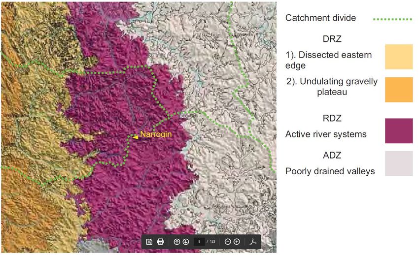
The Shire of Wandering Bushfire Management Plan 2021-2026 Page 15The western portion of the Shire is located on the Darling Range zone (DRZ), a broad uplifted plain of
and its eroded margins. This has distinct NW/SE patterns in ridges and valleys and has been cut by a
few large waterways from further east. Yellow brown gravely soils and sheet ironstone are common. 13
The Eastern portion of the Shire is in the Rejuvenated Drainage Zone (RDZ), which has an active
drainage system that joins the Avon, Blackwood and Murray (Hotham) rivers. The landscape is more
dissected, often with variable soils formed from dissected laterites and underlying igneous rock. 14
Wandering Town site
Figure 3: Landscape categories within the Shire of Wandering 15
The waterways in the Shire are often present challenges for access and crossing. Fires often spot across
the watercourses, where firefighters cannot easily cross and may have to travel some distance to be
able to get to the other side. This can often result in a significant delay in firefighting response allowing
fires to be able to grow quickly with limited suppression under the influence of significant slopes.
The western portion of the district is located on the Darling Plateau. Valleys in the western part of
the shire can
• impact rates of spread (ROS)
• can make prediction difficult as the valleys channel winds and create localised conditions (eg
fire moving against prevailing wind conditions)
• spotting ridge to ridge
13 Source: Landscape and soils of the Narrogin District, Dept of Agriculture and Food WA, 2010, Bulletin 4807
14 Source: Landscape and soils of the Narrogin District, Dept of Agriculture and Food WA, 2010, Bulletin 4807
15 Source: Landscape and soils of the Narrogin District, Dept of Agriculture and Food WA, 2010, Bulletin 4807
The Shire of Wandering Bushfire Management Plan 2021-2026 Page 16The eastern part of the shire is flatter with more agricultural land and fires here tend to be more
wind driven.
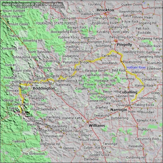
There is one major water way in the Shire these are shown in Figure 4. A major challenge for the Shire
is access and crossing waterways during fire events, water ways can pose a challenge to fire fighting
vehicles moving through areas of the landscape. This can restrict movement with limited crossovers
accessible. This is a significant consideration and limitation when responding to fires but also when
planning bushfire mitigation activities particularly in the context of risk management.
There are 13 bridges, throughout the Shire. These are located on major traffic routes, critical to tourism
and movement of agricultural produce. These bridges are also vital for the evacuation of communities
in emergencies and the movement of firefighting vehicles. The local and regional economy can be
adversely affected, and community safety impacted if bridges are damaged/destroyed by fire. The
BRM planning process has identified the bridges, particularly timber bridges, as a significant risk for
the Shire and they will be a priority for risk treatment.
Figure 4: Tributaries of Hotham River 16
16 Source: Bonzle Digital Atlas of Australia
The Shire of Wandering Bushfire Management Plan 2021-2026 Page 17KEY
Hotham River
Major Roads
Williams Regional Towns
Contine Local localities
The Wandering town site is marked on the above map (Figure 4).
3.2.2 Climate and Bushfire Season
Wandering has a Mediterranean climate with hot dry summers and cool, damp winters. In winter, it is
one of the coldest towns in Western Australia, not infrequently recording temperatures below 0 °C .17
The primary school's motto, "Cold Temperatures Warm Hearts", is testament to this. 18
The following weather statistics were obtained from the Bureau of Meteorology (BOM) Wandering
Station (Station ID 010917).
Bushfire threat is typically associated with very hot (above average temperatures), dry (less than 20%
humidity) and windy (above 12 – 15 Km per hour) conditions. Table 4 shows that the Shire of
Wandering can experience these thresholds throughout the year particularly during November to
March inclusive. The wettest months are May through September when about 70% of the annual
rainfall occurs. Weather is the primary influencer on fire activity19 and therefore needs to be a
significant consideration when planning both mitigation and response activities. The elevated risk to
the Shire of Wandering is usually December to February each year.
Table 4 – Climatic conditions within the Shire of Wandering 20
17 Source: Climate statistics for Wandering Comparison". Bureau of Meteorology. Retrieved 12 July 2014.
18 Source: Shire of Wandering. "Wandering Primary School". Retrieved 16 October 2006.
19 The Burning Issue: Climate Change and the Australian Bushfire Threat www.climatecouncil.org.au
20 Source: Bureau of Meteorology Wandering Station
The Shire of Wandering Bushfire Management Plan 2021-2026 Page 18Table 5: Average Maximum Temperature (Dec 1901 to Aug 2003) 21 Table 6: Average Minimum Temperature (Dec 1901 to Aug 2003) 22 21 Source: Bureau of Meteorology Wandering Station 22 Source: Bureau of Meteorology Wandering Station The Shire of Wandering Bushfire Management Plan 2021-2026 Page 19
Table 7: Average Rainfall (Dec 1998 to Aug 2020) Wandering Bom Station 23

The following diagrams look at prevailing winds in the context of the hotter months corresponding
with the peak of the fire season – December through February. These wind roses also indicate winds
predominantly from the South-East. The prevailing winds comes from the South-East in the mid-
afternoon. This is well known by the fire response personnel and subsequently fire management
strategies are developed with this in mind.

23   Source: Bureau of Meteorology Wandering Station

The Shire of Wandering Bushfire Management Plan 2021-2026                            Page 20
Figure 5: Wind rose reflecting predominant winds and wind speeds over the period Dec 1998 – Aug 2020 24

The following diagrams look at prevailing winds in the context of the hotter months corresponding
with the peak of the fire season – December through March. These wind roses also indicate winds
predominantly from the South-East. The prevailing winds comes from the South-East in the mid-
afternoon. This is well known by the fire response personnel and subsequently fire management
strategies are developed with this in mind.

24   Source: Bureau of Meteorology Wandering Station

The Shire of Wandering Bushfire Management Plan 2021-2026                                                           Page 21
December Average                                         January Average

                       February Average                                          March Average

Figure 6: Wind roses reflecting the annual predominant winds and wind speeds for the years 1998 to Nov 2021 taken from the Bureau
                                                of Meteorology Wandering Station. 25

25   Source: Bureau of Meteorology Wandering Station

The Shire of Wandering Bushfire Management Plan 2021-2026                                                        Page 22
The Forest Fire Danger Index (FFDI) is based on a combination of different weather conditions acknowledged to influence the risk of dangerous bushfire conditions in Australia, including temperature, rainfall, humidity and wind speed. In addition to the weather, bushfire events in Australia are also influenced by factors such as vegetation conditions, terrain and ignition sources. When a Fire Danger Index (FDI) reaches 50 the conditions are considered as severe; when conditions reach 75 the conditions are considered as extreme. The Forest Fire Danger Index and the Grass Fire Danger Index should be considered as indicative numbers only. This dataset provides observations-based information using a 67-year time period. It is intended for use in examining broad-scale features in fire weather conditions for regions throughout Australia. Where an FFDI of 50 and above is recorded between the months of November to February and is during the harvesting period, it can increase the ignition risk and making any fire severely difficult to suppress 26. The Grassland Fire Danger Index (GFDI) describes the rate of spread of a grass fire (and therefore the difficulty of putting it out.) The index was developed in Australia and has been adapted for the Great Plains. It is based on a combination of the “greenness” of the grass (percentage cured), and various meteorological parameters. The higher the index, the faster a grass fire will spread. The weather parameters (listed in decreasing order of importance) are wind, wind gusts, relative humidity and temperature, however, the biggest single factor is curing. Curing is a measure of the percentage of dead material in grass, as moisture content reduces as grass cures and dries out. The curing value of green grass is 0, and completely brown grass is 100. To spread rapidly, there has to be fuel, and completely cured grass is an excellent fuel. Conversely, green grass does not burn easily, regardless of wind or relative humidity. 27Harvest / vehicle movement bans are set using the GFDI. The level of bushfire hazard for human settlement, economic and cultural assets is determined using a quantified bushfire hazard assessment model. 28 The model is based on the methodology set out in AS3959-2009 Construction of buildings in bushfire prone areas that is used to undertake a Bushfire Attack Level (BAL) assessment. The hazard assessment is used to measure the severity of an asset’s potential exposure to ember attack, radiant heat and direct flame contact. Criteria applied when undertaking the bushfire hazard assessment is as follows: 29 Application of Fire Danger Index (FDI) 80. - The fire danger index reflects the chance of a fire starting, its rate of spread, its intensity and the difficulty of its suppression, according to various combinations of air temperature, relative humidity, wind speed and both the long- and short-term drought effects. Inputs to hazard assessment calculation are reflective of FDI 80 (Grass Fire Danger Index 110) conditions, as per AS3959-2009. The higher the rating, the less chance of controlling a fire until weather conditions improve. 26https://www.dfes.wa.gov.au/bushfire/prepare/ 27 www.weather.gov 28 Guidelines for Preparing a Bushfire Risk Management Plan (2015) 29 AS3959-2009 Construction of buildings in bushfire prone areas The Shire of Wandering Bushfire Management Plan 2021-2026 Page 23
The Shire of Wandering is located within the Upper Great Southern Fire Weather District. Given the
prevalence of agricultural holdings within the Shire of Wandering, the Grass Fire Danger Index is the
model applied to determine the FDI.
From the FDI, predictions can be made regarding a fire’s rate of spread, intensity and the potential for
various suppression tactics to succeed. The FDI is the basis for determining the Fire Danger Rating,
shown at figure 9, which is a scale developed to assist communities to better understand information
about fire danger. 30
3.2.3 Vegetation
The Shire of Wandering has three prominent types of vegetation throughout the shire.
The northern part of the Shire is the Marradong system. This consists of mainly Jarrah, Marri and
Wandoo forest. The trees in these forests have fine fibrous lose bark which easily ignites and can be
carried by the winds over long distances as embers, starting spot fires and impacting assets ahead of
the main fire front. Combined with the hilly topography on which it occurs these forest vegetation
types can create very intense and fast-moving fires.
DBCA under take prescribed burns in in these areas to help reduce the bushfire risks of this vegetation
type.
The eastern part is mainly the Dryandra system which consists mainly Wandoo and Sheok woodlands.
These woodlands tend to have a low open canopy with sparse shrubby understory. Fires in these areas
can be slow moving due to the sparseness of ground fuels. This area is predominantly broad acre
farmland (Wind driven fires) with remnant vegetation is pockets, much of the remnant Dryandra
woodlands is on private land. The shire manages this by its Local Government Wide Controls such as
fire break notices.
The Quindanning system is in the western part of the Shire and is similar to the Marradong system
with Marri, Wandoo, Yorkgum and Jam woodlands. Similar to the Dryandra system, most of this area
is managed by DBCA.

30   Source: Department of Fire and Emergency Services

The Shire of Wandering Bushfire Management Plan 2021-2026                                 Page 24
Wandering

                                      Figure 7: Vegetation categories within the Shire of Wandering 31

Three (3) aspects of vegetation within the Shire of Wandering that requires specific attention,
particularly in the context of bushfire mitigation treatment options moving forward, are:
       1. The ability for sheoak – e.g. Allocasuarina huegeliana to invade areas of other native
          vegetation, significantly changing the vegetation and fuel structure. This is a common concern
          across the region with areas being significantly affected.
       2. Managing annual weeds in remnant vegetation and the opportunity for these weeds to become
          established post mitigation works. Burning small remnants at the incorrect intensity, season
          or frequency can potentially result in higher fuel loads.
       3. Management of Waterways, particularly those in and around assets, are significant as they
          offer riparian vegetation corridors which can have a wick-like effect and are associated with
          fire runs with marked changes in fire behaviour, intensity and spread expected in this
          vegetation compared with other unvegetated land around them.
Whilst agricultural holdings (grassland) may appear to be a low bushfire risk, this vegetation presents
a significant bushfire hazard, especially during harvest season (November to January) when harvesting
activities have the potential to ignite a fire in fully cured crops. The impact of wind on open terrain
regardless of whether it is under crop, should not be underestimated.

31   Source: Landscape and soils of the Narrogin District, Dept of Agriculture and Food WA, 2010, Bulletin 4807

The Shire of Wandering Bushfire Management Plan 2021-2026                                                         Page 25
3.2.4 Threatened Species and Communities
Flora and fauna are significant assets, but also impact the treatment options available for reducing risk
to other assets. For example, the breeding cycle of some mammals, such as the Numbat, will restrict
the period in which prescribed burns can be undertaken due to the need to ensure nests are not
disturbed during the breeding season.
All risk treatments need to consider the requirements of the flora, fauna and communities located on
the site. Appropriate authorities must be consulted prior to any mitigation work commencing. The
Shire will take every opportunity to remind landowners/managers of their obligation to obtain
appropriate clearances and approvals, prior to commencing vegetation-based treatments. Response
strategies should be environmentally sensitive within the constraints of the incident.
A further consideration in relation to both bushfire prevention and response strategies is the potential
spread of weeds or diseases such as Phytopthora Cinnamomi (Dieback), which is easily spread through
soil movement from vehicles, animals, water and feet. Other fungal-borne diseases can also be spread
through these mechanisms. This risk must be considered in the context of planned prevention and
response strategies and the risk minimised wherever possible.
The Shire of Wandering is within the catchment of the Threatened Ecological Community – Eucalypt
Woodlands of the Western Australian Wheatbelt Ecological Community, listed under the Environment
Protection and Biodiversity Conservation Act 1999. The distribution of this community in the Shire is
show in figure 8.
Figure 8: Map reflecting the location of the Eucalyptus Threatened Ecological Community 32
32 Source: DFES Bushfire Risk Management System
The Shire of Wandering Bushfire Management Plan 2021-2026 Page 26The Approved Conservation Advice (including listing advice) for the Eucalypt Woodlands of the Western Australian Wheatbelt notes that altered fire regimes will have a significant impact on the threatened community. An altered fire regime includes any sustained changes from the long-term pattern of fires experienced at a site, this can include changes in frequency, seasonality and/or intensity. The Conservation Advice also notes that the response of the TEC to fire is site specific, that the TEC can benefit from an appropriate fire regime and that many responses to fire disturbance can be relatively temporary and/or minor. The impacts, both negative and positive, require careful consideration when undertaking prescribed burning in this TEC. A list of the Declared Rare Flora and Declared Rare Fauna applicable to the Shire of Narrogin is included at Appendix 3. 3.2.5 Bushfire Frequency and Causes of Ignition DFES records show that from 1/07/2007 – 30/06/2020, a total of 119 incidents were reported in the Shire of Wandering, reflecting on average 9 per year. Anecdotal evidence would suggest that this figure may not be accurate with the local information suggesting there have been other fires not reported through the formal systems. Recent education of local fire management personnel has seen an increase in credibility of fire reporting. Ongoing education is planned, through pre-fire season briefings, to ensure ongoing accuracy of reporting. The Shire of Wandering Bushfire Management Plan 2021-2026 Page 27
Table 8 – Reported landscape fires in the Shire of Wandering 2008 – 2019 33

Note: ‘Unreported’ - a known fire for which the ignition source was not provided to the incident reporting system. ‘Undetermined’ - the
cause of the fire cannot be confirmed by responders.

On review of the above ignition data it is indicated that “Weather Conditions – Lightning strikes” are
the most frequent cause of bushfire within the Shire. Local fire personnel make use of new technology
such as phone apps (Lightening Tracker) to monitor lightning strikes and forward deploy personnel to
conduct ‘on group’ checks. Bureau of Meteorology Weather Warnings are also widely circulated to fire
personnel. Agricultural related vehicle fires are the next most frequent, this challenge is largely
addressed by council by issuing Section 33 Notices and Harvest and Vehicle Movement Bans.

33   Source: Department of Fire and Emergency Services

The Shire of Wandering Bushfire Management Plan 2021-2026                                                            Page 28
3.2.6 Current Bushfire Risk Management Activities
Map of Bushfire Prone Areas
The intent of the WA Government’s Bushfire Prone Planning Policy is to implement effective risk based
land use planning and development to preserve life and reduce the impact of bushfire on property and
infrastructure. The State Planning Policy 3.7 – Planning for Bushfire Prone Areas ensures bushfire risk
is given due consideration in all future planning and development decisions. This policy does not apply
retrospectively, however the BRM Plan can help address this risk for existing development and
establish an effective treatment plan to manage the broader landscape and any unacceptable
community risks. The Shire of Wandering’s Bushfire Prone Area is shown in Figure 12.

                                               Figure 9: Bushfire Phrone mapping 34

Volunteer Fire Brigades
The Shire has 4 Bushfire Brigades. The Brigades are:
  • Codjatotine- Farmer Response
  • Hastings- Farmer Response
  • Wandering - 2.4 Appliance
  • Wandering Town – 2.4 Appliance

34   Source: Bushfire Risk Management System

The Shire of Wandering Bushfire Management Plan 2021-2026                                Page 29
The Shire of Wandering’s equipment is made available when required with specific actions to access
machinery during periods of high fire danger. Where the response to a fire exceeds the capacity of
local resources, additional support is provided from neighbouring shires and regions.
Burning Restrictions
The Bush Fires Act 1954, Sections 17 and 18, provides for the ‘declaration and gazettal’ of Prohibited
and Restricted Burning Times as well as the ability to adjust burning times to suit changing weather
conditions.
The Shire of Wandering’s Restricted and Prohibited Burning times are as follows, subject to possible
variation depending on each bushfire season with the Shire also imposing an annual ban during the
festive season:
• 1st October to 31st October: Restricted (permits required)
• 1st November to 21st February: Prohibited
• 22nd February to 19th April: Restricted (permits required)
The Shire maintains a Harvest Ban Hotline which enables residents to be informed, via SMS, when
Harvest Bans have been applied and removed.
Bush Fires Act 1954 Section 33 Bushfire Notices
To ensure landowners comply with the requirements under Section 33, the Shire undertakes the
following activities:
• Issuing the Fire Control Notice to landowners annually, including publication on the
Shire’s website and identifying additional recommended actions for landowners, over
and above the notice requirements;
• Publishing fire control information and reminders in the local newsletter, which
includes the Fire Control Order, Fire Control Officers, Burning Permits & Radio
Operators and Restricted & Prohibited Burning times;
• Ranger Services inspect townsite properties prior to the 31 October each year, usually
in September and any landowners that have not started hazard reduction activities
are issued with a reminder notice.
• Properties that aren’t compliant as at the 1 November each year are issued with a
notice & and infringement, with time to be deemed compliant;
• If landowners still don’t comply then work will be carried out by the Shire and costs
incurred recouped from the landowner (Section 33).
Community engagement activities
Whilst compliance with the Bush Fire Notice is generally good, when it comes to preparatory efforts
community engagement is more challenging, mainly due to time constraints and conflicting
The Shire of Wandering Bushfire Management Plan 2021-2026 Page 30priorities. The Shire advertises through media sources leading up to fire season and has volunteer
recruitment days throughout the year.
Other Current Local Government Wide Controls
Local Government Wide Controls are activities that reduce the overall bushfire risk within the Shire of
Wandering. These types of activities are not linked to specific assets and are applied across all or part
of the local government as part of normal business or due to legislative requirements. Some notable
controls currently in place in the Shire of Wandering are:
• Shire of Wandering Bush Fire Notice and (Bush Fires Act 1954)
• Shire Prohibited and Restricted burn times and issuing of permits. (Bush Fires Act 1954)
• Harvest and Vehicle Movement Bans
• Local Emergency Management Arrangements
• Total Fire Bans
Further information about the Local Government Wide Controls and how they will support the
treatment of bushfire risk can be found in section 6.1 Local Government Wide Controls.
4. Asset Identification and Risk Assessment
4.1. Planning Areas
The Shire of Wandering has a single planning area.
4.2. Asset Identification
Asset identification and risk assessment has been conducted at the local level using the methodology
described in the Guidelines using BRMS. Identified assets are categorised into the following categories
and subcategories provided in Table 9.
Table 9 – Asset Categories and Subcategories
Asset Category Asset Subcategories
Human Residential areas
Settlement Residential areas, including dwellings in rural areas and the rural-
urban interface.
Places of temporary occupation
Commercial and industrial areas, mining sites or camps and other
locations where people may work or gather.
Special risk and critical facilities
The Shire of Wandering Bushfire Management Plan 2021-2026 Page 31Asset Category Asset Subcategories
Locations and facilities where occupants may be especially vulnerable
to bushfire for one or more of the following reasons:
• Occupants may have limited knowledge about the impact of
bushfires;
• Occupants may have a reduced capacity to evaluate risk and
respond adequately to bushfire event;
• Occupants may be more vulnerable to stress and anxiety arising
from a bushfire event or the effects of smoke;
• There may be significant communication barriers with
occupants;
• Relocation and/or management of occupants may present
unique challenges or difficulties, such as transportation, or
providing alternative accommodation, healthcare or food
supplies; or
• Facilities that are critical to the community during a bushfire
emergency.
Economic Agricultural
• Areas under production, such as pasture, livestock, crops,
viticulture, horticulture and associated infrastructure.
Commercial and industrial
• Major industry, waste treatment plants, mines (economic
interest), mills, processing and manufacturing facilities and
cottage industry.
Critical infrastructure
• Power lines and substations, water pumping stations,
tanks/bores and pipelines, gas pipelines, telecommunications
infrastructure, railways, bridges, port facilities and waste
water treatments plants.
Tourist and recreational
• Tourist attractions, day-use areas and recreational sites that
generate significant tourism and/or employment within the
local area. These assets are different to tourist
accommodation described as a Human Settlement Asset (see
above).
Commercial forests and plantations
• Plantations and production native forests.
The Shire of Wandering Bushfire Management Plan 2021-2026 Page 32Asset Category Asset Subcategories
Drinking water catchments
• Land and infrastructure associated with drinking water
catchments.
Environmental Protected
Flora, fauna and ecological communities that are listed as a:
• Critically Endangered, Endangered or Vulnerable species under
the Environmental Protection and Biodiversity Conservation Act
1999 (Cth) (EPBC Act 1999) (including associated critical
habitat);
• Critically Endangered, Endangered or Vulnerable species under
the Biodiversity Conservation Act 2016;
• Critically Endangered, Endangered or Vulnerable ecological
community under the EPBC Act 1999 (Cth);
• Critically Endangered, Endangered or Vulnerable Threatened
Ecological Community (TEC) endorsed by the Minister for
Environment (WA);
• Fauna protected under international conventions; and
• Ramsar wetlands of international importance.
Priority
Flora, fauna and ecological communities that are a:
• Priority species listed on the Priority Flora or Priority Fauna Lists
held by DBCA (Priority 1-5).
• Priority Ecological Community (PEC) (Priority 1-5); and
• Wetlands of national or state importance.
Locally important
• Species, populations, ecological communities or habitats that
the local community or independent scientific experts consider
important for the area and for which there is some scientific
evidence that protection would be beneficial.
• Wetlands of local importance.
• Sites being used for scientific research.
Cultural Aboriginal heritage
• Places of indigenous significance identified by the DPLH or the
The Shire of Wandering Bushfire Management Plan 2021-2026 Page 33Asset Category Asset Subcategories
local community.
European heritage
• Non-Indigenous heritage assets afforded legislative protection
through identification by the National Trust, State Heritage List
or Local Planning Scheme Heritage List.
Local heritage
• Assets identified in a Municipal Heritage Inventory or by the
local community as being significant to local heritage.
Other
• Other assets of cultural value to the local community, for
example community halls, churches, clubs and recreation
facilities.
4.3. Assessment of Bushfire Risk
Risk assessments have been undertaken for each asset or group of assets identified using the
methodology described in the Guidelines.
The Shire has elected not to append a copy of Asset Risk Register to this document, as the information
contained is subject to change over time as treatments are undertaken and risks re-assessed. Current
asset, risk assessment and treatment information will be maintained in BRMS, with relevant reports
provided to key stakeholders on an ongoing basis.
The percentage of assets within the local government in each asset category at the time of BRM Plan
endorsement is shown in Table 10.
Table 10 – Asset Category Proportions
Asset category Proportion of identified assets
Human Settlement 80.5%
Economic 14.5%
Environmental 0.7 %
Cultural 4.3%
The Shire of Wandering Bushfire Management Plan 2021-2026 Page 344.3.1 Consequence Assessment
Consequence is described as the outcome or impact of a bushfire event. The approach used to
determine the consequence rating is different for each asset category: Human Settlement;
Economic; Environmental; and Cultural.
The methodology used to determine the consequence rating for each asset category is
based on the following:
• Consequence Rating – Human Settlement, Economic and Cultural Assets
The outcome or impact of a bushfire event on the asset, or a group of assets,
measured by the hazard posed by the classified vegetation and the
vulnerability of the asset.
• Consequence Rating – Environmental Assets
The outcome or impact of a bushfire event on the asset, or a group of assets,
measured by the vulnerability of the asset and the potential impact of a
bushfire or fire regime.
4.3.2 Likelihood Assessment
Likelihood is described as the potential of a bushfire igniting, spreading and impacting an asset. The
approach used to determine the likelihood rating is the same for each asset category: Human
Settlement; Economic; Environmental; and Cultural.
4.3.3 Assessment of Environmental Assets
Using available biological information and fire history data, environmental assets with a known
minimum fire threshold were assessed to determine if they were at risk from bushfire, within the five-
year life of the BRM Plan. Environmental assets that would not be adversely impacted by bushfire
within the five-year period have not been included and assessed in the BRM Plan. The negative impact
of a fire on these assets (within the period of this BRM Plan) was determined to be minimal and may
even be of benefit to the asset and surrounding habitat.
4.3.4 Local Government Asset Risk Summary
A risk profile for the local government is provided in Table 11. This table shows the proportion of assets
at risk from bushfire in each risk category at the time the BRM Plan was endorsed.
The Shire of Wandering Bushfire Management Plan 2021-2026 Page 35You can also read