Downtown Toms River Waterfront Redevelopment Plan
←
→
Page content transcription
If your browser does not render page correctly, please read the page content below
R E V I S E D   D R A F T

Downtown Toms River Waterfront Redevelopment Plan
                                            Township of Toms River, NJ

                                                            Prepared for
                            The Toms River Business Improvement District

                                                                           by
                                   Phillips Preiss Shapiro Associates, Inc.
                                           Planning & Real Estate Consultants

                                                            September, 2009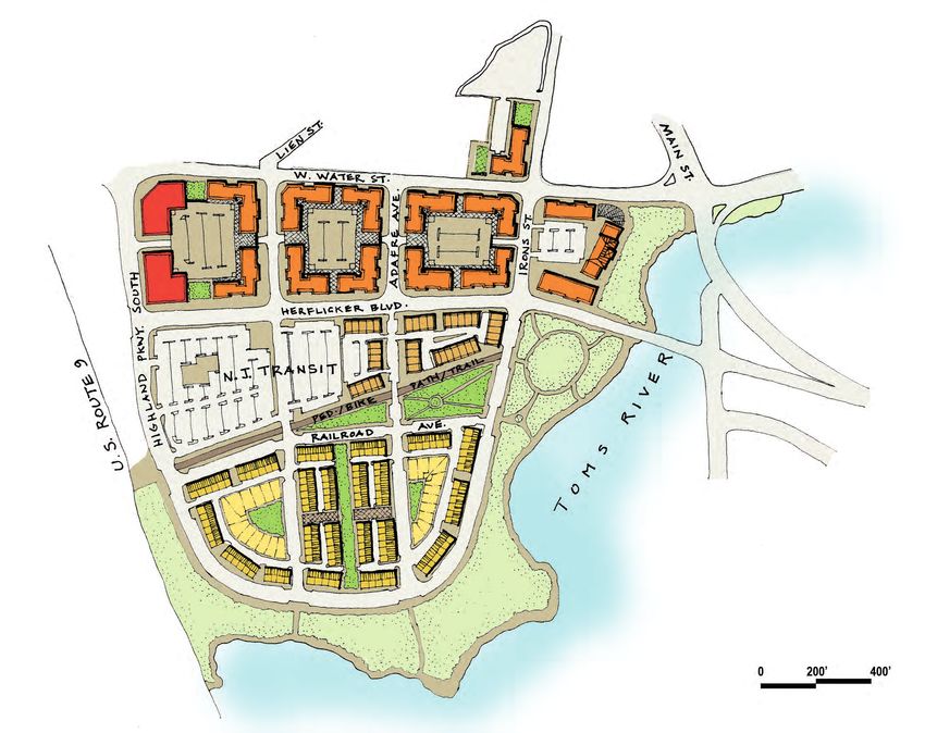
this page is left intentionally blank
Downtown Toms River Waterfront Redevelopment Plan

TABLE OF CONTENTS

1    Introduction ......................................................................................................................... 1
    1.1 Statutory Basis for the Redevelopment Plan ....................................................................................1
    1.2 Purpose...................................................................................................................................................1
    1.3 Note on Plan Terminology..................................................................................................................2
    1.4 Redevelopment Plan Overview ..........................................................................................................2
    1.5 Description of Redevelopment Area Boundaries............................................................................3
    1.6 Existing Land Uses and Context ........................................................................................................3

2    Vision, Goals and Context ...................................................................................................8
    2.1 Vision......................................................................................................................................................8
    2.2 Redevelopment Plan Goals and Objectives......................................................................................8
    2.3 Conceptual Design Plan.......................................................................................................................9
    2.4 Relationship to Local Objectives........................................................................................................9
    2.5 Pedestrian/Vehicular Connections ..................................................................................................14
    2.6 Relationship to Intent and Purpose of the Zoning Code.............................................................15

3    Land Use and Development Plan...................................................................................... 18
    3.1 Relocation of New Jersey Transit Park and Ride Lot ...................................................................18
    3.2 Street Network ....................................................................................................................................18
    3.3 Open Space ..........................................................................................................................................20
    3.4 Land Uses.............................................................................................................................................21
    3.5 Yield & Bulk ........................................................................................................................................23
    3.6 Parking Standards ...............................................................................................................................25
    3.7 Design Standards ................................................................................................................................28

4    Redevelopment Actions ..................................................................................................... 32
    4.1 Outline of Proposed Actions ............................................................................................................32
    4.2 Properties to be Acquired..................................................................................................................32
    4.3 Other Actions......................................................................................................................................32
    4.4 Relocation ............................................................................................................................................32

5    Relationship to Development Regulations and Other Plans ............................................ 33
    5.1 Relationship to the Toms River Master Plan..................................................................................33
    5.2 Relationship to the Township of Toms River Zoning Ordinance..............................................34
    5.3 Relationship to Master Plans of Adjacent Municipalities .............................................................34
    5.4 Relationship to the Ocean County Master Plan.............................................................................34
    5.5 Relationship to the State Development and Redevelopment Plan .............................................35

REVISED DRAFT - September 24, 2009                                                                                                                                  i
Downtown Toms River Waterfront Redevelopment Plan

6    General Provisions ............................................................................................................. 36
    6.1 Definitions ...........................................................................................................................................36
    6.2 Easements ............................................................................................................................................36
    6.3 Site Plan and Subdivision Review.....................................................................................................36
    6.4 Approvals by Other Agencies...........................................................................................................36
    6.5 Adverse Influences .............................................................................................................................36
    6.6 Non-Discrimination Provisions .......................................................................................................37
    6.7 Duration of the Plan...........................................................................................................................37
    6.8 Deviation Requests.............................................................................................................................37
    6.9 Escrows ................................................................................................................................................37

7     Other Provisions ................................................................................................................ 38

8     Procedure for Amending the Approved Plan .................................................................... 39

TABLE OF FIGURES

Figure 1: Project Location .................................................................................................................................4
Figure 2: Redevelopment Area Boundaries ....................................................................................................5
Figure 3: Aerial Context.....................................................................................................................................6
Figure 4: Existing Land Uses ............................................................................................................................7
Figure 5: Conceptual Design Plan..................................................................................................................10
Figure 6: Design Vision: Northern Blocks....................................................................................................11
Figure 7: Design Vision: Central Blocks .......................................................................................................12
Figure 8: Design Vision: Southern Blocks ....................................................................................................13
Figure 9: Zoning Context ................................................................................................................................16
Figure 10: Public Space Regulating Plan .......................................................................................................30
Figure 11: Building Regulating Plan...............................................................................................................31

REVISED DRAFT - September 24, 2009                                                                                                                              ii
Downtown Toms River Waterfront Redevelopment Plan 1 Introduction 1.1 STATUTORY BASIS FOR THE REDEVELOPMENT PLAN This Redevelopment Plan has been prepared for the properties known collectively as the Downtown Toms River Waterfront Area within the Township of Toms River, Ocean County, New Jersey. In this report, the Downtown Toms River Waterfront Area will generally be referred to as the “rede- velopment area.” It incorporates all lots on six tax blocks (566.01, 566.02, 566.03, 567, 569, and 570) and portions of blocks 566.04 and 658 within Toms River Township. The Township Council of the Township of Toms River directed the Township’s Planning Board to study the area in order to determine whether it was in need of redevelopment in accordance with the criteria specified in state law at N.J.S.A. 40A:12A-5. The consulting planners, Phillips Preiss Shapiro Associates, Inc., then conducted a redevelopment area investigation, which was completed in June 2008. A public hearing on the investigation was the held by the Planning Board, which subsequently determined, based on the results of the investigation that the study area qualified as an Area in Need of Redevelopment. Phillips Preiss Shapiro Associates was then directed to prepare a Redevelopment Plan for the area in question. For this Plan to be put into effect, it must be referred to the Planning Board for up to 45 days. Following receipt of the Planning Board recommendation concerning the Redevelopment Plan, the Plan may be adopted by the Township Council by ordinance as stipulated at N.J.S.A. 40A:12A-7. 1.2 PURPOSE The Plan describes the vision and sets standards for the area located at the southern end of Toms River Township and at the western end of the navigable portion of the Toms River. The Plan de- scribes existing conditions; proposes new streets, parks, and other public spaces; and provides guide- lines for high-quality development. Figure 1, Project Location, shows the general location of the project within the greater context of the Township and surrounding communities. The design and land use concepts of this Redevelopment Plan have their basis in the 2005 Downtown Toms River Vision Plan and Master Plan. Key recommendations in the Vision Plan and Master Plan grew out of interactions with local stakeholders representing the public, local and county Government, and the business community. Significant outreach included over 30 interviews, a public workshop, and a collaborative process with the Toms River Business Improvement District (TRBID). The vi- sion identified by the community for Downtown Toms River included recommendations for bring- ing the “Downtown Core” along Main and Washington Streets, across East and West Water Streets, and to the riverfront. The Redevelopment Plan will redefine the area primarily south of West Water Street. The Plan extends the walkable pattern found in the current downtown area to the waterfront. Existing structures in the redevelopment area will be replaced with a mix of uses including residential, retail, office, river- front open space, parking, and community facilities. The introduction of housing to the redevelop- ment area will promote a strong residential base in this portion of Toms River, providing a stronger market to support existing and proposed retail in the downtown area. New retail and recreational REVISED DRAFT - September 24, 2009 1
Downtown Toms River Waterfront Redevelopment Plan
amenities will complement the existing downtown located north of West Water Street. Development
will be transit-oriented in nature to take advantage of the bus service at the busy New Jersey Transit
park & ride located in the redevelopment area. In addition, the increased number of residents, shop-
pers, and other visitors will significantly enliven the downtown area.
1.3 NOTE ON PLAN TERMINOLOGY
Throughout this Redevelopment Area, a conscious distinction is made in the regulations between
“shall” and “should”.
“Shall” or “must” means that a developer is required to comply with the specific regulation,
without deviation.
“Should” means that a developer is encouraged to comply but is not required to do so. If the
exact recommendation cannot be met, the Planning Board will entertain any modification
that meets the underlying spirit and intent of the regulation and/or the Redevelopment Plan
generally.
1.4 REDEVELOPMENT PLAN OVERVIEW
Many redevelopment plans are intended for a large area to be rebuilt by a master developer, with all
property within the project area subject to eminent domain for acquisition on behalf of the desig-
nated redeveloper. The intent of this Plan is different in two respects. First, it contemplates that the
redevelopment will be implemented over time by more than one redeveloper. This gives the Plan
flexibility to respond to changing market conditions, and to accommodate a diversity of approaches
with regards to design and layout. Second, the Plan is intended to provide an avenue for existing
property owners within the redevelopment area to profit directly from the redevelopment of their
properties, either through their taking the lead with regards to development, or working with a de-
velopment partner.
The Redevelopment Plan at its heart consists of a new required street network defining blocks for de-
velopment, and a set of land use and design controls for these blocks. The purpose of the required
street network is to provide for phased redevelopment and adequate internal circulation. The land
uses contemplated for the Plan are intended to complement four unique factors of the area:
its proximity to downtown Toms River and the County Seat;
its waterfront location;
its proximity to a full interchange with the Garden State Parkway;
and the presence of the New Jersey Transit bus park and ride, which hosts about 2,000 rid-
ers per day, as much as many commuter rail stations.
The land uses are therefore intended to accomplish the following:
Ensure at least a rough doubling of the amount of retail square footage in downtown Toms
River (currently about 50,000 square feet1), and more if possible, to create a retail destination
in the downtown.
Create a transit village incorporating a variety of housing types, with an emphasis on housing
that can benefit from the waterfront location and views.
1 Source: Downtown Toms River Vision Plan and Master Plan, May 2005, page 2.8,
REVISED DRAFT - September 24, 2009 2Downtown Toms River Waterfront Redevelopment Plan
Bring a critical mass of activity and vitality to the area while also ensuring that new develop-
ment will not overwhelm the downtown.
Provide 660 residential units, of which at least 20 percent (132 units) shallbe affordable units,
in order to comply with the Township’s Housing Element and Fair Share Plan.
Provide additional office space to accommodate demand from attorneys and other professionals
wanting space close to the County offices or in a downtown location.
1.5 DESCRIPTION OF REDEVELOPMENT AREA BOUNDARIES
The area declared in need of redevelopment encompasses developed and undeveloped lands located
along the north shore of the Toms River and primarily south of West Water Street. The study area
includes all of tax blocks 566.01, 566.02, 566.03, 567, 569, and 570; and parts of tax blocks 566.04
and 658. The total area of the site is ±63 acres. The specific redevelopment area boundaries are
shown on Figure 2, Redevelopment Area Boundary. The area is generally bounded by West Water
Street on the north, the Garden State Parkway on the west, and the Toms River on the south and
east, with some parcels located north of West Water Street at Irons Street.
At 16.9 acres, Lot 1.03 in Block 570 is the largest parcel in the redevelopment area. The southern
frontage of this irregularly-shaped parcel fronts the Toms River. The municipal boundary line sepa-
rating Toms River Township from Berkeley Township and South Toms River Township is demar-
cated between the banks of the Toms River. At the northern end of the redevelopment area, the
largest parcel fronting West Water Street is Lot 4 in Block 566.01 at 5.6 acres. Lot 4 maintains ap-
proximately 500 feet of frontage on West Water Street and 480 feet of frontage on Herflicker Bou-
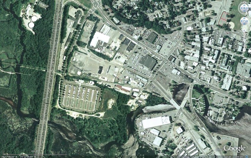
levard to the south. Refer to Figure 3, Aerial Context for an aerial view of the redevelopment area
and the surrounding areas.
1.6 EXISTING LAND USES AND CONTEXT
The study area as it exists today (with the exception of certain frontage on West Water Street) con-
tinues to be a largely industrial area. Most of the area is developed with industrial uses, with a few
institutional/governmental uses, commercial uses and public utilities scattered throughout. Figure
4, Existing Land Uses, shows the land uses of the redevelopment area and the surrounding prop-
erties.
REVISED DRAFT - September 24, 2009 3Figure 1: Project Location
Study Area
Redevelopment Area
Downtown Toms River Waterfront Redevelopment Plan
Phillips Preiss Shapiro Associates, Inc. 2009 Approx. Miles
0 1 2Figure 2: Redevelopment Area Boundaries
Y
W A
R K
P A
E
A T
S T
E N
R D
G A
Redevelopment Area
Downtown Toms River Waterfront Redevelopment Plan
Approx. Feet
Phillips Preiss Shapiro Associates, Inc. 2009 0 200 400Figure 3: Aerial Context
h t
We
st
Sou
Wa
ter
ark
Str
P
eet
d
e
nu
hlan
ve
Hig
fr eA
A da
Parrkway
Her
flic
et
ate
ker Bo
t
ule
Stre
e
var
d
n
S tre
Mai
Garden St
ns
Iro
Downtown Toms River Waterfront Redevelopment Plan
Phillips Preiss Shapiro Associates, Inc. 2009Figure 4: Existing Land Uses
ay
Parkw
Redevelopment Area
State
Retail/Service Commercial
n
Eating/Drinking Establishment
Business/Offices
Garde
Institutional/Governmental
Utility
Industrial/Auto-related
Arts/Culture
Hotel
Marina
Single-Family Residential
Two-Family Residential
Multi-Family Residential
Mixed Commercial/Office
Mixed Commercial/Restaurant
Mixed Restaurant/Arts
Mixed Restaurant/Commercial/Office
Mixed Restaurant/Office
Mixed Industrial/Office
Mixed Office/Multi-family housing
Park
Cemetery
Park
Vacant
Downtown Toms River Waterfront Redevelopment Plan Miles .5
Phillips Preiss Shapiro Associates, Inc. 2009Downtown Toms River Waterfront Redevelopment Plan
2 Vision, Goals and Context
2.1 VISION
The Downtown Toms River Waterfront Redevelopment Plan envisions a mixed-use neighborhood with
active retail, office uses, residential options, transit and most importantly a revived and accessible
riverfront and downtown. The Redevelopment Plan aims to revitalize a largely underutilized area into an
active downtown and mixed-use community for the Township. The Plan also hopes to increase rid-
ership at the existing New Jersey Transit bus station and to complement and enhance the existing
businesses and character of the downtown. The Redevelopment Plan uses smart-growth planning prin-
ciples and the regulation of building design and form to create an attractive and sustainable neigh-
borhood. The Plan provides for a variety of housing options (single-family, townhouse, live-work,
apartment units), high quality of retail, a safe and appealing pedestrian environment, open spaces
including riverfront walkways and parks and an effective street network and circulation pattern. The
Plan sets forth standards for required improvements, allowable land uses, development densities,
street network and design, building massing and form and other design standards. In general, the
Plan focuses on creating a meaningful riverfront with an attractive community and on bringing the
downtown to the river.
2.2 REDEVELOPMENT PLAN GOALS AND OBJECTIVES
The specific goals and objectives of the Redevelopment Plan are as follows:
To provide a framework for the phased redevelopment of the West Water Street area that al-
lows multiple developers and existing property owners to implement the Plan over time,
while still resulting in a cohesive development.
To stimulate an appropriate level of development that provides public benefits to the Town-
ship and does not overwhelm the Township’s infrastructure.
To reduce the negative impacts of existing unproductive lands.
To provide for continuous public access to the waterfront through pedestrian connections.
To provide for an increase in the economic base of the redevelopment area and the entire
Township by redeveloping underutilized and non-productive properties.
To provide for the development of passive recreation facilities along the waterfront to serve
the future residents of the redevelopment area and the Township.
To facilitate the environmental cleanup of the redevelopment area in an expeditious manner.
To significantly expand the amount of mixed-use retail/office/residential development in
Downtown Toms River.
To protect the waterfront and the Toms River from the negative impacts of improper devel-
opment.
REVISED DRAFT - September 24, 2009 8Downtown Toms River Waterfront Redevelopment Plan
To utilize design guidelines and regulations to foster relationships between buildings, streets,
parking areas, walkways and landscaped areas, both within the redevelopment area and in the
context of the surrounding area.
To encourage the revitalization of the redevelopment area in a manner that is compatible
with the character of adjacent properties and land uses.
2.3 CONCEPTUAL DESIGN PLAN
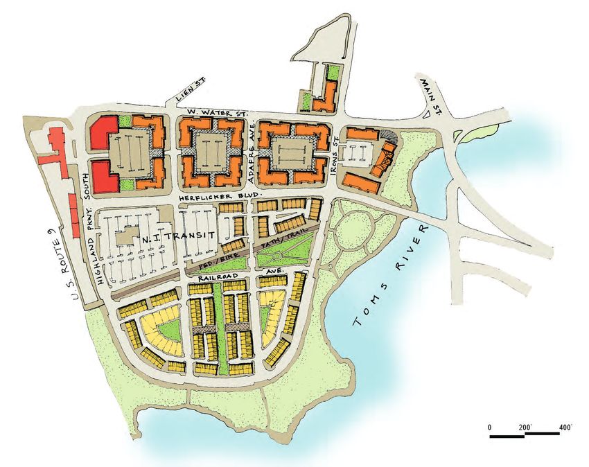
An illustrative conceptual plan showing how the requirements of this Redevelopment Plan could be met
is provided in Figure 5, Conceptual Design Plan. Further explanation of this design concept is
shown in Figure 6, 7 and 8, for the northern, central, and southern blocks, respectively. Redevel-
opers are not required to adhere to this conceptual plan and are encouraged to have their design
professionals modify the conceptual plan or to devise their own project plans that fulfill the re-
quirements outlined above. In particular, it is recognized that more detailed evaluation of the envi-
ronmental conditions on the site may be required to determine a feasible and beneficial design.
2.4 RELATIONSHIP TO LOCAL OBJECTIVES
The local objectives for the Redevelopment Area are expressed in the 2005 Downtown Toms River Vi-
sion Plan and Master Plan. The community’s vision for this area is clearly stated in this document and
encompasses the following goals with respect to the Redevelopment Area:
Link the downtown to a newly created riverfront area, to feature boating, walking and cy-
cling; and an opportunity to study and interpret the river environment.
Double amount of retail space in Downtown Toms River, to serve as the regional down-
town for all of Ocean County.
Position Toms River as the cultural hub of the region, to encompass history and heritage,
and the visual and performing arts.
To fulfill this comprehensive vision, the Redevelopment Plan includes detailed planning and design
standards for mixed use development, and requires that each individual stage of construction be
properly related to every other stage of the redevelopment project. In creating the regulations and
guidelines for the Redevelopment Plan, the following Master Plan objectives served as the foundation:
Land Use
Develop a waterfront greenway running from Huddy Park to the Garden State Parkway, and
linked to parks in South Toms River.
Take advantage of the combination bus terminal, riverfront and downtown amenities, and
assemblage, to pursue Transit-Oriented Development (TOD) involving attached or multiple
dwellings oriented to public streets and the riverfront park.
Provide a location for kayaking, rowboat and canoe launch/takeout/concession on the
Toms River west of the Main Street Bridge.
REVISED DRAFT - September 24, 2009 9Figure 5: Conceptual Design Plan Downtown Toms River Waterfront Redevelopment Plan Phillips Preiss Shapiro Associates, Inc. 2009
West Water Street serves as a
Figure 6: Design Vision: Northern Blocks                                                   Stand-alone retail                           mixed-use / retail street,
                                                                                                                                        an extension of downtown

                                                                                                                                                        Public parking lot or deck
                                                                                                                                                        to serve downtown businesses

West of Highland Parkway
  South, reuse of DMUA
        buildings for retail,
               restaurants
                                                                                                                                                               4-story building with ground-floor
                                                                                                                                                               retail along W. Water;
                                                                                                                                                               ground-level offices along Irons;
                                                                                                                                                               offices overhead

                        Along West Water & Herflicker:
                           4 and 5-story buildings with
                                    ground-floor retail,
                              housing on upper stories

                                                   Along north-south side streets:
                                                4-story buildings with ground-floor
                                                     retail, offices on upper stories

                                                                      Center-block two-level parking
                                                                 decks are architecturally screened
                                                                 along north-south side streets, and               Existing buildings
                                                                    hidden behind active uses along             removed to enhance
                                                                            West Water & Herflicker                 connection from
                                                                                                                        downtown to
                                                                                                                     riverfront parks

Downtown Toms River Waterfront Redevelopment Plan
Phillips Preiss Shapiro Associates, Inc. 2009
Figure 7: Design Vision: Central Blocks
Soil remediation pump-and-treat system
enclosed in structure
NJ Transit park-and-ride lot; could also
include structured parking to be shared with
other uses (pending NJ Transit approval)
Stacked flats with rear alley-loaded garages
Riverfront public park
West of Highland Parkway for community-wide use
South, reuse of DMUA
buildings for retail,
restaurants
Bikeway / pathway connects area to
potential future trailway to west
and to riverfront parks at east
Stacked flats face linear
bikeway & parks
Public park, primarily
for local resident use
Downtown Toms River Waterfront Redevelopment Plan
Phillips Preiss Shapiro Associates, Inc. 2009Figure 8: Design Vision: Southern Blocks
“Green court” single-family detached homes face public street and
central common green space aligning with mid-block pedestrian
connections; garages face rear alley shared with townhouse units
Townhouses face public streets. Garages
are at rear,accessed by alleys.
Townhouses face residential linear green, improving
connections through blocks to riverfront areas
Mid-block pedestrian pathways help break up large blocks,
improve street network’s permeability for walking
Townhouses face riverfront
park and public streets
Gently curving street borders the riverfront park system,
providing continuous public access and visibilty / safety
Lower-elevation area continues
the riverfront park system
Downtown Toms River Waterfront Redevelopment Plan
Phillips Preiss Shapiro Associates, Inc. 2009Downtown Toms River Waterfront Redevelopment Plan
As part of the expanded park area, create an opportunity for a new band shell.
Prioritize waterfront sites for housing.
Provide for mixed-use buildings with residential or offices over retail.
Consider moving the New Jersey Transit commuter bus terminal parking from its current
location to the New Jersey Natural Gas and JCP&L site.
2.5 PEDESTRIAN/VEHICULAR CONNECTIONS
Place a priority on pedestrian improvements across Water Street and at the intersection of
Main Street and Water Street.
Create a Herflicker Boulevard/Highland Parkway bypass, to diminish congestion from the
existing downtown and Main Street.
Parking
Increase on-street parking, and manage the supply with shopper convenience as the goal.
Where appropriate, work with the Parking Authority to consolidate public parking into two-
or three-story structures lined with retail or combined with office development.
Provide incentives for structured parking, and promote shared parking.
Provide one-for-one replacement of all New Jersey Transit parking as part of any plans for
moving the bus park and ride from its present location.
Implementation Tools
Adopt standards within the West Water Street area that emphasize a neo-traditional ap-
proach, so as to blend with the existing downtown and encourage a walking environment.
Adopt design guidelines and/or a local history district.
This Redevelopment Plan seeks to refine and fulfill the objectives and concepts set forth in the 2006
Toms River Township Master Plan and the 2005 Downtown Toms River Vision Plan and Master
Plan. The specific goals and objectives addressed by this Redevelopment Plan were generated through a
community-driven process guided by a Steering Committee which issued its final recommendations
in October 2004. As set forth above, Toms River Township has established definite local objectives
pertaining to appropriate land use, circulation patterns, and recreational and community facilities.
This Plan addresses and serves each of these objectives, as set forth herein.
REVISED DRAFT - September 24, 2009 14Downtown Toms River Waterfront Redevelopment Plan 2.6 RELATIONSHIP TO INTENT AND PURPOSE OF THE ZONING CODE Under the current zoning map of the Township, the Redevelopment Area lies entirely within the Village Business (VB) zoning district. Zoning boundaries of the subject properties and the surround- ing areas is shown in Figure 9, Zoning Context. The subject properties are surrounded by several different districts as listed below: VO – Village Office Zone HB – Highway Business Zone DS – Downtown Service Zone R-50 – Residential Zone VS – Village Seaport Zone Primary permitted uses generally include retail goods and services, personal services, offices, restau- rants, municipal buildings, funeral homes, child care centers, churches, theaters, adult-care centers, schools and dwelling units. Conditional uses include hotels and motels, bed and breakfast, home professional offices and public utilities. Bulk standards for the VB Village Business Zone require a minimum of 5,000 square feet of lot area, minimum lot width of 50 feet and minimum lot depth of 100 feet. The zone has a required mini- mum front yard setback of 5 feet and maximum 10 feet, a minimum rear yard setback of 20 feet and no side yard setback is required. The maximum building height is 50 feet and four stories and the maximum lot coverage is 80% for principal buildings and accessory buildings. There is no minimum for unoccupied open space and minimum lot frontage is 50 feet for an interior lot and 75 feet on both streets for a corner lot. A detailed list of permitted uses and area, yard and building requirements in shown in Table 1, VB Village Business Zone. Since the vision for the Redevelopment Area calls for a variety of building types (townhouses, sin- gle-family, live-work units, mixed-use apartment buildings) and land uses (residential, commercial, transit parking, open space), the current zoning regulations are no longer relevant for the area. As such, the existing zoning is not consistent with the use and bulk regulations contained within this Plan. REVISED DRAFT - September 24, 2009 15
Figure 9: Zoning Context

                                                             HB   DS   SC-AH2             VO        R-50
                                                                                 MF-6

                                                                                   R-50                    VO

                                                                            DS

                                                            ay
                                                       Parkw
                                                     State
                                                                                               VB

                                                      n
                                                VO

                                                 Garde
                                                                       VB                                               VS
         Study Area

Downtown Toms River Waterfront Redevelopment Plan                                                               Miles        .5
Phillips Preiss Shapiro Associates, Inc. 2009
Table 1: VB Village Business Zone: Summary of Uses, Area, Yard & Building Requirements
Principal Permitted Uses*
1. The retail sale of goods, which may include the following: 3. Business and professional offices and banks and financial institutions.
Grocery stores. 4. Restaurants, lunchrooms, bars and other eating and drinking establishments, but
Drugstores. not including drive-in restaurants.
Dry goods stores. 5. Publication of newspapers and periodicals.
Meat and poultry stores. 6. Federal, state, county and municipal buildings and grounds, but excluding schools.
Baked goods stores. 7. Essential services.
Packaged liquor stores. 8. Funeral homes, including one dwelling unit.
Flower shops. 9. Churches and places of worship.
Confectionary stores. 10. Child-care centers.
Household supplies stores. 11. Theaters.
Stationery supplies, tobacco and periodical stores. 12. Offices and facilities for businesses in the communications and information
Haberdashery, dress goods and notions. industry in that portion of the zone south of West Water Street.
Hardware, plumbing supplies and electrical supplies. 13. Adult-care centers.
Boat supplies. 14. Schools for vocational instruction.
Shops of artisans and craftsmen. 15. Dwelling units on the second floor and higher only, subject to the provisions of
Furniture and appliance stores. § 348-8.39.
Gift shops.
2. Personal service establishments, which may include the following but shall not include tattoo parlors and body piercing:
Barbershops and beauty shops. Appliance repair shops.
Tailoring and dressmaking shops. Radio and television repair shops.
Dry-cleaning and laundry collection shops, but not including self-service laundries. Art, music, dancing, gymnastics and other similar instructional schools.
Shoe repair shops.
Permitted Accessory Uses Required Accessory Uses
Fences subject to the provisions of § 348-8.13. Off-street parking subject to the provisions of § 348-8.20
Signs subject to the provisions of § 348-8.26. Off-street loading subject to the provisions of § 348-8.19
Other customary accessory uses and buildings which are clearly incidental to the principal use and building.
Outdoor cafes, subject to the provisions of § 348-8.41.
Permitted Conditional Uses
Public utilities (§ 348-9.6).
Hotels and motels (§ 348-9.15) only in that portion of the Village Business Zone located south of West Water Street.
Bed-and-breakfast establishments subject to the provisions of § 348-9.30.
Home professional offices subject to the provisions of § 348-9.11.
Bulk Standards for Principal Use
· Min. lot area: 5,000 sq.ft. · Min. rear yard: 20 feet
· Min. lot width: 50 ft. · Min. gross floor area: 1,200 sq. ft.
· Min. lot frontage: 50 ft. (interior lot), 75 feet (corner lot) · Max. lot coverage: 80%
· Min. lot depth: 100 feet · Min. unoccupied open space: None
· Min. front setback 5 to 10 feet · Max. building height 50 feet or 4 "usable stories"
· Min. side yard: none*
Downtown Toms River Waterfront Redevelopment Plan
Phillips Preiss Shapiro Associates, Inc. 2009 Source: Township of Toms River Zoning Ordinance, www.generalcode.comDowntown Toms River Waterfront Redevelopment Plan
3 Land Use and Development Plan
The following chapter sets forth the regulating plan for the redevelopment area . It includes both de-
tailed standards for development as well as descriptive narrative regarding the desired outcomes of
the redevelopment process. Different land uses are permitted in different portions of the project
area, as discussed below. This chapter also includes a detailed concept plan showing how the even-
tual redevelopment of the Plan area, consistent with the standards and recommendations set forth
herein, might be accomplished. This concept plan should serve as a guide to redevelopers, but is
only one example of how the Plan might be achieved.
3.1 RELOCATION OF NEW JERSEY TRANSIT PARK AND RIDE LOT
An active New Jersey Transit Park and Ride Lot is located in the southwestern portion of the Plan
Area, south of the existing unused railroad right-of-way (now an easement owned by the Township).
This Park & Ride lot is very well used for weekday commuters. Directly to its north is a cluster of
several industrial parcels owned by New Jersey Natural Gas and Jersey Central Power and Light
(JCP&L), in a site that is undergoing a 20-year pump-and-treat remediation.
In order to make available a sufficient critical mass of land for redevelopment, create a new neigh-
borhood, and open up valuable waterfront land for housing, this Redevelopment Plan recommends and
assumes the possibility that the NJ Transit Park & Ride Lot be moved to the NJ Natural Gas /
JCP&L lot, freeing up the clean lands under the former for residential development. Without this
move, it may not be possible to reach many of the goals of this Redevelopment Plan. Furthermore, it is
recommended to explore with NJ Transit the possibility of creating a jointly-funded, two-level park-
ing facility in this new location, which would provide a larger supply of parking that may be shared
between NJ Transit commuters and residents / workers / shoppers at the new development.
3.2 STREET NETWORK
A new grid of streets is required for the project area, as shown in Figure 10, Public Space Regu-
lating Plan. This grid includes all existing streets in the project area, and proposes both extensions
of these streets and new streets to create a comprehensive street network. Taken together, these
streets effectively divide the project area into discrete blocks which can be developed simultaneously
or separately over time. The streets also provide easy public access to planned new public parks and
open spaces. This Redevelopment Plan makes frequent reference to northern, central, and southern
blocks, which are defined by this street network. These required streets are described below.
3.2.1 Required Streets
Highland Parkway Extension: Highland Parkway currently crosses West Water Street and
terminates at the New Jersey Transit Park and Ride lot. In conjunction with the assumed re-
location of the NJ Transit park and ride lot and bus terminal, Highland Parkway shall be ex-
tended past its current terminus to curve around the southern portion of the project area,
turning back northward to connect with Irons Street below Herflicker Boulevard (which, in
turn, extends east to the recently-constructed bypass bridge). This long, sweeping road with
gentle curves will ensure that the riverfront area remains public. Housing is not permitted
between this roadway and the riverfront to avoid “privatization” of the riverfront.
REVISED DRAFT - September 24, 2009 18Downtown Toms River Waterfront Redevelopment Plan
Herflicker Boulevard: This is the primary east-west street in the project area. It is intended
both to provide access to adjacent properties, as well as to connect Highland Parkway with
the new bypass bridge. Currently, this street is only improved between Adafre Avenue and
Irons Street. The right of way for the street appears on the Township’s tax maps west of
Adafre, but this area is unimproved and is currently utilized for access and vehicle parking by
adjacent properties. The Plan calls for the full length of this street to be improved consistent
with the existing geometry south of Adafre.
Adafre Avenue Extension: This street currently exists between West Water Street and Her-
flicker Boulevard and shall be extended southward, as shown in Figure 10.
“Railroad Avenue” (the name of the street is an example; any name may be used as pre-
ferred by the Township) is a proposed new street along the southern edge of the local
neighborhood park and the existing rail-trail. This street will provide an east-west connection
within the southern blocks and ensure that the local neighborhood park remains public. This
street will connect to Highland Parkway on both ends as shown in Figure 10.
Lien Street Extension: An additional north-south street is proposed through the redevel-
opment area fromthe intersection of Lien Street with West Water Street down to the High-
land Parkway Extension. Lien Street provides an important alternative route around down-
town or to the northern end of downtown.
Pedestrian and Bicycle Pathway/Trail: The existing railroad right-of-way shall be pre-
served through a trail with a paved bicycle lane and gravel pathway. The trail shall connect to
the riverfront park to the east and the undercrossing under the Garden State Parkway to the
west.
3.2.2 Optional Additional Streets
Additional streets may be added in locations where necessary. In particular it is anticipated that in
the southern blocks, additional streets will be necessary to provide frontage for single-family and
townhouse development. Examples of such configurations are shown in Figure 5.
3.2.3 Street Configuration
Where possible, all streets within the Redevelopment area shall have on-street parking on both sides.
The on-street parking shall be available for overnight use by residents of the Redevelopment Area,
such as through a residential permit program. (On-street parking may not be possible on some
streets, including West Water Street and Herflicker Boulevard, because they have recently been re-
configured to accommodate the maximum number of traffic lanes as part of a County-wide traffic
program and the bridge construction.)
REVISED DRAFT - September 24, 2009 19Downtown Toms River Waterfront Redevelopment Plan 3.3 OPEN SPACE 3.3.1 Required Open Spaces The Redevelopment Plan requires a variety of open space opportunities, as shown in Figure 10, Public Space Regulating Plan. Specific required open spaces are described next. Examples of these are shown in Figure 5, but should not be taken as literal representations of programming and design. Community Waterfront Open Space The entirety of the Toms River waterfront frontage in the project area shall be programmed for pas- sive recreation and open space that will serve the entire Township and wider community. All public improvements shall be made consistent with CAFRA rules as well as environmental factors such as protection of existing wetland areas. Permitted uses include areas left in a natural state, walking paths and promenades, and grassy areas. In addition, an area to the south of the Herflicker Boulevard Bridge is to be reserved for future use as a bandshell with associated seating area. Local Neighborhood Park A local neighborhood park is intended primarily for the new residents of the redevelopment area, but should be accessible to the overall community as well. A neighborhood park shall be created in the triangular area between the existing railroad right-of-way and “Railroad Avenue,” with a configu- ration that widens to the east and connects to the riverfront park. This park(s) should be landscaped with seating areas, trees, lawns, and possibly a playground. Linear Park / Rails to Trails Conversion An unused railroad right-of-way bisects the project area and continues to the west under US Route 9. This right-of-way has been identified as part of a potential regional rails-to-trails project. No de- velopment shall be permitted within this right of way, and all development and improvements shall be made in a way that allows for the future provision of a greenway/bikeway along this right of way. Redevelopers may include improvements to this right way, such as paved greenway/bikeway ele- ments and landscaping, as part of their redevelopment proposals. 3.3.2 Siting and Access to Open Spaces Riverfront open space shall be bounded by a public street to maximize public access. The required neighborhood park shall be surrounded by public streets on at least 50 percent of its perimeter. No public open space shall be located behind buildings where it would be hidden from view of public streets. In turn, buildings located next to such open spaces shall be oriented to face the open space. 3.3.3 Funds for Improvements Redevelopers may opt to provide for the above public open space improvements as part of their redevelopment plans. However, such improvements are not required to be constructed as part of the development. Where such improvements are not incorporated into redevelopment proposals, redevelopers will be required to contribute funds towards such improvements, the amount of which is to be negotiated as part of a redeveloper’s agreement with the Township of Toms River. Such funds will be used by the Township exclusively to make open space improvements within the pro- ject area. REVISED DRAFT - September 24, 2009 20
Downtown Toms River Waterfront Redevelopment Plan

3.4     LAND USES
The project is area is programmed for residential uses ranging from single family homes, to town-
homes, to multi-family units in stand-alone or mixed-use configuration. Also required are retail
stores, restaurants. and offices. The uses permitted in the project area vary by location.. The follow-
ing narrative describes uses permitted in each area:

3.4.1    Northern Blocks
The northern blocks comprise the lands between West Water Street and Herflicker Boulevard, as
well as the few parcels north of West Water Street bordering Irons Street. The land use plan in the
northern blocks is intended to promote larger scale, destination retail uses closer to the Garden State
Parkway, and finer-grained, mixed-use development closer to downtown.

Permitted Uses:
      1. Single-story, stand-alone retail buildings, including shopping centers. Such uses shall be lo-
         cated only within the two westernmost blocks of the northern blocks, i.e. west of Adafre
         Avenue.
      2. Retail businesses, located on the ground floor of multi-story, mixed-use buildings, are per-
         mitted anywhere within the northern blocks. Retail uses may include:
               a. Retail stores
               b. Restaurants and cafes
               c. Bars
               d. Banks, real estate offices, hair salons, and other walk-in type of service retail
      3. Hotels, either as single-use, stand-alone buildings or with ground-floor retail
      4. Professional and business offices. Along West Water Street and Herflicker Boulevard front-
         ages, such office uses shall be located only above the first level of a building having ground
         floor retail. Along the north-south streets within the northern blocks, such offices may also
         be located on the ground floor.
      5. Multi-family attached dwelling units above the first level of a building with ground floor re-
         tail.
               a. Dwellings in the northern blocks must have a minimum average gross unit size of
                  1,000 square feet.
               b. Studio, one and two bedroom apartments are permitted
      6. Parks and recreation facilities
      7. Public parking facilities
      8. Public utilities, including electrical substations

Accessory Uses:
      1. Parking
      2. Outdoor dining

REVISED DRAFT - September 24, 2009                                                                  21
Downtown Toms River Waterfront Redevelopment Plan
3.4.2 Central Blocks
The central blocks are intended to provide for a transition from the commercial orientation of the
northern blocks and the residential environs of the southern blocks, as well as to create transit-
oriented housing opportunities. Unlike the northern blocks, ground floor commercial is not re-
quired, and only limited non-residential use is permitted.
Permitted Uses:
1. Townhouses
2. Stacked flats2
3. Live-work dwelling units3
4. Age-restricted housing
5. Ground-floor retail uses, but only fronting on Herflicker Boulevard or on Highland Parkway
South, and limited to the following:
a. Restaurants and cafes
b. Food stores
c. Cleaners
d. Banks
6. Parks and recreation facilities
7. Public transportation facilities, including bus terminals
8. Public utilities, including natural gas facilities
Accessory Use:
1. Parking
2 Stacked flats are a multi-family housing product whereby two or three units are stacked vertically in one building that
is similar in dimension to a townhouse. They are lower density than an apartment building, but higher than a townhouse.
The stacked flat buildings in turn are grouped in bays of three to eight units wide. Individual upper-level units are walk-
ups. In order to reduce the amount of stair-climbing, three-unit stacked flat buildings are often designed such that the
two upper units each occupy half of two levels in a duplex configuration, either the front or back of the building; and the
lower unit occupies one full floor. The lower unit may occupy the second floor, built over the garage; the full first level,
if parking is in a rear lot; or a portion of the first level and all of the second level.
3 Live-work units are another attached housing type. They are a good format for modulating the transition between
public street space and private residential space in an area with heavier traffic. Massed similar to townhouses, or some-
times like ground-floor duplex units in a larger apartment building, live/work units typically occupy two or more levels,
and have a first floor workroom or studio at the street. The workroom provides a place for a home office, an art studio,
small business, or other small public/private enterprise that is suitable to being visible from the street. Typically the
workroom has a fairly large window at the street, similar to a retail storefront. Above (and sometimes behind) the work-
room are the conventional living spaces of the same unit (bedrooms, living room, kitchen, etc.), connected internally.
The unit may have a secondary entrance at the back or upper levels to provide a more private entry to the street-level
workroom entrance.
REVISED DRAFT - September 24, 2009 22Downtown Toms River Waterfront Redevelopment Plan
3.4.3 Southern Blocks
The southern blocks are intended to provide for new transit-oriented, waterfront residential oppor-
tunities. Residential density is a function of the type and size of residential uses permitted.
Permitted Uses:
1. Townhouses
2. Stacked flats
3. Single-family homes
4. Age-restricted housing
Accessory Use:
1. Parking
3.4.4 Prohibited Uses
The following uses are prohibited throughout the project area:
1. Gasoline service stations
2. Automobile repair
3. Warehousing and distribution
4. Adult establishments, as defined in the Toms River Township zoning ordinance
3.5 YIELD & BULK
The following standards shall govern all improvements within the project area. Some standards are
applicable throughout the project area, where others apply only in certain subareas. Such differences
are noted throughout the text.
3.5.1 Development Yield
Minimum and maximum allowable development yield is as follows:
Residential: exactly 660 units (total for the entire Plan Area), as assigned to the area in the
Township’s Housing Element and Fair Share Plan.
Commercial (office and retail) development: minimum of 75,000 square feet total, maximum
of 150,000 square feet total.
o At least 60 percent of the commercial development shall be retail space.
3.5.2 Affordable Housing
As required in the Township’s Housing Element and Fair Share Plan, twenty percent of the 660 requiring
housing units (132 units) are required to be affordable. Furthermore, half of those (66 units) shall be
family rentals. Very low income units will account for 13 percent of the affordable units, in accor-
dance with COAH requirements.
This requirement may be met within individual project blocks or on multiple blocks if developed in
a coordinated manner, but no individual phase of redevelopment within the project area is permitted
to add to the Township’s third round obligation. All plans submitted for affordable housing units
REVISED DRAFT - September 24, 2009 23Downtown Toms River Waterfront Redevelopment Plan
within the project area must be consistent with COAH’s third round rules for such units. Affordable
units shall not be bound by the size limits for dwellings set forth in this Plan, but shall be consistent
with the COAH rules.
3.5.3 Building Height
The following minimum and maximum heights apply to all new buildings constructed in the Rede-
velopment Area:
Stand-alone retail buildings: one to two stories (such single-use retail buildings are permitted
only on the two westernmost blocks north of Herflicker Boulevard).
Mixed-use and commercial buildings, and multi-family attached residential buildings: at least
three stories high along West Water Street and at least two stories high along Herflicker
Boulevard, and no more than four stories/50 feet in any location (except where height bo-
nus, discussed below, is awarded).
Townhouses, live/work, and stacked flat buildings shall be two to four stories and no more
than 45 feet tall.
Detached single-family homes shall be two to three stories and no more than 35 feet tall.
Height Bonus
In the northern blocks, a height bonus is available to buildings that provide underground or struc-
tured/decked parking as part of the building layout. An additional floor / 12 feet in height may be
added to any mixed-use, commercial, or multi-family attached residential structure providing parking
fully or partially below grade, within the building interior, or above grade as part of a parking deck or
garage located within the building. This bonus is not available to buildings where the parking struc-
ture is located adjacent to and separate from the building and not incorporated into the building de-
sign.
Measurement of Height
Height is measured at the midpoint of a peaked roof and at the deck level of a flat or mansard roof.
3.5.4 Build-to Lines
The use of build-to lines is an urban design concept intended to reinforce key pedestrian-friendly
streets, parks, and other public spaces as “public rooms.” Build-to lines refer to virtual lines that des-
ignate where and to what degree it is required that building areas with active uses, rather than park-
ing lots, garages or open areas, be sited. The build-to line results in the placement of buildings to
create active “streetwalls.” The build-to line is a proactive regulatory tool for pedestrian-friendly
streetscapes because it actively encourages buildings to be located at or near the street.
Street-facing façades of buildings must include active uses and be located within the required street-
facing setbacks (see below) in order to be counted towards the build-to-line requirements.
“Active uses” include retail, residential, or office space; lobbies and pedestrian circulation ar-
eas; meeting rooms, health facilities, and other communal spaces.
Parking lots, exposed or architecturally-screened parking garages (i.e. those not located be-
hind active uses), garage entries, driveways, and mechanical rooms are not “active uses” and
do not count towards the mandatory frontage required by build-to lines.
REVISED DRAFT - September 24, 2009 24Downtown Toms River Waterfront Redevelopment Plan
The following requirements are imposed on the designated build-to line frontages shown in Figure
11, Building Regulating Plan.
For the northern blocks, at least 75 percent of each designated street frontage must include
buildings with active uses located within the required street-facing setbacks.
For the central and southern blocks, at least 60 percent of the designated street frontage
must include buildings with active uses located within the required street-facing setbacks.
3.5.5 Street-facing Setbacks
“Street-facing setbacks” are an important means to ensure that buildings face and frame the most
important and prevalent type of public space (i.e., streets) and create an active sidewalk and pedes-
trian realm. Street-facing setbacks within the Plan area are measured with respect to the property line
at the street. A building at a corner or extending between two or more streets will have street-facing
setback requirements at all bounding streets.
Portions of buildings that contribute to minimum required build-to line (Section 3.5.4 and Figure
11) percentage must fall within the required street-facing setback area and include active uses; other
portions of the building may be set farther back.
Street-facing setbacks for commercial, mixed-use, and all-residential buildings are 0 to 10 feet.
Street-facing setbacks for residential buildings are:
For live-work units: 0 to 10 feet
For stacked flats: 3 to 10 feet
For townhouses: 5 to 15 feet
For single-family detached residential: 10 to 25 feet
3.6 PARKING STANDARDS
A flexible approach to parking is proposed that takes advantage of opportunities for on-street and
shared parking in addition to traditional off-street parking lots and structures, while still ensuing that
adequate parking is provided throughout the project area for all uses, including New Jersey Transit’s
park and ride facility.
3.6.1 Parking Ratio Requirements
Parking for all residential uses shall be provided at ratios consistent with the Residential Site Im-
provements Standards (RSIS), and may not exceed the ratios provided in RSIS. Redevelopers may
request waivers to reduce parking ratios, to be granted at the discretion of the Township.
The minimum required parking spaces for commercial (retail and office) uses shall be 3 spaces per
1,000 square feet of gross area. Parking may be provided on-street or off-street; however, the maxi-
mum number of off-street commercial parking spaces shall not exceed the minimum ratio by more
than 10 percent.
No additional parking is required to serve planned parks and waterfront open spaces.
REVISED DRAFT - September 24, 2009 25You can also read