Local Places Guide Exploring the SA Murray-Darling Basin 2019 Update - Natural Resources SA
←
→
Page content transcription
If your browser does not render page correctly, please read the page content below
Local Places
Guide
Exploring the SA Murray-Darling Basin
2019 Update

“Connecting with nature in our everyday lives
is important. If we want to protect the natural
world on which our survival depends, we must
learn that we are a part of it, and we must
appreciate its wonders.”
Adapted from Connecting with Nature: an educational guide for grades four to six - David Suzuki Foundation

                                                                                                             Local Places Guide / 2019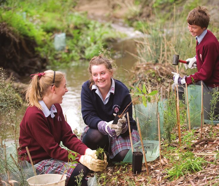
The Local Places Guide is a list of more than 100 local
places within the SA Murray-Darling Basin. We hope
this inspires you, your family and your friends to
connect with nature and your local environment.
The guide will be a living document that is updated
regularly. If you would like to contribute information,
please contact your local NRM Education Officer.

                                                                                          Photo
Whether you are planning a family day trip, overnight
stay or school excursion, the guide aims to make

                                                                                            credit:
it easier for you by highlighting facilities, unique

                                                                                                    Paul W
features and activities to do - and it’s all right in your
backyard. There is something in here to suit everyone,

                                                                                                   ite     h
and you may even find some places you never
thought to visit.
Encouraging children to connect with nature and
their local environment will help them to develop a
sense of belonging and care for that environment
into the future.
By visiting local places you and your family can
learn about and take action on issues and develop a
connection with your community.
The guide includes:
• Local parks, wetlands and bushland areas suited to
   families and school/group visits.
• Local producers or businesses who offer provision
   for schools to visit and learn about farming, food
   production, food miles and/or natural resource
   management.
• Locations suitable for large groups or school
   camps and excursions.
• Suggestions for opportunities and activities to be
   undertaken at each site along with the facilities
   available.
The latest version of the guide, along with many
relevant ‘connecting with nature activities’ are
available on our website:
www.naturalresources.sa.gov.au/samurraydarlingbasin/education

                                                                Local Places Guide / 2019 / pg 2
SA Murray-Darling Basin Region
This map shows the entire Murray-Darling Basin region and highlights
the towns (in blue) which are the location of, or closest to the local
places featured in this guide.

                                                                         Local Places Guide / 2019 / pg 3
Contents
Ashbourne                Page 5
Barmera                  Page 6-7
Berri                    Page 8-10
Blanchetown              Page 11
Burra                    Page 12
Cadell                   Page 13-14
Cambrai                  Page 15
Cobdogla                 Page 16
Coorong                  Page 17
Currency Creek           Page 18
Goolwa                   Page 19-20
Hindmarsh Island         Page 21-22
Jervois                  Page 23
Karoonda                 Page 24
Kingston-on-Murray       Page 25
Lameroo                  Page 26
Langhorne Creek          Page 27
Littlehampton            Page 28
Loxton                   Page 29-31
Mannum                   Page 32
Meadows                  Page 33
Meningie                 Page 34
Milang                   Page 35
Monarto                  Page 36-37
Moorook                  Page 38
Morgan                   Page 39
Mount Barker             Page 40-41
Mount Compass            Page 42
Murray Bridge            Page 43-45
Nairne                   Page 46
Overland Corner          Page 47
Paringa                  Page 48-49
Pinnaroo                 Page 50
Renmark                  Page 51-52
Strathalbyn              Page 53
Swan Reach / Nildottie   Page 54-55
Tailem Bend              Page 56
Tintinara                Page 57
Waikerie / Ramco         Page 58-60
Wellington               Page 61
Contact details          Page 62

                                      Local Places Guide / 2019 / pg 4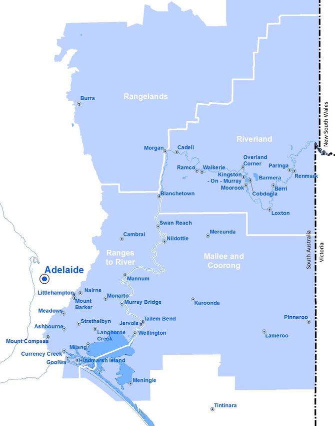
Ashbourne
Cox Scrub                           Activities/topics:
                                    Native flora and fauna
Conservation Park
                                    Birdwatching
The park is popular for
bushwalking and birdwatching.       Geocaching
The landscape of tall shrubland     Bushwalking
provides habitat for birdlife,
                                    Further information:
including honeyeaters and
                                    www.parks.sa.gov.au
yellow-tailed black cockatoos.
It hosts many walking trails
and opportunities to enjoy the
                                    Mount Magnificent
scenery - it’s especially vibrant   Conservation Park
in the spring when all the native   The Heysen Trail passes
wildflowers are out.                through this park situated on
Location:                           the eastern slopes of the Mount
                                    Lofty Ranges.
9 km south of Ashbourne SA.
Access via Bull Creek Road.         A spur trail through the
                                    forest takes you to the Mount
Facilities:                         Magnificent trig point, where
Walking trail                       you will be greeted with amazing
                                    views of the surrounding
Activities/topics:                  countryside.
Camping
                                    Location:
Birdwatching
                                    14 km south-east of Ashbourne
Bushwalking
                                    SA. Access from Mount
Mallee studies                      Magnificent Road or Blackfellows
Bushwalking                         Creek Road.
Native flora and fauna              Facilities:
Further information:                Walking trail
www.parks.sa.gov.au                 Activities/topics:
                                    Native flora and fauna
Kyeema Conservation                 Birdwatching
Park                                Bushwalking
The area was once mined for
alluvial gold for several years     Further information:
until it was abandoned in 1890      www.parks.sa.gov.au
due to low yield.
A few years later some of
the area was cleared for pine
plantations before being used as
a labour prison reserve.
Location:
10 km north-east of Ashbourne
SA. Access is via Woodgate Hill
Road.
Facilities:
Walking trail                                                          Photo credit: Sarah Lance

                                                                                           Local Places Guide / 2019 / pg 5
Barmera
Lake Bonney                          Loch Luna Game
The freshwater lake was first seen   Reserve
in 1838 by Europeans Joseph          Explore the stunning, peaceful
Hawdon and his fellow drover,        floodplains and wetlands of
Charles Bonney while herding         Loch Luna Game Reserve and
300 cattle along the banks of        the adjacent Moorook Game
the Murray. Lake Bonney has          Reserve. These locations provide
a lot of history and is a unique     important habitats for many
environment to search and            aquatic birds and mammals.
explore.
                                     *Check when duck season is
The first settlement in the area     scheduled as these parks are
grew up around the Overland          included in the game reserves that
Corner Hotel which was built         shooters can utilise*
in 1859 and became a popular
spot with drovers moving their       Location:
stock from New South Wales into      Loch Luna is located on western
South Australia.                     side of Lake Bonney and can
In 1928 Barmera was declared         be accessed from near the
a town and currently has over        intersection of Morgan Road
4,000 residents. Even though the     and Queen Elizabeth Road,
town is well developed, there are    Barmera SA.
still sites around Lake Bonney       Facilities:
that have natural vegetation and     Toilet facilities available in
bush areas.                          nearby townships of Barmera or
Location:                            Cobdogla.
Barmera SA. Access to lake           Walking trail
foreshore from Dean Drive and        Activities/topics:
Queen Elizabeth Drive.
                                     River/creek studies
Facilities:                          Bushwalking
Toilet facilities, lawned areas,     Native flora and fauna
and shade suitable for picnic
                                     Birdwatching
lunches (all located on the main                                          Photo credit: Irene Wegener
foreshore).                          Canoeing
                                     Geocaching
Activities/topics:
Water monitoring                     Further Information:
Canoeing                             www.parks.sa.gov.au
Local history
Native flora and fauna
Geocaching
Further information:
www.barmera.net.au

                                                                                              Local Places Guide / 2019 / pg 6
Barmera (continued)
Chambers Creek                       Nappers Ruins
Home to large populations of         This site was originally a hotel
waterfowl and other bird life.       for the workers on Cobdogla
Chambers Creek is a well-known       Station. Interpretive information
wetland reserve made up of           is included at the site.
many creeks and shallow swamps
                                     Location:
to explore. There are also several
sites along the creek suitable for   Situated on the north side of
camping.                             Lake Bonney, off Morgan Road,
                                     Barmera SA.
Location:
Off Morgan Road, Barmera SA.         Facilities:
                                     Closest toilets located on the
Facilities:                          north shore of Lake Bonney near
Closest toilets located at nearby    the boat ramp.                      Photo credit: Paul White
Lake Bonney foreshore.
                                     Activities/topics:
Canoe trail
                                     Local history
Activities/topics:                   Geocaching
Birdwatching
                                     Further information:
Creek studies
                                     www.barmeratourism.com.au
Water monitoring
Further information:
www.barmeratourism.com.au

  When visiting local bushland, reserves and national parks
  it’s important that you enjoy your time whilst conserving
  the very values that make them special.
  Please remember the seven Leave No Trace principles:
  1. Plan ahead and prepare
  2. Travel and camp on durable surfaces
  3. Dispose of waste properly
  4. Leave what you find
  5. Minimise campfire impacts
  6. Respect wildlife
  7. Be considerate of your hosts and other visitors
  More information can be found at:
  www.lnt.org.au

                                                                                             Local Places Guide / 2019 / pg 7
Berri
Murray River National                 Facilities:
Park - Katarapko                      Toilets situated near Campsites 6,
                                      7, 8 and 28.
There are three main sections
of the Murray River National          Walking/bike trail
Park: Katarapko, Lyrup Flats and      Activities/topics:
Bulyong Island in Renmark.            Canoeing
The park features a floodplain        Bushwalking
landscape with several
                                      Birdwatching
permanent and semi-permanent
wetlands. This part of the park       Native flora and fauna
is made up of three sections:         River/creek studies
Katarapko Creek, Eckert Creek         Mallee studies
and Lock 4. One of the best           Threatened species studies
features of the park are the
interpretive walking trails.          Mallee drive (4WD access only)
                                      Water monitoring
Location:
                                      Local history
Near the township of Berri SA.
                                      Geocaching
Ngak Indau Wetland and                Further Information:
Walking Trail
(1.5 hour walk, 4.8 km loop)          www.parks.sa.gov.au
One of the most picturesque
walks of the park, winding
through the Ngak Indau
Wetlands.
Ngak Indau is an essential
breeding area for many forms of
wildlife including waterbirds.
Kai Kai Trail
(40 minute walk, 2 km loop)
It’s quite a popular walk for
schools. Many native plants
and animals can be seen along
the way.
Craggs Hut Walking Trail                Please don’t forget
(40 minute walk, 2 km loop)             that most national
Step back in time to when               parks in SA now
European settlers walked this           require you to book
land. See the historic remains of
                                        and pay for your
the homes of the Craigies and
the Blands, and visit the grave of      campsite online.
Margaret Craigie.
                                        Check out the website
Interpretive signs tell the stories     to ensure you are
of the families.
                                        able to secure your
                                        favourite spot:
                                        www.parks.sa.gov.au

                                                                           Local Places Guide / 2019 / pg 8
Berri (continued)
Wilabalangaloo                         Martin Bend Wetland                  Photo credit: Helga Kieskamp
One hundred hectare National           and Walking Trail
Trust property on the banks
of the Murray River. The name
                                       (45-60 minute walk)
‘Wilabalangaloo’ is from an            Martin Bend Wetland is a
Aboriginal word meaning ‘place         favoured place for locals and
of the red, yellow and brown           tourists alike.
stones’ reflecting the colours in      It features five lagoons, with one
the cliff face along the river.        permanently connected to the
A marked walking trail and             river. A walking trail, developed
lookout on the property gives          by the Berri Lions Club takes
visitors magnificent views of the      you on a 2.8 km loop through
Murray River.                          floodplain habitat and is rich in
                                       bird life, with interpretive signs
Don’t forget to check out the
                                       along the way.
famous ‘robbers cave’ and
original mud hut.                      Brochures are available at the
                                       Berri Barmera Landcare office
Berri-Barmera Landcare is located
                                       at Wilabalangaloo, local tourist
at Wilabalangaloo. Landcare
                                       information centre or Natural
project officers are available to
                                       Resources Centre.
assist with school visits and tours.
                                       Location:
Location:
                                       Martin Bend Drive, Berri SA.
Old Sturt Highway, Berri SA.
                                       Facilities:
Facilities:
                                       Toilets adjacent to the Martin
Toilets
                                       Bend caretaker’s cottage near
Undercover area and BBQ                the river.
facilities (bookings required
                                       Walking/bike trail
through National Trust)
Walking trail                          Activities/topics:
                                       Birdwatching
Activities/topics:
                                       Bushwalking
Birdwatching
                                       Mountain bike riding
Native flora and fauna
                                       River/creek studies
Bushwalking
                                       Native flora and fauna
Mallee studies
                                       Water monitoring
River studies
                                       Wetland studies
Local history
Geocaching                             Further information:
                                       www.bblap.org.au
Further Information:
www.nationaltrust.org.au

                                                                                               Local Places Guide / 2019 / pg 9
Berri (continued)
Bella Lavender Estate                Jimmy James                         Photo credit: www.ashborn.com.au
The lavender farm with its           Monument
2500 plants of lavender is set       Jimmy James was a famous
on 5 acres of land amongst a         Aboriginal tracker who moved
backdrop of vines and olive trees.   to the Riverland in the 1940s.
Lavender is grown and distilled      His amazing tracking skills
to make body products.               were used to help the police in
Cafe times:                          tracking criminals, escapees and
Wednesday to Saturday                missing people.
10 am-8 pm,
Sunday and Monday                    Location:
10 am-4 pm.                          Riverview Drive, Berri SA.
Group and school bookings are        Facilities:
welcome to learn about lavender      Lawned river front nearby.
processing and production.
                                     Public toilets close at the Berri
Preferred visiting times these
                                     Marina/boat ramp, or in the
groups are in the morning
                                     main street.
between 10.00 and 11.30 am,
and bookings are essential.          Walking trail
Closed Tuesdays.                     Activities/topics:
Location:                            Indigenous culture
The farm and cafe is situated        River studies
at 19 Dalziel Rd, Glossop SA (in     Geocaching
between the towns of Berri
                                     Further Information:
and Barmera).
                                     www.monumentaustralia.org.au
Facilities:
Toilets
Cafe
Activities/topics:
Lavender processing and
production for school groups
Shop for local produce and
manufactured items
Putt putt golf (costs involved)
More information:
www.bellalavender.com.au
Ph 08 8583 1184

                                                                                           Local Places Guide / 2019 / pg 10
Blanchetown
Brookfield Before the establishment as a
wildlife sanctuary, the land had
Conservation Park been cleared for sheep grazing
Home to the southern hairy- and production of wood fuel
nosed wombat, Brookfield and charcoal.
Conservation Park is managed Get involved with one of their
by Conservation Volunteers visitor and volunteer days.
Australia (CVA) who undertake a
range of volunteer activities both Location:
in the park and the surrounding Moorunde is 13 km from
area, with a focus on the research Blanchetown SA, on the southern
of threatened species. side of the Sturt Highway.
Sections of the park are open Facilities:
to the public to explore this
Camping as part of volunteer
limestone country and enjoy
weekends (not open to public).
opportunities to see wombats,
kangaroos and bird life such Self-guided nature trail.
as the rare bush stone-curlew, Activities/topics:
ground cuckoo-shrikes and Native flora and fauna
Australian owlet-nightjars. Birdwatching
Members of the public can Bushwalking
volunteer time to assist with
research within the park. Further information:
www.nhssa.com.au
Location: Email: info@nhssa.com.au
Brookfield Conservation Park Ph 0417 881 658
is located 11 km west of
Blanchetown SA. Access is via Lock 1
Sturt Highway. Blanchetown was one of the
Facilities: first river settlements in South
Australia. Lock 1 was the first
Toilets
of 13 locks and weirs built on
Picnic areas the Murray River and was
Walking trail completed in 1922.
Activities/topics: Location:
Blanchetown SA.
Birdwatching
Bushwalking Facilities:
Toilets
Native flora and fauna
Southern hairy-nosed wombats Activities/topics:
Assist with research/volunteering River regulation/locks and weirs
Further information: Birdwatching
www.parks.sa.gov.au Water monitoring
Local history
Conservation Volunteers
Geocaching
Australia Ph 08 8212 0777
Further information:
Moorunde Wildlife www.murrayriver.com.au
Reserve
Consists of almost 7,000 ha of
mallee country. Photo credit: Karen Collins
Local Places Guide / 2019 / pg 11Burra
Red Banks Burra Creek Gorge
Conservation Park Also known as Worlds End Gorge,
Burra Creek Gorge is Burra’s
Red Banks Conservation Park fascinating hidden attraction. The
features a scenic landscape area is rich in biodiversity, with
of rugged gorges, spring-fed large river red gums and mallee
waterholes, and remnant old scrubland present. Local students
growth mallee trees. are involved in tree planting
Palaeontologists have called every year.
this area one of the richest
megafauna sites in Australia. Up Location:
until approximately 65,000 years Worlds End Highway 26 km
ago, Red Banks was home to south of Burra SA.
Diprotodons, a huge marsupial
Facilities:
that weighed between one to
two tonnes, often likened to a Toilets
giant wombat. Campsites
Take the fascinating landscapes Picnic areas
of change interpretative walking Walking trail – part of the
trail which passes through deep Heysen Trail
red earth gorges and permanent
Activities/topics:
waterholes to learn what the
landscape was like when these Native flora and fauna
large marsupials were alive. Indigenous culture
Location: Birdwatching
Red Banks Conservation Park is Bushwalking
located 15 km east of Burra SA. Camping
Access the park from Burra via Creek studies
the Burra-Morgan Highway and Water monitoring
then the Eastern Road (unsealed).
Further information:
Facilities:
www.visitburra.com
Public toilets located in Burra
town centre. Photo credit: Bill Doyle
Picnic Areas
Campsites
Walking trails
Activities/topics:
Geocaching
Archaeology/Palaeontology
Native flora and fauna
Birdwatching
Bushwalking
Camping
Further information:
www.parks.sa.gov.au
www.goyder.sa.gov.au/
Diprotodon
Local Places Guide / 2019 / pg 12Cadell
Cadell Wetlands / The Riverfront Walk And
Malcolm Moss Nature Canoe Tree
Trail The walk features limestone cliffs,
Walk along the Malcolm Moss bird life, and an Aboriginal canoe
Nature Trail an easy grade trail tree. The bark cut from the tree
that weaves through and around would have been used to make a
the wetlands. shallow canoe for fishing and to
cross the river.
There are numerous bird hides to
stop at along the way and plenty Location:
of birdlife to see. River Bank via River Terrace,
Cadell SA.
Location:
Dalzell Road, Cadell SA. Facilities:
Nearby toilets at town centre
Facilities:
BBQ
Toilets
Picnic area
BBQ
All located at Kings Riverside
Picnic area
Reserve, Cadell
All located at Kings Riverside
Walking trail
reserve, Cadell
Walking trail Activities/topics:
Bushwalking
Activities/topics:
Birdwatching
Wetland studies
Indigenous studies
Birdwatching
River studies
Bushwalking
Water monitoring
Further information:
Further information:
www.cadell.org.au
www.cadell.org.au
Photo credit: Irene Wegener
Local Places Guide / 2019 / pg 13Cadell (continued)
Hogwash Bend
Conservation Park
The 286 ha Hogwash Bend
property near Waikerie/Cadell
on the River Murray was
acquired by the state and federal
governments under the National
Reserve System program to
protect the largest breeding
colony of regent parrots in South
Australia.
There are thought to be only
300 breeding pairs of the
parrot along the River Murray.
Around 50 pairs use the ideal
breeding habitat of mature river
red gums, nesting sites and
large areas of mature mallee
scrubland. Hogwash Bend plays
an substantial role in the bird’s
future. Photo credit: Karen Bishop
Location:
At the end of Hogwash Road,
Cadell SA.
Facilities:
Closest public toilets located at
Cadell town centre.
Activities/topics:
Threatened species studies
Birdwatching
Bushwalking
Water monitoring
Further information:
www.parks.sa.gov.au Photo credit: Karen Bishop
Local Places Guide / 2019 / pg 14Cambrai
Meldanda Campsite Marne Valley
In 2003, a ten-year plan was put Conservation Park
into motion to develop Meldanda
The 94 ha park consists mostly
as a campsite providing hands-
of riparian (river red gum)
on educational experiences to all
vegetation which meets mallee
South Australian students as well
vegetation.
as outdoor activities for youth-
oriented clubs and organisations. It is home to many species of
birds including less common
The campsite is managed by
species like purple-backed
Cambrai Area School and is
fairywren (variegated fairywren)
available for school camps
and red-capped robin.
and excursions.
Location:
Location:
Havelberg Road Cambrai, SA.
Bandilla Road, Cambrai SA.
Facilities:
Facilities:
Public toilets located at Sedan
Toilets or Cambrai.
Dormitories Walking trail
Showers
Activities/topics:
Kitchen
Bushwalking
Recreation room
Native flora and fauna
Activities/topics: Birdwatching
Creek studies
Birdwatching
Bushwalking
Native flora and fauna
Native grasses
Bush tucker
Indigenous culture
Butterflies
Bat monitoring
Geocaching
Further information:
Ph 08 8564 5028
www.cambraias.sa.edu.au
Local Places Guide / 2019 / pg 15Cobdogla
Kaiser Strip
Kaiser Strip is a hidden gem
which many people may not have
visited. If you’ve ever wondered
what that ‘strip’ of bush and
water is on your left when
heading over the Kingston-on-
Murray Bridge towards Waikerie,
that’s Kaiser Strip!
There are picturesque campsites
tucked away behind large river
red gums and reeds. It’s a great
place to explore, and the canoe
trail within Loch Luna Reserve
showcases stunning views and
abundant wildlife.
Location: Photo credit: Paul White
Situated along Shueard Road,
Cobdogla SA (southern side of
the Sturt Highway).
Facilities:
Toilets
Campsites (online booking)
Activities/topics:
River/creek studies
Canoeing
Birdwatching
Bushwalking
Water monitoring
Geocaching
Further Information:
www.parks.sa.gov.au
Please don’t forget
that most national
parks in SA now
require you to book
and pay for your
campsite online.
Check out the
website to ensure you
are able to secure
your favourite spot:
www.parks.sa.gov.au
Local Places Guide / 2019 / pg 16Coorong
Coorong National Park
Stretching more than 130 km,
Coorong National Park protects a
string of saltwater lagoons which
are sheltered from the southern
ocean by the sweeping sand dunes
of the Younghusband Peninsula.
A wetland of international
significance and important
archaeological site, the Coorong is
of enormous cultural significance
to the Ngarrindjeri people, with
ancient mounds of discarded shells
revealing archaeological evidence
of Aboriginal campsites over
thousands of years.
Location:
The park is located 200 km south- When visiting local
east of Adelaide SA. The park
bushland, reserves
is accessible via Meningie and
Kingston off the Princes Highway.
and national parks it’s
important that you
Facilities:
enjoy your time while
Toilets conserving the very values
Campsites that make them special.
Activities/topics: Please remember the
Coorong studies seven Leave No Trace
Birdwatching principles:
Indigenous culture 1. Plan ahead and
Ngarrindjeri culture prepare
Four-wheel driving 2. Travel and camp on Photo credit: Chris Koolmatrie
Further information: durable surfaces
www.parks.sa.gov.au 3. Dispose of waste
properly
4. Leave what you find
5. Minimise campfire
impacts
6. Respect wildlife
7. Be considerate of your
hosts and other visitors
More information can be
found at:
www.lnt.org.au
Photo credit: Paul White
Local Places Guide / 2019 / pg 17Currency Creek
Currency Creek Lions
Park
The park is a perfect spot for a
picnic, with the Currency Creek
running past. You can enjoy the
tall gums and be at one with
nature. As you walk upstream
from the park to the waterfall,
you will pass canoe trees.
On your walk to the head of
the waterfall, visit the historic
Currency Creek cemetery which
is the final resting place for many
river boat captains from the past.
Location:
Off Alexandrina Road, Currency
Creek SA.
Facilities:
Toilets
BBQ
Shelter
Walking trail
Activities/topics:
Indigenous culture
River studies
Bushwalking
Water monitoring
Macroinvertebrates
Further information: Currency Creek Photo Gallery www.tripmondo.com
www.visitalexandrina.com
Local Places Guide / 2019 / pg 18Goolwa
Barrages Tokuremoar Reserve
Between Lake Alexandrina, the Coastal Boardwalk
Coorong and Goolwa Channel
Tokuremoar Reserve is a
are barrages separating the River
significant site for traditional
Murray from the sea. These are
custodians Ramindjeri/
designed and operated to ensure
Ngarrindjeri.
the lakes and lower reaches of
the Murray remain fresh, not only It is a 70 ha site that contains
for environmental reasons but as rare and endangered indigenous
a water supply source. plant and bird species including a
coastal melaleuca forest.
Location:
Goolwa SA. Location:
Approx. 5.5 km from Goolwa
Facilities:
Wharf or 6 km from
BBQ Middleton SA.
Shelters
Facilities:
Activities/topics: Walking/bike trail
Water management Boardwalk
River regulation
Activities/topics:
Locks and weirs
Coastal vegetation and wildlife
Geocaching
Birdwatching
Further information: Indigenous culture
www.mdba.gov.au
Photo credit: Ben Simon
Local Places Guide / 2019 / pg 19Goolwa (continued)
Goowla Beach Carpark Bristow Smith Reserve
Lookout Nature Playspace
The boardwalk lookout at the The playspace features a 10
Goolwa Beach carpark provides metre long restored wooden
incredible 360 degree views fishing boat, parkour elements,
across to the hills, along the water play with a creek bed,
beaches and towns of Encounter sensory wall, climbing nets,
Bay, up to the Murray Mouth, basket swings, and stepping logs,
back over the Sir Richard along with an upgraded beach
Peninsula, across the Goolwa area, barbecues and shelters.
Channel and back to Hindmarsh
Island. It’s a great spot for Location:
connecting landscapes, having a Barrage Road, Goolwa SA.
visual find-a-spot activity or for Facilities:
reflections on places visited in Photo credit: Ben Simon
Toilets
the day.
BBQ
Location:
Shelters
Goolwa SA.
Activities/topics:
Facilities:
Connecting with nature
Toilets
Outdoor play
Shelter
Walking trail
Activities/topics:
Coastal vegetation and wildlife
Native flora/plant identification
Photo credit: Ben Simon
www.alexandrina.sa.gov.au
Local Places Guide / 2019 / pg 20Hindmarsh Island
Hindmarsh Island Lawari Conservation
Landcare Nursery Park
The Hindmarsh Island Landcare Lawari Conservation Park
Group is working to conserve comprises two former grazing
and re-establish habitat on the properties. It covers important
island. By preserving existing wetlands containing a diverse
remnant vegetation, and using array of habitats that support
local Indigenous species to threatened fish and water bird
revegetate, they aim to restore species.
the health and resilience of the The Lawari Conservation Park
local natural ecosystem. supports three native fauna
Location: species of national conservation
Ferryman’s Reserve Hindmarsh significance, and a further 30
Island SA. fauna and one flora species at
the state level, including the Far
Activities/topics: Eastern Curlew and Cape Barren
Conservation Goose.
Native flora/plant identification Location:
Further information: Off Denver road at the eastern
end of Hindmarsh Island.
www.communitynurseries.com.au
Facilities:
Sugars Beach The old Wyndgate homestead
A great local beach location serves as a Natural Resources
where you can explore and learn Office. Toilets, kitchen and
about the local environment. meeting facilities can be used by
arrangement.
Location:
Activities/topics:
Sugars Avenue Hindmarsh
Island SA. Birdwatching
Canoeing
Activities/topics:
Frog and fish monitoring
Fishing
Coastal vegetation and wildlife
Lookout
Coorong studies
Birdwatching
River studies Further information:
Coastal vegetation and wildlife General enquiries
Ph 08 8532 9100
Local Places Guide / 2019 / pg 21Hindmarsh Island (continued)
Mundoo Island Water monitoring
Mundoo Island is a privately Further information:
owned cattle and sheep station.
Bookings and enquiries:
This unique property is the last Ph 08 8555 2242
farming property on the River
Murray - where the river meets Email info@mundooisland.com.
the sea. The station is run over au
a series of islands nestled in the
mouth of the River Murray.
Due to the incredible wetland
features of Mundoo Island
Station, it is home to myriad
birdlife and native animals
including endangered and
vulnerable species.
Book a private historical or
birdwatching tour - marvel
at the diversity of the
unique freshwater/saltwater
environments, providing varied
habitat for numerous bird
species.
Accommodation is available for
small groups. School groups are
welcome, and there are many
exciting and interesting learning
opportunities.
NOTE: There is NO PUBLIC
ACCESS on Mundoo Island or the
government operated barrages.
ALL visits must be arranged.
Location:
Access is gained via Goolwa and
Hindmarsh Island.
Facilities:
Toilets
Camping
Accommodation (up to four
people)
Activities/topics:
Birdwatching
Frogs and fish
Coastal vegetation and wildlife
Water management
Local history
Photograph tours
Native flora and fauna
Local Places Guide / 2019 / pg 22Jervois (and surrounding areas)
Jervois Ferry Reserve
Small nature area at the river
near the Jervois ferry site.
Location:
Jervois Ferry Rd, Jervois SA.
Activities/topics:
River/creek studies
Water quality monitoring
Native flora and fauna
Birdwatching
Morphett Flora and
Fauna Reserve
This native scrub is maintained by
community volunteers. A great
place to learn about biodiversity
and local native flora and fauna.
The reserve is 18.3 Ha comprising
both planted and endemic native
vegetation. The soils include
sandy swales and brown sandy
loam over calcrete creating two
very different plant communities.
The 1.5 km walking track through
the reserve has information signs
about the vegetation.
Location:
Near Woods Point.
Lot 47 Jervois Rd, www.murraybridge.sa.gov.au
Woods Point SA.
Facilities:
Walking
Toilets (approx. 400 m from
main entrance at Woods Point
community hall).
Activities/topics:
Native flora and fauna
Birdwatching
Further information:
www.murraybridge.sa.gov.au
www.murraybridge.sa.gov.au
Local Places Guide / 2019 / pg 23Karoonda
Karoonda Pioneer Lowan Conservation
Park Park
The park features a nature trail This park of mallee scrub and
and bush walk showcasing the grey cypress pines is noted for its
local landscape. breeding populations of wedge-
tailed eagles and malleefowl.
Location:
East Terrace, Karoonda SA. Location:
13 km south-east of Bowhill
Facilities:
SA. Access is via the Bowhill-
Toilets, BBQ and playground Karoonda Road which provides
location in the main street. access to the eastern boundary.
Activities/topics: Facilities:
Native flora and fauna Public toilets located at Bowhill.
Birdwatching
Walking trail
Geocaching
Activities/topics:
Local history
Native flora and fauna
Further information:
Birdwatching
www.karoonda.com/karoonda-
Bushwalking
pioneer-park/
Further information:
Karoonda Nature Park www.malleebound.com.au
Karoonda Nature Park features
nearly two km of signed and
unsigned walking trails through
virgin mallee scrub. Local
native flora and fauna including
echidnas are often observed.
Trails can be accessed from the
northern side of Pioneer Park.
Location:
East Terrace, Karoonda SA.
Facilities:
Toilets, BBQ and playground
location in the main street.
Walking trail
Activities/topics:
Native flora and fauna
Birdwatching
Bushwalking
Further information:
www.karoonda.com/lions-nature-
trail-and-bushwalk/
Local Places Guide / 2019 / pg 24Kingston-on-Murray
Banrock Station Kingston-on-Murray
Wetland Primary School
Self-guided walking trails wind Riverlinx Camp
their way around the restored
wetlands, mallee and flood The school hosts Riverlinx
plains. Several bird hides offer a camps for schools interested in
good opportunity to view many being involved in environmental
local species. learning programs.
The walking trails and boardwalks Students learn about the River
provide a unique chance to Murray, its wildlife and special
enjoy the restored wetlands, places, through a kids teaching
view abundant wildlife and learn kids process. Its a great way
about the role the wetlands play of experiencing some of the
in the River Murray system. wonderful things the Riverland
region has to offer.
Location:
Location:
Holmes Road, (off Sturt Highway),
Kingston-on-Murray SA. East Terrace, Kingston-on-Murray
SA.
Facilities:
Facilities:
Toilets
Toilets
Conference room
Hall and kitchen
Catering/restaurant
Camping facilities
Walking trails
Boardwalks Activities/topics:
Bird hides Birdwatching
Camping
Activities/topics:
River studies
Guided tours are available to
schools upon request. Native flora and fauna
Bushwalking Conservation
Birdwatching Water monitoring
Native flora and fauna Kids Teaching Kids
Conservation Further information:
Water monitoring www.komps.sa.edu.au
Wetland studies
Threatened species studies
Further information:
Ph 08 8583 0299
Local Places Guide / 2019 / pg 25Lameroo
Ngarkat Conservation Lake Roberts
Park A picturesque lake and park
Enjoy the peaceful surroundings located in the town of Lameroo.
of Ngarkat Conservation Park Location:
and take in the views over
Off Mallee Highway or Vardon
the park’s 270,000 hectares of
Terrace Lameroo SA.
vegetated sand dunes, mallee
and heath. The park has an Facilities:
abundance of wildlife including Toilets
the rare malleefowl and more Picnic area
than 120 species of birds.
Several walking trails allow you Activities/topics:
to see the wildlife and get a Water monitoring
better appreciation of the vast Geocaching
mallee landscape. Magnificent
Further information:
views can be enjoyed from many
of the hikes, including the two to www.southernmallee.sa.gov.au
three hour Tyms lookout hike. Photo credit: Paul Gillen
Location:
34 km south of Pinnaroo SA.
Access is via Princes Highway.
Facilities:
Toilets
Campsites
Walking trail
Activities/topics:
Birdwatching
Bushwalking
Native flora and fauna
Conservation
Threatened species
Mallee studies
Local history
Further information:
Contact the Natural Resources
office at Lameroo to speak to a
ranger about organising a school
visit or camp.
Ph 08 8576 3400
www.parks.sa.gov.au
Local Places Guide / 2019 / pg 26Langhorne Creek
Gollan’s Waterhole
(Mosquito Creek)
A popular location for water
monitoring and features a
nature trail.
Students from Eastern Fleurieu
School have been heavily
involved over the years with
improvements to the site.
Location:
Perrey Road off the Langhorne
Creek to Wellington Road,
Langhorne Creek SA.
Facilities:
Public toilets located in town.
Nature trail
When visiting local
Activities/topics: bushland, reserves
Bushwalking and national parks it’s
River/creek studies important that you
Water monitoring enjoy your time while
conserving the very values
Native flora and fauna
that make them special.
Further information:
Please remember the
www.langhornecreek.com
seven Leave No Trace
principles:
1. Plan ahead and
prepare
2. Travel and camp on
durable surfaces
3. Dispose of waste
properly
4. Leave what you find
5. Minimise campfire
impacts
6. Respect wildlife
7. Be considerate of your
hosts and other visitors
More information can be
found at:
www.lnt.org.au
Local Places Guide / 2019 / pg 27Littlehampton
Coppins Bush
Located at the rear of
Littlehampton Primary School,
this previous quarry site, where
old-growth blue-gums were
once felled and the understorey
cleared, now contains at least
114 native plant species.
It is a special place with a walking
trail where the community can
come to enjoy the local wildlife
and see what plants existed in
the area before the land was
cleared for agriculture, industry
and housing.
Location:
William Street, Littlehampton SA.
Facilities:
Public toilets located Old Princes
Highway, Littlehampton SA.
Walking trail
Activities/topics:
Native flora and fauna
Birdwatching
Bushwalking
Further information:
www.earthwiseharmony.com
www.bushcaresmajordayout.org
Local Places Guide / 2019 / pg 28Loxton
Loxton Riverfront Loxton Heritage and
Situated at the end of East Conservation Park
Terrace in Loxton, the town This community project features
riverfront is a shady, grassed area a homestead ruin, diverse
with easy access for visits. numbers of native plants,
To the west, at the end of lawned areas, garden beds and
McMillan Street is the town boat ornamental fruit trees.
ramp and the beginning of the The park depicts Loxton’s
floodplain walking trails which development from its early
weave through an arboretum of settlement through to today.
native trees and shrubs. An 800 metre walk through the
Bird and bat boxes provide park enables you to explore the
habitat in the trees and the history more closely.
backwater area good location for Explore the carved pine trees
birdwatching and other activities. located nearby.
Further along towards the
Loxton Caravan Park is the Lions Location:
Park with public toilets and the The heritage and conservation
famous tree of knowledge which park is located in the middle of
highlights historic flood levels. Bookpurnong Terrace (Karoonda
Highway) in Loxton SA, west of
Location: the round-about.
At the bottom of East Terrace, Facilities:
Loxton SA.
Public toilets located in the main
Facilities: street of Loxton approximately
Public toilets one km from heritage park.
Free public BBQs Walking trail
Walking trails
Activities/topics:
Activities/topics: Birdwatching
River studies Conservation
Macroinvertebrates Native flora and fauna
Water monitoring Local history
Geocaching Connecting with nature
Native flora
Further information:
Bushwalking
Ph 08 8584 8071
Birdwatching
Local history
Local Places Guide / 2019 / pg 29Loxton (continued)
Thiele’s Sandbar and Century Orchards
Lagoon Century Orchards consists of
Situated on the floodplain below 541 ha of almonds and 100 ha of
the water tower (opposite the wine grapes.
Loxton high school), sand mining School visits could include
activity is evident on the track learning about sustainable
down sandstone cliffs. irrigation and food production.
There is evidence of seeps at the Tour bookings are essential.
bottom of the cliff where the Location:
irrigation run off used to make its
Century Boulevard, Loxton SA
way onto the flood plain.
Thiele’s sandbar is a perfect Facilities:
picnic spot to base yourself as Toilets on site
you explore the floodplain and
Thiele Lagoon. Activities/topics:
Sustainable farming
Location:
Food production Photo credit: Paul White
Off Stasinowsky Court,
Loxton SA. Further information:
To arrange a school/class visit:
Facilities:
Ph 08 8584 4777
Campsites
www.centuryorchards.com.au
Nearest public toilets located in
town centre
Activities/topics:
River studies
Birdwatching
Bushwalking
Macroinvertebrates
Water monitoring
Geocaching
Native flora and fauna
Local Places Guide / 2019 / pg 30Loxton (continued)
Noora Evaporation There has been an ongoing
project that has seen many
Basin thousands of trees planted and
In 1978 the former Engineering hundreds of km direct seeded
and Water Supply Department with varying results, depending
(now known as SA Water) on the amount of rainfall
released a report titled ‘The received at the time.
South Australian River Murray
** Public access requires
Salinity Control Program’ which
permission/approval **
proposed six control measures to
mitigate the estimated 100,000 Location:
tonnes of salt that were entering Near Taldra, outside Loxton SA.
the Murray River annually in
South Australia from the existing Facilities:
evaporation basins. No toilet facilities
The main proposal was to pump Activities/topics:
the saline drainage water to a
Salinity research
new evaporation basin at Noora,
20 km east of Loxton. Water monitoring
Construction began in April Birdwatching
1980 and Stage 3 was officially Further information:
commissioned by the Hon. Jack Terri Minge
Slater M.P. on 31 July 1984. It was
Ph 08 8595 2202
estimated that the scheme would
remove 84,000 tonnes of salt
annually from the River Murray.
Since then increased efficiencies
in irrigation has seen the amount
of drainage water significantly
decrease to the point that there
was no longer a need to pump
to Noora.
With the development of Salt
Interception Schemes (SIS) in
recent years, Noora was able to
receive water from the Loxton
and Bookpurnong SIS initially,
with further investigations
showing a future need for other
SIS from Murtho and Pike.
More land was acquired to
enable a 50 year plan to be
put in place. To provide a
buffer between Noora basin
and adjoining landowners,
approximately 70,000 trees were
planted around the 33 km border,
as well as many rows that were
direct seeded.
Local Places Guide / 2019 / pg 31Mannum
Hermann Gass Bird Lenger Reserve
Sanctuary This 95 ha property was gifted
A beautiful location on the to the National Trust of South
banks of the river. The sanctuary Australia (NTSA) as a bird
features a boardwalk with a sanctuary in 1978.
viewing platform from which a Location:
large variety of birdlife can be Purnong Road, near Mannum SA.
spotted. Also known as ‘The Springs.’
Local history fact: Hermann Gass
Facilities:
was the manager of the Mannum
Club and during his retirement Nearest public toilets located
he would come down to this Randell St Mannum near the
spot to feed the pelicans, so the ferry.
sanctuary was named after him. Activities/topics:
Bushwalking
Location:
Native flora and fauna
Purnong Road, Mannum SA.
Birdwatching Photo credit: John Montesi
Facilities:
Walking trail
Picnic area
Further information:
Nearest public toilets located
Randell St Mannum near the Ph 08 8202 9216
ferry. www.nationaltrust.org.au
Activities/topics:
Mannum Waterfalls
Wetland studies
The falls generally flow during
Birdwatching winter and spring. After rains
Local history they are fast flowing and a
Further information: spectacular sight.
www.mid-murray.sa.gov.au The waterfalls are fed from the
Adelaide foothills into Reedy
Creek and are only a five minute
drive on the Mannum to Murray
Bridge Road from the township
of Mannum.
Location:
Off Cascade Road, Tepko SA.
Facilities:
Toilets
Walking trail
Activities/topics:
Bushwalking
River/creek studies
Native flora and fauna
Birdwatching
Further information:
www.mid-murray.sa.gov.au
Local Places Guide / 2019 / pg 32Meadows
Kuitpo Forest
The forest is modelled as a
community forest, managed
for sustainable commercial
forestry while providing for the
conservation of native flora
and fauna and community use
for recreation.
There are both pine and native
forest areas. The Rocky Creek Hut
area is a great spot for a day trip
or school camp.
Location:
Kuitpo Forest office, Brookman
Road, Meadows SA.
Facilities:
Toilets
Campsites
Shelters
Walking/bike/horse trails
Activities/topics:
Native flora and fauna
Birdwatching
Bushwalking
Mountain bike riding
Further information:
Ph 08 8391 8800
www.forestry.sa.gov.au
Local Places Guide / 2019 / pg 33Meningie
Camp Coorong Shelters
Camp Coorong was established Walking trail
in 1985 after the Ngarrindjeri Activities/topics:
people recognised the need for a
River/lake studies
place where people can come to
learn about their heritage Indigenous culture
and culture. Birdwatching
By visiting Camp Coorong, Local history
people will develop a better Further information:
understanding of Ngarrindjeri
traditions and allows them to www.coorongcountry.com.au
learn, interact and understand
Ngarrindjeri people’s connections Lions Bushwalking
to the land, flora and fauna. Trail
Location: Walking trails meandering
23 Seven Mile Rd, Meningie SA. through natural scrubland and
is home to several endangered
Facilities: native orchids.
Dormitories
Location:
Toilets
Bowman Street, Meningie SA.
Showers
Kitchen Facilities:
Museum Walking trail
Recreation facilities Public toilets located at Lions
Park, Princes Highway, Meningie.
Activities/topics:
Activities/topics:
Ngarrindjeri culture
Native flora and fauna
Bush tucker
Bushwalking
Local history
Native flora and fauna Further information:
www.coorongcountry.com.au
Further information:
www.ngarrindjeri.com
Meningie Lookout
Great 360 degree views of
Meningie Pelican Path Meningie and surrounds.
Meningie’s interpretive path
meanders along the lakefront of Location:
Lake Albert. Lookout Road, Meningie SA.
Visitors will learn about the
European, Indigenous and
environmental history of the
Meningie region.
Location:
Lake Albert Lakefront,
Meningie SA.
Facilities:
Toilets
Photo credit: Samantha Blight
Local Places Guide / 2019 / pg 34Milang
Nurragi Conservation Tolderol Game
Reserve Reserve
Containing a wide variety of Tolderol Game Reserve is an area
wildflowers and wildlife, the of 428 ha on the edge of Lake
reserve features a popular Road. There are extensive areas
nature trail. The reserve contains of samphire, reed and sedges
remnant mallee vegetation in with large open areas of water.
a highly developed agricultural A series of 17 ponds have been
region. constructed, some of which are
Within this region, less than 2% flooded to provide habitat for the
of the native vegetation remains. waterbirds which use the reserve.
There are over 300 different *Check when duck season is
Indigenous plant species present scheduled as this area is included
on the reserve, of which over in the game reserves that shooters
30% are of regional significance. can utilise*
Location: Location:
Following the old Sandergrove to Lake Alexandrina, near Milang
Milang railway line, Milang SA. SA. Access via Dog Lake Road.
Facilities: Facilities:
Walking trail Campsites (online booking)
Activities/topics: Picnic table
Native flora and fauna Public toilets located in Milang
Birdwatching Activities/topics:
Indigenous culture River/lake/wetland studies
Geocaching Native flora and fauna
Bushwalking Birdwatching
Further information: Bushwalking
www.nationaltrust.org.au Further information:
www.parks.sa.gov.au Photo credit: GWLAP
Local Places Guide / 2019 / pg 35Monarto
Monarto Zoo although birdlife present may
depend on what is flowering at
Education the time you visit.
The Education team offers
an exciting range of hands- Location:
on learning experiences for Ferries McDonald Road, Monarto
students to connect with nature, South SA.
learn about conservation and
Facilities:
contribute to making a better
world. Daytime and overnight Walking trail
programs are available. Activities/topics:
Location: Native flora and fauna
Old Princes Highway, Birdwatching
Monarto SA. Bushwalking
Facilities: Further information:
Indaba Bush Camp www.parks.sa.gov.au
Toilets
Bistro Monarto Conservation
Walking trail Park
Activities/topics: The park comprises remnant
Threatened species mallee woodland, dry heathland,
native pines and broombush
Native flora and fauna
thickets typical of the area before
Birdwatching European settlement.
Leadership activities
More than 25 species of fungi
Bushwalking have been identified here and
some can be found along the
Further information: walking trails throughout spring.
www.zoossa.com.au Location:
Ferries McDonald Road,
Ferries McDonald Monarto SA. Photo credit: Callie Nickolai
Conservation Park Facilities:
Enjoy a short loop walk in the Walking trail
north-eastern corner of the
semi-arid park. Activities/topics:
The park comprises remnant Native flora and fauna
mallee woodland, dry heathland, Fungi species
native pines and broombush Birdwatching
thickets typical of the area before Bushwalking
European settlement
and farming. Further information:
Don’t ignore the fantastic flora www.parks.sa.gov.au
of the park, there’s always
something in flower in Monarto
throughout the year. This walk
is frequented by birdwatchers,
Local Places Guide / 2019 / pg 36Monarto (continued)
Monarto Woodland Monarto Sporting
Conservation Park Complex
The Monarto Woodlands The location features a scrub
Conservation Park extends about block which is great for exploring
15 km along the south eastern and connecting with nature.
freeway from the edge of Murray
Bridge west towards Callington. Location:
It provides important habitat for Schenscher Road, Monarto SA.
more than 60 bird species, five of Facilities:
which are of state conservation
Toilets
significance.
Kitchen
Monarto is less accessible, but
the public is welcome to explore Multi purpose room available
the park lands. for hire
Activities/topics:
Location:
Native flora and fauna
Old Princes Highway,
Monarto SA. Birdwatching
Geocaching
Facilities:
Nearest public toilets located at Further information:
Schenscher Road, Monarto SA. www.murraybridge.sa.gov.au
Walking trails
Activities/topics:
Threatened species
Native flora and fauna
Birdwatching
Bushwalking
Further information:
www.parks.sa.gov.au
Local Places Guide / 2019 / pg 37Moorook
Yatco Lagoon
Yatco Lagoon is a wetland system
consisting of two lagoons. Up
until recently, the permanent wet
state of the lagoon has resulted
in a gradual decline in water
quality and health of fringing
trees and other vegetation in and
around the lagoon.
With the installation of a
structure connecting the lagoon
to the river, water levels can now
be managed. Yatco Lagoon has
been returned to its natural state
where it will be regularly wet and
dried as it was before the water-
regulating locks were installed in
the river system.
Visiting the lagoon when it is wet
and also when it is dry provides
great opportunity for comparison
of the local environment.
Location:
Loxton-Moorook Road,
Moorook SA.
Facilities:
Toilets
Campsites
Picnic areas
Boat ramp
All located in nearby in
Moorook township.
Activities/topics:
Canoeing
Wetland studies
Birdwatching
Water monitoring
River/wetland regulation
Geocaching
Local Places Guide / 2019 / pg 38Morgan
Morgan Conservation
Park
Morgan Conservation Park
conserves a system of lagoons,
swamps, creeks and River Murray
anabranches bordered by river
red gum woodlands.
The park’s wetlands provide
excellent opportunities for
canoeing and watching the
numerous species of birdlife
that inhabit the area. Look out
for regent parrots, pelicans and
white-faced herons.
Location:
Entry via Murbko Road,
Murbko SA.
When visiting local
Facilities: bushland, reserves
Campsites and national parks it’s
Walking trail important that you
enjoy your time while
Activities/topics:
conserving the very values
River/Creek studies that make them special.
Walking trail
Native flora and fauna Please remember the
seven Leave No Trace
Birdwatching
principles:
Canoeing
Bushwalking 1. Plan ahead and
prepare
Further information:
2. Travel and camp on
www.parks.sa.gov.au
durable surfaces
3. Dispose of waste
properly
4. Leave what you find
5. Minimise campfire
impacts
6. Respect wildlife
7. Be considerate of your
hosts and other visitors
More information can be
found at:
www.lnt.org.au
www.campingsouthaustralia.com
Local Places Guide / 2019 / pg 39Mount Barker
Duck Flat Community Laratinga Wetlands
Garden The wetlands were developed
The garden incorporates in the 1990s by the Mount
permaculture and organic Barker Council to enhance the
gardening principles, vegetable existing community wastewater
and herb gardens, habitat management scheme.
restoration, community arts, Laratinga Wetlands is made up of
meeting places and other three large ponds that naturally
community projects. clean the water by the plants
growing in the wetland.
Location:
These plants remove nutrients
Deer Avenue, Mt Barker SA.
(in particular nitrogen and
Facilities: phosphorus), so the water can
Closest public toilets located be reused to water gardens and
Caltex Mt Barker. irrigate parks and ovals.
Activities/topics: The wetlands also feature several
trails and boardwalks.
Community food garden
Food production Location:
Bald Hills Rd, Mt Barker SA.
Further information:
www.kitchengardenssa.com.au Facilities:
Toilets
Keith Stephenson Park Picnic shelters
In the centre of Mt Barker, a Walking trail
walking track connects this park
Activities/topics:
to Laratinga Wetland.
Wetland studies
Location:
Bushwalking
Off Wellington Road,
Native flora and fauna
Mt Barker SA.
Birdwatching
Facilities:
Geocaching
Toilets
Further information:
Walking trail
www.mountbarker.sa.gov.au
Activities/topics:
Wetland studies
Bushwalking
Native flora and fauna
Birdwatching
Further information:
www.mountbarker.sa.gov.au
Local Places Guide / 2019 / pg 40Mount Barker (continued)
Mount Barker Summit Purtinga Wetland
It’s a great little patch of nature, Extensive wetlands combined
and also has great views to Mt with a self-sustaining
Lofty, south over the lakes environmental centre are located
and Coorong. at Cornerstone College. It caters
There are also walking trails for environmental studies with
(both long and short) for visitors wet areas for practical activities
to experience the picturesque and a presentation space for
summit. lectures and project work.
Available for schools to visit.
Location:
Facilities:
Summit Road, Mt Barker SA.
Toilets open during school hours
Facilities: Walking trails
Closest toilets located at Kitchen
Laratinga Wetlands.
Classrooms
Walking trail
Outdoor amphitheatre
Activities/topics:
Activities/topics:
Native flora and fauna
Wetland/river/creek studies
Birdwatching
Bushwalking
Bushwalking
Native flora and fauna
Further information: Birdwatching
www.adelaidehills.org.au Geocaching
Totness Recreation Further information:
www.cornerstone.sa.edu.au
Park
Totness Recreation Park is Pioneer Park
located in the Central Mount
Lofty Ranges, approximately 2.5 A open spaced park which
km from Mount Barker and 5 km features walking trails and
from Hahndorf. sensory garden.
The park supports a variety of Location:
native plants and animals. 69A Mount Barker Road,
Hahndorf SA.
Location:
Milne Road, Mt Barker SA. Facilities:
Toilets
Facilities:
Walking trail
River/creek studies
Walking trail Activities/topics:
Native flora and fauna
Activities/topics:
Bushwalking
Native flora and fauna
Birdwatching Further information:
Bushwalking www.mountbarker.sa.gov.au
Further information:
www.parks.sa.gov.au
Local Places Guide / 2019 / pg 41Mount Compass
Mount Compass
Area School Swamp
Boardwalk
The Fleurieu Swamps are a
unique, endangered type
of wetland. They are rich in
biodiversity and a great place to
visit with students.
Location:
Off Arthur Road, Mt Compass SA.
Facilities:
Public toilets located on Victor
Harbor - Adelaide Road, Mt
Compass.
Boardwalk
Activities/topics:
Native flora and fauna
Birdwatching
Geocaching
Further information:
Contact Mount Compass Area
School to arrange a tour guided
by their students.
Ph 8556 8219
www.naturalresources.sa.gov.au/
samurraydarlingbasin
Local Places Guide / 2019 / pg 42Murray Bridge
Sturt Reserve Activities/topics:
Sturt Reserve is the major History
riverfront picnic area with Native flora
beautiful manicured lawned area, Biodiversity
trees, shelters, playground and
Bushwalking
even a bicycle track. It is also the
home of the International Pedal Further information:
Prix. A 24 hour event attracting www.murraybridge.sa.gov.au
school based teams from all over
Australia and around the world. Murray Bridge
Most of Murray Bridges’s major
events are conducted at this very
Community Nursery
popular riverside area. Opportunities to be involved in
monitoring, food gardening and
Location: plant propagation.
Charles Sturt Drive, Location:
Murray Bridge SA.
Greenlands Drive, Murray Bridge
Facilities: SA.
Toilets Facilities:
Shelters Toilet
Picnic areas Sustainable food garden
Playground Workshop
Fishing
Activities/topics:
Canoeing/kayaking
Birdwatching
Walking trail
wetland studies/water monitoring
Activities/topics:
Further information:
River studies
www.murraybridge.sa.gov.au
Birdwatching
The bunyip
Swanport Wetlands
Indigenous art
This River Murray wetland is
Further information: teeming with local wildlife.
www.murraybridge.sa.gov.au A boardwalk and viewing platform
have been constructed to provide
Murray Park access for nature lovers and sight
Murray Park is located on seeing.
Thomas Street and is the Location:
location for Murray Bridge’s
Enter from Frank Jackman Lookout
first cemetery. The biodiversity
on the south eastern end of
and quality of native vegetation
Swanport Bridge, Murray Bridge
within this reserve is diverse.
SA.
Location: Facilities:
Thomas Street, Murray Bridge SA. Toilet
Facilities: Walking trails
Toilets Boardwalk
Walking trail Activities/topics:
Local Places Guide / 2019 / pg 43Murray Bridge (continued)
Wetland studies Water/River/wetland studies
Photo credit: Gareth Oerman
Native flora and fauna Water slides
Birdwatching
Riverglades Wetland
Bushwalking
Riverglades Wetland is privately
Geocaching owned but publicly accessible on
Further information: Murray Drive or from Avoca
www.murraybridge.sa.gov.au Dell Reserve.
The wetland is home to many
Murraylands Aquatic native bird species and has a
walking trail so that visitors can
Centre walk in a loop and capture all the
The Murraylands Aquatic centre wetland has to offer.
is a division of DECD Sports
Swimming and Aquatic’s unit. Location:
It features a picturesque Avoca Dell,
lawned setting alongside the Murray Bridge East SA.
River Murray. The 10 acre site Facilities: Photo credit: Kate Mason
is securely fenced and is not Toilets at Avoca Dell Reserve.
available for public access during
school times. Walking trail
The Aquatic centre has free Activities/topics:
camping areas and more than Wetland studies
one kitchen facility. Alternatively, Native flora and fauna
there are some Apex cabins and
Birdwatching
a sailing club that can be hired
through the council. Further information:
Providing an efficient, cost www.toptouristparks.com.au
effective and responsive
specialist service to schools, to
Ettrick Conservation
assist students develop a range Park
of knowledge and skills. Ettrick Conservation Park is home
to one of the few remaining
Location:
examples of tussock grassland in
30 Water Street, this part of the Murray-Darling
Murray Bridge SA Basin.
Facilities: The park is also home to birds
Camping such as shy heathwren, hooded
Dorms robin, white-winged chough,
jacky winter, restless flycatcher
Kitchen and painted buttonquail.
Staff
Location:
Activities: Bowhill Road, Ettrick SA.
Water safety and survival
Activities/topics:
Rescue of others
Native flora and fauna
Mobility in, on and around water Birdwatching
Environment issues that impact Bushwalking
the river
Local Places Guide / 2019 / pg 44You can also read