User Requirements EOPEN - EOPEN project
←
→
Page content transcription
If your browser does not render page correctly, please read the page content below
EOPEN
           opEn interOperable Platform for unified access and analysis of Earth
                                        observatioN data
                                         H2020-776019

                                           D2.2
                          User Requirements
             Dissemination level: Public
    Contractual date of delivery: Month 6, 30 April 2018
           Actual date of delivery: Month 7, 11 May 2018 (v1.3 - 1 August 2019)
                   Work package: WP2 User Requirements & JDIG Architecture
                            Task: T2.2 User Requirements
                            Type: Report
                 Approval Status: Approved
                         Version: 1.3
                Number of pages: 60
                        Filename: d2.2-user_requirements_serco_master_v1.3.docx
Abstract
                                             Page 1
The main purpose of this document is to describe the User Requirements attained from
stakeholders, the identification of those stakeholders, along with the method of collection
and the results of stakeholder surveys and questionnaires that have been conducted.
User Requirements provide the fundamental underpinning of the EOPEN platform; by the
interpretation of survey’s results and the collection of specific datasets, technical partners
will be able to produce the customised product set that is one of the EOPEN project aims.
With each Use Case study providing different scenarios, the consortium has developed a
common survey structure that can be adapted by each PUC leader to meet each case study.

The information in this document reflects only the author’s views and the European Community is not liable for any use
that may be made of the information contained therein. The information in this document is provided as is and no
guarantee or warranty is given that the information is fit for any particular purpose. The user thereof uses the information
at its sole risk and liability.

                                           co-funded by the European Union

                                                              Page 2
History
Version     Date            Reason                      Revised by         Approved By
0.1                         Initial Draft               Francesco
                                                        Zaffanella
0.2         20 Apr 2018     Updated PUC1 input          Francesco
                                                        Zaffanella
0.3         23 Apr 2018     Comments and corrections    Dennis hoppe/
                                                        Ilias
                                                        Gialampoukidis
0.4         27 Apr 2018     Included PUC2 input         Anestis
                                                        Trypitsidis
0.5         28 Apr 2018     Comments and corrections    Guido Vingione/
                                                        Gabriella
                                                        Scarpino
0.6         5 May 2018      Included PUC3 input         Amara Graps
1.0         5 May 2018      Review and edits to whole   Tudor
                            document                    Pettengell/
                                                        Laurence
                                                        Marzell
1.1         9 May 2018      More PUC3 inputs            Amara Graps
1.2         10 May 2018     Updated document after      Francesco          Eliana Li Santi (Serco)
                            review                      Zaffanella
1.3         1 Aug 2019      PUC3 updates,               Jani Tyynelä /
                            reformatting                Amara Graps

Author list
Organisation       Name                                       Contact Information
AAWA               Michele Ferri                              Michele.ferri@abdve.it
AAWA               Daniele Norbiato                           Daniele.norbiato@abdve.it
AAWA               Francesco Zaffanella                       Francesco.Zaffanella@abdve.it
NOA                Anestis Trypitsidis                        Vsito@noa.gr
Serco              Tudor Pettengell                           Tudor.Pettengell@serco.com
Serco              Laurence Marzell                           Laurence.Marzell@serco.com
KU-eGISRS          Woo-Kyun Lee                               leewk@korea.ac.kr
KU-eGISRS          Wona Lee                                   supeanut@naver.com
NOA                Anestis Trypitsidis                        atrypitsdis@noa.gr
NOA                Vassilis Sitokonstantinou                  Vsito@noa.gr
NOA                Charalampos (Haris) Kontoes                kontoes@noa.gr
FMI                Amara Graps                                graps@psi.edu
FMI                Petteri Karsisto                           petteri.karsisto@fmi.fi
FMI                Jani Tyynelä                               jani.tyynela@fmi.fi

                                               Page 3
Executive Summary
This deliverable D2.2: User Requirements, builds upon the previous WP2 deliverable, D2.1: Use Case
Design. It provides a full report on stakeholders and their functional and non-functional
requirements, in relation to their Use-Case, that will underpin the development of the EOPEN
platform.
Deliverable D2.2 specifically describes the results, as well as the methods and rationale behind
collecting, collating, interpreting and elaborating User Requirements, following discussions with key
stakeholders.
This document contains:
•   The identification and description of key stakeholders;
•   The results and subsequent analysis of stakeholder interviews and questionnaires;
•   The identification of initial user requirements for each use case;
•   The identification of data sets to support these requirements.
Starting with the description of the contact methods, based on email or formal invitation, in line with
the procedure described in D 9.1, the document provides the description of the whole survey.
Questionnaires submitted to stakeholders have a common structure and a specific part for each case
study. EOPEN acquired information from more than 40 stakeholders, all questionnaires were
elaborated and the most important information was elicited.
Most important pieces of information coming from the questionnaires include the availability of
internet connections, of technological instruments and the level of expertise of stakeholders with EO
data.
From the results, it emerges that stakeholders are familiar with satellite imagery, early warning
systems and climate forecasts and they consider very important the improvement of those tools.
They consider the possibility to acquire satellite data the real engine for the development of these
systems.
This document at its conclusion provides an evidence base of User Requirements, ready to be
translated into EOPEN technical requirements.
 As deliverable D2.2 is a living document, this first version will be enriched and enhanced in
subsequent iterations, taking into account the further analysis work to be undertaken on the Current
Operating Model, and following feedback from stakeholders.
Keeping this deliverable as a living document allows the EOPEN solution to have the necessary scope
to react to changes in the environment and stay relevant to the stakeholders supporting the design
process.

                                                Page 4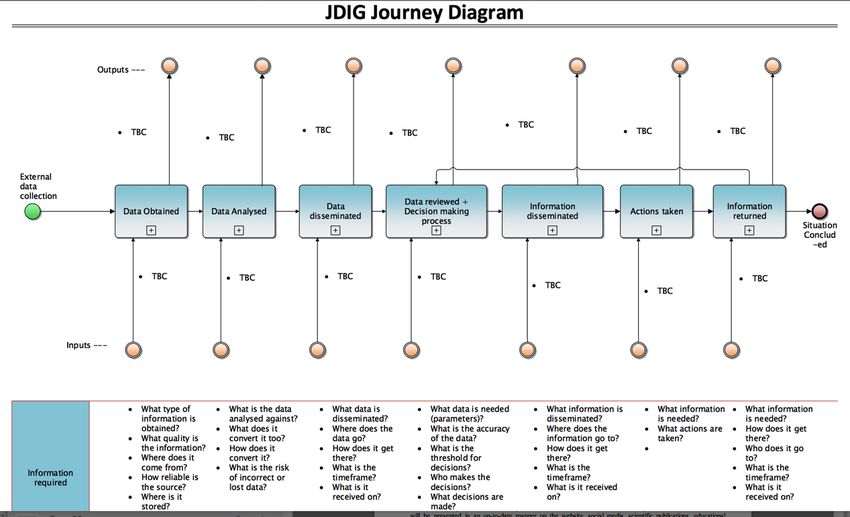
Abbreviations and Acronyms

ARD      Association of public service broadcasters in Germany
BMCO     Broadcast Mobile Convergence
COM      Current Operating Model
CES      Community Environmental Support
DAML     DARPA Agent Markup Language
DID      Digital Item Definition
DII      Digital Item Identification
DRM      Digital Rights Management
EBU      European Broadcast Union
EO       Earth Observation
ETSI     European Telecommunications Standards Institute
EWS      Early Warning System
FTIA     Finnish Transport Infrastructure Agency
ICF      Informed consents form
IS       Information sheet
IEEE     Institute of Electrical and Electronics Engineers
IP       Integrated Project
IPTC     International Press Telecommunications Council
IST      Information Society Technologies
JDGI     Joint Decision & Information Governance
JPEG     Joint Photographic Experts Group
MAF      Multimedia Application Format
MoSCoW   Must have, Should have, Could have, Would like but Won’t get
MPEG     Moving Picture Experts Group
NITF     News Industry Text Format
NoE      Network of Excellence
OWL      Ontology Web Language
OWL-QL   Ontology Web Language Query Language
OWL-DL   Ontology Web Language Description Language
RDF      Resource Definition Framework
RSS      Really Simple Syndication
STREP    Specific Targeted Research Projects
W3C      World Wide Web Consortium
XML      eXtensible Markup Language
SWRL     Semantic Web Rule Language
TOM      Target Operating Model

                                     Page 5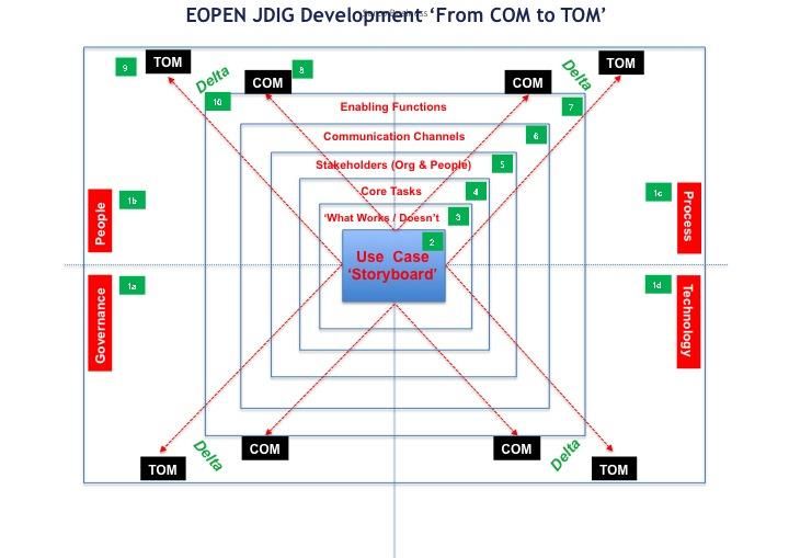
Table of Contents

1      INTRODUCTION ......................................................................................................... 8

Background and context ................................................................................................... 8

Definitions ........................................................................................................................ 8

Purpose of this Deliverable ............................................................................................... 8

2      DESCRIPTION OF USE CASES .................................................................................... 10

Scope of Use Cases ......................................................................................................... 10

3      METHOD OF ANALYSIS OF COM AND TOM............................................................... 12

Elaboration of the COM and TOM ................................................................................... 12
    3.1.1     CES journey & COM.............................................................................................................. 12
    3.1.2     MOSCOW Analysis & Delta Map .......................................................................................... 14
    3.1.3     TOM process flow(s) ............................................................................................................ 15
    3.1.4     Adaptation and Pilot ............................................................................................................ 15

4      IDENTIFICATION OF STAKEHOLDERS ........................................................................ 16

Description of stakeholders ............................................................................................ 16
    4.1.1     PUC1 Flood Risk Assessment and Prevention ...................................................................... 16
    4.1.2     PUC2 Food Security through Earth Observation dataset..................................................... 17
    4.1.3     PUC3 Monitoring the Climate Change through Earth Observation ..................................... 18

5      SURVEY METHOD AND MATERIAL PROVIDED .......................................................... 19

Information and dissemination material ......................................................................... 19
    5.1.1     PUC1 - Flood Risk Assessment and Prevention.................................................................... 19
    5.1.2     PUC2 - Food Security............................................................................................................ 20
    5.1.3     PUC3 – Climate Change........................................................................................................ 20

How stakeholders were engaged .................................................................................... 21
    5.1.4     PUC1 - Flood Risk Assessment and Prevention.................................................................... 21
    5.1.5     PUC2 - Food Security............................................................................................................ 23
    5.1.6     PUC3 – Climate Change........................................................................................................ 24

Feedback from Stakeholders ........................................................................................... 24
    5.1.7     PUC1 - Flood Risk Assessment and Prevention.................................................................... 24
    5.1.8     PUC2 - Food Security............................................................................................................ 25
    5.1.9     PUC3– Climate Change ........................................................................................................ 26

6      SURVEY REPORT ...................................................................................................... 27

Results............................................................................................................................ 27
                                                                   Page 6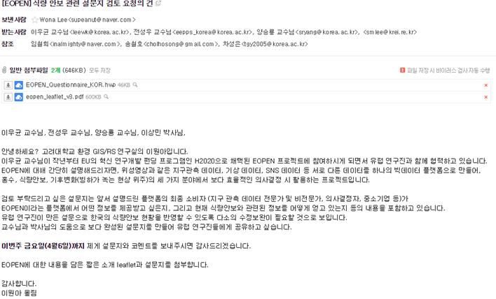
6.1.1    PUC1 Results ........................................................................................................................ 27
    6.1.2    PUC2 Results ........................................................................................................................ 31
    6.1.3    PUC3 Results ........................................................................................................................ 33

7     USER REQUIREMENTS FROM STAKEHOLDERS .......................................................... 37

Results for PUC1, general and specific Requirements ...................................................... 37

Results for PUC2, general and specific Requirements ...................................................... 39

Results for PUC3, general and specific Requirements ...................................................... 41

CONCLUSION .................................................................................................................. 43

8     ANNEXES: ................................................................................................................ 44

Questionnaire from PUC1 ............................................................................................... 44

Questionnaire from PUC2 ............................................................................................... 49

Questionnaire from PUC3 ............................................................................................... 57

                                                                    Page 7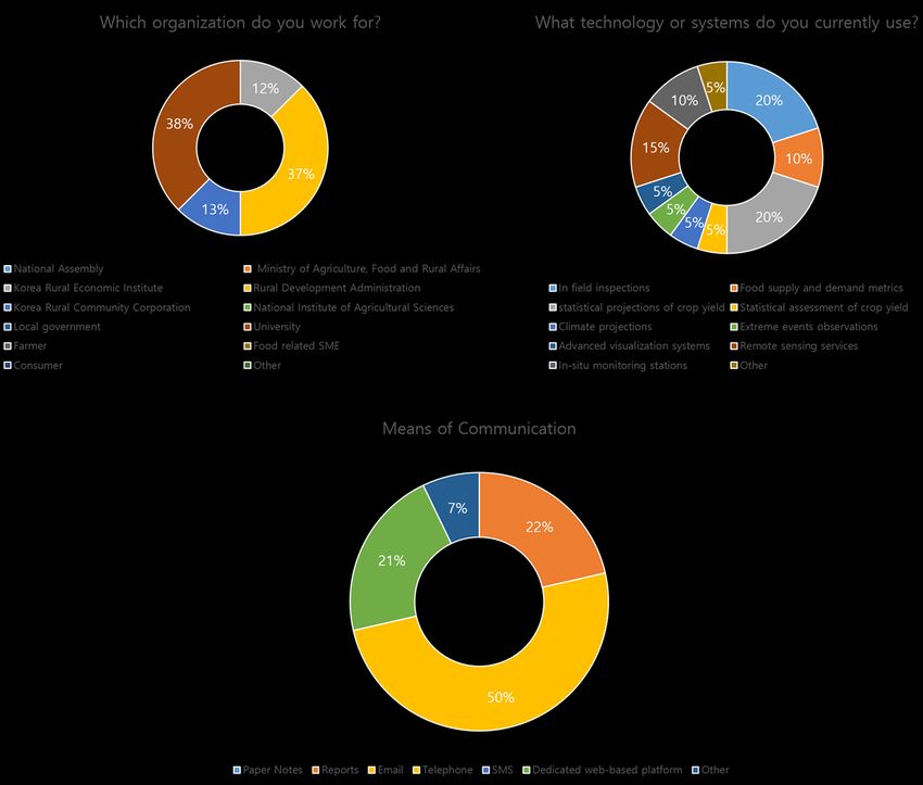
1    INTRODUCTION
Background and context
The activities under Work Package 2 (WP2) in EOPEN are devoted to the community needs of
environmental data into the EOPEN “Joint Decision & Information Governance” (JDIG) Architecture,
demonstrating the robustness and flexibility of the overarching EOPEN Platform. It therefore defines
a framework for integration of EOPEN in its various dimensions: organisations, processes,
technology, information and systems. The aim is to support the EOPEN system for real-life scenarios
that include specific local policies, environments and communities. We approach our Use Cases with
a ‘Storyboard’ scenario that describes through narrative: who and what is involved; the timings and
sequences and how the story starts, plays out and ends. The three Use Cases described here, allow
us to move towards giving place to specific EOPEN instances, as overviewed in the figure below:

                             Figure 1.a Background and context of WP2
Definitions
This section provides a list of definitions of the most relevant terms defined in EOPEN and used in the
course of this document:
    Joint Decision & Information Governance (JDIG): The EOPEN JDIG Architecture will support better
    informed decision making by end users involved in understanding how EO data, integrated into
    the wider data mix, is more effectively and efficiently used in support of sole or joint decision
    making. This objective will provide essential underpinning to support the innovation, technical
    and scientific objectives, and, ensure a shared and collective approach to achieving the benefits
    that EOPEN will bring for decision making that incorporates EO data into the wider data mix.
    Current Operating Model (COM): The Current Operating Model (COM) for EOPEN is the defined
    and agreed model of the end users in each Use Case, and how they are currently undertaking the
    CES activities as described in their provided scenarios.
    Target Operational Model (TOM): The Target Operating Model (TOM) for EOPEN is the defined,
    agreed end model of CES, which from the Use case, delivers to end users, improvements over
    their Current Operating Model (the COM) of CES. The EOPEN TOM has been achieved through
    several iterations: a process of iterative dialogue described within this deliverable, with the
    stakeholders that represent CES in each Use Case. Then adapted to their local context, validated
    through their Use Case Validation then tested and refined through their test bed.
Purpose of this Deliverable
The main purpose of this document is to describe the User Requirements attained from stakeholders,
the identification of those stakeholders, along with the method of collection and the results of
stakeholder surveys and questionnaires that have been conducted.
                                                Page 8
User Requirements provide the fundamental underpinning of the EOPEN platform; by the
interpretation of survey’s results and the collection of specific datasets, technical partners will be
able to produce the customised product set that is one of the EOPEN project aims.
With each Use Case study providing different scenarios, the consortium has developed a common
survey structure that can be adapted by each PUC leader to meet each case study.

This deliverable provides the foundation for understanding what potential end users want in an
EOPEN platform, in the context of their use case.
This document contains:
•   The identification and description of key stakeholders;
•   The results and subsequent analysis of stakeholder interviews and questionnaires;
•   The identification of initial user requirements for each use case;
•   The identification of data sets to support these requirements.

                                               Page 9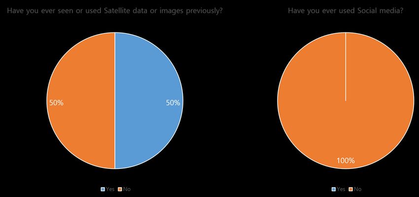
2   DESCRIPTION OF USE CASES
Scope of Use Cases
Three use cases have been defined, addressing respectively Flood Risk Assessment & Prevention,
Food Security, and Climate Change. They have been designed to provide complex multi-
organisational problems, which traditional methods and past technologies have struggled to
successfully resolve. The ability of the EOPEN platform to address and mitigate these problems to
any significant degree, will be considered a successful intervention and validate the value of the
EOPEN solution.
Use cases are a critical element to the success of the EOPEN project; stakeholders that are the actors
of each use case will also be users and testers of the EOPEN platform. To ensure that the platform
has longevity and utility after the end of the project, it is critical for it not only to address the current
stakeholder needs, but also to be flexible enough to adapt to future challenges.
By understanding what in the COM doesn’t work well, or where areas increase risk, as defined
through each individual Use Case, we need to understand what alternative or additional information
stakeholders need for their Target Operating Model (TOM). It is foreseen at the end of the project,
that the stakeholders will evaluate the EOPEN platform based upon its success in realising their
expectations, helping to overcome issues identified in the COM.
A summary of the Use Cases, also referred to as Community Environment Support (CES) storyboards,
addressed within EOPEN is provided in Table 1: Summary of the Use Cases. For further details on the
use cases, we refer readers to D2.1: Use Case Design.
                                   Table 1: Summary of the Use Cases
               Use Case         Description
UC1: Flood risk assessment The area within the Italian Eastern Alps river District is regularly
and prevention             affected by critical flooding from the Bacchiglione River and its
                           tributaries. Planned flood defences remain largely unfinished, and a
                           high risk of flooding therefore persists. Flood in the cities led to high
                           levels of water in the streets, causing many problems such as the
                           drowning of people, building damage and traffic problems. As
                           indicated in the Flood Directive (2007/60/CE) water authorities should
                           plan measures in order to aim at reducing risks by minimizing the
                           possible damages effects and losses that may result.

UC2: Food Security              The “Food Security” challenge comprises several different
                                components (food access, distribution, food supply stability, use of
                                food), and all come down to the fact that by 2050, the world must
                                feed 9 billion people, thus the demand for food will be 60% greater
                                than it was in 2016. Hence, a dedicated Sustainable Development
                                Goal (SDG) has been promoted by United Nations (UN) “Zero Hunger”,
                                aiming to end hunger, achieve food security and improve nutrition to
                                people. The food crises mainly arise from weather extremes, natural
                                disasters, societal crises, and other reasons such as population growth
                                and cultivation restrictions that require fast and efficient
                                communication for effective and timely decision making.
                                Within the scope of EOPEN’s food security pilot, the focus is on South
                                Korea which has experienced rapid population growth due to
                                urbanization, commercialization of the food chain and changes in diet.
                                In principle, South Korea has low food self-sufficiency rate among

                                                  Page 10
OECD1 countries mainly relying on imports of most major grains. In
case of an international grain supply failure, the country is exposed to
a food security crisis due to its high dependence on major grains and
limited exporting countries. Specifically, Statistics Korea2 announces
the results of Korea’s annual rice production forecasts in October each
year. According to the Ministry of Agriculture, Food and Rural Affairs
(MAFRA)’s key statistics on agriculture, forestry and food, in 2014,
Korea’s food self-sufficiency rate was 49.8% and grain self-sufficiency
rate was 24%. Major grains, except for rice, depend more than 90% on
imports. Since 2000, rice supply has been constantly oversupplied,
and it is estimated that the annual supply of rice is over 280,000 tons.
Therefore, the government’s market intervention is inevitable. One of
the main reasons for the overproductions of rice is the government’s
agricultural policy and active market intervention concentrated on
rice. The government would isolate the market if the price falls below
the target price and pay 85% of the price decreased. Apart from the
central government, local governments also have a lot of support
policies for rice farmers. Producers prefer rice farming because of the
relatively lower labour input due to high mechanization and stable
income compared to other crops.
UC3: Climate Change In the present and future climate change environment, the
average temperature in Finland is rising / will rise more (2°C by
2040), and precipitation will increase faster (5–10% by 2040)
than the global average. The changes are affecting winters more
than summers with the largest changes in the northern part of
the country: Finnish Lapland. Since the early 2000s, Finland has
taken a pro-active role in managing the Climate Change
situation nationally, with mitigation and adaptation plans. The
activities of the Transportation sector runs deeply through the
sectors: sustainable industry, land use planning and
construction, tourism and recreation as summers become
warmer, wetter and longer and snow packed regions shift
northward. Our use case begins with historical snow and
temperature data, supplemented by EO data, which support
Finnish Transportation Infrastructure Agency (FTiA)'s current
and future road maintenance for the Finnish drivers and riders.
Our Use Case continues with temperature and snow data
support for the Finnish Lapland communities who are, and will
be, experiencing the greatest climate change.
1 Organisation for Economic Co-operation and Development (https://en.wikipedia.org/wiki/OECD)
2 Statistics Korea: http://kostat.go.kr/portal/eng/index.action
Page 113 METHOD OF ANALYSIS OF COM AND TOM
Elaboration of the COM and TOM
To provide readers context to the Use Case evaluation process to attain requirements, in addition to
the stakeholder interviews and questionnaires, a brief overview of the COM/TOM process follows.
For further information we refer readers to deliverable, D2.1: Use Case Design.
3.1.1 CES journey & COM
The CES JDIG Journey, seen in Figure 3.b below and CES Storyboard seen in Figure 3.c, gives the
foundation for the full development of the Joint Decision & Information Governance Architecture,
the JDIG (D2.3). The JDIG is the framework from which the TOM is created and in which it resides.
The CES JDIG Journey has been based upon the research carried out by each of the EOPEN partners
and in a previous successful H2020 project (Unity).
It provides a unified, common and transferable view of the key stages that make up the end-to-end
activities of CES in each Use Case. As the analysis on the COM & TOM is still ongoing, the inputs and
outputs of the JDIG Journey below are still to be confirmed. An updated version will be included in
the next releases of this deliverable.
Figure 3.b. The CES JDIG Journey
Page 12Figure 3.c: Use Case Storyboard
A description of each of the terms in the multi-dimensional Figure 3.c follows on the next page.
In relating the CES JDIG Journey with the CES Storyboards, EOPEN will understand the context of the
wider community policies using multi-mode EO data. Data, in which the EOPEN TOM must eventually
sit and in which it must function; and thereby, how the outputs from the EOPEN TOM can integrate
downstream and form part of the ‘Big Data’ Use Case lifecycle.
This CES Journey provides the means for scalability and transferability both across the EOPEN
partners and across the EU as a whole. Our plan to achieve this goal is to deconstruct the three Use
Cases into a set of common key activities against the goals of the project.
For example, in each CES Journey and Storyboard is a set of environment conditions that signal
community actions by individuals, institutions and government bodies, which mitigate the
environmental hazard. EOPEN, as a platform to integrate satellite and social media environment
data, can better prepare a community with longer preparation time for such a hazard.
Communication with the communities and stakeholders about our available EOPEN tools are
included in our basic mandate.
Page 13Figure 3.c: COM Table
3.1.2 MOSCOW Analysis & Delta Map
The TOM described above, through the “What Works… Analysis” is used to identify the User, Data &
System requirements, which provide a view of the entirety of the desired Target Operating Model as
defined by the stakeholders within the CES journey.
This view however, has to be set in context with the reality of what can actually be achieved within
the parameters of the EOPEN project (e.g. cost and time) and by any constraints that exist within
such areas as policy, economics, legislation etc. A Subsequent analysis: MoSCoW is used to shape the
User, Data & System requirements into this more realistic TOM.
• The MOSCOW analysis is an acronym of Must have, Should have, Could have and
Want/Won’t have and has been used in conjunction with the Delta mapping to provide the
basis for our unified, common and amalgamated TOM which each Use Case partner will then
adapt to enable their Use Case.
The Delta Map has two axis, the COM and the TOM as described above. Once populated, the grid
enables the relationship, or Delta, between the CES COM and the Realistic TOM to be seen. This
Delta, provides the means to carry out a gap analysis to understand the similarities or differences
between the two, and what actions need to be taken going forward. The components that populate
this Delta are then subject to a further capability mapping analysis, providing the understanding to
realise the TOM operationally.
Page 14• Capability Mapping: The CES journey and the COM and TOM process flows, are the JDIG,
which acts as a golden thread throughout all CES activity.
Underpinning the JDIG, and all other functions and activities, whether CES or other, are five core
capability areas. These together, provide the Enabling Functions for the EOPEN outputs, as described
by the TOM, to become operational downstream. These 5 capability areas are: Governance
(Procedures, Legislation & Policy); Business Operations; System & Infrastructure; Organisations &
Personnel and Data/Information.
The capability mapping has looked at where the outputs from the Delta map and analysis sit, in
relation to the Information Value chain and its five capability areas, to identify where the subsequent
process flows that make up the TOM also sit.
Outputs also drive the high level functional requirements for the project’s technology aspects.
Together with the IT user requirements being undertaken in WP2, D2.2, this will refine what
technology enables the TOM and how it is used.
3.1.3 TOM process flow(s)
From the combined capability mapping and MoSCoW analysis that takes place in the Delta map as
described above, a process flow(s) giving more granularity to describe an achievable TOM (based
upon acceptable project and external factor constraints), is produced. This represents a generic,
amalgamated view of CES produced for review and comment by the EOPEN Use Case partners in
advance of their planned pilot events.
3.1.4 Adaptation and Pilot
In undertaking the review, as described above, of the ‘achievable’, common and amalgamated TOM,
each pilot partner seeks to identify and understand how it would, could or should work in relation to
their own specific scenario(s) of CES and their own existing (i.e. Current) and/or desired (i.e. Target)
operational models, structures and procedures.
The final version of the TOM used for each Use Case Test Bed, will be reviewed against the findings
and output from the Test Bed, updated where required to provide the basis, alongside the
technology elements of EOPEN, for the Test Beds post pilot.
Page 154 IDENTIFICATION OF STAKEHOLDERS
Description of stakeholders
To ensure stakeholder expectations and needs are taken into account from an early stage, it was
imperative that they be involved in the initial process of requirement elicitation. Therefore, once the
use cases were defined, the first task has been to identify the key stakeholders and gain their
support.
The tables below contain the name and description of the key identified stakeholders involved in the
interview or survey process. Stakeholders were contacted by the partner responsible for the
management of that Use Case; the means and material used for contact is described below in
chapter 5: Survey Method and Material Provided.
4.1.1 PUC1 Flood Risk Assessment and Prevention
Stakeholder Description
ARPAV This administration is the environmental agency of Veneto Region; inside
this office there is also the Copernicus contact person for Veneto Region
Regione Veneto This Administration is the office of Veneto Region Administration
Difesa Suolo responsible of land use, water, environmental planning, waste
management. This office is also responsible for cartography.
Regione Veneto This Administration is the office of Veneto Region Administration
Protezione Civile responsible of Civil Protection Volunteer (at regional scale, so about
formation, guidelines etc.), for Bulletins (Alert bulletins)
Genio Civile di This Administration is the operative office of Veneto Region
Vicenza Administration in water management (river maintenance, river project,
dikes etc.)
Corpo Nazionale dei The firefighters of Vicenza.
Vigili del Fuoco di
Vicenza
Provincia di Vicenza This is the provincial office of Civil Protection, similar to Veneto Region
protezione Civile Civil Protection office but at province level.
Comune di Vicenza Municipality of Vicenza.
Consorzio APV This Administration is a Land reclamation authority responsible for ‘’Alta
Pianura Veneta’’ basin.
Consorzio Brenta This Administration is a Land reclamation authority responsible for
‘‘Brenta’’ basin.
AAWA (Autorità di This Administration is the higher water authority in Veneto, Trentino-
Bacino dei fiumi Alto-Adige and Friuli region; it is also responsible for some international
Isonzo Livenza Piave basins like Timavo Basin (Slovenia). It is an office directly dependent from
Brenta-Bacchiglione) the Italian Environmental Ministry.
Page 164.1.2 PUC2 Food Security through Earth Observation dataset
Stakeholder Description
Korea Rural Economic A national agricultural policy research institute focused on the
Institute development of agriculture, rural areas and the food industry. The
institute is responsible for agricultural monitoring, Free Trade
Agreements, World agriculture information, agricultural policies,
Overseas crop market information, returning to farm support,
international cooperation such as the Korean Agricultural Policy
Experiences for Food Security(KAPEX). It carries over 30 different
projects per year.
Rural development A central government organization responsible for extensive agricultural
Administration research and services in Korea. The organization has 4 different
Research and Development institutes: National Institute of Agricultural
Science, National Institute of Crop Science, National Institute of
Horticultural and Herbal Science, National Institute of Animal Science.
The administration is focused on agendas such as basic agricultural
science and technology and development of steady supply of food and
state-of-art technology.
Korea Rural A national corporation which focus on rural community development
Community such as stable food production, development and management of
Corporation agricultural infrastructures. KRC has been contributing to the stable food
production for about 50 million people of the nation through the
development and management of agricultural infrastructures such as
reservoirs and pumping stations, and have also been improving the living
standard of rural and fishing villages. Major project of the corporation
includes food, water, climate, safety, research and training.
APEC Climate Centre The APEC plays an important role in the region in providing climate
information products and services based on a multi-model ensemble
prediction system. APEC Climate Centre aims to contribute to economic
growth in the APEC region and support the protection of lives and
property, the reduction of economic losses, and enhance economic
opportunities. The mission of APEC is to enhance the socio-economic
well-being of member economies by utilizing up-to-date scientific
knowledge and applying innovative climate prediction techniques
through climate prediction, interdisciplinary research, climate
information services and international cooperation.
Page 174.1.3 PUC3 Monitoring the Climate Change through Earth Observation
Stakeholder Description
Finnish Transport The Finnish Transport Infrastructure Agency (FTIA), is a Finnish
Infrastructure Agency government agency responsible for the maintenance of Finland's
road, rail, and waterway systems.
Reindeer-grazing These contacts represent reindeer herding practioners.
associations (from 5
different
geographical areas).
University of Represents reindeer herding research. Their research topic is
Lapland, Arctic related to the changing operational environment of reindeer
Centre. herding.
Natural Resources Represents reindeer herding research. Their research is related to
Institute Finland the pastures (conditions, usability etc.).
(Luke).
Lapland University of Represents education and development of reindeer herding.
Applied Sciences.
Reindeer Herders' Represents education and development of reindeer herding.
Association.
Centre for Economic Represents the administration of reindeer herding.
Development,
Transport and the
Environment
(Lapland Area).
This list of stakeholders represents the starting point from which to develop the requirements to be
implemented inside EOPEN; within this living document, this list of stakeholders will also be updated
as and when new stakeholders are identified.
Stakeholders also represent the users of the platform, therefore it is critical, as with the purpose of
the project, the platform is tailored to their needs and they are kept informed of the project’s
progress.
Page 185 SURVEY METHOD AND MATERIAL PROVIDED
EOPEN partners decided that the most appropriate way of gaining initial user requirements from
stakeholders, was to devise an easily accessible survey. This survey was devised to not require any
previous knowledge of Earth Observation (EO) data, but instead, focused on their role, and
information stakeholders currently use for their specified Use Case. This also identified what
additional or alternative information they would require, plus any non-functional requirements
specific to the use or uptake of any new system.
To achieve the scope of the user requirements survey, and to collect requirements from
stakeholders. PUC leaders contacted these to explain the EOPEN project; our goals, objectives and
foreseen benefit for the stakeholders, and to receive feedback on their needs and ideas for the
development of the platform.
The method of contact, the survey and other information provided are described below, based also
on the D 9.1.
Information and dissemination material
To ensure that stakeholders were correctly informed on the purpose of the project, PUC leaders
provided material to stakeholders, directly from the leaflet and the EOPEN poster, as already
approved by the consortium. Any other information considered necessary by PUC leaders, was
provided to stakeholders from already approved deliverables.
Ensuring stakeholders had the correct background knowledge to the purpose and objectives of the
EOPEN project, was the first step to ensure the correctness of subsequent data collected by the
survey. This information was tailored to the stakeholders based upon their specific use case, and
external factors such as common language of their audience and previous exposure to EO data.
A list of used materials for each use case can be seen below.
5.1.1 PUC1 - Flood Risk Assessment and Prevention
PUC1 provides to its stakeholders:
• The leaflet of EOPEN;
• The poster of EOPEN;
• The ICF (informed consent form, fig. 5.a) module and the IS (information sheet), which
included a description of EOPEN’s purpose, project overview, the financial method, and
important additional information.
Figure 5.d
Page 19The invitation letter also included a brief description of the project to ensure that stakeholder’s had
oversight of what EOPEN wanted to achieve, at the initial stage.
5.1.2 PUC2 - Food Security
For PUC2, stakeholders were provided with the EOPEN leaflet and poster, and a concise document
that introduces EOPEN in the Korean language. The contents for the document in question were
derived from the EOPEN’s Description of Work (Grant Document) and were then translated to
Korean. All material was disseminated via e-mails.
Figure 5.b
5.1.3 PUC3 – Climate Change
Several FMI members first, informally, and verbally, informed and engaged the stakeholders. At first,
one FMI member for the largest stakeholder: FTIA, of what is EOPEN. Then, another FMI member
verbally engaged in a conversation with another: University of Lapland. Who, in turn, verbally
informed other stakeholders.
The invitation letter in Finnish follows. It’s translated in English in section 5.1.6, where we discuss
how we furthered our communication.
Figure 5.c
Page 20How stakeholders were engaged
Stakeholders were contacted based upon their specific business role and relevance to the use case;
the methods of identification and contact varied by PUC, but all were conducted by the respective
PUC leader.
Commonly across each PUC, there were an initial informal contact, to explain the purpose of the
project and to ask their availability to participate and contribute to EOPEN.
After informal contact there was a formal invitation to contribute to EOPEN; the modalities of this
invitation varied from PUCs.
5.1.4 PUC1 - Flood Risk Assessment and Prevention
PUC1 firstly identified from the emergency management plan for Vicenza, a list of all possible
stakeholders between the administrations involved in emergency management. This was therefore
an accurate reflection of this plan. From there all stakeholders were sent a formal invitation, in
Italian, to take part in EOPEN, as seen below.
Figure 5.d Invitation sent to PUC1 stakeholders
Inside the invitation there was a short description of the EOPEN project, the date of the Vicenza
meeting, and also the request of a reference person for each administration to maintain contacts
after the Vicenza meeting.
After this formal invitation, AAWA sent to all stakeholders also an informal email with a more precise
description of the project, the link to the surveys and a request to complete them.
At the end, to ensure and collect participation to the Vicenza meeting, there was multiple
communications by phone between the administrations’ involved, in EOPEN and AAWA.
PUC1 shared survey questions to stakeholders, through a common platform (Google Forms).
Page 21Questionnaires are organized in 4 parts:
• Introduction;
• General questions;
• Use case specific questions;
• Privacy.
The introduction contained all information about the project, aligned with the material approved by
the consortium (leaflet and poster and other documents).
The aim of the generic questions was to understand information on the stakeholder completing the
questions; information on the systems/technologies they use or have available; information on their
role and tasks undertaken; and, their familiarity with satellite images. This information draws the
initial framework for what stakeholders would like to see in an EOPEN platform.
The following section on Use Case specific questions, was to understand the stakeholder’s knowledge
in different disciplines such as planning, satellite datasets, and other technology infrastructures
already available (e.g. early warning systems). This part allows us to understand what current
information they use and what elements we need to integrate into the EOPEN platform.
Last part dealt with the authorization aligned with privacy Italian legislation.
Questionnaires were focused on the request of stakeholders to start drafting their expectations for a
platform; administrations were contacted again to develop aspects linked with the more technical
part of the survey (the needing of stakeholders concerning datasets); at the same time in parallel the
concept of the JDIG COM and TOM are being developed based upon process analysis work and
specific questions sent directly to stakeholders.
The report on the JDIG COM & TOM, is not set for completion until month 19 & 35 respectively.
Page 225.1.5 PUC2 - Food Security
PUC2 first made a list of possible stakeholders which was screened internally by KU-eGISRS. After
choosing the most suitable stakeholders, a mail was sent to ask their consent in participating in the
survey or to introduce other fitting stakeholders, based on their understanding of EOPEN’s scope.
When the possible stakeholders showed willingness to participate or introduced another possible
stakeholder, a follow up e-mail was sent with the dedicated EOPEN survey (Questionnaire).
Figure 5.e Email sent to stakeholders in Korean language
For PUC2, stakeholders were first provided with the information about the EU Horizon 2020 program
and then introduced to EOPEN’s topic “EO Big data shift”3. Then, the Food Security pilot’s scope and
time plan were provided, along with a guide in Korean that supported stakeholders to fill in the
questionnaire. Additionally, specific information about EOPEN were delivered to the stakeholders in
person (during the one-to-one interviews) since the utilization of Copernicus service in the food
security domain is little known in Korea.
The questionnaire was based on the PUC1 case and was then appropriately modified to the PUC2
requirements and subsequently translated to the Korean language. Then, the revised questionnaire
was circulated to those who have agreed to participate, achieving, in one week, to have 8 responses
by 4 different institutions/organizations.
The first iteration was also limited in the number of participation due to numerous short answer
questions which hindered active participation. To have more samples for the user requirements, the
second iteration is under process. According to the answers and comments received from the first
iteration, the questions were revised to include a large portion of multiple answer questions. The
second iteration was made end of April by sending out the Google forms link (browser’s URL) to the
participants to ease the process of both receiving answers from greater number of stakeholders and
also for the analysis and the result generation. The second iteration aims to receive results from at
least 15 different individuals from the listed PUC2 stakeholders.
3 http://ec.europa.eu/research/participants/portal/desktop/en/opportunities/h2020/topics/eo-2-
2017.html
Page 235.1.6 PUC3 – Climate Change
PUC3 first generated a list of different livelihoods with potential stakeholders for the use case. These
livelihoods were selected based on two criteria: first, climate change will affect the livelihood in the
future, and second, practitioners in these livelihoods would benefit from having EO data with high
spatial coverage more readily available for them. After these livelihoods were identified, FMI
informally approached organizations and private companies representing the livelihoods by email
and phone calls and queried if these contacts would be interested in supporting the EOPEN project as
stakeholders. At this point these contacts were provided with a short description of EOPEN and
PUC3. Some of the contacts also agreed to distribute the informal query within their organization or
to their other connections.
After FMI had identified enough interested stakeholders (both organizations and individual people),
an email was sent to them. The email included a short description of EOPEN and the PUC3 and a
questionnaire as an attachment. The questionnaire was based on PUC1 questionnaire with
modifications to better suit the PUC3 and translated to Finnish. The stakeholders were asked to fill in
their answers and send the questionnaire back to FMI by email. The answers were then translated
from Finnish to English by FMI.
Feedback from Stakeholders
5.1.7 PUC1 - Flood Risk Assessment and Prevention
During the entire survey collection process and during the Vicenza meeting (User requirements
meeting, led by AAWA with Italian stakeholders) stakeholders showed considerable interest in the
platform, providing useful feedback.
What emerged from these discussions was a confirmation of the user requirements previously
drafted with questionnaires and a detailed view of how practically the stakeholders could use it.
Basically, stakeholders underlined the importance of having satellite data both available for
technicians and for decision makers; as of now this type of datasets are marginally known, even if
available freely (e.g. access to Copernicus data only requires the registration of the user). Satellite
data also needed to be combined with existing monitoring technologies that use weather data and
social media information from citizen observations.
Satellite datasets can show the entire situation (the whole picture) of a specific matter, with products
available, costly sustainable and very accurate. The availability of these products can greatly improve
the work of many stakeholders and improve the methods to combat a variety of environmental
variables. This is important for the aims of PUCs, especially when linked with real-time social media
information and weather data for early warning generation.
For Italian stakeholders, the most important feature is to have a full view of the situation that could
function on normal personal computers; specifically, Italian stakeholders underline the need of a
robust platform not 100% internet dependent. It must also be user friendly with all data available in
real-time, to manage correctly the emergency and also to ensure an effective and rapid recovery
phase.
One issue during an emergency that emerged from the discussions, was the timing of reconstruction
and damage survey that is resource and time intensive. It was noted by decision makers that to have
a precise and reliable damage report as soon as possible after an emergency, is key to reaching
quicker normality after an event, which will have economic and social benefits in addition.
Another important feedback from Italian stakeholders, involved the activity of administration; new
datasets can improve, as said, the functionality of offices but also can improve important tools
already developed by each administration. These would be in environmental monitoring matters,
planning and urbanistic matters and also economic matters such as agriculture and industry.
Page 245.1.8 PUC2 - Food Security
It has to be clarified that stakeholders’ feedback and acceptance of participation was made verbally
through a phone call, for the case of the first iteration of the questionnaire. However, an official
document was written and sent to the institutions of the stakeholder for the second iteration.
In the case of Korea Rural Economic Institute (KREI), a letter of support has already been signed at
EOPEN’s proposal stage. It is expected that the engagement of other stakeholder organizations will
be at the level of individual experts, as they belong to governmental institutions and the process of
receiving an institutional level of support is very complex.
As it has been already highlighted, the results for the first iteration of the questionnaire were
received through email. Then, as shown in the figure below, the answers to each question were
organized in an Excel sheet. The second iteration of the questionnaire and the results will be assisted
by the Google Forms service, to easily extract all the needed information.
Figure 5.f Organized results
In addition to the online circulation of questionnaires, a thorough understanding of the food security
issue is necessary, defining as much as possible uses’/stakeholders’ needs. Therefore, an in-depth
Page 25interview with 3 to 5 (i.e. KREI, RDA, APCC) relevant stakeholders will be conducted in parallel with
the second iteration of the questionnaires.
The stakeholders will be questioned about:
• their role in the chain of food security related decision making, if they are having a mandate
for food security related matters such as production projections that are used for final
strategic decisions,
• the type of services they are currently offering (e.g. crop yield estimations, rice area
mapping),
• the means of disseminating the results and outputs of their researches and services, not
only the encoding of the information (e.g. Excel, shapefile, KML/KMZ, WMS/WFS, GeoJSON)
that will be shared but also the means of visualization/delivery (e.g. over a platform,
software tool, file sent over email etc.), along with
• the characteristics of the output information they provide in terms of resolution (e.g. parcel
specific, zone specific, municipality specific), accuracy (e.g. rice extent map product using in
situ samples of validated ground truth information), frequency of provision (e.g. yearly,
seasonally, per quarter etc.), and scale of application (from local to national).
The interview questions are currently under development, but they will be based on the above
points. The interview results are planned to be organized and shared early June.
5.1.9 PUC3– Climate Change
The PUC3 stakeholders’ information from three respondents so far was returned and collected in
email after verbal conversations as described earlier. Follow-up phone calls were made to continue
the collection. The gathered data was transferred to an Excel-formatted spreadsheet for further
analysis.
PUC3 does not yet have letters of support from its stakeholders. The format and content is being
discussed inside of FMI.
Page 266 SURVEY REPORT
Below are the results of our analysis work conducted against the returned questionnaires. We chose
to elaborate the results in both a detailed graphical interface and verbose manner, our final results
have also been summarized in tables.
Results
6.1.1 PUC1 Results
Number of questionnaires filled by stakeholders: 21
As shown below, stakeholders come from multiple offices with different roles and needs related to
the use case. Mostly stakeholders belong to Public Administration, but SME’s were also interviewed.
From the survey’s it emerged that information the stakeholders received was not sufficient for 1/3 of
participants and there is need for access to alternative or additional datasets.
Another important question dealt with internet connection; it was confirmed that all partners have
internet available during an emergency.
Partners confirmed the importance of an early warning system (EWS) such as the current AMICO
from AAWA, and how it was important to integrate it with existing services. Stakeholders confirmed
it was important to develop this system further and EOPEN was a great solution for it.
During the user requirements meeting in Vicenza other important points were added to the
requirements tables (see Chapter 7); most of stakeholders are familiar with weather forecast,
satellite imagery (mostly optical RGB images); they considered those data as very important for the
development of a common strategy before, during and after an emergency because with those
instruments land surveys are precise, less time and money consuming, and simpler.
From the survey it emerged the idea of a platform with multiple services, user friendly operation,
with the availability of original datasets, to also be processed and integrated in other programs like
EWS.
Finally, it emerged that stakeholders are quite familiar with social networks and technologies;
technologies are always available (PCs, printers, smartphones) and social media is widely used.
Therefore, the knowledge and technological gap between the current state and the uptake of the
EOPEN solution can be perceived as small. The use of social media information was considered to
give a strategic advantage, to give decision makers a view of the public’s perception, of the area of
interest in real time.
Page 27Report of the survey:
Which organization do you work for?
4
7
1
1
1
1 1
1 1
3
AAWA Veneto Region Civil Protect
Province of Vicenza, Civil Protect Serenissima Meteo (meteo service)
ARPAV (Envinronmental Agency) Veneto Region
Land reclamation authorities SME
Firefighters of Vicenza Comune di Vicenza
Which organization do you work for?
14%
10%
5%
71%
Professionist of emergency Meteo service SME Public Administration
Page 28Do you have acess to the Is this information sufficient
internet during an to perform your role?
Emergency?
yes no yes no
Do you know what is an early You think that early warning
warning system? system results are useful for
the emergency
management?
yes no yes no
Page 29ICT Mostly available
21
13
5
3 3
2
computers smartphones plotters projectors advanced radio
visualization
systems
Results Summary PUC1
• From questionnaires it emerged the importance of EWS and the need to develop these
technologies;
• The end users are already familiar with social media and meteorological data;
• Emerged also the importance of real time monitoring and damage report, using satellite data
combined with data from the public. I.e. social media.
• Data should be «open format», free and available for elaborations, both for EWS (as input)
and for stakeholders for land survey, measurements etc.
• The interface should be intuitive, robust.
Page 306.1.2 PUC2 Results
For the first iteration of the questionnaires for the Food Security use case (PUC2), we have received
eight (8) responses. The following figure illustrates the results of this first iteration.
Page 31Results Summary PUC2
Some important general notes:
• The most common means of communication for research findings, statistics and other food
security related information are e-mails, reports and dedicated web-based platforms.
• GEOGLAM, which is a GEO (Group on Earth Observations) initiative for the Global Agricultural
Monitoring, was little known or was used for networking purposes only.
Common requirements:
(a) Crop monitoring and estimation system which includes earth observation data; (b) Crop
monitoring platform; (c) National Institute of Agricultural Sciences provide a system called “Soil
Atlas” but this system shows the agricultural land area according to land usage which does not show
the actual crop production area and location. The GIS data of “soil atlas” should be overlaid with
earth observation data; (d) More targeted (in terms of spatial resolution and thematic specificity)
cultivated area mapping and crop production statistics systems; (e) agricultural models, pattern
recognition analysis and yield estimation techniques; (f) Different platforms need to integrate to the
governmental statistics system.
Page 326.1.3 PUC3 Results
Number of questionnaires filled by stakeholders: 3. Additional telephone calls were made with the
stakeholders to fill in gaps and clarify the responses in the questionnaires or to specific Stakeholders
who will be the first users.
General introduction:
Our three responders so far represent administrative government and public research. They are
involved in making policy, implementing policy, maintenance and research. They must make
decisions based on yearly trends in weather and climate and they conduct climate research. In their
work related to climate and weather, they research changing climate in the North and its effects on
reindeer herding, they plan courses of action for winter road maintenance, and prepare their budget
for sufficient road maintenance funding.
Technology and Systems Questions
Our responders are familiar with technology and the latest operating systems. They use mostly
remote sensing data, model forecasts, with in-situ sensors, apps on smart phones or tablets, they
collect empirical data and data archives, they develop weather and climate research. They are
familiar with Internet use. The research-oriented entities feel that their performance with climate
and weather tasks would improve with mobile sensing, improved weather models, more quality
measurements and more comprehensive satellite observation data, improved weather radar
observations.
Information and Communication Questions:
Our responders communicate with/by the web, smartphone apps, data registries, paper, email,
newspaper, and also none of these. They communicate with other Finnish road maintenance
workers, with other climate researchers, with practitioners who herd reindeer, with weather data
providers such as FMI, and with other researchers and climate modelers.
When they are performing their job, they receive weather events by registers, weather observations,
model results, research results, which are ‘mostly’ sufficient for them to perform their job. However,
there are unusual weather phenomena, which are difficult to locate in the observational data. There
are also the cases of a mismatch between model results and observed weather of some unusual
phenomenon, where we would like more observed data.
Additional or alternative information that would be helpful to perform their work are high quality
climate/weather of the wider Finnish road network, in a time series and in analysed climate research
results. One suggestion is for FMI to enable extremely easy access to weather and climate data for
the public.
Planning and legislation:
The respondents were mostly not aware of Finnish climate change legislation and the responsibilities
of the different actors. Climate change legislations were not relevant to their work. If they needed to
be informed, the best way would be through traditional media.
Decisions and Tasking:
The respondents decision-making responsivities were not directly related to climate and weather. If
they had additional information, one respondent said that research conclusions would be more
accurate and easier to utilize in practice.
Page 33You can also read