Carmichael Coal Mine Advice on Groundwater Management and Monitoring and Groundwater Dependent Ecosystem Management plans to the Department of the ...
←
→
Page content transcription
If your browser does not render page correctly, please read the page content below
Carmichael Coal Mine
Advice on Groundwater Management and Monitoring and
Groundwater Dependent Ecosystem Management plans to the
Department of the Environment and Energy

FEBRUARY 2019

                     `
Executive Summary
The Department of the Environment and Energy requested CSIRO and Geoscience Australia to assess draft
research and management plans submitted by Adani Pty Ltd for the Carmichael Coal Project under
Environment Protection and Biodiversity Conservation Act (1999) approval conditions (EPBC ref:
2010/5736). This advice addresses questions for the Groundwater Dependent Ecosystem Management Plan
(version 10a) and the Groundwater Management and Monitoring Plan (version 5).
Modelling underpins the approaches in the management and monitoring plans. The review found that the
modelling used is not suitable to ensure the outcomes sought by the EPBC Act conditions are met. A number
of limitations were also identified in the proposed monitoring and management approaches indicating they
are not sufficiently robust to monitor and minimise impacts to protected environments.
Q2a. How appropriate is the numerical model scenario selected by the approval holder to inform the
Groundwater Management and Monitoring Plan and Rewan Formation Connectivity Research Plan and for
incorporation into the Groundwater Dependent Ecosystem Management Plan as required by the conditions
of approval?
The SEIS model used by the GMMP is the most conservative of the model scenarios as it predicts the
greatest impacts from the mine development in all aquifers. However, being the best choice of available
model runs does not mean that this model run is considered to be fit-for-purpose. The rationale to support
this statement is provided in Section 2 Numerical modelling scenarios.
Q2b. Are there any other model scenarios put forward by the approval holder that are more appropriate to
ensure the outcomes sought by the conditions of approval are met?
The review of the available model scenarios did not identify any other model scenarios put forward by the
approval holder that are considered more appropriate. However, this review has identified a number of
limitations, which mean that the model is not suitable to ensure the outcomes sought by the conditions of
approval are met. These limitations are detailed in Section 2.3 Limitations of modelling.
Q3. Are the monitoring and management approaches proposed in the GMMP and GDEMP consistent with
the most plausible conceptualisation and sufficiently robust to ensure the outcomes above are met?
The proposed monitoring and management approaches described are consistent with the most plausible
conceptualisation of groundwater source to the Doongmabulla Springs complex. However, limitations
identified mean that the proposed monitoring and management approaches are not sufficiently robust to
ensure the outcomes set out in 2b are met. These limitations are described in Section 3 Monitoring and
management approaches.
If the Proponent implements the recommendations in this advice they will be able to refine the
conceptualisation and improve the robustness of the modelling, monitoring and management approaches to
address the intended outcomes of the approval conditions.
`1 Introduction
On 24 January 2019, the Department of the Environment and Energy (DoEE) requested Geoscience
Australia and CSIRO to provide groundwater-related advice on draft management plans provided by
Adani Mining Pty Ltd (the Proponent) in accordance with Environment Protection and Biodiversity
Conservation Act 1999 (EPBC Act) approval conditions for the Carmichael Coal Mine. These plans
include the draft Groundwater Management and Monitoring Plan revision 5 dated January 22, 2019
(GMMP) and the draft Groundwater Dependent Ecosystem Management Plan version 10a dated
January 21, 2019 (GDEMP). This advice follows earlier advice provided on draft research plans
(CSIRO and Geoscience Australia, 2018).
DoEE sought advice specifically on an additional three questions relating to these draft management
plans, set out below:
Q2a. How appropriate is the numerical model scenario selected by the approval
holder to inform the GMMP and RFCRP and for incorporation into the GDEMP as
required by the conditions of approval?
Q2b. Are there any other model scenarios put forward by the approval holder that
are more appropriate to ensure the outcomes sought by the conditions of approval
are met?
The relevant outcomes sought by the conditions are to:
• monitor and minimise impacts to water resources of the Great Artesian
Basin;
• ensure groundwater drawdown at Doongmabulla Springs Complex does
not exceed 0.2m and that there is no ecological impact at the springs; and
• monitor and minimise impacts to other groundwater-dependent
ecosystems.
Note: The conditions require that results of the groundwater flow model re-run
inform the GMMP and RFCRP and be incorporated into the GDEMP. The focus of
question 2 is on the selection of a numerical modelling scenario from those
available, i.e. the options around the general head boundary considered as part of
the groundwater model re-run, and previous scenarios, i.e. the SEIS and EIS
models.
Carmichael Coal Mine: Advice on Groundwater Management and Monitoring and Groundwater Dependent Ecosystem
Management plans to the Department of the Environment and Energy
D2019-19528 1Q3. Are the monitoring and management approaches proposed in the GMMP and
GDEMP consistent with the most plausible conceptualisation and sufficiently robust
to ensure the outcomes above are met?
This advice provides an assessment of how these draft plans address the three questions. This
assessment relied on the draft plans, and additional information, including studies undertaken since
the time of approval and provided by the Proponent. Other references are included as in-text citations
and in the reference list provided. Appendix B is that initial advice on some matters raised prior to
undertaking this review, Appendix A provides a review of the Proponent’s responses to Appendix B.
CSIRO and Geoscience Australia (2018), an assessment on draft research plans, is provided for
completeness, as Appendix C.
Carmichael Coal Mine: Advice on Groundwater Management and Monitoring and Groundwater Dependent Ecosystem
Management plans to the Department of the Environment and Energy
D2019-19528 22 Numerical modelling scenarios 2.1 Summary Q2a. How appropriate is the numerical model scenario selected by the approval holder to inform the GMMP and RFCRP and for incorporation into the GDEMP as required by the conditions of approval? Of the available numerical modelling scenarios selected by the approval holder to inform the GMMP and RFCRP and for incorporation into the GDEMP as required by the conditions of approval, the Supplementary Environmental Impact Statement (SEIS) model (GHD, 2013) is considered to be the most appropriate. There are still issues with the model scenario including: 1. Comparison of the SEIS model and the two alternate re-run models shows that the location of the western model boundary has little impact on drawdown predictions (refer Section 2.2). 2. The SEIS model includes the most recent calibrated parameter set developed for the Carmichael Coal Mine in 2013. Although, it must be noted that model errors increased from 4.5% RMS error reported for the SEIS model to 7.2% when compared to updated data following resurveying bore locations. This degradation in calibration statistic is equivalent to 0.8 m of groundwater level (refer Section 2.3.2). Q2b. Are there any other model scenarios put forward by the approval holder that are more appropriate to ensure the outcomes sought by the conditions of approval are met? The review of the available model scenarios did not identify any other model scenarios put forward by the approval holder that are considered more appropriate to ensure the outcomes sought by the conditions of approval are met. However, this review has identified a number of limitations, which mean that the SEIS model is not suitable to ensure the outcomes sought by the conditions of approval are met. In particular, the SEIS model under-predicts groundwater drawdown arising from mine development for the following reasons: 1. Representation in the model of surface water flows for the Carmichael River over-predicts flows from the river into the groundwater. As a result the groundwater drawdown in the alluvium (Carmichael River GDEs) will be greater than the predicted model (refer Section 2.3.1). 2. Reduced confidence in the ability of the calibrated model parameters to accurately predict groundwater drawdown arising from mine development due to revision of some bore elevations. When model predictions are compared with corrected bore heights scaled RMS error increases from 4.5% to 7.2% (refer Section 2.3.3). 3. Combined effect of revised bore heights and evapotranspiration, in the unconfined parts of the Clematis Sandstone model layer, on the accuracy of the 0.19 m predicted drawdown at the Doongmabulla Springs complex (DSC) by the SEIS model (refer Section 2.3.3). 4. Parameterisation of the Rewan Formation and Clematis Sandstone by the SEIS model. Calibrated hydraulic conductivity values for the Rewan Formation are very low compared with measured values, which minimises vertical water movement, and hydraulic conductivity values for the Clematis Sandstone are high, which increases the lateral transfer of water. In combination these hydraulic conductivity values minimise predicted drawdown at the DSC (refer Section 2.3.4). Carmichael Coal Mine: Advice on Groundwater Management and Monitoring and Groundwater Dependent Ecosystem Management plans to the Department of the Environment and Energy D2019-19528 3
2.2 Selection of available numerical model scenarios
The GMMP uses the calibrated SEIS model run as the basis for the calculation of groundwater level
thresholds. This model run has been accepted as part of the assessment, conditioning and approval of
the proposed action. The report states that the model re-runs have informed the GMMP by adding
confidence to the predictions made using the SEIS model. Previous comments on the suitability of
numerical models are provided by CSIRO and Geoscience Australia (2018)

The model re-runs differ from the SEIS model in the location of the General Head Boundaries (GHB)
on the western edge of the model domain and in the magnitude of the conductance for all GHBs in the
model. These changes were made following discussions with DoEE and the Independent Expert
Scientific Committee on Coal Seam Gas and Large Coal Mining Development (IESC), reflected in
Condition 23 of the EPBC Act approval conditions. This results in three model run choices being
available. There is little difference in the drawdown predictions between the SEIS model and the two
alternate re-run models. The groundwater flow direction is mostly along the western boundary from the
north and south rather than across the boundary from east to west, this is why the location of the
boundary has little influence on the predictions. The flow directions predicted by the SEIS model are
consistent with the generated piezometric surfaces from field observations. The boundary in the SEIS
model on the topographic divide seems appropriate for the predictions being made.

Issue: The re-run models were not calibrated as this was not required by Condition 23, they used the
existing parameterisation from the SEIS model. Not having a specific calibration for each of the re-run
models has reduced the confidence in the predictions that they make. The re-run models predict less
drawdown at the Doongmabulla Springs Complex (DSC) and more baseflow depletion in the
Carmichael River than the SEIS model, although these variations are not significant. Comparison of
predicted maximum impact for different models shows similar extent and magnitude overall (GMMP
Section 2.3.3.1).

Recommendation: A re-calibration is warranted to improve confidence in model predictions.

The SEIS model used by the GMMP is considered to be the most conservative of the available model
scenarios as it predicts the greatest impacts from the mine development in all aquifers. However,
being the best choice of available model runs for use in the GMMP does not mean that this model run
is considered to be fit-for-purpose, as outlined in the following sections.

2.3 Limitations of modelling
Issue: The approach used to model potential impacts to the groundwater system due to mining
indicates that the model will under-estimate the amount of drawdown predicted at the DSC and the
Carmichael River GDE as a result of model representation of:

•   the unrealistically high modelled flow in the Carmichael River,

•   error in the bore heights used to calibrate the model, and

•   hydraulic conductivity in the Clematis Sandstone and Rewan Formation model layers.

If the predicted drawdown has been underestimated as a result of these factors, then issues with
predicted drawdowns are propagated into the GMMP. It is unclear what impact these limitations will

Carmichael Coal Mine: Advice on Groundwater Management and Monitoring and Groundwater Dependent Ecosystem
Management plans to the Department of the Environment and Energy
D2019-19528                                                                                               4
have on the timing of impacts on the DSC. The implication is that the thresholds and triggers will be
reached sooner than anticipated based on this modelling, which means that relying on the model in its
current form may not be an appropriate approach to deriving monitoring and management regimes.
Each of the three factors are discussed in more detail below.

2.3.1 Impact of Carmichael River flow on predictions
Issue: The model under predicts drawdown in the Alluvium along the Carmichael River corridor
because of the way the model provides a source of water to offset drawdown. The SEIS report (Table
10) shows observed dry season stream-flow percentiles, the 90th percentile is 460 m3/d at the gauge
upstream of the proposed mining area on the western edge of the mine lease and 0 m3/d at the gauge
on the eastern edge of the mine lease, downstream of proposed mining. In contrast, the SEIS model
steady-state run shows baseflow in Carmichael River above 4000 m3/d at the upstream gauge and
above 3000 m3/d at downstream gauge (SEIS Figure 33). Simulated baseflow is an order of
magnitude too high and is perennial at the downstream gauge rather than ephemeral, this has the
effect of mitigating the drawdown in the alluvium (the Carmichael River GDE). The predicted stream
depletion due to mining is ~1000 m3/d at the downstream gauge (SEIS Figure 39) which is physically
impossible from the river (as the river only flows for short periods each year) and will subsequently
deplete groundwater, contributing to drawdown.

The observed baseflow in the river was not used as a constraint in model calibration and therefore the
baseflow predictions are physically impossible (i.e. too high). This means that predictions in drawdown
to the Alluvium along the Carmichael River are unrealistically small.

Recommendation: Carmichael River flow and under-estimated drawdown can be addressed in
subsequent model updates. Future updates of the model should also use stream flow as one of the
calibration parameters. To facilitate this, ongoing stream flow gauging should be undertaken.

2.3.2 Impact of revised bore heights on calibration
Issue: The revision of the bore heights, resulting from resurveying of collar locations undertaken by
the Proponent, has degraded the calibration of the SEIS model. The SEIS report uses the scaled RMS
error between 88 observation bores and model predictions as the calibration statistic. This report says
that the scaled RMS error is 4.5% for all bores and 5.9% for the 39 Proponent bores and therefore
below the threshold for an acceptable model from the MDBC guidelines (Middlemis, 2000) (
and the 7.6 m average RMS error calculated from the revised bore heights. There is no analysis given
for what this error means for the predicted drawdown. The revised bore heights have degraded the
average RMS error of the simulated groundwater levels by 0.8 m. The interim threshold drawdown at
the DSC is 0.2 m (EPBC Act approval condition 3.d), and represents a quarter of the degradation in
model performance due to the revised bore heights.

As a conclusion from the revision to the bore heights, the Carmichael Coal Mine - Groundwater level
review (Adani, 2019) states:

          “The changes in calibration statistics are not material from a modelling
          perspective.” (page 1)

This statement is at odds with the clearly degraded model performance of the updated calibration
dataset using the whole dataset and in particular, the nominated subset of the Proponent’s bores. The
40 bores drilled since the SEIS model calibration could provide an independent validation dataset for
the calibrated model but have not been assessed.

The GMMP states there is a continuous improvement to the model as new information becomes
available:

          “Continuous refinement of the models with new data as it becomes available
          ensures they are robust and defensible for use to accurately predict potential
          impacts because of the CCP” (page34)

          “The numerical model has been refined over time as additional information has
          become available.” (page 81)

The model run used in the GMMP is from the SEIS report. This has not been updated since 2013. The
revised bore heights and the new bores drilled since that time are clearly new information that could
improve the model but these have not been part of the continuous refinement process claimed in the
GMMP.

Recommendation: The Proponent has committed to updating the groundwater model two years after
mining commences. This commitment includes the collection, analysis and use of additional
groundwater data to refine conceptualisations (GMMP Section 2.2.9), as well as incorporating
groundwater monitoring information and response to dewatering (GMMP Section 6.2 and Section
7.1.1). Model updates should include recalibration, and clearly define bore reference levels, how they
have changed over time and how these changes affect model prediction and performance.

2.3.3 Impact of revised bore heights on predictions
Issue: Confined groundwater systems act in a linear fashion so the offset errors associated with the
revised bore heights will have little effect on drawdown predictions in the confined aquifers. This is not
the case with unconfined groundwater systems which do not act linearly. Bore HD02 is in the
unconfined part of the Clematis Sandstone and is the closest bore to the DSC, it has had its elevation
revised downward by 4 m. This means that the groundwater level is deeper than the GW model was
trying to calibrate to (in the SEIS model); the model is over-predicting the elevation of the groundwater

Carmichael Coal Mine: Advice on Groundwater Management and Monitoring and Groundwater Dependent Ecosystem
Management plans to the Department of the Environment and Energy
D2019-19528                                                                                               6
level at this location. In areas with shallow water tables the model is simulating evapotranspiration from the watertable, any predicted drawdown in these areas will capture some of this evapotranspiration. If the simulated water table is too high in the baseline model run then there is potentially more evapotranspiration available to capture and this will result in less drawdown than would otherwise be predicted. With the predicted drawdown from the SEIS model at the DSC being 0.19 m (1 cm less than the acceptable threshold set out in EPBC Act Approval Condition 3.d), a correction to the overestimate of the captured evapotranspiration could be enough to increase the drawdown to greater than 0.2 m. Recommendation: Future groundwater model updates should incorporate recalibration to the revised bore heights to provide confidence that captured evapotranspiration is not limiting drawdown to the DSC and the Carmichael River GDE. 2.3.4 Impact of model parameterisation on predictions of groundwater drawdown at the Doongmabulla Springs Complex Issue: Previous reviews have described the hydraulic conductivity used in the modelling for the Rewan Formation as lower than the field measurements on site (this is discussed in more detail in CSIRO and Geoscience Australia, 2018). A previously unidentified issue is that the calibrated hydraulic conductivity of the Clematis Sandstone in the model is too high when compared to field measurement data. The calibrated hydraulic conductivity of the Clematis Sandstone is 1.55 m/d. There is one field measurement of 15 m/d from a shallow bore in the weathered zone and two measurements, from areas where the Clematis Sandstone is confined, of 0.01 m/d (Table 6, GMMP). Data for the China Stone project, immediately to the north of Carmichael, yield hydraulic conductivities of 0.005 m/d and 0.09 m/d (Australasian Groundwater and Environmental Consultants Pty Ltd (AGES), 2015). The Clematis Sandstone is confined by the Moolayember Formation in the vicinity of the DSC. The calibration undertaken for the SEIS model was a deterministic calibration, i.e. there is only one value of each parameter for the entire model domain. A parameterisation which recognises the spatial heterogeneity in K values and reports confidence intervals of predicted parameters, and importantly, confidence intervals (based on the probability distribution function, pdf) of drawdowns is more robust and in line with international best practice. Recommendation: Future model updates should use locally appropriate parameterisations. Issue: The sensitivity analysis undertaken for the groundwater model shows that the high hydraulic conductivity of the Clematis Sandstone acts to limit drawdown at the DSC (SEIS addendum Figure 12). The sensitivity analysis shows that the drawdown is equally sensitive to the hydraulic conductivity of the Clematis Sandstone as it is to the hydraulic conductivity of the Rewan Formation. The SEIS and SEIS addendum are incorrect when discussing the sensitivity of predictions to the hydraulic conductivity of the Clematis Sandstone (e.g. SEIS addendum Section 3.5.1); high conductivity allows the lateral transfer of water and minimises the drawdown, hence the high value adopted in the calibration being a concern. The sensitivity analysis was of a one-at-a-time type, which does not allow for parameter interaction. One-at-a-time analysis does not enable assessment of parameter sensitivity to simultaneous changes in parameters. This is in contrast to a global sensitivity analysis, such as that used in Peeters et al. (2018), which accounts for simultaneous parameter variation, and enables analysis of sensitivity to parameter interactions. Individually, an order of magnitude change in the hydraulic conductivity of either the Clematis Sandstone or Rewan Formation can produce a drawdown of greater than 0.3 m. Carmichael Coal Mine: Advice on Groundwater Management and Monitoring and Groundwater Dependent Ecosystem Management plans to the Department of the Environment and Energy D2019-19528 7
The cumulative effect on drawdown prediction of varying both parameters, were they changed at the
same time, is untested.

Recommendation: Sensitivity analysis undertaken for future model updates should seek to assess
cumulative sensitivity.

Issue: The hydraulic enhancement after the collapse of the goaf in the long wall panels was not
included in the sensitivity analysis. In the SEIS model the hydraulic conductivity was increased by a
factor of 50 for 75 m above the long wall panel and by a factor of 10 for between 75 m and 150 m
above the long wall panel. Poulsen et al. (2018) and Adhikary and Poulsen (2018) have shown that
the hydraulic enhancement can be up to 8 orders of magnitude (a factor of 108) immediately above the
goaf and decline exponentially with increasing height for up to 500 m (also a smaller hydraulic
enhancement below the long wall panels). The recommendations from the SEIS subsidence report for
the groundwater modelling include:

          “Accordingly the expected height of fracturing at the Carmichael Project, is
          expected to extend from the AB1 seam to the surface over much of the proposed
          longwall footprint.”

          “Conservatively adopting 160 metres based on Klenowski (ACARP C5016, 2000)
          would be considered a reasonable height for preliminary modelling of the height of
          direct hydraulic connection. Above this height, it is anticipated that there will be
          increase in the strata permeability due to fracturing through beds and bedding
          plane dilation, however the likelihood of hydraulic connectivity from the surface to
          the seam is anticipated to be low given the presence of aquiclude and aquitard
          materials in the overburden.”

The subsidence report shows there is the possibility for the enhancement of hydraulic conductivity
from the coal seams to the surface; this includes the full thickness of the Rewan Formation (averaging
250 m) above the longwall panels.

Recommendation: The way the hydraulic enhancement after the collapse of the goaf has been
implemented in the modelling is not conservative (i.e. is likely to underestimate impact) and the
omission of the associated parameters from the sensitivity analysis means that the impact these
assumptions have on drawdown at the DSC is untested. Future model updates should include
analysis of the sensitivity of the model to parameter changes due to underground mining.

Carmichael Coal Mine: Advice on Groundwater Management and Monitoring and Groundwater Dependent Ecosystem
Management plans to the Department of the Environment and Energy
D2019-19528                                                                                               8
3 Monitoring and management approaches 3.1 Summary Q3. Are the monitoring and management approaches proposed in the GMMP and GDEMP consistent with the most plausible conceptualisation and sufficiently robust to ensure the outcomes above are met? The proposed monitoring and management approaches described in the GMMP and GDEMP are consistent with a plausible conceptualisation of groundwater source to the Doongmabulla Springs complex (DSC). However, this review has identified a number of limitations, which mean that the proposed monitoring and management approaches are not sufficiently robust to ensure the outcomes sought by the conditions of approval are met: 1. The SEIS model under-predicts groundwater drawdown arising from mine development by up to 0.8 m, which means that the adopted thresholds and triggers will be reached sooner than anticipated and so are not a suitable foundation for the proposed monitoring and management approaches (refer Section 2.2). 2. Available evidence supports the conceptualisation that the Clematis Sandstone is a likely source aquifer for the DSC. However, the proposed monitoring and management approaches do not sufficiently address the uncertainty regarding potential alternative or additional source aquifers (refer Section 3.2 and 3.3). 3. There is a lack of stream flow gauging. Gauging provides critical information on the state of the Carmichael River. This data would assist in and verifying the reliance of Carmichael River GDEs on groundwater along sections with different characteristics (refer Section 3.3). This would also contribute to model calibration. 4. The water level thresholds and triggers chosen are based on predicted drawdown. A large number of bores are predicted to exceed their thresholds as a result of approved mining activities (refer Section 3.4). 5. The chosen definition of thresholds and triggers for hydrogeochemical analytes, as well as definition of contaminant limits, will result in frequent trigger exceedances. No defined workflow for subsequent investigation is provided. In addition, there are different notification mechanisms to DoEE for water level and chemical exceedances, without a rationale as to why this is the case (refer Section 3.5). 6. The GDEMP systematically addresses the management objectives, performance criteria, adaptive management triggers and corrective actions. Monitoring is based on the GDE Toolbox approach, and is considered adequate. The GDEMP relies heavily on the conceptualisations and modelling outlined in the GMMP and other research plans, and as such is subject to any limitations of these plans (refer Section 3.6) While the Proponent considers comments relating to model updates and refinement out of scope for the GMMP, they are included here to assist DoEE understand the limitations of the GMMP resulting from the model limitations. Issues arising from model performance and predictions is a fundamental Carmichael Coal Mine: Advice on Groundwater Management and Monitoring and Groundwater Dependent Ecosystem Management plans to the Department of the Environment and Energy D2019-19528 9
underpinning of the approaches set out in the GMMP and GDEMP. They are critical in assessing if
measures set out are sufficiently robust to ensure environmental outcomes are met.

3.2 Hydrogeological conceptualisation
Issue: It is plausible and reasonable that the Clematis Sandstone is a major source aquifer for the
DSC. This is supported by water level and groundwater flow information presented by the proponent,
as well as by other studies (Evans et al., 2018; Fensham et al., 2016; JBT Consulting, 2015), and by
some aspects of hydrogeochemistry of the springs and the Clematis Sandstone (Fensham et al.,
2016; Webb et al., 2015). It is not plausible and reasonable to state unequivocally that the Clematis
Sandstone is the sole source aquifer for the DSC, as sufficient uncertainty surrounding
hydrogeochemistry, inter-aquifer connectivity and groundwater flow exists (Currell et al., 2017; Lewis
et al., 2018; Webb et al., 2015) to necessitate a precautionary approach to the conceptualisation (as
ruled by the Land Court of Queensland, 2015).

Documents provided by the Proponent, including the GMMP, support the conceptualisation that the
Clematis Sandstone is a source aquifer, but there is enough uncertainty around the information
provided, as acknowledged by the Proponent, such as in GDEMP Section 4.3.1, to necessitate a
robust assessment of potential alternative or additional source aquifers. The paucity of water level and
hydrochemistry data for units other than the Clematis Sandstone in the vicinity of the DSC means that
it is not possible to conclusively determine the source aquifer or aquifers for the DSC based on
available evidence, and thus the precautionary principle must apply.

As stated in CSIRO and Geoscience Australia (2018), the hydrochemistry information provided does
not preclude alternative conceptualisations of the source aquifers for the springs:

1. The GMMP shows only sodium/chloride and chloride/sulfate bivariate plots comparing
   groundwater in the Permian sediments and Clematis Sandstone with the Joshua Spring vent only.

2. No chemistry data or groundwater pressure data from the Dunda Beds is presented for
   comparison, nor any data from other spring vents.

3. The bores proposed for groundwater quality monitoring near the DSC are not screened in source
   aquifers that have been identified in alternative conceptualisations, such as the Dunda Beds.

Consequently, the hydrochemistry data collected to date, and proposed to be collected, will not
contribute to the assessment of other or additional potential source aquifers for the DSC below the
Clematis Sandstone.

Recommendation: To constrain the source aquifer(s) of the DSC, a more sophisticated statistical
analysis of hydrochemistry data is required. This includes assessing a wider variety of groundwater
and surface water analytes, as well as appropriate use of isotope hydrochemistry analysis. Further
information on potential techniques is provided in (CSIRO and Geoscience Australia, 2018) and other
readily available references.

3.3 Water monitoring network design
Early warning monitoring bores need to be located sufficiently close to mining operations to
experience measurable drawdowns relatively quickly after mining operations commence. Deviation of
this drawdown from predictions can provide a prompt indication that greater than predicted impacts
will likely occur in the future, and can be predicted to be observed years in advance of the impacts

Carmichael Coal Mine: Advice on Groundwater Management and Monitoring and Groundwater Dependent Ecosystem
Management plans to the Department of the Environment and Energy
D2019-19528                                                                                              10
reaching matters of national environmental significance (MNES) to enable implementation of
management and mitigation actions. The use of control bores, as required under EPBC Act conditions,
can also assist in this assessment.
Issue: To adequately monitor for the impacts of mining, for the plausible groundwater
conceptualisations, monitoring bores should be distributed across all potentially impacted formations
within the zone of predicted impact. The GMMP includes abundant monitoring locations on-lease,
which is adequate to assess impacts across all units. However, most of the on-lease bores are likely to
be affected by surface or mining operations. The GMMP does not define the process for replacing
such bores as mining operations progress.
Groundwater-dependent MNES lie to the west of the lease boundary (DSC), as well as within the
alluvium of mapped drainage features (Carmichael River GDEs). To adequately monitor potential
impacts to these MNES, the monitoring network needs to consider all possible source aquifers, and
predicted areas of impact, as well as the use of control bores.
The monitoring network set out in the GMMP is designed to monitor potential impacts to the DSC
based on the conceptualisation that the springs are sourced solely from the Clematis Sandstone. The
distribution of monitoring bores is not adequate if other units provide a direct source to the DSC, or
through the Clematis Sandstone to the DSC, either by transmission through interconnectivity of
hydrostratigraphic units or via structural pathways (not limited to geological faults). The GMMP
monitoring network does not provide adequate spatial or geological unit coverage to monitor for
groundwater impacts if aquifers other than the Clematis Sandstone contribute flow to the DSC. This
effectively means that the proposed GMMP monitoring network will only be able to identify potential
impacts that may affect the DSC where they are evident in a source aquifer in the Clematis
Sandstone.
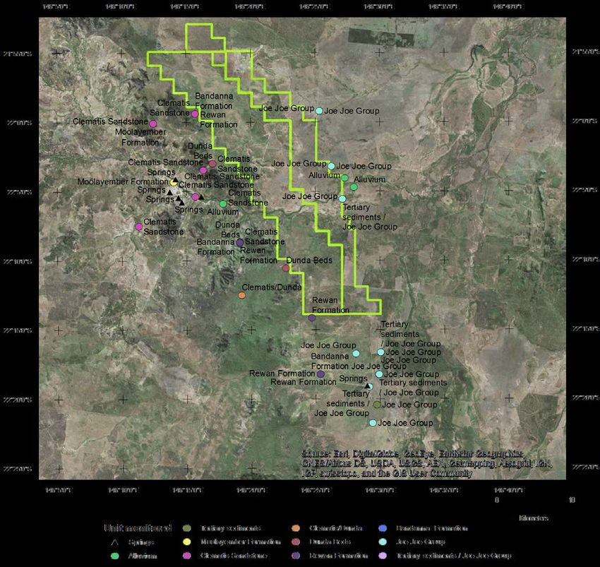
In the GMMP, there are 54 off-lease monitoring bores (Table 1 and Figure 1 below). The off-lease
monitoring bores are primarily designed to monitor the Joe Joe Group and the Clematis Sandstone.
These are the source aquifers proposed by the proponent for the Mellaluka Springs and DSC
respectively. The monitoring network set out in the GMMP for the Mellaluka Springs appears
1
adequate, given that these are sourced from the Joe Joe Group and Tertiary sediments.
Recommendation: Installation of bores to monitor the groundwater system in the Dunda Beds and
Rewan Formation (upper Rewan and lower Rewan) at existing monitoring points in the west of the
central zone would allow an assessment of any dewatering impact propagating through the Rewan
Formation (in effect, nested monitoring bores). The current monitoring network does not address any
contributions to the springs from the Dunda Beds or Rewan Formation, or from deeper units. These
potential spring contributions need to be considered and factored into monitoring design. Monitoring
these two units is considered a bare-minimum. Ideally all units from outcrop to sub-Joe Joe coal
(Jericho Formation) would be monitored. Co-location with existing points would remove any significant
access issues, and would enable at least spatially comparable data to be collected.
Recommendation: It is strongly recommended that the monitoring program includes stream flow
gauging upstream and downstream of the mine area. Stream gauging similar to that undertaken for
the EIS would address this, provided it is part of ongoing monitoring programmes. Stream flow is a
critical calibration parameter for the groundwater model. The current model is based on very limited
surface water monitoring data and the status of the gauges installed to acquire this data is unknown.
1
“Tertiary” is a non-standard term used by Adani, and so this use is continued throughout this advice. The standard terms
applied to the Geological Timescale are available from the International Commission on Stratigraphy
(http://www.stratigraphy.org/index.php/ics-chart-timescale).
Carmichael Coal Mine: Advice on Groundwater Management and Monitoring and Groundwater Dependent Ecosystem
Management plans to the Department of the Environment and Energy
D2019-19528 11Additionally, an improved and re-calibrated flow-discharge relationship for each gauge would improve the accuracy of the data. Baseflow conditions across the site varies, with the Carmichael River switching from gaining to losing and to gaining again, ongoing. Consequently gauging where the river enters and leaves the lease is necessary to better understand the interactions between surface water and groundwater, and the implications for the Carmichael River GDEs in this area. Gauging data would also address issues with stream flow identified in Section 2.3.1. Table 1 Number of off-lease monitoring bores by formation. Formation Number of bores Springs 7 Alluvium 3 Tertiary sediments 1 Moolayember Formation 2 Clematis Sandstone 10 Clematis/Dunda 1 Dunda Beds 3 Rewan Formation 5 Bandanna Formation 3 Joe Joe Group 15 Tertiary sediments / Joe Joe Group 4 Carmichael Coal Mine: Advice on Groundwater Management and Monitoring and Groundwater Dependent Ecosystem Management plans to the Department of the Environment and Energy D2019-19528 12
Figure 1. Spatial distribution of off-lease monitoring bores. Note that some locations represent nested bore sites.
The green polygon shows the Proponent’s mining lease areas.

3.4 Management approaches: water level thresholds and triggers
Issue: The use of drawdown rate triggers for the Rewan Formation and Dunda Beds (GMMP section
5.3.5.2) as part of the groundwater level monitoring and management regime represents a valid, well-
considered approach to adaptive management. This approach relies heavily on predicted impacts.
Bores C555P1 and C556P1, two of the three bores for which drawdown rate limits have been set, lie
within the underground mining footprint. These may be impacted directly by mining activity.

The Proponent presents predicted impact hydrographs based on modelling in Appendix E. The
hydrographs presented indicate that the bores listed in Table 2 will exceed nominated threshold levels.
These drawdowns are all attributable to "approved mining activities", and most of the Alluvium,
Tertiary, Clematis and Dunda bores will experience these exceedances within 40 years of
commencement of "approved mining activities”. The introduction of drawdown rate limits for selected
Rewan Formation and Dunda Beds bores represents a positive approach to adaptive management for
early warning of potential impacts. However, these limits do not address the concern that overall
groundwater level thresholds will be exceeded by a large number of bores.

Carmichael Coal Mine: Advice on Groundwater Management and Monitoring and Groundwater Dependent Ecosystem
Management plans to the Department of the Environment and Energy
D2019-19528                                                                                              13
Recommendation: All monitoring locations for which water level thresholds are defined should also
have drawdown rate limits derived. Evaluation of drawdown rate limits should form part of routine
monitoring data assessment and be included in the Impact Threshold Assessment approach outlined
in GMMP Section 5.3.5.3 and GMMP Plate 24.

Table 2 Monitoring bores identified as exceeding thresholds during operation

C022P1            C016P2             C025P1             C025P2                 C027P2      C029P1
C029P2            C555P1             C556P1             C558VWP1               C848SP      C851VWP2
C968VWP_P2        C968VWP_P5         C9553P1R           C9845SPR               C14004SP    C14006SP
C14008SP          C14011SP           C14012SP           C14013SP               C14015SP    C14016SP
C14020SP          C14021SP           C14023SP           C14024SP               C14028SP    C14029SP
C914030SPR        C14033SP           C14206VWP_1        C180116SP              C180117SP   C180118SP

Issue: The threshold proposed for C025P1 appears inappropriate. It will trigger immediately as the
bore has been reported dry for 4 years.

Recommendation: This bore should not be used as a threshold monitoring point until a deeper
replacement has been installed. The threshold for the new bore should only be set after the acquisition
of sufficient baseline data.

Issue: GMMP Section 5.3.3.1 and Section 5.3.5.1 indicate the processes by which a threshold will be
triggered and an investigation initiated, for bores across the monitoring network and early warning
trigger bores, respectively. Some of the actions presented are inconsistently applied or poorly defined.

Recommendation: To ensure clarity of management processes and that DoEE are aware that an
investigation report is being produced, the Proponent should explicitly state that the Commonwealth
regulator will be notified whenever a groundwater level exceedance occurs. The Proponent should
commit to a maximum timeframe in which the investigation will be completed (for example three
months) in the GMMP.

Issue: Quantification of non-mining influences on water levels (such as other land uses or climatic
variability) has proven to be a complex and contentious process for other projects.

Recommendation: It is recommended that the Proponent provide details of how this process will
occur during investigation of threshold exceedances, so that an agreed approach is in place before
any exceedances occur.

Issue: Mitigation actions are not presented in the GMMP, and a number of references are made to
actions presented in the GAB Spring Research Plan (GABSRP) or the Biodiversity Offset Strategy
(BOS, out of scope for this advice). CSIRO and Geoscience Australia (2018) provides comments
about the mitigation actions described in the GABSRP. EPBC Act approval condition 3.d) indicates
that mitigation measures to protect the DSC must be incorporated into the GMMP.

3.5 Management approaches: hydrogeochemical triggers and
thresholds
Groundwater quality is a key monitoring attribute for all GDEs in the GDEMP (Table 5-1) and
groundwater quality triggers will be used to assess potential impacts on GDEs. The Proponent has

Carmichael Coal Mine: Advice on Groundwater Management and Monitoring and Groundwater Dependent Ecosystem
Management plans to the Department of the Environment and Energy
D2019-19528                                                                                              14
established contaminant (groundwater quality) trigger levels and contaminant limits with the
Queensland Department of Environment and Science (DES). The trigger levels allow for investigation
and implementation of mitigation measures prior to reaching any groundwater quality limits.
Contaminant limits (presented in Appendix D of GMMP) will be used to assess the potential for
environmental harm, presumably resulting from a trigger exceedance. The GMMP states that triggers
and limits may be revised if they are exceeded due to natural conditions.

Issue: As was the case in previous versions of the GMMP, there are trigger levels for up to 38
analytes for bores and hydrostratigraphic units, based on the 85th percentile of background data where
more than 12 results are beyond the limit of laboratory detection. This is a sound approach, but does
mean trigger levels should be reached 15% of the time for each analyte.

Recommendation: Given the regularity with which exceedances are expected to occur, consideration
should be given to:

    •    the implication of frequent triggering,

    •    how these exceedances will be investigated,

    •    how the Proponent will be able to differentiate between a trigger that does not result in
         environmental harm and one that might,

    •    ensuring that frequently exceeded triggers do not result in the conclusion that it is always due
         to natural variability,

    •    how an investigation into the cause of the exceedance will be undertaken, such as how an
         exceedance will be evaluated as being due to natural variability or mining activities,

    •    providing a timeline of how long an investigation will take and what data the Proponent will
         need to undertake this investigation, such as groundwater use volumes by other users.

There have been some changes to trigger levels compared to previous versions following discussions
between the Proponent and the Queensland DES. There is now a “two consecutive exceedances
approach” to trigger values, such that an investigation will only be initiated after two consecutive
exceedances are detected. This is an appropriate approach. The “two consecutive exceedances
approach” results in approximately 6 months passing before an exceedance is identified, based on
groundwater monitoring events occurring every 3 months. The GMMP states that DoEE will not be
notified when an exceedance occurs; notification will only occur 28 days after completion of the
investigation into the cause of the exceedance. Given the length of time this may take (no time frame
is provided in the GMMP), DoEE may not be notified of an exceedance until many months after it was
first identified.

Recommendation: Consideration should be given to extending the approach to two exceedances
within 12 months (~4 sampling events) rather than just consecutive exceedances, to ensure triggers
can provide an early warning of potential impacts. The management actions would also be
strengthened by providing a maximum time frame for an investigation.

If the investigation finds that the exceedances are due to mining activities, the Proponent commits to
undertaking a further investigation to determine if ‘environmental harm’ has occurred. The GMMP
states that the contaminant limits are ‘for consideration’ when assessing the potential for
environmental harm, however it is not clear how they will be used or if they are enforceable limits.
There may also be a time lag between a trigger exceedance and the realisation of ‘environmental
harm’.

Carmichael Coal Mine: Advice on Groundwater Management and Monitoring and Groundwater Dependent Ecosystem
Management plans to the Department of the Environment and Energy
D2019-19528                                                                                              15
Issue: Table 45 in the GMMP describes the proposed trigger level methodology and step 4 states that
‘all trigger levels derived from the baseline monitoring program (at least eight results greater than
LOR) are compared to the ANZECC & ARMCANZ 2000 guideline values per analyte (95th protection
and low reliability). In instances where the ANZECC & ARMCANZ 2000 guideline value is higher, this
ANZECC value should be adopted as the proposed trigger level.’ In some cases, this results in trigger
levels far in excess of baseline conditions (e.g. manganese and boron in bores screened in the
Clematis Sandstone). This is contradictory to the principles of the Guidelines, which recommend that
the default guideline values are a generic starting point for assessing water quality and specify that
there is a distinct advantage in tailoring guideline values to reflect local conditions for the protection of
aquatic ecosystems. The triggers and limits appear to be based on data collected in April 2017.
Recommendation: A clear statement regarding whether triggers and limits will be updated when
additional pre-operational hydrochemistry data are collected should be included. Some bores may
then have the required number of analyses to calculate baseline trigger values at that point, which
would be preferable to using generic triggers derived from the ANZECC guidelines.
Issue: The GMMP and GDEMP state that the hydrochemistry triggers are interim for two years. This is
generally a good approach for adaptive management, however care will need to be taken to ensure
this does not result in triggers creeping up to avoid exceedances that will occur with the triggers set at
the 85th percentile of baseline.
Issue: Setting static trigger levels does not account for trends in hydrochemistry that may provide an
early indication of impact.
Recommendation: An assessment of trends in the hydrochemistry data following each monitoring
event will identify if groundwater quality is changing over time, which may provide an early warning of
triggers being approached.
Issue: The GMMP states that monitoring data will be verified and then reviewed on a regular basis
and reported to the regulators.
Recommendation: This should include an assessment of hydrochemistry at the site, in addition to
presenting raw data.
Issue: Detailed issues with the triggers and limits are as follows:
• The increased number of analytes that have a contaminant limit assigned to them compared to
previous versions (including aluminium, cadmium, chromium, lead, molybdenum, selenium, silver,
vanadium, mercury and nitrate) is an improvement over previous versions of the GMMP.
• Contaminant limits for "HD03A and C14021SP" and "All other Clematis bores" seem to have been
swapped between the current version of the GMMP and previous versions.
• In many cases, the trigger is the same as the contaminant limit or not substantially different (e.g.Issue: There are instances where the trigger level is higher than the contaminant level in bores
screened in the Alluvium and Clematis Sandstone. It is not clear how an investigation into an
exceedance would progress in this scenario.
In some cases, the contaminant limit is far in excess of the background conditions at the site. In
particular, the limits for boron, manganese and iron are consistently higher than baseline data.
Issue: For Clematis Sandstone bores, many dissolved metals have a no value (NV) contaminant limit.
This means that there are not contaminant limits defined for the Proponent’s preferred source aquifer
for the DSC.
Recommendation: Given that the Proponent considers the Clematis Sandstone as the sole source
aquifer for the DSC, contaminant limits for the Clematis Sandstone are required.
3.6 Ecological monitoring
The GDEMP sets out how to minimise and manage the environmental impacts of the Project on the
four groundwater-dependent ecosystems listed in the approval conditions, through the combination of
specific ecological measurements and links with other research and management plans (GMMP,
GABSRP, RFCRP, Receiving Environment Management Plan, BOS, Great Artesian Basin Offset
Strategy, Offset Area Management Plans, and MNES Plans). Proposed ecosystem measurements are
based on relevant research and management guidelines. However, limitations identified for other
management plans, in particular the GMMP, RFCRP and GAPSRP, mean that the proposed
groundwater monitoring approaches are not sufficiently robust to ensure the outcomes sought by the
conditions of approval are met.
The design of the ecological monitoring approach follows the GDE Toolbox approach and relevant
research and management plans, which is considered to be adequate for monitoring potential impacts
to GDEs. In the event that trigger levels are exceeded, the GDEMP will investigate the cause and
notify the administering authority within 28 days. If mining activities are identified as the cause, the
plan will revise monitoring and management approaches, including ecological and/or groundwater
triggers; relevant operational constraints to manage groundwater drawdown impacts, such as revised
mine planning or associated activities; changes to research priorities and additional mitigation and/or
offset measures.
The GDEMP systematically addresses the management objectives, performance criteria, adaptive
management triggers and corrective actions for each of the four GDEs identified in the approval
conditions:
• Waxy Cabbage Palm (Livistona lanuginosa)
• Carmichael River (Carmichael River and its riparian zone between the Doongmabulla springs
and the Belyando River)
• The Mellaluka Springs-complex
• Community of native species dependent on discharge from the Great Artesian Basin
(Doongmabulla Springs-complex) including the Salt Pipewort Eriocaulon carsonii; and the
Blue Devil Eryngium fontanum.
Carmichael Coal Mine: Advice on Groundwater Management and Monitoring and Groundwater Dependent Ecosystem
Management plans to the Department of the Environment and Energy
D2019-19528 17References
Adani (2019) Carmichael Coal Mine – Groundwater level review.
Adhikary DP and Poulsen BA (2018) Estimating the Height of Mining Induced Connective Fracturing.
52nd U.S. Rock Mechanics/Geomechanics Symposium. American Rock Mechanics
Association, ARMA, 7.
Australasian Groundwater and Environmental Consultants Pty Ltd (AGES) (2015) Report on Project
China Stone Groudwater Report. Prepared for Hansen Bailey.,
http://eisdocs.dsdip.qld.gov.au/China%20Stone%20Coal/DEIS/Draft%20EIS%20-
%20Volume%204/china-stone-appendix-i-groundwater-report.pdf.
Barnett B, Townley L, Post V, Evans R, Hunt R, Peeters L, Richardson S, Werner A, Knapton A and
Boronkay A (2012) Australian groundwater modelling guidelines. . National Water
Commission, Canberra.
Comet Ridge Limited (2015) COI 2015 seismic reprcessing project. Carmichael Prospect ATP744
Galilee Basin, Queensland. Reprocessing Rerport.,
https://www.business.qld.gov.au/industries/mining-energy-water/resources/minerals-
coal/online-services/qdex-reports.
CSIRO and Geoscience Australia (2018) Carmichael Coal Mine: Advice on draft research plans to the
Department of the Environment and Energy.
Currell MJ, Werner AD, McGrath C, Webb JA and Berkman M (2017) Problems with the application of
hydrogeological science to regulation of Australian mining projects: Carmichael Mine and
Doongmabulla Springs. Journal of Hydrology 548, 674-682. DOI:
https://doi.org/10.1016/j.jhydrol.2017.03.031.
Evans T, Kellett J, Ransley T, Harris-Pascal C, Radke B, Cassel R, Karim F, Hostetler S, Galinec V,
Dehelean A, Caruana L and Kilgour P (2018) Observations analysis, statistical analysis and
interpolation for the Galilee subregion. Product 2.1-2.2 for the Galilee subregion from the Lake
Eyre Basin Bioregional Assessment. Department of the Environment and Energy, Bureau of
Meteorology, CSIRO and Geoscience Australia, Australia.
http://data.bioregionalassessments.gov.au/product/LEB/GAL/2.1-2.2.
Fensham RJ, Silcock JL, Laffineur B and MacDermott HJ (2016) Lake Eyre Basin Springs
Assessment Project: Hydrogeology, cultural history and biological values of springs in the
Barcaldine, Springvale and Flinders River supergroups, Galilee Basin springs and Tertiary
springs of western Queensland. Queensland Department of Science, Information Technology
and Innovation, Brisbane. https://publications.qld.gov.au/dataset/lake-
eyre/resource/c5d1813b-73a4-4e05-aa86-39a8ed3045fb.
GHD (2013) Carmichael Coal mine and Rail Project SEIS Report for Mine Hydrogeology Report. 13
November 2013.,
http://eisdocs.dsdip.qld.gov.au/Carmichael%20Coal%20Mine%20and%20Rail/SEIS/Appendic
es/Appendix%20K/Appendix-K1-Mine-Hydrogeology-Report.pdf.
Independent Expert Scientific Committee on Coal Seam Gas and Large Coal Mining Development
(2013) Advice to decision maker on coal mining project. Proposed Action: Carmichael Coal
Mine and Rail Project, Queensland (EPBC 2010/5736) - New Development.
http://www.iesc.environment.gov.au/system/files/resources/224fbb59-e5e6-4154-9dd0-
8d60d7c87a75/files/iesc-advice-carmichael-2013-034.pdf.
JBT Consulting (2015) Further statement of evidence - geology and hydrogeology. Report dated 6
February 2015. http://envlaw.com.au/wp-content/uploads/carmichael8.pdf.
Land Court of Queensland (2015) Adani Mining Pty Ltd v Land Services of Coast and Country inc &
Ors. QLC 48.
Carmichael Coal Mine: Advice on Groundwater Management and Monitoring and Groundwater Dependent Ecosystem
Management plans to the Department of the Environment and Energy
D2019-19528 18Lewis S, Evans T, Pavey C, Holland KL, Henderson BL, Kilgour P, Dehelean A, Karim F, Viney NRP,
D A, Schmidt RK, Sudholz C, Brandon C, Zhang YQ, Lymburner L, Dunn B, Mount R,
Gonzalez D, Peeters LJM, O’ Grady A, Dunne R, Ickowicz A, Hosack G, Hayes KR,
Dambacher J and Barry S (2018) Impact and risk analysis for the Galilee subregion. Product
3-4 for the Galilee subregion from the Lake Eyre Basin Bioregional Assessment. Department
of the Environment and Energy, Bureau of Meteorology, CSIRO and Geoscience Australia,
Australia. http://data.bioregionalassessments.gov.au/product/LEB/GAL/3-4.
Mallants D, Underschultz J and Simmons C (eds) (2018) Integrated analysis of hydrochemical,
geophysical, hydraulic and structural geology data to improve characterisation and
conceptualisation of faults for use in regional groundwater flow models, prepared by the
Commonwealth Scientific and Industrial Research Organisation (CSIRO) in collaboration with
University of Queensland (UQ) and Flinders University of South Australia (FUSA).
http://www.environment.gov.au/system/files/resources/30995d76-9ad9-4486-8b8c-
5d147fdc1d9d/files/integrated-analysis-hydrochemical-geophysical-hydraulic-structural-
geology-data.pdf.
Middlemis H (2000) Murray-Darling Basin Commission: Groundwater flow modelling guide. Murray
Darling Basin Commission.
Middlemis H and Peeters LJM (2018) Uncertainty analysis—Guidance for groundwater modelling
within a risk management framework. A report prepared for the Independent Expert Scientific
Committee on Coal Seam Gas and Large Coal Mining Development through the Department
of the Environment and Energy, Commonwealth of Australia 2018. .
http://www.iesc.environment.gov.au/publications/information-guidelines-explanatory-note-
uncertainty-analysis.
Moya CE, Raiber M, Taulis M and Cox ME (2016) Using environmental isotopes and dissolved
methane concentrations to constrain hydrochemical processes and inter-aquifer mixing in the
Galilee and Eromanga Basins, Great Artesian Basin, Australia. Journal of Hydrology 539, 304-
318. DOI: https://doi.org/10.1016/j.jhydrol.2016.05.016.
Peeters L, Ransley T, Turnadge C, Kellett J, Harris-Pascal C, Kilgour P and Evans T (2018)
Groundwater numerical modelling for the Galilee subregion. Product 2.6.2 for the Galilee
subregion from the Lake Eyre Basin Bioregional Assessment. . Department of the
Environment and Energy, Bureau of Meteorology, CSIRO and Geoscience Australia,
Australia. http://data.bioregionalassessments.gov.au/product/LEB/GAL/2.6.2.
Poulsen BA, Adhikary D and Guo H (2018) Simulating mining-induced strata permeability changes.
Engineering Geology 237, 208-216. DOI: https://doi.org/10.1016/j.enggeo.2018.03.001.
QER Pty Ltd (2013) QERC-2011 2D Seismic survey ATP 984P, ATP 101P and ATP 1032P, Galilee
Basin, Queensland, final report. https://www.business.qld.gov.au/industries/mining-energy-
water/resources/minerals-coal/online-services/qdex-reports.
URS (2016) Carmichael Coal Project. Geological and groundwater assessement of the Rewan
Formation. Report prepared for Adani Mining Pty Ltd.
Velseis Processing Pty Ltd (2010) Data processing report. QER 2010 seismic reprocessing project,
Galilee Basin, Queensland. https://www.business.qld.gov.au/industries/mining-energy-
water/resources/minerals-coal/online-services/qdex-reports.
Webb J, Werner A, Bradley J and Merrick N (2015) First Groundwater Joint Expert Report to the Land
Court of Queensland. Report dated 9 January 2015. http://envlaw.com.au/wp-
content/uploads/carmichael7.pdf.
Webb JA (2015) Expert Report on groundwater impacts to the Land Court. Report dated 6 February
2015. http://envlaw.com.au/wp-content/uploads/carmichael9.pdf.
Carmichael Coal Mine: Advice on Groundwater Management and Monitoring and Groundwater Dependent Ecosystem
Management plans to the Department of the Environment and Energy
D2019-19528 19You can also read