Kingborough Council - KINGBOROUGH INTEGRATED TRANSPORT STRATEGY
←
→
Page content transcription
If your browser does not render page correctly, please read the page content below
Kingborough Council
21018152A
 MAY 2010

            KINGBOROUGH INTEGRATED TRANSPORT STRATEGY
Kingborough Integrated
                         Transport Strategy

                         May 2010

                         Kingborough Council

                         Parsons Brinckerhoff Australia Pty Limited
                         ABN 80 078 004 798

                         Level 15
                         28 Freshwater Place
                         SOUTHBANK VIC 3006
                         PO Box 19016
                         SOUTHBANK VIC 3006
                         Australia
                         Telephone    +61 3 9861 1111
                         Facsimile    +61 3 9861 1144
                         Email        melbourne@pb.com.au
21018152A-RPT-001-G KH   Certified to ISO 9001, ISO 14001, AS/NZS 4801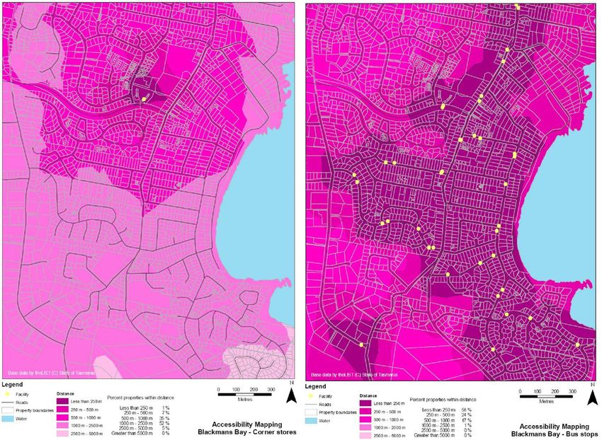
Revision        Details                                                                                      Date            Amended By
        00        Working Draft                                                                                December 2009
        01        Draft                                                                                        January 2010    KH
        02        Draft                                                                                        February 2010   KH
        03        Draft Final                                                                                  April 2010      KH
        04        Final                                                                                        May 2010        KH

©Parsons Brinckerhoff Australia Pty Limited (PB) [2010].
Copyright in the drawings, information and data recorded in this document (the information) is the property of PB. This document
and the information are solely for the use of the authorised recipient and this document may not be used, copied or reproduced in
whole or part for any purpose other than that for which it was supplied by PB. PB makes no representation, undertakes no duty and
accepts no responsibility to any third party who may use or rely upon this document or the information.
Author:         KLH (CN).........................................................................................

Reviewer:       EM ...................................................................................................

Approved by:    EM ...................................................................................................

Date:           May 2010 ........................................................................................

Distribution:   KCC .................................................................................................

21018152A-RPT-001-G KH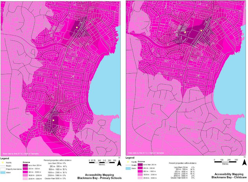
Kingborough Integrated Transport Strategy

Contents
                                                                                          Page number

Forward                                                                                                  iv

1.   The process                                                                                          1

2.   Vision                                                                                               2

     2.1   Vision for Kingborough 2020                                                                    2
     2.2   Vision for Kingborough’s transport in 2020                                                     2
     2.3   Strategic objectives                                                                           3

3.   Background                                                                                           4

     3.1   Existing policy framework                                                                      4
     3.2   Land use                                                                                       5
     3.3   Demographics                                                                                   5
     3.4   Transport                                                                                      8
     3.5   Kingston Central Area                                                                         13
           3.5.1    Parking                                                                              13
           3.5.2    Public transport                                                                     14
           3.5.3    Community transport                                                                  15
           3.5.4    Cycling and walking                                                                  16
     3.6   Accessibility                                                                                 17
     3.7   Climate change and peak oil                                                                   18
     3.8   Challenges                                                                                    19

4.   Principles and actions                                                                             20

     4.1   Land use and development                                                                      20
           4.1.1    Issues and recommendations raised by the community:                                  20
           4.1.2    Kingborough strategic objectives:                                                    21
           4.1.3    Principles:                                                                          21
           4.1.4    Actions:                                                                             21
           4.1.5    Summary                                                                              27
     4.2   Walking and cycling                                                                           29
           4.2.1     Issues and recommendations raised by community:                                     29
           4.2.2     Kingborough strategic objective:                                                    30
           4.2.3     Principles:                                                                         30
           4.2.4     Actions                                                                             30
           4.2.5     Summary                                                                             33
     4.3   Public transport                                                                              34
           4.3.1       Issues and recommendations raised by community:                                   34
           4.3.2       Kingborough strategic objectives                                                  35
           4.3.3       Principles:                                                                       35

PARSONS BRINCKERHOFF                   21018152A-RPT-001-G KH                                        Page i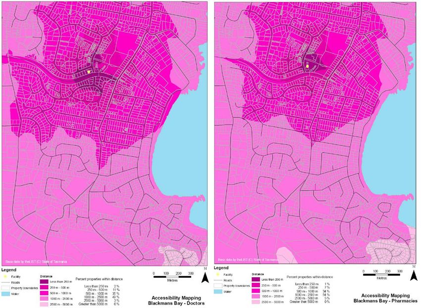
Kingborough Integrated Transport Strategy

            4.3.4   Actions                                                                                  35
            4.3.5   Summary                                                                                  40
      4.4   Road network                                                                                     42
            4.4.1   Issues and recommendations raised by community:                                          42
            4.4.2   Kingborough strategic objectives:                                                        43
            4.4.3   Principles:                                                                              43
            4.4.4   Actions                                                                                  43
            4.4.5   Summary                                                                                  47
      4.5   Promotion and education                                                                          48
            4.5.1     Issues and recommendations raised by community:                                        48
            4.5.2     Kingborough strategic objective:                                                       48
            4.5.3     Principles:                                                                            48
            4.5.4     Actions                                                                                48
            4.5.5     Summary                                                                                50

5.    Summary framework                                                                                     51

6.    Monitoring                                                                                            53

7.    Implementation plan                                                                                   55

      7.1   Regionally significant projects                                                                  55
      7.2   Locally significant planning projects                                                            56
      7.3   Locally significant promotion/education projects                                                 57
      7.4   Locally significant implementation projects and programs                                         58

8.    References                                                                                            59

List of tables
                                                                                              Page number

Table 3.1      Population of localities                                                                       7
Table 3.2      Method of travel to work by place of residence (ABS 2006)                                      8
Table 3.3      Greater Hobart traffic forecasts                                                              10
Table 3.4      Capacity and existing (2006) AADT                                                             11
Table 3.5      Estimated existing car parking                                                                14
Table 3.6      Percentage of residences within walking distance of bus stops                                 15
Table 4.1      Proposed Kingborough Activity Centre hierarchy                                                26
Table 4.2      Proposed premium bus stop locations                                                           36
Table 6.1      Measuring the KITS against the strategic objectives                                           54

PARSONS BRINCKERHOFF                    21018152A-RPT-001-G KH                                           Page ii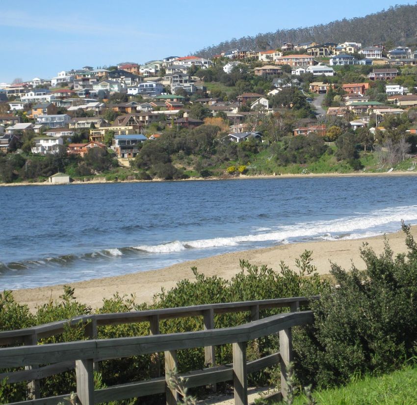
Kingborough Integrated Transport Strategy

List of figures
                                                                                       Page number

Figure 1.1    View from Kettering                                                                      1
Figure 3.1    Locality map                                                                             6
Figure 3.2    Kingborough population density                                                           7
Figure 3.3    Kingborough Road Hierarchy                                                               9
Figure 3.4    Daily traffic volumes                                                                   10
Figure 3.5    Kingston Bypass                                                                         12
Figure 3.6    Kingston Central Area preliminary road layout                                           13
Figure 3.7    Kingborough urban area (DIER) and Kingston Blackmans Bay Urban Centre (ABS)             14
Figure 3.8    Hobart Regional Arterial Bicycle Network                                                16
Figure 3.9    Kingborough cycle route network                                                         17
Figure 3.10   Milk map for Kingston – Corner Stores                                                   18
Figure 4.1    Potential park-and-ride sites for further investigation                                 24
Figure 4.2    View from Woodbridge                                                                    26
Figure 4.3    Kingston principal cycle network                                                        31
Figure 4.4    Kingborough principal regional cycle network                                            32
Figure 4.5    Bruny Island Ferry                                                                      37
Figure 4.6    Indicative future bus network                                                           39
Figure 4.7    Existing road conditions on Bruny Island                                                44
Figure 4.8    Indicative local road space management framework                                        45
Figure 4.9    Indicative Kingborough road space management framework                                  46
Figure 7.1    The Neck on Bruny Island                                                                58

Appendices
Appendix A Milk Maps
Appendix B Decision making framework

PARSONS BRINCKERHOFF               21018152A-RPT-001-G KH                                         Page iii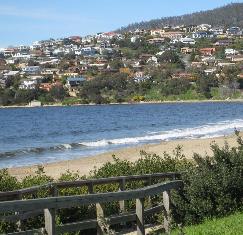
Kingborough Integrated Transport Strategy

Forward
Since the completion of the Southern Outlet in 1969 Kingborough has experienced continuous, rapid
growth, driven by lifestyle choice and affordable residential land close to the amenities of Hobart. A great
deal of new development has occurred and continues to occur within the municipality. It is expected that
this trend will continue into the future, putting pressure on existing transport infrastructure. This situation
could threaten Kingborough’s liveability, which is intrinsically linked to the surrounding environment.

There is a need to better plan for Kingborough’s future growth to protect and enhance the amenity for
local residents and visitors through better transport and land use integration. Transport and accessibility
issues have wide reaching impacts on the environmental, economic and social well-being of the
municipality. A sustainable transport approach is required that: manages travel demand; provides
efficient, effective and equitable transport options; limits environmental impact; and plans for future
communities.

The Kingborough Integrated Transport Strategy (KITS) will provide the necessary framework to guide
strategic outcomes that optimise the opportunities for increased accessibility across all relevant modes of
transport in Kingborough. It will support the development of essential and interrelated transport projects to
meet the needs of the community, and ensure necessary coordination from a transport and land use
planning perspective. Integral to the KITS are the broader environmental, social and economic objectives,
particularly regarding: climate change, healthy activity, community safety and liveability.

The KITS addresses community issues and strategic objectives through actions that focus on:

   regional planning
   decision making consistent with community values and vision
   behavioural change
   access to local services
   better bus services for urban and non urban areas
   improved walking and cycling infrastructure
   improved bus stop infrastructure
   safe and efficient transport
   parking management.

PARSONS BRINCKERHOFF                       21018152A-RPT-001-G KH                                           Page iv
Kingborough Integrated Transport Strategy

1.        The process
          The Kingborough Integrated Transport Strategy (KITS) was developed for the municipality of
          Kingborough in response to the need for a more coordinated and sustainable approach to
          transport issues. Development of the Strategy was based on the following process:

              Council held meetings with stakeholders and community representatives, regarding the
              scope of the Integrated Transport Strategy in 2008/2009

              consultants Parsons Brinckerhoff and Pitt & Sherry were commissioned to undertake
              the Kingborough Integrated Transport Strategy

              the consultants held meetings with stakeholders and community representatives
              regarding the vision and objectives for the KITS in late 2009

              the Draft KITS was presented to Council and the community in early 2010 for comment

              the Final KITS was developed based on the comments received on the draft

              the Final KITS was presented to Council in early 2010.

          Community consultation is a vital part of the integrated transport strategy development
          process. A summary of key issues raised through the community consultation process have
          been identified in the relevant sections as an effective check on whether the strategies and
          actions address the issues raised by the community.

          Figure 1.1      View from Kettering

PARSONS BRINCKERHOFF                 21018152A-RPT-001-G KH                                           Page 1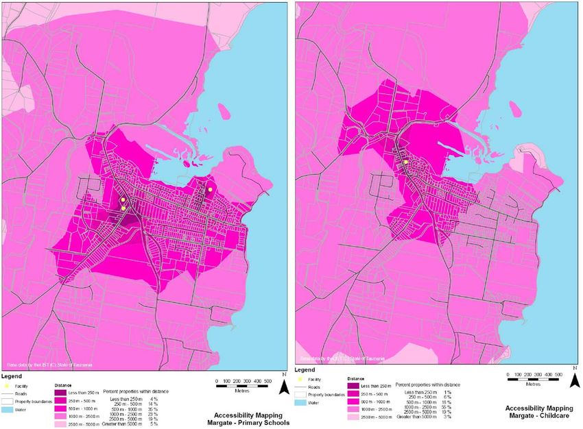
Kingborough Integrated Transport Strategy

2.        Vision
2.1       Vision for Kingborough 2020
          The Kingborough Strategic Plan 2010 – 2020 is an expression of the strategic directions for
          the Kingborough community, developed in accordance with the views of the community. The
          plan sets out the future directions and desired strategic outcomes for the Kingborough
          municipal area up to 2020, but does not include the detailed strategies and actions that will
          be required to achieve these outcomes.

           Kingborough Strategic Plan 2010 – 2020
           Vision          Kingborough in 2020 will be a:
                           thriving, vibrant and connected community
                           There is energy, passion and creativity in the way our community approaches its
                           social, economic and environmental challenges and opportunities. We are a
                           community which acknowledges respects and celebrates its diversity. We are
                           connected to each other and the rest of the world. Information technology helps
                           each household learn, communicate and engage locally and globally. We participate
                           in the life of our communities but are one community, encouraging all views.
                           healthy by nature
                           We have a healthy, active lifestyle sustained and supported by the nature that
                           surrounds us.
                           and naturally beautiful
                           Our land, coasts and waterways provide special places for recreation, relaxation and
                           reflection.
           Values          Sustainable
                           Honest and accountable
                           Open and inclusive
                           Caring and supportive
                           Strong leaders
                           Resilient and resourceful.
           Directions      1. Good governance
                           2. Managing and protecting our natural environment
                           3. Wellbeing and inclusiveness
                           4. Planning and managing growth
                           5. Integrated transport systems.

          The Kingborough Integrated Transport Strategy (KITS) forms part of a suite of strategic
          documents that will guide activities towards the implementation of the Strategic Plan. The
          KITS supports the future directions for Kingborough, consistent with the vision and values
          outlined in the Strategic Plan, in particular the future direction for integrated transport
          systems and underlying strategic objectives.

2.2       Vision for Kingborough’s transport in 2020
          The Vision for Kingborough, as set out in the Kingborough Draft Strategic Plan 2010 – 2020,
          is supported by the vision for Kingborough's transport system, which is based on safety,
          equity, accessibility, sustainability and behavioural change.

PARSONS BRINCKERHOFF                 21018152A-RPT-001-G KH                                               Page 2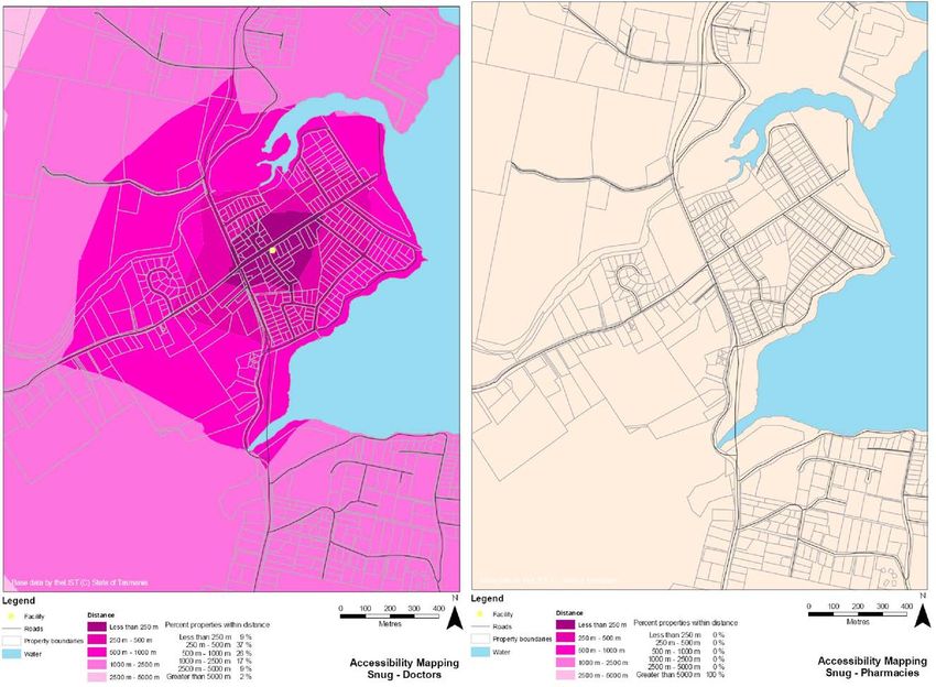
Kingborough Integrated Transport Strategy

                   From Taroona down to Gordon and including Bruny Island, Kingborough will be easy and
                   safe to get around, for all residents and visitors, through: better integration; infrastructure and
Safety, Equity &   services that support well connected communities; walkable neighbourhoods and town
  Accessibility    centres; strong regional links, especially to Hobart; and a focus on making the main regional
                   centre of Kingston accessible to the whole municipality, including those with mobility
                   restrictions such as young, old and less-abled people.

                   The high quality-of-life available in Kingborough, so intrinsically linked to the health of the
                   community, its economy and the environment, has led to Kingborough becoming one of the
  Sustainable
                   fastest growing municipalities in Tasmania. This character will be preserved through more
   Transport
                   sustainable transport. This will be achieved by reduced reliance on private motor vehicles;
                   convenient walking, cycling and public transport; options and reduced travel distances.

                   Working towards the vision will mean:

                        future developments in Kingborough will contribute to the improved accessibility and
                        sustainability of Kingborough

Travel Behaviour        improvements to existing transport infrastructure and services will focus on changing
    Change              travel behaviour

                        car dependency will be replaced with more sustainable transport use by removing
                        barriers and providing incentives for sustainable transport, through: better integration
                        between different modes; higher density and mixed land use centres; parking
                        management, greater priority for sustainable transport modes; and greater
                        communication of sustainable transport options.

   Defining key concepts for the vision
   Safety           Reduced transport accidents, safer spaces for vulnerable users and personal safety for active and
                    public transport.
   Equity           A fair distribution of services for all people of Kingborough.
   Accessibility    Convenient access to people, places, goods and services within an acceptable time and cost.
   Sustainable      Transport modes and practices that address current needs without compromising the ability for the
   transport        needs of future generations to be met, based on social, environmental and economic impacts, including
                    cycling, walking, public transport and reduced travel demand.
   Travel           Changes to individual everyday routines to adopt more sustainable travel behaviour, for example:
   Behaviour        reducing car based travel by shopping locally, walking or cycling or catching public transport, car
   change           pooling and multi purpose trips.

   2.3             Strategic objectives
                   Demonstrating consistency with the community’s values and vision, the KITS adopts the
                   strategic objectives for integrated transport systems identified in the Kingborough Strategic
                   Plan 2010 – 2020, as follows:

   Kingborough Strategic Plan – integrated transport systems - strategic objectives

       A reduced use/dependence on private motor vehicles through the encouragement of other forms of access and
       transport.
       An increased use of public transport that is convenient, accessible, safe and clean.
       An attractive and user friendly network of footpaths and trails for both pedestrians and cyclists.
       A community which is demonstrating increased use of park & walk and park & ride and car pooling opportunities.
       Efficient transport facilities servicing Bruny Island.

   PARSONS BRINCKERHOFF                            21018152A-RPT-001-G KH                                               Page 3
Kingborough Integrated Transport Strategy
3. Background
3.1 Existing policy framework
Existing policy documents, of particular relevance to the Kingborough Integrated Transport
Strategy (KITS), include:
Draft Southern Integrated Transport Plan, for public consultation, June 2009
Tasmanian Framework for Action on Climate Change, 2008
Hobart Regional Arterial Bicycle Network Final Draft, 2009
Kingborough Planning Scheme, 2000
Kingborough Bicycle Plan Final Draft, 2006
Kingston Central Area Master Plan Review, 2009
Kingborough Access Advisory Committee Action Plan
Tasmanian State Coastal Policy, 1996.
A common objective within the policies, specifically relevant to the KITS, is a reduced
dependence on private vehicles through the encouragement of other forms of access and
transport. Many of the relevant documents within the existing policy framework are currently
in draft format, reflecting the dynamic policy setting relating to transport and the environment.
Furthermore, following an agreement between the State Government, the Southern
Tasmanian Councils Authority (STCA), and the 12 southern Tasmanian Councils, a
comprehensive regional land use strategy and an infrastructure investment strategy for the
region are currently being prepared. This Integrated Transport Strategy will input into the
planning of these two important regional strategies.
Consistent with the Kingborough Access Advisory Committee Action Plan this strategy
assumes that, where practicable, physical infrastructure and developments in the
Kingborough area will be designed and constructed in a way that is accessible to residents
and visitors with a disability.
PARSONS BRINCKERHOFF 21018152A-RPT-001-G KH Page 4Kingborough Integrated Transport Strategy
3.2 Land use
The Municipality of Kingborough is situated on the south-east coast of Tasmania, just 10 km
south of Hobart. The municipality consists of mostly low density, residential land use located
within a natural setting along the Derwent Estuary and the D'Entrecasteaux Channel. Towns
in Kingborough include Kingston, Blackmans Bay, Margate, Snug, Kettering, Woodbridge
and Middleton, as shown in Figure 3.1. Taroona whilst not a town as such, is a built up urban
area which in effect operates as a suburb of both Hobart and Kingston. The municipality also
includes Bruny Island which lies just off the coast and can be reached by a car ferry from
Kettering.
Kingston is the major commercial, retail and administrative centre for the municipality. Local
industries include fish processing, aquaculture, tourism, viticulture, boat building, civil
engineering as well as the Australian headquarters for Antarctic Research. Kingborough is
also a major tourist destination, based on the natural attractions of Bruny Island and the
picturesque towns along the D’Entrecasteaux Channel.
Kingborough’s future growth areas will be identified in the revised Planning Scheme which is
currently being developed, however it is expected that the most significant growth will occur
in the Kingston/Blackmans Bay area around Huntingfield and Spring Farm. Limited growth is
also projected in Margate and Snug.
3.3 Demographics
The Demographic Change Advisory Council Tasmania identified that Kingborough, with a
population of 31,706 in 2006 was the 5th largest of the 29 Local Government Areas (LGAs)
in Tasmania. Based on current projections, the population in 2010 is probably closer to
33,500. Kingborough has been one of the fastest growing municipalities in Tasmania for the
last ten years. Over the period from 2001 to 2006, Kingborough’s population grew by 2,327
persons or 7.9 per cent, compared to State growth of 3.8 per cent. This growth was the
result of net migration of 1,341 persons and a difference between births and deaths of 986
persons. Kingborough’s population is projected to increase by around 8,500 by 2032, the
second highest population change in Tasmania.
Consistent with the rest of Australia, Kingborough’s population is ageing, with the proportion
over 65 increasing due to longer life expectancies. This trend is exacerbated by the in-
migration of older residents relative to the loss of younger working age people (and their
children). In 2006 Kingborough’s median age was 39 years, which was slightly higher than
the State average of 38.8 years (Demographic Change Advisory Council Tasmania).
The population breakdown for the different localities obtained from A Review of the
Kingborough Planning Scheme 2000 - Kingborough Settlement Strategy (September 2009)
is shown in Table 3.1. The table shows that the Kingston and Blackmans Bay urban area
constitutes about 55% of the total population. This is illustrated in the map of population
density shown in Figure 3.2 based on 2006 ABS data. Overall, the municipality has low
population density with local concentrations at Taroona, Kingston/Blackmans Bay, Margate
and Snug.
PARSONS BRINCKERHOFF 21018152A-RPT-001-G KH Page 5Kingborough Integrated Transport Strategy
Base map: 2009 Google - Maps
Figure 3.1 Locality map
PARSONS BRINCKERHOFF 21018152A-RPT-001-G KH Page 6Kingborough Integrated Transport Strategy
Table 3.1 Population of localities
LOCALITY POPULATION
Albion Heights – Ferntree – Huon Road 1,052
Taroona 3,064
Bonnett Hill 477
Kingston Beach and Heights 1,039
Kingston 8,674
Huntingfield 465
Kingston South – Summerleas Road 888
Blackmans Bay 6,510
Howden - Tinderbox 1,171
Margate (and surrounds) 1,908
Sandfly, Allens Rivulet 1,748
Baretta – Electrona 644
Snug – Coningham 1,095
Kettering – Oyster Cove (and surrounds) 1,100
Woodbridge (and surrounds) 656
Middleton – Gordon (and surrounds) 519
Bruny Island (north) 226
Bruny Island (south) 470
TOTAL 31,706
Source: A Review of the Kingborough Planning Scheme 2000 - Kingborough Settlement Strategy (2009)
Taroona
Kingston/
Blackmans Bay
Margate
Snug
People per sq km
Source: ABS 2006
Figure 3.2 Kingborough population density by collector district
PARSONS BRINCKERHOFF 21018152A-RPT-001-G KH Page 7Kingborough Integrated Transport Strategy
An existing benchmark for travel behaviour in Kingborough is provided by 2006 ABS travel to
work data shown in the table below. Travel to work in Kingborough is predominantly based
around the motor vehicle however bus travel, walking and working from home are relatively
popular sustainable travel options which could be expanded. It should be noted that 34
people (0.2%) drove a car and caught a bus, indicating the existing level of park-and-ride,
while 47 people (0.3%) were driven in a car and caught a bus, indicating the existing level of
kiss-and-ride.
Table 3.2 Method of travel to work by place of residence (ABS 2006)
Workers
Method of travel to work %
(Over 15)
Bus 598 4.1
Bus + other modes 87 0.6
Taxi 18 0.1
Car as driver 8,944 61.9
Truck 122 0.8
Car as passenger 1,122 7.8
Motorbike/scooter 63 0.4
Bicycle 99 0.7
Walked only 366 2.5
Worked at home 694 4.8
Did not go to work 1,904 13.2
Not stated 231 1.6
Other 198 1.4
14,446 100
3.4 Transport
The main transport corridors in Kingborough are the:
Southern Outlet – a dual carriageway linking Hobart and Kingston, which extends to
Southport as the Huon Highway
Channel Highway – the highway follows the coast between Hobart and Huonville
providing an alternative route between Kingston and Hobart, and a link to the
settlements in the south of Kingborough, as well as Taroona in the north
Huon Highway – the highway provides an east-west link between Kingston and
Huonville.
These roads form part of the state owned road network, as shown in Figure 3.3 (taken from
the Tasmanian State Road Hierarchy). The Tasmanian State Road Hierarchy furthermore
identifies the Southern Outlet and Huon Highway as the main freight route.
PARSONS BRINCKERHOFF 21018152A-RPT-001-G KH Page 8Kingborough Integrated Transport Strategy
Source: Tasmanian State Road Hierarchy
Figure 3.3 State Road Hierarchy surrounding Kingborough
Approximate average daily traffic volumes in Kingston are shown in Figure 3.4 (GHD, 2006
and 2008) and show the concentration of traffic on the Southern Outlet and Channel
Highway.
A summary of the expected growth rates for the Southern Outlet, Channel Highway and
Huon Highway, taken from the Southern Region Overview Report (2008) is shown in Table
3.3. The Channel Highway at Algona Road has relatively low traffic volumes but is
experiencing high levels of compound growth (consistent with population growth). The
reduced growth rate for traffic volumes on the Southern Outlet after 2011 assumes that that
development in the area will slow down by this time and that more of Kingborough’s
population would be living and working in the area rather than in the Hobart LGA.
The Southern Region Overview Report (2008) highlights traffic capacity issues on
Kingborough’s main road network. Table 3.4 lists the links identified within Kingborough
which will reach a level of service (LOS) D within 25 years. The Channel Highway is already
below this LOS, but the Kingston Bypass is designed to address this issue. Capacity issues
on the Southern Outlet could impact on public transport services between Hobart and
Kingston.
The Southern Region Overview Report (2008) identified relatively high safety risks on the
Channel Highway, between Taroona and Kingston, and between Cygnet and Oyster Cove
as well as on the Huon Highway between Huonville and Firthside (near Kingston).
PARSONS BRINCKERHOFF 21018152A-RPT-001-G KH Page 9Kingborough Integrated Transport Strategy
31,500 vpd
Huon Hwy 8,400 vpd (6.9%)
8,000 vpd
Freeman St 5,400 vpd (1.5%)
Channel Hwy 18,500 vpd (4.3%)
Church St 3,400 vpd (2.9%)
Church St 4,800 vpd (2.3%)
Denison St 3,900 vpd (-%)
Maranoa Rd 2,900 vpd (2.1%)
6,300 vpd
16,500vpd
2,300vpd
6,700 vpd
7,300 vpd
Sources:
GHD (2008) (% heavy vehicles)
GHD (2006)
Base map: 2009 Google - Maps
Figure 3.4 Daily traffic volumes
Table 3.3 Greater Hobart traffic forecasts
Location Compound traffic growth Traffic forecasts
per annum AADT
2005 2031
Southern Outlet South of Olinda Grove 1.50% to 2011; reducing to 32,000 42,500
1.13% until 2031
Channel Highway South of Algona Road 1.56% 11,800 18,600
Channel Highway at Lower Snug 1.31% 4,000 6,000
Huon Highway at Grove 1.57% 7,000 12,000
Source: Southern Region Overview Report (2008)
PARSONS BRINCKERHOFF 21018152A-RPT-001-G KH Page 10Kingborough Integrated Transport Strategy
Table 3.4 Capacity and existing (2006) AADT
Road name descriptor Estimated One-way Highway Years
2006 service capacity Remaining
AADT flow vph (two-way) at LOS D
vpd
Channel Hwy Interchange 13,000 1,299 11,800 Already
Sandfly Rd to Overpass
below LOS-
Kingston
D
Southern Outlet Channel 29,810 2,730 35,500 12
Hwy Highway to
Davey St
Huon Hwy Sandfly Rd to 7,240 1,080 9,800 20
Kingston
Interchange
Overpass
Algona MR Roslyn Ave to 6,490 1,298 11,800 24
Channel Hwy
Source: Southern Region Overview Report (2008)
Kingston Bypass
The intersection of the Southern Outlet/Huon Highway and Channel Highway at the Kingston
Central Area creates access issues for local and regional traffic. The Kingston and Environs
Transport Study (2006) identified the following main traffic issues:
travel delays on the Channel Highway
unnecessary through traffic (“rat-runs”) along Maranoa Road and Roslyn Avenue
access issues from driveways and side roads along the Channel Highway
access from Summerleas Road to the Channel Highway.
To address these issues DIER is tendering the construction of the Kingston Bypass, which
has been approved and is shown in Figure 3.5.
The project consists of:
a two-lane roadway with provision for a future dual carriageway
Summerleas Road interchange ramps
a roundabout at Algona Road to facilitate a future upgrade to an interchange and
improved access to Huntingfield
upgrade of Spring Farm Road for a future connection to Kingston View Drive
extension of the pedestrian underpass near Kingston High School
an Algona Road pedestrian underpass
reinstatement of the shared path and footpath on Summerleas Road
a new shared path on Spring Farm Road
PARSONS BRINCKERHOFF 21018152A-RPT-001-G KH Page 11Kingborough Integrated Transport Strategy
on-road cycle lanes at the Algona Road roundabout
extension of the Whitewater Creek recreation trail.
Source: DIER 2009
Source: DIER 2009
Figure 3.5 Kingston Bypass Project
PARSONS BRINCKERHOFF 21018152A-RPT-001-G KH Page 12Kingborough Integrated Transport Strategy
While the main benefits of the bypass are reduced congestion and improved traffic flow, it is
understood that the bypass will also facilitate future developments in the area, including the
further expansion of the Catholic secondary school, housing development at Huntingfield,
the relocation of Kingston High School and the Kingborough Sports Centre expansion. It will
also facilitate the improved use and amenity of the bypassed section of Channel Highway.
3.5 Kingston Central Area
The State Government’s decision to relocate the Kingston High School potentially releases a
large area of land within the Kingston Central Area providing opportunities for changes in
land use for commercial, community, residential and open space activities. The Kingston
Central Area Master Plan was updated to capitalise on this land release by providing Council
with a framework within which future development can be guided and subsequently
controlled. The Kingston Central Area Master Plan Review (2009) proposes a new road
network, shown in Figure 3.6 below and identifies that traffic modelling results indicate that
the revised road system will operate satisfactorily under forecasted traffic conditions up to
2017.
The specific development that is to occur on the school site is yet to be determined.
However, the Master Plan provides a framework within which development can occur. The
revised Master Plan identifies that the core retail area is to be focussed on the Channel
Highway. This will facilitate the upgrade and redevelopment of the Channel Highway by
Council, thereby maximising the streetscape amenity and actively discouraging traffic from
using the Channel Highway in preference to other routes.
John St
Beach Rd
Channel Hwy
Church St
Source: Kingston Central Area Master Plan
Figure 3.6 Kingston Central Area preliminary road layout
3.5.1 Parking
There is a common perception in the community that that the parking facilities in
Kingborough are inadequate, specifically in Kingston CBD, Kingston Beach, Margate and the
future Sports Centre/High School. An estimate of car parking supply is shown in the table
PARSONS BRINCKERHOFF 21018152A-RPT-001-G KH Page 13Kingborough Integrated Transport Strategy
below. Existing parking is free but many areas have time limits, predominantly two hour
parking, and council parking inspectors enforce this limit.
Table 3.5 Estimated existing car parking
Parking Total On Off Off street includes Note
street street
Blackmans Bay 170 40 130
Kingston 350 60 310 130 Foreshore/ 75 Council
Beach car park/85 hotel
Kingston Town 350 Predominantly Woolworths
Kingston CBD 1,700 450 1,250 700 Channel Court/ 200 Additional 1,000
Hotel/ 90 Council car park/ spaces will be
170 Kingston Plaza provided as part
(Coles)/ 40 medical centre/ of Channel Court
20 health centre Stage 2
Margate 150 150 80 Hotel
3.5.2 Public transport
Buses are the principal form of public transport in Kingborough. Metro Tasmania – a state
owned company – is contracted by DIER to operate core bus passenger services in the
area. The level of service varies greatly in the municipality, based on differences in
population levels between north and south. Taroona, Kingston and Blackmans Bay in the
north are included in the Greater Hobart urban bus network and therefore have higher
service levels than the remainder of the municipality, which is considered urban fringe.
Figure 3.7 shows the urban area map for Kingborough (DIER 2008) which goes as far south
as Huntingfield. DIER’s Review of the Core Passenger Services (2007) excluded Margate
and Snug from the urban area based on distances greater than 5km from the primary urban
centre boundary. The Kingston and Blackmans Bay Urban Centre is shown in Figure 3.7.
Source: ABS maps 2009 Kingston and
Source DIER 2008
Blackmans Bay Urban Centre Population Density
Figure 3.7 Kingborough urban area (DIER) and Kingston Blackmans Bay Urban
Centre (ABS))
PARSONS BRINCKERHOFF 21018152A-RPT-001-G KH Page 14Kingborough Integrated Transport Strategy
A 15 minute car ferry service between Bruny Island and Kettering also forms an important
part of the public transport network. The service runs approximately hourly between 7am and
7pm, with a limited number of bus connections to Kingston and Hobart.
Metro regards Kingston and Blackmans Bay as the fastest public transport growth area in
Tasmania following recent upgrades to services which have led to a significant increase in
patronage. Operating between 6am and midnight on weekdays, the Taroona - Kingston -
Blackmans Bay service is concentrated on high frequency bus corridors. The Kingston –
Hobart corridor runs 14 buses per hour in the peak (including Channel services). However
the service is made up of 13 routes, including large one way loops, with highly variable
headways sometimes ranging up to 60 minutes. On Saturdays generally four buses per hour
run between Kingston and Hobart from approximately 7am to 1:30am but specific routes run
approximately hourly. On Sundays buses operate hourly between 7:30am and 8:30pm.
Timetables and maps have recently been improved but there is still scope for further
simplification of information to current and potential passengers. Easy to use timetables
would help to make the services between Kingston and Hobart more accessible to new
users.
The Channel - Margate - Snug - Kettering - Woodbridge - Middleton - Gordon - Cygnet bus
service consists of nine routes which operate approximately between 7am and 7pm during
weekdays. Service levels for different towns range from one service to approximately 10
services each way per day to Gordon and Margate Central respectively. The majority of
routes have variations, some of which operate once a week, only during the school term or
school holidays. Weekend services are limited to only two services on Saturday but only go
as far south as Snug.
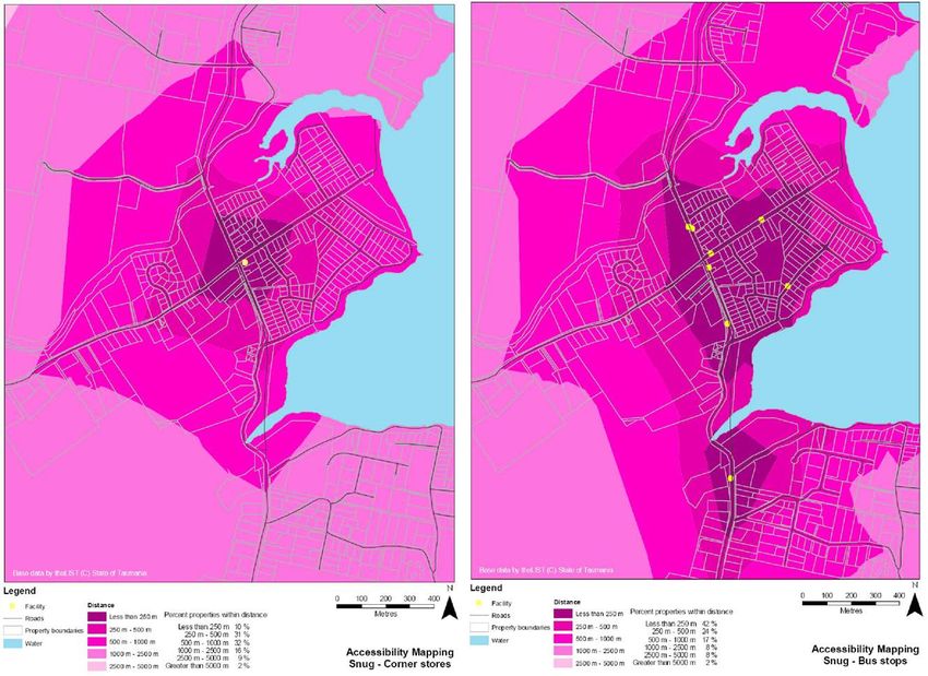
Bus stop accessibility and amenity is an important part of public transport. DIER’s urban
service standards identify a service level objective that 90% of residences should be within
500m of a bus route. Based on milk maps for Taroona, Kingston, Blackmans Bay, Margate
and Snug shown in Appendix A and summarised in the table below, only Taroona has 90%
of residences within 500m of bus stops. However Taroona, Blackmans Bay and Kingston
have 95 – 100% of residences within 1,000m of bus stops. Margate and Snug although
admittedly non-urban, have less then 70% of residences within 500m of bus stops, despite
diversions off the main route.
Table 3.6 Percentage of residences within walking distance of bus stops
% within 500m % within 1,000m
Taroona 92% 100%
Kingston 79% 95%
Blackmans Bay 82% 99%
Margate 47% 59%
Snug 66% 83%
3.5.3 Community transport
The Home and Community Care (HACC) Program provides community care services to
aged people and younger people with disabilities, and their carers. HACC funded community
transport, which operates throughout Kingborough (including Bruny Island), is primarily
aimed at assisting eligible transport disadvantaged people with travel for shopping and
appointments, and may include travel for social activities.
PARSONS BRINCKERHOFF 21018152A-RPT-001-G KH Page 15Kingborough Integrated Transport Strategy
3.5.4 Cycling and walking
Walking and cycling networks in Kingborough, include:
32 recreational walking tracks, with details readily available on Council’s website,
developed as part of the Tracks and Trails Program
the Hobart Regional Arterial Bicycle Network, shown in Figure 3.8
the Kingborough cycle route network, shown in Figure 3.9 taken from the Kingborough
Cycle Plan.
Both cycle network plans identify proposed cycle routes for future funding. A general walking
strategy has not been developed for Kingborough.
Source: Hobart Regional Arterial Bicycle Network 2009
Figure 3.8 Hobart Regional Arterial Bicycle Network
PARSONS BRINCKERHOFF 21018152A-RPT-001-G KH Page 16Kingborough Integrated Transport Strategy
Source: Kingborough Cycle Plan
Figure 3.9 Kingborough cycle route network
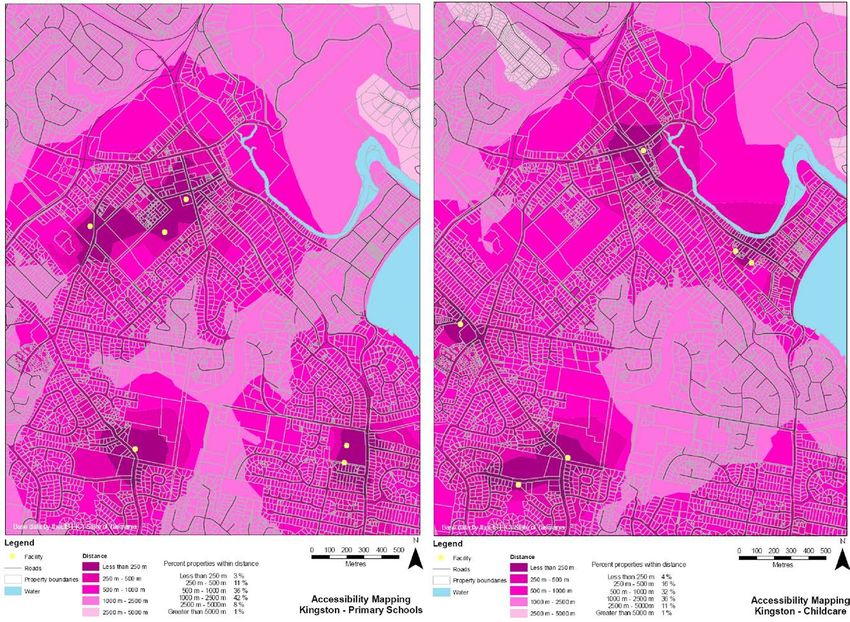
3.6 Accessibility
Accessibility is a function of land use and transport integration which can be illustrated
through milk maps, as demonstrated in the Southern Region Background Report (2007). Milk
maps measure accessibility for different areas by identifying the percentage of household
travelling within certain travel distance bandwidths to access essential services (originally a
litre of milk) Milk maps, shown in Appendix A, were created for Taroona, Kingston,
Blackmans Bay, Margate and Snug and show relative accessibility to:
general food store
doctor
pharmacy
PARSONS BRINCKERHOFF 21018152A-RPT-001-G KH Page 17Kingborough Integrated Transport Strategy
child care centre
primary schools.
In general, the majority of residences within the five areas examined were over a kilometre
from essential services. Without a strong public transport network this creates a strong
dependence on private motor vehicles. Snug, Taroona and Margate were missing some
local services, meaning longer distances to reach child care, food store, pharmacies and the
doctors in adjacent towns. With regard to Kingston and Blackmans Bay, services are
concentrated around the edges of the Kingston area and at Blackmans Bay shopping centre.
A sample milk map for Kingston is shown in Figure 3.10.
The KITS will support improved accessibility in Kingborough through more proactive
provisions in the Planning Scheme for new developments with regard to vehicle circulation
and cycle and pedestrian access. It will also support local services close to existing and
future residential areas.
Figure 3.10 Milk map for Kingston – Corner Stores
3.7 Climate change and peak oil
The Copenhagen Accord (2009) recognises climate change as one of the greatest
challenges of our time. To stabilise greenhouse gas concentration in the atmosphere at a
level that will prevent dangerous interference with the climate system, it was agreed that
deep cuts in global emissions are required.
PARSONS BRINCKERHOFF 21018152A-RPT-001-G KH Page 18Kingborough Integrated Transport Strategy
The Tasmanian Framework for Action on Climate Change, (2008) addresses the challenge
for Tasmania, to reduce greenhouse gas emissions while growing the economy and
improving quality of life. The framework identifies the target of reducing Tasmania’s
greenhouse emissions to at least 60 per cent below 1990 levels by 2050. One of the priority
areas for action is improving Tasmania’s transport system. New strategies are required to
encourage more walking, cycling and public transport. Tasmanian communities are also
required to be resilient and adaptive, in response to the challenge of climate change.
Peak oil is also a significant environmental issue which could severely affect our future
mobility. Our dependence on finite fossil fuels as an energy source for transport makes us
vulnerable to rising prices and the reduced availability of petrol.
The KITS will support Kingborough’s resilience to climate change and peak oil. In
accordance with the state objective, the KITS identifies local initiatives to encourage cycling,
walking, and public transport and supports local living as a means of reducing car
dependency and travel distances and thus greenhouse gases. The KITS also recognises the
importance of maintaining an efficient and effective road network in Kingborough, which will
support sustainable transport, including fuel efficient vehicles for the future. The KITS also
supports an adaptive response to climate change by identifying a flexible decision making
framework which can respond to new discoveries and innovations with regard to these and
other issues.
3.8 Challenges
Based on analysis of baseline conditions and consultation, the KITS will need to contribute to
the following:
a vision for the future
flexibility to respond to evolving issues
strategic regional policy and planning
protection of Kingborough’s natural setting and liveability, including impacts from climate change
local living to support the vitality of the area and reduce travel demand and infrastructure
requirements
behavioural change to reduce dependence on private vehicles
supporting Kingston as the heart of the municipality, including high quality amenities and
accessibility
integrated land use and intermodal transport planning, including provision for sustainable
development
higher urban densities to facilitate walking, cycling and public transport use
improved accessibility for walking and cycling
better public transport and community transport
safeguarding accessibility to Kingston and Hobart, by suitable modes
maintenance of the road network
accessibility and mobility for existing low density, dispersed settlements, particularly in the south
management of regional and local traffic, particularly within Kingston Central Area
funding for improved infrastructure, information and passenger transport services
accessibility for elderly and disabled people.
PARSONS BRINCKERHOFF 21018152A-RPT-001-G KH Page 19Kingborough Integrated Transport Strategy
4. Principles and actions
4.1 Land use and development
The municipality’s land use planning objectives are a prime driver for transport policy and the
future construction of transport infrastructure. Likewise transport issues must inform the
Planning Scheme and development approval process to protect amenity and sustainability.
Kingborough’s settlement patterns are characterised by low density and dispersed land
uses, along with established subdivisions with poor connectivity. This settlement pattern
supports the wide spread use of the private vehicles and reduces the convenience of more
sustainable travel options.
A key outcome of integrated land use and transport planning is to reduce private vehicle
travel demand. This can be achieved by: locating activities close to residents; supporting
higher density, mixed land use; encouraging growth near existing transport infrastructure and
services; encouraging people to work from home for example through improved internet
connections; and also through parking management.
4.1.1 Issues and recommendations raised by the community:
integrated transport needs to be examined across the region
conditions are needed on development permits requiring strategic links between open
spaces and subdivisions to be constructed
higher density development and provision of local services needs to be included in the
Planning Scheme
a parking strategy is needed for Kingston and Kingborough as a whole
park-and-ride is challenged by the convenience of travel from Kingston and
Kingborough to Hobart
park-and-ride at Margate is a better location than Kingston as it brings scattered
communities together in one spot for a bus to then collect them
park-and-ride needs to be examined on a Hobart wide basis
park-and-ride in Kingston needs to be relatively close to Kingston Central
a Travel Plan for the new Kingston High School is needed
need to ensure local facilities, such as a local shop, are provided near the Kingston
High School
need case by case examination of subdivision applications to ensure appropriate
footpaths will be provided
planning scheme needs to protect green space/farming land surrounding Margate and
control urban growth
parking issues in Margate
PARSONS BRINCKERHOFF 21018152A-RPT-001-G KH Page 20Kingborough Integrated Transport Strategy
propose a park-and-ride site at the Fork-In-The-Road at Huntingfield, which has the
advantage of being located at shops.
4.1.2 Kingborough strategic objectives:
a reduced use/dependence on private motor vehicles through the encouragement of
other forms of access and transport
a community which is demonstrating increased use of park-and-walk and park-and-ride
and car pooling opportunities.
4.1.3 Principles:
sustainable transport and accessibility will be supported through integrated land use
and transport planning at the regional and local level
mixed use activity centres will concentrate key attractors such as employment and
retail, as well as greater housing densities and will operate as transport choice hubs
urban growth will be concentrated in areas where sustainable transport options can be
provided most effectively and efficiently i.e. within or directly adjacent to the
Kingborough urban area as identified by DIER in relation to bus service planning
parking will be managed to support sustainable transport
new developments will be required to contribute to a safe attractive and comfortable
pedestrian, cycling and public transport environment, as well as an efficient and
effective road network.
4.1.4 Actions:
The issues and strategic objectives will be addressed through the following actions which
focus on regional planning, parking for sustainable development and land use that supports
local living.
Support regional planning:
provide input into the development of the regional land use strategy and infrastructure
investment strategy
provide input into development of the Greater Hobart Parking Strategy, identified as part
of the Draft Southern Integrated Transport Plan
identify urban growth boundaries for Kingborough, for input into a clear urban growth
boundary for the Greater Hobart area
undertake community visioning and scenario workshop/s with the purpose of future
proofing Kingborough’s land use and transport network.
Parking management for sustainable development:
Adopt a parking strategy for Kingborough, with the following aims and principles:
parking strategy aims:
PARSONS BRINCKERHOFF 21018152A-RPT-001-G KH Page 21Kingborough Integrated Transport Strategy
– improve accessibility, specifically in Kingston Central Area, Kingston Beach,
Margate and the new Sports Centre/Kingston High School site
– minimise negative impacts on sensitive land use, such as activity centres and
residential areas
– manage parking demand by encouraging sustainable transport
parking strategy principles:
– support shared public parking (park-and-walk) in preference to single user
parking, to minimise overall parking requirements
– restrict parking close to activities and services to short stay parking, to support
accessibility
– relocate staff and other all day parking from highly productive land, to sites
with good vehicle and pedestrian access
– adopt residential parking permit systems adjacent to high parking demand
areas
– establish developer contributions/annual levies to support public parking and
sustainable transport, with opportunity for developers to suggest and or deliver
appropriate infrastructure
– introduce parking charges incrementally at sensitive and high demand
locations: to help manage parking demand; encourage sustainable transport;
and fund parking facilities and improvements to public transport
– require convenient cycle parking
– support convenient park-and-ride and kiss-and-ride for residents with poor
access to public transport to shorten distances travelled by private vehicles. A
summary of desirable features and amenities for park-and-ride sites (which
would also include provision for kiss-and-ride) are listed below. A map
showing possible park-and-ride locations for further investigation is shown
overleaf.
Desirable features for park-and-ride site location
adequate parking spaces ideally with some provision for expansion
reliable and high frequency bus corridor (either as part of the existing network or stand alone)
easy access from areas with poor public transport
maintain central bus stops and direct bus routes, avoiding diversions and double-backs
reduce traffic congestion through direct access to the arterial road network
good pedestrian access to bus stops and any nearby activities
a management strategy, including: signage, monitoring and enforcement, as well as parking
management for the surrounding area
high amenity and security including: lighting, paving, shelter, information and passive
surveillance i.e. high visibility from adjacent roads
minimise impacts on highly productive or sensitive land use.
PARSONS BRINCKERHOFF 21018152A-RPT-001-G KH Page 22Kingborough Integrated Transport Strategy
Desirable amenities for park-and-ride facilities
shelter, seating, security and lighting
easy access to parking and drop off zone for kiss-and-ride
timetable information
convenient and secure bicycle parking to support bike-and-ride
rubbish bin
signage to closest toilets, phone, drinking fountains and parent facilities
community notice board
landscaping
branding and marketing including: directional signs from main roads, signage at the site and
maps of all sites. Marketing could also include a complementary breakfast
Develop a parking plan for Kingborough based on the parking strategy aims and
principles, to identify:
spatial distribution of existing and long term parking demand based on surveys and
projected land use
short and long term parking supply for visitors, loading, disabled persons, bicycles,
motorcycles, staff, commuter and residential parking, including identification of
available land for off-street parking, kiss-and-ride, park-and-ride facilities and
recommendations for multi-story options
parking restrictions and incremental staging for parking charges
appropriate incentives for fuel efficient vehicles, for example reduced parking
charges for electric vehicles
pedestrian, cycle and vehicle access to parking
appropriate parking rates for urban and non urban developments, including
applicability of maximum parking rates
developer contribution scheme
parking amenities and security.
Based on the recommendations from the parking plan and in consultation with Metro
and DIER, trial suitable park-and-ride sites, with priority for facilities at Huntingfield.
PARSONS BRINCKERHOFF 21018152A-RPT-001-G KH Page 23Kingborough Integrated Transport Strategy
Kingston Wetlands
(buses one way: 14 peak hr, 85 daily)
- Existing high frequency corridor
- May delay existing bus services
- Serves eastern residential area and
access also available from freeway
interchange
Denison Street: (buses one way: 4
- Need to manage any traffic congestion
peak hr, 36 daily)
Risk diverting people from local buses to
- Existing all day parking currently being
park-and-ride
used for park-&-ride and park-&-walk
Sports Centre (buses one way: 3 peak hr, 17 daily)
- Bus service would also support key attractors
- Need to manage any traffic congestion
Kingston Town Centre (buses one way: 4 peak hr, 36 daily)
- Access to amenities
- Further investigation needed to establish parking availability
Kingston Beach (buses one
way: 4 peak hr, 29 daily)
- Serves eastern residential
Huntingfield (buses one way: 5 peak hr, 15 daily)
area
- Convenient access from Channel towns
- Need to manage any traffic
- Bus services for Channel and Antarctic Division
congestion
- Boundary for urban bus services and fares
- Existing parking pressures
- Increased services would benefit growth area residents
- Opportunities with construction of bypass
Margate (buses one way: 5 peak hr, 10 daily)
- Convenient access from Channel towns
- Reduces vehicles to Kingston
- Supports Margate commercial centre
- Requires service level upgrade and cheaper fares
- A higher frequency bus service would benefit
Woodbridge (buses one way: 3 peak hr, 6 daily)
(Not shown) Need for all day parking near bus stop
Figure 4.1 Potential park-and-ride sites for further investigation
City of Glenorchy
Glenorchy City Council has developed a Commercial Precincts Car Parking Strategy which
considers: incremental introduction of parking charges for long stay parking, parking levies for
businesses, cash in lieu of parking and determination of reduced parking requirements based on
parking profiles rather than peak generation of individual uses. A parking profile provides a
temporal distribution of parking generation, which is useful in assessing developments with peak
parking demand outside shopping centre peaks.
PARSONS BRINCKERHOFF 21018152A-RPT-001-G KH Page 24Kingborough Integrated Transport Strategy
City of Hobart
Hobart City Council’s Sustainable Transport Strategy makes provision for development of a long
term car parking strategy for the Hobart CBD with a goal of managing parking supply to promote
and support sustainable transport, including:
no net increase of available parking
fee reforms in Council’s car parks to discourage commuter use
parking fee reforms which favour smaller, fuel efficient vehicles.
Support local living:
add proactive provisions in the Planning Scheme for new developments with regard to
requirements for:
cycle and pedestrian access, connectivity, parking, standards and widths
vehicle circulation
community transport access, turning circles and pavement strengths. This is in
addition to the current provisions for public transport
make the following provisions in the Planning Scheme (consistent with the Planning
Scheme Review):
Desired Future Character Statements supporting:
– concentration of main residential growth in the urban centre of
Kingston/Blackmans Bay
– higher density development close to activity centres
– further commercial development in Kingston and Margate central areas, as
well as redevelopment of the Taroona Shopping Centre
– support basic local services such as a general store/pharmacy and child care
close to existing and future residential areas
identification of urban growth boundaries in Kingborough to concentrate demand
for transport services
prioritise sustainable transport infrastructure improvements for key activity centres. Key
activity centres are proposed in Table 4.1 based upon the location of higher density
residential developments, aged care and major attractors, as set out in the Planning
Scheme Review’s revised Desired Future Character Statements. Infrastructure
improvements are proposed to include:
lighting
bus stop shelter for protection from the sun, rain and wind
seating
rubbish bins
signage, timetables and relevant information for tourists and new users
walking and cycling access, including paths and kerb ramps
provision for people with mobility restrictions, including appropriate clearances for
pedestrians and kerb heights for bus stop accessibility
convenient cycle parking/lockers and drinking fountains
PARSONS BRINCKERHOFF 21018152A-RPT-001-G KH Page 25Kingborough Integrated Transport Strategy
access to change room facilities/showers/toilets/personal lockers where feasible
and appropriate
require major developments to provide Green Travel Plans to support sustainable
transport.
Table 4.1 Proposed Kingborough Activity Centre hierarchy
Activity Activity Location Multi-use Higher Density Population
Centre Centre Residential Growth
Principal Kingston Channel Hwy Retail/Employment/ Yes Yes
Entertainment
Urban Blackmans Opal Drive Retail/Employment Yes Yes
Bay
Regional Margate Beach Rd Retail/Employment/ Yes Limited
Aged Care
Local Kettering Ferry Road Modal interchange/ No No
Tourism
Local Snug Channel Hwy Retail/Aged Care No Limited
Travel Plans
The City of Darebin in Melbourne requires major developments to provide a Travel Plan as part of its
planning permit process. Travel Plans typically combine measures to support walking, cycling, public
transport, car sharing and reduced travel. These are reinforced with promotion and incentives and
by the management of parking. The City of Darebin requires targets for mode share and highlights
that the Travel Plan provisions are enforceable. Guidance on developing a Travel Plan is provided
on the Council website.
City of Darebin http://www.darebin.vic.gov.au
Figure 4.2 View from Woodbridge
PARSONS BRINCKERHOFF 21018152A-RPT-001-G KH Page 26Kingborough Integrated Transport Strategy
4.1.5 Summary
Action Benefits for Kingborough Strategic Objective Priority/
timing
1.1 Support regional planning
1.1a Input into the regional land Consistent and coordinated reduced car use Short
use strategy and regional planning
public transport
infrastructure investment
strategy cycle/walk
park&walk/ride/pool
Bruny Island
1.1b Input into the Greater Hobart Supports sustainable reduced car use Short –
Parking Strategy transport options and Medium
coordination of initiatives to public transport
maintain accessibility cycle/walk
park&walk/ride/pool
Bruny Island
1.1c Identify urban growth Reduces sprawl to support reduced car use Short
boundaries for Kingborough effective and efficient
transport systems public transport
cycle/walk
1.1d undertake community future proof Kingborough’s reduced car use Short
visioning and scenario land use and transport
workshop/s network public transport
cycle/walk
park&walk/ride/pool
Bruny Island
1.2 Parking management for sustainable development
1.2a Adopt parking strategy aims Improves accessibility, reduced car use Short
and principles for minimises negative
Kingborough impacts on sensitive land public transport
use and manages parking cycle/walk
demand by encouraging park&walk/ride/pool
sustainable transport
Bruny Island
1.2b Develop a parking plan for Provides for park-and-ride reduced car use Short -
Kingborough and car and cycle parking Medium
based on parking strategy public transport
aims and principles and cycle/walk
community needs
park&walk/ride/pool
Bruny Island
1.2c Trial park-and-ride sites, Improves accessibility and reduced car use Short- Medium
including facilities at supports sustainable
Huntingfield transport options public transport
cycle/walk
park&walk/ride/pool
Bruny Island
1.3 Support local living
1.3a Add proactive provisions in Integrated land use and reduced car use Short
the Planning Scheme for new transport planning will
developments with regard to support efficient and public transport
requirements for: cycles and effective sustainable cycle/walk
pedestrians, vehicle transport in future park&walk/ride/pool
circulation and community developments
transport Bruny Island
PARSONS BRINCKERHOFF 21018152A-RPT-001-G KH Page 27You can also read