Gateway View SHD, Ballinure, Blackrock, Cork - Landscape and Visual Impact Assessment
←
→
Page content transcription
If your browser does not render page correctly, please read the page content below
Gateway View SHD, Ballinure, Blackrock, Cork
MWB Two Ltd

Landscape and Visual Impact Assessment
November 2020
Gateway View SHD, Ballinure, Blackrock, Cork
MWB Two Ltd
Landscape and Visual Impact Assessment

Prepared by:
AECOM Ireland Limited
1st Floor Montrose House
Carrigaline Road
Douglas
Cork

T +353 21 436 5006

www.aecom.com

Quality information

Prepared by                                    Checked by                 Approved by

Original                                       Original                   Original

Mark Hammond                                   Joerg Schulze              Edward Frampton
Senior Landscape Architect                     Associate Director         Director

© 2020 AECOM Ireland Limited. All Rights Reserved.

This document has been prepared by AECOM Ireland Limited (“AECOM”) for sole use of our client (the “Client”)
in accordance with generally accepted consultancy principles, the budget for fees and the terms of reference
agreed between AECOM and the Client. Any information provided by third parties and referred to herein has
not been checked or verified by AECOM, unless otherwise expressly stated in the document. No third party
may rely upon this document without the prior and express written agreement of AECOM.

                                                                                                       AECOM
                                                                                                           2
Gateway View SHD, Ballinure, Blackrock, Cork
MWB Two Ltd
Landscape and Visual Impact Assessment

Table of Contents
Landscape and Visual Impact Assessment ....................................................................................................... 5
1.1      Introduction........................................................................................................................................... 5
1.2      Relevant Legislation, Planning Policies and Guidance ............................................................................. 5
1.3      Scope ................................................................................................................................................. 11
         1.3.1 Study Area................................................................................................................................ 11
         1.3.2 Temporal Scope........................................................................................................................ 12
         1.3.3 Effects Scoped Out .................................................................................................................. 12
1.4      Methodology ....................................................................................................................................... 12
         1.4.1 Guidance and other information used in the Landscape and Visual Impact Assessment ............ 12
         1.4.2 Landscape and Visual Impact Assessment Criteria ................................................................... 13
         1.4.3 Assessment Process ................................................................................................................ 14
         1.4.4 Establishment of the Receiving Environment............................................................................. 14
         1.4.5 Appreciation of the proposed development .............................................................................. 14
         1.4.6 Assessment of Effects .............................................................................................................. 14
         1.4.7 Landscape Effects .................................................................................................................... 15
         1.4.8 Visual effects ............................................................................................................................ 18
         1.4.9 Significance criteria .................................................................................................................. 21
         1.4.10 Cumulative Effects.................................................................................................................... 23
         1.4.11 Field Work................................................................................................................................. 23
         1.4.12 Interaction of landscape and visual effects with other environmental factors including historic
                landscapes ............................................................................................................................... 24
         1.4.13 Selection of Viewpoints ............................................................................................................ 24
         1.4.14 Photomontages ........................................................................................................................ 24
         1.4.15 Zone of Theoretical Visibility (ZTV) ............................................................................................ 25
1.5      Baseline Environment .......................................................................................................................... 25
         1.5.1 Site Context.............................................................................................................................. 25
         1.5.2 Existing Landscape Context...................................................................................................... 26
1.6      Characteristics of the Proposed SHD Development ............................................................................. 32
1.7      Potential Effects .................................................................................................................................. 32
         1.7.1 Landscape Effects .................................................................................................................... 32
         1.7.2 Visual Effects............................................................................................................................ 35
         1.7.3 Cumulative Landscape and Visual Effects ................................................................................. 39
         1.7.4 Lighting Effects ........................................................................................................................ 42
1.8      Do Nothing Scenario ........................................................................................................................... 42
1.9      Mitigation Measures ............................................................................................................................ 42
1.10     Residual Impacts ................................................................................................................................. 43
1.11     Summary............................................................................................................................................. 44
         1.11.1 Landscape Effects .................................................................................................................... 44
         1.11.2 Visual Effects............................................................................................................................ 44
         1.11.3 Cumulative Effects.................................................................................................................... 45

                                                                                                                                                         AECOM
                                                                                                                                                             3
Gateway View SHD, Ballinure, Blackrock, Cork
MWB Two Ltd
Landscape and Visual Impact Assessment
Tables
Table 1 Key Landscape Assets ......................................................................................................................... 7
Table 2 Definition of Duration of Effects .......................................................................................................... 13
Table 3 Definition of Quality of Effects ............................................................................................................ 14
Table 4 Landscape Value ................................................................................................................................ 15
Table 5 Landscape Susceptibility Criteria ....................................................................................................... 16
Table 6 Landscape Sensitivity to Change Criteria ........................................................................................... 16
Table 7 Magnitude of Landscape Change Criteria (Landscape Effects)............................................................ 18
Table 8 Value of the View ................................................................................................................................ 19
Table 9 Visual Susceptibility ........................................................................................................................... 20
Table 10 Sensitivity to Change Criteria ........................................................................................................... 20
Table 11 Magnitude of Visual Change Criteria (Visual effects) ......................................................................... 21
Table 12 Categories of Significance of Landscape and Visual Effects ............................................................. 22
Table 13 Summary of Landscape Effects ........................................................................................................ 34
Table 14 Summary of visual effects from representative viewpoint locations .................................................. 38
Images
Image 1 Landscape Character Areas (Cork City Landscape Study 2008) .......................................................... 7
Image 2 Key Landscape Assets Diagram.......................................................................................................... 8
Image 3 Basis for consideration of significance of effects .............................................................................. 22
Image 4 Bessboro House and Grounds – Mapping extracted from Cork City Landscape Study 2008 ............. 27
Image 5 Bessboro House and Grounds –Cork City Landscape Study 2008 ..................................................... 27
Image 6 Mahon LAP 2014 - Boundary outline with 9 sub-areas ...................................................................... 29
Image 7 Mahon LAP 2014 – Bessboro Neighbourhood Concept..................................................................... 29
Image 8 Mahon LAP 2014 – Land Use Strategy concept................................................................................. 30
Image 9 Zoning discrepancy between Cork City Development 2015 and Mahon LAP 2014 ............................ 30
Image 10 Extract of Landscape Masterplan (Please refer to drawing 60593612-SHT-20-1000 for full details). 43
Appendices
Appendix 1.1: Figure 1- Landscape Designations, Cork City
Appendix 1.2: Figure 2- Landscape Designations, County Cork
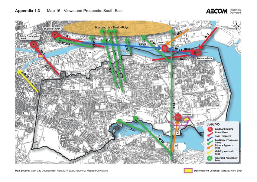
Appendix 1.3: Views and Prospects (extract of Cork City Development Plan Map 16)
AECOM
4
Gateway View SHD, Ballinure, Blackrock, Cork
MWB Two Ltd
Landscape and Visual Impact Assessment

Landscape and Visual Impact Assessment

1.1              Introduction
This application represents one of two phases of development proposed by MWB Two Ltd. at this site, for which
planning permission is being sought concurrently from Cork City Council and An Bord Pleanála, the latter under
the Strategic Housing Development legislation. Collectively, the lands form the Proposed Strategic Housing
Development of Gateway View, where the construction of a total of 246 no residential units and a creche is
proposed. Zoning differences across the site have necessitated a dual approach be adopted to applying for
planning permission.

To the north of the site a Strategic Housing Development application is being made in relation to 179 no.
residential units and a creche across 3 no. 5 – 7 storey blocks, which will be referred to as ’Proposed SHD
Development’ in this report. To the south of the site an application for planning permission for a single 8 storey
apartment block comprising 67 no. units is being made to Cork City Council, which will be referred to as
‘Proposed CCC Development’ in this report.

This report identifies and assesses the potential effects of the Proposed SHD Development on the landscape
and visual resource of the study area in Cork City and adjacent Cork County lands. It identifies mitigation and
compensation measures that will be implemented to prevent, reduce or offset potential adverse Landscape,
visual and cumulative effects or enhance potential beneficial effects.

The report considers how:

      ·   Landscape effects associated with a development relate to changes to the fabric, character and quality
          of the landscape resource and how it is experienced; and
      ·   Visual effects relate closely to landscape effects, but also concern changes in views as visual
          assessment is also concerned with people’s perception and response to changes in visual amenity.
Landscape and visual effects are interrelated with other environmental effects but are assessed separately.
Whilst elements of the built heritage such as Listed Buildings and Conservation Areas are important elements
of the Landscape and contribute to its character and influence its quality and value, effects on the significance
of these designated features and their setting do not form part of this assessment. The following maps are
included in Appendices 1.1 – 1.3:

  ·   Appendix 1.1: Figure 1- Landscape Designations, Cork City

  ·   Appendix 1.2: Figure 2- Landscape Designations, County Cork

  ·   Appendix 1.3: Views and Prospects (extract of Cork City Development Plan Map 16)

The landscape and visual impact assessment is also supported by a booklet of photomontages (prepared by
Pedersen Focus Ltd), which is included as a separate document in the planning application.

Please note that references to the designation mapping in the text will be made as ‘Figure 1’ etc.

1.2              Relevant Legislation, Planning Policies and Guidance
European
The European Landscape Convention provides guidelines for managing landscapes/Landscapes. The
Convention is not an EU Directive. Countries that sign and ratify the Convention make a commitment to
upholding the principles it contains within the context of their own domestic legal and policy frameworks. The
convention was ratified by Ireland in March 2002 and came into effects in Ireland in 2004. The European
Landscape Convention requires “landscape to be integrated into regional and town planning policies and in
cultural, environmental, agricultural, social and economic policies, as well as any other policies with possible
direct or indirect impacts on Landscape”.

                                                                                                           AECOM
                                                                                                               5
Gateway View SHD, Ballinure, Blackrock, Cork
MWB Two Ltd
Landscape and Visual Impact Assessment
National
The National Landscape Strategy (NLS) for Ireland 2015-2025 was launched in May 2015 and is to be
implemented by the Government in the future. The NLS promotes the sustainable protection, management and
planning for the landscape/Landscape. The NLS states that the “National Landscape Strategy will be used to
ensure compliance with the European Landscape Convention and to establish principles for protecting and
enhancing the landscape (Landscape) while positively managing its change. It will provide a high-level policy
framework to achieve balance between the protection, management and planning of the landscape by way of
supporting actions.” It also states that “The Strategy sets out Ireland’s high-level objectives and actions with
regard to landscape (Landscape). It also positions landscape in the context of existing Irish and European
strategies, policies and objectives, and outlines methods of ensuring co-operation at a sectoral and at a
European level by the State.”
Regional (Cork City)
Cork City Development Plan 2015-2021 (CCDP)
This is the main strategic planning policy document which guides the future renewal and development of Cork
City to 2021 and beyond. The Proposed SHD Development is located within the jurisdiction of the CCDP.
Relevant details on planning policies are described in the Planning Policy Context report included in the planning
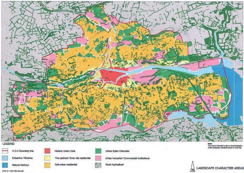
submission package. The Cork City Development Plan identifies and describes the Landscape Character Areas
and Key Landscape Assets of Cork City, as identified in the Cork City Landscape Study 2008. The landscape
study was commissioned by Cork City Council to “establish principles and provide the framework for protecting
and enhancing the natural environment and positively managing its change, as well as providing the context
within which the design of developments can take place in an appropriate manner”.
The Landscape Character Assessment contained within the Cork City Landscape Study 2008, defines 8
Landscape Character Areas within the city as follows:
· Estuarine / Riverine
· Natural harbour
· Historic urban core
· Fine-grained inner-city residential
· Suburban residential
· Urban sylvan character
· Urban industrial / commercial
· Rural agricultural
AECOM
6
Gateway View SHD, Ballinure, Blackrock, Cork
MWB Two Ltd
Landscape and Visual Impact Assessment

Image 1 Landscape Character Areas (Cork City Landscape Study 2008)

Key Landscape Assets contained within the Cork City Landscape Study 2008 and referenced within the Cork
City Development Plan 2015-2021, are identified and categorised in the below table:

Table 1 Key Landscape Assets

   Ref     Assets Category

   A       Topography – ridges, escarpments, slopes

   B       Water / River Corridors – rivers, estuary, harbour, The Lough, Atlantic Pond, Docklands, Port of Cork

   C       Tree Canopy – Areas with existing woodlands or significant tree groups, or areas with potential for new

           woodlands

   D       Ecology – areas which provide a habitat for wild flora and fauna

   E       Visually Important Land (including Views and Prospects of Special Amenity Value, Potential Vantage

           Points and Locally Important Views)

   F       Historic Core / Landscapes / Streetscapes

   G       Landmarks / Natural Features / Cultural Landscape – land forming the setting to existing landmark

           Buildings and/or protected structures / buildings of significance

   H       Public and Private Open Space footprint, including land with potential for Public Open Space

   I       Institutional Open Space

                                                                                                                     AECOM
                                                                                                                         7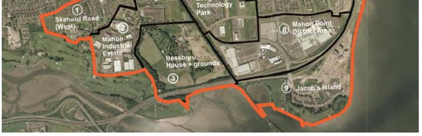
Gateway View SHD, Ballinure, Blackrock, Cork
MWB Two Ltd
Landscape and Visual Impact Assessment

   J       Historic Landscape (including monuments/ historic routes)

   K       Rural Character / Green Belt – proximity of rural and agricultural land uses to the city

   L       Built Form

   M       Public Realm

   O       Gateways to the City

   P       Bridges

   Q       Pedestrian / Cycle Routes in the City / Access

   R       Vehicular Access

   S       The Railway in the City

Key Landscape Assets are illustrated in the CCDP in Figure 10.2 as shown below:

Image 2 Key Landscape Assets Diagram

The CCDP sets out 7 interconnected Strategic Goals, which focus on achieving the vision, set out in the plan.
Relevant goals relating to the protection of the city’s landscape character and key landscape assets are quoted
below:

Goal 5: Maintain and Capitalise on Cork’s Unique Form and Character

“Cork City’s unique character derives from the combination of plan, topography, built fabric and the setting
provided by the River Lee valley. The dramatic east west ridges create the visual setting for the city. The goal of
the Plan is to protect and capitalise on the unique character of the city, both the character derived from the
natural environment and the man-made character created by the built form, while providing opportunities for
new development. New development will be required to respect and reflect the dramatic topography as well as

                                                                                                            AECOM
                                                                                                                8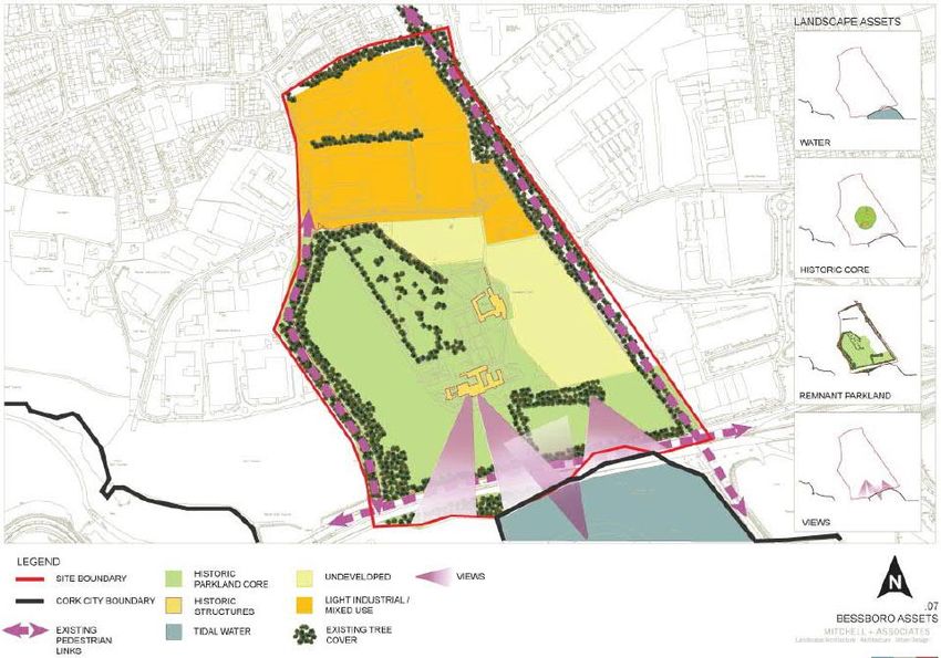
Gateway View SHD, Ballinure, Blackrock, Cork
MWB Two Ltd
Landscape and Visual Impact Assessment

the landscape and ecology of the city. It must also respect the built heritage of the city, in particular areas of
significant historic character such as the City Centre, the historic north-south spine and the historic villages in
the suburbs. There are also opportunities for creation of new character areas in locations such as Docklands,
Mahon and Blackpool and at the arrival points or gateways into the city …”.

Goal 7: Protect and Expand the Green Infrastructure of the City

“The Plan seeks to strengthen the green infrastructure of the city for recreational purposes, to promote
biodiversity and to protect the landscape of the city. A diverse range of recreation and open spaces facilities,
such as sports pitches, public parks, amenity spaces, indoor sports centres, and walking / cycling routes are vital
to the health and wellbeing of Cork’s residents, as well as those working and visiting the city. This green
infrastructure also provides a key ingredient for making the city an attractive place to live, visit and do business
in. The aim of the Plan is to ensure that people have access to an appropriate level of provision of the right quality.
The Plan also seeks to provide linkages and green corridors between areas of open space to support bio-
diversity …”.

The CCDP also contains a number of objectives that relate directly to the protection of the city’s Landscape /
landscape character. Relevant objectives are listed below:

Objective 10.1 Landscape Strategic Objectives

“To preserve and enhance Cork’s landscape character and key landscape assets”.

“To preserve and enhance Cork’s views and prospects of special amenity value”.

Objective 10.2 Cork City Landscape

“To preserve Cork’s unique and distinctive landscape character through appropriate management and
enhancement of Key Landscape Assets”.

Objective 10.3 Cork City Structure Plan

“To preserve and enhance Cork’s landscape and where appropriate, to increase access to and utilise the
landscape for recreational purposes through the implementation of the Landscape Structure Plan”.

Objective 10.4 Areas of High Landscape Value

“To conserve and enhance the character and visual amenity of Areas of High Landscape Value (AHLV) through
the appropriate management of development, in order to retain the existing characteristics of the landscape,
and its primary landscape assets. Development will be considered only where it safeguards to the value and
sensitivity of the particular landscape. There will be a presumption against development where it causes
significant harm or injury to the intrinsic character of the Area of High Landscape Value and its primary landscape
assets, the visual amenity of the landscape; protected views; breaks the existing ridge silhouette; the character
and setting of buildings, structures and landmarks; and the ecological and habitat value of the landscape”.

Objective 10.5 Landscape Preservation Zones

“To preserve and enhance the character and visual amenity of Landscape Preservation Zones through the
control of development. Development will be considered only where it safeguards to the value and sensitivity of
the particular landscape and achieves the respective site-specific objectives”.

Objective 10.6 Views and Prospects

“To protect and enhance views and prospects of special amenity value or special interest and contribute to the
character of the City’s landscape from inappropriate development, in particular those listed in the development
plan. There will be a presumption against development that would harm, obstruct or compromise the quality or
setting of linear views of landmark buildings, panoramic views, river prospects, Landscape and landscape views
and approach road views”.

Objective 10.10 Trees and Urban Woodland
(d) “To ensure that new development benefits from adequate landscape structure / tree coverage, particularly in
areas of the city with inadequate tree coverage”.

                                                                                                                AECOM
                                                                                                                    9
Gateway View SHD, Ballinure, Blackrock, Cork
MWB Two Ltd
Landscape and Visual Impact Assessment

Relevant landscape designations of Cork City and their location in relation to the Proposed SHD Development
is shown in Figure 1.

Views and Prospects
The CCDP states: “Cork City benefits from the prominent ridges which provide a series of striking viewing points
of the city. This important resource helps define the character and identity of the city” and that “In general, the
city is appreciated by most people along viewpoints such as the River Lee and panoramic views from elevated
sites. Amenity views and prospects are defined as those views which significantly contribute to the character
and amenity of the city, namely:

  ·   the visual envelope of the city defined by the ridges to the north and south;

  ·   the city skyline;

  ·   the built and natural heritage of the city”.

The CCDP identifies and describes 5 different view types:

Linear Views of Landmark Buildings – “These occur where a particular landmark / building is the main point of
focus. Views tend to be framed within relatively narrow viewing corridors such as laneways and streets. The views
of landmark buildings are considered to be of particular importance and special amenity value. The majority of
these views are from City Centre or inner-city viewing locations”.

Panoramic Views – “Panoramas are wide views of the city and suburbs (often from elevated sites) featuring a
varying number of city’s landmarks. These panoramic views from specified locations or ‘Panoramic Assessment
Points’ are considered to be of particular importance and are important reference points from which large
development proposals can be assessed in terms of visual impact”.

River Prospects – “River prospects are views of landmark buildings from bridges but also riverbanks and
quaysides”.

Landscape and Landscape Features – “These are views of areas that have distinctive / outstanding Landscape
or landscape features within the city including views of the city ridges”.

Approach Road Views – “The approach roads into Cork City offer visitors the vital ‘first impression’ of the city
and glimpse of the unique topography and character of Cork. Historical routes into the city tend to be from high
vantage points, whereas the national primary roads offer wider viewing corridors”.

The Development Management Chapter in the current Cork City Development Plan sets out objectives for
future development, which include:

Objective 16.1 Design Statement

“All significant planning applications shall submit an accompanying design statement which provides a
framework explaining how a proposed development is a suitable response to the site and its setting”.

Objective 16.2 Visual Impact Assessments

“All significant planning applications shall submit an accompanying visual impact assessment”.

Objective 16.3 Urban Design

  ·   “To deliver high quality-built environments through good place making;

  ·   To ensure that development is designed to high qualitative standard and is cognisant of the need for proper
      consideration of context, connectivity, inclusivity, variety, efficiency, distinctiveness, layout, public realm,
      adaptability, privacy and amenity, parking and detailed design”.

Objective 16.4 Skyline and roofscapes
“The City Council will seek new buildings to be designed to:

  ·   enhance the roofscape in terms of their bulk, massing, materials and aesthetics;

                                                                                                               AECOM
                                                                                                                   10
Gateway View SHD, Ballinure, Blackrock, Cork
MWB Two Ltd
Landscape and Visual Impact Assessment
· where appropriate, divide building mass into smaller elements which respect the existing cityscape and the
setting and views and prospects of landmark buildings and the other special amenity views;
· Where appropriate locate plant housing for buildings in basements to avoid impact on views of cityscape”.
Relevant protected Views and Prospects and their location in relation to the Proposed SHD Development is
shown in Figure 3.
Cork County Development Plan 2014
The Landscape Character Assessment (LCA) of Cork County identifies 16 Landscape Character Types (LCT) for
the region. The study area is predominantly located within Cork City and Harbour, which is identified as City
Harbour & Estuary character type. This LCT is considered to be of Very High Landscape Value, Very High
Landscape Sensitivity and to be of National Landscape Importance. The study area includes areas of High
Landscape Value, Prominent and Strategic Metropolitan Greenbelt Areas and contains sections of designated
Scenic Routes to the south, south east, east and west, as illustrated in Figure 2.
Local (Mahon)
Mahon Local Area Plan 2014 (LAP)
The Mahon LAP was prepared within the duration of the Cork City Development Plan 2009-2015. The aim of the
plan is to set objectives with the intention of transforming the area into a cohesive, connected and well-serviced
neighbourhood and employment area. The LAP will provide a long-term strategy for the development of the
Mahon area for the period of 2011-2031. This long-term strategy sets out the following development outcomes
for the area:
· New employment opportunities within the Mahon Technology Park in the form of offices and light industry;
· A new “Bessboro House” residential neighbourhood within the Mahon Industrial Estate and Bessboro
House grounds;
· The completion of Ursuline Convent and Jacob’s Island as residential neighbourhoods;
· An improved Avenue De Rennes and Mahon Point Shopping Centre to provide focal points for community,
social and services activity;
· A new Neighbourhood Park on the grounds of Bessboro House, providing a focus for recreational activity
in Mahon and a valuable landscape asset for public benefit;
· Significant improvements to transport, community and civic infrastructure to provide for the needs of the
area;
· A significantly improved network of streets and spaces of character.
1.3 Scope
1.3.1 Study Area
A study area of 1.5 km, from the boundary of the Proposed SHD Development site, has been selected to identify
potential significant Landscape and visual effects within Cork City (refer to Figure 1). The extent of the study area
has been identified through a review of maps and aerial photographs of the development site and a site survey.
It is acknowledged that the Proposed SHD Development may be visible from locations beyond the study area,
mainly from elevated locations, and as such it is important to note that the 1.5 km study area defines the area
within which potential effects could be significant, rather than defining the extent of visibility.
Photomontages have been produced to illustrate views from representative viewpoints located within the study
area radius.
AECOM
11Gateway View SHD, Ballinure, Blackrock, Cork
MWB Two Ltd
Landscape and Visual Impact Assessment
1.3.2 Temporal Scope
The Proposed SHD Development will involve the introduction of residential buildings into an area comprising
mainly grassland and tree vegetation creating the potential for landscape and visual effects. The type and
duration of the Landscape and visual effects fall within two main stages as follows:
Construction (temporary and of a short duration)
· Potential physical effects arising from construction of the development on the landscape resource within
the development application boundary area;
· Potential effects to landscape character or visual amenity within the wider study area as a result of visibility
of construction activities or the development during construction;
· Effects of temporary site infrastructure such as – site traffic; construction compounds; and
· Potential effects of partially built development in various stages of construction.
Operational
· Potential effects of the Proposed SHD Development on landscape resources and landscape character,
including the perceptual qualities of the landscape;
· Potential effects of the Proposed SHD Development on views and visual amenity; and
· Potential cumulative effects of the development in combination with other planned and Proposed SHD
Developments of a similar type and scale upon the landscape and visual resource of the study area.
1.3.3 Effects Scoped Out
The proposed residential buildings and associated infrastructure will become a permanent feature in the
landscape following the completion of construction works and the implementation of landscape mitigation
measures. The assessment takes account of this in the determination of residual landscape and visual effects.
Cork County landscape designations have been reviewed as part of this assessment. A number of these
designations are now located within the boundaries of Cork City Council following the extension of the Cork City
boundaries into Cork County in 2019. Given the nature of the development, its location, scale and setting, it is
considered unlikely that there will be any significant visual effect on lands within the Cork County Council
administrative area.
Cork City Council and Cork County Council have commenced the preparation of new separate Development
Plans for the period 2022-2028. The preparations are still at Pre Draft Stage and do not warrant inclusion in this
assessment.
1.4 Methodology
This section sets out the methodology for the Landscape and Visual Impact Assessment (LVIA) as a result of the
Proposed SHD Development.
1.4.1 Guidance and other information used in the Landscape and Visual
Impact Assessment
The following sources and guidelines were used in the assessment:
· EPA “Guidelines on the information to be contained in Environmental Impact Assessment Reports”, Draft,
August 2017;
· ‘Guidelines for Landscape and Visual Impact Assessment’ (GLVIA), 3rd Edition, 2013, Landscape Institute
(UK) & IEMA;
AECOM
12Gateway View SHD, Ballinure, Blackrock, Cork
MWB Two Ltd
Landscape and Visual Impact Assessment
· ‘Visual Representation of Development Proposals’, Landscape Institute, Technical Guidance Note 06/19, 17
September 2019;
· Cork City Development Plan 2015-2021;
· Cork County Development Plan 2014;
· Mahon Local Area Plan 2014;
· National Parks and Wildlife Service (NPWS), http://www.npws.ie/;
· https://www.sportireland.ie/outdoors/find-your-trails/; and
· Ordnance Survey Ireland, 1:50,000 Discovery Mapping.
1.4.2 Landscape and Visual Impact Assessment Criteria
This report has been prepared based on the Environmental Protection Agency (EPA) Draft guidance document
‘Guidelines on the Information to be contained in Environmental Impact Assessment Reports, 2017, EPA
guidance documents. Best practice guidance, such as the “Guidelines for Landscape and Visual Impact
Assessment, 3rd Edition (GLVIA3), 2013, Landscape Institute (UK) & IEMA” provide specific guidelines for
landscape and visual impact assessments. Therefore, a combination of the draft EPA guidelines, the Landscape
Institute guidelines and professional experience has informed the methodology for the assessment herein. The
Landscape Institute guidelines require the assessment to identify, predict and evaluate the significance of
potential effects to landscape characteristics and established views. The assessment is based on an evaluation
of the sensitivity to change and the magnitude of change for each landscape or visual receptor. For clarity, and
in accordance with best practice, the assessment of potential effects on landscape character and visual amenity,
although closely related, are undertaken separately.
The assessment acknowledges that landscape and visual effects change over time as the existing landscape
external to the proposed development evolves and proposed planting establishes and matures.
The significance of an effect or impact is determined by two distinct considerations:
1. The Nature of the receptor likely to be affected, namely:
o The value of the receptor;
o The susceptibility of the receptor to the type of change arising from the proposed developments; and
o The sensitivity to change is related to the value attached to the receptor.
2. The Magnitude of the effect likely to occur, namely:
o The size and scale of the landscape and visual effect (for example, whether there is a complete or
minor loss of a particular landscape element);
o The geographical extent of the areas that will be affected;
o The duration of the effect and its reversibility; and
o The quality of the effect – whether it is neutral, positive or negative.
The table below provides the definition of the duration of both landscape and visual effects.
Table 2 Definition of Duration of Effects
Duration Description
Temporary Effects lasting one year or less
Short Term Effects lasting one to seven years
Medium Term Effects lasting seven to fifteen years
Long Term Effects lasting fifteen to sixty years
Permanent Effects lasting over sixty years
AECOM
13Gateway View SHD, Ballinure, Blackrock, Cork
MWB Two Ltd
Landscape and Visual Impact Assessment
The quality of both Landscape and visual effects is defined in the table below:
Table 3 Definition of Quality of Effects
Quality of Effects Description
Neutral This will neither enhance nor detract from the landscape character or view
Positive (Beneficial) This will improve or enhance the landscape character or view
Negative (Adverse) This will reduce the quality of the existing landscape character or view
1.4.3 Assessment Process
The assessment is undertaken based on the following key tasks and structure:
· Establishment of the Baseline or receiving environment;
· Appreciation of the proposed development; and
· Assessment of effects.
1.4.4 Establishment of the Receiving Environment
A baseline study has been undertaken through a combination of desk-based research and site appraisal in order
to establish the existing conditions of the landscape and visual resources of the study area. Desk based research
has involved a review of mapping and aerial photography, relevant planning and policy documents, the relevant
Landscape Character Assessments and other relevant documents and publications.
1.4.5 Appreciation of the proposed development
In order to be able to accurately assess the full extent of likely effects on landscape character and visual amenity
it is essential to develop a thorough and detailed knowledge of the proposed development. This includes a
comprehensive understanding of its location, nature and scale and is achieved through a review of detailed
descriptions of the proposed development and drawings (see Planning Application Drawings accompanying the
application) and an on-site appraisal.
The landscape and visual impact assessment has considered all elements of the Proposed SHD Development.
1.4.6 Assessment of Effects
The landscape and visual impact assessment seeks to identify, predict and evaluate the significance of potential
effects to landscape characteristics and established views. The assessments are based on an evaluation of the
sensitivity to change and the magnitude of change for each landscape or visual receptor.
The assessment acknowledges that landscape and visual effects change over time as the existing landscape
internal and external to the proposed development evolves. The assessment therefore reports on potential
effects during both construction/operation and completion of the proposed development. The prominence of
the proposed development in the landscape or view will vary according to the existing screening effects of local
topography, intervening existing vegetation and building structures.
GLVIA3 requires that a clear distinction is drawn between landscape and visual effects:
· Landscape effects relate to the degree of change to characteristics or physical components of an urban
area, which together form the character of that landscape, e.g. topography, streets, buildings and open
space.
· Visual effects relate to the degree of change to an individual receptor's or a receptor group's view of that
landscape, e.g. local residents, users of public open space, footpaths or motorists passing through the area.
As mentioned in the scope above, construction and operational stages of the proposed development are
assessed separately. Distinctions may be drawn between temporary and permanent effects, with permanent
AECOM
14Gateway View SHD, Ballinure, Blackrock, Cork
MWB Two Ltd
Landscape and Visual Impact Assessment
effects typically being of greater importance. Residual effects are those likely to arise from the proposed
development taking into account all embedded measures.
The assessment forms part of an iterative process where, as potentially significant effects are identified, these
inform the design of the proposed development. Mitigation of the development has been considered throughout
the process, including site layout, consultation and design development. This process and the considerations,
which informed it, are described within the Design Statement included in the planning submission package.
When considering the potential effect of changes that a future development may have on the landscape and
visual resource it is necessary to identify those key elements of the landscape which make it distinctive. These
can be seen as layers which overlay each other and vary in dominance from place to place. These layers mainly
comprise of the buildings, structures and spaces which influence the pattern of uses, activity and movement in
a place and the experience of those who visit, work and live there.
The Landscape Character Assessment for Cork City contained within the Cork City Landscape Study 2008 and
referred to within the Cork City Development Plan, defines 8 Landscape Character Areas within the city. Each
character area provides a brief description of a particular area and key objectives supplementing development
management guidelines. AECOM has studied these as well as the existing landscape character and city centre
skyline, the setting of the existing site and its environs on site in order to understand the baseline character,
where common settlement patterns and landscape features and elements are evident.
Cumulative effects arise from changes brought about by one development in conjunction with another of similar
character. Cumulative effects are considered where the presence of developments of a similar type or scale, that
have planning consent but are not constructed, or that are the subject of undetermined applications may have a
combined effect on the perception of landscape character and visual amenity.
1.4.7 Landscape Effects
Landscape effects describe the impact on the fabric or structure of a landscape or landscape character. The
assessment of landscape effects firstly requires the identification of the components of the landscape. The
landscape components are also described as landscape receptors and comprise the following:
· Individual landscape elements or features;
· Specific aesthetic or perceptual aspects; and
· Landscape character, or the distinct, recognisable and consistent pattern of elements (natural and man-
made) in the landscape that makes one landscape different from another.
The assessment will identify the interaction between these components and the proposed development during
construction and operational phases. The condition of the landscape and any evidence of current pressures
causing change in the landscape will also be documented and described.
Landscape Value
Landscape value is frequently addressed by reference to international, national, regional and local designations,
determined by statutory and planning agencies. However, absence of such a designation does not necessarily
imply a lack of quality or value. Factors such as accessibility and local scarcity can render areas of nationally
unremarkable quality, highly valuable as a local resource. The quality and condition is also considered in the
determination of the value of a landscape. The evaluation of landscape value is undertaken with reference to the
definitions stated in the table below:
Table 4 Landscape Value
Landscape Value Classification Criteria
High Nationally designated or iconic, unspoilt landscape with few, if any, degrading elements.
Medium Regionally or locally designated landscape, or an undesignated landscape with locally important
landmark features and some detracting elements.
Low Undesignated landscape with few if any distinct features or with several degrading elements.
AECOM
15Gateway View SHD, Ballinure, Blackrock, Cork
MWB Two Ltd
Landscape and Visual Impact Assessment
Landscape Susceptibility
Landscape susceptibility relates to the ability of a particular landscape to accommodate the proposed
development. Landscape susceptibility is appraised through consideration of the baseline characteristics of the
landscape, and in particular the scale or complexity of a given landscape.
The evaluation of landscape susceptibility is undertaken with reference to a three-point scale, as outlined in the
table below:
Table 5 Landscape Susceptibility Criteria
Landscape Susceptibility Classification Criteria
High Small scale, intimate or complex landscape considered to be intolerant of even minor change.
Medium Medium scale, more open or less complex landscape considered tolerant to some degree of
change.
Low Large scale, simple landscape considered tolerant of a large degree of change.
Landscape Sensitivity
Landscape sensitivity to change is determined by employing professional judgment to combine and analyse
the identified landscape value, quality and susceptibility and is defined with reference to the scale outlined in
the table below:
Table 6 Landscape Sensitivity to Change Criteria
Landscape
Classification Criteria
Sensitivity
High · Landscape characteristics or features with little or no capacity to absorb change without fundamentally
altering their present character.
· Landscape designated for its international or national landscape value or with highly valued features.
· Outstanding example in the area of well cared for landscape or set of features that combine to give a
particularly distinctive sense of place.
· Few detracting or incongruous elements.
Medium-High · Landscape characteristics or features with a low capacity to absorb change without fundamentally
altering their present character.
· Landscape designated for regional or county-wide landscape value where the characteristics or
qualities that provided the basis for their designation are apparent or a landscape with highly valued
features locally.
· Good example in the area of a well-cared for landscape or set of features that combine to give a clearly
defined sense of place.
Medium · Landscape characteristics or features with moderate capacity to absorb change without fundamentally
altering their present character.
· Landscape designated for its local landscape value or a regional designated landscape where the
characteristics and qualities that led to the designation of the area are less apparent or are partially
eroded or an undesignated landscape which may be valued locally – for example an important open
space.
· An example of a landscape or a set of features which is relatively coherent, with a good but not
exceptional sense of place - occasional buildings and spaces may lack quality and cohesion.
Medium-Low · Landscape characteristics or features which are reasonably tolerant of change without determent to
their present character.
· No designation present or of little local value.
· An example of an un-stimulating landscape or set of features; with some areas lacking a sense of place
and identity.
Low · Landscape characteristics or features which are tolerant of change without determent to their present
character.
AECOM
16Gateway View SHD, Ballinure, Blackrock, Cork
MWB Two Ltd
Landscape and Visual Impact Assessment
Landscape
Classification Criteria
Sensitivity
· An area with a weak sense of place and/or poorly defined character /identity.
· No designation present or of low local value or in poor condition.
· An example of monotonous unattractive visually conflicting or degraded landscape or set of features.
Landscape Receptors
The landscape resources within the study area that could be affected by the development include:
· Physical resources such as buildings, open space, trees, watercourses etc.;
· Designated, valued or recognised components that contribute to landscape character; and
· Cultural heritage interests that contribute to landscape character.
landscape receptors are defined as those landscape resources within the study area from which the
development may be visible or where potential visibility of the development in one part of the landscape
resource affects the experience of another part. Field assessment studies were used to check the potential
visibility of the development from the landscape resources within the study area. Within this section specific
consideration is also given to changes to landscape elements such as the built fabric, open space or trees.
Sensitivity of Landscape Receptors
The sensitivity of a landscape receptor is an expression of its ability to accommodate the proposed development
as part of its own character. The sensitivity of a landscape varies according to the nature of the existing resource
and the nature of the proposed changes as a result of the proposed development. The sensitivity of the
landscape is based on interpretation of a combination of judgements relating to their susceptibility to the type
of change or development proposed and the value attached to the landscape.
Landscape Character
Landscape character is a complex mix of physical features and patterns and cultural elements. Buildings,
structures and spaces and the resulting layout and urban grain, the density and mix, scale and appearance,
human interaction and cultural and historic features combine to create a common ‘sense of place’ and identity
that is experienced as landscape character. Definable units (character areas and character zones) can be used
to categorise the landscape and the level of detail and size of unit can be varied to reflect the scale of definition
required. It can be applied at national, regional and local levels.
The quality or condition of a landscape character receptor is a reflection of its attributes, such as the condition
of the buildings and spaces or vegetative components and the attractiveness and landscape quality of the area
as well as its sense of place. A landscape with consistent, intact and well-defined, distinctive attributes is
generally considered to be of higher quality and in turn, higher sensitivity, than a landscape where the presence
of inappropriate or discordant elements has detracted from its inherent attributes. The higher the quality of a
receptor the greater is its sensitivity to the proposed development.
Magnitude of Landscape Change
Magnitude of change is an expression of the size or scale of change in the landscape, the geographical extent
of the area influenced and the duration and reversibility of the resultant effect. The variables involved are
described below:
· The extent of existing landscape elements that will be lost, the proportion of the total extent that this
represents and the contribution of that element to the character of the landscape;
· The extent to which aesthetic or perceptual aspects of the landscape are altered either by removal of
existing components of the landscape or by addition of new ones;
· Whether the effect changes the key characteristics of the landscape, which are integral to its distinctive
character;
AECOM
17Gateway View SHD, Ballinure, Blackrock, Cork
MWB Two Ltd
Landscape and Visual Impact Assessment
· The geographic area over which the landscape effects will be felt (within the proposed development site
itself; the immediate setting of the proposed development site; at the scale of the landscape type or
character area; on a larger scale influencing several landscape types or character areas); and
· The duration of the effects (short term, medium term or long term) and the reversibility of the effect
(whether it is permanent, temporary or partially reversible).
Changes to landscape characteristics can be both direct and indirect. Direct change occurs where the
proposed development will result in a physical change to the landscape within or adjacent to the proposed
development site. Indirect changes are a consequence of the direct changes resulting from the proposed
development. They can often occur away from the proposed development site (for example, off-site
construction staff parking) and may be a result of a sequence of interrelationships or a complex pathway (for
example, a new road or footpath construction may increase public access and associated problems e.g. littering).
They may be separated by distance or in time from the source of the effects. The magnitude of change affecting
the baseline landscape resource is based on an interpretation of a combination of the criteria set out in the table
below:
Table 7 Magnitude of Landscape Change Criteria (Landscape Effects)
Magnitude of Landscape Change Classification Criteria
None · No change.
Negligible · Little perceptible change.
Low · Minor change, affecting some characteristics and the experience of the
landscape to an extent; and
· Introduction of elements that is not uncharacteristic.
Medium · Noticeable change, affecting some key characteristics and the
experience of the landscape; and
· Introduction of some uncharacteristic elements.
High · Noticeable change, affecting many key characteristics and the
experience of the landscape; and
· Introduction of many incongruous developments
Very High · Highly noticeable change, affecting most key characteristics and
dominating the experience of the landscape; and
· Introduction of highly incongruous development.
1.4.8 Visual effects
Visual effects are determined by the extent of visibility and the nature of the visibility (i.e. how a development is
seen within the landscape); for example, whether it appears integrated and balanced within the visual
composition of a view or whether it creates a focal point.
Negative visual effects may occur through the intrusion of new elements into established views, which are out
of keeping with the existing structure, scale and composition of the view. Visual effects may also be beneficial,
where an attractive focus is created in a previously unremarkable view or the influence of previously detracting
features is reduced. The significance of effects will vary, depending on the nature and degree of change
experienced and the perceived value and composition of the existing view.
Receptors
For there to be a visual impact, there is the need for a viewer. Views experienced from locations such as
settlements, recognised routes and popular vantage points used by the public have been included in the
assessment. Receptors are the viewers at these locations. The degree to which receptors, i.e. people, will be
affected by changes as a result of the proposed development depends on a number of factors, including:
· Receptor activities, such as taking part in leisure, recreational and sporting activities, travelling or working;
AECOM
18Gateway View SHD, Ballinure, Blackrock, Cork
MWB Two Ltd
Landscape and Visual Impact Assessment
· Whether receptors are likely to be stationary or moving and how long they will be exposed to the change at
any one time;
· The importance of the location, as reflected by designations, inclusion in guidebooks or other travel
literature, or the facilities provided for visitors;
· The extent of the route or area over which the changes will be visible;
· Whether receptors will be exposed to the change daily, frequently, occasionally or rarely;
· The orientation of receptors in relation to the proposed development and whether views are open or
intermittent;
· Proportion of the developments that will be visible (full, sections or none);
· Viewing direction, distance (i.e. short-, medium- and long-distance views) and elevation;
· Nature of the viewing experience (for example, static views, views from settlements and views from
sequential points along routes);
· Accessibility of viewpoint (public or private, ease of access);
· Nature of changes (for example, changes in the existing skyline profile, creation of a new visual focus in the
view, introduction of new man-made objects, changes in visual simplicity or complexity, alteration of visual
scale, landform and change to the degree of visual enclosure); and
· Nature of visual receptors (type, potential number and sensitivity of viewers who may be affected).
Value of the View
Value of the view is an appraisal of the value attached to views and is often informed by the appearance on
Ordnance Survey of tourist maps and in guidebooks, literature or art. Value can also be indicated by the
provision of parking or services and signage and interpretation. The nature and composition of the view is also
an indicator. The value of the view is determined with reference to the definitions outlined in the table below:
Table 8 Value of the View
Value Classification Criteria
High Nationally recognised view of the landscape, with no detracting elements.
Medium Regionally or locally recognised view, or unrecognised but pleasing and well composed view, with
few detracting elements.
Low Typical or poorly composed view often with numerous detracting elements.
Visual Susceptibility
The GLVIA guidelines identify that the susceptibility of visual receptors to changes in views and visual amenity
is a function of:
· The occupation or activity of people experiencing the view at a particular location; and
· The extent to which their attention or interest may therefore be focused on the views and visual amenity
they experience at particular locations.
For example, residents in their home, walkers whose interest is likely to be focused on the landscape or a
particular view, or visitors at an attraction where views are an important part of the experience often indicate a
higher level of susceptibility. Whereas receptors occupied in outdoor sport, where views are not important, or at
AECOM
19You can also read